International Civil Aviation Organization. CNS Planning and Implementation in the MID Region GNSS PLANNING AND IMPLEMENTATION
|
|
|
- Juniper Geoffrey Mitchell
- 5 years ago
- Views:
Transcription
1 CNS SG/8-WP/10 17/1/2018 International Civil Aviation Organization MIDANPIRG Communication, Navigation and Surveillance Sub-Group Eighth Meeting (CNS SG/8) (Cairo, Egypt, February 2018) Agenda Item 4: CNS Planning and Implementation in the MID Region GNSS PLANNING AND IMPLEMENTATION (Presented by Secretariat) SUMMARY The aim of this paper is to present the outcome of the ACAC/ICAO CNSS Workshop. The paper presents also a Draft Guidance on GNSS Implementation in the MID Region, for review and inputs by the meeting. Action by the meeting is at paragraph 3 REFERENCES - MIDANPIRG/16 Report 1. INTRODUCTION 1.1 GNSS is defined by ICAO SARPs as a worldwide position and time determination system that includes one or more satellite constellations, aircraft receivers and system integrity monitoring, augmented as necessary to support the required navigation performance for the intended operation. 1.2 The 12th Air Navigation Conference agreed that Multi-constellation, Multi-frequency GNSS has clear technical advantages that will support the provision of operational benefits. To realize these benefits, ICAO, States, ANSPs, standards bodies, manufacturers and aircraft operators need to coordinate activities to address and resolve related issues.
2 CNS SG/8-WP/ DISCUSSION ACAC/ICAO GNSS Workshop 2.1 The ACAC/ICAO GNSS Workshop was held in Rabat, Morocco, 6-7 November The Workshop was supported by European Commission and attended by a total of forty-nine (49) participants, from nine (9) States (Algeria, Egypt, France, India, Lebanon, Libya, Morocco, Tunisia and Yemen), six (6) Organizations (ACAC, ICAO, IFALPA, EC, JPO and IATA) and six (6) Industries (Telespazio, Thales Alenia Space, DLC Consultant ESSP, RESYS Consultants and Abdus Salam International Center for Theoretical Physics). Only four (4) MID States attended the Workshop (Egypt, Lebanon, Libya and Yemen). 2.2 The Workshop discussed mainly the following topics: a) Global and Regional Developments related to GNSS b) Regional SBAS: EGNOS and SBAS initiative for GCC States, Iraq and Yemen c) SBAS Initiative in East Africa and GAGAN d) Panel Discussion on GNSS/SBAS implementation e) GBAS implementation f) GNSS vulnerabilities and mitigation measures. 2.3 The objective of the Workshop was to provide a forum for sharing the current and future developments related to GNSS with a focus on SBAS and GBAS implementation and GNSS vulnerability and mitigation measures. The Summary of Discussion is at Appendix A. Guidance material on GNSS Implementation in the MID Region 2.4 GNSS is a key enabler of the PBN Implementation in the MID Region. Guidance material on GNSS Implementation has been developed to complement the information in the PBN Plan and provide guidance on the implementation aspects of GNSS in order to assist States in the introduction of GNSS operations. The Draft Guidance on GNSS Implementation in the MID Region is at Appendix B. 2.5 The Global Air Navigation Plan, Aviation System Block Upgrades (ASBU) methodology, MID Region Air Navigation Plan and the MID Region Air Navigation Strategy, in addition to the Assembly Resolutions and the twelfth Air Navigation Conference (AN-Conf/12) Recommendations related to GNSS have been considered in the development of the guidance material on GNSS Implementation in the MID Region.
3 -3- CNS SG/8-WP/10 3. ACTION BY THE MEETING 3.1 The meeting is invited to: a) consider the outcome of ACAC/ICAO GNSS Workshop; b) review and update, as deem necessary, the Guidance on GNSS Implementation in the MID Region at Appendix B; and c) endorse the following Draft Conclusion: DRAFT CONCLUSION 8/X: GUIDANCE ON GNSS IMPLMENTATION That, States review the Draft Guidance on GNSS Implementation in the MID Region at Appendix 8X, and provide the ICAO MID Office with their comments/inputs by 15 May 2018 in order to present the consolidated version to the ANSIG/3 meeting for further review and improvement

. 1.2. Opening 1.2.1 Mr.")


, six (6) Organizations (ACAC, ICAO, IFALPA, EC, JPO and IATA) and six (6) Industries (Telespazio,")

4 CNS SG/8 -WP/10 APPENDIX A International Civil Aviation Organization ACAC/ICAO MID WORKSHOP ON GNSS (Rabat-Morocco, 7-8 November 2017) SUMMARY OF DISCUSSIONS 1. GENERAL 1.1. Place and Duration The ACAC/ICAO GNSS Workshop was successfully held at the Golden Tulip Farah Hotel, Rabat, Morocco, 7 and 8 November The Workshop was supported by the European Commission (EC) Opening Mr. Mohamed REJEB, ACAC Air Navigation and Aviation Safety Expert opened the Workshop on behalf of His Excellency Eng. Mohamed Ibrahim Sherif, Director General of ACAC.Mr. Mohamed Smaoui, Deputy Regional Director, ICAO Middle East Regional Office provided also an opening speech on behalf of ICAO Attendance The Workshop was attended by a total of forty-nine (49) participants, from nine (9) States (Algeria, Egypt, France, India, Lebanon, Libya, Morocco, Tunisia and Yemen), six (6) Organizations (ACAC, ICAO, IFALPA, EC, JPO and IATA) and six (6) Industries (Telespazio, Thales Alenia Space, DLC Consultant ESSP, RESYS Consultants and Abdus Salem International Center for Theoretical Physics). The List of Participants is at Attachment A Agenda The Agenda was developed around the main following topics: a) Session 1: Global and Regional Developments related to GNSS b) Session 2: Regional SBAS: EGNOS and SBAS initiative for GCC States, Iraq and Yemen c) Session 3: SBAS Initiative in East Africa and GAGAN d) Session 4: Panel Discussion on GNSS/SBAS implementation e) Session 5: GBAS implementation f) Session 6: GNSS vulnerabilities and mitigation measures g) Session 7: Conclusions and Closing Session
5 The Work Programme is at Attachment B. 2. WORKSHOP OBJECTIVES 2.1 The main objectives of the Workshop were to provide a forum for sharing the current and future developments related to GNSS with a focus on SBAS and GBAS implementation and GNSS vulnerability and mitigation measures. 3. Sessions of the Seminar 3.1 Thirteen (13) presentations were delivered during the six (6) Sessions of the Workshop. Sufficient time was allocated for discussion to identify the priority areas and examine possible partnerships that could be established. 3.2 The presentations are available on the ACAC and ICAO MID websites: and 4. CONCLUSIONS/RECOMMENDATIONS 4.1 The Workshop developed the following Conclusions/Recommendations: The Workshop was apprised of the Global and Regional Developments related to GNSS implementation, including the MID Region Air Navigation Strategy, the MID Region PBN Implementation Plan and the ACAC GNSS Strategy. The Workshop was apprised of EGNOS Status, roadmap and extension to EUROMED. It was noted that five (5) ACAC/EUROMED States have already officially notified their interest in EGNOS implementation (Algeria, Jordan, Lebanon, Libya, and Tunisia). The extension of the EGNOS coverage to the EUROMED States requires the deployment of three (3) additional RIMS. Interested States to use EGNOS Safety of Life (SoL) service need to initiate negotiation with the EC for the signature of an EGNOS International Agreement in parallel with the RIMS installation, and provision of technical assistance. EGNOS provision of SoL Service includes NPA, APV-I and LPV-200 service levels. The Workshop was apprised of the results of the study case carried out by Thales related to the implementation of an Autonomous SBAS system for the GCC States, Iraq and Yemen. The Workshop noted the outcomes of the CBA and the methodology used, as well as the recommendations from CBA related to the ANSPs and States. The Workshop noted the availability on the European side of a pool of industries, which can provide a complete range of support needed for the development of and operation of a turn-key SBAS system up-to service provision. ACAC/ICAO MID GNSS WS 2
6 -3- The Workshop was apprised of the Programme management Office (JPO) activities related to GNSS, including the benefits analysis for SBAS implementation in East Africa. The Cost Benefit Analysis is foreseen as the next step to support the choice of the technical scenario. The Workshop noted the challenges faced by JPO related to the data collection from some States for the development of the CBA. The Workshop was apprised of the GAGAN developments and the possibility to extend services to the MID States. Interested states need to approach CAA INDIA for further coordination. The workshop noted that SARPs are available for GBAS CAT I. For CAT II/III the SARPs are under development. The Workshop was apprised of France experience related to GBAS implementation, including the outcomes of the Paris CDG GBAS Study, which was not very positive in terms of replacement of the current ILSs by GBAS, due mainly to low level of fleet equipage, lack of standards (for CAT II/III) and need to modify the ATC tools. GBAS implementation is currently not economical for small airports (1 RWY). The cost of 1 GBAS is around 1.5 to 2 M Euros per Station (# cost of 3 ILSs). The need for business case before any GBAS implementation, considering inter-alia, fleet equipage was underlined. It was noted that GBAS CAT I is being implemented in few parts of the world, however, overall GBAS CAT I deployment remains limited. The Workshop was apprised of the effects of solar radio bursts on GNSS operations by Prof. Sandro RADICELLA, Abdus Salam International Center for Theoretical Physics. As part of the GNSS vulnerability issues, Dr. Adlen LOUKIL, from Tunisia University made a presentation on Cybersecurity, safety and resilience, and the need of developing national Security policy against cyber threats including awareness and training programmes. States are encouraged to implement best practices related to GNSS Vulnerabilities mitigation measures, as per ICAO guidance material, including the coordination between CAA and Military Authorities related to GNSS interferences. The Workshop was apprised of and supported the MIDANPIRG outcome related to the reporting of GNSS Vulnerability incidents/ occurrences, including the development of a RASG-MID Safety Advisory (RSA) related to GNSS vulnerabilities and mitigations measures. The Workshop noted the IATA position with regard to SBAS implementation. The Workshop reiterated the ANC/12 Recommendations related to GNSS Vulnerabilities: Recommendation 6/6 Use of multiple constellations. Recommendation 6/7 Assistance to States in mitigating global navigation satellite system vulnerabilities. Recommendation 6/8 Planning for mitigation of global navigation satellite system (GNSS) vulnerabilities. Recommendation 6/9 Ionosphere and space weather information for future global navigation satellite system implementation.
7 -4- States are encouraged to embrace early benefits from Basic GNSS (ABAS) implementation (PBN RNP APCH operations). States to keep pace with GNSS global and regional developments, and explore all possible solutions to achieve the required performance objectives, in accordance with the GANP and regional priorities and plans. The regional and national GNSS implementation plans/strategies should be linked to the regional ASBU implementation Plans approved by the relevant PIRG. Airspace users should be involved in the planning of any GNSS implementation, in order to take into consideration operational needs and fleet capabilities. 5. CLOSING 5.1 In closing, Mr. Mohamed Rejeb, Air Navigation and Safety ACAC Expert and Mr. Mohamed Smaoui, Deputy Regional Director, ICAO Middle East Regional Office thanked the participants for their presence and expressed ACAC/ICAO MID gratitude to the States, EC and all the stakeholders from International Organizations/Industry for their valuable contributions and excellent support to the Workshop. 5.2 The participants recognized the usefulness of the event and expressed their thanks to ACAC/ICAO MID for organizing such a fruitful Workshop and underlined the importance of necessary follow-up actions on the Recommendations & Conclusions mentioned above, and the conduct of additional Joint ACAC/ICAO MID Workshops ACAC/ICAO MID GNSS WS 4
8 CNS SG/8 -WP/10 APPENDIX B AMENDMENTS The MID Region GNSS Roadmap should be reviewed and updated by the CNS Sub Group. States shall submit their proposal for amendment to the Plan to the ICAO MID Regional Office, the changes can be coordinated by correspondence with main CNS focal points/ or issuing state letters. The table below provides a means to record all amendments. An up to date electronic version of the Plan will be available on the ICAO MID Regional Office website. Edition Date Comment Section affected 11/2/2018 All V0.1
9 TABLE OF CONTENTS Acronyms.. 5 The objective and scope of the document. 6 Part I: General Navigation Infrastructure Terrestrial Navigations Global Navigation Satellite System (GNSS) GPS GLONASS Galileo BeiDou RNSS Augmentation Satellite based Augmentation System (SBAS) WAAS EGNOS GAGAN SDCM MSAS Ground Based Augmentation System (GBAS) Aircraft Based Augmentation System (ABAS) Receiver Autonomous Integrity System (RAIM) Aircraft Autonomous Integrity System (AAIM) Global Air Navigation Plan (GANP). 14 Part II: GNSS in ICAO MID Region The Conventional Ground Based Navigation Systems in the 16 MID. 2. SBAS EGNOS GAGAN GNSS Application in the MID Region GBAS Cost Benefits Analysis Current use of SBAS/GBAS in the MID Region.. 23 Part III: GNSS Vulnerabilities 24 1 Introduction Unintentional Interference Source Solar Effect. 24 Guidance on GNSS Implementation in the MID Region Page 3
10 2 2 Radio Frequency Interference Onboard Systems Intentional Interference Sources Jamming Spoofing Reducing the likelihood of Interference Mitigation Strategies.. 26 References Appendix A: List of NDBs in the MID Region List of Figures 1 1 Current and Planned SBAS Systems GANP Navigation Roadmap APV I Availability Map APV I Continuity Map LPV200 Availability Map LPV200 Continuity Map GAGAN GEO Footprint.21 List of Tables 2 1 Current Conventional Infrastructure Minimum signal in space performance..20 Guidance on GNSS Implementation in the MID Region Page 4
11 ACRONYMS AO AAIM ABAS APCH CAPEX DME DOP EGNOSS FD FDE GAGAN GBAS GLONASS GLS GNSS GPS ILS INS IRS LNAV MLS MSAS NDB NPA NSE OPEX PA PBN RAIM RNAV RNP SBAS SDCM VOR Aircraft Operators Aircraft Autonomous Integrity Monitoring Aircraft Based Augmentation System Approach Capital Expenditure Distance Measuring Equipment Dilution of Precision European Geostationary Navigation Overlay Service Fault Detection Fault Detection and Exclusion GPS Aided GEO Augmented Navigation Ground Based Augmentation System Global Navigation Satellite System GBAS Landing System Global Navigation Satellite System Global Positioning System Instrument Landing System Inertial Navigation System Inertial Reference System Lateral Navigation Microwave Landing System MTSAT Satellite based Augmentation System Non Directional Beacon Non precision Approach Navigation Sensor Error Operating Expense Precision Approach Performance Based Navigation Receiver Autonomous Integrity Monitoring Area Navigation Required Navigation Performance Satellite Based Augmentation System of Differential Correction and Monitoring Very High Frequency Omni Directional Radio Range Guidance on GNSS Implementation in the MID Region Page 5
12 THE OBJECTIVE AND SCOPE OF THE DOCUMENT The objective of this document is to provide States in the Middle East Region with guidance for GNSS implementation based on the Global Air Navigation Plan and Regional Requirements. The document outlines the status of all satellite constellations and Augmentation systems worldwide, with focus on the available Augmentation systems that can be used in the MID Region; the services provided, and requirements to exploit these Navigation services. Moreover, this document provides practical information on GBAS deployment, with reference to other Regions experience and factors to be considered in the process of cost estimation for the cost benefit analysis. Furthermore, the guidance document explains the GNSS vulnerabilities due to intentional and unintentional sources of interference and to certain ionospheric effects. Also, it describes ways to reduce the likelihood of interference and the mitigation strategies to reduce the impact of the signal outage. The GNSS application is out of scope of this document and addressed in the MID PBN implementation plan. The GNSS is the key enabler for PBN implementation. The guidance on GNSS implementation is developed to complement the information in the MID PBN implementation Plan; ICAO MID DOC 007. This document is divided into three parts; Part one includes information about the GNSS and Augmentation systems worldwide, and ICAO Navigation Roadmap from the GANP. Part II identifies the current conventional Navigation aids infrastructure in the MID Region. And focuses on the SBAS Systems that may extends their services to the MID states. Part III addresses the GNSS vulnerabilities and the mitigation strategies as defined by ICAO. Guidance on GNSS Implementation in the MID Region Page 6
13 Part I: General Navigational Infrastructure Navigation Aids Infrastructure refers to the ground and space based NAVAIDs and provides positioning capability. 1 TERRESTRIAL NAVIGATIONS Terrestrial Navigation Aids conventional refers to ground based navigations such as NDB, ILS, VOR, TACAN, DME,, etc. The basic principle of all of these navigation facilities is the fact that aircraft in general navigate towards and away from the navigation aid itself, point to point. This means that the location of the navigation aid must be in an optimized location. This optimized position is, in many cases, not achievable (due to being situated in high terrain, open seas, politically unacceptable areas, etc). Therefore the route structure must be aligned with the position of the navigation aid and not aligned in the ideal position for its purpose. This results in additional distances being flown by aircraft which has a number of disadvantages including economic, environmental and efficiency drawbacks. In addition to the additional distance flown a number of other problem areas arise; High terrain. At airports located in high terrain with difficult accessibility arrival procedures, based upon conventional ground based navigation aids, may result in aircraft being unable to land at the airport safely during periods of low visibility. Lateral containment of tracks. With conventional ground based navigation aids the accuracy of the track to be flown is a factor of how close to the aid the aircraft is. The closer the aircraft is to the aid the more accurate the track keeping capability. As the aircraft gets further away from the aid the accuracy reduces. This requires that a maximum distance for the aid to be used must be published and that the route spacing requires to be established on the worst case scenario. In the global context, GNSS based PBN procedures have been implemented. And several GLS (CAT I) procedures in place. Guidance on GNSS Implementation in the MID Region Page 7
14 2 GLOBAL NAVIGATION SATELLITE SYSTEM (GNSS) GNSS is a satellite based navigation system utilizing satellite signals, for providing accurate and reliable position, navigation, and time services to airspace users. It provides location and time information anywhere on, or near, the earth in all weather conditions. In 1996, the International Civil Aviation Organization (ICAO) endorsed the development and use of GNSS as a primary source of future navigation for civil aviation. ICAO noted the increased flight safety, route flexibility and operational efficiencies that could be realized from the move to space based navigation. Today several GNSS systems are available in the world, the first system in operation was the Global Positioning System (GPS). 2 1 GPS The Global Positioning System (GPS) is a space based radio navigation system consisting of a constellation of satellites and a network of ground stations used for monitoring and control. Currently 32 GPS satellites orbit the Earth at an altitude of approximately 11,000 miles providing users with accurate information on position, velocity, and time anywhere in the world and in all weather conditions. GPS is operated and maintained by the Department of Defense (DoD). 2 2 GLONASS The Russian Global Navigation Satellite System, which began operation in GLONASS network provides real time positioning and speed data for surface, sea and airborne objects with an accuracy of one meter (three feet). A group of 28 GLONASS satellites was in orbit as of April 2014, with 24 in operation, three spares, and one in the test flight phase. 2 3 Galileo Galileo is Europe s Global Satellite Navigation System (GNSS), providing improved positioning and timing information with significant positive implications for many European services and users. The system is still under deployment. Guidance on GNSS Implementation in the MID Region Page 8
15 2 4 BeiDou The BeiDou Navigation Satellite System (BDS), also known as BeiDou 2, is China s second generation satellite navigation system that will be capable of providing positioning, navigation, and timing services to users on a continuous worldwide basis. It is a constellation of 35 satellites that will offer complete coverage of the globe. 2 5 RNSS Regional Navigation Satellite System (RNSS) like NAVIC and QZSS. The Indian Regional Navigation Satellite System (IRNSS) with an operational name of NAVIC. QZSS is a system especially for usage in the Asia Oceania regions, with a focus on Japan. 3 AUGMENTATION Augmentation System provides additional data to users of GNSS equipment to improve accuracy, integrity, availability, or any other improvement to positioning, navigation, and timing. A wide range of different augmentation systems have been developed. 3 1 Space Based Augmentation System (SBAS) SBAS systems are designed to augment the navigation system constellations by broadcasting additional signals from geostationary (GEO) satellites. The basic scheme is to use a set of monitoring stations (at very well known position) to receive GNSS signals that will be processed in order to obtain some estimations of these errors that are also applicable to the users (i.e. ionospheric errors, satellite position/clock errors, etc.). Once these estimations have been computed, they are transmitted in the form of differential corrections by means of a GEO satellite. Wide range of SBAS systems, designed according to the same standard have already been commissioned by the US (Wide Area Augmentation System WAAS) and Japan (MTSAT Satellite based Augmentation System MSAS). Other systems are under commissioning or deployment in other regions of the world (e.g. GPS Aided GEO Augmented Navigation GAGAN in India and System of Differential Correction and Monitoring SDCM in Russia). Guidance on GNSS Implementation in the MID Region Page 9
, with the goal of improving its accuracy, integrity, and availability.")
16 The current and planned SBAS systems coverage depicted in the figure (1 1) Figure (1 1) WAAS The Wide Area Augmentation System (WAAS) is an Air navigation aid developed by the Federal Aviation Administration to augment the Global Positioning System (GPS), with the goal of improving its accuracy, integrity, and availability EGNOS The European Geostationary Navigation Overlay Service Navigation (EGNOS) is the European implementation of SBAS. Originally it was planned to augment GPS and GLONASS. Today, EGNOS augments GPS signals. EGNOS provides corrections and integrity information to GPS signals over a broad area centered over Europe and it is fully interoperable with other existing SBAS systems. EGNOS provides three services: Open Service (OS), freely available to any user; Safety of Life (SoL) Service, that provides the most stringent level of signal in space performance to all Safety of Life user communities; EGNOS Data Access Service (EDAS) for users who require enhanced performance for commercial and professional use. Guidance on GNSS Implementation in the MID Region Page 10
17 The main objective of the EGNOS SoL service is to support civil aviation operations down to Localizer Performance with Vertical Guidance (LPV) minima. In order to provide the SoL Service, the EGNOS system has been designed so that the EGNOS Signal In Space (SIS) is compliant to the ICAO SARPs for SBAS. The Services provided by EGNOS: Non Precision Approach operations and other flight operations supporting PBN navigation specifications other than RNP APCH, not only for approaches but also for other phases of flight. Approach operations with Vertical Guidance supporting RNP APCH PBN navigation specification down to LPV minima as low as 250 ft. Category I precision approach with a Vertical Alert Limit (VAL) equal to 35m and supporting RNP APCH PBN navigation specification down to LPV minima as low as 200 ft. A NOTAM (Notice to Airmen) is a notice issued to alert pilots of potential hazards along a flight route that could affect the safety of the flight. The objective of the EGNOS NOTAM proposal generation is to: Predict APV I and LPV 200 services outages at given airports. Create and format the corresponding NOTAM proposals into an ICAO format and according to the European Concept for GNSS NOTAM to ease the validation process to be performed by the NOF (NOTAM Offices). Distribute the NOTAM proposals to the concerned NOFs through the AFTN network GAGAN GAGAN is the acronym for GPS Aided GEO Augmented Navigation. The GAGAN uses a system of ground stations to provide necessary augmentations to the GPS standard positioning service (SPS) navigation signal. A network of precisely surveyed ground reference stations (INdian Reference Stations INRES) is strategically positioned across the country to collect GPS satellite data. Using this information, the master control center (Indian Master Control Centre INMCC) generates messages to correct any signal errors. These correction messages are then uplinked through (Indian Land Uplink Station INLUS) and broadcast through communication satellites (Geostationary) to receivers onboard aircraft using the same frequency as GPS. Guidance on GNSS Implementation in the MID Region Page 11
18 The Indian Space Research Organization (ISRO) and Airports Authority of India (AAI) have implemented the GPS Aided Geo Augmented Navigation GAGAN project as a Satellite Based Augmentation System (SBAS) for the Indian Airspace. The objective of GAGAN to establish, deploy and certify satellite based augmentation system for safety of life civil aviation applications in India has been successfully completed. The system is inter operable with other international SBAS systems like US WAAS, European EGNOS, and Japanese MSAS etc. GAGAN GEO footprint extends from Africa to Australia and has expansion capability for seamless navigation services across the region. GAGAN provides the additional accuracy, availability, and integrity necessary for all phases of flight, from enroute through approach for all qualified airports within the GAGAN service volume. The services provided by GAGAN are the following: RNP 0.1 within India FIR APV 1 in the landmass of Indian FIR. Due to impact of ionosphere behavior over the equatorial regions, availability of GAGAN APV 1 service is better than 76% of landmass on nominal iono days SDCM The System for Differential Corrections and Monitoring (SDCM) is the SBAS currently being developed in the Russian Federation as a component of GLONASS MSAS MTSAT Satellite Based Augmentation System (MSAS) is the Japanese SBAS, the system in operation since September 27, MSAS provide GPS Augmentation Information for RNAV, from En route through NPA (RNP 0.3) within Fukuoka FIR. Due to ionosphere horizontal navigation information only provided. MSAS provide users with NOTAM when required, including alert for Service Interruption or Predicted Service Outage. Guidance on GNSS Implementation in the MID Region Page 12
19 3 2 GROUND BASED AUGMENTATION SYSTEM (GBAS) GBAS is an augmentation system in which the user receives augmentation information directly from a ground based transmitter. GBAS support precision approach, landing, departure and surface movement. GBAS cat I is now operational at many Airports (any from the MID???), GBAS classified based on approach service type as following: GAST A : APV I Performance GAST B : APV II Performance GAST C : CAT I Performance GAST D : CAT III Performance GAST F : CAT III Performance (multiconstellation, multifrequency) GAST D standard is still under development. The cost of a single certified GBAS ground station is from SESAR studies and deployment in Europe 1,5 to 2 M per airport, which is equal roughly to the cost of three ILSs. 3 3 AIRCRAFT BASED AUGMENTATION SYSTEM (ABAS) ABAS is achieved by features of the onboard equipment designed to overcome the performance limitations of the GNSS constellations. The two systems currently in use are Receiver Autonomous Integrity Monitoring (RAIM) and the Aircraft Autonomous Integrity Monitor (AAIM). ABAS considered low cost integrity supervision Receiver autonomous integrity monitoring (RAIM) RAIM is a technology developed to assess the integrity of the GPS in a GPS receiver system and can predict areas in which the GPS signal may be compromised. RAIM requires no data from outside the satellite receiver, only from GPS. Fault detection and Exclusion (FDE) mechanism is used in RAIM, minimum five (5) satellite is needed for fault detection and six (6) for fault exclusion. Guidance on GNSS Implementation in the MID Region Page 13
20 3 3 2 Aircraft Autonomous Integrity monitoring (AAIM) AAIM uses the redundancy of position estimates from multiple sensors, including GNSS, to provide integrity performance that is at least equivalent to RAIM. An example is the use of an inertial navigation system or other navigation sensors as an integrity check on GPS data when RAIM is unavailable but GPS positioning information continues to be valid. AAIM requires data from GPS and other sensor (INS). AAIM uses GNSS signal plus onboard Inertial (INS) to achieve primary means for enroute though non precision approach. 4 Global Air Navigation Plan The GANP and ASBUs recognize the Global Navigation Satellite System (GNSS) as a technical enabler supporting improved services. Roadmaps in the GANP outline timeframes for the availability of GNSS elements, the implementation of related services and the rationalization of conventional infrastructure. The ICAO Navigation roadmap depicted in figure (1 2) Guidance on GNSS Implementation in the MID Region Page 14
21 Figure (1 2) Guidance on GNSS Implementation in the MID Region Page 15
22 Part II: GNSS in ICAO Middle East Region 1 The conventional Ground Based Navigation systems in the MID States Should introduce rationalizing terrestrial navigation aids, retaining a minimum network of terrestrial aids necessary to maintain safety of aircraft operations; in accordance with AN Conf/12 recommendation 6/10. Some ILSs may be retained to support precision approach and to mitigate GNSS outage. Removal of conventional ground infrastructure should be planned carefully to ensure that safety is not compromised, such as by performance of safety assessment, consultation with users through regional air navigation planning. The NDB should be rationalized based on need and equipage, MIDANPIRG/12 urged states to plan for complete decommissioning of NDBs by 2012 and to terminate the use of NDB for approach operations not later than The list of current NDBs and purpose of use in the MID Region is at Appendix A. Furthermore, table (2 1) shows the current conventional infrastructure in the MID Region. System Frequency Ground Stations Status NDB MHz # of stations in the region, TBA ILS MHz MHz # of stations in the region, TBA VOR MHz # of stations in the region, TBA TACAN MHz # of stations in the region, TBA DME MHz # of stations in the region, TBA MLS MHz # of stations in the region, TBA Table (2 1) States should plan for Complete decommissioning of NDBs by 2012 unless its operational justified. Guidance on GNSS Implementation in the MID Region Page 16
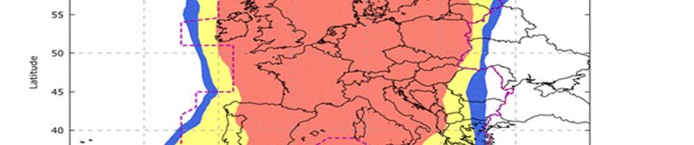
23 2) SBAS The implementation of GNSS and augmentations systems in the MID Region should be in full compliance with ICAO Standards and Recommended Practices and PANS; due to geographic location of some MID States, taking advantages of adjacent SBAS services (EGNOS and GAGAN) is possible. SBAS based procedure do not require any infrastructure at the Airport served, but SBAS elements (e.g. reference stations, master station, satellites) must be in place to support required service level* 2 1 EGNOS Some of MID Region States who are member in the EUROMED* can exploit the use of EGNOS in various applications, mainly in the transport sectors. As of the time of developing this document; five (5) States have officially notified their interest in EGNOS implementation (Algeria, Jordan, Lebanon, Libya, and Tunisia). The requirements to use EGNOS services are as follow: EGNOS Service Maps a) Installation of additionnel RIMS, three RIMS are sufficient to extend the service to EURCOMED States. b) Air Navigation Service Providers have to sign an EGNOS Working Agreement (EWA) with the ESSP (Certified provider of Safety of Life service in aviation in EU ) to be able to activate use of EGNOS SoL. c) International bilateral agreements should be signed between EU and each State to define liability in case of EGNOS failure which results in death/injury/loss/damage to equipment. The current service maps shown in the figures (2 1, 2 2, 2 3 and 2 4), the current availability and continuity for APV I and LPV service level in the MID Region are less than the minimum required signal in space performance specified in Annex 10 Vol. I., the requirements are shown in table (2 2) *Euromed countries (Algeria, Egypt, Jordan, Lebanon, Libya, Morocco, Palestine, Syria and Tunisia). Guidance on GNSS Implementation in the MID Region Page 17
 Figure (2 2)")

24 a) APV I Service Level Figure (2 1) Figure (2 2) Guidance on GNSS Implementation in the MID Region Page 18


25 b) LPV200 Service Level Figure (2 3) Figure (2 4) Guidance on GNSS Implementation in the MID Region Page 19
26 Table (2 2) Guidance on GNSS Implementation in the MID Region Page 20

27 2 2 GAGAN Gulf region falls within the GAGAN GEO footprint as shown in figure (2 5), GCC States can take advantage of GAGAN infrastructure to implement the RNP 0.1 and APV 1 service in the respective states without having the full SBAS infrastructure in their country. Figure(2 5) Its worth to mention that both India and Gulf regions are on equatorial anomaly region. Ionosphere Scintillation is most intense and most frequent in that equatorial region. It can severely affects the performance of SBAS, Therefore, An MLDF (Multi Layer Data Fusion) iono model suitable to serve the equatorial anomaly region was implemented in GAGAN system. The Requirements to use GAGAN as follow: 1 Installing additional reference stations at strategic locations in gulf region and forward the measurements data to GAGAN INMCC, RNP 0.1/APV 1 services can be extended to gulf region. 2 States to notify Indian Airport Authority (IAA) about their interest to use GAGAN Guidance on GNSS Implementation in the MID Region Page 21
28 3 GNSS Application in the MID Region The PBN Implementation plan (ICAO MID Doc 007) documents the applications of GNSS in ICAO Middle East Region. Reference to MID Surveillance plan will be added later 4 GBAS Transition from ILS to GBAS should be based on an economic assessment, an operational assessment and from a safety and security perspective. Cost benefits analysis should be conducted taking on consideration that one GBAS can be used for several runways ends and even in some cases more than one Airports. The standard for GBAS CAT II/III is under development. 5 Cost Benefits Analysis: The use of GNSS in PBN applications reduces the overall running cost of Navigation infrastructure. Also deploying GBAS reduces the cost for ground infrastructure since a single GBAS ground station can provide approach guidance to all runways at an airport. GBAS can increase the Airport capacity, because it does not have sensitive areas that must be protected. However, the CBA is very dependent on specific operational and airport infrastructure aspects. States may consider the following factors during the process of estimating the cost associated with competing alternative in CBA: a) CAPEX a.1 Installation Cost; One GBAS costs around M euro (equal to the cost of 3 ILSs). ILS(s) must be retained to ensure the service continuity during the GNSS/GBAS outage. a.2 Training for operational and technical staff. b) OPEX: c.1 Cost of Flight Check (Calibration). Guidance on GNSS Implementation in the MID Region Page 22
29 c.2 Maintenance costs (Preventive, Reactive, maintenance Contract, less Spare parts). It has been reported by several CBA studies, that GBAS initial investment is higher than for ILS, and lower OPEX. However, Net Present Cost need to be calculated based on Airport infrastructure and operational requirements. 6 Current Use of GBAS/SBAS in the MID Region TBA Guidance on GNSS Implementation in the MID Region Page 23
30 PART III: GNSS VULNERABILITIES 1 Introduction GNSS signals are very weak at the receiver antenna therefore the signal is vulnerable, and also susceptible to ionosphere effects. Current GNSS use a single frequency band common to GPS, GLONASS and SBAS. This makes it easier to intentionally jam GNSS signals. 2 Unintentional Interference Sources There are a number of sources of potential interference to GNSS, including mobile and fixed VHF communications, Solar effect and other sources. The likelihood and operational effect of interference vary with the environment. Unintentional interference is not considered a significant threat provided that States exercise proper control and protection over the electromagnetic spectrum for both existing and new frequency allocations. Furthermore, 2 1 Solar Effect GNSS signals are delayed by varying amounts of time depending on the density of ionized particles (ionosphere) which itself depends on the intensity of solar radiation and other solar energy bursts. The solar activity can cause GNSS service to be degraded or temporarily lost. The type and severity of ionospheric effects vary with the level of solar activity, the region of the world and other factors such as time of year and time of day. Rare solar storms can affect GNSS service over a wide area. The Solar activity peaks happens every eleven years. The availability of a second frequency will allow avionics to calculate ionospheric delay in real time, effectively eliminating a major error source. 2 2 Radio Frequency Interference Harmonics of television stations, certain radars, mobile satellite communications and military systems can cause interference with GNSS signals. Guidance on GNSS Implementation in the MID Region Page 24
31 2 3 On board systems Many reported instances of GNSS interference have been traced to on board systems; such interference can be prevented by installing advanced avionics. 3 Intentional Interference Sources 3 1 Jamming Personal privacy devices (PPDs) have been recognized as being responsible for causing interference to GPS receivers in many occurrences. The intention of PPDs is to protect the privacy of the user so that the user s location is not revealed, therefore the user will not be tracked or monitored. PPDs are low cost jammers to mask GPS signal. 3 2 Spoofing Spoofing is the broadcast of GNSS like signals that cause avionics to calculate erroneous positions and provide false guidance. It is considered that the spoofing of GNSS is less likely than the spoofing of traditional aids because it is technically much more complex. Spoofing of the GBAS data broadcast is virtually impossible, because of an authentication scheme that has been developed. 4 Reducing the Likelihood of Interferences The likelihood of interference depends on such factors as population density and the motivation of individuals or groups in an area to disrupt aviation and non aviation services a) Effective spectrum management, this comprises creating and enforcing regulations/laws that control the use of spectrum and carefully assessing applications for new spectrum allocations. b) The introduction of GNSS signals on new frequencies will ensure that unintentional interference does not cause the complete loss of GNSS service (outage) although enhanced services depending upon the availability of both frequencies might be degraded by such interference Guidance on GNSS Implementation in the MID Region Page 25
32 c) State should develop and enforce a strong regulatory framework governing the use of intentional radiators, including GNSS repeaters, pseudolites, spoofers and jammers, should forbid the use of jamming and spoofing devices and regulate their importation, exportation, manufacture, sale, purchase, ownership and use. d) Multi constellation GNSS would allow the receiver to track more satellites, reducing the likelihood of service disruption. 5 Mitigation Strategies The disruption of GNSS signals will require the application of realistic and effective mitigation strategies to both ensure the safety and regularity of air services and discourage those who would consider disrupting aircraft operations. There are three principal methods which can be applied in combination: a) taking advantage of on board equipment, such as IRS; b) taking advantage of conventional navigation aids and radar; and c) employing procedural (aircrew and/or ATC) methods. Mitigation of GNSS vulnerabilities needs to be balanced in the context of the overall threats to communications, navigation, and surveillance/air traffic management (CNS/ATM) operations to ensure that the applied effort is neither too small (leading to potentially unacceptable risks and/or preventing realization of GNSS enabled benefits) nor too large (in comparison with the effort expended on mitigating other risks). Guidance on GNSS Implementation in the MID Region Page 26
33 References 1 ICAO ANNEX 10, VOL I, Aeronautical Telecommunications. 2 ICAO DOC 9849, Global Navigation Satellite System Manual. First edition, ICAO DOC 8071, Manual on Testing Radio Navigation Aids,, VOL I, 4 ICAO DOC 8071, Manual on Testing Radio Navigation Aids, Volume II Testing of Satellite based Radio Navigation Systems, first edition, ICAO DOC 9750, Global Air Navigation Plan. 6 GNSS Strategy endorsed by MIDANPIRG 15 7 PBN Implementation Plan in ICAO MID Region, First Edition. 8 EGNOS Safety of Life (SoL) Service Definition Document, Version 3.1, 26/9/ McGill University, Paper on the impact of satellite based navigation upon the aviation industry. 10 FAA, AC C, AC90 105A, AC90 101A. 11 Feasibility Studies on Ground Based Augmentation System (GBAS), ASECNA, releases/egnos operational aviation Guidance on GNSS Implementation in the MID Region Page 27
34 APPENDIX A LIST OF NDBs IN THE MID REGION AND PURPOSE OF RETAIN State NDB ID Purpose of retain Plan to remove - END - Guidance on GNSS Implementation in the MID Region Page 28
IMPLEMENTATION OF GNSS BASED SERVICES
 International Civil Aviation Organization IMPLEMENTATION OF GNSS BASED SERVICES Julio Siu Communications, Navigation and Surveillance Regional Officer ICAO NACC Regional Office ICAO Workshop on PBN Airspace
GNSS: CNS Dependencies
 GNSS: CNS Dependencies Lendina Smaja DATM/RDS/NAV 10 March 2015 Agenda The Future Technical Environment GNSS GNSS Supporting CNS Loss of Signal Impact GNSS: CNS Dependencies 2 Original FANS CNS/ATM Concept
ICAO policy on GNSS, GNSS SARPs and global GNSS developments. Jim Nagle Chief, Communication, Navigation and Surveillance Section ICAO
 ICAO policy on GNSS, GNSS SARPs and global GNSS developments Jim Nagle Chief, Communication, Navigation and Surveillance Section ICAO Presentation overview Introduction GNSS developments in ICAO ICAO policy
SBAS solution GCC, Yemen and Iraq System baseline and performance
 SBAS solution GCC, Yemen and Iraq System baseline and performance ACAC Workshop Rabat 7 & 8 November 2017 1 2017 Thales Alenia Space PROPRIETARY C O M MINFORMATION E R C I A L I N THALES C O ALENIA N F
ASSEMBLY 37TH SESSION
 International Civil Aviation Organization WORKING PAPER A37-WP/195 1 22/9/10 (Information paper) ASSEMBLY 37TH SESSION TECHNICAL COMMISSION Agenda Item 35: The Global Air Traffic Management (ATM) System
Radio Navigation Aids Flight Test Seminar
 Radio Navigation Aids Flight Test Seminar FLIGHT INSPECTION IN THE NEW MILLENNIUM Curt Keedy FAA Flight Inspection Policy and Standards Change, Challenge, and Opportunity CHANGES Global Positioning system
ICAO Global Provisions and Regional Developments related to GNSS
 ICAO Global Provisions and Regional Developments related to GNSS Mohamed Smaoui ICAO Deputy Regional Director, Middle East Office, Cairo, Egypt Rabat, Morocco, 7 8 November 2017 OUTLINE Introduction GNSS
INTERNATIONAL CIVIL AVIATION ORGANIZATION
 INTERNATIONAL CIVIL AVIATION ORGANIZATION AFI PLANNING AND IMPLEMENTATION REGIONAL GROUP EIGHTEENTH MEETING (APIRG/18) Kampala, Uganda (27 30 March 2012) Agenda Item 3: Performance Framework for Regional
SATELLITE BASED AUGMENTATION SYSTEM (SBAS) FOR AUSTRALIA
 FOR AUSTRALIA") SATELLITE BASED AUGMENTATION SYSTEM (SBAS) FOR AUSTRALIA AN AIN POSITION PAPER SUBMITTED TO VARIOUS GOVERNMENT DEPARTMENTS BY MR KYM OSLEY AM, CSC, EXEC SECRETARY AIN What are GNSS Augmentation Systems?
SATELLITE BASED AUGMENTATION SYSTEM (SBAS) FOR AUSTRALIA AN AIN POSITION PAPER SUBMITTED TO VARIOUS GOVERNMENT DEPARTMENTS BY MR KYM OSLEY AM, CSC, EXEC SECRETARY AIN What are GNSS Augmentation Systems?
Joint ACAC/ICAO MID WORKSHOP ON GNSS
 Joint ACAC/ICAO MID WORKSHOP ON GNSS Golden Tulip Farah- Rabat (Morocco), 5 April 2016 Joint ACAC/ICAO MID WORKSHOP ON GNSS Golden Tulip Farah- Rabat (Morocco), 5 April 2016 Sessions Session n 1 Session
CONCEPT OF OPERATIONS (CONOPS) FOR DUAL-FREQUENCY MULTI-CONSTELLATION (DFMC) GLOBAL NAVIGATION SATELLITE SYSTEM (GNSS)
 FOR DUAL-FREQUENCY MULTI-CONSTELLATION (DFMC) GLOBAL NAVIGATION SATELLITE SYSTEM (GNSS)") CONCEPT OF OPERATIONS (CONOPS) FOR DUAL-FREQUENCY MULTI-CONSTELLATION (DFMC) GLOBAL NAVIGATION SATELLITE SYSTEM (GNSS) Prepared by the ICAO Navigation Systems Panel CONOPS V6.4 Page 1 of 49 27 April 2018
CONCEPT OF OPERATIONS (CONOPS) FOR DUAL-FREQUENCY MULTI-CONSTELLATION (DFMC) GLOBAL NAVIGATION SATELLITE SYSTEM (GNSS) Prepared by the ICAO Navigation Systems Panel CONOPS V6.4 Page 1 of 49 27 April 2018
REPORT OF COMMITTEE B TO THE CONFERENCE ON AGENDA ITEM 6
 1/10/03 ELEVENTH AIR NAVIGATION CONFERENCE Montreal, 22 September to 3 October 2003 REPORT OF COMMITTEE B TO THE CONFERENCE ON AGENDA ITEM 6 The attached report has been approved by Committee B for submission
GAGAN-Extension to the Gulf Region. Joint ACAC/ICAO MID Workshop on GNSS 7 th & 8 th November 2017
 GAGAN-Extension to the Gulf Region Joint ACAC/ICAO MID Workshop on GNSS 7 th & 8 th November 2017 P.N.S. KUSHWAHA EXECUTIVE DIRECTOR (CNS P) Airports Authority of India New Delhi Topics covered : 1. GAGAN
Final Project Report. Abstract. Document information
 Final Project Report Document information Project Title GNSS Baseline Study Project Number 15.03.04 Project Manager LEONARDO Deliverable Name Final Project Report Deliverable ID D01 Edition 01.02.00 Template
GBAS FOR ATCO. June 2017
 GBAS FOR ATCO June 2017 Disclaimer This presentation is for information purposes only. It should not be relied on as the sole source of information, and should always be used in the context of other authoritative
Aviation Benefits of GNSS Augmentation
 Aviation Benefits of GNSS Augmentation Workshop on the Applications of GNSS Chisinau, Moldova 17-21 May 2010 Jeffrey Auerbach Advisor on GNSS Affairs Office of Space and Advanced Technology U.S. Department
Satellite-Based Augmentation System (SBAS) Integrity Services
 Integrity Services") Satellite-Based Augmentation System (SBAS) Integrity Services Presented To: Munich, Germany Date: March 8, 2010 By: Leo Eldredge, Manager GNSS Group, FAA FAA Satellite Navigation Program 2 Wide Area Augmentation
Satellite-Based Augmentation System (SBAS) Integrity Services Presented To: Munich, Germany Date: March 8, 2010 By: Leo Eldredge, Manager GNSS Group, FAA FAA Satellite Navigation Program 2 Wide Area Augmentation
HORIZONTAL ARAIM AVAILABILITY FOR CIVIL AVIATION OPERATIONS. ARAIM Outreach event
 HORIZONTAL ARAIM AVAILABILITY FOR CIVIL AVIATION OPERATIONS ARAIM Outreach event Moses1978 copyright April 7, 2017 H-ARAIM availability for civil aviation operations 07/04/2017 1 INTRODUCTION Space Segment
GAGAN implementation and certification Programme. Presented by India
 GAGAN implementation and certification Programme Presented by India GPS Aided Geo Augmented Navigation International Civil Aviation Organization (ICAO) Member States Endorsed Global Satellite Navigation
TWELFTH AIR NAVIGATION CONFERENCE
 AN-Conf/12-IP/20 4/10/12 TWELFTH AIR NAVIGATION CONFERENCE Montréal, 19 to 30 November 2012 Agenda Item 1: Strategic issues that address the challenge of integration, interoperability and harmonization
Annex 10 Aeronautical Communications
 Attachment D 3.2.8.1 For Basic GNSS receivers, the receiver qualification standards require demonstration of user positioning accuracy in the presence of interference and a model of selective availability
ELEVENTH AIR NAVIGATION CONFERENCE. Montreal, 22 September to 3 October 2003 TOOLS AND FUNCTIONS FOR GNSS RAIM/FDE AVAILABILITY DETERMINATION
 19/9/03 ELEVENTH AIR NAVIGATION CONFERENCE Montreal, 22 September to 3 October 2003 Agenda Item 6 : Aeronautical navigation issues TOOLS AND FUNCTIONS FOR GNSS RAIM/FDE AVAILABILITY DETERMINATION (Presented
INTEGRITY AND CONTINUITY ANALYSIS FROM GPS JULY TO SEPTEMBER 2016 QUARTERLY REPORT
 INTEGRITY AND CONTINUITY ANALYSIS FROM GPS JULY TO SEPTEMBER 2016 QUARTERLY REPORT Name Responsibility Date Signature Prepared by M Pattinson (NSL) 07/10/16 Checked by L Banfield (NSL) 07/10/16 Authorised
IMPLEMENTATION OF AN SBAS-SACCSA TEST BED IN THE CAR/SAM REGIONS. (Presented by the Secretariat) SUMMARY
 SUMMARY") RLA/03/902 RCC/9 - WP/10 12/06/13 International Civil Aviation Organization South American Regional Office - Project RLA/03/902 Transition to GNSS/SBAS in the CAR/SAM Regions SACCSA Phase III Ninth Meeting
RLA/03/902 RCC/9 - WP/10 12/06/13 International Civil Aviation Organization South American Regional Office - Project RLA/03/902 Transition to GNSS/SBAS in the CAR/SAM Regions SACCSA Phase III Ninth Meeting
Nigerian Communications Satellite Ltd. (NIGCOMSAT)
") OVERVIEW OF NIGERIAN SATELLITE AUGMENTATION SYSTEM COMMENCING WITH PILOT DEMONSTRATION TO VALIDATE NATIONAL WORK PLAN presented by Dr. Lawal Lasisi Salami, NIGERIAN COMMUNICATIONS SATELLITE LTD UNDER FEDERAL
OVERVIEW OF NIGERIAN SATELLITE AUGMENTATION SYSTEM COMMENCING WITH PILOT DEMONSTRATION TO VALIDATE NATIONAL WORK PLAN presented by Dr. Lawal Lasisi Salami, NIGERIAN COMMUNICATIONS SATELLITE LTD UNDER FEDERAL
Performance framework for Regional Air Navigation Planning and Implementation
 GREPECAS/16 WP/21 International Civil Aviation Organization 02/03/11 CAR/SAM Regional Planning and Implementation Group (GREPECAS) Sixteenth Meeting of the CAR/SAM Regional Planning and Implementation
ICAO EUR PERFORMANCE BASED NAVIGATION TASK FORCE & EUROCONTROL RAiSG MEETING (ICAO EUR PBN TF & EUROCONTROL RAiSG)
") PBNTF ECTL-RAISG/2 - WP/05 07/03/2014 ICAO EUR PERFORMANCE BASED NAVIGATION TASK FORCE & EUROCONTROL RAiSG MEETING (ICAO EUR PBN TF & EUROCONTROL RAiSG) SECOND MEETING (Brussels, Belgium, 12-14 March 2014)
PBNTF ECTL-RAISG/2 - WP/05 07/03/2014 ICAO EUR PERFORMANCE BASED NAVIGATION TASK FORCE & EUROCONTROL RAiSG MEETING (ICAO EUR PBN TF & EUROCONTROL RAiSG) SECOND MEETING (Brussels, Belgium, 12-14 March 2014)
AEEC 2013 Presentation to the Airlines and the Aviation Industry
 AEEC 2013 Presentation to the Airlines and the Aviation Industry Multi-Frequency/Multi-Constellation (MFMC) GNSS Receivers Value for Aviation and Airlines John Studenny CMC GPS Product Manager Alain Beaulieu
INTEGRITY AND CONTINUITY ANALYSIS FROM GPS JANUARY TO MARCH 2017 QUARTERLY REPORT
 INTEGRITY AND CONTINUITY ANALYSIS FROM GPS JANUARY TO MARCH 2017 QUARTERLY REPORT Name Responsibility Date Signature Prepared by M Pattinson (NSL) 11/04/17 Checked by L Banfield (NSL) 11/04/17 Authorised
International Programmes & GNSS Monitoring
 International Programmes & GNSS Monitoring Patrizio Vanni (patrizio.vanni@enav.it) GNSS expert ICAO PBN and PANS-OPS Provisions Implementation workshop Lisbon, 26 August 2015 Participation to PBN/GNSS
Protection Augmentation Toughness and Alternatives of GNSS. Melaha 2016 Concord Al-Salam Hotel Cairo, April 25,2016 Refaat Rashad
 Protection Augmentation Toughness and Alternatives of GNSS Melaha 2016 Concord Al-Salam Hotel Cairo, April 25,2016 Refaat Rashad Road Map of the Presentation 1- How Good are GNSS 2- How Vulnerable are
Report of Working Group B: Enhancement of Global Navigation Satellite Systems Services Performance
 Report of : Enhancement of Global Navigation Satellite Systems Services Performance 1. The Working Group on Enhancement of Global Navigation Satellite Systems (GNSS) Service Performance (WG-B) of the International
PRELIMINARY PROGRAMME
 ICG EXPERTS MEETING: GLOBAL NAVIGATION SATELLITE SYSTEMS SERVICES 14-18 December 2015 Vienna International Centre, Vienna, Austria Organized by International Committee on Global Navigation Satellite Systems
GPS/WAAS Program Update
 GPS/WAAS Program Update UN/Argentina Workshop on the Applications of GNSS 19-23 March 2018 Cordoba, Argentina GNSS: A Global Navigation Satellite System of Systems Global Constellations GPS (24+3) GLONASS
Ground Based Augmentation Systems (GBAS) Introduction
 Introduction") Ground Based Augmentation Systems (GBAS) Introduction Technical and Operational Overview Andreas Lipp GBAS Implementation Workshop, ICAO EUR/NAT Paris, 18 March 2010 The European Organisation for the Safety
Ground Based Augmentation Systems (GBAS) Introduction Technical and Operational Overview Andreas Lipp GBAS Implementation Workshop, ICAO EUR/NAT Paris, 18 March 2010 The European Organisation for the Safety
International Programmes & GNSS Monitoring
 International Programmes & GNSS Monitoring Patrizio Vanni (patrizio.vanni@enav.it) GNSS expert ICAO PBN and PANS-OPS Provisions Implementation workshop Minsk, 8 April 2015 ENAV profile Contents BLUEMED
Preparatory paper: food for thought
 CNS SYMPOSIUM 2-3 October 2018 EUROCONTROL s Brussels HQ Preparatory paper: food for thought 1 Introduction EUROCONTROL will host a two-day interactive CNS Symposium on October 2 nd and 3 rd, 2018. This
Special Committee SC-159 Navigation Equipment Using the Global Navigation Satellite System (GNSS) (Version 11)
 (Version 11)") RTCA Paper No. 094-18/PMC-1737 March 22, 2018 TERMS OF REFERENCE Special Committee SC-159 Navigation Equipment Using the Global Navigation Satellite System (GNSS) (Version 11) REQUESTOR: Organization Person
RTCA Paper No. 094-18/PMC-1737 March 22, 2018 TERMS OF REFERENCE Special Committee SC-159 Navigation Equipment Using the Global Navigation Satellite System (GNSS) (Version 11) REQUESTOR: Organization Person
Special Committee SC-159 Navigation Equipment Using the Global Navigation Satellite System (GNSS) (Version 13)
 (Version 13)") RTCA Paper No. 307-18/PMC-1839 December 13, 2018 TERMS OF REFERENCE Special Committee SC-159 Navigation Equipment Using the Global Navigation Satellite System (GNSS) (Version 13) REQUESTOR: Organization
RTCA Paper No. 307-18/PMC-1839 December 13, 2018 TERMS OF REFERENCE Special Committee SC-159 Navigation Equipment Using the Global Navigation Satellite System (GNSS) (Version 13) REQUESTOR: Organization
MIDANPIRG CNS SG/7 Meeting Cairo, Egypt, 31May - 2June 2016
 ARAB REPUBLIC OF EGYPT MIDANPIRG CNS SG/7 Meeting Cairo, Egypt, 31May - 2June 2016 EGYPT CNS Implementation Presented by Khaled Mohamed Reda Ahmed CNS Inspector ANS Engineer 1 ARAB REPUBLIC OF EGYPT Outline
Introduction to PBN and RNP
 Introduction to PBN and RNP Rick Farnworth ATM/RDS/NAV SDM PBN workshop 19 th October 2017 Summary What is PBN? Some History The ICAO PBN Manual The Benefits of PBN Some Examples PBN Approaches PBN and
GAGAN Initiatives Jan 18, 2018
 GAGAN Initiatives Jan 18, 2018 Topics covered 1. Brief profile of GAGAN 2. Features / Accuracy of GAGAN System 3. GAGAN Architecture 4. GAGAN services and Coverage 5. GAGAN utilization in aviation sector
Galileo & EGNOS Programmes Status
 Galileo & EGNOS Programmes Status Ugo Celestino, European Commission EURO-MEDITERRANEAN TRANSPORT FORUM GNSS WORKING GROUP 16 th October 2012 17 October, 2012 The European GNSS Programmes 2 Table of contents
ICAO PBN GO TEAM PBN Implementation Workshop ENAC / ATM
 ICAO PBN GO TEAM PBN Implementation Workshop Minsk, BELARUS, 7-10 April 2015 ENAC / ATM Bertrand FOUCHER 1 PERSONAL BACKGROUND ATCO in Paris Charles de Gaulle ATC Supervisor in Paris Charles de Gaulle,
FOLLOW-UP ON ACTIVITIES OF PROJECT AIR NAVIGATION SYSTEMS IN SUPPORT OF PBN. (Presented by the Secretariat) SUMMARY
 SUMMARY") International Civil Aviation Organization SAM/IG/11-WP/17 South American Regional Office 29/4/13 Eleventh Workshop/Meeting of the SAM Implementation Group (SAM/IG/11) Regional Project RLA/06/901 (Lima,
International Civil Aviation Organization SAM/IG/11-WP/17 South American Regional Office 29/4/13 Eleventh Workshop/Meeting of the SAM Implementation Group (SAM/IG/11) Regional Project RLA/06/901 (Lima,
Final Project Report. Abstract. Document information
 Final Project Report Document information Project Title Multi-constellation GNSS Airborne Navigation Systems Project Number 09.27 Project Manager Thales Avionics Deliverable Name Final Project Report Deliverable
GNSS Spectrum Issues and New GPS L5
 Federal Aviation Administration Washington, D.C. GNSS Spectrum Issues and New GPS L5 International Civil Aviation Organization Regional Coordination Meeting Lima, Peru March 27 28, 2001 Basic GPS System!Space
Regulations. Aeronautical Radio Service
 Regulations Aeronautical Radio Service Version 1.0 Issue Date: 30 December 2009 Copyright 2009 Telecommunications Regulatory Authority (TRA). All rights reserved. P O Box 26662, Abu Dhabi, United Arab
GA and NextGen How technologies like WAAS and ADS-B will change your flying! Presented By Claire Kultgen
 GA and NextGen How technologies like WAAS and ADS-B will change your flying! Presented By Claire Kultgen Overview 1. TIS 2. ADS-B FIS-B TIS-B ADS-R 3. WAAS 4. T-Routes and GPS MEAs Questions Chat Pilot
UNMANNED AIRCRAFT SYSTEMS STUDY GROUP (UASSG)
") 04/09/12 UNMANNED AIRCRAFT SYSTEMS STUDY GROUP (UASSG) TENTH MEETING Rio de Janeiro, 24 to 28 September 2012 Agenda Item 3d: C3 SARPs Command and Control (C2) link provision, link certification and requirement
04/09/12 UNMANNED AIRCRAFT SYSTEMS STUDY GROUP (UASSG) TENTH MEETING Rio de Janeiro, 24 to 28 September 2012 Agenda Item 3d: C3 SARPs Command and Control (C2) link provision, link certification and requirement
CONSIDERATIONS FOR GNSS MEASUREMENTS
 CONSIDERATIONS FOR GNSS MEASUREMENTS Cornel PĂUNESCU 1, Cristian VASILE 2, Cosmin CIUCULESCU 3 1 PhD University of Bucharest, e-mail: cornelpaun@gmail.com 2 Lecturer PhD University of Craiova, cristi_vasile_4you@yahoo.com
Indian Regional Navigation Satellite System (IRNSS) / Navigation with Indian Constellation (NavIC) and GPS Aided Geo Augmented Navigation (GAGAN)
 / Navigation with Indian Constellation (NavIC) and GPS Aided Geo Augmented Navigation (GAGAN)") Indian Regional Navigation Satellite System (IRNSS) / Navigation with Indian Constellation (NavIC) and GPS Aided Geo Augmented Navigation (GAGAN) IRNSS-1A Gsat-8 IRNSS 7 November, 2016 Nilesh M. Desai
Indian Regional Navigation Satellite System (IRNSS) / Navigation with Indian Constellation (NavIC) and GPS Aided Geo Augmented Navigation (GAGAN) IRNSS-1A Gsat-8 IRNSS 7 November, 2016 Nilesh M. Desai
Horizontal Advanced RAIM: Operational Benefits and Future Challenges
 Horizontal Advanced RAIM: Operational Benefits and Future Challenges International Technical Symposium on Navigation and Timing 2015 Session Air Navigation November 2015 Toulouse/France 1 ICAO ABAS augmentation
Report of the Working Group B: Enhancement of Global Navigation Satellite Systems (GNSS) Services Performance
 Services Performance") Report of the Working Group B: Enhancement of Global Navigation Satellite Systems (GNSS) Services Performance 1. The Working Group on Enhancement of Global Navigation Satellite Systems (GNSS) Service Performance
Report of the Working Group B: Enhancement of Global Navigation Satellite Systems (GNSS) Services Performance 1. The Working Group on Enhancement of Global Navigation Satellite Systems (GNSS) Service Performance
ELECTRONIC BULLETIN For information only
 International Civil Aviation Organization ELECTRONIC BULLETIN For information only EB 2011/56 AN 7/5 21 November 2011 INTERFERENCE TO GLOBAL NAVIGATION SATELLITE SYSTEM (GNSS) SIGNALS 1. Aviation operations
SBAS DFMC performance analysis with the SBAS DFMC Service Volume software Prototype (DSVP)
") SBAS DFMC performance analysis with the SBAS DFMC Service Volume software Prototype (DSVP) D. Salos, M. Mabilleau, Egis Avia C. Rodriguez, H. Secretan, N. Suard, CNES (French Space Agency) Email: Daniel.salos@egis.fr
SBAS DFMC performance analysis with the SBAS DFMC Service Volume software Prototype (DSVP) D. Salos, M. Mabilleau, Egis Avia C. Rodriguez, H. Secretan, N. Suard, CNES (French Space Agency) Email: Daniel.salos@egis.fr
PBN Operational Approval Course
 PBN Operational Approval Course Introduction and Overview PBN Operations Approval Welcome Logistics Introductions PBN Overview 2 Instructor Bob Kennedy Attendees: 3 Course Objectives The objective of this
Lecture-1 CHAPTER 2 INTRODUCTION TO GPS
 Lecture-1 CHAPTER 2 INTRODUCTION TO GPS 2.1 History of GPS GPS is a global navigation satellite system (GNSS). It is the commonly used acronym of NAVSTAR (NAVigation System with Time And Ranging) GPS (Global
CHIPS Technology Roadmap February 2012 VERSION 1.0
 CHIPS Technology Roadmap February 2012 VERSION 1.0 circulation 150 copyright skyguide - swiss air navigation services ltd design confident gmbh CHIPS Technology Roadmap February 2012 Version 1.0 CH-wide
ICG GNSS Interoperability Workshop A Civil Aviation Perspective
 Approved for Public Release; Distribution Unlimited. 13-1907. ICG GNSS Interoperability Workshop A Civil Aviation Perspective C h r i s t o p h e r J. H e g a r t y A p r i l 2 0 1 3 Disclaimer: The contents
Regional and Inter-Regional Seminar and Workshop on Search and Rescue
 Regional and Inter-Regional Seminar and Workshop on Search and Rescue Mahe, Seychelles 19-22 July 2016 1 Agenda Aireon Introduction Space-Based ADS-B Overview Aireon System Deployment Status Aireon ALERT
ICAO SARPS AND GUIDANCE DOCUMENTS ON SURVEILLANCE SYSTEMS
 ICAO SARPS AND GUIDANCE DOCUMENTS ON SURVEILLANCE SYSTEMS MEETING/WORKSHOP ON AUTOMATIC DEPENDENT SURVEILLANCE BROADCAST (ADS B) IMPLEMENTATION (ADS B/IMP) (Lima, Peru, 13 to 16 November 2017) ONOFRIO
A Review of Vulnerabilities of ADS-B
 A Review of Vulnerabilities of ADS-B S. Sudha Rani 1, R. Hemalatha 2 Post Graduate Student, Dept. of ECE, Osmania University, 1 Asst. Professor, Dept. of ECE, Osmania University 2 Email: ssrani.me.ou@gmail.com
International Civil Aviation Organization. Sixth Meeting of CNS/MET Sub-Group of APANPIRG. Bangkok, Thailand July 2002
 International Civil Aviation Organization CNS/MET/SG/6-WP/27 (Revised) Sixth Meeting of CNS/MET Sub-Group of APANPIRG Bangkok, Thailand 15-19 July 2002 Agenda Item 6: Review: a) Strategy for the provision
European Geostationary Navigation Overlay Service (EGNOS) Capability on Sirius 5 Satellite for SES
 Capability on Sirius 5 Satellite for SES") 21 October 2009 SES SIRIUS European Geostationary Navigation Overlay Service (EGNOS) Capability on Sirius 5 Satellite for SES Mike Pavloff, Executive Director, Space Systems/Loral Information included
21 October 2009 SES SIRIUS European Geostationary Navigation Overlay Service (EGNOS) Capability on Sirius 5 Satellite for SES Mike Pavloff, Executive Director, Space Systems/Loral Information included
Sixth Meeting of CNS/MET Sub-Group of APANPIRG. Bangkok, Thailand, July 2002
 International Civil Aviation Organization CNS/MET/SG/6-IP/2 Sixth Meeting of CNS/MET Sub-Group of APANPIRG Bangkok, Thailand, 15 19 July 2002 Agenda Item 6: Review: a) Strategy for the provision of Precision
EC UA Aviation Conference, Windhoek, Namibia, April 2 & 3, 2009
 EC UA Aviation Conference, Windhoek, Namibia, April 2 & 3, 2009 Session 7 : EU-Africa Civil Aviation Co-operation 1 Contents Page 2 Who is Thales Alenia Space Thales Alenia Space contribution to Air Traffic
Indian GNSS Industry Overview Challenges and future prospects
 Indian GNSS Industry Overview Challenges and future prospects Expert Presentation By Dr. S.V. Kibe Consultant, SATCOM & GNSS, Bangalore, India (Former Programme Director, SATNAV,ISRO HQ) On February 20,2013
PBN fleet equipage according to FPL content. Michel ROELANDT
 PBN fleet equipage according to FPL content Michel ROELANDT EUROCONTROL RAiSG/PBN TF Meeting March 2014 Introduction 15 Nov 2012: standard ICAO format for airline flight plans changed. New fields have
SPECIAL EFFECTS OF THE REGIONAL SATELLITE AUGMENTATION SYSTEM (RSAS)
") St. D. Ilcev (Mangosuthu University of Technology (MUT) South Africa) SPECIAL EFFECTS OF THE REGIONAL SATELLITE AUGMENTATION SYSTEM (RSAS) This paper introduces the special effects of the new developed
St. D. Ilcev (Mangosuthu University of Technology (MUT) South Africa) SPECIAL EFFECTS OF THE REGIONAL SATELLITE AUGMENTATION SYSTEM (RSAS) This paper introduces the special effects of the new developed
Challenges and Solutions for GPS Receiver Test
 Challenges and Solutions for GPS Receiver Test Presenter: Mirin Lew January 28, 2010 Agenda GPS technology concepts GPS and GNSS overview Assisted GPS (A-GPS) Basic tests required for GPS receiver verification
Implications of GNSS SiS Disruption on Safety of PBN Operations Risks, Solutions and Steps Forward
 Implications of GNSS SiS Disruption on Safety of PBN Operations Risks, Solutions and Steps Forward Non-Intentional & Intentional RFI of the GNSS SiS Silvio Semanjski - Content GNSS SiS disruption - Extent
Navigation Programs Strategy
 Change History Revision Effective Sections Changes Made Date Affected 1.0 01/12/2018 Initial Release ii Preface This Navigation Programs Strategy document contains the FAA s plan to provide navigation
AREA NAVIGATION SYSTEMS
 AREA NAVIGATION SYSTEMS 1. Introduction RNAV is defined as a method of navigation which permits aircraft operation on any desired flight path within the coverage of station-referenced navigation aids or
RESPONSE TO THE HOUSE OF COMMONS TRANSPORT SELECT COMMITTEE INQUIRY INTO GALILEO. Memorandum submitted by The Royal Academy of Engineering
 RESPONSE TO THE HOUSE OF COMMONS TRANSPORT SELECT COMMITTEE INQUIRY INTO GALILEO Memorandum submitted by The Royal Academy of Engineering September 2004 Executive Summary The Royal Academy of Engineering
GNSS Programme. Overview and Status in Europe
 GNSS Programme Overview and Status in Europe Inaugural Forum Satellite Positioning Research and Application Center 23 April 2007 Tokyo Presented by Thomas Naecke (European Commission) Prepared by Daniel
Overview of GNSS Navigation Sources, Augmentation Systems, and Applications
 Overview of GNSS Navigation Sources, Augmentation Systems, and Applications The Ionosphere and its Effects on GNSS Systems 14 to 16 April 2008 Santiago, Chile Dr. S. Vincent Massimini Global Navigation
The MEDUSA experience: the case study of Tunisia
 The MEDUSA experience: the case study of Tunisia Euromed GNSS II project/medusa Final event on GNSS for aviation Antonella Di Fazio, MEDUSA key expert/team leader antonella.difazio@telespazio.com MEDUSA
EGNOS Operations Oper and T and heir T Planned Ev E olution v
 EGNOS Operations a Th P Evo EGNOS Laurent Gauthier, Javier Ventura-Traveset, Felix Toran Navigation Department, ESA Directorate of European Union and Industrial Programmes, Toulouse, France Chantal de
RESOLUTION MSC.401(95) (Adopted on 8 June 2015) PERFORMANCE STANDARDS FOR MULTI-SYSTEM SHIPBORNE RADIONAVIGATION RECEIVERS
 (Adopted on 8 June 2015) PERFORMANCE STANDARDS FOR MULTI-SYSTEM SHIPBORNE RADIONAVIGATION RECEIVERS") ANNEX 17 MSC 95/22/Add.2 Annex 17, page 1 THE MARITIME SAFETY COMMITTEE, RECALLING Article 28(b) of the Convention on the International Maritime Organization concerning the functions of the Committee,
ANNEX 17 MSC 95/22/Add.2 Annex 17, page 1 THE MARITIME SAFETY COMMITTEE, RECALLING Article 28(b) of the Convention on the International Maritime Organization concerning the functions of the Committee,
Een GPS naderingshulpmiddel voor de kleine luchtvaart
 Technische ontwikkelingen: Een GPS naderingshulpmiddel voor de kleine luchtvaart Christian Tiberius Faculteit Luchtvaart- en Ruimtevaarttechniek TU Delft WORKSHOP Is er nog Lucht(ruim) voor de Kleine Luchtvaart
Modern ARINC 743B DO-229D and DO-253C GLSSU Solutions For Retrofit
 Commercial Aviation Modern ARINC 743B DO-229D and DO-253C GLSSU Solutions For Retrofit Presented to AEEC March 2010 The Classic Retrofit Challenge Financial: Operating budget year financing ROI payback:
Wide Area Augmentation System (WAAS)
") Wide Area Augmentation System (WAAS) Ionospheric Effects Symposium By: Jason Burns Technology Evolution Lead Date: Agenda WAAS Overview Ionospheric Effects on WAAS Future Plans User Segment Update 2 WAAS
Wide Area Augmentation System (WAAS) Ionospheric Effects Symposium By: Jason Burns Technology Evolution Lead Date: Agenda WAAS Overview Ionospheric Effects on WAAS Future Plans User Segment Update 2 WAAS
International Civil Aviation Organization THE SIXTH MEETING OF IONOSPHERIC STUDIES TASK FORCE (ISTF/6) OUTCOME OF THE NSP/2 MEETING
 OUTCOME OF THE NSP/2 MEETING") ISTF/6 WP/06 Agenda Item 2 15/01/16 International Civil Aviation Organization THE SIXTH MEETING OF IONOSPHERIC STUDIES TASK FORCE (ISTF/6) Bangkok, Thailand, 19 21 January 2016 Agenda Item 2: Review of
ISTF/6 WP/06 Agenda Item 2 15/01/16 International Civil Aviation Organization THE SIXTH MEETING OF IONOSPHERIC STUDIES TASK FORCE (ISTF/6) Bangkok, Thailand, 19 21 January 2016 Agenda Item 2: Review of
School of Civil & Environmental Engineering, UNSW, Sydney, Australia. Chris Rizos. President Australian Institute of Navigation
 The Threat to Space Based Service (for PNT applications) School of Civil & Environmental Engineering, UNSW, Sydney, Australia Chris Rizos President Australian Institute of Navigation Outline GNSS... a
European GNSS: Galileo and EGNOS for next generation Road Charging
 European GNSS: Galileo and EGNOS for next generation Road Charging 20 th October 2014 Gian Gherardo Calini European GNSS Agency (GSA) GNSS have made a huge impact in our society it is key in Road transportation
RAIM Availability prediction
 RAIM Availability prediction Main content 一 Background & research purposes 二 Related research in China and abroad 三 Theory and arithmetic 四 RAIM systems development 五 The vision of the future 1 Background
Operating on the Radio Frequency of 1090 Megahertz (MHz)
") Deviation Request #107 for an ETSO approval for CS ETSO applicable to Extended Squitter Automatic Dependent Surveillance Broadcast (ADS B) and Traffic Information Service Broadcast (TIS B) Equipment Operating
Deviation Request #107 for an ETSO approval for CS ETSO applicable to Extended Squitter Automatic Dependent Surveillance Broadcast (ADS B) and Traffic Information Service Broadcast (TIS B) Equipment Operating
APPENDIX C VISUAL AND NAVIGATIONAL AIDS
 VISUAL AND NAVIGATIONAL AIDS APPENDIX C VISUAL AND NAVIGATIONAL AIDS An integral part of the airport system is the visual and navigational aids provided to assist pilots in navigating both on the airfield
GNSS-based Flight Inspection Systems
 GNSS-based Flight Inspection Systems Euiho Kim, Todd Walter, and J. David Powell Department of Aeronautics and Astronautics Stanford University Stanford, CA 94305, USA Abstract This paper presents novel
GPS with RAIM or EGNOS? The difference for (mountainous) helicopter operations. Marc Troller Skyguide / CNS expert group
 helicopter operations. Marc Troller Skyguide / CNS expert group") GPS with RAIM or EGNOS? The difference for (mountainous) helicopter operations Marc Troller Skyguide / CNS expert group 1 Motivation for Dedicated Helicopter Procedures Swiss GNSS LFN network: Mandate
GPS with RAIM or EGNOS? The difference for (mountainous) helicopter operations Marc Troller Skyguide / CNS expert group 1 Motivation for Dedicated Helicopter Procedures Swiss GNSS LFN network: Mandate
One Source for Positioning Success
 novatel.com One Source for Positioning Success RTK, PPP, SBAS OR DGNSS. NOVATEL CORRECT OPTIMIZES ALL CORRECTION SOURCES, PUTTING MORE POWER, FLEXIBILITY AND CONTROL IN YOUR HANDS. NovAtel CORRECT is the
The Effect of Radio Frequency Interference on GNSS Signals and Mitigation Techniques Presented by Dr. Tarek Attia
 International Conference and Exhibition Melaha2016 GNSS WAY Ahead 25-27 April2016, Cairo, Egypt The Effect of Radio Frequency Interference on GNSS Signals and Mitigation Techniques Presented by Dr. Tarek
Contextual note SESAR Solution description form for deployment planning
 Purpose: Release 5 SESAR Solution ID #114 Contextual note SESAR Solution description form for deployment planning This contextual note introduces a SESAR Solution (for which maturity has been assessed
The Wide Area Augmentation System
 The Wide Area Augmentation System Stanford University http://waas.stanford.edu What is Augmentation? 2 Add to GNSS to Enhance Service Improve integrity via real time monitoring Improve availability and
EGNOS Safety of Life (SoL) Service Definition Document
 Service Definition Document") EGNOS Safety of Life (SoL) Service Definition Document DOCUMENT CHANGE RECORD Revision Date Summary of changes 1.0 02/03/2011 First release of the document 2.0 28/06/2013 Update of the document including
EGNOS Safety of Life (SoL) Service Definition Document DOCUMENT CHANGE RECORD Revision Date Summary of changes 1.0 02/03/2011 First release of the document 2.0 28/06/2013 Update of the document including
On Location at Stanford University
 Thank you for inviting me (back) to Deutsches Zentrum für Luft- und Raumfahrt On Location at Stanford University by Per Enge (with the help of many) July 27, 2009 My thanks to the Federal Aviation Administration
ARAIM Fault Detection and Exclusion
 ARAIM Fault Detection and Exclusion Boris Pervan Illinois Institute of Technology Chicago, IL November 16, 2017 1 RAIM ARAIM Receiver Autonomous Integrity Monitoring (RAIM) uses redundant GNSS measurements
An advisory circular may also include technical information that is relevant to the standards or requirements.
 Advisory Circular AC91-24 Automatic Dependent Surveillance Broadcast (ADS-B) Systems Revision 0 24 July 2018 General Civil Aviation Authority advisory circulars contain guidance and information about standards,
Latest Evolution of RAIM Prediction Systems
 Latest Evolution of RAIM Prediction Systems SPACEKEYS is a project funded by the European Space Agency SPACEKEYS 2018. All rights reserved. Topics Rationale Requirements Objectives Results Achievements