GNSS Spectrum Issues and New GPS L5
|
|
|
- Frederica Austin
- 5 years ago
- Views:
Transcription


1 Federal Aviation Administration Washington, D.C. GNSS Spectrum Issues and New GPS L5 International Civil Aviation Organization Regional Coordination Meeting Lima, Peru March 27 28, 2001

2 Basic GPS System!Space Segment!24 Satellites!6 Orbital Planes!4 Satellites per Plane!Orbit at Approximately 11,000 Nautical Miles Above the Earth!Orbits Every 12 Hours!Ground Control Segment!Master Control Station, Colorado Springs!5 Monitor Stations at Worldwide Locations 2

3 GPS Approved for Supplemental Means of Navigation 3
4 GPS Service! Standard Positioning Service!Worldwide Coverage!Civil Use at no charge!c/a Code on L1 Frequency ( MHz)!Accuracy meters horizontal & 156 meters vertical, with 95% Availability!Second civil frequency ( MHz) available 2003!Will be available for general use in non-safety-critical applications.!third civil frequency ( MHz) available 2005!Will meet the needs of critical safety-of-life applications such as civil aviation. 4

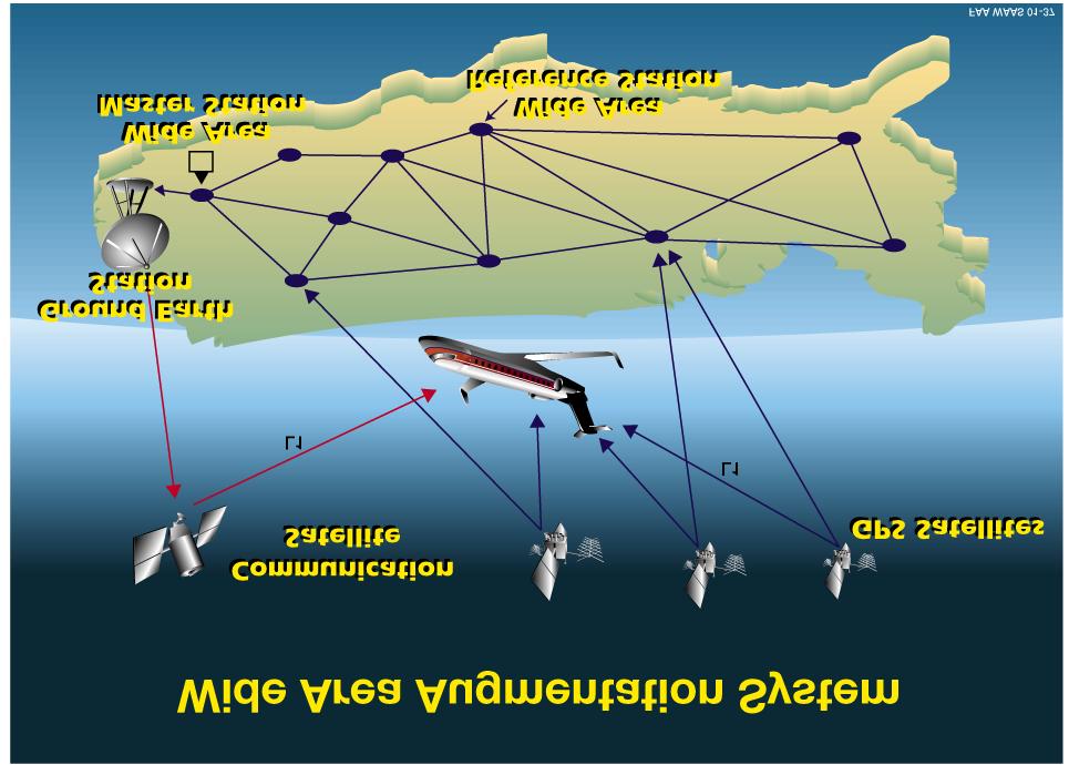
5 Satellite Navigation s Mission SBAS/GBAS Implementation 5
6 FAA

7 Ground Based Augmentation System (GBAS) Architecture Pseudolite Pseudolite Pseudolite Processor GPS Receiver VHF Transmitter Monitor Status LAAS Reference Station (Integrity Accuracy Availability) 7

8 Potential Benefits of GBAS Category II & III - Precision Approach Capability Remote Coverage - Available to Areas Not Covered by SBAS Tailored Approaches - To Avoid Obstacles, Noise Sensitive Areas, or Congested Airspace Multiple Runway Coverage - One GBAS Will Serve the Entire Airport Aircraft Surface Navigation - Aircraft Can Use GBAS as a Guide When Taxiing 8
9 Modernization of GPS Element of GNSS! GPS L2 signal, at MHz, will be made available for non-safety-critical applications. Available on satellites launching in 2003.! A new civil GPS (L5) signal, at MHz, will be made available for critical safety-of-life applications. Goal is to implement L5 on satellites launching in 2005.! Enhances availability and continuity to improve service to users. 9
10 Future GPS Frequency Plan L5 L2 L MHz MHz MHz ARNS/RNSS (see note) RNSS RADIOLOCATION Radiolocation Amateur ARNS/RNSS NOTE: At WRC-2000, a new primary allocation for RNSS in the MHz band was approved. This will accommodate the new L5 frequency and planned Galileo system for safety-of-life applications. 10
11 Benefits of a New GNSS Signal! Improved Safety benefit! Reduce the possibility of Controlled Flight into Terrain (CFIT)! Global Precision Approach capability will be the key mitigation for CFIT! Improved surface surveillance capability! Reduction in Runway Incursions! Completely redundant satellite navigation service to L1! L5 will be implemented on both GPS and WAAS satellites! Will Increase likelihood that international civil aviation can adopt sole-means and sole-service provider approach with satellite navigation! Increased efficiency! Reductions in en route separations (both lateral and vertical)! Improved ADS-B capability 11
12 Interference! The addition of another ARNS-protected GPS signal (L5 at MHz) will greatly increase protection against interference! This critical point was underscored in a GPS Risk Assessment Study performed by Johns Hopkins University Applied Physics Laboratory! second civil frequency, and the proposed higher signal power, will mitigate interference concerns! Study was co-sponsored by ATA, AOPA, and FAA! Likelihood that unintentional interference would affect flight operations is significantly reduced (i.e., the probability that both L1 and L5 would be simultaneously interfered with unintentionally is very low)! FAA is still actively assessing the threat of intentional interference to civil aviation operations 12
13 Summary The ICAO GNSS continues to be modernized and improved to provide added safety benefits and operational enhancements for international civil aviation 13
Radio Navigation Aids Flight Test Seminar
 Radio Navigation Aids Flight Test Seminar FLIGHT INSPECTION IN THE NEW MILLENNIUM Curt Keedy FAA Flight Inspection Policy and Standards Change, Challenge, and Opportunity CHANGES Global Positioning system
Aviation Benefits of GNSS Augmentation
 Aviation Benefits of GNSS Augmentation Workshop on the Applications of GNSS Chisinau, Moldova 17-21 May 2010 Jeffrey Auerbach Advisor on GNSS Affairs Office of Space and Advanced Technology U.S. Department
GBAS FOR ATCO. June 2017
 GBAS FOR ATCO June 2017 Disclaimer This presentation is for information purposes only. It should not be relied on as the sole source of information, and should always be used in the context of other authoritative
Special Committee SC-159 Navigation Equipment Using the Global Navigation Satellite System (GNSS) (Version 13)
 (Version 13)") RTCA Paper No. 307-18/PMC-1839 December 13, 2018 TERMS OF REFERENCE Special Committee SC-159 Navigation Equipment Using the Global Navigation Satellite System (GNSS) (Version 13) REQUESTOR: Organization
RTCA Paper No. 307-18/PMC-1839 December 13, 2018 TERMS OF REFERENCE Special Committee SC-159 Navigation Equipment Using the Global Navigation Satellite System (GNSS) (Version 13) REQUESTOR: Organization
Special Committee SC-159 Navigation Equipment Using the Global Navigation Satellite System (GNSS) (Version 11)
 (Version 11)") RTCA Paper No. 094-18/PMC-1737 March 22, 2018 TERMS OF REFERENCE Special Committee SC-159 Navigation Equipment Using the Global Navigation Satellite System (GNSS) (Version 11) REQUESTOR: Organization Person
RTCA Paper No. 094-18/PMC-1737 March 22, 2018 TERMS OF REFERENCE Special Committee SC-159 Navigation Equipment Using the Global Navigation Satellite System (GNSS) (Version 11) REQUESTOR: Organization Person
ICAO policy on GNSS, GNSS SARPs and global GNSS developments. Jim Nagle Chief, Communication, Navigation and Surveillance Section ICAO
 ICAO policy on GNSS, GNSS SARPs and global GNSS developments Jim Nagle Chief, Communication, Navigation and Surveillance Section ICAO Presentation overview Introduction GNSS developments in ICAO ICAO policy
APPENDIX C VISUAL AND NAVIGATIONAL AIDS
 VISUAL AND NAVIGATIONAL AIDS APPENDIX C VISUAL AND NAVIGATIONAL AIDS An integral part of the airport system is the visual and navigational aids provided to assist pilots in navigating both on the airfield
RESULTS OF THE REGIONAL SBAS TEST BED TYPE WAAS PROYECT RLA/00/009. Onofrio Smarrelli ICAO SAM CNS Lima Regional Office
 WORKSHOP / SEMINAR FOR THE IMPLEMENTATION OF NAVIGATION INFRASTRUCTURE TO SUPPORT PBN AND GNSS PRECISION APPROACH OPERATIONS IN THE NAM CAR SAM REGION (Lima, Peru 15 to 17 August 2016 ) RESULTS OF THE
GNSS: CNS Dependencies
 GNSS: CNS Dependencies Lendina Smaja DATM/RDS/NAV 10 March 2015 Agenda The Future Technical Environment GNSS GNSS Supporting CNS Loss of Signal Impact GNSS: CNS Dependencies 2 Original FANS CNS/ATM Concept
Satellite-Based Augmentation System (SBAS) Integrity Services
 Integrity Services") Satellite-Based Augmentation System (SBAS) Integrity Services Presented To: Munich, Germany Date: March 8, 2010 By: Leo Eldredge, Manager GNSS Group, FAA FAA Satellite Navigation Program 2 Wide Area Augmentation
Satellite-Based Augmentation System (SBAS) Integrity Services Presented To: Munich, Germany Date: March 8, 2010 By: Leo Eldredge, Manager GNSS Group, FAA FAA Satellite Navigation Program 2 Wide Area Augmentation
ELECTRONIC BULLETIN For information only
 International Civil Aviation Organization ELECTRONIC BULLETIN For information only EB 2011/56 AN 7/5 21 November 2011 INTERFERENCE TO GLOBAL NAVIGATION SATELLITE SYSTEM (GNSS) SIGNALS 1. Aviation operations
GPS/WAAS Program Update
 GPS/WAAS Program Update UN/Argentina Workshop on the Applications of GNSS 19-23 March 2018 Cordoba, Argentina GNSS: A Global Navigation Satellite System of Systems Global Constellations GPS (24+3) GLONASS
Spectrum Management: Policy and Regulatory Models
 Spectrum Management: Policy and Regulatory Models American Meteorological Society Policy Program May 25, 2016 Scott Pace George Washington University Space Policy Institute Washington, D.C. GPS enables
WRC-12 Implications for Terrestrial Services other than Mobile Broadband. John Mettrop BDT Expert. Scope
 WRC-12 Implications for Terrestrial Services other than Mobile Broadband John Mettrop BDT Expert Scope Areas addressed Aeronautical Amateur Maritime Radiodetermination Public protection & disaster relief
TWELFTH AIR NAVIGATION CONFERENCE
 AN-Conf/12-IP/20 4/10/12 TWELFTH AIR NAVIGATION CONFERENCE Montréal, 19 to 30 November 2012 Agenda Item 1: Strategic issues that address the challenge of integration, interoperability and harmonization
Nigerian Communications Satellite Ltd. (NIGCOMSAT)
") OVERVIEW OF NIGERIAN SATELLITE AUGMENTATION SYSTEM COMMENCING WITH PILOT DEMONSTRATION TO VALIDATE NATIONAL WORK PLAN presented by Dr. Lawal Lasisi Salami, NIGERIAN COMMUNICATIONS SATELLITE LTD UNDER FEDERAL
OVERVIEW OF NIGERIAN SATELLITE AUGMENTATION SYSTEM COMMENCING WITH PILOT DEMONSTRATION TO VALIDATE NATIONAL WORK PLAN presented by Dr. Lawal Lasisi Salami, NIGERIAN COMMUNICATIONS SATELLITE LTD UNDER FEDERAL
Automatic Dependent Surveillance -ADS-B
 ASECNA Workshop on ADS-B (Dakar, Senegal, 22 to 23 July 2014) Automatic Dependent Surveillance -ADS-B Presented by FX SALAMBANGA Regional Officer, CNS WACAF OUTLINE I Definition II Principles III Architecture
A Review of Vulnerabilities of ADS-B
 A Review of Vulnerabilities of ADS-B S. Sudha Rani 1, R. Hemalatha 2 Post Graduate Student, Dept. of ECE, Osmania University, 1 Asst. Professor, Dept. of ECE, Osmania University 2 Email: ssrani.me.ou@gmail.com
IMPLEMENTATION OF GNSS BASED SERVICES
 International Civil Aviation Organization IMPLEMENTATION OF GNSS BASED SERVICES Julio Siu Communications, Navigation and Surveillance Regional Officer ICAO NACC Regional Office ICAO Workshop on PBN Airspace
ASSEMBLY 37TH SESSION
 International Civil Aviation Organization WORKING PAPER A37-WP/195 1 22/9/10 (Information paper) ASSEMBLY 37TH SESSION TECHNICAL COMMISSION Agenda Item 35: The Global Air Traffic Management (ATM) System
SBAS solution GCC, Yemen and Iraq System baseline and performance
 SBAS solution GCC, Yemen and Iraq System baseline and performance ACAC Workshop Rabat 7 & 8 November 2017 1 2017 Thales Alenia Space PROPRIETARY C O M MINFORMATION E R C I A L I N THALES C O ALENIA N F
Use of Satellite-based Technologies to Enhance safety and efficiency in ATC and Airport Operation
 Use of Satellite-based Technologies to Enhance safety and efficiency in ATC and Airport Operation Presented by Felix Tsao Senior Electronics Engineer Civil Aviation Department 26 May 2017 1 Briefing on
CONSIDERATIONS FOR GNSS MEASUREMENTS
 CONSIDERATIONS FOR GNSS MEASUREMENTS Cornel PĂUNESCU 1, Cristian VASILE 2, Cosmin CIUCULESCU 3 1 PhD University of Bucharest, e-mail: cornelpaun@gmail.com 2 Lecturer PhD University of Craiova, cristi_vasile_4you@yahoo.com
SATELLITE BASED AUGMENTATION SYSTEM (SBAS) FOR AUSTRALIA
 FOR AUSTRALIA") SATELLITE BASED AUGMENTATION SYSTEM (SBAS) FOR AUSTRALIA AN AIN POSITION PAPER SUBMITTED TO VARIOUS GOVERNMENT DEPARTMENTS BY MR KYM OSLEY AM, CSC, EXEC SECRETARY AIN What are GNSS Augmentation Systems?
SATELLITE BASED AUGMENTATION SYSTEM (SBAS) FOR AUSTRALIA AN AIN POSITION PAPER SUBMITTED TO VARIOUS GOVERNMENT DEPARTMENTS BY MR KYM OSLEY AM, CSC, EXEC SECRETARY AIN What are GNSS Augmentation Systems?
RECOMMENDATION ITU-R M.1639 *
 Rec. ITU-R M.1639 1 RECOMMENDATION ITU-R M.1639 * Protection criterion for the aeronautical radionavigation service with respect to aggregate emissions from space stations in the radionavigation-satellite
Future use of the band MHz
 Future use of the band 5030-5150 MHz Template reference : 100182080O-EN Compatibility analysis between existing AMS(R)S and ARNS/MLS allocations NSP/SSG, Montreal, 31 March - 4 April 2008, agenda Item
GPS with RAIM or EGNOS? The difference for (mountainous) helicopter operations. Marc Troller Skyguide / CNS expert group
 helicopter operations. Marc Troller Skyguide / CNS expert group") GPS with RAIM or EGNOS? The difference for (mountainous) helicopter operations Marc Troller Skyguide / CNS expert group 1 Motivation for Dedicated Helicopter Procedures Swiss GNSS LFN network: Mandate
GPS with RAIM or EGNOS? The difference for (mountainous) helicopter operations Marc Troller Skyguide / CNS expert group 1 Motivation for Dedicated Helicopter Procedures Swiss GNSS LFN network: Mandate
Subject: Aeronautical Telecommunications Aeronautical Radio Frequency Spectrum Utilization
 GOVERNMENT OF INDIA OFFICE OF DIRECTOR GENERAL OF CIVIL AVIATION TECHNICAL CENTRE, OPP SAFDARJANG AIRPORT, NEW DELHI CIVIL AVIATION REQUIREMENTS SECTION 4 - AERODROME STANDARDS & AIR TRAFFIC SERVICES SERIES
: Frequencies for new aeronautical Communication systems
 Date : 9 November 2001 Subject Origin Status : : : Very preliminary draft EXECUTIVE SUMMARY This paper provides information on the additional radio spectrum capacity necessary for the aviation community
Wide Area Augmentation System (WAAS)
") Wide Area Augmentation System (WAAS) Ionospheric Effects Symposium By: Jason Burns Technology Evolution Lead Date: Agenda WAAS Overview Ionospheric Effects on WAAS Future Plans User Segment Update 2 WAAS
Wide Area Augmentation System (WAAS) Ionospheric Effects Symposium By: Jason Burns Technology Evolution Lead Date: Agenda WAAS Overview Ionospheric Effects on WAAS Future Plans User Segment Update 2 WAAS
REPORT OF COMMITTEE B TO THE CONFERENCE ON AGENDA ITEM 6
 1/10/03 ELEVENTH AIR NAVIGATION CONFERENCE Montreal, 22 September to 3 October 2003 REPORT OF COMMITTEE B TO THE CONFERENCE ON AGENDA ITEM 6 The attached report has been approved by Committee B for submission
Alternate Position, Navigation & Time APNT for Civil Aviation
 Alternate Position, Navigation & Time APNT for Civil Aviation For Working Group B of the International GNSS Committee Shanghai, May 2011 by Per Enge & Leo Eldredge Work supported by the Federal Aviation
Future Aeronautical Communication System - FCI
 Future Aeronautical Communication System - FCI Nikos Fistas, EUROCONTROL/CND TAKE OFF Conference Salzburg, April 21 st 2009 Content Context-History Current ECTL activities SESAR dimension What s next What
Recommendation ITU-R M (06/2005)
") Recommendation ITU-R M.1639-1 (06/2005) Protection criterion for the aeronautical radionavigation service with respect to aggregate emissions from space stations in the radionavigation-satellite service
Recommendation ITU-R M.1639-1 (06/2005) Protection criterion for the aeronautical radionavigation service with respect to aggregate emissions from space stations in the radionavigation-satellite service
Performance framework for Regional Air Navigation Planning and Implementation
 GREPECAS/16 WP/21 International Civil Aviation Organization 02/03/11 CAR/SAM Regional Planning and Implementation Group (GREPECAS) Sixteenth Meeting of the CAR/SAM Regional Planning and Implementation
Lecture-1 CHAPTER 2 INTRODUCTION TO GPS
 Lecture-1 CHAPTER 2 INTRODUCTION TO GPS 2.1 History of GPS GPS is a global navigation satellite system (GNSS). It is the commonly used acronym of NAVSTAR (NAVigation System with Time And Ranging) GPS (Global
Radio Frequency Interference
 Radio Frequency Interference Regional Preparatory Workshop for WRC-15 Lima, Peru March 12, 2013 Mike Biggs Senior Engineer US FAA Spectrum Engineering Services What is Radio Frequency Interference (RFI)?
Aircraft Landing Systems Based on GPS & Galileo
 Aircraft Landing Systems Based on GPS & Galileo for the Czech Technical University by Per Enge Thursday 4 August, 2005 Future Aircraft Landing Systems: Outline 1. Today: Global Positioning System (GPS)
MYANMAR CIVIL AVIATION REQUIREMENTS
 Civil Aviation Requirements THE REPULBIC OF THE UNION OF MYANMAR MINISTRY OF TRANSPORT DEPARTMENT OF CIVIL AVIATION MYANMAR CIVIL AVIATION REQUIREMENTS MCAR Part-5 ANS Section 9 Volume-V Aeronautical Telecommunications
Figure 2: Maximum Ionosphere-Induced Vertical Errors at Memphis
 277 Figure 2: Maximum Ionosphere-Induced Vertical Errors at Memphis 278 Figure 3: VPL Inflation Required to Remove Unsafe Geometries 279 280 Figure 4: Nominal IPP Scenario All Surrounding IGPs are Good
Distributed integrity monitoring of differential GPS corrections
 Distributed integrity monitoring of differential GPS corrections by Martin Pettersson Supervised by Fredrik Gustafsson Niclas Bergman Department of Automatic Control University of Linköpings Made for Luftfartsverket
Challenges and Methods for Integrity Assurance in Future GNSS
 Challenges and Methods for Integrity Assurance in Future GNSS Igor Mozharov Division Head, Information and Analytical Center for PNT, Central Research Institute for Machine Building, Roscosmos igor.mozharov@mcc.rsa.ru
ICAO SARPS AND GUIDANCE DOCUMENTS ON SURVEILLANCE SYSTEMS
 ICAO SARPS AND GUIDANCE DOCUMENTS ON SURVEILLANCE SYSTEMS MEETING/WORKSHOP ON AUTOMATIC DEPENDENT SURVEILLANCE BROADCAST (ADS B) IMPLEMENTATION (ADS B/IMP) (Lima, Peru, 13 to 16 November 2017) ONOFRIO
The Wide Area Augmentation System (WAAS)
") The Wide Area Augmentation System (WAAS) Stanford University http://waas.stanford.edu !Aviation Metrics Outline!GPS/Aviation Timelines!The Wide-Area Augmentation System!Integrity Analyses!Comparison with
The Wide Area Augmentation System (WAAS) Stanford University http://waas.stanford.edu !Aviation Metrics Outline!GPS/Aviation Timelines!The Wide-Area Augmentation System!Integrity Analyses!Comparison with
Regulations. Aeronautical Radio Service
 Regulations Aeronautical Radio Service Version 1.0 Issue Date: 30 December 2009 Copyright 2009 Telecommunications Regulatory Authority (TRA). All rights reserved. P O Box 26662, Abu Dhabi, United Arab
Experiences in. Flight Inspecting GBAS
 Experiences in Flight Inspecting GBAS Thorsten Heinke Aerodata AG 1 Flight Inspection of GBAS Overview Basics Requirements Equipment Flight Inspection 2 Ground Based Augmentation System VDB Tx-Frequency
Prototyping Advanced RAIM for Vertical Guidance
 Prototyping Advanced RAIM for Vertical Guidance Juan Blanch, Myung Jun Choi, Todd Walter, Per Enge. Stanford University Kazushi Suzuki. NEC Corporation Abstract In the next decade, the GNSS environment
RESOLUTION 155 (WRC-15)
") ADD RESOLUTION 155 (WRC-15) Regulatory provisions related to earth stations on board unmanned aircraft which operate with geostationary-satellite networks in the fixed-satellite service in certain frequency
ADD RESOLUTION 155 (WRC-15) Regulatory provisions related to earth stations on board unmanned aircraft which operate with geostationary-satellite networks in the fixed-satellite service in certain frequency
GNSS for Landing Systems and Carrier Smoothing Techniques Christoph Günther, Patrick Henkel
 GNSS for Landing Systems and Carrier Smoothing Techniques Christoph Günther, Patrick Henkel Institute of Communications and Navigation Page 1 Instrument Landing System workhorse for all CAT-I III approach
[EN A 78] Development of a CAT III GBAS (GAST D) ground subsystem prototype and its performance evaluation with a long term data set
![[EN A 78] Development of a CAT III GBAS (GAST D) ground subsystem prototype and its performance evaluation with a long term data set](/thumbs/96/128212036.jpg "[EN A 78] Development of a CAT III GBAS (GAST D) ground subsystem prototype and its performance evaluation with a long term data set") [EN A 78] Development of a CAT III GBAS (GAST D) ground subsystem prototype and its performance evaluation with a long term data set (EIWAC 2017) + T. Yoshihara*, S. Saito*, A. Kezuka*, K. Hoshinoo*, S.
[EN A 78] Development of a CAT III GBAS (GAST D) ground subsystem prototype and its performance evaluation with a long term data set (EIWAC 2017) + T. Yoshihara*, S. Saito*, A. Kezuka*, K. Hoshinoo*, S.
ICAO HANDBOOK ON RADIO FREQUENCY SPECTRUM REQUIREMENTS FOR CIVIL AVIATION
 Doc 9718 Volume II First Edition Amendment ICAO HANDBOOK ON RADIO FREQUENCY SPECTRUM REQUIREMENTS FOR CIVIL AVIATION Volume II Frequency assignment planning criteria for aeronautical radio communication
Radio Frequency Interference
 Radio Frequency Interference Regional Preparatory Workshop for WRC-19 Mexico City, Mexico 6 7 February, 2018 Mike Biggs Senior Engineer US FAA Spectrum Engineering Services What is Radio Frequency Interference
Characteristics and spectrum considerations for sense and avoid systems use on unmanned aircraft systems
 Report ITU-R M.2204 (11/2010) Characteristics and spectrum considerations for sense and avoid systems use on unmanned aircraft systems M Series Mobile, radiodetermination, amateur and related satellites
Global Navigation Satellite System (GNSS) GPS Serves Over 400 Million Users Today. GPS is used throughout our society
 GPS Serves Over 400 Million Users Today. GPS is used throughout our society") Global avigation Satellite System (GSS) For freshmen at CKU AA December 10th, 2009 by Shau-Shiun Jan ICA & IAA, CKU Global avigation Satellite System (GSS) GSS (Global Positioning System, GPS) Basics Today
Global avigation Satellite System (GSS) For freshmen at CKU AA December 10th, 2009 by Shau-Shiun Jan ICA & IAA, CKU Global avigation Satellite System (GSS) GSS (Global Positioning System, GPS) Basics Today
ICAO Global Provisions and Regional Developments related to GNSS
 ICAO Global Provisions and Regional Developments related to GNSS Mohamed Smaoui ICAO Deputy Regional Director, Middle East Office, Cairo, Egypt Rabat, Morocco, 7 8 November 2017 OUTLINE Introduction GNSS
Recommendation ITU-R M.1905 (01/2012)
") Recommendation ITU-R M.1905 (01/2012) Characteristics and protection criteria for receiving earth stations in the radionavigation-satellite service (space-to-earth) operating in the band 1 164-1 215 MHz
Recommendation ITU-R M.1905 (01/2012) Characteristics and protection criteria for receiving earth stations in the radionavigation-satellite service (space-to-earth) operating in the band 1 164-1 215 MHz
ELEVENTH AIR NAVIGATION CONFERENCE. Montreal, 22 September to 3 October 2003 TOOLS AND FUNCTIONS FOR GNSS RAIM/FDE AVAILABILITY DETERMINATION
 19/9/03 ELEVENTH AIR NAVIGATION CONFERENCE Montreal, 22 September to 3 October 2003 Agenda Item 6 : Aeronautical navigation issues TOOLS AND FUNCTIONS FOR GNSS RAIM/FDE AVAILABILITY DETERMINATION (Presented
GAGAN implementation and certification Programme. Presented by India
 GAGAN implementation and certification Programme Presented by India GPS Aided Geo Augmented Navigation International Civil Aviation Organization (ICAO) Member States Endorsed Global Satellite Navigation
Navy Landing System Overview
 Navy Landing System Overview OPNAV N8853 CDR Brett Bucket Easler 1 Interoperable Solution USN Automatic Carrier Landing System (SPN-46) LHA/D Landing System (SPN-35) Shore Precision Approach Radar (PAR)
Recommendation ITU-R M (09/2015)
") Recommendation ITU-R M.1906-1 (09/2015) Characteristics and protection criteria of receiving space stations and characteristics of transmitting earth stations in the radionavigation-satellite service (Earth-to-space)
Recommendation ITU-R M.1906-1 (09/2015) Characteristics and protection criteria of receiving space stations and characteristics of transmitting earth stations in the radionavigation-satellite service (Earth-to-space)
Introduction to PBN and RNP
 Introduction to PBN and RNP Rick Farnworth ATM/RDS/NAV SDM PBN workshop 19 th October 2017 Summary What is PBN? Some History The ICAO PBN Manual The Benefits of PBN Some Examples PBN Approaches PBN and
Ground Based Augmentation Systems (GBAS) Introduction
 Introduction") Ground Based Augmentation Systems (GBAS) Introduction Technical and Operational Overview Andreas Lipp GBAS Implementation Workshop, ICAO EUR/NAT Paris, 18 March 2010 The European Organisation for the Safety
Ground Based Augmentation Systems (GBAS) Introduction Technical and Operational Overview Andreas Lipp GBAS Implementation Workshop, ICAO EUR/NAT Paris, 18 March 2010 The European Organisation for the Safety
> ATM Seminar 2015 > Dauterrmann/Geister 376 >
 DLR.de Chart 1 Combining Advanced-RNP with SBAS Guided Precision Terminal Area Paths and Final Approach Guidance Exploiting All Benefits from Performance Based Navigation Thomas Dautermann and Robert Geister
Study on Airworthiness Requirement for the Position Quality of ADS-B System
 Available online at www.sciencedirect.com Procedia Engineering 17 (2011 ) 415 421 The 2nd International Symposium on Aircraft Airworthiness (ISAA 2011) Study on Airworthiness Requirement for the Position
Principal Investigator Co-Principal Investigator Co-Principal Investigator Prof. Talat Ahmad Vice-Chancellor Jamia Millia Islamia Delhi
 Subject Paper No and Title Module No and Title Module Tag Geology Remote Sensing and GIS Concepts of Global Navigation Satellite RS & GIS XXXIII Principal Investigator Co-Principal Investigator Co-Principal
Annex 10 Aeronautical Communications
 Attachment D 3.2.8.1 For Basic GNSS receivers, the receiver qualification standards require demonstration of user positioning accuracy in the presence of interference and a model of selective availability
GA and NextGen How technologies like WAAS and ADS-B will change your flying! Presented By Claire Kultgen
 GA and NextGen How technologies like WAAS and ADS-B will change your flying! Presented By Claire Kultgen Overview 1. TIS 2. ADS-B FIS-B TIS-B ADS-R 3. WAAS 4. T-Routes and GPS MEAs Questions Chat Pilot
What s up with WAAS?
 I N D U S T RY What s up with WAAS? There s a bright new star in the GPS constellation and pretty soon every bright pilot is going to want to use it. B Y D A L E S M I T H You probably didn t notice it
Final Project Report. Abstract. Document information
 Final Project Report Document information Project Title GNSS Baseline Study Project Number 15.03.04 Project Manager LEONARDO Deliverable Name Final Project Report Deliverable ID D01 Edition 01.02.00 Template
GSS8000. Highlights of the GSS8000 series. Multiple Signals Combined. Comprehensive Modelling. Unmatched Pedigree and Support
 GSS8000 SERIES GSS8000 Highlights of the GSS8000 series The GSS8000 series has been designed to meet all the demanding requirements of research and development teams involved in satellite navigation and
VERY PRECISE SYNCHRONIZATION OF A GROUP OF PSEUDOLITES
 VERY PRECISE SYNCHRONIZATION OF A GROUP OF PSEUDOLITES Werner R. Lange Lange-Electronic GmbH Gernlinden, Germany T.: +49-8142-2845820 WLange@lange-electronic.de Abstract Pseudolites are GNSS transmitters
Development of a GAST-D ground subsystem prototype and its performance evaluation with a long term-data set
 Development of a GAST-D ground subsystem prototype and its performance evaluation with a long term-data set T. Yoshihara, S. Saito, A. Kezuka, K. Hoshinoo, S. Fukushima, and S. Saitoh Electronic Navigation
Feb 7, 2018 A potential new Aeronautical Mobile Satellite Route Service system in the 5 GHz band for the RPAS C2 link ICAO WRC19 Workshop, Mexico
 Feb 7, 2018 A potential new Aeronautical Mobile Satellite Route Service system in the 5 GHz band for the RPAS C2 link ICAO WRC19 Workshop, Mexico City, Mexico Command and Control (C2) link 2 RPA Command
HORIZONTAL ARAIM AVAILABILITY FOR CIVIL AVIATION OPERATIONS. ARAIM Outreach event
 HORIZONTAL ARAIM AVAILABILITY FOR CIVIL AVIATION OPERATIONS ARAIM Outreach event Moses1978 copyright April 7, 2017 H-ARAIM availability for civil aviation operations 07/04/2017 1 INTRODUCTION Space Segment
Operational Benefits of Ground Based Augmentation Systems
 Operational Benefits of Ground Based Augmentation Systems Airline Perspective Ron Renk Manager, Flight Technologies/ 737 Pilot Flight Operations June 15, 2011 Today s Program What is GBAS? Why Continental
Modern ARINC 743B DO-229D and DO-253C GLSSU Solutions For Retrofit
 Commercial Aviation Modern ARINC 743B DO-229D and DO-253C GLSSU Solutions For Retrofit Presented to AEEC March 2010 The Classic Retrofit Challenge Financial: Operating budget year financing ROI payback:
An advisory circular may also include technical information that is relevant to the standards or requirements.
 Advisory Circular AC91-24 Automatic Dependent Surveillance Broadcast (ADS-B) Systems Revision 0 24 July 2018 General Civil Aviation Authority advisory circulars contain guidance and information about standards,
Outcome of World Radiocommunication Conference, 2015
 Outcome of World Radiocommunication Conference, 2015 Radiocommunication Bureau, International Telecommunication Union 2nd Asia Pacific Spectrum Management International Telecommunication Union Bangkok,
World Radiocommunication Conference
 World Radiocommunication Conference International and U.S. Preparatory Processes Dr. Darlene A. Drazenovich ddrazenovich@ntia.doc.gov U.S. Department of Commerce National Telecommunication and Information
Sixth Meeting of CNS/MET Sub-Group of APANPIRG. Bangkok, Thailand, July 2002
 International Civil Aviation Organization CNS/MET/SG/6-IP/2 Sixth Meeting of CNS/MET Sub-Group of APANPIRG Bangkok, Thailand, 15 19 July 2002 Agenda Item 6: Review: a) Strategy for the provision of Precision
Overview of GNSS Navigation Sources, Augmentation Systems, and Applications
 Overview of GNSS Navigation Sources, Augmentation Systems, and Applications The Ionosphere and its Effects on GNSS Systems 14 to 16 April 2008 Santiago, Chile Dr. S. Vincent Massimini Global Navigation
PBN fleet equipage according to FPL content. Michel ROELANDT
 PBN fleet equipage according to FPL content Michel ROELANDT EUROCONTROL RAiSG/PBN TF Meeting March 2014 Introduction 15 Nov 2012: standard ICAO format for airline flight plans changed. New fields have
ICG GNSS Interoperability Workshop A Civil Aviation Perspective
 Approved for Public Release; Distribution Unlimited. 13-1907. ICG GNSS Interoperability Workshop A Civil Aviation Perspective C h r i s t o p h e r J. H e g a r t y A p r i l 2 0 1 3 Disclaimer: The contents
UNMANNED AIRCRAFT SYSTEMS STUDY GROUP (UASSG)
") 04/09/12 UNMANNED AIRCRAFT SYSTEMS STUDY GROUP (UASSG) TENTH MEETING Rio de Janeiro, 24 to 28 September 2012 Agenda Item 3d: C3 SARPs Command and Control (C2) link provision, link certification and requirement
04/09/12 UNMANNED AIRCRAFT SYSTEMS STUDY GROUP (UASSG) TENTH MEETING Rio de Janeiro, 24 to 28 September 2012 Agenda Item 3d: C3 SARPs Command and Control (C2) link provision, link certification and requirement
Near Term Improvements to WAAS Availability
 Near Term Improvements to WAAS Availability Juan Blanch, Todd Walter, R. Eric Phelts, Per Enge Stanford University ABSTRACT Since 2003, when it was first declared operational, the Wide Area Augmentation
Jager UAVs to Locate GPS Interference
 JIFX 16-1 2-6 November 2015 Camp Roberts, CA Jager UAVs to Locate GPS Interference Stanford GPS Research Laboratory and the Stanford Intelligent Systems Lab Principal Investigator: Sherman Lo, PhD Area
SARSAT Overview. SAR Controllers Training March2013. Jesse Reich NOAA Ground Systems Engineer
 SARSAT Overview SAR Controllers Training 2013 19 21 March2013 Jesse Reich NOAA Ground Systems Engineer Agenda Cospas-Sarsat Overview U.S. SARSAT Organization System Description User Segment (Beacons) /
Future Concepts for Galileo SAR & Ground Segment. Executive summary
 Future Concepts for Galileo SAR & Ground Segment TABLE OF CONTENT GALILEO CONTRIBUTION TO THE COSPAS/SARSAT MEOSAR SYSTEM... 3 OBJECTIVES OF THE STUDY... 3 ADDED VALUE OF SAR PROCESSING ON-BOARD G2G SATELLITES...
Alternative PNT: What comes after DME?
 Alternative PNT: What comes after DME? Gerhard Berz, Valeriu Vitan, EUROCONTROL Luca Saini, Thales Air Systems Mike Spanner, NATS 20 th International Flight Inspection Symposium (IFIS) Monterey CA, USA,
AIREON SPACE-BASED ADS-B
 AIREON SPACE-BASED ADS-B 2018 Transport Canada Delegates Conference Steve Bellingham Manager, Navigation Systems Engineering Steve.Bellingham@navcanada.ca CNS/ATM Systems Communication Navigation Surveillance
RESOLUTION MSC.401(95) (Adopted on 8 June 2015) PERFORMANCE STANDARDS FOR MULTI-SYSTEM SHIPBORNE RADIONAVIGATION RECEIVERS
 (Adopted on 8 June 2015) PERFORMANCE STANDARDS FOR MULTI-SYSTEM SHIPBORNE RADIONAVIGATION RECEIVERS") ANNEX 17 MSC 95/22/Add.2 Annex 17, page 1 THE MARITIME SAFETY COMMITTEE, RECALLING Article 28(b) of the Convention on the International Maritime Organization concerning the functions of the Committee,
ANNEX 17 MSC 95/22/Add.2 Annex 17, page 1 THE MARITIME SAFETY COMMITTEE, RECALLING Article 28(b) of the Convention on the International Maritime Organization concerning the functions of the Committee,
PORTABLE GNSS MONITORING STATION (PGMS)
") SPACE PORTABLE GNSS MONITORING STATION (PGMS) Satellite communications, earth observation, navigation and positioning and control stations indracompany.com PORTABLE GNSS MONITORING STATION (PGMS) PORTABLE
SPACE PORTABLE GNSS MONITORING STATION (PGMS) Satellite communications, earth observation, navigation and positioning and control stations indracompany.com PORTABLE GNSS MONITORING STATION (PGMS) PORTABLE
SECTION 3.0 ANALYSIS OVERVIEW
 3.1 ANALYSIS DESCRIPTION SECTION 3. ANALYSIS OVERVIEW The measurements performed by the ITS define the interference threshold of a UWB device as a function of the UWB signal parameters (e.g., power, PRF,
GLOBAL POSITIONING SYSTEMS. Knowing where and when
 GLOBAL POSITIONING SYSTEMS Knowing where and when Overview Continuous position fixes Worldwide coverage Latitude/Longitude/Height Centimeter accuracy Accurate time Feasibility studies begun in 1960 s.
Protection Augmentation Toughness and Alternatives of GNSS. Melaha 2016 Concord Al-Salam Hotel Cairo, April 25,2016 Refaat Rashad
 Protection Augmentation Toughness and Alternatives of GNSS Melaha 2016 Concord Al-Salam Hotel Cairo, April 25,2016 Refaat Rashad Road Map of the Presentation 1- How Good are GNSS 2- How Vulnerable are
Learning Objectives 062 Radio Navigation
 Learning Objectives 062 Radio Navigation Syllabus 060 00 00 00 NAVIGATION 062 00 00 00 RADIO NAVIGATION 062 01 00 00 BASIC RADIO PROPAGATION THEORY 062 01 01 00 Basic principles 062 01 01 01 Electromagnetic
Standards Manager Web Standards List RTCA-Radio Technical Commission for Aeronautics
 Standards Manager Web Standards List RTCA-Radio Technical Commission for Aeronautics Id Number Title Year Organization Page DO-3A Minimum Operational Performance Standards for Nose-Mounted Radomes 06 RTCA
Regional and Inter-Regional Seminar and Workshop on Search and Rescue
 Regional and Inter-Regional Seminar and Workshop on Search and Rescue Mahe, Seychelles 19-22 July 2016 1 Agenda Aireon Introduction Space-Based ADS-B Overview Aireon System Deployment Status Aireon ALERT
Most important aerospace outcomes of the WRC-15
 Most important aerospace outcomes of the WRC-15 Attila MATAS matas@itu.int @AttilaMatas ICAO / UNOOSA Symposium 15 17 March 2016, Abu Dhabi, United Arab Emirates Head, Space Publication and Registration
ICAO Handbook on Radio Frequency Spectrum Requirements for Civil Aviation Vol. I - ICAO Spectrum Strategy Vol. II - Frequency Planning
 ICAO Handbook on Radio Frequency Spectrum Requirements for Civil Aviation Vol. I - ICAO Spectrum Strategy Vol. II - Frequency Planning 100 khz 200 khz 300 khz 400 khz 600 khz 800 khz 1 MHz 2 MHz 3 MHz