The Wide Area Augmentation System (WAAS)
|
|
|
- Amy Marilynn Fisher
- 6 years ago
- Views:
Transcription


1 The Wide Area Augmentation System (WAAS) Stanford University
2 !Aviation Metrics Outline!GPS/Aviation Timelines!The Wide-Area Augmentation System!Integrity Analyses!Comparison with Terrestrial Navigational Aids!Future Directions 2


3 Aircraft Guidance Goals Courtesy: Rich Fuller 3!Key Elements:!Accuracy!Availability!Integrity!Continuity Integrity: Accuracy < Protection Limit
4 Vertical Guidance Benefit: Lower DH CAT III 0-50 ft DH CAT II 100 ft DH CAT I 200 ft DH GLS 250 ft DH L-NAV V-NAV 350 ft DH NPA Courtesy: Sherman Lo 4 Requirement: More Accuracy, Tighter Bounds DH = Decision Height


5 GPS Timeline # of operational satellites DoD development results in approval to proceed with program GPS Initial Operating Capability GPS Final Operating Capability Turn off Selective Availability First survey receiver by Trimble Garmin GPS 45 GPS chip sets support over 500 million users 5

 SDA First aviation receiver")
6 GPS Timeline for Aviation GPS Integrity Channel Proposed Initial WAAS MOPS Development 21 WAAS Contract Award ICAO notes potential of satellites for aeronautics ICAO recommends research on aeronautical satellites KAL 007 ICAO identifies satellite technology as central to air navigation IFR approval TSO-C129 supplemental ICAO approves global implementation plan WAAS Approved SLS-4000 (GBAS) SDA First aviation receiver 6

7 WAAS 7


")

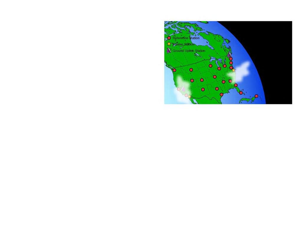
8 WAAS Architecture 38 Reference Stations 3 Master Stations 4 Ground Earth Stations 2 Geostationary Satellite Links 2 Operational Control Centers Wide Area Augmentation System (WAAS) Program Status Courtesy: Federal Aviation Administration 8


9 Geostationary Satellites (GEO) PanAmSat 133 W Telesat 107 W Provides Dual Coverage Over United States Wide Area Augmentation System (WAAS) Program Status Courtesy: Federal Aviation Administration 9
10 WAAS LPV and LPV-200 Vertical Position Error Distributions July 2003 to June 2006 Courtesy: FAA Technical Center 3 years 20 WRSs 1 Hz data 10
11 Integrity Approach 11!Aviation integrity operates on a guilty until proven innocent principle!error bound is the maximum possible value given the measurements!this is unlike conventional systems that describe the most likely errors!protection level is a % bound on worst reasonable conditions!very different from 95% achieved accuracy
12 Error Sources 12!Satellite errors!ephemeris!clock!signal!propagation errors!ionosphere!troposphere!local Errors!Multipath!Receiver Noise

13 GPS Performance (Usually) On a good day, the red circle encloses 95% of the GPS position fixes. 13

14 Major GPS Faults About Twice a Year Example: Ephemeris Failure on April 10, 2007 On a bad day, the GPS errors can be much worse. WAAS & GBAS eliminate these large errors. 14


15 Failure of Thin Shell Model 15 Quiet Day Disturbed Day

16 Undersampled Condition Courtesy: Seebany Datta-Barua 16
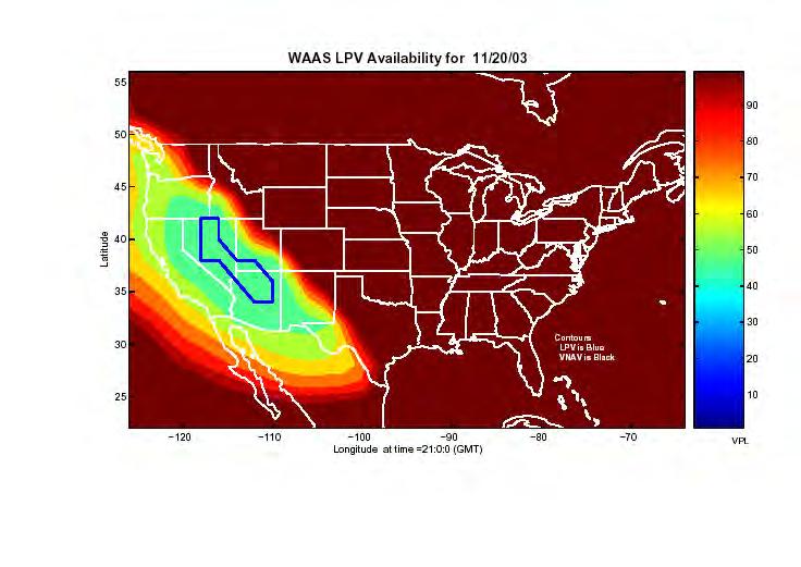
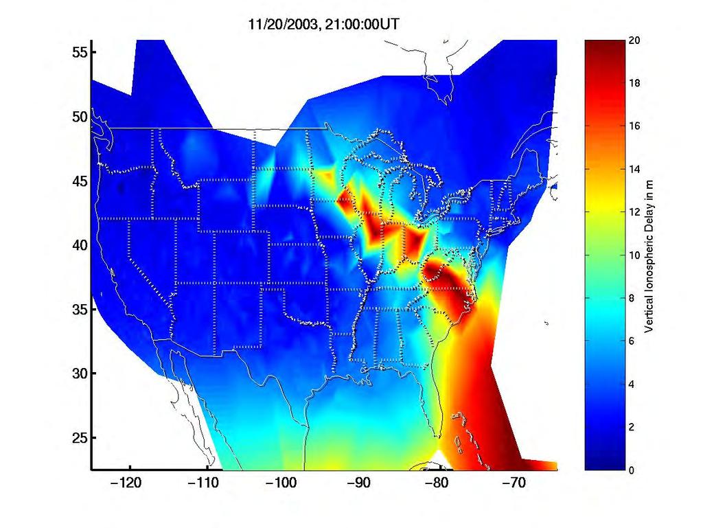
17 11/20/ :00:00 GMT 17
 Program Status Courtesy: Federal Aviation Administration")
18 Localizer Performance Vertical (LPV) Coverage Wide Area Augmentation System (WAAS) Program Status Courtesy: Federal Aviation Administration 18
")
19 WAAS RNP 0.3 Current Coverage Wide Area Augmentation System (WAAS) Program Status Courtesy: Federal Aviation Administration 19


20 Navigational Aids!Instrument Landing System (ILS)!Glideslope antenna for vertical!localizer for horizontal 20

21 ILS Installations: Each Runway End Requires At Least Two Transmitters 1318 ILS s nationwide 21
22 Airports with WAAS LPV No GPS Equipment Required at Airport 50 Pieces of WAAS Equipment Serve the Continent As of November, WAAS-based LPV s ~1000 for non ILS runways 22
23 Localizer Approaches at Moffett Field Courtesy: Sharon Houck 23
 Same decision ht. as Cat I GBAS for Cat.")
24 Utility of Protected Accuracy from WAAS Localizer performance with vertical guidance (LPV) Safer than lateral nav. (non-precision approach) Same decision ht. as Cat I GBAS for Cat. II & III WAAS (& GBAS) tunnels: Do not flare like ILS Do not have beam bends Are programmable Are adaptable 24

25 Current WAAS Performance 25

26 Future L1/L5 Performance 26
27 Potential of L1/L5 GPS/Galileo Performance 27
28 Conclusions 28!WAAS is used to provide aircraft navigation from enroute through vertically guided approach!integrity was and is the key challenge!important to understand what can go wrong and how to protect users!careful analysis of feasible threats!new civil frequencies and additional constellations may further improve performance
The Wide Area Augmentation System
 The Wide Area Augmentation System Stanford University http://waas.stanford.edu What is Augmentation? 2 Add to GNSS to Enhance Service Improve integrity via real time monitoring Improve availability and
Aviation Benefits of GNSS Augmentation
 Aviation Benefits of GNSS Augmentation Workshop on the Applications of GNSS Chisinau, Moldova 17-21 May 2010 Jeffrey Auerbach Advisor on GNSS Affairs Office of Space and Advanced Technology U.S. Department
Wide Area Augmentation System (WAAS)
") Wide Area Augmentation System (WAAS) Ionospheric Effects Symposium By: Jason Burns Technology Evolution Lead Date: Agenda WAAS Overview Ionospheric Effects on WAAS Future Plans User Segment Update 2 WAAS
Wide Area Augmentation System (WAAS) Ionospheric Effects Symposium By: Jason Burns Technology Evolution Lead Date: Agenda WAAS Overview Ionospheric Effects on WAAS Future Plans User Segment Update 2 WAAS
SBAS solution GCC, Yemen and Iraq System baseline and performance
 SBAS solution GCC, Yemen and Iraq System baseline and performance ACAC Workshop Rabat 7 & 8 November 2017 1 2017 Thales Alenia Space PROPRIETARY C O M MINFORMATION E R C I A L I N THALES C O ALENIA N F
What s up with WAAS?
 I N D U S T RY What s up with WAAS? There s a bright new star in the GPS constellation and pretty soon every bright pilot is going to want to use it. B Y D A L E S M I T H You probably didn t notice it
FAA GNSS Programs & GPS Evolutionary Architecture Study (GEAS) Status
 Status") FAA GNSS Programs & GPS Evolutionary Architecture Study (GEAS) Status Presented to: By: Date: Leo Eldredge, FAA Agenda Wide Area Augmentation System (WAAS) Status Local Area Augmentation System (LAAS)
FAA GNSS Programs & GPS Evolutionary Architecture Study (GEAS) Status Presented to: By: Date: Leo Eldredge, FAA Agenda Wide Area Augmentation System (WAAS) Status Local Area Augmentation System (LAAS)
Satellite-Based Augmentation System (SBAS) Integrity Services
 Integrity Services") Satellite-Based Augmentation System (SBAS) Integrity Services Presented To: Munich, Germany Date: March 8, 2010 By: Leo Eldredge, Manager GNSS Group, FAA FAA Satellite Navigation Program 2 Wide Area Augmentation
Satellite-Based Augmentation System (SBAS) Integrity Services Presented To: Munich, Germany Date: March 8, 2010 By: Leo Eldredge, Manager GNSS Group, FAA FAA Satellite Navigation Program 2 Wide Area Augmentation
SATELLITE BASED AUGMENTATION SYSTEM (SBAS) FOR AUSTRALIA
 FOR AUSTRALIA") SATELLITE BASED AUGMENTATION SYSTEM (SBAS) FOR AUSTRALIA AN AIN POSITION PAPER SUBMITTED TO VARIOUS GOVERNMENT DEPARTMENTS BY MR KYM OSLEY AM, CSC, EXEC SECRETARY AIN What are GNSS Augmentation Systems?
SATELLITE BASED AUGMENTATION SYSTEM (SBAS) FOR AUSTRALIA AN AIN POSITION PAPER SUBMITTED TO VARIOUS GOVERNMENT DEPARTMENTS BY MR KYM OSLEY AM, CSC, EXEC SECRETARY AIN What are GNSS Augmentation Systems?
Satellite Navigation Science and Technology for Africa. 23 March - 9 April, Air Navigation Applications (SBAS, GBAS, RAIM)
") 2025-25 Satellite Navigation Science and Technology for Africa 23 March - 9 April, 2009 Air Navigation Applications (SBAS, GBAS, RAIM) Walter Todd Stanford University Department of Applied Physics CA 94305-4090
2025-25 Satellite Navigation Science and Technology for Africa 23 March - 9 April, 2009 Air Navigation Applications (SBAS, GBAS, RAIM) Walter Todd Stanford University Department of Applied Physics CA 94305-4090
Integrity of Satellite Navigation in the Arctic
 Integrity of Satellite Navigation in the Arctic TODD WALTER & TYLER REID STANFORD UNIVERSITY APRIL 2018 Satellite Based Augmentation Systems (SBAS) in 2018 2 SBAS Networks in 2021? 3 What is Meant by Integrity?
IMPLEMENTATION OF GNSS BASED SERVICES
 International Civil Aviation Organization IMPLEMENTATION OF GNSS BASED SERVICES Julio Siu Communications, Navigation and Surveillance Regional Officer ICAO NACC Regional Office ICAO Workshop on PBN Airspace
GPS/WAAS Program Update
 GPS/WAAS Program Update UN/Argentina Workshop on the Applications of GNSS 19-23 March 2018 Cordoba, Argentina GNSS: A Global Navigation Satellite System of Systems Global Constellations GPS (24+3) GLONASS
Modernizing WAAS. Todd Walter and Per Enge, Stanford University, Patrick Reddan Zeta Associates Inc.
 Modernizing WAAS Todd Walter and Per Enge, Stanford University, Patrick Reddan Zeta Associates Inc. ABSTRACT The Wide Area Augmentation System (WAAS) became operational on July 10, 003. Currently this
GNSS for Landing Systems and Carrier Smoothing Techniques Christoph Günther, Patrick Henkel
 GNSS for Landing Systems and Carrier Smoothing Techniques Christoph Günther, Patrick Henkel Institute of Communications and Navigation Page 1 Instrument Landing System workhorse for all CAT-I III approach
GA and NextGen How technologies like WAAS and ADS-B will change your flying! Presented By Claire Kultgen
 GA and NextGen How technologies like WAAS and ADS-B will change your flying! Presented By Claire Kultgen Overview 1. TIS 2. ADS-B FIS-B TIS-B ADS-R 3. WAAS 4. T-Routes and GPS MEAs Questions Chat Pilot
Global Navigation Satellite System (GNSS) GPS Serves Over 400 Million Users Today. GPS is used throughout our society
 GPS Serves Over 400 Million Users Today. GPS is used throughout our society") Global avigation Satellite System (GSS) For freshmen at CKU AA December 10th, 2009 by Shau-Shiun Jan ICA & IAA, CKU Global avigation Satellite System (GSS) GSS (Global Positioning System, GPS) Basics Today
Global avigation Satellite System (GSS) For freshmen at CKU AA December 10th, 2009 by Shau-Shiun Jan ICA & IAA, CKU Global avigation Satellite System (GSS) GSS (Global Positioning System, GPS) Basics Today
GNSS Spectrum Issues and New GPS L5
 Federal Aviation Administration Washington, D.C. GNSS Spectrum Issues and New GPS L5 International Civil Aviation Organization Regional Coordination Meeting Lima, Peru March 27 28, 2001 Basic GPS System!Space
Near Term Improvements to WAAS Availability
 Near Term Improvements to WAAS Availability Juan Blanch, Todd Walter, R. Eric Phelts, Per Enge Stanford University ABSTRACT Since 2003, when it was first declared operational, the Wide Area Augmentation
Ground Based Augmentation Systems (GBAS) Introduction
 Introduction") Ground Based Augmentation Systems (GBAS) Introduction Technical and Operational Overview Andreas Lipp GBAS Implementation Workshop, ICAO EUR/NAT Paris, 18 March 2010 The European Organisation for the Safety
Ground Based Augmentation Systems (GBAS) Introduction Technical and Operational Overview Andreas Lipp GBAS Implementation Workshop, ICAO EUR/NAT Paris, 18 March 2010 The European Organisation for the Safety
Modern ARINC 743B DO-229D and DO-253C GLSSU Solutions For Retrofit
 Commercial Aviation Modern ARINC 743B DO-229D and DO-253C GLSSU Solutions For Retrofit Presented to AEEC March 2010 The Classic Retrofit Challenge Financial: Operating budget year financing ROI payback:
GBAS FOR ATCO. June 2017
 GBAS FOR ATCO June 2017 Disclaimer This presentation is for information purposes only. It should not be relied on as the sole source of information, and should always be used in the context of other authoritative
GNSS: CNS Dependencies
 GNSS: CNS Dependencies Lendina Smaja DATM/RDS/NAV 10 March 2015 Agenda The Future Technical Environment GNSS GNSS Supporting CNS Loss of Signal Impact GNSS: CNS Dependencies 2 Original FANS CNS/ATM Concept
Galileo & EGNOS Programmes Status
 Galileo & EGNOS Programmes Status Ugo Celestino, European Commission EURO-MEDITERRANEAN TRANSPORT FORUM GNSS WORKING GROUP 16 th October 2012 17 October, 2012 The European GNSS Programmes 2 Table of contents
GEO 428: DEMs from GPS, Imagery, & Lidar Tuesday, September 11
 GEO 428: DEMs from GPS, Imagery, & Lidar Tuesday, September 11 Global Positioning Systems GPS is a technology that provides Location coordinates Elevation For any location with a decent view of the sky
ICAO policy on GNSS, GNSS SARPs and global GNSS developments. Jim Nagle Chief, Communication, Navigation and Surveillance Section ICAO
 ICAO policy on GNSS, GNSS SARPs and global GNSS developments Jim Nagle Chief, Communication, Navigation and Surveillance Section ICAO Presentation overview Introduction GNSS developments in ICAO ICAO policy
Aircraft Landing Systems Based on GPS & Galileo
 Aircraft Landing Systems Based on GPS & Galileo for the Czech Technical University by Per Enge Thursday 4 August, 2005 Future Aircraft Landing Systems: Outline 1. Today: Global Positioning System (GPS)
AIRCRAFT LANDING USING A MODERNIZED GLOBAL POSITIONING SYSTEM AND THE WIDE AREA AUGMENTATION SYSTEM
 AIRCRAFT LANDING USING A MODERNIZED GLOBAL POSITIONING SYSTEM AND THE WIDE AREA AUGMENTATION SYSTEM A DISSERTATION SUBMITTED TO THE DEPARTMENT OF AERONAUTICS AND ASTRONAUTICS AND THE COMMITTEE ON GRADUATE
Broadcasting Data from an SBAS Reference Network over Low Rate Broadcast Channels
 Broadcasting Data from an SBAS Reference Network over Low Rate Broadcast Channels Sherman C. Lo, Per Enge Department of Aeronautics and Astronautics, Stanford University BIOGRAPHY Sherman Lo is a Ph.D.
Introduc)on to GNSS Integrity & Space- Based Augmenta)on Systems
on to GNSS Integrity & Space- Based Augmenta)on Systems") Introduc)on to GNSS Integrity & Space- Based Augmenta)on Systems for GNSS Technologies Advances in a Mul)- constella)on Framework Sogei S.p.A., Roma by Per Enge April 22 & 23, 2013 History of GPS Service
Introduc)on to GNSS Integrity & Space- Based Augmenta)on Systems for GNSS Technologies Advances in a Mul)- constella)on Framework Sogei S.p.A., Roma by Per Enge April 22 & 23, 2013 History of GPS Service
[EN A 78] Development of a CAT III GBAS (GAST D) ground subsystem prototype and its performance evaluation with a long term data set
![[EN A 78] Development of a CAT III GBAS (GAST D) ground subsystem prototype and its performance evaluation with a long term data set](/thumbs/96/128212036.jpg "[EN A 78] Development of a CAT III GBAS (GAST D) ground subsystem prototype and its performance evaluation with a long term data set") [EN A 78] Development of a CAT III GBAS (GAST D) ground subsystem prototype and its performance evaluation with a long term data set (EIWAC 2017) + T. Yoshihara*, S. Saito*, A. Kezuka*, K. Hoshinoo*, S.
[EN A 78] Development of a CAT III GBAS (GAST D) ground subsystem prototype and its performance evaluation with a long term data set (EIWAC 2017) + T. Yoshihara*, S. Saito*, A. Kezuka*, K. Hoshinoo*, S.
GAGAN implementation and certification Programme. Presented by India
 GAGAN implementation and certification Programme Presented by India GPS Aided Geo Augmented Navigation International Civil Aviation Organization (ICAO) Member States Endorsed Global Satellite Navigation
On Location at Stanford University
 Thank you for inviting me to Calgary On Location at Stanford University by Per Enge (with the help of many) May 29, 2009 With Gratitude to the Federal Aviation Administration from Misra and Enge, 2006
Development of a GAST-D ground subsystem prototype and its performance evaluation with a long term-data set
 Development of a GAST-D ground subsystem prototype and its performance evaluation with a long term-data set T. Yoshihara, S. Saito, A. Kezuka, K. Hoshinoo, S. Fukushima, and S. Saitoh Electronic Navigation
On Location at Stanford University
 Thank you for inviting me (back) to Southern California On Location at Stanford University by Per Enge (with the help of many) June 30, 2009 My thanks to the Federal Aviation Administration Outline Landing
Overview of GNSS Navigation Sources, Augmentation Systems, and Applications
 Overview of GNSS Navigation Sources, Augmentation Systems, and Applications The Ionosphere and its Effects on GNSS Systems 14 to 16 April 2008 Santiago, Chile Dr. S. Vincent Massimini Global Navigation
Special Committee SC-159 Navigation Equipment Using the Global Navigation Satellite System (GNSS) (Version 11)
 (Version 11)") RTCA Paper No. 094-18/PMC-1737 March 22, 2018 TERMS OF REFERENCE Special Committee SC-159 Navigation Equipment Using the Global Navigation Satellite System (GNSS) (Version 11) REQUESTOR: Organization Person
RTCA Paper No. 094-18/PMC-1737 March 22, 2018 TERMS OF REFERENCE Special Committee SC-159 Navigation Equipment Using the Global Navigation Satellite System (GNSS) (Version 11) REQUESTOR: Organization Person
Status of ARAIM. S. Wallner ICG 6, Tokyo, Japan 05/09/2011. ESA UNCLASSIFIED For Official Use
 Status of ARAIM S. Wallner ICG 6, Tokyo, Japan 05/09/2011 ARAIM Concept Objectives Classical GPS RAIM for NPA used since years Evolving GNSS environment Multi-GNSS GPS/Galileo/Glonass/Compass/QZSS Dual-frequency
On Location at Stanford University
 Thank you for inviting me (back) to Deutsches Zentrum für Luft- und Raumfahrt On Location at Stanford University by Per Enge (with the help of many) July 27, 2009 My thanks to the Federal Aviation Administration
AEEC 2013 Presentation to the Airlines and the Aviation Industry
 AEEC 2013 Presentation to the Airlines and the Aviation Industry Multi-Frequency/Multi-Constellation (MFMC) GNSS Receivers Value for Aviation and Airlines John Studenny CMC GPS Product Manager Alain Beaulieu
GAGAN Initiatives Jan 18, 2018
 GAGAN Initiatives Jan 18, 2018 Topics covered 1. Brief profile of GAGAN 2. Features / Accuracy of GAGAN System 3. GAGAN Architecture 4. GAGAN services and Coverage 5. GAGAN utilization in aviation sector
Special Committee SC-159 Navigation Equipment Using the Global Navigation Satellite System (GNSS) (Version 13)
 (Version 13)") RTCA Paper No. 307-18/PMC-1839 December 13, 2018 TERMS OF REFERENCE Special Committee SC-159 Navigation Equipment Using the Global Navigation Satellite System (GNSS) (Version 13) REQUESTOR: Organization
RTCA Paper No. 307-18/PMC-1839 December 13, 2018 TERMS OF REFERENCE Special Committee SC-159 Navigation Equipment Using the Global Navigation Satellite System (GNSS) (Version 13) REQUESTOR: Organization
Development of Satellite Navigation for Aviation (FAA Award No. 95-G-005) Technical Description of Project and Results Stanford University June 2009
 Technical Description of Project and Results Stanford University June 2009") 1.0 Introduction Development of Satellite Navigation for Aviation (FAA Award No. 95-G-005) Technical Description of Project and Results Stanford University June 2009 This report describes the key elements
1.0 Introduction Development of Satellite Navigation for Aviation (FAA Award No. 95-G-005) Technical Description of Project and Results Stanford University June 2009 This report describes the key elements
RAIM Availability prediction
 RAIM Availability prediction Main content 一 Background & research purposes 二 Related research in China and abroad 三 Theory and arithmetic 四 RAIM systems development 五 The vision of the future 1 Background
Vertical Guidance Performance Analysis of the L1-L5 Dual-Frequency GPS/WAAS User Avionics Sensor
 Sensors 010, 10, 9-65; doi:10.3390/s1009 OPEN ACCESS sensors ISSN 144-80 www.mdpi.com/journal/sensors Article Vertical Guidance Performance Analysis of the L1-L5 Dual-Frequency GPS/WAAS User Avionics Sensor
Radio Navigation Aids Flight Test Seminar
 Radio Navigation Aids Flight Test Seminar FLIGHT INSPECTION IN THE NEW MILLENNIUM Curt Keedy FAA Flight Inspection Policy and Standards Change, Challenge, and Opportunity CHANGES Global Positioning system
INTEGRITY AND CONTINUITY ANALYSIS FROM GPS JULY TO SEPTEMBER 2016 QUARTERLY REPORT
 INTEGRITY AND CONTINUITY ANALYSIS FROM GPS JULY TO SEPTEMBER 2016 QUARTERLY REPORT Name Responsibility Date Signature Prepared by M Pattinson (NSL) 07/10/16 Checked by L Banfield (NSL) 07/10/16 Authorised
> ATM Seminar 2015 > Dauterrmann/Geister 376 >
 DLR.de Chart 1 Combining Advanced-RNP with SBAS Guided Precision Terminal Area Paths and Final Approach Guidance Exploiting All Benefits from Performance Based Navigation Thomas Dautermann and Robert Geister
Alternate Position, Navigation & Time APNT for Civil Aviation
 Alternate Position, Navigation & Time APNT for Civil Aviation For Working Group B of the International GNSS Committee Shanghai, May 2011 by Per Enge & Leo Eldredge Work supported by the Federal Aviation
Japan-US Aviation Environmental Workshop Fukutake Hall University of Tokyo 29 November 2017
 Japan-US Aviation Environmental Workshop Fukutake Hall University of Tokyo 29 November 2017 Keiichi Tamura All Nippon Airways B787 Technical Pilot, Dr. Eng. 2 Fundamentals of PBN (RNAV / RNP) Fundamentals
Recent Progress on Aviation Integrity
 Recent Progress on Aviation Integrity for the Institute of Navigation on September 17, 2008 by Per Enge, Stanford University Acknowledgement: This work was sponsored by the FAA Satellite Navigation Office
Ionospheric Corrections for GNSS
 Ionospheric Corrections for GNSS The Atmosphere and its Effect on GNSS Systems 14 to 16 April 2008 Santiago, Chile Ing. Roland Lejeune Overview Ionospheric delay corrections Core constellations GPS GALILEO
January 16, 2011 Scott Burgett, Bronson Hokuf Garmin International, Olathe, Kansas
 Experimental Evidence of Wide Area GPS Jamming That Will Result from LightSquared s Proposal to Convert Portions of L Band 1 to High Power Terrestrial Broadband Executive Summary January 16, 2011 Scott
Een GPS naderingshulpmiddel voor de kleine luchtvaart
 Technische ontwikkelingen: Een GPS naderingshulpmiddel voor de kleine luchtvaart Christian Tiberius Faculteit Luchtvaart- en Ruimtevaarttechniek TU Delft WORKSHOP Is er nog Lucht(ruim) voor de Kleine Luchtvaart
Horizontal Advanced RAIM: Operational Benefits and Future Challenges
 Horizontal Advanced RAIM: Operational Benefits and Future Challenges International Technical Symposium on Navigation and Timing 2015 Session Air Navigation November 2015 Toulouse/France 1 ICAO ABAS augmentation
CONSIDERATIONS FOR GNSS MEASUREMENTS
 CONSIDERATIONS FOR GNSS MEASUREMENTS Cornel PĂUNESCU 1, Cristian VASILE 2, Cosmin CIUCULESCU 3 1 PhD University of Bucharest, e-mail: cornelpaun@gmail.com 2 Lecturer PhD University of Craiova, cristi_vasile_4you@yahoo.com
GNSS-based Flight Inspection Systems
 GNSS-based Flight Inspection Systems Euiho Kim, Todd Walter, and J. David Powell Department of Aeronautics and Astronautics Stanford University Stanford, CA 94305, USA Abstract This paper presents novel
ELEVENTH AIR NAVIGATION CONFERENCE. Montreal, 22 September to 3 October 2003 TOOLS AND FUNCTIONS FOR GNSS RAIM/FDE AVAILABILITY DETERMINATION
 19/9/03 ELEVENTH AIR NAVIGATION CONFERENCE Montreal, 22 September to 3 October 2003 Agenda Item 6 : Aeronautical navigation issues TOOLS AND FUNCTIONS FOR GNSS RAIM/FDE AVAILABILITY DETERMINATION (Presented
Prototyping Advanced RAIM for Vertical Guidance
 Prototyping Advanced RAIM for Vertical Guidance Juan Blanch, Myung Jun Choi, Todd Walter, Per Enge. Stanford University Kazushi Suzuki. NEC Corporation Abstract In the next decade, the GNSS environment
The Global Positioning System
 The Global Positioning System 5-1 US GPS Facts of Note DoD navigation system First launch on 22 Feb 1978, fully operational in 1994 ~$15 billion (?) invested to date 24 (+/-) Earth-orbiting satellites
12.S56 GPS: Where Are You? Fall 2008
 MIT OpenCourseWare http://ocw.mit.edu 12.S56 GPS: Where Are You? Fall 2008 For information about citing these materials or our Terms of Use, visit: http://ocw.mit.edu/terms. 12S56 GPS Basics of Handheld
Figure 2: Maximum Ionosphere-Induced Vertical Errors at Memphis
 277 Figure 2: Maximum Ionosphere-Induced Vertical Errors at Memphis 278 Figure 3: VPL Inflation Required to Remove Unsafe Geometries 279 280 Figure 4: Nominal IPP Scenario All Surrounding IGPs are Good
GPS Milestones, cont. GPS Milestones. The Global Positioning Sytem, Part 1 10/10/2017. M. Helper, GEO 327G/386G, UT Austin 1. US GPS Facts of Note
 The Global Positioning System US GPS Facts of Note DoD navigation system First launch on 22 Feb 1978, fully operational in 1994 ~$15 billion (?) invested to date 24 (+/-) Earth-orbiting satellites (SVs)
SENSORS SESSION. Operational GNSS Integrity. By Arne Rinnan, Nina Gundersen, Marit E. Sigmond, Jan K. Nilsen
 Author s Name Name of the Paper Session DYNAMIC POSITIONING CONFERENCE 11-12 October, 2011 SENSORS SESSION By Arne Rinnan, Nina Gundersen, Marit E. Sigmond, Jan K. Nilsen Kongsberg Seatex AS Trondheim,
Fault Detection and Elimination for Galileo-GPS Vertical Guidance
 Fault Detection and Elimination for Galileo-GPS Vertical Guidance Alexandru Ene, Juan Blanch, J. David Powell, Stanford University BIOGRAPHY Alex Ene is a Ph.D. candidate in Aeronautical and Astronautical
Distributed integrity monitoring of differential GPS corrections
 Distributed integrity monitoring of differential GPS corrections by Martin Pettersson Supervised by Fredrik Gustafsson Niclas Bergman Department of Automatic Control University of Linköpings Made for Luftfartsverket
Modern Navigation. Thomas Herring
 12.215 Modern Navigation Thomas Herring Summary of Last class Satellite Orbits Treat the basic description and dynamics of satellite orbits Major perturbations on GPS satellite orbits Sources of orbit
HORIZONTAL ARAIM AVAILABILITY FOR CIVIL AVIATION OPERATIONS. ARAIM Outreach event
 HORIZONTAL ARAIM AVAILABILITY FOR CIVIL AVIATION OPERATIONS ARAIM Outreach event Moses1978 copyright April 7, 2017 H-ARAIM availability for civil aviation operations 07/04/2017 1 INTRODUCTION Space Segment
APPENDIX C VISUAL AND NAVIGATIONAL AIDS
 VISUAL AND NAVIGATIONAL AIDS APPENDIX C VISUAL AND NAVIGATIONAL AIDS An integral part of the airport system is the visual and navigational aids provided to assist pilots in navigating both on the airfield
CONCEPT OF OPERATIONS (CONOPS) FOR DUAL-FREQUENCY MULTI-CONSTELLATION (DFMC) GLOBAL NAVIGATION SATELLITE SYSTEM (GNSS)
 FOR DUAL-FREQUENCY MULTI-CONSTELLATION (DFMC) GLOBAL NAVIGATION SATELLITE SYSTEM (GNSS)") CONCEPT OF OPERATIONS (CONOPS) FOR DUAL-FREQUENCY MULTI-CONSTELLATION (DFMC) GLOBAL NAVIGATION SATELLITE SYSTEM (GNSS) Prepared by the ICAO Navigation Systems Panel CONOPS V6.4 Page 1 of 49 27 April 2018
CONCEPT OF OPERATIONS (CONOPS) FOR DUAL-FREQUENCY MULTI-CONSTELLATION (DFMC) GLOBAL NAVIGATION SATELLITE SYSTEM (GNSS) Prepared by the ICAO Navigation Systems Panel CONOPS V6.4 Page 1 of 49 27 April 2018
GPS Errors. Figure 1. Four satellites are required to determine a GPS position.
 Expl ai ni nggps:thegl obalposi t i oni ngsyst em since a minimum of four satellites is required to calculate a position (Fig 1). However, many newer GPS receivers are equipped to receive up to 12 satellite
The Use of Raw GPS for Vertical Navigation
 The Use of Raw GPS for Vertical Navigation J.D. Andrew Graham, P.Eng NAV CANADA Biography Andrew Graham is a project engineer with NAV CANADA s Satellite Navigation Program Office in Ottawa, Canada, where
RESULTS OF THE REGIONAL SBAS TEST BED TYPE WAAS PROYECT RLA/00/009. Onofrio Smarrelli ICAO SAM CNS Lima Regional Office
 WORKSHOP / SEMINAR FOR THE IMPLEMENTATION OF NAVIGATION INFRASTRUCTURE TO SUPPORT PBN AND GNSS PRECISION APPROACH OPERATIONS IN THE NAM CAR SAM REGION (Lima, Peru 15 to 17 August 2016 ) RESULTS OF THE
Nigerian Communications Satellite Ltd. (NIGCOMSAT)
") OVERVIEW OF NIGERIAN SATELLITE AUGMENTATION SYSTEM COMMENCING WITH PILOT DEMONSTRATION TO VALIDATE NATIONAL WORK PLAN presented by Dr. Lawal Lasisi Salami, NIGERIAN COMMUNICATIONS SATELLITE LTD UNDER FEDERAL
OVERVIEW OF NIGERIAN SATELLITE AUGMENTATION SYSTEM COMMENCING WITH PILOT DEMONSTRATION TO VALIDATE NATIONAL WORK PLAN presented by Dr. Lawal Lasisi Salami, NIGERIAN COMMUNICATIONS SATELLITE LTD UNDER FEDERAL
ENSTROM 480B OPERATOR S MANUAL AND FAA APPROVED ROTORCRAFT FLIGHT MANUAL SUPPLEMENT GARMIN GTN 650 NAVIGATION SYSTEM
 ENSTROM 480B OPERATOR S MANUAL AND FAA APPROVED ROTORCRAFT FLIGHT MANUAL SUPPLEMENT GARMIN GTN 650 NAVIGATION SYSTEM * * * * * REPORT NO. 28-AC-064 HELICOPTER SERIAL NO. HELICOPTER REGISTRATION NO. * *
GNSS Solutions: Do GNSS augmentation systems certified for aviation use,
 GNSS Solutions: WAAS Functions and Differential Biases GNSS Solutions is a regular column featuring questions and answers about technical aspects of GNSS. Readers are invited to send their questions to
NR402 GIS Applications in Natural Resources
 NR402 GIS Applications in Natural Resources Lesson 5 GPS/GIS integration Global Positioning System (GPS)..a global navigation system that everyone can use What is GPS? How does it work? How accurate is
Methodology and Case Studies of Signal-in-Space Error Calculation Top-down Meets Bottom-up
 Methodology and Case Studies of Signal-in-Space Error Calculation Top-down Meets Bottom-up Grace Xingxin Gao*, Haochen Tang*, Juan Blanch*, Jiyun Lee+, Todd Walter* and Per Enge* * Stanford University,
Scientific Journal of Silesian University of Technology. Series Transport Zeszyty Naukowe Politechniki Śląskiej. Seria Transport
 Scientific Journal of Silesian University of Technology. Series Transport Zeszyty Naukowe Politechniki Śląskiej. Seria Transport Volume 93 2016 p-issn: 0209-3324 e-issn: 2450-1549 DOI: https://doi.org/10.20858/sjsutst.2016.93.13
PORTABLE GNSS MONITORING STATION (PGMS)
") SPACE PORTABLE GNSS MONITORING STATION (PGMS) Satellite communications, earth observation, navigation and positioning and control stations indracompany.com PORTABLE GNSS MONITORING STATION (PGMS) PORTABLE
SPACE PORTABLE GNSS MONITORING STATION (PGMS) Satellite communications, earth observation, navigation and positioning and control stations indracompany.com PORTABLE GNSS MONITORING STATION (PGMS) PORTABLE
PBN fleet equipage according to FPL content. Michel ROELANDT
 PBN fleet equipage according to FPL content Michel ROELANDT EUROCONTROL RAiSG/PBN TF Meeting March 2014 Introduction 15 Nov 2012: standard ICAO format for airline flight plans changed. New fields have
ASSEMBLY 37TH SESSION
 International Civil Aviation Organization WORKING PAPER A37-WP/195 1 22/9/10 (Information paper) ASSEMBLY 37TH SESSION TECHNICAL COMMISSION Agenda Item 35: The Global Air Traffic Management (ATM) System
ARAIM Fault Detection and Exclusion
 ARAIM Fault Detection and Exclusion Boris Pervan Illinois Institute of Technology Chicago, IL November 16, 2017 1 RAIM ARAIM Receiver Autonomous Integrity Monitoring (RAIM) uses redundant GNSS measurements
Demonstrations of Multi-Constellation Advanced RAIM for Vertical Guidance using GPS and GLONASS Signals
 Demonstrations of Multi-Constellation Advanced RAIM for Vertical Guidance using GPS and GLONASS Signals Myungjun Choi, Juan Blanch, Stanford University Dennis Akos, University of Colorado Boulder Liang
Advisory Circular. U.S. Department of Transportation Federal Aviation Administration
 U.S. Department of Transportation Federal Aviation Administration Advisory Circular Subject: Airworthiness Approval of Automatic Date: 11/07/12 AC No: 20-165A Dependent Surveillance - Broadcast (ADS-B)
CHIPS Technology Roadmap February 2012 VERSION 1.0
 CHIPS Technology Roadmap February 2012 VERSION 1.0 circulation 150 copyright skyguide - swiss air navigation services ltd design confident gmbh CHIPS Technology Roadmap February 2012 Version 1.0 CH-wide
AE4-393: Avionics Exam Solutions
 AE4-393: Avionics Exam Solutions 2008-01-30 1. AVIONICS GENERAL a) WAAS: Wide Area Augmentation System: an air navigation aid developed by the Federal Aviation Administration to augment the Global Positioning
Introduction to Advanced RAIM. Juan Blanch, Stanford University July 26, 2016
 Introduction to Advanced RAIM Juan Blanch, Stanford University July 26, 2016 Satellite-based Augmentation Systems Credit: Todd Walter Receiver Autonomous Integrity Monitoring (556 m Horizontal Error Bound)
Analysis of a Three-Frequency GPS/WAAS Receiver to Land an Airplane
 Analysis of a Three-Frequency GPS/WAAS Receiver to Land an Airplane Shau-Shiun Jan Department of Aeronautics and Astronautics Stanford University, California 94305 BIOGRAPHY Shau-Shiun Jan is a Ph.D. candidate
Cockpit Visualization of Curved Approaches based on GBAS
 www.dlr.de Chart 1 Cockpit Visualization of Curved Approaches based on GBAS R. Geister, T. Dautermann, V. Mollwitz, C. Hanses, H. Becker German Aerospace Center e.v., Institute of Flight Guidance www.dlr.de
ENSTROM 480/480B OPERATOR S MANUAL AND FAA APPROVED ROTORCRAFT FLIGHT MANUAL SUPPLEMENT GARMIN GNS 430W/530W NAVIGATION SYSTEM
 ENSTROM 480/480B OPERATOR S MANUAL AND FAA APPROVED ROTORCRAFT FLIGHT MANUAL SUPPLEMENT GARMIN GNS 430W/530W NAVIGATION SYSTEM * * * * * REPORT NO. 28-AC-055 HELICOPTER SERIAL NO. HELICOPTER REGISTRATION
Satellite Selection for Multi-Constellation SBAS
 Satellite Selection for Multi-Constellation SBAS Todd Walter, Juan Blanch Stanford University Victoria Kropp University FAF Munich ABSTRACT The incorporation of multiple constellations into satellite based
Lecture-1 CHAPTER 2 INTRODUCTION TO GPS
 Lecture-1 CHAPTER 2 INTRODUCTION TO GPS 2.1 History of GPS GPS is a global navigation satellite system (GNSS). It is the commonly used acronym of NAVSTAR (NAVigation System with Time And Ranging) GPS (Global
GAGAN-Extension to the Gulf Region. Joint ACAC/ICAO MID Workshop on GNSS 7 th & 8 th November 2017
 GAGAN-Extension to the Gulf Region Joint ACAC/ICAO MID Workshop on GNSS 7 th & 8 th November 2017 P.N.S. KUSHWAHA EXECUTIVE DIRECTOR (CNS P) Airports Authority of India New Delhi Topics covered : 1. GAGAN
INTERNATIONAL CIVIL AVIATION ORGANIZATION
 INTERNATIONAL CIVIL AVIATION ORGANIZATION AFI PLANNING AND IMPLEMENTATION REGIONAL GROUP EIGHTEENTH MEETING (APIRG/18) Kampala, Uganda (27 30 March 2012) Agenda Item 3: Performance Framework for Regional
Enabling the LAAS Differentially Corrected Positioning Service (DCPS): Design and Requirements Alternatives
: Design and Requirements Alternatives") Enabling the LAAS Differentially Corrected Positioning Service (DCPS): Design and Requirements Alternatives Young Shin Park, Sam Pullen, and Per Enge, Stanford University BIOGRAPHIES Young Shin Park is
Enabling the LAAS Differentially Corrected Positioning Service (DCPS): Design and Requirements Alternatives Young Shin Park, Sam Pullen, and Per Enge, Stanford University BIOGRAPHIES Young Shin Park is
Several ground-based augmentation system (GBAS) Galileo E1 and E5a Performance
 Galileo E1 and E5a Performance") » COVER STORY Galileo E1 and E5a Performance For Multi-Frequency, Multi-Constellation GBAS Analysis of new Galileo signals at an experimental ground-based augmentation system (GBAS) compares noise and
» COVER STORY Galileo E1 and E5a Performance For Multi-Frequency, Multi-Constellation GBAS Analysis of new Galileo signals at an experimental ground-based augmentation system (GBAS) compares noise and
Experiences in. Flight Inspecting GBAS
 Experiences in Flight Inspecting GBAS Thorsten Heinke Aerodata AG 1 Flight Inspection of GBAS Overview Basics Requirements Equipment Flight Inspection 2 Ground Based Augmentation System VDB Tx-Frequency
REPORT OF COMMITTEE B TO THE CONFERENCE ON AGENDA ITEM 6
 1/10/03 ELEVENTH AIR NAVIGATION CONFERENCE Montreal, 22 September to 3 October 2003 REPORT OF COMMITTEE B TO THE CONFERENCE ON AGENDA ITEM 6 The attached report has been approved by Committee B for submission
Final Project Report. Abstract. Document information
 Final Project Report Document information Project Title Multi-constellation GNSS Airborne Navigation Systems Project Number 09.27 Project Manager Thales Avionics Deliverable Name Final Project Report Deliverable
INTEGRITY AND CONTINUITY ANALYSIS FROM GPS JANUARY TO MARCH 2017 QUARTERLY REPORT
 INTEGRITY AND CONTINUITY ANALYSIS FROM GPS JANUARY TO MARCH 2017 QUARTERLY REPORT Name Responsibility Date Signature Prepared by M Pattinson (NSL) 11/04/17 Checked by L Banfield (NSL) 11/04/17 Authorised