RAIM Availability prediction
|
|
|
- Amie Mosley
- 6 years ago
- Views:
Transcription


1 RAIM Availability prediction

2 Main content 一 Background & research purposes 二 Related research in China and abroad 三 Theory and arithmetic 四 RAIM systems development 五 The vision of the future

3 1 Background & research purposes The basic for PBN procedure is the navigation system meet the requirement of accuracy, integrity, availability, continuity Integrity it that when the satellite positioning error exceeds the allowable limit, system has the ability to alarm timely. RNP operation based on satellite navigation system must ensure the integrity of the system. To deal with possible satellite navigation signal abnormalities.
4 Background & research purposes At present, there are 3 method to augment GPS system integrity : Aircraft Based Augmentation System ABAS Ground Based augmentation System GBAS Satellite Based augmentation System SBAS
5 Background & research purposes RAIM (Receiver Autonomous Integrity Monitoring ) is a algorithm setting in a GPS receiver, respond quickly to satellite failure and completely automatic, and without outside intervention. But the application of RAIM technology can not ensure 100% available : (1) RAIM requires the more than 5 better geometric satellite distribution, this has led some time RAIM is not available. (2) Short outage problem of GPS satellite will also make the RAIM coverage holes more serious RAIM Enroute Terminal NPA Fault detection % % % time 5min 10min 30min
6 Background & research purposes For civil aviation users, using RAIM availability prediction enhance the availability of GPS to avoid RAIM hole problem during a flight.
7 Background & research purposes The aim of RAIM Availability Forecast Algorithm is as far as possible to accurate simulate the airborne receiver RAIM calculation results. (1)The basic algorithm for constellation autonomous integrity is identical. (2)At the same time flight path, terrain data and performance of airborne receiver also needed.
8 2 Related system Some countries have established RAIM prediction system :FAA Australia German Eurocontrol AUGUR ATMB Above system does not take the terrain and receiver performance into considerations. Commercial system : Jeppesen IDS Naverus The relevant standards and documentation :AC20-138A AC90-96A TGL2Rev.1 TGL3Rev.1 TGL10 TSO-C129a TSO-C145b/146b ICAO PBN RTCA DO-208 RTCA DO-229D

9 3 The principle and algorithm 3.1 Satellite visibility calculation 3.2 RAIM algorithm 3.3 Impact Analysis of flight path 3.4 Impact Analysis of terrain masking 3.5 Impact Analysis of receiver performance
10 3.1 Constellation visibility calculation The broadcast ephemeris and almanac are used to compute the Satellite visibility in the future. broadcast ephemeris provide Satellite clock error, Kepler orbit parameters and Orbit perturbation correction. Broadcast ephemeris updated every 2hours. In a short period after updated, the satellite position can reach meter accuracy level. Using broadcast ephemeris to calculate satellite position, the accuracy decreases rapidly with the increase of relative reference time interval.
11 Almanac Almanac is the general form of broadcast ephemeris, include only the Kepler orbit and clock parameters correction parameters, provide low accuracy satellite position for the user. period of almanac validity is more than six mouth, Ephemeris those short-term effective perturbation correction is not much significance For longer Almanac Updated cycle, The use calculation of satellite position can only achieve kilometer level accuracy, but it could take a long time to maintain.
12 Almanac received or download Directly download from the GPS receiver to, data receiving cycle for 12minutes The latest almanac data is collected by USA Coast Guard navigation center, according to each GPS forecast cycle. By entering the web site, you can use transfer protocol (FTP) or hypertext transfer protocol (HTTP) for data acquisition GPS constellation state (NANU) data report GPS satellite momentary interruption of unavailable information, you can download from American Coast Guard navigation center too.
13 Almanac parameters
14 The calculation of satellite visibility Satellite elevation angle h can be calculated by using the receiver position and the satellite position All the satellites which elevation angle h h0 (generally 5 ) can be used by receiver at that time
15 3.2 RAIM Algorithm RAIM is a techniques checking the satellite measurements consistency by using overdetermined solutions. For fault detection(fd), at least 5 visible satellites are needed. If the satellite fault detected, the pilot in the cockpit can receive a warning, indicating that GPS is not available For fault detection and exclusion (FDE), at least 6 visible satellites are needed. This can be excluded from the fault satellite navigation solution, so that the operation can continue without interrupted.
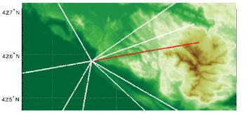
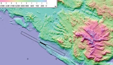
16 RAIM algorithm flow and module RAIM algorithm flow can be expressed as the form. The key module is fault detection algorithm and Geometry Screening algorithm.
17 RAIM Fault detection Algorithm snapshot method: Calculation based only on the current redundant observation data. The current mainstream systems usually use snapshot method, snapshot method include: Pseudo range comparison least square residuals Parity space ARP HPL etc. The above method is validated basically equivalent.

18 HPL Algorithm P FA is False alarm rate,the probability of there is no fault but told the pilots have a fault;p MD is Missed Detection rate, the probability of there is a fault but not decteted.
19 HPL Algorithm HPL=SLOPE max pbias, pbias=σ uere *sqrt(λ) λnon central parameterχ 2 of non central density function, σ uere is the standard deviation of satellite pseudo range measurement error
20 UERE
21 RAIM prediction result RAIM prediction is a simulation algorithm, unable to calculate SSE as the test statistics. Only need to judge whether HPL will be greater than HAL Once somewhere calculated HPL more than HAL, then the RAIM is not available. In fact, the calculation of HPL is related to the amount of visible satellites, UERE, constellation geometry, PFA and PMD values.


22 3.3 Affect of flight path and attitude RAIM prediction should consider the impact of flight attitude and flight path

23 3.4 Affect of terrain masking RNP approach based on GNSS in complex terrain, need to research the impact of terrain on the satellite visibility, to improve the traditional RAIM algorithm. RAIM availability prediction algorithm combined with digital terrain model (DEM), the DTM data could be directly imported to the prediction.
24 Terrain visibility algorithm
25 Impact of antenna and the receiver performance GPS antenna prformance(rtca DO-228) GPS receiver performance(rtca DO-229D)

 could be predicted After a long time")

26 RAIM prediction system RAIM availability prediction system has been developed, different airport, elevation angle, RNP (HAL) could be predicted After a long time comparison, the caculation are identical with the Eurocontrol website. a variety of ways for publishment.

27 Airport Positon Caculation comparison

28 Caculation comparison Revelent airport comparison


29 RAIM prediction service At present providing the service for Air China, China Southern Airlines, Shenzhen Airlines and other companies.


30 4 Application of RAIM prediction At present, the ways for sending RAIM prediction are website, FTP and mail
31 5 The vision of future In view of the development and application of Beidou, research on Beidou and multi constellation. research RAIM algorithm based on multi sensor.
32 THANK YOU!
INTEGRITY AND CONTINUITY ANALYSIS FROM GPS JULY TO SEPTEMBER 2016 QUARTERLY REPORT
 INTEGRITY AND CONTINUITY ANALYSIS FROM GPS JULY TO SEPTEMBER 2016 QUARTERLY REPORT Name Responsibility Date Signature Prepared by M Pattinson (NSL) 07/10/16 Checked by L Banfield (NSL) 07/10/16 Authorised
ELEVENTH AIR NAVIGATION CONFERENCE. Montreal, 22 September to 3 October 2003 TOOLS AND FUNCTIONS FOR GNSS RAIM/FDE AVAILABILITY DETERMINATION
 19/9/03 ELEVENTH AIR NAVIGATION CONFERENCE Montreal, 22 September to 3 October 2003 Agenda Item 6 : Aeronautical navigation issues TOOLS AND FUNCTIONS FOR GNSS RAIM/FDE AVAILABILITY DETERMINATION (Presented
Latest Evolution of RAIM Prediction Systems
 Latest Evolution of RAIM Prediction Systems SPACEKEYS is a project funded by the European Space Agency SPACEKEYS 2018. All rights reserved. Topics Rationale Requirements Objectives Results Achievements
INTEGRITY AND CONTINUITY ANALYSIS FROM GPS JANUARY TO MARCH 2017 QUARTERLY REPORT
 INTEGRITY AND CONTINUITY ANALYSIS FROM GPS JANUARY TO MARCH 2017 QUARTERLY REPORT Name Responsibility Date Signature Prepared by M Pattinson (NSL) 11/04/17 Checked by L Banfield (NSL) 11/04/17 Authorised
HORIZONTAL ARAIM AVAILABILITY FOR CIVIL AVIATION OPERATIONS. ARAIM Outreach event
 HORIZONTAL ARAIM AVAILABILITY FOR CIVIL AVIATION OPERATIONS ARAIM Outreach event Moses1978 copyright April 7, 2017 H-ARAIM availability for civil aviation operations 07/04/2017 1 INTRODUCTION Space Segment
ARAIM Fault Detection and Exclusion
 ARAIM Fault Detection and Exclusion Boris Pervan Illinois Institute of Technology Chicago, IL November 16, 2017 1 RAIM ARAIM Receiver Autonomous Integrity Monitoring (RAIM) uses redundant GNSS measurements
IMPLEMENTATION OF GNSS BASED SERVICES
 International Civil Aviation Organization IMPLEMENTATION OF GNSS BASED SERVICES Julio Siu Communications, Navigation and Surveillance Regional Officer ICAO NACC Regional Office ICAO Workshop on PBN Airspace
The experimental evaluation of the EGNOS safety-of-life services for railway signalling
 Computers in Railways XII 735 The experimental evaluation of the EGNOS safety-of-life services for railway signalling A. Filip, L. Bažant & H. Mocek Railway Infrastructure Administration, LIS, Pardubice,
International Civil Aviation Organization. Sixth Meeting of CNS/MET Sub-Group of APANPIRG. Bangkok, Thailand July 2002
 International Civil Aviation Organization CNS/MET/SG/6-WP/27 (Revised) Sixth Meeting of CNS/MET Sub-Group of APANPIRG Bangkok, Thailand 15-19 July 2002 Agenda Item 6: Review: a) Strategy for the provision
Annex 10 Aeronautical Communications
 Attachment D 3.2.8.1 For Basic GNSS receivers, the receiver qualification standards require demonstration of user positioning accuracy in the presence of interference and a model of selective availability
Special Committee SC-159 Navigation Equipment Using the Global Navigation Satellite System (GNSS) (Version 11)
 (Version 11)") RTCA Paper No. 094-18/PMC-1737 March 22, 2018 TERMS OF REFERENCE Special Committee SC-159 Navigation Equipment Using the Global Navigation Satellite System (GNSS) (Version 11) REQUESTOR: Organization Person
RTCA Paper No. 094-18/PMC-1737 March 22, 2018 TERMS OF REFERENCE Special Committee SC-159 Navigation Equipment Using the Global Navigation Satellite System (GNSS) (Version 11) REQUESTOR: Organization Person
Assessing & Mitigation of risks on railways operational scenarios
 R H I N O S Railway High Integrity Navigation Overlay System Assessing & Mitigation of risks on railways operational scenarios Rome, June 22 nd 2017 Anja Grosch, Ilaria Martini, Omar Garcia Crespillo (DLR)
GLOBAL POSITIONING SYSTEM (GPS) PERFORMANCE APRIL TO JUNE 2017 QUARTERLY REPORT
 PERFORMANCE APRIL TO JUNE 2017 QUARTERLY REPORT") GLOBAL POSITIONING SYSTEM (GPS) PERFORMANCE APRIL TO JUNE 2017 QUARTERLY REPORT Name Responsibility Date Signature Prepared by M Pattinson (NSL) 06/07/17 Checked by L Banfield (NSL) 06/07/17 Authorised
GLOBAL POSITIONING SYSTEM (GPS) PERFORMANCE APRIL TO JUNE 2017 QUARTERLY REPORT Name Responsibility Date Signature Prepared by M Pattinson (NSL) 06/07/17 Checked by L Banfield (NSL) 06/07/17 Authorised
GLOBAL POSITIONING SYSTEM (GPS) PERFORMANCE JANUARY TO MARCH 2016 QUARTERLY REPORT
 PERFORMANCE JANUARY TO MARCH 2016 QUARTERLY REPORT") GLOBAL POSITIONING SYSTEM (GPS) PERFORMANCE JANUARY TO MARCH 2016 QUARTERLY REPORT Name Responsibility Date Signature Prepared by M Pattinson (NSL) 22/04/16 Checked by L Banfield (NSL) 22/04/16 Authorised
GLOBAL POSITIONING SYSTEM (GPS) PERFORMANCE JANUARY TO MARCH 2016 QUARTERLY REPORT Name Responsibility Date Signature Prepared by M Pattinson (NSL) 22/04/16 Checked by L Banfield (NSL) 22/04/16 Authorised
Distributed integrity monitoring of differential GPS corrections
 Distributed integrity monitoring of differential GPS corrections by Martin Pettersson Supervised by Fredrik Gustafsson Niclas Bergman Department of Automatic Control University of Linköpings Made for Luftfartsverket
Special Committee SC-159 Navigation Equipment Using the Global Navigation Satellite System (GNSS) (Version 13)
 (Version 13)") RTCA Paper No. 307-18/PMC-1839 December 13, 2018 TERMS OF REFERENCE Special Committee SC-159 Navigation Equipment Using the Global Navigation Satellite System (GNSS) (Version 13) REQUESTOR: Organization
RTCA Paper No. 307-18/PMC-1839 December 13, 2018 TERMS OF REFERENCE Special Committee SC-159 Navigation Equipment Using the Global Navigation Satellite System (GNSS) (Version 13) REQUESTOR: Organization
ARAIM: Utilization of Modernized GNSS for Aircraft-Based Navigation Integrity
 ARAIM: Utilization of Modernized GNSS for Aircraft-Based Navigation Integrity Alexandru (Ene) Spletter Deutsches Zentrum für Luft- und Raumfahrt (DLR), e.v. The author gratefully acknowledges the support
PBN Operational Approval Course
 PBN Operational Approval Course Introduction and Overview PBN Operations Approval Welcome Logistics Introductions PBN Overview 2 Instructor Bob Kennedy Attendees: 3 Course Objectives The objective of this
Horizontal Advanced RAIM: Operational Benefits and Future Challenges
 Horizontal Advanced RAIM: Operational Benefits and Future Challenges International Technical Symposium on Navigation and Timing 2015 Session Air Navigation November 2015 Toulouse/France 1 ICAO ABAS augmentation
Radio Navigation Aids Flight Test Seminar
 Radio Navigation Aids Flight Test Seminar FLIGHT INSPECTION IN THE NEW MILLENNIUM Curt Keedy FAA Flight Inspection Policy and Standards Change, Challenge, and Opportunity CHANGES Global Positioning system
Introduction to Advanced RAIM. Juan Blanch, Stanford University July 26, 2016
 Introduction to Advanced RAIM Juan Blanch, Stanford University July 26, 2016 Satellite-based Augmentation Systems Credit: Todd Walter Receiver Autonomous Integrity Monitoring (556 m Horizontal Error Bound)
GPS with RAIM or EGNOS? The difference for (mountainous) helicopter operations. Marc Troller Skyguide / CNS expert group
 helicopter operations. Marc Troller Skyguide / CNS expert group") GPS with RAIM or EGNOS? The difference for (mountainous) helicopter operations Marc Troller Skyguide / CNS expert group 1 Motivation for Dedicated Helicopter Procedures Swiss GNSS LFN network: Mandate
GPS with RAIM or EGNOS? The difference for (mountainous) helicopter operations Marc Troller Skyguide / CNS expert group 1 Motivation for Dedicated Helicopter Procedures Swiss GNSS LFN network: Mandate
Performance framework for Regional Air Navigation Planning and Implementation
 GREPECAS/16 WP/21 International Civil Aviation Organization 02/03/11 CAR/SAM Regional Planning and Implementation Group (GREPECAS) Sixteenth Meeting of the CAR/SAM Regional Planning and Implementation
SBAS DFMC performance analysis with the SBAS DFMC Service Volume software Prototype (DSVP)
") SBAS DFMC performance analysis with the SBAS DFMC Service Volume software Prototype (DSVP) D. Salos, M. Mabilleau, Egis Avia C. Rodriguez, H. Secretan, N. Suard, CNES (French Space Agency) Email: Daniel.salos@egis.fr
SBAS DFMC performance analysis with the SBAS DFMC Service Volume software Prototype (DSVP) D. Salos, M. Mabilleau, Egis Avia C. Rodriguez, H. Secretan, N. Suard, CNES (French Space Agency) Email: Daniel.salos@egis.fr
International Programmes & GNSS Monitoring
 International Programmes & GNSS Monitoring Patrizio Vanni (patrizio.vanni@enav.it) GNSS expert ICAO PBN and PANS-OPS Provisions Implementation workshop Lisbon, 26 August 2015 Participation to PBN/GNSS
GNSS: CNS Dependencies
 GNSS: CNS Dependencies Lendina Smaja DATM/RDS/NAV 10 March 2015 Agenda The Future Technical Environment GNSS GNSS Supporting CNS Loss of Signal Impact GNSS: CNS Dependencies 2 Original FANS CNS/ATM Concept
Integrity Performance Models for a Combined Galileo/GPS Navigation System
 Integrity Performance Models for a Combined Galileo/GPS Navigation System W. Y. OCHIENG 1, K. F. SHERIDAN 1, X. HAN 1, P. A. CROSS 2, S. LANNELONGUE 3, N. AMMOUR 3 AND K. PETIT 3 1 Imperial College of
Fault Detection and Elimination for Galileo-GPS Vertical Guidance
 Fault Detection and Elimination for Galileo-GPS Vertical Guidance Alexandru Ene, Juan Blanch, J. David Powell, Stanford University BIOGRAPHY Alex Ene is a Ph.D. candidate in Aeronautical and Astronautical
Ground Based Augmentation Systems (GBAS) Introduction
 Introduction") Ground Based Augmentation Systems (GBAS) Introduction Technical and Operational Overview Andreas Lipp GBAS Implementation Workshop, ICAO EUR/NAT Paris, 18 March 2010 The European Organisation for the Safety
Ground Based Augmentation Systems (GBAS) Introduction Technical and Operational Overview Andreas Lipp GBAS Implementation Workshop, ICAO EUR/NAT Paris, 18 March 2010 The European Organisation for the Safety
Development of a GAST-D ground subsystem prototype and its performance evaluation with a long term-data set
 Development of a GAST-D ground subsystem prototype and its performance evaluation with a long term-data set T. Yoshihara, S. Saito, A. Kezuka, K. Hoshinoo, S. Fukushima, and S. Saitoh Electronic Navigation
GBAS FOR ATCO. June 2017
 GBAS FOR ATCO June 2017 Disclaimer This presentation is for information purposes only. It should not be relied on as the sole source of information, and should always be used in the context of other authoritative
GLOBAL POSITIONING SYSTEM (GPS) PERFORMANCE OCTOBER TO DECEMBER 2013 QUARTERLY REPORT. GPS Performance 08/01/14 08/01/14 08/01/14.
 PERFORMANCE OCTOBER TO DECEMBER 2013 QUARTERLY REPORT. GPS Performance 08/01/14 08/01/14 08/01/14.") GLOBAL POSITIONING SYSTEM (GPS) PERFORMANCE OCTOBER TO DECEMBER 2013 QUARTERLY REPORT Prepared by: M Pattinson (NSL) 08/01/14 Checked by: L Banfield (NSL) 08/01/14 Approved by: M Dumville (NSL) 08/01/14
GLOBAL POSITIONING SYSTEM (GPS) PERFORMANCE OCTOBER TO DECEMBER 2013 QUARTERLY REPORT Prepared by: M Pattinson (NSL) 08/01/14 Checked by: L Banfield (NSL) 08/01/14 Approved by: M Dumville (NSL) 08/01/14
Aviation Benefits of GNSS Augmentation
 Aviation Benefits of GNSS Augmentation Workshop on the Applications of GNSS Chisinau, Moldova 17-21 May 2010 Jeffrey Auerbach Advisor on GNSS Affairs Office of Space and Advanced Technology U.S. Department
GLOBAL POSITIONING SYSTEM (GPS) PERFORMANCE JULY TO SEPTEMBER 2018 QUARTERLY REPORT 3
 PERFORMANCE JULY TO SEPTEMBER 2018 QUARTERLY REPORT 3") GLOBAL POSITIONING SYSTEM (GPS) PERFORMANCE JULY TO SEPTEMBER 2018 QUARTERLY REPORT 3 Name Responsibility Date Signature Prepared by M McCreadie (NSL) 24/10/2018 Checked by M Pattinson (NSL) 24/10/2018
GLOBAL POSITIONING SYSTEM (GPS) PERFORMANCE JULY TO SEPTEMBER 2018 QUARTERLY REPORT 3 Name Responsibility Date Signature Prepared by M McCreadie (NSL) 24/10/2018 Checked by M Pattinson (NSL) 24/10/2018
Final Project Report. Abstract. Document information
 Final Project Report Document information Project Title Multi-constellation GNSS Airborne Navigation Systems Project Number 09.27 Project Manager Thales Avionics Deliverable Name Final Project Report Deliverable
Wide Area Augmentation System (WAAS)
") Wide Area Augmentation System (WAAS) Ionospheric Effects Symposium By: Jason Burns Technology Evolution Lead Date: Agenda WAAS Overview Ionospheric Effects on WAAS Future Plans User Segment Update 2 WAAS
Wide Area Augmentation System (WAAS) Ionospheric Effects Symposium By: Jason Burns Technology Evolution Lead Date: Agenda WAAS Overview Ionospheric Effects on WAAS Future Plans User Segment Update 2 WAAS
Several ground-based augmentation system (GBAS) Galileo E1 and E5a Performance
 Galileo E1 and E5a Performance") » COVER STORY Galileo E1 and E5a Performance For Multi-Frequency, Multi-Constellation GBAS Analysis of new Galileo signals at an experimental ground-based augmentation system (GBAS) compares noise and
» COVER STORY Galileo E1 and E5a Performance For Multi-Frequency, Multi-Constellation GBAS Analysis of new Galileo signals at an experimental ground-based augmentation system (GBAS) compares noise and
An Assessment of the RAIM Performance of a Combined Galileo/GPS Navigation System using the Marginally Detectable Errors (MDE) Algorithm
 Algorithm") An Assessment of the RAIM Performance of a Combined Galileo/GPS Navigation System using the Marginally Detectable Errors (MDE) Algorithm ABSTRACT W. Y. Ochieng, K. F. Sheridan, K. Sauer and X. Han Department
An Assessment of the RAIM Performance of a Combined Galileo/GPS Navigation System using the Marginally Detectable Errors (MDE) Algorithm ABSTRACT W. Y. Ochieng, K. F. Sheridan, K. Sauer and X. Han Department
GLOBAL POSITIONING SYSTEM (GPS) PERFORMANCE OCTOBER TO DECEMBER 2017 QUARTERLY REPORT
 PERFORMANCE OCTOBER TO DECEMBER 2017 QUARTERLY REPORT") GLOBAL POSITIONING SYSTEM (GPS) PERFORMANCE OCTOBER TO DECEMBER 2017 QUARTERLY REPORT Name Responsibility Date Signature Prepared by M Pattinson (NSL) 16/01/18 Checked by L Banfield (NSL) 16/01/18 Authorised
GLOBAL POSITIONING SYSTEM (GPS) PERFORMANCE OCTOBER TO DECEMBER 2017 QUARTERLY REPORT Name Responsibility Date Signature Prepared by M Pattinson (NSL) 16/01/18 Checked by L Banfield (NSL) 16/01/18 Authorised
GLOBAL POSITIONING SYSTEM (GPS) PERFORMANCE JANUARY TO MARCH 2017 QUARTERLY REPORT
 PERFORMANCE JANUARY TO MARCH 2017 QUARTERLY REPORT") GLOBAL POSITIONING SYSTEM (GPS) PERFORMANCE JANUARY TO MARCH 2017 QUARTERLY REPORT Name Responsibility Date Signature Prepared by M Pattinson (NSL) 11/04/17 Checked by L Banfield (NSL) 11/04/17 Authorised
GLOBAL POSITIONING SYSTEM (GPS) PERFORMANCE JANUARY TO MARCH 2017 QUARTERLY REPORT Name Responsibility Date Signature Prepared by M Pattinson (NSL) 11/04/17 Checked by L Banfield (NSL) 11/04/17 Authorised
Modernizing WAAS. Todd Walter and Per Enge, Stanford University, Patrick Reddan Zeta Associates Inc.
 Modernizing WAAS Todd Walter and Per Enge, Stanford University, Patrick Reddan Zeta Associates Inc. ABSTRACT The Wide Area Augmentation System (WAAS) became operational on July 10, 003. Currently this
ICAO policy on GNSS, GNSS SARPs and global GNSS developments. Jim Nagle Chief, Communication, Navigation and Surveillance Section ICAO
 ICAO policy on GNSS, GNSS SARPs and global GNSS developments Jim Nagle Chief, Communication, Navigation and Surveillance Section ICAO Presentation overview Introduction GNSS developments in ICAO ICAO policy
The Wide Area Augmentation System
 The Wide Area Augmentation System Stanford University http://waas.stanford.edu What is Augmentation? 2 Add to GNSS to Enhance Service Improve integrity via real time monitoring Improve availability and
ANTARES Project: Visibility Analysis
 Template reference : 100181670S-EN ANTARES Project: Visibility Analysis Paolo Conforto Iris Information Event Prague, 26-27 May, 2010 Contents Page 2 Visibility analysis objectives Analysis model description
Integrity of Satellite Navigation in the Arctic
 Integrity of Satellite Navigation in the Arctic TODD WALTER & TYLER REID STANFORD UNIVERSITY APRIL 2018 Satellite Based Augmentation Systems (SBAS) in 2018 2 SBAS Networks in 2021? 3 What is Meant by Integrity?
Automatic Dependent Surveillance -ADS-B
 ASECNA Workshop on ADS-B (Dakar, Senegal, 22 to 23 July 2014) Automatic Dependent Surveillance -ADS-B Presented by FX SALAMBANGA Regional Officer, CNS WACAF OUTLINE I Definition II Principles III Architecture
Overview of GNSS Navigation Sources, Augmentation Systems, and Applications
 Overview of GNSS Navigation Sources, Augmentation Systems, and Applications The Ionosphere and its Effects on GNSS Systems 14 to 16 April 2008 Santiago, Chile Dr. S. Vincent Massimini Global Navigation
Understanding GPS: Principles and Applications Second Edition
 Understanding GPS: Principles and Applications Second Edition Elliott Kaplan and Christopher Hegarty ISBN 1-58053-894-0 Approx. 680 pages Navtech Part #1024 This thoroughly updated second edition of an
GNSS PERFORMANCE ASSESSMENT AND DATA RECORDING GUIDELINES IN AVIATION
 GNSS PERFORMANCE ASSESSMENT AND DATA RECORDING GUIDELINES IN AVIATION The project leading to this application has received funding from the European GNSS Agency under the European Union s Horizon 2020
ARAIM Integrity Support Message Parameter Validation by Online Ground Monitoring
 ARAIM Integrity Support Message Parameter Validation by Online Ground Monitoring Samer Khanafseh, Mathieu Joerger, Fang Cheng-Chan and Boris Pervan Illinois Institute of Technology, Chicago, IL ABSTRACT
SBAS solution GCC, Yemen and Iraq System baseline and performance
 SBAS solution GCC, Yemen and Iraq System baseline and performance ACAC Workshop Rabat 7 & 8 November 2017 1 2017 Thales Alenia Space PROPRIETARY C O M MINFORMATION E R C I A L I N THALES C O ALENIA N F
Demonstrations of Multi-Constellation Advanced RAIM for Vertical Guidance using GPS and GLONASS Signals
 Demonstrations of Multi-Constellation Advanced RAIM for Vertical Guidance using GPS and GLONASS Signals Myungjun Choi, Juan Blanch, Stanford University Dennis Akos, University of Colorado Boulder Liang
D. Salos, M. Mabilleau (Egis) C. Rodriguez, H. Secretan, N. Suard (CNES)
 C. Rodriguez, H. Secretan, N. Suard (CNES)") ITSNT 2017 - SBAS DFMC performance analysis with the SBAS DSVP 15/11/2017 1 ITSNT 2017 15/11/2017 Toulouse S B A S DUAL- F R E Q U E N C Y M U LT I - C O N S T E L L AT I O N ( D F M C ) A N A LY S I S
ITSNT 2017 - SBAS DFMC performance analysis with the SBAS DSVP 15/11/2017 1 ITSNT 2017 15/11/2017 Toulouse S B A S DUAL- F R E Q U E N C Y M U LT I - C O N S T E L L AT I O N ( D F M C ) A N A LY S I S
[EN A 78] Development of a CAT III GBAS (GAST D) ground subsystem prototype and its performance evaluation with a long term data set
![[EN A 78] Development of a CAT III GBAS (GAST D) ground subsystem prototype and its performance evaluation with a long term data set](/thumbs/96/128212036.jpg "[EN A 78] Development of a CAT III GBAS (GAST D) ground subsystem prototype and its performance evaluation with a long term data set") [EN A 78] Development of a CAT III GBAS (GAST D) ground subsystem prototype and its performance evaluation with a long term data set (EIWAC 2017) + T. Yoshihara*, S. Saito*, A. Kezuka*, K. Hoshinoo*, S.
[EN A 78] Development of a CAT III GBAS (GAST D) ground subsystem prototype and its performance evaluation with a long term data set (EIWAC 2017) + T. Yoshihara*, S. Saito*, A. Kezuka*, K. Hoshinoo*, S.
Prototyping Advanced RAIM for Vertical Guidance
 Prototyping Advanced RAIM for Vertical Guidance Juan Blanch, Myung Jun Choi, Todd Walter, Per Enge. Stanford University Kazushi Suzuki. NEC Corporation Abstract In the next decade, the GNSS environment
Performance Analysis of GNSS Global and Regional Integrity Concepts
 Performance Analysis of GNSS Global and Regional Integrity Concepts Helmut Blomenhofer, Walter hret THALS ATM GmbH duarda Blomenhofer, NavPos Systems GmbH BIOGRAPHY Dr. Helmut Blomenhofer After finishing
ADS-B Introduction Greg Dunstone
 ADS-B Introduction Greg Dunstone Surveillance Program Lead, Airservices Australia SURVEILLANCE Basics Primary and Secondary radar Why do we need Surveillance? Why surveillance? Improved safety Reduced
An advisory circular may also include technical information that is relevant to the standards or requirements.
 Advisory Circular AC91-24 Automatic Dependent Surveillance Broadcast (ADS-B) Systems Revision 0 24 July 2018 General Civil Aviation Authority advisory circulars contain guidance and information about standards,
PORTABLE GNSS MONITORING STATION (PGMS)
") SPACE PORTABLE GNSS MONITORING STATION (PGMS) Satellite communications, earth observation, navigation and positioning and control stations indracompany.com PORTABLE GNSS MONITORING STATION (PGMS) PORTABLE
SPACE PORTABLE GNSS MONITORING STATION (PGMS) Satellite communications, earth observation, navigation and positioning and control stations indracompany.com PORTABLE GNSS MONITORING STATION (PGMS) PORTABLE
Where Next for GNSS?
 Where Next for GNSS? Professor Terry Moore Professor of Satellite Navigation Nottingham The University of Nottingham Where Next for GNSS Back to the Future? Professor Terry Moore Professor of Satellite
> ATM Seminar 2015 > Dauterrmann/Geister 376 >
 DLR.de Chart 1 Combining Advanced-RNP with SBAS Guided Precision Terminal Area Paths and Final Approach Guidance Exploiting All Benefits from Performance Based Navigation Thomas Dautermann and Robert Geister
Challenges and Solutions for GPS Receiver Test
 Challenges and Solutions for GPS Receiver Test Presenter: Mirin Lew January 28, 2010 Agenda GPS technology concepts GPS and GNSS overview Assisted GPS (A-GPS) Basic tests required for GPS receiver verification
Een GPS naderingshulpmiddel voor de kleine luchtvaart
 Technische ontwikkelingen: Een GPS naderingshulpmiddel voor de kleine luchtvaart Christian Tiberius Faculteit Luchtvaart- en Ruimtevaarttechniek TU Delft WORKSHOP Is er nog Lucht(ruim) voor de Kleine Luchtvaart
AREA NAVIGATION SYSTEMS
 AREA NAVIGATION SYSTEMS 1. Introduction RNAV is defined as a method of navigation which permits aircraft operation on any desired flight path within the coverage of station-referenced navigation aids or
d~//ld UNCLASSIFIED DOCUMENT MILITARY STANDARD ORDER (MSO) DISTRIBUTION STATEMENT A APPROVED FOR PUBLIC RELEASE; DISTRIBUTION IS UNLIMITED
 DISTRIBUTION STATEMENT A APPROVED FOR PUBLIC RELEASE; DISTRIBUTION IS UNLIMITED") DOCUMENT UNCLASSIFIED NO. DATE NO. MSO-C145 10 April 2003 Initial Release REV: REV. SHEET 1 OF 33 TITLE: AIRBORNE NAVIGATION SENSORS USING THE GLOBAL POSITIONING SYSTEM (GPS) I PRECISE POSITIONING SERVICE
DOCUMENT UNCLASSIFIED NO. DATE NO. MSO-C145 10 April 2003 Initial Release REV: REV. SHEET 1 OF 33 TITLE: AIRBORNE NAVIGATION SENSORS USING THE GLOBAL POSITIONING SYSTEM (GPS) I PRECISE POSITIONING SERVICE
Incorporating GLONASS into Aviation RAIM Receivers
 Incorporating GLONASS into Aviation RAIM Receivers Todd Walter, Juan Blanch, Myung Jun Choi, Tyler Reid, and Per Enge Stanford University ABSTRACT Recently the Russian government issued a mandate on the
Methodology and Case Studies of Signal-in-Space Error Calculation Top-down Meets Bottom-up
 Methodology and Case Studies of Signal-in-Space Error Calculation Top-down Meets Bottom-up Grace Xingxin Gao*, Haochen Tang*, Juan Blanch*, Jiyun Lee+, Todd Walter* and Per Enge* * Stanford University,
Study on Airworthiness Requirement for the Position Quality of ADS-B System
 Available online at www.sciencedirect.com Procedia Engineering 17 (2011 ) 415 421 The 2nd International Symposium on Aircraft Airworthiness (ISAA 2011) Study on Airworthiness Requirement for the Position
Satellite-Based Augmentation System (SBAS) Integrity Services
 Integrity Services") Satellite-Based Augmentation System (SBAS) Integrity Services Presented To: Munich, Germany Date: March 8, 2010 By: Leo Eldredge, Manager GNSS Group, FAA FAA Satellite Navigation Program 2 Wide Area Augmentation
Satellite-Based Augmentation System (SBAS) Integrity Services Presented To: Munich, Germany Date: March 8, 2010 By: Leo Eldredge, Manager GNSS Group, FAA FAA Satellite Navigation Program 2 Wide Area Augmentation
International Civil Aviation Organization. Performance Based Navigation Sub Group (PBN SG) Global and Regional Developments in PBN and GNSS
 Global and Regional Developments in PBN and GNSS") PBN SG/1-WP/4 20/03/2014 International Civil Aviation Organization Performance Based Navigation Sub Group (PBN SG) First Meeting (Cairo, Egypt, 1 3 April 2014) Agenda Item 3: Global and Regional Developments
PBN SG/1-WP/4 20/03/2014 International Civil Aviation Organization Performance Based Navigation Sub Group (PBN SG) First Meeting (Cairo, Egypt, 1 3 April 2014) Agenda Item 3: Global and Regional Developments
Galileo: The Added Value for Integrity in Harsh Environments
 sensors Article Galileo: The Added Value for Integrity in Harsh Environments Daniele Borio, and Ciro Gioia 2, Received: 8 November 25; Accepted: 3 January 26; Published: 6 January 26 Academic Editor: Ha
ICAO EUR PERFORMANCE BASED NAVIGATION TASK FORCE & EUROCONTROL RAiSG MEETING (ICAO EUR PBN TF & EUROCONTROL RAiSG)
") PBNTF ECTL-RAISG/2 - WP/05 07/03/2014 ICAO EUR PERFORMANCE BASED NAVIGATION TASK FORCE & EUROCONTROL RAiSG MEETING (ICAO EUR PBN TF & EUROCONTROL RAiSG) SECOND MEETING (Brussels, Belgium, 12-14 March 2014)
PBNTF ECTL-RAISG/2 - WP/05 07/03/2014 ICAO EUR PERFORMANCE BASED NAVIGATION TASK FORCE & EUROCONTROL RAiSG MEETING (ICAO EUR PBN TF & EUROCONTROL RAiSG) SECOND MEETING (Brussels, Belgium, 12-14 March 2014)
GNSS Spectrum Issues and New GPS L5
 Federal Aviation Administration Washington, D.C. GNSS Spectrum Issues and New GPS L5 International Civil Aviation Organization Regional Coordination Meeting Lima, Peru March 27 28, 2001 Basic GPS System!Space
Understanding GPS/GNSS
 Understanding GPS/GNSS Principles and Applications Third Edition Contents Preface to the Third Edition Third Edition Acknowledgments xix xxi CHAPTER 1 Introduction 1 1.1 Introduction 1 1.2 GNSS Overview
GNSS Solutions: Do GNSS augmentation systems certified for aviation use,
 GNSS Solutions: WAAS Functions and Differential Biases GNSS Solutions is a regular column featuring questions and answers about technical aspects of GNSS. Readers are invited to send their questions to
RESULTS OF THE REGIONAL SBAS TEST BED TYPE WAAS PROYECT RLA/00/009. Onofrio Smarrelli ICAO SAM CNS Lima Regional Office
 WORKSHOP / SEMINAR FOR THE IMPLEMENTATION OF NAVIGATION INFRASTRUCTURE TO SUPPORT PBN AND GNSS PRECISION APPROACH OPERATIONS IN THE NAM CAR SAM REGION (Lima, Peru 15 to 17 August 2016 ) RESULTS OF THE
ICG GNSS Interoperability Workshop A Civil Aviation Perspective
 Approved for Public Release; Distribution Unlimited. 13-1907. ICG GNSS Interoperability Workshop A Civil Aviation Perspective C h r i s t o p h e r J. H e g a r t y A p r i l 2 0 1 3 Disclaimer: The contents
GPS SIGNAL INTEGRITY DEPENDENCIES ON ATOMIC CLOCKS *
 GPS SIGNAL INTEGRITY DEPENDENCIES ON ATOMIC CLOCKS * Marc Weiss Time and Frequency Division National Institute of Standards and Technology 325 Broadway, Boulder, CO 80305, USA E-mail: mweiss@boulder.nist.gov
CONSIDERATIONS FOR GNSS MEASUREMENTS
 CONSIDERATIONS FOR GNSS MEASUREMENTS Cornel PĂUNESCU 1, Cristian VASILE 2, Cosmin CIUCULESCU 3 1 PhD University of Bucharest, e-mail: cornelpaun@gmail.com 2 Lecturer PhD University of Craiova, cristi_vasile_4you@yahoo.com
Avilon TM. vor ils gps waas. nextgen
 NextGen NextGen We are in the midst of the most significant advancement in aviation technology in more than sixty years. NextGen (Next Generation Air Transportation System), the FAA s airspace modernization
The Wide Area Augmentation System (WAAS)
") The Wide Area Augmentation System (WAAS) Stanford University http://waas.stanford.edu !Aviation Metrics Outline!GPS/Aviation Timelines!The Wide-Area Augmentation System!Integrity Analyses!Comparison with
The Wide Area Augmentation System (WAAS) Stanford University http://waas.stanford.edu !Aviation Metrics Outline!GPS/Aviation Timelines!The Wide-Area Augmentation System!Integrity Analyses!Comparison with
Near Term Improvements to WAAS Availability
 Near Term Improvements to WAAS Availability Juan Blanch, Todd Walter, R. Eric Phelts, Per Enge Stanford University ABSTRACT Since 2003, when it was first declared operational, the Wide Area Augmentation
Sixth Meeting of CNS/MET Sub-Group of APANPIRG. Bangkok, Thailand, July 2002
 International Civil Aviation Organization CNS/MET/SG/6-IP/2 Sixth Meeting of CNS/MET Sub-Group of APANPIRG Bangkok, Thailand, 15 19 July 2002 Agenda Item 6: Review: a) Strategy for the provision of Precision
High Precision GNSS in Automotive
 High Precision GNSS in Automotive Jonathan Auld, VP Engineering and Safety 6, March, 2018 2 Global OEM Positioning Solutions and Services for Land, Sea, and Air. GNSS in Automotive Today Today the primary
Satellite Selection for Multi-Constellation SBAS
 Satellite Selection for Multi-Constellation SBAS Todd Walter, Juan Blanch Stanford University Victoria Kropp University FAF Munich ABSTRACT The incorporation of multiple constellations into satellite based
EVALUATION OF GPS BLOCK IIR TIME KEEPING SYSTEM FOR INTEGRITY MONITORING
 EVALUATION OF GPS BLOCK IIR TIME KEEPING SYSTEM FOR INTEGRITY MONITORING Dr. Andy Wu The Aerospace Corporation 2350 E El Segundo Blvd. M5/689 El Segundo, CA 90245-4691 E-mail: c.wu@aero.org Abstract Onboard
Broadcasting Data from an SBAS Reference Network over Low Rate Broadcast Channels
 Broadcasting Data from an SBAS Reference Network over Low Rate Broadcast Channels Sherman C. Lo, Per Enge Department of Aeronautics and Astronautics, Stanford University BIOGRAPHY Sherman Lo is a Ph.D.
We are IntechOpen, the world s leading publisher of Open Access books Built by scientists, for scientists. International authors and editors
 We are IntechOpen, the world s leading publisher of Open Access books Built by scientists, for scientists 4,100 116,000 10M Open access books available International authors and editors Downloads Our authors
CONCEPT OF OPERATIONS (CONOPS) FOR DUAL-FREQUENCY MULTI-CONSTELLATION (DFMC) GLOBAL NAVIGATION SATELLITE SYSTEM (GNSS)
 FOR DUAL-FREQUENCY MULTI-CONSTELLATION (DFMC) GLOBAL NAVIGATION SATELLITE SYSTEM (GNSS)") CONCEPT OF OPERATIONS (CONOPS) FOR DUAL-FREQUENCY MULTI-CONSTELLATION (DFMC) GLOBAL NAVIGATION SATELLITE SYSTEM (GNSS) Prepared by the ICAO Navigation Systems Panel CONOPS V6.4 Page 1 of 49 27 April 2018
CONCEPT OF OPERATIONS (CONOPS) FOR DUAL-FREQUENCY MULTI-CONSTELLATION (DFMC) GLOBAL NAVIGATION SATELLITE SYSTEM (GNSS) Prepared by the ICAO Navigation Systems Panel CONOPS V6.4 Page 1 of 49 27 April 2018
A Review of Vulnerabilities of ADS-B
 A Review of Vulnerabilities of ADS-B S. Sudha Rani 1, R. Hemalatha 2 Post Graduate Student, Dept. of ECE, Osmania University, 1 Asst. Professor, Dept. of ECE, Osmania University 2 Email: ssrani.me.ou@gmail.com
Alternative Positioning, Navigation and Timing (APNT) for Performance Based Navigation (PBN)
 for Performance Based Navigation (PBN)") DLR.de Chart 1 Alternative Positioning, Navigation and Timing (APNT) for Performance Based Navigation (PBN) Presented by Boubeker Belabbas Prepared by : Nicolas Schneckenburger, Elisabeth Nossek, Dmitriy
DLR.de Chart 1 Alternative Positioning, Navigation and Timing (APNT) for Performance Based Navigation (PBN) Presented by Boubeker Belabbas Prepared by : Nicolas Schneckenburger, Elisabeth Nossek, Dmitriy
The Global Positioning System
 The Global Positioning System 5-1 US GPS Facts of Note DoD navigation system First launch on 22 Feb 1978, fully operational in 1994 ~$15 billion (?) invested to date 24 (+/-) Earth-orbiting satellites
GPS NAVSTAR PR (XR5PR) N/A
 N/A") WinFrog Device Group: GPS Device Name/Model: Device Manufacturer: Device Data String(s) Output to WinFrog: WinFrog Data String(s) Output to Device: NAVSTAR PR (XR5PR) Symmetricom Navstar Systems Ltd. Mansard
WinFrog Device Group: GPS Device Name/Model: Device Manufacturer: Device Data String(s) Output to WinFrog: WinFrog Data String(s) Output to Device: NAVSTAR PR (XR5PR) Symmetricom Navstar Systems Ltd. Mansard
Title: THE COMPARISON OF EGNOS PERFORMANCE AT THE AIRPORTS LOCATED IN EASTERN POLAND
 ACCEPTED MANUSCRIPT Title: THE COMPARISON OF EGNOS PERFORMANCE AT THE AIRPORTS LOCATED IN EASTERN POLAND Authors: Adam Ciećko, Grzegorz Grunwald To appear in: Technical Sciences Received 17 February 2016;
EFFECT OF PPD TYPE JAMMERS ON AVIATION GPS RECEIVERS
 15/01/2018 EFFECT OF PPD TYPE JAMMERS ON AVIATION GPS RECEIVERS Mitch Jevtovic, P.Eng., PMP Manager, Spectrum Management CONTENT OF THE PRESENTATION 1) Ground testing: effect of GPS jammers on some GPS
Galileo Integrity Concept user level
 Galileo Integrity Concept user level Presented at The Technical Universtiy of Munich Andrew Simsky, Frank Boon GPS integrity provided by SBAS (1/2) WAAS/EGNOS define Safety-Of-Life on top of GPS RTCA DO229
Lessons Learned During the Development of GNSS Integrity Monitoring and Verification Techniques for Aviation Users
 Lessons Learned During the Development of GNSS Integrity Monitoring and Verification Techniques for Aviation Users Sam Pullen Stanford University spullen@stanford.edu ITSNT Symposium 16 November 2016 Toulouse,
Experiences in. Flight Inspecting GBAS
 Experiences in Flight Inspecting GBAS Thorsten Heinke Aerodata AG 1 Flight Inspection of GBAS Overview Basics Requirements Equipment Flight Inspection 2 Ground Based Augmentation System VDB Tx-Frequency
The advent of multiple constellations. Satellite Selection for Aviation Users of. Multi-Constellation SBAS
 Satellite Selection for Aviation Users of Multi-Constellation SBAS The incorporation of multiple constellations into satellite-based augmentation systems may lead to cases where more satellites are in
SENSORS SESSION. Operational GNSS Integrity. By Arne Rinnan, Nina Gundersen, Marit E. Sigmond, Jan K. Nilsen
 Author s Name Name of the Paper Session DYNAMIC POSITIONING CONFERENCE 11-12 October, 2011 SENSORS SESSION By Arne Rinnan, Nina Gundersen, Marit E. Sigmond, Jan K. Nilsen Kongsberg Seatex AS Trondheim,