GAGAN Initiatives Jan 18, 2018
|
|
|
- Sheena McCormick
- 5 years ago
- Views:
Transcription


1 GAGAN Initiatives Jan 18, 2018
2 Topics covered 1. Brief profile of GAGAN 2. Features / Accuracy of GAGAN System 3. GAGAN Architecture 4. GAGAN services and Coverage 5. GAGAN utilization in aviation sector 6. GAGAN utilization in non aviation sector 7. Opportunities for neighboring states
3 Main functions of AAI AAI under the Ministry of Civil Aviation is responsible for creating, upgrading, maintaining and managing civil aviation infrastructure in India. Major functions of AAI Design, Development, Operation and Maintenance of international, domestic airports and civil enclaves. Control and Management of the Indian airspace extending beyond the territorial limits of the country, as accepted by ICAO. Provision of CNS/ATM systems.
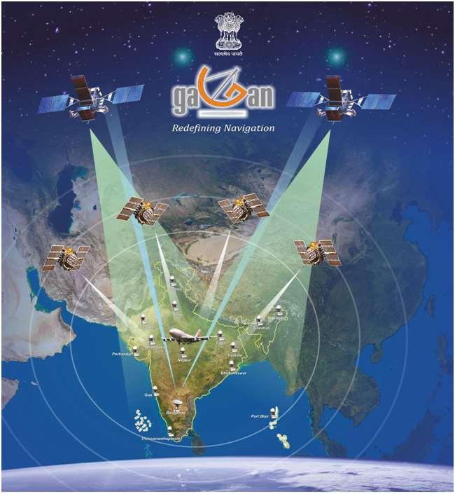
4 GAGAN A brief Profile GAGAN (GPS Aided GEO Augmented Navigation) - Indian SBAS Jointly developed by the AAI and ISRO (ISRO) Continuous operations since December 2013 (RNP 0.1) and April 2015 (APV 1) Current Transmission on GSAT-8 (PRN-127) & GSAT-10 (PRN-128) Third GEO satellite GSAT-15 (PRN 132) is being integrated in the current system India is the 4th country to implement Satellite Based Navigation System (GAGAN) USA, Japan and Europe Already implemented Russia, China and Korea In process of implementing Australia, Africa and Middle East Planning for implementation 3rd to achieve Approach with Vertical Guidance Certification 1st system developed in Equatorial Region making India the leader in Asia Pacific Region
5 GAGAN Advantages Limitations of GPS Integrity: not guaranteed, since all satellites may not be satisfactorily working all times. Time to alarm: could be from minutes to hours and there is no indication of quality of service. Accuracy: is not sufficient. vertical accuracy for 95% of the time is >10m to 100m. Availability & Continuity are not assured. GAGAN provides remedies to above problems Transmits correction messages to Users through GEO satellite
6 GPS v/s GAGAN Parameters GPS GAGAN Accuracy : GPS accuracy is based on the Provides (confirmation with respect to established truth) Integrity: (Confirmation with respect to, use or not to use based on quality of data received) geodetic location of user/receiver position and also it varies with time. (Due to un accounted errors involved ). Around meters Can t provide Integrity information on Real Time and also not guaranteed by the service provider. User will get alert which varies from minutes to hours. Improved accuracy by applying corrections on any given user / Receiver position and consistent with time. Less than 2 meters Provides Real Time Integrity information to user and guaranteed by the service provider. User will get alert within 6.2 sec.
7 Horizontal Position Error (HPE) at Kolkata INRES site Performance of a Receiver (GPS v/s GAGAN)
")
8 Vertical Position Error (VPE) at Kolkata INRES site Performance of a Receiver (GPS v/s GAGAN)


9 GAGAN Services GAGAN provides the following air navigation services as per ICAO SARPS. - RNP 0.1 within India FIR - APV-1 in the landmass of Indian FIR. GAGAN is useful in aviation and non-aviation sectors (i.e. sectors requiring accurate location information)
10 GAGAN Architecture GSAT-8 GSAT-10 GSAT-15 SIS with PRN 127 GPS 1 to 32 SIS with PRN 128 INLUS #1 PRN 127(BG) INLUS #2 PRN128 (BG) INLUS #3 PRN 127 (DD) DATA COMMUNICATION 2 Mbps / 128 Kbps DATA COMMUNICATION 2 Mbps / 128 Kbps (OFC Link) INMCC #1 (BG) INMCC #2 (BG) INMCC #3 (DEL) DATA COMMUNICATION 128 Kbps (OFC & V Sat Dual Link) INRES-1 INRES-2 INRES-15
11 A. Ground segment 1. Reference stations (INRES) - 15 Nos 2. Master Control Center (INMCC) - 3 Nos 3. Uplink Stations (INLUS)- 3 Nos 4. Redundant data links between GAGAN sites. Jaisalmer Jammu Delhi Gaya GAGAN GAGAN Elements - INRES Sites Dibrugarh Guwahati Patna Porbandar Ahmedabad Nagpur Calcutta Bhubaneswar B. Space segment 1. GPS Constellation 2. GEO Satellites with nav payload 3 no s C. User segment GAGAN enabled SBAS Rx. GOA Bangalore Port Blair Trivandrum


12 GAGAN Infrastructure 1 2 INMCC CTF BUILDING AT BANGALORE INLUS 11 MTR ANTENNA AT BANGALORE 3 INRES Facility At Bangalore 1 VSAT ANTENNA (6.3M DIA) AT BANGALORE
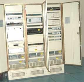
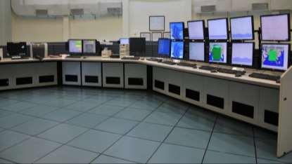
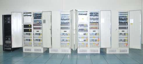
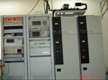
13 GAGAN Functional Components INMCC CVSS and DCSS INLUS

14 GAGAN Reference Facility


15 Typical plots of one day GAGAN Service availability APV-1 Service RNP 0.1 Service
16 GAGAN utilization in India Aviation Sector As per National Civil Aviation Policy (NCAP-2016), Ministry of Civil Aviation, India mandated that: All new aircraft, registered in India to be GAGAN enabled from 1 st January Forward fit notification issued by DGCA. All aircraft, registered in India, to be GAGAN enabled from Completed design and development of 5 GAGAN LPV procedures at 3 airports Testing & validation of these procedures in progress. Development of APV procedures for 20 Airports are in the progress. In the next few years, GAGAN APV procedures development for almost all operational airports in India.


17 GAGAN services to neighboring countries GAGAN GEO footprint expands from Africa to Australia and have expansion capability for seamless navigation services for the region. GAGAN is also interoperable with other SBAS systems like WAAS, EGNOS and MSAS.

18 Coverage Area of GAGAN services APV1 RNP0.1

19 GAAGN RNP 0.1 Coverage beyond the Indian Region
20 Non- Aviation uses of GAGAN GAGAN can be used for non-aviation applications, such as : Survey/Mapping Railways Marine applications Scientific research Location Based Services etc
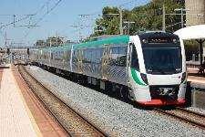
21 Utilization of GAGAN in Non aviation sector 1. Workshops organized with non-aviation sectors such as Roadways, Railways, Agriculture, Disaster Management, Maritime, Utilities, Power and Telecom. 2. These sectors are willing to use GAGAN for location based applications and shall take steps for its implementation. 3. Ministry of Road Transport and Highways has already mandated using GAGAN for vehicle tracking applications under the Automotive Standards. 4. Indian Railways procured GAGAN enabled dongles for testing its accuracy for the Geographical Information System (GIS) project. 5. AAI working on utilizing GAGAN signals for broadcasting of short messages as GAGAN Message Service (GAMES)
22 Uses & Benefits of GAGAN for Surveying / GIS Accurate source of GPS L1 corrections With a high performance GAGAN enabled receiver and a good quality antenna, consistent positioning under 1mtr can be achieved in real time. No base station is needed, so it can work in vast inland regions and open sea No user fee Nationwide coverage Excellent ergonomics ( no additional hardware) Very reliable
23 GAGAN MESSAGE SERVICE (GAMES) AAI is working to utilize GAGAN signals for broadcasting short service messages via GEO satellites. Broadcast early warning messages on the occurrence of natural disasters, calamities, dangers for the safety of life within GAGAN coverage area : Search and Rescue Messages Relief and mitigation related messages Meteorological information Users having the possibility to process the messages can extract the enclosed information and use it in the way they need.
24 Advantages of GAGAN Message services Free Service. Users equipped with GAGAN enables receivers know their position along with alerts. Confirmation of transmission and timely delivery of message is guaranteed as GAGAN is basically a SoL system Service availability ensured all the time Wider coverage area No additional requirement for local infrastructure Low operational cost Capability to support different type of alerts simultaneously
25 Opportunities for Neighboring States States Neighboring states can take advantage of GAGAN signals utilization in aviation and non aviation sectors in the respective states with minimal expenditure. AAI, as GAGAN service provider has the capability to : install reference stations. train personnel. integrate reference station data with Indian Master Control center and uplink the same via GEOs GSAT 8, 10 & 15 for SBAS services over the selected country.

26 Thank you
27 Railways Roads DoT CRIS is working on Real Time tracking of train movements Real Time Train Information System (RTIS) shall be using GAGAN for location data Working on pilot project Road Asset Management (RAMS) using GAGAN satellite RAMS funded by World Bank for 3,000 km of national highways NHAI sought funds from World Bank to collect data for 97,000 km of National Highways Examining feasibility of shifting timing reference of Telecom networks to GAGAN. Power Indicated willingness to shift to GAGAN as the timing reference for Critical National Infrastructure Shipping Ministry would promulgate GAGAN as being an approved SBAS for Dynamic Positioning, Pilotage and other marine uses Advantages of GAMES to be explored
28 HQ IDS DIETY Would specify WAAS enabled criteria for positioning units being procured for armed forces [Integrated Defense Staff ] Examine feasibility of inclusion of GAGAN as positioning system in standards notified for equipment manufacturers Agro NDMA MNCFC specified need for pilot project to quantify real time GAGAN benefits Interested to explore GAGAN for Crop Insurance (KISAN) project and precision farming applications Interested to utilize GAMES for disaster relief and post-disaster coordination Conduct pilot project to quantify real time benefits of GAMES DGLL Exploring Satellite based Automatic Identification System (AIS) and Vessel Traffic Management System Upgrading 13 stations with space technology
29 Manufacturers of survey grade GNSS receivers/ Total Station Trimble Garmin Leica Spectra Precision JAVAD Magellan Novatel Accord Stesalit
30 DGPS v/s GAGAN GEO Differential GPS (DGPS) is the most widely used technique for accurate positioning in Surveying. GAGAN is the NATIONWIDE DGPS system, which does not require any DGPS reference station or Modem. DGPS position errors grow proportional to the distance between the DGPS reference station and the user receiver. GAGAN provides better accuracy uniformly compared to DGPS and is most suitable for Surveying. GAGAN signals can be used for Static Surveys, Dynamic Surveys and Real Time Dynamic Surveys.
GAGAN-Extension to the Gulf Region. Joint ACAC/ICAO MID Workshop on GNSS 7 th & 8 th November 2017
 GAGAN-Extension to the Gulf Region Joint ACAC/ICAO MID Workshop on GNSS 7 th & 8 th November 2017 P.N.S. KUSHWAHA EXECUTIVE DIRECTOR (CNS P) Airports Authority of India New Delhi Topics covered : 1. GAGAN
GAGAN implementation and certification Programme. Presented by India
 GAGAN implementation and certification Programme Presented by India GPS Aided Geo Augmented Navigation International Civil Aviation Organization (ICAO) Member States Endorsed Global Satellite Navigation
Indian Regional Navigation Satellite System (IRNSS) / Navigation with Indian Constellation (NavIC) and GPS Aided Geo Augmented Navigation (GAGAN)
 / Navigation with Indian Constellation (NavIC) and GPS Aided Geo Augmented Navigation (GAGAN)") Indian Regional Navigation Satellite System (IRNSS) / Navigation with Indian Constellation (NavIC) and GPS Aided Geo Augmented Navigation (GAGAN) IRNSS-1A Gsat-8 IRNSS 7 November, 2016 Nilesh M. Desai
Indian Regional Navigation Satellite System (IRNSS) / Navigation with Indian Constellation (NavIC) and GPS Aided Geo Augmented Navigation (GAGAN) IRNSS-1A Gsat-8 IRNSS 7 November, 2016 Nilesh M. Desai
SATELLITE BASED AUGMENTATION SYSTEM (SBAS) FOR AUSTRALIA
 FOR AUSTRALIA") SATELLITE BASED AUGMENTATION SYSTEM (SBAS) FOR AUSTRALIA AN AIN POSITION PAPER SUBMITTED TO VARIOUS GOVERNMENT DEPARTMENTS BY MR KYM OSLEY AM, CSC, EXEC SECRETARY AIN What are GNSS Augmentation Systems?
SATELLITE BASED AUGMENTATION SYSTEM (SBAS) FOR AUSTRALIA AN AIN POSITION PAPER SUBMITTED TO VARIOUS GOVERNMENT DEPARTMENTS BY MR KYM OSLEY AM, CSC, EXEC SECRETARY AIN What are GNSS Augmentation Systems?
Dr. Mahesh Sharma Minister of State, Civil Aviation
 The First GNSS NEWS LETTER Jointly produced by ISRO and AAI To mark the Dedication of GAGAN to Aviation Shri P. Ashok Gajapathi Raju Minister of Civil Aviation Dr. Mahesh Sharma Minister of State, Civil
Indian GNSS Industry Overview Challenges and future prospects
 Indian GNSS Industry Overview Challenges and future prospects Expert Presentation By Dr. S.V. Kibe Consultant, SATCOM & GNSS, Bangalore, India (Former Programme Director, SATNAV,ISRO HQ) On February 20,2013
Nigerian Communications Satellite Ltd. (NIGCOMSAT)
") OVERVIEW OF NIGERIAN SATELLITE AUGMENTATION SYSTEM COMMENCING WITH PILOT DEMONSTRATION TO VALIDATE NATIONAL WORK PLAN presented by Dr. Lawal Lasisi Salami, NIGERIAN COMMUNICATIONS SATELLITE LTD UNDER FEDERAL
OVERVIEW OF NIGERIAN SATELLITE AUGMENTATION SYSTEM COMMENCING WITH PILOT DEMONSTRATION TO VALIDATE NATIONAL WORK PLAN presented by Dr. Lawal Lasisi Salami, NIGERIAN COMMUNICATIONS SATELLITE LTD UNDER FEDERAL
Lecture-1 CHAPTER 2 INTRODUCTION TO GPS
 Lecture-1 CHAPTER 2 INTRODUCTION TO GPS 2.1 History of GPS GPS is a global navigation satellite system (GNSS). It is the commonly used acronym of NAVSTAR (NAVigation System with Time And Ranging) GPS (Global
SBAS solution GCC, Yemen and Iraq System baseline and performance
 SBAS solution GCC, Yemen and Iraq System baseline and performance ACAC Workshop Rabat 7 & 8 November 2017 1 2017 Thales Alenia Space PROPRIETARY C O M MINFORMATION E R C I A L I N THALES C O ALENIA N F
Status of the European EGNOS and Galileo Programmes. Frank Udnaes Galileo policy and Infrastructure group EC DG-TREN. June 2008
 Status of the European EGNOS and Galileo Programmes Frank Udnaes Galileo policy and Infrastructure group EC DG-TREN EUROPEAN COMMISSION z June 2008 Galileo An infrastructure 30 satellite Constellation
Precise Positioning... what does it mean? Precise GNSS Positioning Not just a niche technology. Chris Rizos 15/12/15
 Precise GNSS Positioning Not just a niche technology Chris Rizos Precise Positioning... what does it mean? 1 Precise Positioning... a spectrum of users... Few mm 1cm 2cm < dm 1dm sub-m Precision agriculture
Aviation Benefits of GNSS Augmentation
 Aviation Benefits of GNSS Augmentation Workshop on the Applications of GNSS Chisinau, Moldova 17-21 May 2010 Jeffrey Auerbach Advisor on GNSS Affairs Office of Space and Advanced Technology U.S. Department
Overview of the global GNSS market and status of Galileo
 2012 GNSS.asia workshop Overview of the global GNSS market and status of Galileo 6 November, 2012 Taipei Justyna Redelkiewicz, European GNSS Agency European GNNS Agency supports European Commission in
INTERNATIONAL CIVIL AVIATION ORGANIZATION
 INTERNATIONAL CIVIL AVIATION ORGANIZATION AFI PLANNING AND IMPLEMENTATION REGIONAL GROUP EIGHTEENTH MEETING (APIRG/18) Kampala, Uganda (27 30 March 2012) Agenda Item 3: Performance Framework for Regional
Protection Augmentation Toughness and Alternatives of GNSS. Melaha 2016 Concord Al-Salam Hotel Cairo, April 25,2016 Refaat Rashad
 Protection Augmentation Toughness and Alternatives of GNSS Melaha 2016 Concord Al-Salam Hotel Cairo, April 25,2016 Refaat Rashad Road Map of the Presentation 1- How Good are GNSS 2- How Vulnerable are
One Source for Positioning Success
 novatel.com One Source for Positioning Success RTK, PPP, SBAS OR DGNSS. NOVATEL CORRECT OPTIMIZES ALL CORRECTION SOURCES, PUTTING MORE POWER, FLEXIBILITY AND CONTROL IN YOUR HANDS. NovAtel CORRECT is the
EGNOS status and performance in the context of marine navigation requirements
 EGNOS status and performance in the context of marine navigation requirements J. Cydejko Gdynia Maritime University, Gdynia, Poland ABSTRACT: The current status of EGNOS (December 2006) is described as
Technical Specifications Document. for. Satellite-Based Augmentation System (SBAS) Testbed
 Testbed") Technical Specifications Document for Satellite-Based Augmentation System (SBAS) Testbed Revision 3 13 June 2017 Table of Contents Acronym Definitions... 3 1. Introduction... 4 2. SBAS Testbed Realisation...
Technical Specifications Document for Satellite-Based Augmentation System (SBAS) Testbed Revision 3 13 June 2017 Table of Contents Acronym Definitions... 3 1. Introduction... 4 2. SBAS Testbed Realisation...
GPS/WAAS Program Update
 GPS/WAAS Program Update UN/Argentina Workshop on the Applications of GNSS 19-23 March 2018 Cordoba, Argentina GNSS: A Global Navigation Satellite System of Systems Global Constellations GPS (24+3) GLONASS
The EU Satellite Navigation programmes status Applications for the CAP
 The EU Satellite Navigation programmes status Applications for the CAP Michaël MASTIER European Commission DG ENTR GP3 GNSS Applications, Security and International aspects GPS Workshop 2010 Montpellier
ICAO policy on GNSS, GNSS SARPs and global GNSS developments. Jim Nagle Chief, Communication, Navigation and Surveillance Section ICAO
 ICAO policy on GNSS, GNSS SARPs and global GNSS developments Jim Nagle Chief, Communication, Navigation and Surveillance Section ICAO Presentation overview Introduction GNSS developments in ICAO ICAO policy
Een GPS naderingshulpmiddel voor de kleine luchtvaart
 Technische ontwikkelingen: Een GPS naderingshulpmiddel voor de kleine luchtvaart Christian Tiberius Faculteit Luchtvaart- en Ruimtevaarttechniek TU Delft WORKSHOP Is er nog Lucht(ruim) voor de Kleine Luchtvaart
Indian GNSS Paradigm A.S.GANESHAN. Program Director - SATNAV ISAC/ISRO, Bangalore. SCPNT Nov.2015 STANFORD PALOALTO 1
 Indian GNSS Paradigm Dr. S. PAL [FIEEE, FNAE, FNASc, Dist. Fellow IETE, IET(UK), MIAA(Paris)] Vice Chancellor Defence Ins6tute of Advanced Technology, (Deemed University), Girinagar, Pune 411025 (Former
GNSS: CNS Dependencies
 GNSS: CNS Dependencies Lendina Smaja DATM/RDS/NAV 10 March 2015 Agenda The Future Technical Environment GNSS GNSS Supporting CNS Loss of Signal Impact GNSS: CNS Dependencies 2 Original FANS CNS/ATM Concept
Development of BeiDou Navigation Satellite System
 The 8 th Meeting of the International Committee on GNSS Development of BeiDou Navigation Satellite System China Satellite Navigation Office Dubai, UAE November, 2013 Contents Contents 1. Objectives and
REPORT OF COMMITTEE B TO THE CONFERENCE ON AGENDA ITEM 6
 1/10/03 ELEVENTH AIR NAVIGATION CONFERENCE Montreal, 22 September to 3 October 2003 REPORT OF COMMITTEE B TO THE CONFERENCE ON AGENDA ITEM 6 The attached report has been approved by Committee B for submission
Global Navigation Satellite System and Augmentation
 Global Navigation Satellite System and Augmentation KCTSwamy Knowing about Global Navigation Satellite System (GNSS) is imperative for engineers, scientists as well as civilians because of its wide range
GBAS FOR ATCO. June 2017
 GBAS FOR ATCO June 2017 Disclaimer This presentation is for information purposes only. It should not be relied on as the sole source of information, and should always be used in the context of other authoritative
EGNOS Operations Oper and T and heir T Planned Ev E olution v
 EGNOS Operations a Th P Evo EGNOS Laurent Gauthier, Javier Ventura-Traveset, Felix Toran Navigation Department, ESA Directorate of European Union and Industrial Programmes, Toulouse, France Chantal de
CONSIDERATIONS FOR GNSS MEASUREMENTS
 CONSIDERATIONS FOR GNSS MEASUREMENTS Cornel PĂUNESCU 1, Cristian VASILE 2, Cosmin CIUCULESCU 3 1 PhD University of Bucharest, e-mail: cornelpaun@gmail.com 2 Lecturer PhD University of Craiova, cristi_vasile_4you@yahoo.com
Galileo & EGNOS Programmes Status
 Galileo & EGNOS Programmes Status Ugo Celestino, European Commission EURO-MEDITERRANEAN TRANSPORT FORUM GNSS WORKING GROUP 16 th October 2012 17 October, 2012 The European GNSS Programmes 2 Table of contents
ASSEMBLY 37TH SESSION
 International Civil Aviation Organization WORKING PAPER A37-WP/195 1 22/9/10 (Information paper) ASSEMBLY 37TH SESSION TECHNICAL COMMISSION Agenda Item 35: The Global Air Traffic Management (ATM) System
Satellite-Based Augmentation System (SBAS) Integrity Services
 Integrity Services") Satellite-Based Augmentation System (SBAS) Integrity Services Presented To: Munich, Germany Date: March 8, 2010 By: Leo Eldredge, Manager GNSS Group, FAA FAA Satellite Navigation Program 2 Wide Area Augmentation
Satellite-Based Augmentation System (SBAS) Integrity Services Presented To: Munich, Germany Date: March 8, 2010 By: Leo Eldredge, Manager GNSS Group, FAA FAA Satellite Navigation Program 2 Wide Area Augmentation
EC UA Aviation Conference, Windhoek, Namibia, April 2 & 3, 2009
 EC UA Aviation Conference, Windhoek, Namibia, April 2 & 3, 2009 Session 7 : EU-Africa Civil Aviation Co-operation 1 Contents Page 2 Who is Thales Alenia Space Thales Alenia Space contribution to Air Traffic
Introduction to the Global Positioning System
 GPS for Fire Management - 2004 Introduction to the Global Positioning System Pre-Work Pre-Work Objectives Describe at least three sources of GPS signal error, and identify ways to mitigate or reduce those
Radio Navigation Aids Flight Test Seminar
 Radio Navigation Aids Flight Test Seminar FLIGHT INSPECTION IN THE NEW MILLENNIUM Curt Keedy FAA Flight Inspection Policy and Standards Change, Challenge, and Opportunity CHANGES Global Positioning system
ORBCOMM Machine-To-Machine (M2M)
") ORBCOMM Machine-To-Machine (M2M) Texas V & C-Sigma November 2012 Global M2M Connecting the World s Assets Machine-To-Machine (M2M) Applications Global M2M Wireless Network for Narrowband Data Applications
ORBCOMM Machine-To-Machine (M2M) Texas V & C-Sigma November 2012 Global M2M Connecting the World s Assets Machine-To-Machine (M2M) Applications Global M2M Wireless Network for Narrowband Data Applications
Dimov Stojče Ilčev. CNS Systems
 Stratospheric Platform Systems (SPS) Presentation by: Dimov Stojče Ilčev Durban University of Technology (DUT) Space Science Centre (SSC) CNS Systems August 2011 SPS for Mobile CNS Applications Stratospheric
The experimental evaluation of the EGNOS safety-of-life services for railway signalling
 Computers in Railways XII 735 The experimental evaluation of the EGNOS safety-of-life services for railway signalling A. Filip, L. Bažant & H. Mocek Railway Infrastructure Administration, LIS, Pardubice,
First broadcast of SBAS- SACCSA test signal in the Caribbean, Central America and South America
 IONGNSS 2011 September 19 th -23 th 2011 Portland, Oregon First broadcast of SBAS- SACCSA test signal in the Caribbean, Central America and South America Session C4: GNSS Space Based Augmentation Systems
Achievements January 2014 to January 2018
 Government of India Department of Space Indian Space Program - Highlights Achievements January 2014 to January 2018 16 February, 2018 Highlights of 4 year Achievements ISRO successfully accomplished 48
European Geostationary Navigation Overlay Service (EGNOS) Capability on Sirius 5 Satellite for SES
 Capability on Sirius 5 Satellite for SES") 21 October 2009 SES SIRIUS European Geostationary Navigation Overlay Service (EGNOS) Capability on Sirius 5 Satellite for SES Mike Pavloff, Executive Director, Space Systems/Loral Information included
21 October 2009 SES SIRIUS European Geostationary Navigation Overlay Service (EGNOS) Capability on Sirius 5 Satellite for SES Mike Pavloff, Executive Director, Space Systems/Loral Information included
European GNSS Evolution
 Ref. Ares(204)902599 - /06/204 European GNSS Evolution Hermann Ebner Galileo and EGNOS Programme Management DG Enterprise and Industry Content Introduction 2 2 Major Challenges for EGNSS Evolution 3 EGNSS
IMO WORLD-WIDE RADIONAVIGATION SYSTEM (WWRNS) GALILEO receiver performance standards. Submitted by the European Commission
 GALILEO receiver performance standards. Submitted by the European Commission") INTERNATIONAL MARITIME ORGANIZATION E IMO SUB-COMMITTEE ON SAFETY OF NAVIGATION 50th session Agenda item 13 2 April 2004 Original: ENGLISH WORLD-WIDE RADIONAVIGATION SYSTEM (WWRNS) GALILEO receiver performance
INTERNATIONAL MARITIME ORGANIZATION E IMO SUB-COMMITTEE ON SAFETY OF NAVIGATION 50th session Agenda item 13 2 April 2004 Original: ENGLISH WORLD-WIDE RADIONAVIGATION SYSTEM (WWRNS) GALILEO receiver performance
IMPLEMENTATION OF GNSS BASED SERVICES
 International Civil Aviation Organization IMPLEMENTATION OF GNSS BASED SERVICES Julio Siu Communications, Navigation and Surveillance Regional Officer ICAO NACC Regional Office ICAO Workshop on PBN Airspace
Introduction to GNSS opportunities in different Market Segments. Fiammetta Diani Market Development
 Introduction to GNSS opportunities in different Market Segments Fiammetta Diani Market Development fiammetta.diani@gsa.europa.eu 3-Mar-14 European GNSS Agency 2 Congratulations! Agenda European GNSS market
ICG 9 PRAGUE 10 November 2014
 ICG 9 PRAGUE 10 November 2014 GNSS and applications GNSS is technology powerfully enabler of a multitude of applications. Italy, recognizing that, have undertaken initiatives to develop pre-operational
GNSS Programme. Overview and Status in Europe
 GNSS Programme Overview and Status in Europe Inaugural Forum Satellite Positioning Research and Application Center 23 April 2007 Tokyo Presented by Thomas Naecke (European Commission) Prepared by Daniel
ORBITAL NAVIGATION SYSTEMS PRESENT AND FUTURE TENDS
 ORBITAL NAVIGATION SYSTEMS PRESENT AND FUTURE TENDS CONTENT WHAT IS COVERED A BRIEF HISTORY OF SYSTEMS PRESENT SYSTEMS IN USE PROBLEMS WITH SATELLITE SYSTEMS PLANNED IMPROVEMENTS CONCLUSION CONTENT WHAT
High Precision GNSS in Automotive
 High Precision GNSS in Automotive Jonathan Auld, VP Engineering and Safety 6, March, 2018 2 Global OEM Positioning Solutions and Services for Land, Sea, and Air. GNSS in Automotive Today Today the primary
Challenges and Solutions for GPS Receiver Test
 Challenges and Solutions for GPS Receiver Test Presenter: Mirin Lew January 28, 2010 Agenda GPS technology concepts GPS and GNSS overview Assisted GPS (A-GPS) Basic tests required for GPS receiver verification
Global Navigation Satellite System (GNSS) GPS Serves Over 400 Million Users Today. GPS is used throughout our society
 GPS Serves Over 400 Million Users Today. GPS is used throughout our society") Global avigation Satellite System (GSS) For freshmen at CKU AA December 10th, 2009 by Shau-Shiun Jan ICA & IAA, CKU Global avigation Satellite System (GSS) GSS (Global Positioning System, GPS) Basics Today
Global avigation Satellite System (GSS) For freshmen at CKU AA December 10th, 2009 by Shau-Shiun Jan ICA & IAA, CKU Global avigation Satellite System (GSS) GSS (Global Positioning System, GPS) Basics Today
Wide Area Augmentation System (WAAS)
") Wide Area Augmentation System (WAAS) Ionospheric Effects Symposium By: Jason Burns Technology Evolution Lead Date: Agenda WAAS Overview Ionospheric Effects on WAAS Future Plans User Segment Update 2 WAAS
Wide Area Augmentation System (WAAS) Ionospheric Effects Symposium By: Jason Burns Technology Evolution Lead Date: Agenda WAAS Overview Ionospheric Effects on WAAS Future Plans User Segment Update 2 WAAS
EGNOS/GALILEO Status. Rafael Lucas Navigation Applications and User Services Office European Space Agency
 EGNOS/GALILEO Status Rafael Lucas Navigation Applications and User Services Office European Space Agency Rafael.Lucas.Rodriguez@esa.int European Satellite Navigation Strategy GNSS1: EGNOS Civil complement
Principal Investigator Co-Principal Investigator Co-Principal Investigator Prof. Talat Ahmad Vice-Chancellor Jamia Millia Islamia Delhi
 Subject Paper No and Title Module No and Title Module Tag Geology Remote Sensing and GIS Concepts of Global Navigation Satellite RS & GIS XXXIII Principal Investigator Co-Principal Investigator Co-Principal
Greek Maritime trials
 Greek Maritime trials Liza Panagiotopoulou KTIMATOLOGIO S.A. Greek Maritime trials took place in the framework of GALILEO Future Applications GALA (Galileo Overall Architecture Definition) Work Package
Significance of instrumental biases and dilution of precision in the context of GAGAN
 Indian Journal of Radio & Space Physics Vol. 36, October 2007, pp. 405-410 Significance of instrumental biases and dilution of precision in the context of GAGAN Quddusa Sultana 1, Dhiraj Sunehra, D Venkata
CONCEPT OF OPERATIONS (CONOPS) FOR DUAL-FREQUENCY MULTI-CONSTELLATION (DFMC) GLOBAL NAVIGATION SATELLITE SYSTEM (GNSS)
 FOR DUAL-FREQUENCY MULTI-CONSTELLATION (DFMC) GLOBAL NAVIGATION SATELLITE SYSTEM (GNSS)") CONCEPT OF OPERATIONS (CONOPS) FOR DUAL-FREQUENCY MULTI-CONSTELLATION (DFMC) GLOBAL NAVIGATION SATELLITE SYSTEM (GNSS) Prepared by the ICAO Navigation Systems Panel CONOPS V6.4 Page 1 of 49 27 April 2018
CONCEPT OF OPERATIONS (CONOPS) FOR DUAL-FREQUENCY MULTI-CONSTELLATION (DFMC) GLOBAL NAVIGATION SATELLITE SYSTEM (GNSS) Prepared by the ICAO Navigation Systems Panel CONOPS V6.4 Page 1 of 49 27 April 2018
Initial Results of IRNSS Standalone and Hybrid Operations
 Initial Results of IRNSS Standalone and Hybrid Operations Anindya Bose Sujoy Mandal, Kousik Samanta, (Ms) Debipriya Dutta, Suvro Kundu, Atanu Santra Department of Physics, The University of Burdwan, India
The Role of Positioning Infrastructure in the Technological Future of the Profession by Matt Higgins
 The Role of Positioning Infrastructure in the Technological Future of our Profession Matt Higgins Vice President Presentation Outline An explanation of Positioning Infrastructure; The Economic and Environmental
One Decade of WAAS Lessons - How Would We Have Done It Differently, If Given Another Chance
 One Decade of WAAS Lessons - How Would We Have Done It Differently, If Given Another Chance Tim Schempp, WAAS Technical Director Dr. Kenneth Kung, Sr. Principal Engineering Fellow November 18, 2011 The
HORIZONTAL ARAIM AVAILABILITY FOR CIVIL AVIATION OPERATIONS. ARAIM Outreach event
 HORIZONTAL ARAIM AVAILABILITY FOR CIVIL AVIATION OPERATIONS ARAIM Outreach event Moses1978 copyright April 7, 2017 H-ARAIM availability for civil aviation operations 07/04/2017 1 INTRODUCTION Space Segment
IMPLEMENTATION OF AN SBAS-SACCSA TEST BED IN THE CAR/SAM REGIONS. (Presented by the Secretariat) SUMMARY
 SUMMARY") RLA/03/902 RCC/9 - WP/10 12/06/13 International Civil Aviation Organization South American Regional Office - Project RLA/03/902 Transition to GNSS/SBAS in the CAR/SAM Regions SACCSA Phase III Ninth Meeting
RLA/03/902 RCC/9 - WP/10 12/06/13 International Civil Aviation Organization South American Regional Office - Project RLA/03/902 Transition to GNSS/SBAS in the CAR/SAM Regions SACCSA Phase III Ninth Meeting
Introduction to the Global Positioning System
 GPS for ICS - 2003 Introduction to the Global Positioning System Pre-Work Pre-Work Objectives Describe at least three sources of GPS signal error, and ways to mitigate or reduce those errors. Identify
Understanding GPS: Principles and Applications Second Edition
 Understanding GPS: Principles and Applications Second Edition Elliott Kaplan and Christopher Hegarty ISBN 1-58053-894-0 Approx. 680 pages Navtech Part #1024 This thoroughly updated second edition of an
Prepared by Dr. Javier Ventura-Traveset
 Prepared by Dr. Javier Ventura-Traveset EGNOS Project Office. Toulouse (France). European Space Agency. EGNOS Receiver Manufacturers Workshop, Paris, ESA HQ, July 3, 2003 Page 1 EUROPEAN GNSS STRATEGY
The Wide Area Augmentation System (WAAS)
") The Wide Area Augmentation System (WAAS) Stanford University http://waas.stanford.edu !Aviation Metrics Outline!GPS/Aviation Timelines!The Wide-Area Augmentation System!Integrity Analyses!Comparison with
The Wide Area Augmentation System (WAAS) Stanford University http://waas.stanford.edu !Aviation Metrics Outline!GPS/Aviation Timelines!The Wide-Area Augmentation System!Integrity Analyses!Comparison with
Jun Shen International Cooperation Center. China Satellite Navigation Office
 Jun Shen (shenjun@beidou.gov.cn) International Cooperation Center Tenth Meeting of the International Committee on Global Navigation Satellite Systems (ICG) November 1-6, 2015 1 Introduction and Background
GPS/GNSS What is it? How Does it Work? What are its Applications?
 GPS/GNSS What is it? How Does it Work? What are its Applications? Historic Navigation Reference points in the sky used for navigation The Sun The Pole Star / North Star Southern Cross Gives Direction,
Introduction to PBN and RNP
 Introduction to PBN and RNP Rick Farnworth ATM/RDS/NAV SDM PBN workshop 19 th October 2017 Summary What is PBN? Some History The ICAO PBN Manual The Benefits of PBN Some Examples PBN Approaches PBN and
Update of BeiDou Navigation Satellite System
 Update of BeiDou Navigation Satellite System 01 03 Development Plan 02 Latest Progress Recent Plans 01 03 Development Plan 02 Development Objectives Basic Principles Development Steps Latest Progress System
Monitoring the EGNOS SYSTEM TEST BED at the Radio Navigation Experimentation Unit (RNEU)
") Monitoring the EGNOS SYSTEM TEST BED at the Radio Navigation Experimentation Unit (RNEU) ESTEC/ESA 2nd ESTB Workshop, Nice, 12th November 2001 What is the RNEU? Specialised facilities located at ESTEC/TOS-ET
Monitoring the EGNOS SYSTEM TEST BED at the Radio Navigation Experimentation Unit (RNEU) ESTEC/ESA 2nd ESTB Workshop, Nice, 12th November 2001 What is the RNEU? Specialised facilities located at ESTEC/TOS-ET
Regional and Inter-Regional Seminar and Workshop on Search and Rescue
 Regional and Inter-Regional Seminar and Workshop on Search and Rescue Mahe, Seychelles 19-22 July 2016 1 Agenda Aireon Introduction Space-Based ADS-B Overview Aireon System Deployment Status Aireon ALERT
Report of Working Group B: Enhancement of Global Navigation Satellite Systems Services Performance
 Report of : Enhancement of Global Navigation Satellite Systems Services Performance 1. The Working Group on Enhancement of Global Navigation Satellite Systems (GNSS) Service Performance (WG-B) of the International
Ground Based Augmentation Systems (GBAS) Introduction
 Introduction") Ground Based Augmentation Systems (GBAS) Introduction Technical and Operational Overview Andreas Lipp GBAS Implementation Workshop, ICAO EUR/NAT Paris, 18 March 2010 The European Organisation for the Safety
Ground Based Augmentation Systems (GBAS) Introduction Technical and Operational Overview Andreas Lipp GBAS Implementation Workshop, ICAO EUR/NAT Paris, 18 March 2010 The European Organisation for the Safety
Update on BeiDou Navigation Satellite System
 Update on BeiDou Navigation Satellite System 1 BDS Development 2 Near-term Plans BD-2 System FOC services from December, 2012 (5GEO+5IGSO+4MEO) Two on-orbit backup satellites launched in 2016 (1 IGSO+1
Introduction to NAVSTAR GPS
 Introduction to NAVSTAR GPS Charlie Leonard, 1999 (revised 2001, 2002) The History of GPS Feasibility studies begun in 1960 s. Pentagon appropriates funding in 1973. First satellite launched in 1978. System
Interoperability between EGNOS and WAAS: Tests Using ESTB and NSTB
 Interoperability between EGNOS and WAAS: Tests Using ESTB and NSTB Javier Ventura-Traveset, J.C. de Mateo (European Space Agency) Jorge Nieto, Ignacio García (GMV, S.A.) H. Delfour, J.M. Pieplu (ASPI)
Galileo as an instrument of unification of the European railway transport
 Railway Infrastructure Administration Galileo as an instrument of unification of the European railway transport by Hynek Mocek SŽDC, TÚDC - Laboratory of Intelligent Systems Pardubice,, Czech Republic
Comparison of Collision Avoidance Systems and Applicability to Rail Transport
 Comparison of Collision Avoidance Systems and Applicability to Rail Transport Cristina Rico García, Andreas Lehner, Thomas Strang and Matthias Röckl Institute of Communication and Navigation Page 1 Cristina
International Programmes & GNSS Monitoring
 International Programmes & GNSS Monitoring Patrizio Vanni (patrizio.vanni@enav.it) GNSS expert ICAO PBN and PANS-OPS Provisions Implementation workshop Lisbon, 26 August 2015 Participation to PBN/GNSS
Global navigation satellite systems (GNSS) - European Galileo system
 - European Galileo system") L E C T U R E 5 Global navigation satellite systems (GNSS) - European Galileo system Lecture 5 Overview Galileo GNSS Development Architecture Principle EGNOS GNSS applications GALILEO system GALILEO system
L E C T U R E 5 Global navigation satellite systems (GNSS) - European Galileo system Lecture 5 Overview Galileo GNSS Development Architecture Principle EGNOS GNSS applications GALILEO system GALILEO system
ESA/CNES/ARIANESPACE-Service Optique CSG, S. Martin ABUJA, OCTOBER 2018
 ESA/CNES/ARIANESPACE-Service Optique CSG, S. Martin ABUJA, OCTOBER 2018 GALILEO - SOME KEY FEATURES CIVIL Not managed by Defence DUAL FREQUENCY (L1/L5 ) Less impact from solar conditions/ionosphere DIGITAL
Current status of Quasi-Zenith Satellite System. Japan Aerospace Exploration Agency QZSS Project Team
 Current status of Quasi-Zenith Satellite System Japan Aerospace Exploration Agency QZSS Project Team 1 Quasi-Zenith Satellite System The QZSS is a regional space-based PNT (Positioning, Navigation and
CHC MINING DEFORMATION MONITORING SOLUTION
 CHC MINING DEFORMATION MONITORING SOLUTION Safety is first in mining. CHC offers solutions designed to improve safety for personnel on the ground and in the cab with 24/7 precision positioning for automatic
The Global Positioning Sytem II 10/19/2017
 The Global Positioning System II Field Experiments 10/19/2017 5-1 Mexico DGPS Field Campaign Cenotes in Tamaulipas, MX, near Aldama 10/19/2017 5-2 Are Cenote Water Levels Related? 10/19/2017 5-3 M. Helper,
GA and NextGen How technologies like WAAS and ADS-B will change your flying! Presented By Claire Kultgen
 GA and NextGen How technologies like WAAS and ADS-B will change your flying! Presented By Claire Kultgen Overview 1. TIS 2. ADS-B FIS-B TIS-B ADS-R 3. WAAS 4. T-Routes and GPS MEAs Questions Chat Pilot
General Assembly. United Nations A/AC.105/946
 United Nations A/AC.105/946 General Assembly Distr.: General 16 November 2009 Original: English Committee on the Peaceful Uses of Outer Space Report on the United Nations/Azerbaijan/United States of America/European
Satellite technology to prevent and respond in cases of maritime accidents
 United Nations International Conference on Space-based Technologies for Disaster Management "Disaster risk identification, assessment and monitoring" 23-25 October 2013, Beijing, China. Satellite technology
International Cooperation Research Center, China Satellite Navigation Office
 International Cooperation Research Center, ICG-8, Nov 10, 2013 Dubai Overview BeiDou Navigation Satellite System (hereinafter referred to as BDS") has provide regional service by the end of 2012, which
PRELIMINARY PROGRAMME
 ICG EXPERTS MEETING: GLOBAL NAVIGATION SATELLITE SYSTEMS SERVICES 14-18 December 2015 Vienna International Centre, Vienna, Austria Organized by International Committee on Global Navigation Satellite Systems
SBAS DFMC performance analysis with the SBAS DFMC Service Volume software Prototype (DSVP)
") SBAS DFMC performance analysis with the SBAS DFMC Service Volume software Prototype (DSVP) D. Salos, M. Mabilleau, Egis Avia C. Rodriguez, H. Secretan, N. Suard, CNES (French Space Agency) Email: Daniel.salos@egis.fr
SBAS DFMC performance analysis with the SBAS DFMC Service Volume software Prototype (DSVP) D. Salos, M. Mabilleau, Egis Avia C. Rodriguez, H. Secretan, N. Suard, CNES (French Space Agency) Email: Daniel.salos@egis.fr
The Wide Area Augmentation System
 The Wide Area Augmentation System Stanford University http://waas.stanford.edu What is Augmentation? 2 Add to GNSS to Enhance Service Improve integrity via real time monitoring Improve availability and
INITIATIVES FOR IMPROVEMENT OF HF COMMUNICATION IN INDIAN AIRSPACE (Presented by India)
") 12 th Meeting of Arabian Sea-Indian Ocean ATS Coordination Group ASIOACG/12) & 8 th Meeting of Indian Ocean Strategic Partnership to Reduce Emissions (INSPIRE/8) New Delhi, India, 20-21 September 2017
12 th Meeting of Arabian Sea-Indian Ocean ATS Coordination Group ASIOACG/12) & 8 th Meeting of Indian Ocean Strategic Partnership to Reduce Emissions (INSPIRE/8) New Delhi, India, 20-21 September 2017
Current Status of the Japanese Quasi-Zenith Satellite System (QZSS)
") Current Status of the Japanese Quasi-Zenith Satellite System (QZSS) 12 November 2008 Koji TERADA QZSS Project Manager Japan Aerospace Exploration Agency Contents Introduction Concept of the QZSS System
Current Status of the Japanese Quasi-Zenith Satellite System (QZSS) 12 November 2008 Koji TERADA QZSS Project Manager Japan Aerospace Exploration Agency Contents Introduction Concept of the QZSS System
INTEGRITY AND CONTINUITY ANALYSIS FROM GPS JULY TO SEPTEMBER 2016 QUARTERLY REPORT
 INTEGRITY AND CONTINUITY ANALYSIS FROM GPS JULY TO SEPTEMBER 2016 QUARTERLY REPORT Name Responsibility Date Signature Prepared by M Pattinson (NSL) 07/10/16 Checked by L Banfield (NSL) 07/10/16 Authorised
Challenges and Methods for Integrity Assurance in Future GNSS
 Challenges and Methods for Integrity Assurance in Future GNSS Igor Mozharov Division Head, Information and Analytical Center for PNT, Central Research Institute for Machine Building, Roscosmos igor.mozharov@mcc.rsa.ru
Performance Evaluation of Differential Global Navigation Satellite System with RTK Corrections
 IOSR Journal of Electronics and Communication Engineering (IOSR-JECE) e-issn: 2278-2834,p- ISSN: 2278-8735.Volume 9, Issue 2, Ver. VI (Mar - Apr. 2014), PP 43-47 Performance Evaluation of Differential
GE 113 REMOTE SENSING
 GE 113 REMOTE SENSING Topic 9. Introduction to Global Positioning Systems (GPS) and Other GNSS Technologies Lecturer: Engr. Jojene R. Santillan jrsantillan@carsu.edu.ph Division of Geodetic Engineering
A Survey on SQM for Sat-Nav Systems
 A Survey on SQM for Sat-Nav Systems Sudarshan Bharadwaj DS Department of ECE, Cambridge Institute of Technology, Bangalore Abstract: Reduction of multipath effects on the satellite signals can be accomplished