Acquisition of Aerial Photographs and/or Satellite Imagery
|
|
|
- Gabriel Russell
- 5 years ago
- Views:
Transcription


1 Acquisition of Aerial Photographs and/or Satellite Imagery Acquisition of Aerial Photographs and/or Imagery From time to time there is considerable interest in the purchase of special-purpose photography contracted through commercial survey firms. Even though commercial firm may have the technical expertise to handle almost any type of photographic mission, the client still may be responsible for: 1. defining objectives, 2. drawing up preliminary specifications or flight plans, 3. estimating costs, and 4. determining whether the finished product meets interpretation and mapping requirements. 1

2 Ground Coverage vs. Focal Length Variations In practice, the range of scales actually employed is usually from 1:1,000 to about 1:50,000. Where simultaneous coverage at two different scales is desired, certain aircraft can be fitted with two mapping cameras employing different focal-length lenses. Seasonal Considerations Data must meet the requirements of the project objectives. 1. Forest and vegetation 2. Geological and topographic mapping 3. Wetland survey 4. Urban planning 5. Forest study, for example, the best timing for infrared coverage is from mid-spring to early summer, a period when all trees have produced some foliage but before maximum leaf pigmentation. 2


3 Seasonal Considerations In the northern latitude the best results of true color imagery have been obtained in late fall, just before deciduous species, such as aspen and oak, shed their leaves. For a brief time period, foliage color differences will provide good tonal contrasts between most of the important tree species and communities. Leave on or off? With or without snow cover on the ground? 3


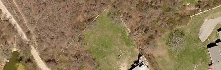
4 Seasonal Leaf-on vs. Leaf-off Seasonal Leaf-on vs. Leaf-off 4


5 Spring 2007, 6 spatial resolution Spring 2008, 4 spatial resolution 5

6 Facility Considerations vs. Other Requirements Weather condition, Airport facilities and distance to work area, Time windows Time-of-Day Consideration This is the consideration of shadow effects. The sun's elevation angle above the horizon is a function of latitude, season of the year, and the time of the day. When extensive shadowing is not wanted, ground scenes should be photographed within about two hours of local apparent noon (solar noon). 6

7 Time-of-Day Consideration A consequence of selecting the wrong combination of season and time of day is a phenomenon known as a hotspot, or sunspot. A loss of photographic detail with overexposed areas. Time-of-Day Consideration Hotspots are most likely to occur with certain sun-angles, at lower latitude, at higher flight altitudes, and with wide angle lenses. After the season and latitude of photography have been determined, it is possible to calculate and thus to avoid those times when hotspots will likely to occur. 7
8 Technical Specification for New Photography/Imagery Acquisition When the decision to purchase new photography/imagery has been made, technical specifications are usually detailed in a formal contract. The following items are usually covered to some degree in all contracts: Business Arrangements: include the cost of the aerial survey, a provision for periodic inspection of work completed, criteria for reflights, and schedules for delivery and payment Study Area: the tract to be photographed is accurately delineated on maps supplied by the client. Digital Products: Projections, atmospheric corrections, media types, Technical Specification for New Photography Flight Lines: Lines should be parallel, oriented in the correct direction, and within a stated distance from positions drawn on the flight maps. When possible, flight lines should run north-south or east-west. For maximum efficiency, they should parallel the long axis of the study area. As a margin of safety, an extra flight line should be added to each side of the study area to assure complete coverage. 8
9 Technical Specification for New Photography Overlap and Sidelap: For stereo coverage, overlap is usually 55 to 65 percent (average 60%) along the line of flight and 15 to 45 percent (average 20-30%) sidelap between adjacent flight lines. At the end of each flight line, two photos should be added as a margin of safety to assure total coverage. Technical Specification for New Photography Photo Alignment: Crab or drift should not affect more than 10 percent of the print width for any consecutive photographs. Tilt: Tilt should not exceed 2 o to 3 o for a single exposure or average more than 1 o for the entire project. 9
 should also be specified; cloud-free coverage is desirable for most mapping project.")
10 Technical Specification for New Photography Required Timing and Cloud Cover: Both season of year and optimum time of day are usually specified by the client. An allowable cloud cover (percent) should also be specified; cloud-free coverage is desirable for most mapping project. Flight-Plan Map: It is customary for a final version of the flight-plan map to be supplied to the client. It should show the actual locations of the flight lines and the photographic center points (exposure stations) along each line. Examples of Satellite Imagery Acquisition (for study areas in Jamaica Bay and Fire Island, NY 10


11 QuickBird-2 satellite imagery acquisition for Jamaica Bay, NY 11
 Displayed as bands 3, 2, 1")


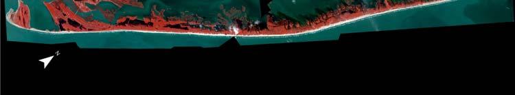
12 QuickBird Image (acquired September 10, 2003) Displayed as bands 3, 2, 1 in RGB QuickBird-2 satellite imagery acquisition for Fire Island National Seashore, NY April 8, 2004 April 16, 2004 May 6, 2004 May 4, 2004 April 8,


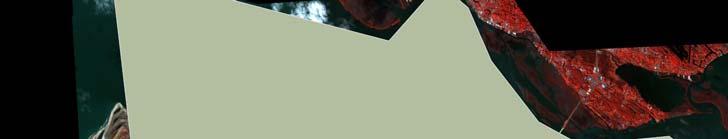
13 After geometric rectification and moasicking process October 16, 2016 October 11,


14 Tasking - AOI Importance of buffer 14


15 Data Acquisition Satellite Questions Bit Depth in DigitalGlobe case data is collected as 11 bits and delivered as 8 or 16 bits. Tiling 15


16 Cloud Cover Standard 15% cloud cover allowed Extra charge lower you desire Cloud Removal 16

17 Technical Specification for New Photography/Imagery (Con't) Inspection of Contract Photography Following the completion of a photographic survey, it is customary for the client, or a representative, to make a technical inspection of all photographic products. Acceptance or rejection often requires checks for such items as tilt, overlap, sidelap, scale, plus film and print quality. Photographic quality is the most difficult item to evaluate. Image acquired May 7 th (left) and October 10 th (right), in a location about 42 o N in same year 17
Acquisition of Aerial Photographs and/or Imagery
 Acquisition of Aerial Photographs and/or Imagery Acquisition of Aerial Photographs and/or Imagery From time to time there is considerable interest in the purchase of special-purpose photography contracted
MINNESOTA DEPARTMENT OF TRANSPORTATION OFFICE OF LAND MANAGEMENT SURVEYING AND MAPPING SECTION PHOTOGRAMMETRY UNIT
 SEP. 2011 MINNESOTA DEPARTMENT OF TRANSPORTATION OFFICE OF LAND MANAGEMENT SURVEYING AND MAPPING SECTION PHOTOGRAMMETRY UNIT SPECIAL PROVISIONS FOR: GROUP 1: AERIAL PHOTOGRAPHY/PHOTOGRAMMETRIC LAB SERVICES
Photogrammetry. Lecture 4 September 7, 2005
 Photogrammetry Lecture 4 September 7, 2005 What is Photogrammetry Photogrammetry is the art and science of making accurate measurements by means of aerial photography: Analog photogrammetry (using films:
MONITORING RUBBLE-MOUND COASTAL STRUCTURES WITH PHOTOGRAMMETRY
 ,. CETN-III-21 2/84 MONITORING RUBBLE-MOUND COASTAL STRUCTURES WITH PHOTOGRAMMETRY INTRODUCTION: Monitoring coastal projects usually involves repeated surveys of coastal structures and/or beach profiles.
CEE 6100 / CSS 6600 Remote Sensing Fundamentals 1 Topic 4: Photogrammetry
 CEE 6100 / CSS 6600 Remote Sensing Fundamentals 1 PHOTOGRAMMETRY DEFINITION (adapted from Manual of Photographic Interpretation, 2 nd edition, Warren Philipson, 1997) Photogrammetry and Remote Sensing:
Sample Copy. Not For Distribution.
 Photogrammetry, GIS & Remote Sensing Quick Reference Book i EDUCREATION PUBLISHING Shubham Vihar, Mangla, Bilaspur, Chhattisgarh - 495001 Website: www.educreation.in Copyright, 2017, S.S. Manugula, V.
Volume 1 - Module 6 Geometry of Aerial Photography. I. Classification of Photographs. Vertical
 RSCC Volume 1 Introduction to Photo Interpretation and Photogrammetry Table of Contents Module 1 Module 2 Module 3.1 Module 3.2 Module 4 Module 5 Module 6 Module 7 Module 8 Labs Volume 1 - Module 6 Geometry
Basics of Photogrammetry Note#6
 Basics of Photogrammetry Note#6 Photogrammetry Art and science of making accurate measurements by means of aerial photography Analog: visual and manual analysis of aerial photographs in hard-copy format
Flood modelling and management. Glasgow University. 8 September Paul Shaw - GeoVision
 Flood modelling and management Glasgow University 8 September 2004 Paul Shaw - GeoVision How important are heights in flood modelling? Comparison of data collection technologies GPS - Global Positioning
PHOTOGRAMMETRY STEREOSCOPY FLIGHT PLANNING PHOTOGRAMMETRIC DEFINITIONS GROUND CONTROL INTRODUCTION
 PHOTOGRAMMETRY STEREOSCOPY FLIGHT PLANNING PHOTOGRAMMETRIC DEFINITIONS GROUND CONTROL INTRODUCTION Before aerial photography and photogrammetry became a reliable mapping tool, planimetric and topographic
CanImage. (Landsat 7 Orthoimages at the 1: Scale) Standards and Specifications Edition 1.0
 Standards and Specifications Edition 1.0") CanImage (Landsat 7 Orthoimages at the 1:50 000 Scale) Standards and Specifications Edition 1.0 Centre for Topographic Information Customer Support Group 2144 King Street West, Suite 010 Sherbrooke, QC
CanImage (Landsat 7 Orthoimages at the 1:50 000 Scale) Standards and Specifications Edition 1.0 Centre for Topographic Information Customer Support Group 2144 King Street West, Suite 010 Sherbrooke, QC
MSB Imagery Program FAQ v1
 MSB Imagery Program FAQ v1 (F)requently (A)sked (Q)uestions 9/22/2016 This document is intended to answer commonly asked questions related to the MSB Recurring Aerial Imagery Program. Table of Contents
An Introduction to Geomatics. Prepared by: Dr. Maher A. El-Hallaq خاص بطلبة مساق مقدمة في علم. Associate Professor of Surveying IUG
 An Introduction to Geomatics خاص بطلبة مساق مقدمة في علم الجيوماتكس Prepared by: Dr. Maher A. El-Hallaq Associate Professor of Surveying IUG 1 Airborne Imagery Dr. Maher A. El-Hallaq Associate Professor
Remote Sensing Platforms
 Types of Platforms Lighter-than-air Remote Sensing Platforms Free floating balloons Restricted by atmospheric conditions Used to acquire meteorological/atmospheric data Blimps/dirigibles Major role - news
11/25/2009 CHAPTER THREE INTRODUCTION INTRODUCTION (CONT D) THE AERIAL CAMERA: LENS PHOTOGRAPHIC SENSORS
 THE AERIAL CAMERA: LENS PHOTOGRAPHIC SENSORS") INTRODUCTION CHAPTER THREE IC SENSORS Photography means to write with light Today s meaning is often expanded to include radiation just outside the visible spectrum, i. e. ultraviolet and near infrared
INTRODUCTION CHAPTER THREE IC SENSORS Photography means to write with light Today s meaning is often expanded to include radiation just outside the visible spectrum, i. e. ultraviolet and near infrared
DRAPP Product QAQC Participating Partner Process Guidelines Steve Ashbee ASPRS Certified Photogrammetrist PMI Project Management Professional Sanborn
 DRAPP Product QAQC Participating Partner Process Guidelines Steve Ashbee ASPRS Certified Photogrammetrist PMI Project Management Professional Sanborn Program Manager Area naming and other general feedback
Orthoimagery Standards. Chatham County, Georgia. Jason Lee and Noel Perkins
 1 Orthoimagery Standards Chatham County, Georgia Jason Lee and Noel Perkins 2 Table of Contents Introduction... 1 Objective... 1.1 Data Description... 2 Spatial and Temporal Environments... 3 Spatial Extent
IKONOS High Resolution Multispectral Scanner Sensor Characteristics
 High Spatial Resolution and Hyperspectral Scanners IKONOS High Resolution Multispectral Scanner Sensor Characteristics Launch Date View Angle Orbit 24 September 1999 Vandenberg Air Force Base, California,
Aerial photography and Remote Sensing. Bikini Atoll, 2013 (60 years after nuclear bomb testing)
") Aerial photography and Remote Sensing Bikini Atoll, 2013 (60 years after nuclear bomb testing) Computers have linked mapping techniques under the umbrella term : Geomatics includes all the following spatial
Aerial photography and Remote Sensing Bikini Atoll, 2013 (60 years after nuclear bomb testing) Computers have linked mapping techniques under the umbrella term : Geomatics includes all the following spatial
Metro Area Planning Agency. Request for Proposal Omaha-Lincoln Metro Area Imagery Project
 Metro Area Planning Agency Request for Proposal 2018 Omaha-Lincoln Metro Area Imagery Project 1. General Info 1.1. Objective The Metro Area Planning Agency ( MAPA ) in Omaha is soliciting proposals from
2019 NYSAPLS Conf> Fundamentals of Photogrammetry for Land Surveyors
 2019 NYSAPLS Conf> Fundamentals of Photogrammetry for Land Surveyors George Southard GSKS Associates LLC Introduction George Southard: Master s Degree in Photogrammetry and Cartography 40 years working
Aerial Photo Interpretation
 Aerial Photo Interpretation Aerial Photo Interpretation To date, course has focused on skills of photogrammetry Scale Distance Direction Area Height There s another side to Aerial Photography: Interpretation
North Carolina Property Mappers Association
 North Carolina Property Mappers Association SECTION 1 AERIAL PHOTOGRAMMETRY 1.1 Introduction Photogrammetry is defined by the American Society of Photogrammetry as the art, science, and technology of obtaining
Content Reviewer (CR) Swati Katiyar Senior Research Fellow, Birla Institute of Scientific Research, Jaipur Language Editor (LE)
 Swati Katiyar Senior Research Fellow, Birla Institute of Scientific Research, Jaipur Language Editor (LE)") Component-I(A) - Personal Details Role Name Affiliation Principal Investigator Prof.MasoodAhsanSiddiqui Department of Geography, JamiaMilliaIslamia, New Delhi Paper Coordinator, if any Dr. M P Punia Head,
Component-I(A) - Personal Details Role Name Affiliation Principal Investigator Prof.MasoodAhsanSiddiqui Department of Geography, JamiaMilliaIslamia, New Delhi Paper Coordinator, if any Dr. M P Punia Head,
CHAPTER 8 AERIAL PHOTOGRAPHS
 CHAPTER 8 AERIAL PHOTOGRAPHS An aerial photograph is any photograph taken from an airborne vehicle (aircraft, drones, balloons, satellites, and so forth). The aerial photograph has many uses in military
FLIGHT SUMMARY REPORT
 FLIGHT SUMMARY REPORT Flight Number: 97-011 Calendar/Julian Date: 23 October 1996 297 Sensor Package: Area(s) Covered: Wild-Heerbrugg RC-10 Airborne Visible and Infrared Imaging Spectrometer (AVIRIS) Southern
TRACS A-B-C Acquisition and Processing and LandSat TM Processing
 TRACS A-B-C Acquisition and Processing and LandSat TM Processing Mark Hess, Ocean Imaging Corp. Kevin Hoskins, Marine Spill Response Corp. TRACS: Level A AIRCRAFT Ocean Imaging Corporation Multispectral/TIR
FOR 474: Forest Inventory. FOR 474: Forest Inventory. Why do we Care About Forest Sampling?
 FOR 474: Forest Inventory 1. Advanced Forest Inventory The Need for Forest Sampling Brief Intro to Remote Sensing and GIS Readings: FOR 474: Forest Inventory Related Courses! FOR 274: Forest Measurements
The studies began when the Tiros satellites (1960) provided man s first synoptic view of the Earth s weather systems.
 provided man s first synoptic view of the Earth s weather systems.") Remote sensing of the Earth from orbital altitudes was recognized in the mid-1960 s as a potential technique for obtaining information important for the effective use and conservation of natural resources.
Remote sensing of the Earth from orbital altitudes was recognized in the mid-1960 s as a potential technique for obtaining information important for the effective use and conservation of natural resources.
High Resolution Sensor Test Comparison with SPOT, KFA1000, KVR1000, IRS-1C and DPA in Lower Saxony
 High Resolution Sensor Test Comparison with SPOT, KFA1000, KVR1000, IRS-1C and DPA in Lower Saxony K. Jacobsen, G. Konecny, H. Wegmann Abstract The Institute for Photogrammetry and Engineering Surveys
AERIAL PHOTOGRAPHS CHAPTER 8
 CHAPTER 8 AERIAL PHOTOGRAPHS An aerial photograph is any photograph taken from an airborne vehicle (aircraft, drones, balloons) satellites, and so forth). The aerial photograph has many uses in military
EXAMPLES OF TOPOGRAPHIC MAPS PRODUCED FROM SPACE AND ACHIEVED ACCURACY CARAVAN Workshop on Mapping from Space, Phnom Penh, June 2000
 EXAMPLES OF TOPOGRAPHIC MAPS PRODUCED FROM SPACE AND ACHIEVED ACCURACY CARAVAN Workshop on Mapping from Space, Phnom Penh, June 2000 Jacobsen, Karsten University of Hannover Email: karsten@ipi.uni-hannover.de
Introduction to Photogeology
 Geological Mapping 1 Academic Year 2016/2017 Introduction to Photogeology Igor Vlahović igor.vlahovic@rgn.hr Today we will say a little about basic photogeological analysis of terrain: about aerial photographs,
Atmospheric interactions; Aerial Photography; Imaging systems; Intro to Spectroscopy Week #3: September 12, 2018
 GEOL 1460/2461 Ramsey Introduction/Advanced Remote Sensing Fall, 2018 Atmospheric interactions; Aerial Photography; Imaging systems; Intro to Spectroscopy Week #3: September 12, 2018 I. Quick Review from
GEORGE M. JANES & ASSOCIATES. July 12, Sabrina Charney-Hull Planning Director Town of New Castle 200 South Greeley Avenue Chappaqua, NY 10514
 GEORGE M. JANES & ASSOCIATES PLANNING with TECHNOLOGY 250 EAST 87TH STREET NEW YORK, NY 10128 www.georgejanes.com T: 646.652.6498 F: 801.457.7154 E: george@georgejanes.com July 12, 2012 Sabrina Charney-Hull
High Resolution Multi-spectral Imagery
 High Resolution Multi-spectral Imagery Jim Baily, AirAgronomics AIRAGRONOMICS Having been involved in broadacre agriculture until 2000 I perceived a need for a high resolution remote sensing service to
Introduction of Satellite Remote Sensing
 Introduction of Satellite Remote Sensing Spatial Resolution (Pixel size) Spectral Resolution (Bands) Resolutions of Remote Sensing 1. Spatial (what area and how detailed) 2. Spectral (what colors bands)
Geo/SAT 2 INTRODUCTION TO REMOTE SENSING
 Geo/SAT 2 INTRODUCTION TO REMOTE SENSING Paul R. Baumann, Professor Emeritus State University of New York College at Oneonta Oneonta, New York 13820 USA COPYRIGHT 2008 Paul R. Baumann Introduction Remote
Important Missions. weather forecasting and monitoring communication navigation military earth resource observation LANDSAT SEASAT SPOT IRS
 Fundamentals of Remote Sensing Pranjit Kr. Sarma, Ph.D. Assistant Professor Department of Geography Mangaldai College Email: prangis@gmail.com Ph. No +91 94357 04398 Remote Sensing Remote sensing is defined
APPLICATIONS AND LESSONS LEARNED WITH AIRBORNE MULTISPECTRAL IMAGING
 APPLICATIONS AND LESSONS LEARNED WITH AIRBORNE MULTISPECTRAL IMAGING James M. Ellis and Hugh S. Dodd The MapFactory and HJW Walnut Creek and Oakland, California, U.S.A. ABSTRACT Airborne digital frame
NRS 415 Remote Sensing of Environment
 NRS 415 Remote Sensing of Environment 1 High Oblique Perspective (Side) Low Oblique Perspective (Relief) 2 Aerial Perspective (See What s Hidden) An example of high spatial resolution true color remote
Image Fusion. Pan Sharpening. Pan Sharpening. Pan Sharpening: ENVI. Multi-spectral and PAN. Magsud Mehdiyev Geoinfomatics Center, AIT
 1 Image Fusion Sensor Merging Magsud Mehdiyev Geoinfomatics Center, AIT Image Fusion is a combination of two or more different images to form a new image by using certain algorithms. ( Pohl et al 1998)
Introduction to Photogrammetry
 Introduction to Photogrammetry Presented By: Sasanka Madawalagama Geoinformatics Center Asian Institute of Technology Thailand www.geoinfo.ait.asia Content Introduction to photogrammetry 2D to 3D Drones
Peace Project Water Use Plan. Williston Air Photos and DEM. Reference: GMSWORKS #14. Williston Air Photos and DEM 2011
 Peace Project Water Use Plan Williston Air Photos and DEM Reference: GMSWORKS #14 Williston Air Photos and DEM 2011 Study Period: May 2011 to December 2011 Les Giles Transmission Engineering, Photogrammetry
Remote Sensing is the observation of the Earth from satellites or aircrafts.
 Remote Sensing? Remote Sensing is the observation of the Earth from satellites or aircrafts. Sensors mounted on these platforms capture images of the Earth that reveal features may or may not apparent
NON-PHOTOGRAPHIC SYSTEMS: Multispectral Scanners Medium and coarse resolution sensor comparisons: Landsat, SPOT, AVHRR and MODIS
 NON-PHOTOGRAPHIC SYSTEMS: Multispectral Scanners Medium and coarse resolution sensor comparisons: Landsat, SPOT, AVHRR and MODIS CLASSIFICATION OF NONPHOTOGRAPHIC REMOTE SENSORS PASSIVE ACTIVE DIGITAL
Contents Remote Sensing for Studying Earth Surface and Changes
 Contents Remote Sensing for Studying Earth Surface and Changes Anupma Prakash Day : Tuesday Date : September 26, 2008 Audience : AMIDST Participants What is remote sensing? How does remote sensing work?
INTRODUCTORY REMOTE SENSING. Geob 373
 INTRODUCTORY REMOTE SENSING Geob 373 Landsat 7 15 m image highlighting the geology of Oman http://www.satimagingcorp.com/gallery-landsat.html ASTER 15 m SWIR image, Escondida Mine, Chile http://www.satimagingcorp.com/satellite-sensors/aster.html
Project Planning and Cost Estimating
 CHAPTER 17 Project Planning and Cost Estimating 17.1 INTRODUCTION Previous chapters have outlined and detailed technical aspects of photogrammetry. The basic tasks and equipment required to create various
Baldwin and Mobile Counties, AL Orthoimagery Project Report. Submitted: March 23, 2016
 2015 Orthoimagery Project Report Submitted: Prepared by: Quantum Spatial, Inc 523 Wellington Way, Suite 375 Lexington, KY 40503 859-277-8700 Page i of iii Contents Project Report 1. Summary / Scope...
CHARACTERISTICS OF REMOTELY SENSED IMAGERY. Spatial Resolution
 CHARACTERISTICS OF REMOTELY SENSED IMAGERY Spatial Resolution There are a number of ways in which images can differ. One set of important differences relate to the various resolutions that images express.
Large Scale Photogrammetric Maps for Land Planning
 Large Scale Photogrammetric Maps for Land Planning A lva F. W arren Clyde E. Williams & Associates, Inc. South Bend, Indiana Introduction It is my purpose to give a brief explanation of the method of making
THE NATIONAL AERIAL PHOTOGRAPHY PROGRAM: AN AERIAL SYSTEM IN SUPPORT OF THE UNITED STATES SPATIAL DATA INFRASTRUCTURE
 THE NATIONAL AERIAL PHOTOGRAPHY PROGRAM: AN AERIAL SYSTEM IN SUPPORT OF THE UNITED STATES SPATIAL DATA INFRASTRUCTURE Donald L. Light U.S. Geological Survey MS 511 National Center Reston, Virginia 22092
Evaluation of FLAASH atmospheric correction. Note. Note no SAMBA/10/12. Authors. Øystein Rudjord and Øivind Due Trier
 Evaluation of FLAASH atmospheric correction Note Note no Authors SAMBA/10/12 Øystein Rudjord and Øivind Due Trier Date 16 February 2012 Norsk Regnesentral Norsk Regnesentral (Norwegian Computing Center,
Specifications for Aerial Photography
 Ministry of Agriculture and Lands Integrated Land Management Bureau Crown Registry and Geographic Base Branch Specifications for Aerial Photography Edition April 2008 Victoria BC Canadian Cataloguing in
HIGH RESOLUTION COLOR IMAGERY FOR ORTHOMAPS AND REMOTE SENSING. Author: Peter Fricker Director Product Management Image Sensors
 HIGH RESOLUTION COLOR IMAGERY FOR ORTHOMAPS AND REMOTE SENSING Author: Peter Fricker Director Product Management Image Sensors Co-Author: Tauno Saks Product Manager Airborne Data Acquisition Leica Geosystems
GIS Data Collection. Remote Sensing
 GIS Data Collection Remote Sensing Data Collection Remote sensing Introduction Concepts Spectral signatures Resolutions: spectral, spatial, temporal Digital image processing (classification) Other systems
ROLE OF SATELLITE DATA APPLICATION IN CADASTRAL MAP AND DIGITIZATION OF LAND RECORDS DR.T. RAVISANKAR GROUP HEAD (LRUMG) RSAA/NRSC/ISRO /DOS HYDERABAD
 RSAA/NRSC/ISRO /DOS HYDERABAD") ROLE OF SATELLITE DATA APPLICATION IN CADASTRAL MAP AND DIGITIZATION OF LAND RECORDS DR.T. RAVISANKAR GROUP HEAD (LRUMG) RSAA/NRSC/ISRO /DOS HYDERABAD WORKSHOP on Best Practices under National Land Records
ROLE OF SATELLITE DATA APPLICATION IN CADASTRAL MAP AND DIGITIZATION OF LAND RECORDS DR.T. RAVISANKAR GROUP HEAD (LRUMG) RSAA/NRSC/ISRO /DOS HYDERABAD WORKSHOP on Best Practices under National Land Records
Satellite Monitoring of a Large Tailings Storage Facility
 Satellite Monitoring of a Large Tailings Storage Facility Benjamin Schmidt and Matt Malgesini, Golder Associates Inc., USA Jim Turner, PhotoSat Ltd, Canada Jeff Reinson, Goldcorp Inc., Canada Presentation
Remote Sensing Platforms
 Remote Sensing Platforms Remote Sensing Platforms - Introduction Allow observer and/or sensor to be above the target/phenomena of interest Two primary categories Aircraft Spacecraft Each type offers different
Radar Imagery for Forest Cover Mapping
 Purdue University Purdue e-pubs LARS Symposia Laboratory for Applications of Remote Sensing 1-1-1981 Radar magery for Forest Cover Mapping D. J. Knowlton R. M. Hoffer Follow this and additional works at:
Remote sensing in archaeology from optical to lidar. Krištof Oštir ModeLTER Scientific Research Centre of the Slovenian Academy of Sciences and Arts
 Remote sensing in archaeology from optical to lidar Krištof Oštir ModeLTER Scientific Research Centre of the Slovenian Academy of Sciences and Arts Introduction Optical remote sensing Systems Search for
VERTICAL AERIAL PHOTOGRAPHY
 VERTICAL AERIAL PHOTOGRAPHY Mike Craig Cooperative Research Centre for Landscape Environments and Mineral Exploration, Geoscience Australia. PO Box 378, Canberra, ACT 2601. E-mail: mike.craig@ga.gov.au
Interpreting land surface features. SWAC module 3
 Interpreting land surface features SWAC module 3 Interpreting land surface features SWAC module 3 Different kinds of image Panchromatic image True-color image False-color image EMR : NASA Echo the bat
REMOTE SENSING. Topic 10 Fundamentals of Digital Multispectral Remote Sensing MULTISPECTRAL SCANNERS MULTISPECTRAL SCANNERS
 REMOTE SENSING Topic 10 Fundamentals of Digital Multispectral Remote Sensing Chapter 5: Lillesand and Keifer Chapter 6: Avery and Berlin MULTISPECTRAL SCANNERS Record EMR in a number of discrete portions
Monitoring the vegetation success of a rehabilitated mine site using multispectral UAV imagery. Tim Whiteside & Renée Bartolo, eriss
 Monitoring the vegetation success of a rehabilitated mine site using multispectral UAV imagery Tim Whiteside & Renée Bartolo, eriss About the Supervising Scientist Main roles Working to protect the environment
Following are the geometrical elements of the aerial photographs:
 Geometrical elements/characteristics of aerial photograph: An aerial photograph is a central or perspective projection, where the bundles of perspective rays meet at a point of origin called perspective
Black Dot shows actual Point location
 207 Plate 1 Use of scanned archive aerial photographs, digital photogrammetry and GIS to plot river channel erosion along the Afon Trannon, Wales (part of the study by Mount et al 2000, 2003). Plate 2
746A27 Remote Sensing and GIS
 746A27 Remote Sensing and GIS Lecture 1 Concepts of remote sensing and Basic principle of Photogrammetry Chandan Roy Guest Lecturer Department of Computer and Information Science Linköping University What
Overview. Objectives. The ultimate goal is to compare the performance that different equipment offers us in a photogrammetric flight.
 Overview At present, one of the most commonly used technique for topographic surveys is aerial photogrammetry. This technique uses aerial images to determine the geometric properties of objects and spatial
Monitoring agricultural plantations with remote sensing imagery
 MPRA Munich Personal RePEc Archive Monitoring agricultural plantations with remote sensing imagery Camelia Slave and Anca Rotman University of Agronomic Sciences and Veterinary Medicine - Bucharest Romania,
High Latitude Drone Ecology Network Multispectral Flight Protocol and Guidance Document
 High Latitude Drone Ecology Network Multispectral Flight Protocol and Guidance Document By Jakob Assmann (j.assmann@ed.ac.uk), Jeff Kerby (jtkerb@gmail.com) and Isla Myers-Smith The University of Edinburgh,
First Exam: New Date. 7 Geographers Tools: Gathering Information. Photographs and Imagery REMOTE SENSING 2/23/2018. Friday, March 2, 2018.
 First Exam: New Date Friday, March 2, 2018. Combination of multiple choice questions and map interpretation. Bring a #2 pencil with eraser. Based on class lectures supplementing chapter 1. Review lecture
PROCEEDINGS - AAG MIDDLE STATES DIVISION - VOL. 21, 1988
 PROCEEDINGS - AAG MIDDLE STATES DIVISION - VOL. 21, 1988 SPOTTING ONEONTA: A COMPARISON OF SPOT 1 AND landsat 1 IN DETECTING LAND COVER PATTERNS IN A SMALL URBAN AREA Paul R. Baumann Department of Geography
Use of digital aerial camera images to detect damage to an expressway following an earthquake
 Use of digital aerial camera images to detect damage to an expressway following an earthquake Yoshihisa Maruyama & Fumio Yamazaki Department of Urban Environment Systems, Chiba University, Chiba, Japan.
AERIAL SURVEYS COMPANY PROFILE
 AERIAL SURVEYS COMPANY PROFILE Aerial Surveys, previously known as GeoSmart, is an innovative aerial photography and geospatial mapping service provider Our services enable customers to make better business
RPAS Photogrammetric Mapping Workflow and Accuracy
 RPAS Photogrammetric Mapping Workflow and Accuracy Dr Yincai Zhou & Dr Craig Roberts Surveying and Geospatial Engineering School of Civil and Environmental Engineering, UNSW Background RPAS category and
Govt. Engineering College Jhalawar Model Question Paper Subject- Remote Sensing & GIS
 Govt. Engineering College Jhalawar Model Question Paper Subject- Remote Sensing & GIS Time: Max. Marks: Q1. What is remote Sensing? Explain the basic components of a Remote Sensing system. Q2. What is
USE OF DIGITAL AERIAL IMAGES TO DETECT DAMAGES DUE TO EARTHQUAKES
 USE OF DIGITAL AERIAL IMAGES TO DETECT DAMAGES DUE TO EARTHQUAKES Fumio Yamazaki 1, Daisuke Suzuki 2 and Yoshihisa Maruyama 3 ABSTRACT : 1 Professor, Department of Urban Environment Systems, Chiba University,
Image Registration Issues for Change Detection Studies
 Image Registration Issues for Change Detection Studies Steven A. Israel Roger A. Carman University of Otago Department of Surveying PO Box 56 Dunedin New Zealand israel@spheroid.otago.ac.nz Michael R.
First Exam: Thurs., Sept 28
 8 Geographers Tools: Gathering Information Prof. Anthony Grande Hunter College Geography Lecture design, content and presentation AFG 0917. Individual images and illustrations may be subject to prior copyright.
Abstract Quickbird Vs Aerial photos in identifying man-made objects
 Abstract Quickbird Vs Aerial s in identifying man-made objects Abdullah Mah abdullah.mah@aramco.com Remote Sensing Group, emap Division Integrated Solutions Services Department (ISSD) Saudi Aramco, Dhahran
Phase One 190MP Aerial System
 White Paper Phase One 190MP Aerial System Introduction Phase One Industrial s 100MP medium format aerial camera systems have earned a worldwide reputation for its high performance. They are commonly used
Unmanned Aerial Vehicle Data Acquisition for Damage Assessment in. Hurricane Events
 Unmanned Aerial Vehicle Data Acquisition for Damage Assessment in Hurricane Events Stuart M. Adams a Carol J. Friedland b and Marc L. Levitan c ABSTRACT This paper examines techniques for data collection
not to be republished NCERT Introduction To Aerial Photographs Chapter 6
 Chapter 6 Introduction To Aerial Photographs Figure 6.1 Terrestrial photograph of Mussorrie town of similar features, then we have to place ourselves somewhere in the air. When we do so and look down,
REQUEST FOR PROPOSAL For Color Orthogonal & Color Oblique Imagery
 REQUEST FOR PROPOSAL For Color Orthogonal & Color Oblique Imagery OVERVIEW Austin County Appraisal District is seeking services from a qualified and experienced vendor for the delivery of color Orthogonal
Aerial photography: Principles. Frame capture sensors: Analog film and digital cameras
 Aerial photography: Principles Frame capture sensors: Analog film and digital cameras Overview Introduction Frame vs scanning sensors Cameras (film and digital) Photogrammetry Orthophotos Air photos are
Geometry of Aerial Photographs
 Geometry of Aerial Photographs Aerial Cameras Aerial cameras must be (details in lectures): Geometrically stable Have fast and efficient shutters Have high geometric and optical quality lenses They can
remote sensing? What are the remote sensing principles behind these Definition
 Introduction to remote sensing: Content (1/2) Definition: photogrammetry and remote sensing (PRS) Radiation sources: solar radiation (passive optical RS) earth emission (passive microwave or thermal infrared
Statewide Orthoimagery 2010 Data Delivery (excerpts for imagery review)
") Statewide Orthoimagery 2010 Data Delivery (excerpts for imagery review) Center for Geographic Information and Analysis Tim Johnson, Director March 2011 Project In Brief City of Durham PSAP Funded by NC
Statewide Orthoimagery 2010 Data Delivery (excerpts for imagery review) Center for Geographic Information and Analysis Tim Johnson, Director March 2011 Project In Brief City of Durham PSAP Funded by NC
Remote Sensing. Measuring an object from a distance. For GIS, that means using photographic or satellite images to gather spatial data
 Remote Sensing Measuring an object from a distance For GIS, that means using photographic or satellite images to gather spatial data Remote Sensing measures electromagnetic energy reflected or emitted
What is Photogrammetry
 Photogrammetry What is Photogrammetry Photogrammetry is the art and science of making accurate measurements by means of aerial photography: Analog photogrammetry (using films: hard-copy photos) Digital
Lecture Series SGL 308: Introduction to Geological Mapping Lecture 8 LECTURE 8 REMOTE SENSING METHODS: THE USE AND INTERPRETATION OF SATELLITE IMAGES
 LECTURE 8 REMOTE SENSING METHODS: THE USE AND INTERPRETATION OF SATELLITE IMAGES LECTURE OUTLINE Page 8.0 Introduction 114 8.1 Objectives 115 115 8.2 Remote Sensing: Method of Operation 8.3 Importance
!"#$%&'!( The exposure is achieved by the proper combination of light intensity (aperture) and duration of light (shutter speed) entering the camera.!
 and duration of light (shutter speed) entering the camera.!") The term exposure refers to the amount of light required to properly expose an image to achieve the desired amount of detail in all areas of the image.! The exposure is achieved by the proper combination
The term exposure refers to the amount of light required to properly expose an image to achieve the desired amount of detail in all areas of the image.! The exposure is achieved by the proper combination
USE OF SMALL FORMAT DIGITAL AERIAL IMAGES FOR CLASSIFICATION OF SATELLITE IMAGES
 USE OF SMALL FORMAT DIGITAL AERIAL IMAGES FOR CLASSIFICATION OF SATELLITE IMAGES A. Abd-Elrahman 1, L. Pearlstine 1, S. Smith 1 and P. Princz 2 1 Geomatics Program, University of Florida Gainesville, FL
IMAGE ACQUISITION GUIDELINES FOR SFM
 IMAGE ACQUISITION GUIDELINES FOR SFM a.k.a. Close-range photogrammetry (as opposed to aerial/satellite photogrammetry) Basic SfM requirements (The Golden Rule): minimum of 60% overlap between the adjacent
Outline Remote Sensing Defined Resolution Electromagnetic Energy (EMR) Types Interpretation Applications
 Types Interpretation Applications") Introduction to Remote Sensing Outline Remote Sensing Defined Resolution Electromagnetic Energy (EMR) Types Interpretation Applications Remote Sensing Defined Remote Sensing is: The art and science of
Introduction to Remote Sensing Outline Remote Sensing Defined Resolution Electromagnetic Energy (EMR) Types Interpretation Applications Remote Sensing Defined Remote Sensing is: The art and science of
Remote Sensing for Rangeland Applications
 Remote Sensing for Rangeland Applications Jay Angerer Ecological Training June 16, 2012 Remote Sensing The term "remote sensing," first used in the United States in the 1950s by Ms. Evelyn Pruitt of the
Introduction to WG5 on CwRS imagery use and alternatives and QE5 on claimed rate inside the RP Peter Viskum Jørgensen, FERV and Birger Faurholt
 Introduction to WG5 on CwRS imagery use and alternatives and QE5 on claimed rate inside the RP Peter Viskum Jørgensen, FERV and Birger Faurholt Pedersen, University of Aarhus, DK CwRS Imagery use and alternatives
VALIDATION OF THE CLOUD AND CLOUD SHADOW ASSESSMENT SYSTEM FOR LANDSAT IMAGERY (CASA-L VERSION 1.3)
") GDA Corp. VALIDATION OF THE CLOUD AND CLOUD SHADOW ASSESSMENT SYSTEM FOR LANDSAT IMAGERY (-L VERSION 1.3) GDA Corp. has developed an innovative system for Cloud And cloud Shadow Assessment () in Landsat
GDA Corp. VALIDATION OF THE CLOUD AND CLOUD SHADOW ASSESSMENT SYSTEM FOR LANDSAT IMAGERY (-L VERSION 1.3) GDA Corp. has developed an innovative system for Cloud And cloud Shadow Assessment () in Landsat