Remote Sensing in an
|
|
|
- Irma Simpson
- 5 years ago
- Views:
Transcription


1 Chapter 8. Downloading Landsat Imagery using Earth Explorer Remote Sensing in an ArcMap Environment Remote Sensing Analysis in an ArcMap Environment Tammy E. Parece Image source: landsat.usgs.gov Tammy Parece James Campbell John McGee NSF DUE ; This workbook is available online as text (.pdf s) and short video tutorials via:
2 The project described in this publication was supported by Grant Number G14AP00002 from the Department of the Interior, United States Geological Survey to AmericaView. Its contents are solely the responsibility of the authors; the views and conclusions contained in this document are those of the authors and should not be interpreted as representing the opinions or policies of the U.S. Government. Mention of trade names or commercial products does not constitute their endorsement by the U.S. Government.
3 The instructional materials contained within these documents are copyrighted property of VirginiaView, its partners and other participating AmericaView consortium members. These materials may be reproduced and used by educators for instructional purposes. No permission is granted to use the materials for paid consulting or instruction where a fee is collected. Reproduction or translation of any part of this document beyond that permitted in Section 107 or 108 of the 1976 United States Copyright Act without the permission of the copyright owner(s) is unlawful. This activity introduces you to procedures for using the EarthExplorer utility to select and download Landsat imagery to your computer as a preliminary step for analysis to extract information for specific application tasks. For this exercise, you will require a computer with an internet connection. Introduction: Landsat images are frequently used for land remote sensing analyses. The first Landsat Satellite was launched in The Landsat mission continues to this date with the most recent Landsat Data Continuity Mission satellite (now Landsat 8) launched in February, For more information and specific details on Landsat satellites, sensors, and potential analyses using Landsat images go to: Landsat images are free and downloadable from the internet from This tutorial provides step by step instructions to download images via the internet. Decisions on exactly which specific images you need for your specific analyses cannot be answered from this tutorial. 61 P age


4 Navigating to your desired scene Remote Sensing in an ArcMap Environment Go to The screen looks like this: You can actually put in an address, city, or country, etc. and the map will place a red balloon on the map for your selection. For this example, we are using Roanoke, Virginia. As you can see in the next screenshot, EarthExplorer identified a couple of options for my search parameters. We clicked on Roanoke, VA, USA. 62 P age

5 After choosing your area of interest, the next item to choose is the Data Sets. By clicking on the Data Sets tab, you will get a list of all sensors and satellites available for downloading from EarthExplorer. We are interested in the Landsat Archive and L4-5 TM sensor, so have placed a check mark here. 63 P age

 to meet specific objectives of your project, or to match with other imagery.")
6 Selecting the image date & related criteria Criteria tab. Go back to the Search Go to Date Range and enter the time period for which you wish to have Landsat scenes. (Note: often, the date you choose may be determined by whether you want images collected leaf-on (when leaves are on the trees) or leaf off (after leaves have fallen in the autumn) to meet specific objectives of your project, or to match with other imagery. This is a decision that you must make depending upon the reasons for your analysis.) For this particular exercise, we want spring and leaf-off, so I have unclicked (all) on the Search months area and only clicked March. 64 P age

7 Next, click on the Additional Criteria tab at the top. Note any additional parameters you wish. In this case, we want scenes with Less than 10% Cloud Cover. We want all Stations and all Data Types. (Note - Landsat scenes are only daytime scenes.) Finally, click on the Results button at the bottom 65 P age

.")
8 Interpreting the search results Remote Sensing in an ArcMap Environment We get the following Results. We have received a list of all Landsat scenes available for the month of March beginning in 1984 through For each scene that you want, click on the shopping cart icon (red oval). For this exercise, we are only going to order one scene March 13, 2011 (green oval). We chose this date because Virginia Base Mapping Program aerial photos of Roanoke were taken during this same week in P age

.")
9 Logging in to your account and submitting your order Once you have selected the scene, you will be taken to the Login page. If you already have a Login Username and Password, enter them now. If not, then click on Register (red oval). This takes you to the USGS Registration Page. Complete the registration. 67 P age
.")
10 After you have registered, you will be taken to the next screen and it shows which image you have ordered. Click on Proceed to Checkout. You will get the following screen. Click on Submit Order. You will then get the following message (please note the delivery time information red oval). You will get an Online Order Confirmation with your order number, and, again, a notation on the Delivery Times. 68 P age
11 You will get another when your order is ready for downloading and you will need to click on the link (red oval): This will take you back to the EarthExplorer screens (where you will need to login). Following the steps on EarthExplorer to download the data click in the Bulk Download area and then click apply. 69 P age


12 You will get the following message: You will also get the following 70 P age

13 You MUST click the Bulk Download Application link to obtain the program you need to obtain bulk downloading capability. (Note this is not downloading the information, just accessing the program you need to do the download.) Clicking on Bulk Download Application will give you the following two screens. Click on the Download For Windows. 71 P age
.")
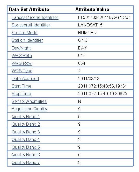
14 Click on Run to download the program. Once the application has been downloaded, you go back to your and click on the Entity ID (red oval). This will give you a screenshot of the scene and metadata about the scene. We will discuss the metadata in another tutorial. 72 P age
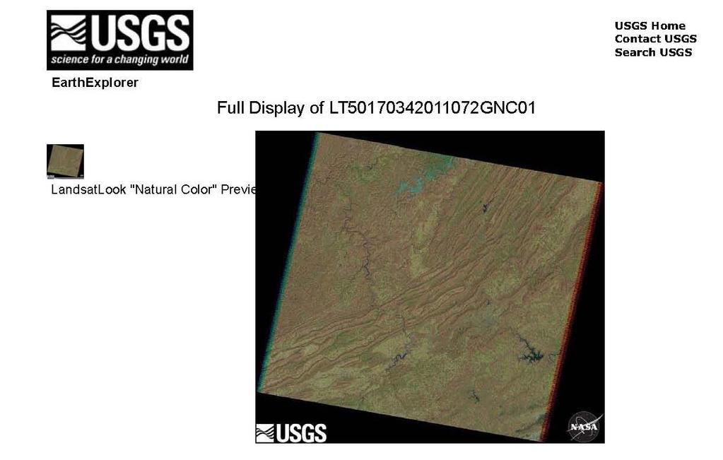
15 73 P age
. 74 P age")
16 Go to the bottom and click on Download (red oval). 74 P age
, but if you want images upon which you can conduct")

17 You will see the following screen. You can just access the jpegs (the first 3 items in the list), but if you want images upon which you can conduct analyses, you need the Level 1 Product (155MB Geotiff). Geotiffs are images upon which you can perform analyses. Click on Download next to the Level 1 Product. You get the download window. Save it and wait. This is a very large file and will take a few minutes or more (depending on your WiFi speed) to save. 75 Page

18 Once it has finished downloading, right click on the file and click on Open Containing Folder. This will take you to the area on your computer where the file downloaded. Right click on the file name and click on Extract, getting the following window. Clicking on this button will allow you to navigate to the folder where you want to save the file. Once the file has been extracted (unzipped), navigate to the folder where you unzipped it. You will find a.tar file. This is another zipped file. (Note - because of the file size, these are double zipped, so you have to unzip them twice). Right click and unzip (extract to here) again. Once it is finished, you will have the following files in your folder: 76 P age

19 You have successfully downloaded the Landsat scene that includes Roanoke, Virginia dated March 13, We will discuss the files in the tutorials on Information about your Downloaded Landsat Imagery and Band Combinations. You will need to determine if your downloaded imagery needs further processing beyond that completed by the USGS. For more information about the level and type of USGS processing of Landsat scenes, go to See also Masek, J.G., et al., A Landsat surface reflectance data set for North America, Geoscience and Remote Sensing Letters, : p This exercise, in combination with the companion GloVIS tutorial prepares you with the skills to download Landsat imagery. Subsequent tutorials will introduce techniques to analyze this imagery to extract information to support your research objectives. 77 P age
20 Notes: 78 P age
Remote Sensing in an
 Chapter 11: Creating a Composite Image from Landsat Imagery Remote Sensing in an ArcMap Environment Remote Sensing Analysis in an ArcMap Environment Tammy E. Parece Image source: landsat.usgs.gov Tammy
Remote Sensing in an
 Chapter 6: Displaying Data Remote Sensing in an ArcMap Environment Remote Sensing Analysis in an ArcMap Environment Tammy E. Parece Image source: landsat.usgs.gov Tammy Parece James Campbell John McGee
Remote Sensing in an
 Chapter 15: Spatial Enhancement of Landsat Imagery Remote Sensing in an ArcMap Environment Remote Sensing Analysis in an ArcMap Environment Tammy E. Parece Image source: landsat.usgs.gov Tammy Parece James
Remote Sensing in an
 Chapter 20: Accuracy Assessment Remote Sensing in an ArcMap Environment Remote Sensing Analysis in an ArcMap Environment Tammy E. Parece Image source: landsat.usgs.gov Tammy Parece James Campbell John
Downloading Imagery & LIDAR
 Downloading Imagery & LIDAR 333 Earth Explorer The USGS is a great source for downloading many different GIS data products for the entire US and Canada and much of the world. Below are instructions for
Downloading and formatting remote sensing imagery using GLOVIS
 Downloading and formatting remote sensing imagery using GLOVIS Students will become familiarized with the characteristics of LandSat, Aerial Photos, and ASTER medium resolution imagery through the USGS
Help Guide for creating a. Hofstra Continuing Education - Saturday Classes for Young People - Summer Camps
 Help Guide for creating a Hofstra Continuing Education - Saturday Classes for Young People - Summer Camps Student Portal Account & Register for classes/summer camp & Make Additional Payments to your account
Lesson 3: Working with Landsat Data
 Lesson 3: Working with Landsat Data Lesson Description The Landsat Program is the longest-running and most extensive collection of satellite imagery for Earth. These datasets are global in scale, continuously
Please show the instructor your downloaded index files and orthoimages.
 Student Exercise 1: Sandia Forest Infestation Acquiring Orthophotos and Satellite Imagery Please show the instructor your downloaded index files and orthoimages. Objectives: Determine appropriate imagery
White paper brief IdahoView Imagery Services: LISA 1 Technical Report no. 2 Setup and Use Tutorial
 White paper brief IdahoView Imagery Services: LISA 1 Technical Report no. 2 Setup and Use Tutorial Keith T. Weber, GISP, GIS Director, Idaho State University, 921 S. 8th Ave., stop 8104, Pocatello, ID
The (False) Color World
 Color World") There s more to the world than meets the eye In this activity, your group will explore: The Value of False Color Images Different Types of Color Images The Use of Contextual Clues for Feature Identification
There s more to the world than meets the eye In this activity, your group will explore: The Value of False Color Images Different Types of Color Images The Use of Contextual Clues for Feature Identification
Visualizing a Pixel. Simulate a Sensor s View from Space. In this activity, you will:
 Simulate a Sensor s View from Space In this activity, you will: Measure and mark pixel boundaries Learn about spatial resolution, pixels, and satellite imagery Classify land cover types Gain exposure to
Morphology Change Procedure using Satellite Derived Bathymetry
 Morphology Change Procedure using Satellite Derived Bathymetry Brian Madore December 23, 2014 To monitor the morphology of a region it is important to have imagery which is taken consistently and can cover
How to download library ebooks to your Kindle
 How to download library ebooks to your Kindle You can download Kindle ebooks through the Ella Johnson Memorial Library. To check out and download books to your Kindle you will need to have: Your Ella Johnson
The first part of Module three, data and tools, presents some of the resources available on the internet to get images from the satellites presented
 The first part of Module three, data and tools, presents some of the resources available on the internet to get images from the satellites presented in the previous module and some uses of the images,
DocuSign Setup Admin. DocuSign User Setup Process Overview. Setting up a new DocuSign user
 DocuSign Setup Admin DocuSign User Setup Process Overview 1) CORE-CT Security receives request to set up new supplier contract document creator 2) CORE-CT security team sets up Roles for the User 3) DocuSign
Catholic Education Center, LLC User Manual. If you need further assistance, please
 1 Catholic Education Center, LLC User Manual If you need further assistance, please email: catholiceducationcenter@yahoo.com or, telephone: 703-785-2319 (M-F: 9-5) Getting Started. Using your internet
Copyright 2009 Aladdin Knowledge Systems Ltd. All rights reserved. All trade and service marks, logos and trade names(collectively, the "Marks")
") Copyright 2009 Aladdin Knowledge Systems Ltd. All rights reserved. All trade and service marks, logos and trade names(collectively, the "Marks") mentioned herein, whether registered or no, are proprietary
Copyright 2009 Aladdin Knowledge Systems Ltd. All rights reserved. All trade and service marks, logos and trade names(collectively, the "Marks") mentioned herein, whether registered or no, are proprietary
The preferred browser for using PaySchools is Google Chrome PaySchools is not compatible with Internet Explorer 11 and above!
 The PaySchools Central link for Chippewa Valley Schools can be found on the CVS website in the For Parents section. It is located on the right hand side within the gray banner. Click the link to go to
Landsat 8 Pansharpen and Mosaic Geomatica 2015 Tutorial
 Landsat 8 Pansharpen and Mosaic Geomatica 2015 Tutorial On February 11, 2013, Landsat 8 was launched adding to the constellation of Earth imaging satellites. It is the seventh satellite to reach orbit
Grant Boxer Consultant Geologist March 10th 2014 (Updated Nov 2014)
") Grant Boxer Consultant Geologist March 10th 2014 (Updated Nov 2014) Work flow for Landsat 8 Landgate Data Selecting and processing basic data Importing into MapInfo Applications SLIP Portal WMS access
Grant Boxer Consultant Geologist March 10th 2014 (Updated Nov 2014) Work flow for Landsat 8 Landgate Data Selecting and processing basic data Importing into MapInfo Applications SLIP Portal WMS access
WGISS-42 USGS Agency Report
 WGISS-42 USGS Agency Report U.S. Department of the Interior U.S. Geological Survey Kristi Kline USGS EROS Center Major Activities Landsat Archive/Distribution Changes Land Change Monitoring, Assessment,
29 th Annual Louisiana RS/GIS Workshop April 23, 2013 Cajundome Convention Center Lafayette, Louisiana
 Landsat Data Continuity Mission 29 th Annual Louisiana RS/GIS Workshop April 23, 2013 Cajundome Convention Center Lafayette, Louisiana http://landsat.usgs.gov/index.php# Landsat 5 Sets Guinness World Record
A step-by-step process for attaching a photo of the park through Android Mobile Application
 A step-by-step process for attaching a photo of the park through Android Mobile Application Feedback is registered by the customer with the details of the customer and park through web based enabled application
How Do I Register for a CA Fire and Rescue Training Course
 This lesson will show you how to use our registration software. 1) Make sure you are on our registration site at: https://fireandrescuetraining.gosignmeup.com 2) The first thing you will want to do is
How to Access Imagery and Carry Out Remote Sensing Analysis Using Landsat Data in a Browser
 How to Access Imagery and Carry Out Remote Sensing Analysis Using Landsat Data in a Browser Including Introduction to Remote Sensing Concepts Based on: igett Remote Sensing Concept Modules and GeoTech
Accessing e-books with your e-reader
 e-reader 1 Accessing e-books with your e-reader What you need to know about library e-books is that each one is protected by Digital Rights Management (DRM). This means that access to e-books is restricted
DWG Register User Guide October Adding Drawings... 2 Statuses... 2 Archive... 4 Change Requests... 5 Transmittals... 5 Admin...
 Contents Adding Drawings... 2 Statuses... 2 Archive... 4 Change Requests... 5 Transmittals... 5 Admin... 6 https://dwgregister.com Page 1 Crypto Pit Pty Ltd Adding Drawings You can upload any type of electronic
Scheduling SmarterProctoring Exams
 Scheduling SmarterProctoring Exams Hello and welcome to FSCJ s Distance Learning! You are taking a class that requires proctored testing, so we have prepared a series of short tutorials designed to instruct
Using Soil Productivity to Assess Agricultural Land Values in North Dakota
 Using Soil Productivity to Assess Agricultural Land Values in North Dakota STUDENT HANDOUT Overview Why is assigning a true and full value to agricultural land parcels important? Agricultural production
Library ebooks and Your Kindle
 Library ebooks and Your Kindle Library ebooks now can be read on your Kindle. You need a computer with an Internet connection, and a valid library card. When using your Kindle for the first time, you will
Land Cover Change Analysis An Introduction to Land Cover Change Analysis using the Multispectral Image Data Analysis System (MultiSpec )
") Land Cover Change Analysis An Introduction to Land Cover Change Analysis using the Multispectral Image Data Analysis System (MultiSpec ) Level: Grades 9 to 12 Windows version With Teacher Notes Earth Observation
Land Cover Change Analysis An Introduction to Land Cover Change Analysis using the Multispectral Image Data Analysis System (MultiSpec ) Level: Grades 9 to 12 Windows version With Teacher Notes Earth Observation
How To Handbook For Learners
 How To Handbook For Learners 2017 Contents 3 How do I log in? 4-5 How do I watch a video? 6-9 How do I take an assessment? 10-11 How do I review an assessment I have just written? 12-13 How do I review
Supervised Land Cover Classification An introduction to digital image classification using the Multispectral Image Data Analysis System (MultiSpec )
") Supervised Land Cover Classification An introduction to digital image classification using the Multispectral Image Data Analysis System (MultiSpec ) Level: Grades 9 to 12 Windows version With Teacher Notes
Supervised Land Cover Classification An introduction to digital image classification using the Multispectral Image Data Analysis System (MultiSpec ) Level: Grades 9 to 12 Windows version With Teacher Notes
Step By Step Instructions for Registering Students Online In Skyward
 Step By Step Instructions for Registering Students Online In Skyward This guide will help you to register your students online in Skyward, Tri-Creek School Corporation s new student management system.
Laboratory Exercise 1
 Page 1 Laboratory Exercise 1 GEOG*2420 The Earth From Space University of Guelph, Department of Geography Prof. John Lindsay Fall 2013 Total of 32 marks Learning objectives The intention of this lab exercise
2018 Student s Guide.
 2018 Student s Guide www.scienteer.com Student Guide Page 1 Student Guide Table of Contents Registration... 3 Returning Students (students who had a Scienteer account last year)... 3 Logging in for the
Reviewing Your Tax Return In Your Portal
 Reviewing Your Tax Return In Your Portal 1. Go to our website www.franklinincpa.com and click on the link at the bottom left of the screen for Client Connect. a. This link will take you to the login screen
Author Tutorial for OPTE Editorial Manager System
 CONTENTS Registration/Login/Password... 2 Edit Account Information... 5 Track Manuscript Status... 15 Submit Revised Manuscript... 16 View Manuscript Decision... 21 Registration/Login/Password In order
Harrison Allen s Online Tutor Management System. Online Tutor System Help Sheet
 Harrison Allen s Online Tutor Management System Online Tutor System Help Sheet The Harrison Allen Online Tutor Management System This guide is intended to help you get up and running quickly and easily.
Part 1. Tracing the Dimensions of Some Common Pixel Sizes using a GPS Receiver
 Field and Laboratory Exercise PIXEL DELINEATIONS 1 IMPORTING GPS DATA TO IMAGE BACKGROUND Objectives: 1. Demonstrate the differences in spatial resolution of selected remote sensing instruments. 2. Use
Registering for Corban Accelerated Online
 Registering for Corban Accelerated Online These are the steps you are about to complete: Login to SIS Search for your course(s) Select the course(s) Add to your schedule Pay for your course(s)* You re
Lesson 9: Multitemporal Analysis
 Lesson 9: Multitemporal Analysis Lesson Description Multitemporal change analyses require the identification of features and measurement of their change through time. In this lesson, we will examine vegetation
Getting Started with Ride Connection Learning Center
 Purpose: This document details how to access the Ride Connection Learning Center. Once you have accessed the center you can: Create a new user account Select online trainings to participate in Complete
Land Cover Change Analysis An Introduction to Land Cover Change Analysis using the Multispectral Image Data Analysis System (MultiSpec )
") Land Cover Change Analysis An Introduction to Land Cover Change Analysis using the Multispectral Image Data Analysis System (MultiSpec ) Level: Grades 9 to 12 Macintosh version Earth Observation Day Tutorial
Land Cover Change Analysis An Introduction to Land Cover Change Analysis using the Multispectral Image Data Analysis System (MultiSpec ) Level: Grades 9 to 12 Macintosh version Earth Observation Day Tutorial
Lab 3: Image Acquisition and Geometric Correction
 Geography 309 Lab 3 Answer Page 1 Objectives Preparation Lab 3: Image Acquisition and Geometric Correction Due Date: October 22 to introduce you to digital imagery and how it can be displayed and manipulated
Step 1. - To Create an Account
 Kuskitannee Lodge 168 Website registration walk through Overview In order to make it easier to plan for weekends and to allow users to easily register online a process has been created which will allow
Click the Online Bookstore Icon
 Go to my.tfc.edu Once here, you will put in your TFC user name and password. You should have received an email including your TFC login credentials. If you don t have this, email bschenck@tfc.edu to get
You should see the following screen when you first login to Student E-Service
 You should see the following screen when you first login to Student E-Service Check your status at the top of the screen. It should read Ready to Register Online You will find useful information in the
The Phi Beta Kappa Society. Registration Procedures: Instructions for Students
 The Phi Beta Kappa Society Member Registration Procedures for Students March 10, 2015 Congratulations on your invitation to join Phi Beta Kappa, the nation s oldest and most prestigious academic honor
Global Land Survey Activities and Land Cover Analysis from Landsat
 Global Land Survey Activities and Land Cover Analysis from Landsat Shannon Franks, SGT/NASA Jeffrey G. Masek, NASA GSFC Garik Gutman, NASA HQ Rachel Headley, USGS CODATA, October 25, 2010 Background the
You should see the following screen when you first login to Student E-Service
 You should see the following screen when you first login to Student E-Service Check your status at the top of the screen. It should read Ready to Register Online You will find useful information in the
The Landsat Legacy: Monitoring a Changing Earth. U.S. Department of the Interior U.S. Geological Survey
 The Landsat Legacy: Monitoring a Changing Earth U.S. Department of the Interior U.S. Geological Survey Tom Loveland March 17, 2001 Landsat Science Mission Change is occurring at rates unprecedented in
Update on Landsat Program and Landsat Data Continuity Mission
 Update on Landsat Program and Landsat Data Continuity Mission Dr. Jeffrey Masek LDCM Deputy Project Scientist NASA GSFC, Code 923 November 21, 2002 Draft LDCM Implementation Phase RFP Overview Page 1 Celebrate!
Please note that you will not lose your initial placeholder allocation until you reach the final step (payment) of the change seats process!
 of the change seats process!") CHANGE SEATS NOT AVAILABLE ON MOBILE OR TABLET! If you would like to try to change your placeholder allocation, follow these steps. You must wait until your Seat Secure window is open before you can proceed.
CHANGE SEATS NOT AVAILABLE ON MOBILE OR TABLET! If you would like to try to change your placeholder allocation, follow these steps. You must wait until your Seat Secure window is open before you can proceed.
PRINTING ON YOUR IPAD
 PRINTING ON YOUR IPAD TABLE OF CONTENTS I don t have Papercut on my ipad... 1 I can t see any printers when trying to print... 2 The Papercut app wants me to sign in... 3 Can I print double sided?... 4
Copyright 2011 by Publish It! Online All rights reserved. Published by Family Literacy Press MSVU, Halifax, Nova Scotia.
 1 Copyright 2011 by Publish It! Online All rights reserved. Published by Family Literacy Press MSVU, Halifax, Nova Scotia. No part of this publication can be reproduced in any form without written permission
Frequently Asked Questions (FAQ s)
") Frequently Asked Questions (FAQ s) We hope you ll find all the information you need below, but if you have a query that s not covered here, please don t hesitate to get in touch with us. For account and
Frequently Asked Questions (FAQ s) We hope you ll find all the information you need below, but if you have a query that s not covered here, please don t hesitate to get in touch with us. For account and
MCLA Sample eportfolio Submission Instructions Bucket Time
 Bucket Time These instructions will help you submit your portfolio pages to our assessment system, also known as our BUCKETS. 1 Contents Log In... 3 Understanding Your eportfolio Homepage... 4 Selecting
A Step by Step guide to making and maintaining a Universal Credit claim online
 A Step by Step guide to making and maintaining a Universal Credit claim online welfare changes Before you make a Universal Credit Claim To make a Universal Credit claim, you will need: Email address Your
Submitting your Thesis or Project to ScholarWorks: Step- by- step instructions.
 1 Submitting your Thesis or Project to ScholarWorks: Step- by- step instructions. If you are planning to graduate this semester, you may be required to submit your thesis or graduate project to ScholarWorks.
LAND SURFACE TEMPERATURE MONITORING THROUGH GIS TECHNOLOGY USING SATELLITE LANDSAT IMAGES
 Abstract LAND SURFACE TEMPERATURE MONITORING THROUGH GIS TECHNOLOGY USING SATELLITE LANDSAT IMAGES Aurelian Stelian HILA, Zoltán FERENCZ, Sorin Mihai CIMPEANU University of Agronomic Sciences and Veterinary
How to Port your Number
 How to Port your Number A How To Guide on keeping your old number with nettalk Getting started with a new phone number is tough. You have to call everyone back and give them your new number, especially
Over 70 merit badge and High Adventure programs!
 Over 70 merit badge and High Adventure programs! We have our MB Class Registration system with a company called Tentaroo. There are a few little tricks so we thought it may be helpful if we put together
Submittal Exchange Design Team User Guide
 Submittal Exchange Design Team User Guide Version 17 November 2017 Contents About This Guide... 9 Access/Permissions... 11 What is Submittal Exchange for Design?... 11 How Can I Get Submittal Exchange
DEVELOPING THE WORKFORCE
 DEVELOPING THE WORKFORCE Assessing the quality of death certification: Instructions for the online assessment tool Resources and Tools 3 November 2016 About this series Capacity-building resources and
Closing Market Complete Closing Enterprise RamQuest. Integration User Guide
 Closing Market Complete Closing Enterprise RamQuest Integration User Guide Contact Us For customer assistance with The Fund integration contact The Funds Help Desk at 800.421.9378 or email HelpDesk@thefund.com
Guide for Converting Your Deposit to Broadway Season Seats
 Guide for Converting Your Deposit to Broadway Season Seats 1. Sign in with the e-mail that you made your deposit(s) with. Forgot your password? That s OK! Just click forgot password to create a new one.
NAVIGATION INSTRUCTIONS ««STEP 1»» Go to and log in using your registered username and password. Note: If you are uncertain about
 JEWELER KIOSK USER GUIDE Jeweler Kiosk www.jewelerkiosk.com was specifically designed with your customer, the end consumer in mind. Stuller brings you an easy to use, fully interactive virtual selling
Live Agent for Support Supervisors
 Live Agent for Support Supervisors Salesforce, Winter 17 @salesforcedocs Last updated: December 12, 2016 Copyright 2000 2016 salesforce.com, inc. All rights reserved. Salesforce is a registered trademark
DIVISION 1 GENERAL REQUIREMENTS SECTION SUBMITTAL PROCEDURES
 DIVISION 1 GENERAL REQUIREMENTS SECTION 01 33 00 PART 1 - GENERAL 1.1 SUMMARY A. This section includes administrative and procedural requirements for submittals required for performance of the work, including
GEOG432: Remote sensing Lab 3 Unsupervised classification
 GEOG432: Remote sensing Lab 3 Unsupervised classification Goal: This lab involves identifying land cover types by using agorithms to identify pixels with similar Digital Numbers (DN) and spectral signatures
AmericaView EOD 2016 page 1 of 16
 Remote Sensing Flood Analysis Lesson Using MultiSpec Online By Larry Biehl Systems Manager, Purdue Terrestrial Observatory (biehl@purdue.edu) v Objective The objective of these exercises is to analyze
Browser Streaming and Mobile-App Instructions for ios and Android tm
 Browser Streaming and Mobile-App Instructions for ios and Android tm February 07 Browser and Mobile-Device Instructions Browser Instructions... Access Comics Plus: Library Edition Through Your Browser
e-submission Quick Reference Guide for Economic Operators
 e-submission Quick Reference Guide for Economic Operators e-submission Quick Guide for Economic Operators Page 1 Welcome to e-submission. This quick reference guide contains: Introduction to e-submission
PUNE MUNICIPAL CORPORATION
 Help Manual of Single Window NOC Clearance For PMC Architect Console PUNE MUNICIPAL CORPORATION Table of Contents 1. Introduction... 3 2. Architect Help -step by step... 3 2.1 Link from PMC Website...
Using Nebraska OverDrive with an Amazon Kindle Device
 Using Nebraska OverDrive with an Amazon Kindle Device 1. Go to Nebraska OverDrive at http://nebraska.lib.overdrive.com 2. Use Advanced Search to find Kindle ebooks that are available. 3. Add an available
Field Device Manager Express
 Honeywell Process Solutions Field Device Manager Express Software Installation User's Guide EP-FDM-02430X R430 June 2012 Release 430 Honeywell Notices and Trademarks Copyright 2010 by Honeywell International
DocuSign Producer Training Guide Updated April 5, 2017
 DocuSign Producer Training Guide Updated April 5, 2017 Blue Cross and Blue Shield of Illinois, Blue Cross and Blue Shield of Montana, Blue Cross and Blue Shield of New Mexico, Blue Cross and Blue Shield
How to Register for Sports Clubs
 CSUF Sports Clubs Do Sports Easy (DSE) How-To What is Do Sports Easy (DSE)? DSE is software designed to aid in the management of Sports Clubs teams at Cal State Fullerton. DSE facilitates the registration
Owner User Guide Paying an Invoice
 Owner User Guide Paying an Invoice August 2017 v.1 1 Contents 1. Invoice Enquiry... 3 2. Printing Your Invoice... 7 3. Paying Your Invoice... 8 2 1. Invoice Enquiry Log on to www2.racingadmin.co.uk with
IE11, Edge (current version), Chrome (current version), Firefox (current version)
, Chrome (current version), Firefox (current version)") Quick Start Guide DocuSign for SharePoint Online v3.4 Published: October 13, 2017 Overview DocuSign for SharePoint Online allows users to sign or send documents for signature from a SharePoint Online library.
Quick Start Guide DocuSign for SharePoint Online v3.4 Published: October 13, 2017 Overview DocuSign for SharePoint Online allows users to sign or send documents for signature from a SharePoint Online library.
GRAPHOGAME User Guide:
 GRAPHOGAME User Guide: 1. User registration 2. Downloading the game using Internet Explorer browser or similar 3. Adding players and access rights to the games 3.1. adding a new player using the Graphogame
Welcome to 6 Trait Power Write!
 Welcome to 6 Trait Power Write! Student Help File Table of Contents Home...2 My Writing...3 Assignment Details...4 Choose a Topic...5 Evaluate Your Topic...6 Prewrite and Organize...7 Write Sloppy Copy...8
Navigating our Job Board is quick and easy!
 Navigating our Job Board is quick and easy! We hope these instructions will help you navigate our job board so you can apply for shops and start earning money! New to Pinnacle? If you re not yet signed
NORMALIZING ASTER DATA USING MODIS PRODUCTS FOR LAND COVER CLASSIFICATION
 NORMALIZING ASTER DATA USING MODIS PRODUCTS FOR LAND COVER CLASSIFICATION F. Gao a, b, *, J. G. Masek a a Biospheric Sciences Branch, NASA Goddard Space Flight Center, Greenbelt, MD 20771, USA b Earth
Live Agent for Support Supervisors
 Live Agent for Support Supervisors Salesforce, Winter 18 @salesforcedocs Last updated: November 2, 2017 Copyright 2000 2017 salesforce.com, inc. All rights reserved. Salesforce is a registered trademark
Using Web-based Tools for GIS-Friendly Satellite Imagery
 Using Web-based Tools for GIS-Friendly Satellite Imagery Lindsey Harriman SGT, Contractor to the USGS EROS Center, Sioux Falls, South Dakota **Work performed under USGS contract G10PC00044 U.S. Department
Sign Language Accessible Interpreters, LLC. ersp INSTRUCTIONS
 ersp is the online system that we use to keep track of jobs and assignments. You will be given a username and a password to access ersp prior to your first assignment. Username: Password: You must use
PaperCut VCA Cash Acceptor Manual
 PaperCut VCA Cash Acceptor Manual Contents 1 Introduction... 2 2 How PaperCut interfaces with the VCA... 2 3 Setup Phase 1: Device/Hardware Setup... 3 3.1 Networking/Firewall Configuration... 3 3.2 IP
DocuSign for Sugar 7 v1.0. Overview. Quick Start Guide. Published December 5, 2013
 Quick Start Guide DocuSign for Sugar 7 v1.0 Published December 5, 2013 Overview This guide provides information on installing and signing documents with DocuSign for Sugar7. The Release Notes for DocuSign
406LINK GSG.Rev.A. Getting Started Guide
 406LINK GSG.Rev.A Getting Started Guide Getting Started with 406Link Congratulations on your new subscription to 406Link.com. Here are some basic instructions on how you can get started in as little as
Author Instructions FPIN Editorial Manager
 Author Instructions FPIN Editorial Manager Login Information: www.editorialmanager.com/fpin Your username and password will have been sent to you by the FPIN Project Manager. If you do not have it, please
GOSYSTEM TAX 2016 RS E-FILE GUIDE LAST UPDATED: DECEMBER 22, 2016 TAX.THOMSONREUTERS.COM
 GOSYSTEM TAX 2016 RS E-FILE GUIDE LAST UPDATED: DECEMBER 22, 2016 TAX.THOMSONREUTERS.COM Note: Please note that all screen images are valid as of December 22, 2016 and are subject to change at Thomson
Live Agent for Support Supervisors
 Live Agent for Support Supervisors Salesforce, Winter 19 @salesforcedocs Last updated: November 1, 2018 Copyright 2000 2018 salesforce.com, inc. All rights reserved. Salesforce is a registered trademark
Mission Connect: Ministry Financials Getting Started
 Mission Connect: Ministry Financials Getting Started Accessing the Web Site 1. Go to the following web page: https://www.memphis-umc.net/treasurersoffice 2. Click on the link that says Tithing and Clergy
Basic Hyperspectral Analysis Tutorial
 Basic Hyperspectral Analysis Tutorial This tutorial introduces you to visualization and interactive analysis tools for working with hyperspectral data. In this tutorial, you will: Analyze spectral profiles
<Insert Picture Here> Using ERPi for EBS/FDM Data Loads into HFM
 Using ERPi for EBS/FDM Data Loads into HFM Wayne Paffhausen Senior Technical Support Engineer Program Agenda Create a Link inside of ERPi to the HFM Application Create an Import Format
2. Now you need to create permissions for all of your reviewers. You need to be in the Administration Tab to do so. Your screen should look like this:
 How to set up AppReview 1. Log in to AppReview at https://ar.applyyourself.com a. Use 951 as the school code, your 6+2 as your username, and the password you created. 2. Now you need to create permissions
Technician TRAINING WORKBOOK
 Technician TRAINING WORKBOOK XSELLERATOR Service Terminology Definitions... 2 Clocking Into-Out of XSELLERATOR Technician... 4 Logging On and Off a Work Order... 4 Recording Straight Time... 6 Requesting