Imaging Using Microwaves
|
|
|
- Job Daniels
- 5 years ago
- Views:
Transcription


1 Imaging Using Microwaves Delivering Exceptional Service in the National Interest Data created by Interferometric Synthetic Aperture Radar Unclassified Unlimited Release Name/Org: _Judith A. Ruffner, _ Date: 1/15/16_ Guidance: Multiple Bryan L. Burns, WA5VAH Senior Engineer blburns@sandia.gov Sandia National Laboratories is a multi-program laboratory managed and operated by Sandia Corporation, a wholly owned subsidiary of Lockheed Martin Corporation, for the U.S. Department of Energy s National Nuclear Security Administration under contract DE-AC04-94AL Rio Napo, Ecuador

2 Outline Synthetic Aperture Radar (SAR) Overview Capital Building Washington, DC Example Images Example Applications Aircraft Customer Comment Summary References 1 ft resolution 2

3 Synthetic Aperture Radar Has Unique Characteristics RF or Microwave illumination All weather Day and Night Coherent imaging system Images are displayed in two dimensions Range, distance from the radar Azimuth, proportional to Doppler frequency Invented about


4 Transmitter SAR Is Based On The Same Principle as Other Radars Antenna/Gimbal SARs transmit pulses Transmit Receive and receive echoes The time delay of the echo is proportional to the distance to the reflecting object. Range resolution is inversely proportional to the bandwidth of the transmitted pulse. For example: 1 foot resolution requires ~ 500 MHz bandwidth. 4

5 synthetic aperture A Small Antenna Creates A Large Synthetic Aperture An Optical Analogy Direction of travel Large Lens Transmit a pulse and receive an echo from each antenna position. Imaged Scene 7 X 15 antenna Lines show direction of antenna pointing. Small Lens By coherently combining the information from a relatively small antenna at locations along a distance, we achieve finer resolution than a single, large antenna. Azimuth resolution is inversely proportional to synthetic aperture length. 5 Synthetic Aperture Radar (SAR)
 Processing took months Now processing is done on digital")

6 SAR Processing Originally done using optical techniques Lenses Prisms Film to capture imagery (poor dynamic range) Processing took months Now processing is done on digital computers Commercial and Custom Digital filtering Interpolations Fast Fourier Transforms Complex convolutions High dynamic range Custom Digital Receiver Custom Digital Waveform Synthesizer 6


7 National Guard Armory, NM 7 4-inch Resolution

8 Tijeras Arroyo Golf Course 8 4-inch Resolution

9 Finer Resolution Improves Ability to Recognize Objects 4-inch resolution 6-inch resolution 1-foot resolution 9

10 DC3 and Helicopter Static Display - KAFB 4-inch Resolution


11 HELICOPTER ON RAMP 4-inch Resolution, Ka-Band 11

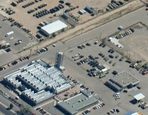
12 Aircraft On Ramp - Albuquerque 12 4-inch Resolution, Ka-Band

13 4 Fine Resolution Strip Map Single Pass, Contiguous Sandia First (Sep 2005): Contiguous 4 stripmap Made from three consecutive apertures collected on a single pass A stripmap of ~ pixels Range ~ 3300 meters, Grazing angle ~ 30 degrees Swath ~ 300 meters Range curvature is corrected (roads are straight) 13

14 Albuquerque, NM N Academy Menaul Tramway I-40 I inch resolution
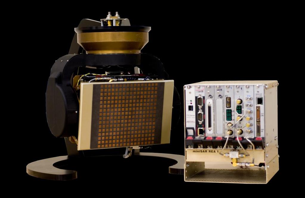


15 Example Applications Single-Slot Custom or COTS Power Supply Custom DRX Custom QDWS Radar Control Processor (Gespac PCIPPC-2) 15 Image Formation Processor (Motorola/Force PPMC- 280) Motion Measurement Processor (Radstone EPMCQ2) minisar radar Custom LTCC RF (up/dnconverter)

16 16 NYANG LC130 Stuck in Crevasse


17 Tres Hermanas Crevasses LC130

18 18 1ft resolution SAR Image of McMurdo Station


19 Exploitation of SAR Imagery Getting information from the imagery 19 C130 and V22 - KAFB Power Substation


20 Coherent Change Detection Senses Millimeter-Level Changes Reference image taken earlier Current image Coherent Change Detection Magnitude Change Detection 20

21 Image 1 RMabry_NS_1-TO-FL_6500_001\Data\M F1C5\Disturbance\Patch003 Image 1: Created: 4/1/2009 9:47:13 AM (local) //mdet.exe/&fp=dsm f1.xml&c=5&rs=rmabry_ns_1-to-fl_6500_001&z=6.674&ll= , &p=ncp Image 2: Created: 4/1/ :04:35 AM (local) Image 3: Created: 4/1/ :12:48 AM (local)
")
22 Image 2 Image 1: Created: 4/1/2009 9:47:13 AM (local) Image 2: Created: 4/1/ :04:35 AM (local) Image 3: Created: 4/1/ :12:48 AM (local) RMabry_NS_1-TO-FL_6500_001\Data\M F1C5\Disturbance\Patch003
 Image")
23 CCD12 Image 1: Created: 4/1/2009 9:47:13 AM (local) Image 2: Created: 4/1/ :04:35 AM (local) Image 3: Created: 4/1/ :12:48 AM (local) RMabry_NS_1-TO-FL_6500_001\Data\M F1C5\Disturbance\Patch003
 Image")
24 Image 3 Image 1: Created: 4/1/2009 9:47:13 AM (local) Image 2: Created: 4/1/ :04:35 AM (local) Image 3: Created: 4/1/ :12:48 AM (local) RMabry_NS_1-TO-FL_6500_001\Data\M F1C5\Disturbance\Patch003
25 CCD13 Image 1: Created: 4/1/2009 9:47:13 AM (local) Image 2: Created: 4/1/ :04:35 AM (local) Image 3: Created: 4/1/ :12:48 AM (local) RMabry_NS_1-TO-FL_6500_001\Data\M F1C5\Disturbance\Patch003

26 Terrain Elevation Measurement Academy I-25 N Tramway 2002 Terrain Elevation Albuquerque, NM I-40


27 SAR Data Dramatically Improved Terrain Elevation Data in Ecuador Rendering from NIMA Data Large areas in Northern Ecuador only data of this quality. Rendering from Radar Data


28 A Comparison of Radar Data and Photograph of Coca, Ecuador 28 Page 28:dlb:04Sep2002


29 United States RTV Geological IFSAR Survey 30 3 Meter Terrain Park City, Utah 29 For Additional Information Contact Director JPSD at (703)


30 Video SAR Wyoming Gate KAFB M-47 Tanks KAFB

31 Eubank Gate Kirtland Air 31 Force Base

32 Aircraft Washington, DC

33 Army/Air Force Rockwell Collins Army Navy General Atomics Navy Air Force / Industry Partner Navy / Raytheon 33
 Real-time digital terrain Ground Moving")


34 Utilization of This Technology Requires System Level Thinking Radar Modes SAR (Spotlight, Stripmap, Circle, Tracking) Real-time digital terrain Ground Moving Target Indication System Design Architectures Concept of Operations Solving Customer Problems Algorithms Image Formation Autofocus Image exploitation Coherent Change Detection Moving target indication Hardware Advanced radar architectures Miniaturized hardware to reduce size, weight, and cost Advanced Radar Modes Video SAR Route Following Stripmap 34

35 Sandia Directly Supports the Warfighter Sandia, working with government partners, is providing technologies to the Warfighter which locate and help defeat improvised explosive devices (IEDs). These technologies are directly linked to saving the lives of many service men and women. Sandia s history of developing radars for Nuclear Weapons led to the development of advanced Synthetic Aperture Radars (SARs) that are today fielded on small unmanned aerial vehicles (UAVs) to locate and help defeat IEDs. This Counter IED system has been determined by the Department of Defense to significantly exceed all performance requirements and was unanimously recommended as a Proven Counter IED system. A Class III UAV outfitted with a Sandia developed SAR. Words from the Warfighter: That thing is amazing, I wish we had it from the beginning a lot of people would still be around right now.. I have witnessed 2 occasions in the passed few weeks where things could have turned out bad and you all saved the day. 35
36 Summary Imaging using microwaves can be done using Synthetic Aperture Radar (SAR). SAR radars have many similarities to other traditional radar systems. Images produced appear similar to other imaging techniques such as an optical camera; however, there are important differences Range dimension Azimuth dimension Many types of objects are easily identified in SAR imagery: roads, rivers, trees, natural vegetation,... Interpretation of some objects requires understanding of backscatter phenomenology: man-made objects such as vehicles, bridges, buildings, Exploitation of the SAR imagery has been frequently utilized for Terrain elevation measurement Change detection 36
37 37 References
38 References Sandia SAR web site Amateur built SAR 38
Synthetic Aperture Radar. Hugh Griffiths THALES/Royal Academy of Engineering Chair of RF Sensors University College London
 Synthetic Aperture Radar Hugh Griffiths THALES/Royal Academy of Engineering Chair of RF Sensors University College London CEOI Training Workshop Designing and Delivering and Instrument Concept 15 March
A High-Resolution, Four-Band SAR Testbed with Real-Time Image Formation
 A High-Resolution, Four-Band SAR Testbed with Real-Time Image Formation Bruce Walker, Grant Sander, Marty Thompson, Bryan Burns, Rick Fellerhoff, and Dale Dubbert Sandia National Laboratories, P. O. Box
...This paper is UNCLASSIFIED
 ...This paper is Approved for public release; distribution A High Resolution, Light-Weight, Synthetic Aperture Radar for UAV Application June 1999 W. H. Hensley, A. W. Doeny, B. C. Walker Sandia National
Synthetic Aperture Radar
 Synthetic Aperture Radar Picture 1: Radar silhouette of a ship, produced with the ISAR-Processor of the Ocean Master A Synthetic Aperture Radar (SAR), or SAR, is a coherent mostly airborne or spaceborne
Special Projects Office. Mr. Lee R. Moyer Special Projects Office. DARPATech September 2000
 Mr. Lee R. Moyer DARPATech 2000 6-8 September 2000 1 CC&D Tactics Pose A Challenge to U.S. Targeting Systems The Challenge: Camouflage, Concealment and Deception techniques include: Masking: Foliage cover,
BYU SAR: A LOW COST COMPACT SYNTHETIC APERTURE RADAR
 BYU SAR: A LOW COST COMPACT SYNTHETIC APERTURE RADAR David G. Long, Bryan Jarrett, David V. Arnold, Jorge Cano ABSTRACT Synthetic Aperture Radar (SAR) systems are typically very complex and expensive.
Signal Processing Architectures for Ultra-Wideband Wide-Angle Synthetic Aperture Radar Applications
 Signal Processing Architectures for Ultra-Wideband Wide-Angle Synthetic Aperture Radar Applications Atindra Mitra Joe Germann John Nehrbass AFRL/SNRR SKY Computers ASC/HPC High Performance Embedded Computing
The BYU microsar System
 The BYU microsar System David G. Long BYU Center for Remote Sensing, Microwave Earth Remote Sensing Laboratory Electrical and Computer Engineering Dept., Brigham Young University 459 Clyde Building, Provo,
Lecture 1 INTRODUCTION. Dr. Aamer Iqbal Bhatti. Radar Signal Processing 1. Dr. Aamer Iqbal Bhatti
 Lecture 1 INTRODUCTION 1 Radar Introduction. A brief history. Simplified Radar Block Diagram. Two basic Radar Types. Radar Wave Modulation. 2 RADAR The term radar is an acronym for the phrase RAdio Detection
UNCLASSIFIED. A High Resolution, Light-Weight, Synthetic Aperture Radar for UAV Application (U) June 1999
 June 1999") This paper is Approved for public release; distribution is unlimited. A High Resolution, Light-Weight, Synthetic Aperture Radar for UAV Application (U) June 1999 W. H. Hensley, A. W. Doerry, B. C. Walker
This paper is Approved for public release; distribution is unlimited. A High Resolution, Light-Weight, Synthetic Aperture Radar for UAV Application (U) June 1999 W. H. Hensley, A. W. Doerry, B. C. Walker
Active and Passive Microwave Remote Sensing
 Active and Passive Microwave Remote Sensing Passive remote sensing system record EMR that was reflected (e.g., blue, green, red, and near IR) or emitted (e.g., thermal IR) from the surface of the Earth.
Robust Wideband Waveforms for Synthetic Aperture Radar (SAR) and Ground Moving Target Indication (GMTI) Applications
 and Ground Moving Target Indication (GMTI) Applications") Robust Wideband Waveforms for Synthetic Aperture Radar (SAR) and Ground Moving Target Indication (GMTI) Applications DARPA SBIR Topic: SB82-2, Phase II Army Contract W31P4Q-11-C-43 Program Summary September
Robust Wideband Waveforms for Synthetic Aperture Radar (SAR) and Ground Moving Target Indication (GMTI) Applications DARPA SBIR Topic: SB82-2, Phase II Army Contract W31P4Q-11-C-43 Program Summary September
3. give specific seminars on topics related to assigned drill problems
 HIGH RESOLUTION AND IMAGING RADAR 1. Prerequisites Basic knowledge of radar principles. Good background in Mathematics and Physics. Basic knowledge of MATLAB programming. 2. Course format and dates The
SAR Image Post Processing and Exploitation. Post Image Formation Processing
 SAR Image Post Processing and Exploitation 1 This presentation is an informal communication intended for a limited audience comprised of attendees to the Institute for Computational and Experimental Research
Synthetic Aperture Radar (SAR) Imaging using Global Back Projection (GBP) Algorithm For Airborne Radar Systems
 Imaging using Global Back Projection (GBP) Algorithm For Airborne Radar Systems") Proc. of Int. Conf. on Current Trends in Eng., Science and Technology, ICCTEST Synthetic Aperture Radar (SAR) Imaging using Global Back Projection (GBP) Algorithm For Airborne Radar Systems Kavitha T M
Proc. of Int. Conf. on Current Trends in Eng., Science and Technology, ICCTEST Synthetic Aperture Radar (SAR) Imaging using Global Back Projection (GBP) Algorithm For Airborne Radar Systems Kavitha T M
Active and Passive Microwave Remote Sensing
 Active and Passive Microwave Remote Sensing Passive remote sensing system record EMR that was reflected (e.g., blue, green, red, and near IR) or emitted (e.g., thermal IR) from the surface of the Earth.
Introduction to Imaging Radar INF-GEO 4310
 Introduction to Imaging Radar INF-GEO 4310 22.9.2011 Literature Contact: yoann.paichard@ffi.no Suggested readings: Fundamentals of Radar Signal Processing, M.A. Richards, McGraw-Hill, 2005 High Resolution
Real-Time Through-Wall Imaging Using an Ultrawideband Multiple-Input Multiple-Output (MIMO) Phased-Array Radar System
 Phased-Array Radar System") Real-Time Through-Wall Imaging Using an Ultrawideband Multiple-Input Multiple-Output (MIMO) Phased-Array Radar System G. L. Charvat, T. S. Ralston, and J. E. Peabody Aerospace Sensor Technology Group This
Real-Time Through-Wall Imaging Using an Ultrawideband Multiple-Input Multiple-Output (MIMO) Phased-Array Radar System G. L. Charvat, T. S. Ralston, and J. E. Peabody Aerospace Sensor Technology Group This
UNCLASSIFIED. UNCLASSIFIED R-1 Line Item #13 Page 1 of 11
 Exhibit R-2, PB 2010 Air Force RDT&E Budget Item Justification DATE: May 2009 Applied Research COST ($ in Millions) FY 2008 Actual FY 2009 FY 2010 FY 2011 FY 2012 FY 2013 FY 2014 FY 2015 Cost To Complete
Remote Sensing. Ch. 3 Microwaves (Part 1 of 2)
") Remote Sensing Ch. 3 Microwaves (Part 1 of 2) 3.1 Introduction 3.2 Radar Basics 3.3 Viewing Geometry and Spatial Resolution 3.4 Radar Image Distortions 3.1 Introduction Microwave (1cm to 1m in wavelength)
Remote Sensing Ch. 3 Microwaves (Part 1 of 2) 3.1 Introduction 3.2 Radar Basics 3.3 Viewing Geometry and Spatial Resolution 3.4 Radar Image Distortions 3.1 Introduction Microwave (1cm to 1m in wavelength)
Introduction Active microwave Radar
 RADAR Imaging Introduction 2 Introduction Active microwave Radar Passive remote sensing systems record electromagnetic energy that was reflected or emitted from the surface of the Earth. There are also
Acknowledgment. Process of Atmospheric Radiation. Atmospheric Transmittance. Microwaves used by Radar GMAT Principles of Remote Sensing
 GMAT 9600 Principles of Remote Sensing Week 4 Radar Background & Surface Interactions Acknowledgment Mike Chang Natural Resources Canada Process of Atmospheric Radiation Dr. Linlin Ge and Prof Bruce Forster
Synthetic Aperture Radar (SAR) images features clustering using Fuzzy c- means (FCM) clustering algorithm
 images features clustering using Fuzzy c- means (FCM) clustering algorithm") Article Synthetic Aperture Radar (SAR) images features clustering using Fuzzy c- means (FCM) clustering algorithm Rashid Hussain Faculty of Engineering Science and Technology, Hamdard University, Karachi
Article Synthetic Aperture Radar (SAR) images features clustering using Fuzzy c- means (FCM) clustering algorithm Rashid Hussain Faculty of Engineering Science and Technology, Hamdard University, Karachi
Lensless Synthetic Aperture Chirped Amplitude-Modulated Laser Radar for Microsystems
 Lensless Synthetic Aperture Chirped Amplitude-Modulated Laser Radar for Microsystems by Barry Stann and Pey-Schuan Jian ARL-TN-308 April 2008 Approved for public release; distribution is unlimited. NOTICES
History of Velocimetry Technology
 SAND2012-9001C? History of Velocimetry Technology Brook Jilek Explosives Technologies Group Sandia National Laboratories Albuquerque, NM bajilek@sandia.gov The 7th Annual PDV Workshop, Albuquerque, NM
Signal Processing Architectures for Ultra-Wideband Wide-Angle Synthetic Aperture Radar Applications
 Signal Processing Architectures for Ultra-Wideband Wide-Angle Synthetic Aperture Radar Applications Atindra Mitra Joe Germann John Nehrbass AFRL/SNRR SKY Computers ASC/HPC High Performance Embedded Computing
RADAR DEVELOPMENT BASIC CONCEPT OF RADAR WAS DEMONSTRATED BY HEINRICH. HERTZ VERIFIED THE MAXWELL RADAR.
 1 RADAR WHAT IS RADAR? RADAR (RADIO DETECTION AND RANGING) IS A WAY TO DETECT AND STUDY FAR OFF TARGETS BY TRANSMITTING A RADIO PULSE IN THE DIRECTION OF THE TARGET AND OBSERVING THE REFLECTION OF THE
10 Radar Imaging Radar Imaging
 10 Radar Imaging Active sensors provide their own source of energy to illuminate the target. Active sensors are generally divided into two distinct categories: imaging and non-imaging. The most common
Proceedings of the ASME th International Conference on Ocean, Offshore and Arctic Engineering OMAE2017 June 25-30, 2017, Trondheim, Norway
 Proceedings of the ASME 2017 36th International Conference on Ocean, Offshore and Arctic Engineering OMAE2017 June 25-30, 2017, Trondheim, Norway OMAE2017-61264 A UAV SAR PROTOTYPE FOR MARINE AND ARCTIC
Robust Wideband Waveforms for Synthetic Aperture Radar (SAR) and Ground Moving Target Indication (GMTI) Applications
 and Ground Moving Target Indication (GMTI) Applications") Robust Wideband Waveforms for Synthetic Aperture Radar (SAR) and Ground Moving Target Indication (GMTI) Applications DARPA SBIR Topic: SB82-2, Phase II Army Contract W31P4Q-11-C-43 Program Summary September
Robust Wideband Waveforms for Synthetic Aperture Radar (SAR) and Ground Moving Target Indication (GMTI) Applications DARPA SBIR Topic: SB82-2, Phase II Army Contract W31P4Q-11-C-43 Program Summary September
RCS Measurements of a PT40 Remote Control Plane at Ka-Band
 RCS Measurements of a PT40 Remote Control Plane at Ka-Band by Thomas J. Pizzillo ARL-TN-238 March 2005 Approved for public release; distribution unlimited. NOTICES Disclaimers The findings in this report
GEO 428: DEMs from GPS, Imagery, & Lidar Tuesday, September 11
 GEO 428: DEMs from GPS, Imagery, & Lidar Tuesday, September 11 Global Positioning Systems GPS is a technology that provides Location coordinates Elevation For any location with a decent view of the sky
Principles of Pulse-Doppler Radar p. 1 Types of Doppler Radar p. 1 Definitions p. 5 Doppler Shift p. 5 Translation to Zero Intermediate Frequency p.
 Preface p. xv Principles of Pulse-Doppler Radar p. 1 Types of Doppler Radar p. 1 Definitions p. 5 Doppler Shift p. 5 Translation to Zero Intermediate Frequency p. 6 Doppler Ambiguities and Blind Speeds
ATA s Nanoradian-Class Rotational Sensors. 10 November 2009
 ATA s Nanoradian-Class Rotational Sensors 10 November 2009 ATA Overview Founded 1975 A-TECH Corporation, d.b.a. Applied Technology Associates Customers Include USAF, Sandia NL, US Army, MDA, NASA, US Navy,
VHF/UHF Imagery of Targets, Decoys, and Trees
 F/UHF Imagery of Targets, Decoys, and Trees A. J. Gatesman, C. Beaudoin, R. Giles, J. Waldman Submillimeter-Wave Technology Laboratory University of Massachusetts Lowell J.L. Poirier, K.-H. Ding, P. Franchi,
Non Stationary Bistatic Synthetic Aperture Radar Processing: Assessment of Frequency Domain Processing from Simulated and Real Signals
 PIERS ONLINE, VOL. 5, NO. 2, 2009 196 Non Stationary Bistatic Synthetic Aperture Radar Processing: Assessment of Frequency Domain Processing from Simulated and Real Signals Hubert M. J. Cantalloube Office
Fundamental Concepts of Radar
 Fundamental Concepts of Radar Dr Clive Alabaster & Dr Evan Hughes White Horse Radar Limited Contents Basic concepts of radar Detection Performance Target parameters measurable by a radar Primary/secondary
DHS/U.S. Customs and Border Protection -
 DHS/U.S. Customs and Border Protection - Technology Solutions Program Office (TSPO) DHS/ Unmanned Aircraft System (UAS) October 31, 2006 1 Purpose Provide overall UAS program overview Program Description
Microwaves. Group 7, 11/22/2013
 Microwaves Group 7, 11/22/2013 Matthew Spickard History/Definition Andrew Miller Range of practical application Dustin Morris Detailed application and equation definition History First predicted by James
PEGASUS : a future tool for providing near real-time high resolution data for disaster management. Lewyckyj Nicolas
 PEGASUS : a future tool for providing near real-time high resolution data for disaster management Lewyckyj Nicolas nicolas.lewyckyj@vito.be http://www.pegasus4europe.com Overview Vito in a nutshell GI
Modification of the Entity State PDU for Use in the End-to-End Test
 Modification of the Entity State PDU for Use in the End-to-End Test MAJ Terry Schmidt, U.S. Army schmidt@jads.kirtland.af.mil (505) 846-1015 Gary Marchand, SAIC marchand@jads.kirtland.af.mil (505) 845-1165
Microwave Remote Sensing (1)
") Microwave Remote Sensing (1) Microwave sensing encompasses both active and passive forms of remote sensing. The microwave portion of the spectrum covers the range from approximately 1cm to 1m in wavelength.
Microwave Remote Sensing (1) Microwave sensing encompasses both active and passive forms of remote sensing. The microwave portion of the spectrum covers the range from approximately 1cm to 1m in wavelength.
ACTIVE SENSORS RADAR
 ACTIVE SENSORS RADAR RADAR LiDAR: Light Detection And Ranging RADAR: RAdio Detection And Ranging SONAR: SOund Navigation And Ranging Used to image the ocean floor (produce bathymetic maps) and detect objects
A Stepped Frequency CW SAR for Lightweight UAV Operation
 UNCLASSIFIED/UNLIMITED A Stepped Frequency CW SAR for Lightweight UAV Operation ABSTRACT Dr Keith Morrison Department of Aerospace, Power and Sensors University of Cranfield, Shrivenham Swindon, SN6 8LA
EARLY DEVELOPMENT IN SYNTHETIC APERTURE LIDAR SENSING FOR ON-DEMAND HIGH RESOLUTION IMAGING
 EARLY DEVELOPMENT IN SYNTHETIC APERTURE LIDAR SENSING FOR ON-DEMAND HIGH RESOLUTION IMAGING ICSO 2012 Ajaccio, Corse, France, October 11th, 2012 Alain Bergeron, Simon Turbide, Marc Terroux, Bernd Harnisch*,
Radar Systems.
 www.aselsan.com.tr Radar Systems With extensive radar heritage exceeding 20 years, ASELSAN is a new generation manufacturer of indigenous, state-ofthe-art radar systems. ASELSAN s radar product portfolio
Executive Summary. Development of a Functional Model
 Development of a Functional Model Deutsches Zentrum für Luft- und Raumfahrt e.v. Institut für Hochfrequenztechnik und Radarsysteme Oberpfaffenhofen, Germany January 2001 Page 1 of 17 Contents 1 Introduction
Lecture 3 SIGNAL PROCESSING
 Lecture 3 SIGNAL PROCESSING Pulse Width t Pulse Train Spectrum of Pulse Train Spacing between Spectral Lines =PRF -1/t 1/t -PRF/2 PRF/2 Maximum Doppler shift giving unambiguous results should be with in
A Unique Approach to Frequency-Modulated Continuous-Wave Radar Design
 Electromagnetics Research Group G.L. Charvat, L.C. Kempel, Michigan State University AMTA 2004 1 Overview of Presentation Principles of Frequency-Modulated Continuous-Wave (FMCW) Radar The unique approach
Fast Back Projection Algorithm for Bi-Static SAR Using Polar Coordinates
 Fast Back Projection Algorithm for Bi-Static SAR Using Polar Coordinates Omer Mahmoud Salih Elhag This thesis is presented as part of Degree of Master of Science in Electrical Engineering Blekinge Institute
Earth Observation from a Moon based SAR: Potentials and Limitations
 Earth Observation from a Moon based SAR: Potentials and Limitations F. Bovenga 1, M. Calamia 2,3, G. Fornaro 5, G. Franceschetti 4, L. Guerriero 1, F. Lombardini 5, A. Mori 2 1 Politecnico di Bari - Dipartimento
ECE 678 Radar Engineering Fall 2018
 ECE 678 Radar Engineering Fall 2018 Prof. Mark R. Bell Purdue University RAdio Detection And Ranging RADAR It has become so commonplace that the acronym RADAR has evolved into a common noun: radar. A
Radar Imaging of Concealed Targets
 Radar Imaging of Concealed Targets Vidya H A Department of Computer Science and Engineering, Visveswaraiah Technological University Assistant Professor, Channabasaveshwara Institute of Technology, Gubbi,
Diffraction, Fourier Optics and Imaging
 1 Diffraction, Fourier Optics and Imaging 1.1 INTRODUCTION When wave fields pass through obstacles, their behavior cannot be simply described in terms of rays. For example, when a plane wave passes through
Integration of Sensing & Processing. Doug Cochran, Fulton School of Engineering 30 January 2006
 Integration of Sensing & Processing Doug Cochran, Fulton School of Engineering 30 January 2006 Outline 1. Introduction Traditional sensing system design and operation The integrated sensing & processing
Specialized Integrated Hybrid Modules, Assemblies, Subsystems and Systems. RF and Microwave Components
 Since its founding Renaissance Electronics Corporation (REC) has been dedicated to the advancement of RF, microwave and millimeter wave technologies, innovative component design and development of sophisticated
Coherent distributed radar for highresolution
 . Calhoun Drive, Suite Rockville, Maryland, 8 () 9 http://www.i-a-i.com Intelligent Automation Incorporated Coherent distributed radar for highresolution through-wall imaging Progress Report Contract No.
Lecture Topics. Doppler CW Radar System, FM-CW Radar System, Moving Target Indication Radar System, and Pulsed Doppler Radar System
 Lecture Topics Doppler CW Radar System, FM-CW Radar System, Moving Target Indication Radar System, and Pulsed Doppler Radar System 1 Remember that: An EM wave is a function of both space and time e.g.
SYNTHETIC aperture radar (SAR) is a remote sensing
 is a remote sensing") IEEE GEOSCIENCE AND REMOTE SENSING LETTERS 1 Nadir Echo Removal in Synthetic Aperture Radar via Waveform Diversity and Dual-Focus Postprocessing Michelangelo Villano, Member, IEEE, Gerhard Krieger, Fellow,
IEEE GEOSCIENCE AND REMOTE SENSING LETTERS 1 Nadir Echo Removal in Synthetic Aperture Radar via Waveform Diversity and Dual-Focus Postprocessing Michelangelo Villano, Member, IEEE, Gerhard Krieger, Fellow,
IMAGE FORMATION THROUGH WALLS USING A DISTRIBUTED RADAR SENSOR NETWORK. CIS Industrial Associates Meeting 12 May, 2004 AKELA
 IMAGE FORMATION THROUGH WALLS USING A DISTRIBUTED RADAR SENSOR NETWORK CIS Industrial Associates Meeting 12 May, 2004 THROUGH THE WALL SURVEILLANCE IS AN IMPORTANT PROBLEM Domestic law enforcement and
Radar Reprinted from "Waves in Motion", McGourty and Rideout, RET 2005
 Radar Reprinted from "Waves in Motion", McGourty and Rideout, RET 2005 What is Radar? RADAR (Radio Detection And Ranging) is a way to detect and study far off targets by transmitting a radio pulse in the
Synthetic Aperture RADAR (SAR) Implemented by Strip Map Algorithm
 Implemented by Strip Map Algorithm") Synthetic Aperture RADAR (SAR) Implemented by Strip Map Algorithm S.Venkatraman 1, S.Lokesh 2, L.Devandra kumar 3, V.X.Abinesh 4, E.Anish 5 Asst. Professor, Department of ECE, Vel Tech, Chennai, India.
Synthetic Aperture RADAR (SAR) Implemented by Strip Map Algorithm S.Venkatraman 1, S.Lokesh 2, L.Devandra kumar 3, V.X.Abinesh 4, E.Anish 5 Asst. Professor, Department of ECE, Vel Tech, Chennai, India.
EE 529 Remote Sensing Techniques. Introduction
 EE 529 Remote Sensing Techniques Introduction Course Contents Radar Imaging Sensors Imaging Sensors Imaging Algorithms Imaging Algorithms Course Contents (Cont( Cont d) Simulated Raw Data y r Processing
Radar and Satellite Remote Sensing. Chris Allen, Associate Director Technology Center for Remote Sensing of Ice Sheets The University of Kansas
 Radar and Satellite Remote Sensing Chris Allen, Associate Director Technology Center for Remote Sensing of Ice Sheets The University of Kansas 2of 43 Outline Background ice sheet characterization Radar
Detection of Targets in Noise and Pulse Compression Techniques
 Introduction to Radar Systems Detection of Targets in Noise and Pulse Compression Techniques Radar Course_1.ppt ODonnell 6-18-2 Disclaimer of Endorsement and Liability The video courseware and accompanying
Synthetic Aperture Radar
 Synthetic Aperture Radar J. Patrick Fitch Synthetic Aperture Radar C.S. Burrus, Consulting Editor With 93 Illustrations Springer-Verlag New York Berlin Heidelberg London Paris Tokyo J. Patrick Fitch Engineering
ESA Radar Remote Sensing Course ESA Radar Remote Sensing Course Radar, SAR, InSAR; a first introduction
 Radar, SAR, InSAR; a first introduction Ramon Hanssen Delft University of Technology The Netherlands r.f.hanssen@tudelft.nl Charles University in Prague Contents Radar background and fundamentals Imaging
MULTI-CHANNEL SAR EXPERIMENTS FROM THE SPACE AND FROM GROUND: POTENTIAL EVOLUTION OF PRESENT GENERATION SPACEBORNE SAR
 3 nd International Workshop on Science and Applications of SAR Polarimetry and Polarimetric Interferometry POLinSAR 2007 January 25, 2007 ESA/ESRIN Frascati, Italy MULTI-CHANNEL SAR EXPERIMENTS FROM THE
Microwave Remote Sensing
 Provide copy on a CD of the UCAR multi-media tutorial to all in class. Assign Ch-7 and Ch-9 (for two weeks) as reading material for this class. HW#4 (Due in two weeks) Problems 1,2,3 and 4 (Chapter 7)
Combining High Dynamic Range Photography and High Range Resolution RADAR for Pre-discharge Threat Cues
 Combining High Dynamic Range Photography and High Range Resolution RADAR for Pre-discharge Threat Cues Nikola Subotic Nikola.Subotic@mtu.edu DISTRIBUTION STATEMENT A. Approved for public release; distribution
UAVSAR in Africa. Quality Assurance and Preliminary Results. Brian Hawkins, UAVSAR Team
 Photo by Sassan Saatchi UAVSAR in Africa Quality Assurance and Preliminary Results Brian Hawkins, UAVSAR Team CEOS SAR Cal/Val Workshop 2016 Copyright 2016 California Institute of Technology. Government
Ultra-small, economical and cheap radar made possible thanks to chip technology
 Edition March 2018 Radar technology, Smart Mobility Ultra-small, economical and cheap radar made possible thanks to chip technology By building radars into a car or something else, you are able to detect
SAR Imaging from Partial-Aperture Data with Frequency-Band Omissions
 SAR Imaging from Partial-Aperture Data with Frequency-Band Omissions Müjdat Çetin a and Randolph L. Moses b a Laboratory for Information and Decision Systems, Massachusetts Institute of Technology, 77
A MINI REVIEW ON RADAR FUNDAMENTALS AND CONCEPT OF JAMMING
 DOI: http://dx.doi.org/10.26483/ijarcs.v8i9.5195 Volume 8, No. 9, November-December 2017 International Journal of Advanced Research in Computer Science RESEARCH PAPER Available Online at www.ijarcs.info
AFRL-RY-WP-TP
 AFRL-RY-WP-TP-2010-1063 SYNTHETIC APERTURE LADAR FOR TACTICAL IMAGING (SALTI) (BRIEFING CHARTS) Jennifer Ricklin Defense Advanced Research Projects Agency/Strategic Technology Office Bryce Schumm and Matt
Linear frequency modulated signals vs orthogonal frequency division multiplexing signals for synthetic aperture radar systems
 Calhoun: The NPS Institutional Archive Theses and Dissertations Thesis Collection 2014-06 Linear frequency modulated signals vs orthogonal frequency division multiplexing signals for synthetic aperture
The Potential of Synthetic Aperture Sonar in seafloor imaging
 The Potential of Synthetic Aperture Sonar in seafloor imaging CM 2000/T:12 Ron McHugh Heriot-Watt University, Department of Computing and Electrical Engineering, Edinburgh, EH14 4AS, Scotland, U.K. Tel:
An Introduction to Geomatics. Prepared by: Dr. Maher A. El-Hallaq خاص بطلبة مساق مقدمة في علم. Associate Professor of Surveying IUG
 An Introduction to Geomatics خاص بطلبة مساق مقدمة في علم الجيوماتكس Prepared by: Dr. Maher A. El-Hallaq Associate Professor of Surveying IUG 1 Airborne Imagery Dr. Maher A. El-Hallaq Associate Professor
A Comparison of Two Computational Technologies for Digital Pulse Compression
 A Comparison of Two Computational Technologies for Digital Pulse Compression Presented by Michael J. Bonato Vice President of Engineering Catalina Research Inc. A Paravant Company High Performance Embedded
Co-ReSyF RA lecture: Vessel detection and oil spill detection
 This project has received funding from the European Union s Horizon 2020 Research and Innovation Programme under grant agreement no 687289 Co-ReSyF RA lecture: Vessel detection and oil spill detection
Advanced RADAR techniques
 Advanced RADAR techniques SAR + GMTI ISAR IfSAR (InSAR) GPR Noise radar Passive radar (coherent + radiometric) Secondary radars and similar systems: IFF AIS ILS Antenna size and beam width sin α/2 = λ/l
Radar Imaging Wavelengths
 A Basic Introduction to Radar Remote Sensing ~~~~~~~~~~ Rev. Ronald J. Wasowski, C.S.C. Associate Professor of Environmental Science University of Portland Portland, Oregon 3 November 2015 Radar Imaging
FLY EYE RADAR MINE DETECTION GROUND PENETRATING RADAR ON TETHERED DRONE PASSIVE RADAR FOR SMALL UAS PASSIVE SMALL PROJECTILE TRACKING RADAR
 PASSIVE RADAR FOR SMALL UAS PLANAR MONOLITHICS INDUSTRIES, INC. East Coast: 7311F GROVE ROAD, FREDERICK, MD 21704 USA PHONE: 301-662-5019 FAX: 301-662-2029 West Coast: 4921 ROBERT J. MATHEWS PARKWAY, SUITE
NAVAL POSTGRADUATE SCHOOL THESIS
 NAVAL POSTGRADUATE SCHOOL MONTEREY, CALIFORNIA THESIS MODELING AND SIMULATION OF SYNTHETIC APERTURE RADARS IN MATLAB by Brandon J. Fason June 2013 Thesis Advisor: Second Reader: Frank Kragh R. Clark Robertson
Test and Integration of a Detect and Avoid System
 AIAA 3rd "Unmanned Unlimited" Technical Conference, Workshop and Exhibit 2-23 September 24, Chicago, Illinois AIAA 24-6424 Test and Integration of a Detect and Avoid System Mr. James Utt * Defense Research
Signal and Image Processing Algorithms for the U.S. Army Research Laboratory Ultra-wideband (UWB) Synchronous Impulse Reconstruction (SIRE) Radar
 Synchronous Impulse Reconstruction (SIRE) Radar") Signal and Image Processing Algorithms for the U.S. Army Research Laboratory Ultra-wideband (UWB) Synchronous Impulse Reconstruction (SIRE) Radar by Lam Nguyen ARL-TR-4784 April 2009 Approved for public
Signal and Image Processing Algorithms for the U.S. Army Research Laboratory Ultra-wideband (UWB) Synchronous Impulse Reconstruction (SIRE) Radar by Lam Nguyen ARL-TR-4784 April 2009 Approved for public
SCANSAR AND SPOTLIGHT IMAGING OPERATION STUDY FOR SAR SATELLITE MISSION
 SCANSAR AND SPOTLIGHT IMAGING OPERATION STUDY FOR SAR SATELLITE MISSION Bor-Han Wu, Meng-Che Wu and Ming-Hwang Shie National Space Organization, National Applied Research Laboratory, Taiwan *Corresponding
THE USE OF A FREQUENCY DOMAIN STEPPED FREQUENCY TECHNIQUE TO OBTAIN HIGH RANGE RESOLUTION ON THE CSIR X-BAND SAR SYSTEM
 THE USE OF A FREQUENCY DOMAIN STEPPED FREQUENCY TECHNIQUE TO OBTAIN HIGH RANGE RESOLUTION ON THE CSIR X-BAND SAR SYSTEM Willie Nel, CSIR Defencetek, Pretoria, South Africa Jan Tait, CSIR Defencetek, Pretoria,
Boost Your Skills with On-Site Courses Tailored to Your Needs
 Boost Your Skills with On-Site Courses Tailored to Your Needs www.aticourses.com The Applied Technology Institute specializes in training programs for technical professionals. Our courses keep you current
KOMPSAT Constellation. November 2012 Satrec Initiative
 KOMPSAT Constellation November 2012 Satrec Initiative KOMPSAT Constellation KOMPSAT National program Developed and operated by KARI (Korea Aerospace Research Institute) Dual use : Government & commercial
RADAR (RAdio Detection And Ranging)
") RADAR (RAdio Detection And Ranging) CLASSIFICATION OF NONPHOTOGRAPHIC REMOTE SENSORS PASSIVE ACTIVE DIGITAL CAMERA THERMAL (e.g. TIMS) VIDEO CAMERA MULTI- SPECTRAL SCANNERS VISIBLE & NIR MICROWAVE Real
RADAR (RAdio Detection And Ranging) CLASSIFICATION OF NONPHOTOGRAPHIC REMOTE SENSORS PASSIVE ACTIVE DIGITAL CAMERA THERMAL (e.g. TIMS) VIDEO CAMERA MULTI- SPECTRAL SCANNERS VISIBLE & NIR MICROWAVE Real
Module 3 Introduction to GIS. Lecture 8 GIS data acquisition
 Module 3 Introduction to GIS Lecture 8 GIS data acquisition GIS workflow Data acquisition (geospatial data input) GPS Remote sensing (satellites, UAV s) LiDAR Digitized maps Attribute Data Management Data
The SlimSAR: A Small, Multi-Frequency, Synthetic Aperture Radar for UAS Operation
 The SlimSAR: A Small, Multi-Frequency, Synthetic Aperture Radar for UAS Operation Evan Zaugg, Matthew Edwards, and Alex Margulis ARTEMIS, Inc. 36 Central Ave, Hauppauge, NY 11788 Telephone: (631) 232-2424
AIR ROUTE SURVEILLANCE 3D RADAR
 AIR TRAFFIC MANAGEMENT AIR ROUTE SURVEILLANCE 3D RADAR Supplying ATM systems around the world for more than 30 years indracompany.com ARSR-10D3 AIR ROUTE SURVEILLANCE 3D RADAR ARSR 3D & MSSR Antenna Medium
Stepped Frequency Radar Sensors Theory Analysis And Design Springerbriefs In Electrical And Computer Engineering
 Stepped Frequency Radar Sensors Theory Analysis And Design Springerbriefs In Electrical And Computer We have made it easy for you to find a PDF Ebooks without any digging. And by having access to our ebooks
Photogrammetry. Lecture 4 September 7, 2005
 Photogrammetry Lecture 4 September 7, 2005 What is Photogrammetry Photogrammetry is the art and science of making accurate measurements by means of aerial photography: Analog photogrammetry (using films:
Acquisition of Aerial Photographs and/or Imagery
 Acquisition of Aerial Photographs and/or Imagery Acquisition of Aerial Photographs and/or Imagery From time to time there is considerable interest in the purchase of special-purpose photography contracted
Radar-Verfahren und -Signalverarbeitung
 Radar-Verfahren und -Signalverarbeitung - Lesson 2: RADAR FUNDAMENTALS I Hon.-Prof. Dr.-Ing. Joachim Ender Head of Fraunhoferinstitut für Hochfrequenzphysik and Radartechnik FHR Neuenahrer Str. 20, 53343
remote sensing? What are the remote sensing principles behind these Definition
 Introduction to remote sensing: Content (1/2) Definition: photogrammetry and remote sensing (PRS) Radiation sources: solar radiation (passive optical RS) earth emission (passive microwave or thermal infrared
Bistatic experiment with the UWB-CARABAS sensor - first results and prospects of future applications
 Zurich Open Repository and Archive University of Zurich Main Library Strickhofstrasse 39 CH-8057 Zurich www.zora.uzh.ch Year: 2009 Bistatic experiment with the UWB-CARABAS sensor - first results and prospects