A Combined Multi-Temporal InSAR Method: Incorporating Persistent Scatterer and Small Baseline Approaches. Andy Hooper University of Iceland
|
|
|
- Randall McKenzie
- 6 years ago
- Views:
Transcription

1 A Combined Multi-Temporal InSAR Method: Incorporating Persistent Scatterer and Small Baseline Approaches Andy Hooper University of Iceland
2 Time Multi-Temporal InSAR Same area imaged each time
3 Multi-Temporal (Time Series) InSAR) Time TS-InSAR Persistent Scatterer Methods Small Baseline Methods
4 Multi-Temporal (Time Series) InSAR) Time TS-InSAR Persistent Scatterer Methods Small Baseline Methods Persistent Scatterer (PS) Methods: optimized for pixels dominated by a single scatterer Pixel
 Methods: optimized for pixels with a Gaussian distribution of scatterers Pixel")
5 Multi-Temporal (Time Series) InSAR) Time TS-InSAR Persistent Scatterer Methods Small Baseline Methods Persistent Scatterer (PS) Methods: optimized for pixels dominated by a single scatterer Small Baseline (SB) Methods: optimized for pixels with a Gaussian distribution of scatterers Pixel Pixel
6 Conclusions PS and Small Baseline methods select different but overlapping sets of pixels. The noise characteristics of a pixel varies, depending on the method used (filtering or no filtering). The methods can be combined to extract signal from more pixels, and with higher SNR, than either method can achieve alone.


7 Traditional Small Baseline Approach [e.g. Berardino et al., 2002, Schmidt and Bürgmann, 2003] 1. Interfere image pairs that are close in time and have a small separation between satellite positions Filtering is used to discard non-overlapping bandwidth
8 Traditional Small Baseline Approach [e.g. Berardino et al., 2002, Schmidt and Bürgmann, 2003] 1. Interfere image pairs that are close in time and have a small separation between satellite positions a 2. Multilook each interferogram to increase signal to noise ratio
9 Traditional Small Baseline Approach [e.g. Berardino et al., 2002, Schmidt and Bürgmann, 2003] 1. Interfere image pairs that are close in time and have a small separation between satellite positions a 2. Multilook each interferogram to increase signal to noise ratio 3. Phase-Unwrap each interferogram in 2-D
10 Traditional Small Baseline Approach [e.g. Berardino et al., 2002, Schmidt and Bürgmann, 2003] 1. Interfere image pairs that are close in time and have a small separation between satellite positions a 2. Multilook each interferogram to increase signal to noise ratio 3. Phase-Unwrap each interferogram in 2-D 4. Find pixels which are coherent in every interferogram and invert in some way for the temporal displacement
11 Traditional Small Baseline Approach [e.g. Berardino et al., 2002, Schmidt and Bürgmann, 2003] 1. Interfere image pairs that are close in time and have a small separation between satellite positions a 2. Multilook each interferogram to increase signal to noise ratio 3. Phase-Unwrap each interferogram in 2-D 4. Find pixels which are coherent in every interferogram and invert in some way for the temporal displacement Essentially conventional InSAR with an inversion step
12 New Small Baseline Approach 1. Interfere image pairs that are close in time and have a small separation between satellite positions a 2. Multilook Process single each look interferogram images (similar to increase to Stanford signal to PS method) noise ratio 3. Phase-Unwrap each interferogram in 3-D 4. Find pixels which are coherent in every interferogram and invert in some way for the temporal displacement
13 PS vs. Small Baseline Pixel Selection Stanford PS (StaMPS) 1. Form single-master interferograms at highest possible resolution New Small Baseline Form multiple-master interferograms with baseline and Doppler filtering
14 PS vs. Small Baseline Pixel Selection Stanford PS (StaMPS) 1. Form single-master interferograms at highest possible resolution 2. Reduce data based on amplitude variance New Small Baseline Form multiple-master interferograms with baseline and Doppler filtering Reduce data based on amplitude-difference variance
15 PS vs. Small Baseline Pixel Selection Stanford PS (StaMPS) 1. Form single-master interferograms at highest possible resolution 2. Reduce data based on amplitude variance 3. Estimate and subtract spatially-correlated terms New Small Baseline Form multiple-master interferograms with baseline and Doppler filtering Reduce data based on amplitude-difference variance Same
16 PS vs. Small Baseline Pixel Selection Stanford PS (StaMPS) 1. Form single-master interferograms at highest possible resolution 2. Reduce data based on amplitude variance 3. Estimate and subtract spatially-correlated terms 4. Pick coherent pixels based on coherence of remaining signal New Small Baseline Form multiple-master interferograms with baseline and Doppler filtering Reduce data based on amplitude-difference variance Same Same
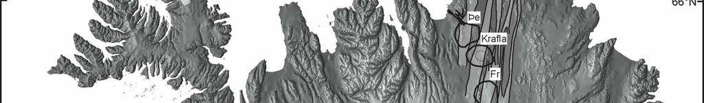
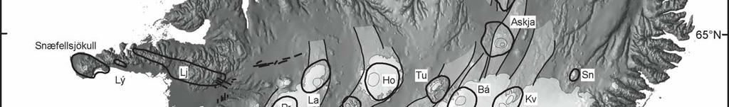
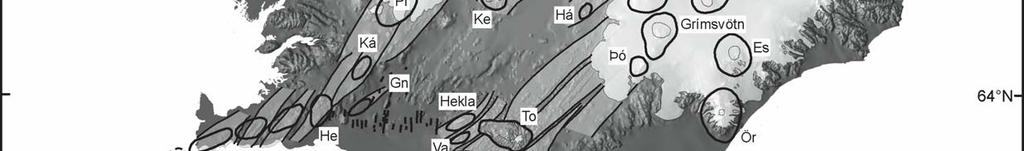
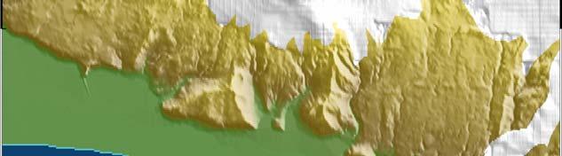
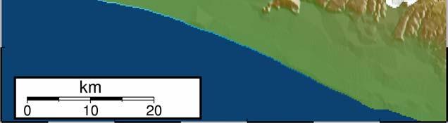
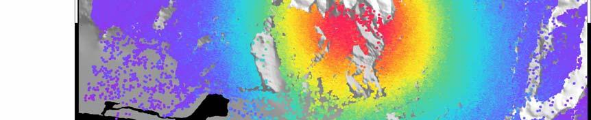
17 Eyjafjallajökull Volcano, Iceland Einarsson and Saemundsson [1987]
 10 km")

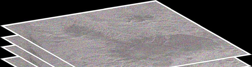
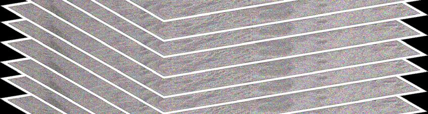
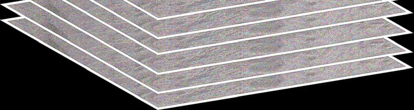
18 Comparison of PS and Small Baseline Pixels Single time period (Jun 1997 to Oct 1999) 10 km Persistent Scatterer pixels Both: 133,000 Small Baseline pixels PS pixels: 177,000 SB pixels: 659,000
19 Noise Statistics for Selected Pixels Pixels common to both analyses only
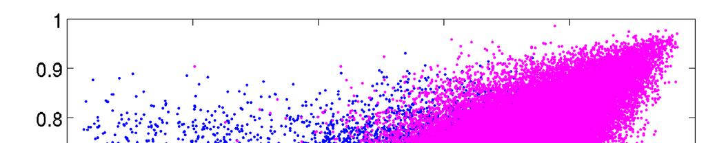
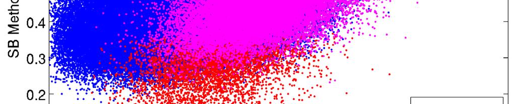
20 The Difference Filtering Makes
21 Multi-Temporal (Time Series) InSAR TS-InSAR Persistent Scatterer Methods Small Baseline Methods Combined Method


22 Combined Time Series InSAR Wrapped phase of pixels from both methods combined in Small Baseline Interferograms. For pixels selected by both methods, the weighted mean phase is calculated, with the weighting being an estimate of SNR.
23 Phase-Unwrapping in Space-Time wrapped phase unwrapped smoothly Phase between 2 neighbouring pixels UW Phase Time


24 2D (Space) Probability Density Functions Probability Density Probability φ 2π φ φ+2π φ+4π φ+6π Unwrapped phase difference between neighbouring pixels Peak probability at phase from unwrapping smoothly in space-time Distribution width from variation of wrapped phase from phase determined by unwrapping smoothly in space-time.


25 Combined Time Series InSAR Combined before phase-unwrapping Duplicates weighted according to signal-tonoise ratio
26 Deformation For Each Time Step After unwrapping, phase is inverted to give phase relative to single master. In this plot, each image includes only the deformation since the previous image.


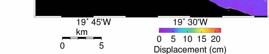
27 Variation in Deformation and Seismicity (Catalogue Earthquake locations from Iceland Meteorological Office) To May 1999 First days 70 days May 1999 to Aug 1999 Aug 1999 to Oct days Last days Oct 1999 to Aug LOS disp (cm) 14
28 Conclusions PS and Small Baseline methods select different but overlapping sets of pixels. The noise characteristics of a pixel varies, depending on the method used (filtering or no filtering). The methods can be combined to extract signal from more pixels, and with higher SNR, than either method can achieve alone.
Terrain Motion and Persistent Scatterer InSAR
 Terrain Motion and Persistent Scatterer InSAR Andy Hooper University of Leeds ESA Land Training Course, Gödöllő, Hungary, 4-9 th September, 2017 Good Interferogram 2011 Tohoku earthquake Good correlation
Persistent Scatterer InSAR
 Persistent Scatterer InSAR Andy Hooper University of Leeds Synthetic Aperture Radar: A Global Solution for Monitoring Geological Disasters, ICTP, 2 Sep 2013 Good Interferogram 2011 Tohoku earthquake Good
IMPACT OF BAQ LEVEL ON INSAR PERFORMANCE OF RADARSAT-2 EXTENDED SWATH BEAM MODES
 IMPACT OF BAQ LEVEL ON INSAR PERFORMANCE OF RADARSAT-2 EXTENDED SWATH BEAM MODES Jayson Eppler (1), Mike Kubanski (1) (1) MDA Systems Ltd., 13800 Commerce Parkway, Richmond, British Columbia, Canada, V6V
SARscape Modules for ENVI
 Visual Information Solutions SARscape Modules for ENVI Read, process, analyze, and output products from SAR data. ENVI. Easy to Use Tools. Proven Functionality. Fast Results. DEM, based on TerraSAR-X-1
21-Sep-11. Outline. InSAR monitoring of CO2 sequestration - Complications. Enhanced solution (novel spatiotemporal atmospheric filtering)
") Pushing the accuracy limit for CO2 sequestration monitoring: Statistically optimal spatio-temporal removal of the atmospheric component from InSAR Networks Bernhard Rabus Jayson Eppler MacDonald Dettwiler
Pushing the accuracy limit for CO2 sequestration monitoring: Statistically optimal spatio-temporal removal of the atmospheric component from InSAR Networks Bernhard Rabus Jayson Eppler MacDonald Dettwiler
EKATERINA TYMOFYEYEVA GMTSAR BATCH PROCESSING
 EKATERINA TYMOFYEYEVA GMTSAR BATCH PROCESSING THANK YOU! Xiaopeng Tong Xiaohua (Eric) Xu David Sandwell Yuri Fialko OUTLINE Batch processing scripts in GMTSAR (focus on Sentinel-1) SBAS: a method for calculating
How accurately can current and futureinsar missions map tectonic strain?
 How accurately can current and futureinsar missions map tectonic strain? Outline: How accurately do we need to measure strain? InSAR missions Error budget for InSAR Ability of current, planned and proposed
URBAN MONITORING USING PERSISTENT SCATTERER INSAR AND PHOTOGRAMMETRY
 URBAN MONITORING USING PERSISTENT SCATTERER INSAR AND PHOTOGRAMMETRY Junghum Yu *, Alex Hay-Man Ng, Sungheuk Jung, Linlin Ge, and Chris Rizos. School of Surveying and Spatial Information Systems, University
Warren Cartwright, Product Manager MDA Geospatial Services, Canada
 Advanced InSAR Techniques for Urban Infrastructure Monitoring Warren Cartwright, Product Manager MDA Geospatial Services, Canada www.mdacorporation.com RESTRICTION ON USE, PUBLICATION OR DISCLOSURE OF
High resolution ground deformations monitoring by COSMO-SkyMed PSP SAR interferometry
 High resolution ground deformations monitoring by COSMO-SkyMed PSP SAR interferometry Mario Costantini e-geos - an ASI/Telespazio Company, Rome, Italy mario.costantini@e-geos.it Summary COSMO-SkyMed satellite
Earth Observation and Sensing Technologies: a focus on Radar Imaging Developments. Riccardo Lanari
 Earth Observation and Sensing Technologies: a focus on Radar Imaging Developments Riccardo Lanari Institute for Electromagnetic Sensing of the Environment (IREA) National Research Council of Italy (CNR)
Monitoring of Bridge Deformation with InSAR: An Experimental Study
 XXIV FIG International Congress 2010 11-16 April 2010 Sydney, Australia Monitoring of Bridge Deformation with InSAR: An Experimental Study Lei Zhang 1, Xiaoli Ding 1 and Zhong Lu 2 1 Department of Land
EVALUATING THE EFFECT OF THE OBSERVATION TIME ON THE DISTRIBUTION OF SAR PERMANENT SCATTERERS
 EVALUATING THE EFFECT OF THE OBSERVATION TIME ON THE DISTRIBUTION OF SAR PERMANENT SCATTERERS Alessandro Ferretti (), Carlo Colesanti (), Daniele Perissin (), Claudio Prati (), and Fabio Rocca () () Tele-Rilevamento
EENG473 Mobile Communications Module 3 : Week # (12) Mobile Radio Propagation: Small-Scale Path Loss
 Mobile Radio Propagation: Small-Scale Path Loss") EENG473 Mobile Communications Module 3 : Week # (12) Mobile Radio Propagation: Small-Scale Path Loss Introduction Small-scale fading is used to describe the rapid fluctuation of the amplitude of a radio
EENG473 Mobile Communications Module 3 : Week # (12) Mobile Radio Propagation: Small-Scale Path Loss Introduction Small-scale fading is used to describe the rapid fluctuation of the amplitude of a radio
Detection of a Point Target Movement with SAR Interferometry
 Journal of the Korean Society of Remote Sensing, Vol.16, No.4, 2000, pp.355~365 Detection of a Point Target Movement with SAR Interferometry Jung-Hee Jun* and Min-Ho Ka** Agency for Defence Development*,
PSInSAR VALIDATION BY MEANS OF A BLIND EXPERIMENT USING DIHEDRAL REFLECTORS
 PSInSAR VALIDATION BY MEANS OF A BLIND EXPERIMENT USING DIHEDRAL REFLECTORS G. Savio (1), A. Ferretti (1) (2), F. Novali (1), S. Musazzi (3), C. Prati (2), F. Rocca (2) (1) Tele-Rilevamento Europa T.R.E.
Analysing Surface Deformation in Surabaya from Sentinel-1A Data using DInSAR Method
 Analysing Surface Deformation in Surabaya from Sentinel-1A Data using DInSAR Method Ira M. Anjasmara, Meiriska Yusfania, Akbar Kurniawan, Roni Kurniawan, Awalina L C Resmi Presenter Name Date of Birth
Exploring the Potential Pol-InSAR Techniques at X-Band: First Results & Experiments from TanDEM-X
 Exploring the Potential Pol-InSAR Techniques at X-Band: First Results & Experiments from TanDEM-X K. Papathanassiou, F. Kugler, J-S. Kim, S-K. Lee, I. Hajnsek Microwaves and Radar Institute (DLR-HR) German
Integration of InSAR and GPS for precise deformation mapping
 Integration of InSAR and GPS for precise deformation mapping Zhenhong Li (COMET, University of Glasgow, UK) Eric J. Fielding (Jet Propulsion Laboratory, Caltech, USA) 30 November 2009 Contents Two major
RADAR INTERFEROMETRY FOR SAFE COAL MINING IN CHINA
 RADAR INTERFEROMETRY FOR SAFE COAL MINING IN CHINA L. Ge a, H.-C. Chang a, A. H. Ng b and C. Rizos a Cooperative Research Centre for Spatial Information School of Surveying & Spatial Information Systems,
Nazemeh Ashrafianfar, Hans-Peter Hebel and Wolfgang Busch
 MONITORING OF MINING INDUCED LAND SUBSIDENCE - DIFFERENTIAL SAR INTERFEROMETRY AND PERSISTENT SCATTERER INTERFEROMETRY USING TERRASAR-X DATA IN COMPARISON WITH ENVISAT DATA ABSTRACT Nazemeh Ashrafianfar,
IEEE TRANSACTIONS ON GEOSCIENCE AND REMOTE SENSING 1
 IEEE TRANSACTIONS ON GEOSCIENCE AND REMOTE SENSING 1 InSAR Time-Series Estimation of the Ionospheric Phase Delay: An Extension of the Split Range-Spectrum Technique Heresh Fattahi, Member, IEEE, Mark Simons,
ASAR Training Course, Hanoi, 25 February 7 March 2008 Introduction to Radar Interferometry
 Introduction to Radar Interferometry Presenter: F.Sarti (ESA/ESRIN) 1 Imaging Radar : reminder 2 Physics of radar Potentialities of radar All-weather observation system (active system) Penetration capabilities
PALSAR SCANSAR SCANSAR Interferometry
 PALSAR SCANSAR SCANSAR Interferometry Masanobu Shimada Japan Aerospace Exploration Agency Earth Observation Research Center ALOS PI symposium, Greece Nov. 6 2008 1 Introduction L-band PALSAR strip mode
Generation of Fine Resolution DEM at Test Areas in Alaska Using ERS SAR Tandem Pairs and Precise Orbital Data *
 Generation of Fine Resolution DEM at Test Areas in Alaska Using ERS SAR Tandem Pairs and Precise Orbital Data * O. Lawlor, T. Logan, R. Guritz, R. Fatland, S. Li, Z. Wang, and C. Olmsted Alaska SAR Facility
Trainings and capacity buildings of space
 Trainings and capacity buildings of space technology, GIS and SAR products development for disaster management for DAN Dr. Masahiko NAGAI, Prof. Ryosuke Shibasaki Center for Spatial Information Science,
Written Exam Channel Modeling for Wireless Communications - ETIN10
 Written Exam Channel Modeling for Wireless Communications - ETIN10 Department of Electrical and Information Technology Lund University 2017-03-13 2.00 PM - 7.00 PM A minimum of 30 out of 60 points are
Environmental Impact Assessment of Mining Subsidence by Using Spaceborne Radar Interferometry
 Environmental Impact Assessment of Mining Subsidence by Using Spaceborne Radar Interferometry Hsing-Chung CHANG, Linlin GE and Chris RIZOS, Australia Key words: Mining Subsidence, InSAR, DInSAR, DEM. SUMMARY
Mobile Radio Propagation: Small-Scale Fading and Multi-path
 Mobile Radio Propagation: Small-Scale Fading and Multi-path 1 EE/TE 4365, UT Dallas 2 Small-scale Fading Small-scale fading, or simply fading describes the rapid fluctuation of the amplitude of a radio
Playa del Rey, California InSAR Ground Deformation Monitoring Interim Report H
 Playa del Rey, California InSAR Ground Deformation Monitoring Interim Report H Ref.: RV-14524 Doc.: CM-168-01 January 31, 2013 SUBMITTED TO: Southern California Gas Company 555 W. Fifth Street (Mail Location
Damage detection in the 2015 Nepal earthquake using ALOS-2 satellite SAR imagery
 Proceedings of the Tenth Pacific Conference on Earthquake Engineering Building an Earthquake-Resilient Pacific 6-8 November 2015, Sydney, Australia Damage detection in the 2015 Nepal earthquake using ALOS-2
OPTIMIZATION OF SATELLITE INSAR TECHNIQUES FOR MONITORING OF SUBSIDENCE IN THE SURROUNDINGS OF KARVINÁ MINE: LAZY PLANT
 Acta Geodyn. Geomater., Vol. 10, No. 1 (169), 51 55, 2013 OPTIMIZATION OF SATELLITE INSAR TECHNIQUES FOR MONITORING OF SUBSIDENCE IN THE SURROUNDINGS OF KARVINÁ MINE: LAZY PLANT Milan LAZECKÝ * and Eva
Lab Report 3: Speckle Interferometry LIN PEI-YING, BAIG JOVERIA
 Lab Report 3: Speckle Interferometry LIN PEI-YING, BAIG JOVERIA Abstract: Speckle interferometry (SI) has become a complete technique over the past couple of years and is widely used in many branches of
Radar remote sensing from space for monitoring deformations affecting urban areas and infrastructures
 Radar remote sensing from space for monitoring deformations affecting urban areas and infrastructures Riccardo Lanari IREA-CNR Napoli EGU2014, Vienna 30 April, 2014 Why Radar (SAR) Imaging from space?
Spectral coherence applied to vessel tracking
 Spectral coherence applied to vessel tracking Christian Barbier (cbarbier@ulg.ac.be) Dominique Derauw (dderauw@ulg.ac.be) Centre Spatial de Liège 2 Wide-band potential Recent sensors use wide band signals
Mobile Radio Propagation Channel Models
 Wireless Information Transmission System Lab. Mobile Radio Propagation Channel Models Institute of Communications Engineering National Sun Yat-sen University Table of Contents Introduction Propagation
Wireless Channel Propagation Model Small-scale Fading
 Wireless Channel Propagation Model Small-scale Fading Basic Questions T x What will happen if the transmitter - changes transmit power? - changes frequency? - operates at higher speed? Transmit power,
Digital Communications over Fading Channel s
 over Fading Channel s Instructor: Prof. Dr. Noor M Khan Department of Electronic Engineering, Muhammad Ali Jinnah University, Islamabad Campus, Islamabad, PAKISTAN Ph: +9 (51) 111-878787, Ext. 19 (Office),
RECENT ADVANCES IN THE CORRECTION OF IONOSPHERIC EFFECTS IN LOW-FREQUENCY SAR DATA
 RECENT ADVANCES IN THE CORRECTION OF IONOSPHERIC EFFECTS IN LOW-FREQUENCY SAR DATA F.J Meyer 1) 2), B. Watkins 3), J.S. Kim 4), K. Papathanassiou 4) 1)Earth & Planetary Remote Sensing, University of Alaska
Research Article Detection of Ground Moving Targets for Two-Channel Spaceborne SAR-ATI
 Hindawi Publishing Corporation EURASIP Journal on Advances in Signal Processing Volume, Article ID 78, 9 pages doi:.//78 Research Article Detection of Ground Moving Targets for Two-Channel Spaceborne SAR-ATI
Optical coherence tomography
 Optical coherence tomography Peter E. Andersen Optics and Plasma Research Department Risø National Laboratory E-mail peter.andersen@risoe.dk Outline Part I: Introduction to optical coherence tomography
Change detection in cultural landscapes
 9-11 November 2015 ESA-ESRIN, Frascati (Rome), Italy 3 rd ESA-EARSeL Course on Remote Sensing for Archaeology Day 3 Change detection in cultural landscapes DeodatoTapete (1,2) & Francesca Cigna (1,2) (1)
Propagation Channels. Chapter Path Loss
 Chapter 9 Propagation Channels The transmit and receive antennas in the systems we have analyzed in earlier chapters have been in free space with no other objects present. In a practical communication
Figure 1: C band and L band (SIR-C/X-SAR images of Flevoland in Holland). color scheme: HH: red, HV:green, VV: blue
. color scheme: HH: red, HV:green, VV: blue") L-band PS analysis: JERS-1 results and TerraSAR L predictions Kenji Daito (1), Alessandro Ferretti (), Shigeki Kuzuoka (3),Fabrizio Novali (), Pietro Panzeri (), Fabio Rocca (4) (1) Daido Institute of
L-band PS analysis: JERS-1 results and TerraSAR L predictions Kenji Daito (1), Alessandro Ferretti (), Shigeki Kuzuoka (3),Fabrizio Novali (), Pietro Panzeri (), Fabio Rocca (4) (1) Daido Institute of
MULTIPLE APERTURE INSAR (MAI) WITH C-BAND AND L-BAND DATA: NOISE AND PRECISION
 WITH C-BAND AND L-BAND DATA: NOISE AND PRECISION") MULTIPLE APERTURE INSAR (MAI) WITH C-BAND AND L-BAND DATA: NOISE AND PRECISION Noa Bechor Ben-Dov and Thomas A. Herring Massachusetts Institute of Technology, Cambridge, MA 2139, USA, Email: nbechor@chandler.mit.edu
MULTIPLE APERTURE INSAR (MAI) WITH C-BAND AND L-BAND DATA: NOISE AND PRECISION Noa Bechor Ben-Dov and Thomas A. Herring Massachusetts Institute of Technology, Cambridge, MA 2139, USA, Email: nbechor@chandler.mit.edu
UWB Small Scale Channel Modeling and System Performance
 UWB Small Scale Channel Modeling and System Performance David R. McKinstry and R. Michael Buehrer Mobile and Portable Radio Research Group Virginia Tech Blacksburg, VA, USA {dmckinst, buehrer}@vt.edu Abstract
Muhammad Ali Jinnah University, Islamabad Campus, Pakistan. Fading Channel. Base Station
 Fading Lecturer: Assoc. Prof. Dr. Noor M Khan Department of Electronic Engineering, Muhammad Ali Jinnah University, Islamabad Campus, Islamabad, PAKISTAN Ph: +9 (51) 111-878787, Ext. 19 (Office), 186 (ARWiC
Detection of Targets in Noise and Pulse Compression Techniques
 Introduction to Radar Systems Detection of Targets in Noise and Pulse Compression Techniques Radar Course_1.ppt ODonnell 6-18-2 Disclaimer of Endorsement and Liability The video courseware and accompanying
Incoherent Scatter Experiment Parameters
 Incoherent Scatter Experiment Parameters At a fundamental level, we must select Waveform type Inter-pulse period (IPP) or pulse repetition frequency (PRF) Our choices will be dictated by the desired measurement
Radar-Verfahren und -Signalverarbeitung
 Radar-Verfahren und -Signalverarbeitung - Lesson 2: RADAR FUNDAMENTALS I Hon.-Prof. Dr.-Ing. Joachim Ender Head of Fraunhoferinstitut für Hochfrequenzphysik and Radartechnik FHR Neuenahrer Str. 20, 53343
Dynamic Phase-Shifting Electronic Speckle Pattern Interferometer
 Dynamic Phase-Shifting Electronic Speckle Pattern Interferometer Michael North Morris, James Millerd, Neal Brock, John Hayes and *Babak Saif 4D Technology Corporation, 3280 E. Hemisphere Loop Suite 146,
Non-adaptive Wavefront Control
 OWL Phase A Review - Garching - 2 nd to 4 th Nov 2005 Non-adaptive Wavefront Control (Presented by L. Noethe) 1 Specific problems in ELTs and OWL Concentrate on problems which are specific for ELTs and,
Lecture 3: Wireless Physical Layer: Modulation Techniques. Mythili Vutukuru CS 653 Spring 2014 Jan 13, Monday
 Lecture 3: Wireless Physical Layer: Modulation Techniques Mythili Vutukuru CS 653 Spring 2014 Jan 13, Monday Modulation We saw a simple example of amplitude modulation in the last lecture Modulation how
Fringe Parameter Estimation and Fringe Tracking. Mark Colavita 7/8/2003
 Fringe Parameter Estimation and Fringe Tracking Mark Colavita 7/8/2003 Outline Visibility Fringe parameter estimation via fringe scanning Phase estimation & SNR Visibility estimation & SNR Incoherent and
Index 275. K Ka-band, 250, 259 Knowledge-based concepts, 110
 Index A Acquisition planning, 225 Across-track, 30, 41, 88, 90 93 Across-track interferometry, 30 Along-track, 3, 10, 19, 41, 88, 90, 91, 93, 94, 103 Along-track interferometry, 41 Ambiguous elevation
Understanding the performance of atmospheric free-space laser communications systems using coherent detection
 !"#$%&'()*+&, Understanding the performance of atmospheric free-space laser communications systems using coherent detection Aniceto Belmonte Technical University of Catalonia, Department of Signal Theory
ESA Radar Remote Sensing Course ESA Radar Remote Sensing Course Radar, SAR, InSAR; a first introduction
 Radar, SAR, InSAR; a first introduction Ramon Hanssen Delft University of Technology The Netherlands r.f.hanssen@tudelft.nl Charles University in Prague Contents Radar background and fundamentals Imaging
Radar phase based near surface meteorological data retrievals
 Radar phase based near surface meteorological data retrievals Author: Josep Ruiz Rodon Advisor: Joan Bech Rustullet Facultat de Física, Universitat de Barcelona, Diagonal 645, 828 Barcelona, Spain*. Abstract:
EFFECTS OF IONOSPHERIC SMALL-SCALE STRUCTURES ON GNSS
 EFFECTS OF IONOSPHERIC SMALL-SCALE STRUCTURES ON GNSS G. Wautelet, S. Lejeune, R. Warnant Royal Meteorological Institute of Belgium, Avenue Circulaire 3 B-8 Brussels (Belgium) e-mail: gilles.wautelet@oma.be
NETW 701: Wireless Communications. Lecture 5. Small Scale Fading
 NETW 701: Wireless Communications Lecture 5 Small Scale Fading Small Scale Fading Most mobile communication systems are used in and around center of population. The transmitting antenna or Base Station
HIGH RESOLUTION DIFFERENTIAL INTERFEROMETRY USING TIME SERIES OF ERS AND ENVISAT SAR DATA
 HIGH RESOLUTION DIFFERENTIAL INTERFEROMETRY USING TIME SERIES OF ERS AND ENVISAT SAR DATA Javier Duro 1, Josep Closa 1, Erlinda Biescas 2, Michele Crosetto 2, Alain Arnaud 1 1 Altamira Information C/ Roger
Chapter 2 Channel Equalization
 Chapter 2 Channel Equalization 2.1 Introduction In wireless communication systems signal experiences distortion due to fading [17]. As signal propagates, it follows multiple paths between transmitter and
Introduction to radar. interferometry
 Introduction to radar Introduction to Radar Interferometry interferometry Presenter: F.Sarti (ESA/ESRIN) With kind contribution by the Radar Department of CNES All-weather observation system (active system)
Decoding Galileo and Compass
 Decoding Galileo and Compass Grace Xingxin Gao The GPS Lab, Stanford University June 14, 2007 What is Galileo System? Global Navigation Satellite System built by European Union The first Galileo test satellite
 Performance Comparison between Dual Polarimetric and Fully Polarimetric data for DInSAR Subsidence monitoring Dani Monells, Jordi J. Mallorquí Universitat Politècnica de Catalunya, Departament de Teoria
Noise Tolerance of Improved Max-min Scanning Method for Phase Determination
 Noise Tolerance of Improved Max-min Scanning Method for Phase Determination Xu Ding Research Assistant Mechanical Engineering Dept., Michigan State University, East Lansing, MI, 48824, USA Gary L. Cloud,
BER ANALYSIS OF WiMAX IN MULTIPATH FADING CHANNELS
 BER ANALYSIS OF WiMAX IN MULTIPATH FADING CHANNELS Navgeet Singh 1, Amita Soni 2 1 P.G. Scholar, Department of Electronics and Electrical Engineering, PEC University of Technology, Chandigarh, India 2
Bit Error Rate Assessment of Digital Modulation Schemes on Additive White Gaussian Noise, Line of Sight and Non Line of Sight Fading Channels
 International Journal of Engineering Science Invention ISSN (Online): 2319 6734, ISSN (Print): 2319 6726 Volume 3 Issue 8 ǁ August 2014 ǁ PP.06-10 Bit Error Rate Assessment of Digital Modulation Schemes
DISPLACEMENT AND DEFORMATION MEASUREMENT USING GROUND RADAR INTERFEROMETRY TECHNIQUE
 JOURNAL OF APPLIED ENGINEERING SCIENCES Article Number: 124_VOL. 1(16), issue 1_2013, pp.111-118 ISSN 2247-3769 ISSN-L 2247-3769 (Print) / e-issn:2284-7197 DISPLACEMENT AND DEFORMATION MEASUREMENT USING
Client: Statens vegvesen, Region midt County: Sør Trondelag
 Geological Survey of Norway N-7441 Trondheim, Norway REPORT Report no.: 2004.043 ISSN 0800-3416 Grading: Open Title: Preliminary analysis of InSAR data over Trondheim with respect to future road development
Wideband, Long-CPI GMTI
 Wideband, Long-CPI GMTI Ali F. Yegulalp th Annual ASAP Workshop 6 March 004 This work was sponsored by the Defense Advanced Research Projects Agency and the Air Force under Air Force Contract F968-00-C-000.
Performance Evaluation of OFDM System with Rayleigh, Rician and AWGN Channels
 Performance Evaluation of OFDM System with Rayleigh, Rician and AWGN Channels Abstract A Orthogonal Frequency Division Multiplexing (OFDM) scheme offers high spectral efficiency and better resistance to
Part 4. Communications over Wireless Channels
 Part 4. Communications over Wireless Channels p. 1 Wireless Channels Performance of a wireless communication system is basically limited by the wireless channel wired channel: stationary and predicable
Fundamentals of Remote Sensing: SAR Interferometry
 INSIS Fundamentals of Remote Sensing: SAR Interferometry Notions fondamentales de télédétection : l interférométrie RSO Gabriel VASILE Chargé de Recherche CNRS gabriel.vasile@gipsa-lab.grenoble-inp.fr
Satellite Navigation Principle and performance of GPS receivers
 Satellite Navigation Principle and performance of GPS receivers AE4E08 GPS Block IIF satellite Boeing North America Christian Tiberius Course 2010 2011, lecture 3 Today s topics Introduction basic idea
Th P6 01 Retrieval of the P- and S-velocity Structure of the Groningen Gas Reservoir Using Noise Interferometry
 Th P6 1 Retrieval of the P- and S-velocity Structure of the Groningen Gas Reservoir Using Noise Interferometry W. Zhou* (Utrecht University), H. Paulssen (Utrecht University) Summary The Groningen gas
Broadband Temporal Coherence Results From the June 2003 Panama City Coherence Experiments
 Broadband Temporal Coherence Results From the June 2003 Panama City Coherence Experiments H. Chandler*, E. Kennedy*, R. Meredith*, R. Goodman**, S. Stanic* *Code 7184, Naval Research Laboratory Stennis
Module 12 : System Degradation and Power Penalty
 Module 12 : System Degradation and Power Penalty Lecture : System Degradation and Power Penalty Objectives In this lecture you will learn the following Degradation during Propagation Modal Noise Dispersion
Intelligent Approach to Improve Standard CFAR Detection in non-gaussian Sea Clutter THESIS
 Intelligent Approach to Improve Standard CFAR Detection in non-gaussian Sea Clutter THESIS Presented in Partial Fulfillment of the Requirements for the Degree Master of Science in the Graduate School of
Unit 8 - Week 7 - Computer simulation of Rayleigh fading, Antenna Diversity
 X Courses» Introduction to Wireless and Cellular Communications Announcements Course Forum Progress Mentor Unit 8 - Week 7 - Computer simulation of Rayleigh fading, Antenna Diversity Course outline How
38123 Povo Trento (Italy), Via Sommarive 14
, Via Sommarive 14") UNIVERSITY OF TRENTO DIPARTIMENTO DI INGEGNERIA E SCIENZA DELL INFORMAZIONE 38123 Povo Trento (Italy), Via Sommarive 14 http://www.disi.unitn.it AN INVESTIGATION ON UWB-MIMO COMMUNICATION SYSTEMS BASED
UNIVERSITY OF TRENTO DIPARTIMENTO DI INGEGNERIA E SCIENZA DELL INFORMAZIONE 38123 Povo Trento (Italy), Via Sommarive 14 http://www.disi.unitn.it AN INVESTIGATION ON UWB-MIMO COMMUNICATION SYSTEMS BASED
Target Echo Information Extraction
 Lecture 13 Target Echo Information Extraction 1 The relationships developed earlier between SNR, P d and P fa apply to a single pulse only. As a search radar scans past a target, it will remain in the
Evaluation of SNR for AWGN, Rayleigh and Rician Fading Channels Under DPSK Modulation Scheme with Constant BER
 International Journal of Wireless Communications and Mobile Computing 2015; 3(1): 7-12 Published online February 6, 2015 (http://www.sciencepublishinggroup.com/j/wcmc) doi: 10.11648/j.wcmc.20150301.12
Antennas and Propagation. Chapter 6b: Path Models Rayleigh, Rician Fading, MIMO
 Antennas and Propagation b: Path Models Rayleigh, Rician Fading, MIMO Introduction From last lecture How do we model H p? Discrete path model (physical, plane waves) Random matrix models (forget H p and
COMPARATIVE ANALYSIS OF INSAR DIGITAL SURFACE MODELS FOR TEST AREA BUCHAREST
 COMPARATIVE ANALYSIS OF INSAR DIGITAL SURFACE MODELS FOR TEST AREA BUCHAREST Iulia Dana (1), Valentin Poncos (2), Delia Teleaga (2) (1) Romanian Space Agency, 21-25 Mendeleev Street, 010362, Bucharest,
Wireless Communication: Concepts, Techniques, and Models. Hongwei Zhang
 Wireless Communication: Concepts, Techniques, and Models Hongwei Zhang http://www.cs.wayne.edu/~hzhang Outline Digital communication over radio channels Channel capacity MIMO: diversity and parallel channels
PACS. PACS Photometer glitch analysis on the electronics. Herschel. PACS Photometer glitch analysis on the electronics Page 1. K.
 PACS Photometer glitch analysis on the electronics Page 1 PACS Photometer glitch analysis on the electronics K. Okumura PACS Photometer glitch analysis on the electronics Page 2 Req. 1.1.9bis Glitches
Francesco Holecz. TUBE II meeting - 17 June Land Degradation. Land Degradation
 Land Degradation Francesco Holecz Objective To identify and monitor land degraded areas, in particular those related to agricultural and pastoral activities. Following products are generated: Land cover
Comparison between SAR atmospheric phase screens at 30 by means of ERS and ENVISAT data
 Fringe 2007 - ESA-ESRIN - Frascati, November 28, 2007 Comparison between SAR atmospheric phase screens at 30 by means of ERS and ENVISAT data D. Perissin Politecnico di Milano Tele-Rilevamento Europa -
Comparisons of Speckle Noise Filtering Methods on Interferometric Synthetic Aperture Radar Images
 908 JOURNAL OF COMPUTERS, VOL. 9, NO. 4, APRIL 2014 Comparisons of Speckle Noise Filtering Methods on Interferometric Synthetic Aperture Radar Images Yifei Chen Department of Electronic & Information Engineering,
Fringe 2015 Workshop
 Fringe 2015 Workshop On the Estimation and Interpretation of Sentinel-1 TOPS InSAR Coherence Urs Wegmüller, Maurizio Santoro, Charles Werner and Oliver Cartus Gamma Remote Sensing AG - S1 IWS InSAR and
Exam 3 is two weeks from today. Today s is the final lecture that will be included on the exam.
 ECE 5325/6325: Wireless Communication Systems Lecture Notes, Spring 2010 Lecture 19 Today: (1) Diversity Exam 3 is two weeks from today. Today s is the final lecture that will be included on the exam.
Research Article Performance Evaluation of Azimuth Offset Method for Mitigating the Ionospheric Effect on SAR Interferometry
 Hindawi Journal of Sensors Volume 217, Article ID 4587475, 1 pages https://doi.org/1.1155/217/4587475 Research Article Performance Evaluation of Azimuth Offset Method for Mitigating the Ionospheric Effect
SARscape for ENVI. A Complete SAR Analysis Solution
 SARscape for ENVI A Complete SAR Analysis Solution IDL and ENVI A Foundation for SARscape IDL The Data Analysis & Visualization Platform Data Access: IDL supports virtually every data format, type and
Antennas and Propagation. Chapter 6d: Diversity Techniques and Spatial Multiplexing
 Antennas and Propagation d: Diversity Techniques and Spatial Multiplexing Introduction: Diversity Diversity Use (or introduce) redundancy in the communications system Improve (short time) link reliability
CHAPTER 2 WIRELESS CHANNEL
 CHAPTER 2 WIRELESS CHANNEL 2.1 INTRODUCTION In mobile radio channel there is certain fundamental limitation on the performance of wireless communication system. There are many obstructions between transmitter
EVALUATION OF BINARY PHASE CODED PULSE COMPRESSION SCHEMES USING AND TIME-SERIES WEATHER RADAR SIMULATOR
 7.7 1 EVALUATION OF BINARY PHASE CODED PULSE COMPRESSION SCHEMES USING AND TIMESERIES WEATHER RADAR SIMULATOR T. A. Alberts 1,, P. B. Chilson 1, B. L. Cheong 1, R. D. Palmer 1, M. Xue 1,2 1 School of Meteorology,
Narrow- and wideband channels
 RADIO SYSTEMS ETIN15 Lecture no: 3 Narrow- and wideband channels Ove Edfors, Department of Electrical and Information technology Ove.Edfors@eit.lth.se 2012-03-19 Ove Edfors - ETIN15 1 Contents Short review
Synthetic Aperture Radar Interferometry (InSAR) Technique (Lecture I- Tuesday 11 May 2010)
 Technique (Lecture I- Tuesday 11 May 2010)") Synthetic Aperture Radar Interferometry () Technique (Lecture I- Tuesday 11 May 2010) ISNET/CRTEAN Training Course on Synthetic Aperture Radar (SAR) Imagery: Processing, Interpretation and Applications
Synthetic Aperture Radar Interferometry () Technique (Lecture I- Tuesday 11 May 2010) ISNET/CRTEAN Training Course on Synthetic Aperture Radar (SAR) Imagery: Processing, Interpretation and Applications
Computational Complexity of Multiuser. Receivers in DS-CDMA Systems. Syed Rizvi. Department of Electrical & Computer Engineering
 Computational Complexity of Multiuser Receivers in DS-CDMA Systems Digital Signal Processing (DSP)-I Fall 2004 By Syed Rizvi Department of Electrical & Computer Engineering Old Dominion University Outline