The SMOS Field Campaigns Status report on 10 May 2006
|
|
|
- Buck Sutton
- 5 years ago
- Views:
Transcription
1 Page 1/22 The SMOS Field Campaigns Status report on 10 May 2006 Patrick Wursteisen
2 Presentation structure Page 2/22 Earlier campaigns for initial work on SMOS: WISE experiments at Oil Platform near Barcelona in EuroSTARRS experiment in 2001, airborne campaign over Atlantic and Barcelona LOSAC campaign, airborne campaign in over North Sea Campaigns performed since 5th SMOS Workshop: DOMEX Campaign in Antarctica, tower-based measurements December CoSMOS-2, Airborne measurements in Australia in Nov CoSMOS-OS, Airborne measurements in Norway in April 2006

3 WISE, Eurostarrs, LOSAC Campaigns Page 3/22 WISE (Wind and Ocean Exp) in at Oil drilling platform in Barcelona provide L-band polarimetric radiometer data EuroSTARRS, based on US instrument STARSS, Flights in Nov 2001 over Gascogne and Oil platform. LOSAC, airborne campaign in with L-band rad. from TUD, several flights with variable wind conditions. Interesting data set, discovery of wiggles

4 DOMEX-2005 Page 4/22 DOMEX Campaign organised with CNR-IFAC, Florence, Italy Campaign took place in Dec 2004 at DOME-CONCORDIA in Antarctica. Measurements from a tower Use of an L-band radiometer and a C-band radiometer Data not yet provided. Due shortly. Activity concluded in Oct 2005.

5 DOMEX-2005, DOME-C base Page 5/22 35 m Tower Protected Area 800 m Winter base Summer base

6 CoSMOS-OS Salinity Campaign Page 6/22 CoSMOS-1 Cancelled CoSMOS-2 dedicated to SM measurements CoSMOS-OS dedicated to OS measurements
7 CoSMOS-2 in Australia Page 7/22 Campaign organised at very short notice as a recovery from CoSMOS-2005 campaign, cancelled after unavailability of aircraft. Cooperation with Australian Univ. Melbourne, Newcastle in frame of the National Australian Field Experiment (NAFE), coord. Jeff Walker. Participation of European Teams (Free Univ. Amsterdam, Univ. Valencia, CESBIO) Use of Aero Commander Aircraft from Univ. Flinders, Adelaide. TUD had to redesign interfaces of radiometer to aircraft.
8 CoSMOS-2 Campaign Objectives Page 8/22 Objective of the CoSMOS airborne campaign is to perform a long-term acquisition of data under different geo/bio-physical as well as meteorological and oceanographic conditions to address open issues related to the retrieval and validation of the SMOS products. Following points need to be addressed: Provision of data for validating and testing the assimilation of L-band brightness temperatures in a near-operational context, Provision of data for solving retrieval problems over the ocean, Detailing and testing of the SMOS validation approach, Development of better models relating brightness temperature and wind/wave conditions,

9 CoSMOS-2 Field Operations Page 9/22


10 CoSMOS-2, Field Operations, Merriwa area Page 10/22 Large area of 50 x 50 km 2 26 SM Stations over 8 farms

 Diamond ECO")
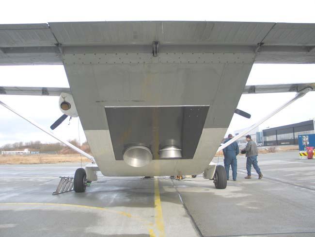
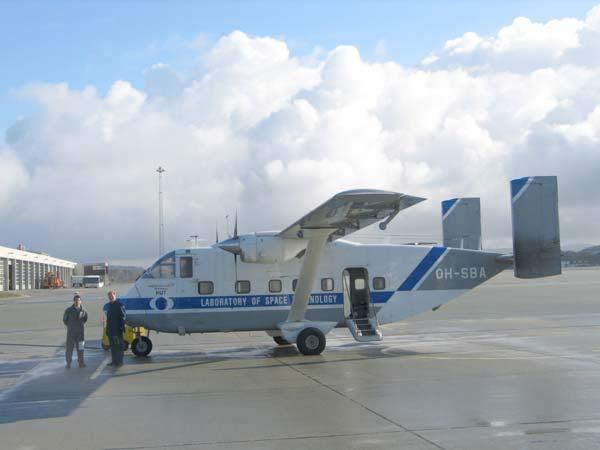
11 CoSMOS-2, Airborne Operations, Scone Airport Page 11/22 The L-band radiometer horns (TUD) Aero Commander (CoSMOS-2) Diamond ECO Dimona (NAFE)
12 CoSMOS-2, Flight Operations Page 12/22 October 2005 November 2005 December Campaign operations and Flights flights delayed due to delays in certification campaign extension <== end of Campaign Assimilation of root zone soil moisture ASSI Scaling issues, 2000 metres alt. Sun Glint and Topography SCAL GLINT 1 flight over Roscommon with NAFE on first day Effect of Water and dew on L-band measurements WATER second flight during last NAFE vegetation sampling
13 CoSMOS-2, Conclusions Page 13/22 Very successful campaign, organised as a piggy back to Australian NAFE project. High temperatures in November, and no airco in plane Impact on temperature Stability and Characterization of radiometer. First radiometer data have been delivered to ESA but need to be re-processed with proper T corrections. Ground data available to NAFE/CoSMOS Participants via FTP.
14 CoSMOS-OS, Campaign Objectives Page 14/22 Objective of the CoSMOS-OS airborne campaign is to perform the acquisition of data under different oceanographic conditions to address open issues related to the retrieval and validation of the SMOS products. Specifically, the following points need to be addressed in this campaign: Provision of data for validating and testing the assimilation of L-band brightness temperatures in a near-operational context, Provision of data for solving retrieval problems over the ocean, Detailing and testing of the SMOS validation approach, Development of better models relating brightness temperature and wind/wave conditions,
15 CoSMOS-2, Campaign organisation Page 15/22 EMIRAD radiometer from TUD, Thermal infrared radiometer in nose of aircraft Paris GPS system from IEEC, Barcelona. all embarked on Skyvan from HUT/TKK, Finland. Campaign based in Stavanger, Norway. In-situ measurements provided by NIVA and Oil drilling Platforms Campaign 4 weeks in April 2006, 12 Flights 8 OS flights, at night, 4 OS Sun-glint flights in the morning. Flights concurrent to ENVISAT ASAR overflight Support of BOOST/IFREMER (F) for exploitation of ASAR data and Flight Planning.

16 CoSMOS-OS, Implementation of EMIRAD radiometer Page 16/22


17 CoSMOS-OS, Flight patterns Circle flights Page 17/22 Sun Glint flights


18 CoSMOS-OS, ASAR data Exploitation Page 18/22 An example of exploitation of ASAR data at BOOST to support the Flight Operations.

19 CoSMOS-OS, Flight Operations Page 19/22
20 CoSMOS-OS, Conclusions Page 20/22 Flight Operations concluded very recently (end April 2006), Successful campaign, accurate flights execution, Good cooperation with Norwegian partners at NIVA and met. Office, Nominal Data Acquisition with radiometer, Large range of sea-surface winds, Some flights performed without ASAR data due to ENVISAT shutdown, or conflict with commercial user, No L-band data provided yet, but is important to process and provide them rapidly to the Science community,
21 Campaign in Preparation, DOMEX-2 Page 21/22 DOMEX-2 RFQ currently in preparation Radiometer will be modified to improve Thermal behavior, and be prepared for Acquisition in Winter. Cooperation between IFAC and ESTEC Thermal experts, Long-duration campaign months at Dome-C starting end 2007, ESA to finance radiometer dev. Other funding required for logistics, and data acquisition. Winter base at DOME-C
22 Other Future activities Page 22/22 Other Campaigns, and supporting Field activities: Announcement of Opportunity: Some 40 Proposals from Scientists Worldwide, No financial support considered from ESA, but see directly with SMOS project manager for confirmation. AO not discussed further in this presentation. NO other Field campaigns scheduled, NO other Airborne campaigns scheduled.
Assessment of instrument STability and Retrieval Algorithms for SMOS data (ASTRA)
") Assessment of instrument STability and Retrieval Algorithms for SMOS data (ASTRA) S.Paloscia IFAC-CNR MRSG - Microwave Remote Sensing Group Florence (Italy) Microwave Remote Sensing Group I - DOMEX-2 :
Assessment of instrument STability and Retrieval Algorithms for SMOS data (ASTRA) S.Paloscia IFAC-CNR MRSG - Microwave Remote Sensing Group Florence (Italy) Microwave Remote Sensing Group I - DOMEX-2 :
L-band brightness temperature at Dome-C Antarctica: intercomparison between DOMEX-3, SMOS and Aquarius data
 SMOS & AQUARIUS SCIENCE WORKSHOP Brest 15 17 April 2013 L-band brightness temperature at Dome-C Antarctica: intercomparison between DOMEX-3, SMOS and Aquarius data Marco Brogioni, Giovanni Macelloni, Simone
CoSMOS: Performance of Kurtosis Algorithm for Radio Frequency Interference Detection and Mitigation
 Downloaded from orbit.dtu.dk on: Jul 4, 18 CoSMOS: Performance of Kurtosis Algorithm for Radio Frequency Interference Detection and Mitigation Misra, Sidharth; Kristensen, Steen Savstrup; Skou, Niels;
1. SMOS Status 1.1 Payload 1.2 Platform 1.3 Satellite 1.4 Launcher 1.5 FOS 1.6 DPGS 2. Other Developments 3. Future (Near & Far) 4.
 4.") 1. SMOS Status 1.1 Payload 1.2 Platform 1.3 Satellite 1.4 Launcher 1.5 FOS 1.6 DPGS 2. Other Developments 3. Future (Near & Far) 4. Schedule 1 1.1 Payload General: Structural / Thermal Model test campaigns
1. SMOS Status 1.1 Payload 1.2 Platform 1.3 Satellite 1.4 Launcher 1.5 FOS 1.6 DPGS 2. Other Developments 3. Future (Near & Far) 4. Schedule 1 1.1 Payload General: Structural / Thermal Model test campaigns
GNSS-R for studies of the cryosphere
 GNSS-R for studies of the cryosphere F. Fabra 1, E. Cardellach 1, O. Nogués-Correig 1, S. Oliveras 1, S. Ribó 1, J.C. Arco 1, A. Rius 1, M. Belmonte-Rivas 2, M. Semmling 3, G. Macelloni 4, S. Pettinato
How to Access EO Data
 How to Access EO Data Andrea Minchella 29 June 2009, D1L1 ESA CAT-1 EO Principal Investigator ESA PIs and Projects 1-10 projects 11-20 projects 21-40 projects 41-60 projects 61-100 projects 101-200 projects
The ERS contribution to Oil Spill Monitoring - From R&D towards an operational service -
 The ERS contribution to Oil Spill Monitoring - From R&D towards an operational service - J.P. Pedersen, T.Bauna, L.G. Seljelv, L. Steinbakk, R.T.Enoksen Tromsø Satellite Station, N-9291 Tromsø, Norway
The use of satellite images to forecast agricultural
 The use of satellite images to forecast agricultural Luxembourg, 12.03.2014 r. Tomasz Milewski NUTS for Poland: NUTS 1 macro-regions (grup of province, voivodships) (6), NUTS 2 - regions (province,
The Sentinel-1 Constellation
 The Sentinel-1 Constellation Evert Attema, Sentinel-1 Mission & System Manager AGRISAR and EAGLE Campaigns Final Workshop 15-16 October 2007 ESA/ESTECNoordwijk, The Netherlands Sentinel-1 Programme Sentinel-1
Some Examples Airborne Remote Sensing of Soil Moisture
 COMBINING FULL WAVE-FORM LASER SCANNING, HYPER- SPECTRAL SCANNING AND OTHER REMOTE SENSING AND IN-SITU INSTRUMENTATION ON A SMALL AND ENVIRONMENTALLY FRIENDLY AIRBORNE PLATFORM - TECHNOLOGY AND SOME EXAMPLES
Soil moisture retrieval using ALOS PALSAR
 Soil moisture retrieval using ALOS PALSAR T. J. Jackson, R. Bindlish and M. Cosh USDA ARS Hydrology and Remote Sensing Lab, Beltsville, MD J. Shi University of California Santa Barbara, CA November 6,
RADIOMETER signals received in the L- and C-bands
 1398 IEEE TRANSACTIONS ON GEOSCIENCE AND REMOTE SENSING, VOL. 48, NO. 3, MARCH 2010 L-Band RFI as Experienced During Airborne Campaigns in Preparation for SMOS Niels Skou, Fellow, IEEE, Sidharth Misra,
SAR missions for oceanography at the European Space Agency
 SAR missions for oceanography at the European Space Agency ERS-1, ERS-2, Envisat, Sentinel-1A, Sentinel-1B, ESA 3 rd Party Missions (ALOS) Prepared by ESA teams and ESA supporting companies ESA and SAR
EE 529 Remote Sensing Techniques. Introduction
 EE 529 Remote Sensing Techniques Introduction Course Contents Radar Imaging Sensors Imaging Sensors Imaging Algorithms Imaging Algorithms Course Contents (Cont( Cont d) Simulated Raw Data y r Processing
GNSS-R for Land Bio-Geophysical Parameters Monitoring: the LEiMON Project
 GNSS-R for Land Bio-Geophysical Parameters Monitoring: the LEiMON Project Alejandro Egido(1), Marco Caparrini(1), Leila Guerriero(2), Nazzareno Pierdicca(2), Simonetta Paloscia(3), Marco Brogioni(3), Nicolas
Microwave - the SMOS Mission
 Microwave - the SMOS Mission Prof. Bob Su prepared by Monday 29 June 2009, D1L3a Part 1 SMOS MIRAS SMOS - Soil Moisture Ocean Salinity MIRAS - Microwave Imaging Radiometer using Aperture Synthesis Passive
Towards Sentinel-1 Soil Moisture Data Services: The Approach taken by the Earth Observation Data Centre for Water Resources Monitoring
 Towards Sentinel-1 Soil Moisture Data Services: The Approach taken by the Earth Observation Data Centre for Water Resources Monitoring Wolfgang Wagner wolfgang.wagner@geo.tuwien.ac.at Department of Geodesy
Remote sensing radio applications/ systems for environmental monitoring
 Remote sensing radio applications/ systems for environmental monitoring Alexandre VASSILIEV ITU Radiocommunication Bureau phone: +41 22 7305924 e-mail: alexandre.vassiliev@itu.int 1 Source: European Space
ASAR acquisition strategy for IPY -Update-
 ASAR acquisition strategy for IPY -Update- Jorge Del Rio Vera Henri Laur Presentation contents: 1. Background 2. ASAR Acquisition strategy update Tandem Campaign ICESat support campaign Wilkins Iceshelf
Microwave Sensors Subgroup (MSSG) Report
 Report") Microwave Sensors Subgroup (MSSG) Report Feb 17-20, 2014, ESA ESRIN, Frascati, Italy DONG, Xiaolong, MSSG Chair National Space Science Center Chinese Academy of Sciences (MiRS,NSSC,CAS) Email: dongxiaolong@mirslab.cn
Microwave Sensors Subgroup (MSSG) Report Feb 17-20, 2014, ESA ESRIN, Frascati, Italy DONG, Xiaolong, MSSG Chair National Space Science Center Chinese Academy of Sciences (MiRS,NSSC,CAS) Email: dongxiaolong@mirslab.cn
KONGSBERG SATELLITE SERVICES 2017 Line Steinbakk, Director Programs. Himmel og hav - Ålesund 3. Oktober 2017
 KONGSBERG SATELLITE SERVICES 2017 Line Steinbakk, Director Programs Himmel og hav - Ålesund 3. Oktober 2017 KSAT HQ IN TROMSØ 69N Established in 1967 Kongsberg Satellite Services since 2002 World leading
ESA SUPPORT TO EARTH OBSERVATION PRINCIPAL INVESTIGATORS: PREPARING FOR THE NEXT GENERATION
 ESA SUPPORT TO EARTH OBSERVATION PRINCIPAL INVESTIGATORS: PREPARING FOR THE NEXT GENERATION Yves-Louis Desnos (1), Peter Regner (1), Rita Malosti (2), Francesco Palazzo (2), Muriel Simon (2) (1) ESA-ESRIN,
GNSS Reflections over Ocean Surfaces
 GNSS Reflections over Ocean Surfaces State of the Art F. Soulat CCT Space Reflectometry December 1st 2010 Page n 1 Outline Concept GNSS-R Signal On-going Activities ( Applications) CLS GNSS-R Studies CCT
Marine. Status of the Copernicus Marine service with MyOcean2. Pierre Bahurel, Mercator Ocean FP7 MyOcean2 coordinator
 Marine Status of the Copernicus Marine service with MyOcean2 Pierre Bahurel, Mercator Ocean FP7 MyOcean2 coordinator Geneva, 16/01/2014 http:// (1) Status of the Copernicus Marine service demonstrated
Small UAV Radiocommunication Channel Characterization
 Small UAV Radiocommunication Channel Characterization Jordi Romeu, Albert Aguasca, Javier Alonso, Sebastián Blanch, Ricardo R. Martins AntennaLab, Dpt. Signal Theory and Communications. Universitat Politecnica
Proba-V QWG#7 Flight & GS status. 3 4 May 2018 ACRI, Sophia-Antipolis
 Proba-V QWG#7 Flight & GS status 3 4 May 2018 ACRI, Sophia-Antipolis Orbit status Slide 2 Orbit status LTDN evolution: 7 May 2013: 10:44:30 1 Dec. 2014: 10:51:08 26 Apr. 2017: 10:36:26 Oct 2017: 10:30
BeiDou: Bring the World and China to Your Doorstep
 IGS Workshop 2012-ICG Working Group A BeiDou: Bring the World and China to Your Doorstep China Satellite Navigation Office 2012.7.25 Olsztyn, Poland 1 Contents I. Development Schemes II. Performance III.
CNES PRIORITIES IN POLAR AND CRYOSPHERE RESEARCH
 Polar Space Task Group 3rd Session CNES PRIORITIES IN POLAR AND CRYOSPHERE RESEARCH Juliette Lambin, Steven Hosford Wednesday, May 22th, 2013 Paris, France 1 OUTLINE CNES MISSIONS FOR POLAR/CRYOSPHERE
SHIP DETECTION AND SEA CLUTTER CHARACTERISATION USING X&L BAND FULL-POLARIMETRIC AIRBORNE SAR DATA
 SHIP DETECTION AND SEA CLUTTER CHARACTERISATION USING X&L BAND FULL-POLARIMETRIC AIRBORNE SAR DATA S. Angelliaume, Ph. Martineau (ONERA) Ph. Durand, T. Cussac (CNES) Context CNES/ONERA study of Space System
The Typhoon Investigation using GNSS-R Interferometric Signals (TIGRIS)
") The Typhoon Investigation using GNSS-R Interferometric Signals (TIGRIS) F. Fabra 1, W. Li 2, M. Martín-Neira 3, S. Oliveras 1, A. Rius 1, W. Yang 2, D. Yang 2 and Estel Cardellach 1 1 Institute of Space
The Typhoon Investigation using GNSS-R Interferometric Signals (TIGRIS) F. Fabra 1, W. Li 2, M. Martín-Neira 3, S. Oliveras 1, A. Rius 1, W. Yang 2, D. Yang 2 and Estel Cardellach 1 1 Institute of Space
WORKSHOP AND GROUP SHOOT AIRBORNE HYPERSPECTRAL REMOTE SENSING. April 21 to April 30, 2009 Airfield Wiener Neustadt, AUSTRIA
 WORKSHOP AND GROUP SHOOT AIRBORNE HYPERSPECTRAL REMOTE SENSING April 21 to April 30, 2009 Airfield Wiener Neustadt, AUSTRIA INVITATION TO PARTICIPATE DIAMOND Airbone Sensing GmbH, Wiener Neustadt, AUSTRIA
For personal use only
 3D Oil Limited Level 5, 164 Flinders Lane Melbourne VIC 3000 Tel: +61 3 9650 9866 Fax: +61 3 9639 1960 www.3doil.com.au ASX Release 16 April 2013 West Seahorse Oil Field: Concept selected and FEED commenced
From Sea Ice Research to Aalto Satellites: 40+ Years of Remote Sensing and Space Technology Research
 From Sea Ice Research to Aalto Satellites: 40+ Years of Remote Sensing and Space Technology Research Martti Hallikainen Aalto University School of Electrical Engineering Department of Radio Science and
RADARSAT-2 Program Update Daniel De Lisle Canadian Space Agency
 RADARSAT-2 Program Update Daniel De Lisle Canadian Space Agency Presentation outline RADARSAT-1 Update RADARSAT-2 Mission description Mission Objectives System Characteristics Data Commercialization/Allocation
X-WALD. Avionic X-band Weather signal modeling and processing validation through real Data acquisition and analysis
 X-WALD Avionic X-band Weather signal modeling and processing validation through real Data acquisition and analysis State of the art Background All civil airplanes and military transport aircrafts are equipped
Passive Microwave Sensors LIDAR Remote Sensing Laser Altimetry. 28 April 2003
 Passive Microwave Sensors LIDAR Remote Sensing Laser Altimetry 28 April 2003 Outline Passive Microwave Radiometry Rayleigh-Jeans approximation Brightness temperature Emissivity and dielectric constant
European Space Agency and IPY
 European Space Agency and IPY ESA supports IPY 2007-2008 activities: First ESA step was a dedicated Announcement Opportunity (AO) for EO data provision in support IPY, released in 2006, with data provision
Copernicus Introduction Lisbon, Portugal 13 th & 14 th February 2014
 Copernicus Introduction Lisbon, Portugal 13 th & 14 th February 2014 Contents Introduction GMES Copernicus Six thematic areas Infrastructure Space data An introduction to Remote Sensing In-situ data Applications
SAOCOM-CS Mission and ESA Airborne Campaign Data
 SAOCOM-CS Mission and ESA Airborne Campaign Data Malcolm Davidson Head of the EOP Campaign Section Malcolm.Davidson@esa.int Objectives of presentation Introduce a new type of ESA SAR mission with Polarimetrice,
AGRON / E E / MTEOR 518: Microwave Remote Sensing
 AGRON / E E / MTEOR 518: Microwave Remote Sensing Dr. Brian K. Hornbuckle, Associate Professor Departments of Agronomy, ECpE, and GeAT bkh@iastate.edu What is remote sensing? Remote sensing: the acquisition
CAL/VAL activities for hyperspectral sensors at San Rossore test area
 CONSIGLIO NAZIONALE DELLE RICERCHE Istituto di Fisica Applicata Nello Carrara Sesto Fiorentino - ITALIA CAL/VAL activities for hyperspectral sensors at San Rossore test area Donatella Guzzi, Cinzia Lastri,
How to access EO data
 How to access EO data PAC USF USF PDHS LRAC USCF PDCC Europe s expanding EO Capability Continuity & Evolution Wind Scatterometer (Low rate) all weather; day and night SAR Antenna (C-Band, 5.3 GHz) image
Fiducial Reference Measurement for Cal/Val
 Fiducial Reference Measurement for Cal/Val Philippe Goryl Sensor Performance Product Algorithm ESA/ESRIN Issue/Revision: 0.0 Reference: Status: ESA UNCLASSIFIED - For Official Use Copernicus European Leadership
Amherst, MA I This document has been appmoved. idistribution is unlimited.
 AD-A273 568 USE OF MICROWAVE POLARIMETRY TO ENHANCE SAR IMAGES OF THE OCEAN SURFACE r T IC (Y. -i ECTE DEC091993" T Dr. Robert E. McIntosh omnet: R.MCINTOSH Department of Electrical and Computer Engineering
estec PROSPECT Project Objectives & Requirements Document
 estec European Space Research and Technology Centre Keplerlaan 1 2201 AZ Noordwijk The Netherlands T +31 (0)71 565 6565 F +31 (0)71 565 6040 www.esa.int PROSPECT Project Objectives & Requirements Document
Data Assimilation: Tools for Modelling the Ocean in a Global Change Perspective
 Data Assimilation: Tools for Modelling the Ocean in a Global Change Perspective NATO ASI Series Advanced Science Institutes Series A series presenting the results of activities sponsored by the NA TO Science
1. INTRODUCTION. GOCI : Geostationary Ocean Color Imager
 1. INTRODUCTION The Korea Ocean Research and Development Institute (KORDI) releases an announcement of opportunity (AO) to carry out scientific research for the utilization of GOCI data. GOCI is the world
New Technologies for Future EO Instrumentation Mick Johnson
 New Technologies for Future EO Instrumentation Mick Johnson Director of CEOI Monitoring the Earth from Space What data do EO satellites provide? Earth Observation science Operational services Weather,
AGRISAR Airborne SAR & Optics Campaigns for an improved monitoring of agri. processes & practices
 AGRISAR 2007 - Airborne SAR & Optics Campaigns for an improved monitoring of agri. processes & practices Irena Hajnsek & AGRISAR Team (124 participants), German Aerospace Center Folie 1 irena.hajnsek@dlr.de
UAV applications for oil spill detection, suspended matter distribution and ice monitoring first tests and trials in Estonia 2015/2016
 UAV applications for oil spill detection, suspended matter distribution and ice monitoring first tests and trials in Estonia 2015/2016 Sander Rikka Marine Systems Institute at TUT 1.11.2016 1 Outlook Introduction
EXPERIENCE OF PARTICIPATION IN INTERNATIONAL SCIENTIFIC AND EDUCATIONAL SPACE PROJECTS BY THE EXAMPLE OF QB50 PROJECT
 EXPERIENCE OF PARTICIPATION IN INTERNATIONAL SCIENTIFIC AND EDUCATIONAL SPACE PROJECTS BY THE EXAMPLE OF QB50 PROJECT Postgraduate student of Inter-University Space Research Department Denis Davydov Samara,
Aquarius/SAC-D Mission Mission Simulators - Gary Lagerloef 6 th Science Meeting; Seattle, WA, USA July 2010
 Aquarius/SAC-D Mission Mission Simulators - Gary Lagerloef 6 th Science Meeting; Seattle, WA, USA Mission Design and Sampling Strategy Sun-synchronous exact repeat orbit 6pm ascending node Altitude 657
KONGSBERG. WORLD CLASS through people, technology and dedication WORLD CLASS through people, technology and dedication
 WORLD CLASS through people, technology and dedication WORLD CLASS through people, technology and dedication Skipsdeteksjon fra radarsatellitter SkipSat Richard Hallr Kongsberg Satellite Services AS (KSAT)
Overview Research and Projects
 Overview Research and Projects Alberto Moreira Microwaves and Radar Institute (HR) Microwaves and Radar Institute Research Profile: passive and active microwave systems Sensor concept, design and simulation
SMOS mission: a new way for monitoring Sea Surface Salinity?
 SMOS mission: a new way for monitoring Sea Surface Salinity? J. Boutin (1) (1) Laboratoire d Oceanographie et du Climat- Expérimentation et Applications Numériques (LOCEAN), PARIS, FRANCE Thanks to T.
On the stability of Amazon rainforest backscattering during the ERS-2 Scatterometer mission lifetime
 On the stability of Amazon rainforest backscattering during the ERS- Scatterometer mission lifetime R. Crapolicchio (), P. Lecomte () () Serco S.p.A. c/o ESA-ESRIN Via Galileo Galilei 44 Frascati Italy
Floating offshore wind turbine design stage summary in LIFES50+ project
 Floating offshore wind turbine design stage summary in LIFES50+ project Germán Pérez (TECNALIA) DeepWind 2018 Trondheim, 18 January 2018 Qualification of innovative floating substructures for 10MW wind
WInd and Salinity Experiment 2001 (WISE 2001) EXPERIMENT PLAN
 EXPERIMENT PLAN") WInd and Salinity Experiment 2001 (WISE 2001) EXPERIMENT PLAN (ESTEC Contract 14188/00/NL/DC CR for CCN-2 Technical Assistance for the Implementation of the WISE 2000 Campaign). Version 2.0, October 6,
WInd and Salinity Experiment 2001 (WISE 2001) EXPERIMENT PLAN (ESTEC Contract 14188/00/NL/DC CR for CCN-2 Technical Assistance for the Implementation of the WISE 2000 Campaign). Version 2.0, October 6,
Aquarius/SAC-D and Soil Moisture
 Aquarius/SAC-D and Soil Moisture T. J. Jackson P. O Neill February 24, 2011 Aquarius/SAC-D and Soil Moisture + L-band dual polarization + Combined active and passive Coarse spatial resolution (~100 km)
PARIS Interferometric Technique - Proof of Concept PIT-PoC
 PARIS Interferometric Technique - Proof of Concept PIT-PoC O. Nogués-Correig 1, S. Ribó 1, J.C. Arco 1, E. Cardellach 1, A. Rius 1 E. València 2, J.M. Tarongí 2, A. Camps 2, H. van der Marel 3, M. Martín-Neira
Dave McGinnis Rich Kelley Jean Pla NESDIS spectrum manager Alion Science CNES Silver Spring, MD Suitland, MD Toulouse, FR
 Dave McGinnis Rich Kelley Jean Pla NESDIS spectrum manager Alion Science CNES Silver Spring, MD 20910 Suitland, MD 20746 Toulouse, FR New ITU R report Identification of degradation due to interference
R a d i o m e t r i c C a l i b r a t i o n N e t w o r k o f A u t o m a t e d I n s t r u m e n t s
 RadCalNet R a d i o m e t r i c C a l i b r a t i o n N e t w o r k o f A u t o m a t e d I n s t r u m e n t s Jeffrey Czapla-Myers* on behalf of the RadCalNet Working Group *Remote Sensing Group, College
ISIS TC Meeting. International Spaceborne Imaging Spectroscopy (ISIS) GRSS Technical Committee Meeting, 16/07/2014, IGARSS 2014
 GRSS Technical Committee Meeting, 16/07/2014, IGARSS 2014") ISIS TC Meeting International Spaceborne Imaging Spectroscopy (ISIS) GRSS Technical Committee Meeting, 16/07/2014, IGARSS 2014 Andreas Müller (DLR) Cindy Ong (CSIRO) Uta Heiden (DLR) Agenda Hyperspectral
ISIS TC Meeting International Spaceborne Imaging Spectroscopy (ISIS) GRSS Technical Committee Meeting, 16/07/2014, IGARSS 2014 Andreas Müller (DLR) Cindy Ong (CSIRO) Uta Heiden (DLR) Agenda Hyperspectral
Envisat and ERS missions: data and services
 FRINGE 2005 Workshop Envisat and ERS missions: and services Henri LAUR Envisat Mission Manager Our top objective: ease access to Earth Observation Common objective for all missions handled by ESA: Envisat,
Remote Sensing for Epidemiological Studies
 Remote Sensing for Epidemiological Studies Joint ICTP-IAEA Conference on Predicting Disease Patterns According to Climate Changes The Abdus Salam International Centre for Theoretical Physics 12-14 May
The Biomass Mission, status of the satellite system
 The Biomass Mission, status of the satellite system M. Arcioni, P. Bensi, M. Fehringer, F. Fois, F. Heliere, K. Scipal PolInSAR/Biomass Meeting 2015, ESRIN 29/01/2015 1. Key facts (lifetime, duty cycle
Research Centres for Environment-friendly Energy Research (FME) NOWITECH final seminar, 22 August 2017
 NOWITECH final seminar, 22 August 2017") Research Centres for Environment-friendly Energy Research (FME) NOWITECH final seminar, 22 August 2017 Tone Ibenholt, ti@rcn.no The Research Council of Norway The Centre programmes in the Research Council
Research Centres for Environment-friendly Energy Research (FME) NOWITECH final seminar, 22 August 2017 Tone Ibenholt, ti@rcn.no The Research Council of Norway The Centre programmes in the Research Council
the use of satellite radar to improve surveillance of oil pollution over large areas
 Groupe de travail ORFEO - Mer et Littoral Réunion du 14 octobre 2004 the use of satellite radar to improve surveillance of oil pollution over large areas François Parthiot Cedre - Delegate for the Mediterranean
Kongsberg Satellite Services, KSAT
 SvalSat, Earth Station at 78 North Kongsberg Satellite Services, KSAT Making Sense of Space Sigmund Dehli International Sales Manager WORLD CLASS through people, technology and dedication My plan KSAT
Assessment of HF Radar for Significant Wave Height Determination. Desmond Power VP, Remote Sensing, C-CORE
 Assessment of HF Radar for Significant Wave Height Determination Desmond Power VP, Remote Sensing, C-CORE Study Rationale Agenda Technology Overview Technology Assessment for CNLOPB Proposed Go Forward
Towards Global Monitoring of Soil Moisture at 1 km Spatial Resolution using Sentinel-1: Initial Results
 Towards Global Monitoring of Soil Moisture at 1 km Spatial Resolution using Sentinel-1: Initial Results W. Wagner, V. Naeimi, B. Bauer-Marschallinger, S. Cao, A. Dostalova, C. Notarnicola, F. Greifeneder,
Airborne Experiments to study GNSS-R Phase Observations as part of the GEOHALO Mission
 Airborne Experiments to study GNSS-R Phase Observations as part of the GEOHALO Mission M. Semmling1, G. Beyerle1, J. Beckheinrich1, J. Wickert1, F. Fabra2, S. Ribó2, M. Scheinert3 GFZ 2 IEEC 3 TUD 1 Deutsches
GNSS in Remote Sensing and Earth Science
 GNSS in Remote Sensing and Earth Science James L Garrison School of Aeronau:cs and Astronau:cs Division of Environmental and Ecological Engineering School of Electrical and Computer Engineering (courtesy)
High-Resolution Enhanced Product Based on SMAP Active-Passive Approach using Sentinel 1A and 1B SAR Data
 High-Resolution Enhanced Product Based on SMAP Active-Passive Approach using Sentinel 1A and 1B SAR Data Narendra N. Das 1, Dara Entekhabi 2, Seungbum Kim 1, Scott Dunbar 1, Andreas Colliander 1 Simon
Description of the Instruments and Algorithm Approach
 Description of the Instruments and Algorithm Approach Passive and Active Remote Sensing SMAP uses active and passive sensors to measure soil moisture National Aeronautics and Space Administration Applied
NEXTMAP. P-Band. Airborne Radar Imaging Technology. Key Benefits & Features INTERMAP.COM. Answers Now
 INTERMAP.COM Answers Now NEXTMAP P-Band Airborne Radar Imaging Technology Intermap is proud to announce the latest advancement of their Synthetic Aperture Radar (SAR) imaging technology. Leveraging over
The SMOS monitoring suite at ECMWF
 The SMOS monitoring suite at Joaquín Muñoz Sabater Patricia de Rosnay, Anne Fouilloux, Mohamed Dahoui, Lars Isaksen, Tomas Wilhemsson SRNWP consortium, LS-ET meeting 5 September 2011 slide 1 SMOS Launch
FLEXNET. Network of Excellence for FOLAE research in the EU
 FLEXNET Network of Excellence for FOLAE research in the EU In 10 minutes you will know What is FlexNet What research is being done What other activities are open for your participation:» Research Advisory
Customer Showcase > Defense and Intelligence
 Customer Showcase Skyline TerraExplorer is a critical visualization technology broadly deployed in defense and intelligence, public safety and security, 3D geoportals, and urban planning markets. It fuses
The ESA Scientific Exploitation of Operational Missions element
 The ESA Scientific Exploitation of Operational Missions element Yves-Louis DESNOS, Marcus ENGDAHL, Michael FOUMELIS, Claus Zehner, Jerome BENVENISTE, Steven DELWART, Peter REGNER, Craig DONLON, Philippe
RECOMMENDATION ITU-R SA.1624 *
 Rec. ITU-R SA.1624 1 RECOMMENDATION ITU-R SA.1624 * Sharing between the Earth exploration-satellite (passive) and airborne altimeters in the aeronautical radionavigation service in the band 4 200-4 400
Comparison between SAR atmospheric phase screens at 30 by means of ERS and ENVISAT data
 Fringe 2007 - ESA-ESRIN - Frascati, November 28, 2007 Comparison between SAR atmospheric phase screens at 30 by means of ERS and ENVISAT data D. Perissin Politecnico di Milano Tele-Rilevamento Europa -
KONGSBERG SATELLITE SERVICES Earth Observation for Maritime Operations Current Capabilities and Future Potential
 KONGSBERG SATELLITE SERVICES 2017 Earth Observation for Maritime Operations Current Capabilities and Future Potential Andreas Hay Kaljord Project Manager KSAT HQ IN TROMSØ - 69N WELCOME TO TROMSØ Established
Airborne demonstrators: a small step from space?
 Airborne demonstrators: a small step from space? Mick Johnson Director of CEOI With inputs from: Ray Dunster, Tony Sephton, Martin Cohen (Astrium) Brian Moyna (STFC/RAL) Paul Davey (QinetiQ) Objective
SMOS Daily Polar Gridded Brightness Temperatures (L3B)
") SMOS Daily Polar Gridded Brightness Temperatures (L3B) Xiangshan Tian-Kunze, Lars Kaleschke, Nina Maass, and Amelie Schmitt Institute of Oceanography, KlimaCampus, University of Hamburg, Germany December
SMOS Daily Polar Gridded Brightness Temperatures (L3B) Xiangshan Tian-Kunze, Lars Kaleschke, Nina Maass, and Amelie Schmitt Institute of Oceanography, KlimaCampus, University of Hamburg, Germany December
Microwave Sensors Subgroup (MSSG) Report
 Report") Microwave Sensors Subgroup (MSSG) Report CEOS WGCV-35 May 13-17, 2013, Shanghai, China DONG, Xiaolong, MSSG Chair CAS Key Laboratory of Microwave Remote Sensing National Space Science Center Chinese Academy
Microwave Sensors Subgroup (MSSG) Report CEOS WGCV-35 May 13-17, 2013, Shanghai, China DONG, Xiaolong, MSSG Chair CAS Key Laboratory of Microwave Remote Sensing National Space Science Center Chinese Academy
Sea Ice Classification using RADARSAT 2 Dual Polarisation data
 Sea Ice Classification using RADARSAT 2 Dual Polarisation data Stein Sandven (1), Vitaly Alexandrov (2), Natalia Zakhvatkina (2) and Mohamed Babiker (1) (1)Nansen Environmental and Remote Sensing Center,
Crop and Irrigation Water Management Using High-resolution Airborne Remote Sensing
 Crop and Irrigation Water Management Using High-resolution Airborne Remote Sensing Christopher M. U. Neale and Hari Jayanthi Dept. of Biological and Irrigation Eng. Utah State University & James L.Wright
ESA Sensor Performance, Products and Algorithms
 ESA Sensor Performance, Products and Algorithms Bojan R. Bojkov Head, Sensor Performance, Products and Algorithms Ground Segment and Mission Operations Department ESRIN, Frascati, Italy ESA EO missions
Oil spill detection in the Chinese Seas by spaceborne synthetic aperture radars: challenges and pitfalls (Project: OPAC )
") Oil spill detection in the Chinese Seas by spaceborne synthetic aperture radars: challenges and pitfalls (Project: 10705 OPAC ) Werner Alpers Institute of Oceanography, University of Hamburg, Hamburg,
Oil spill detection in the Chinese Seas by spaceborne synthetic aperture radars: challenges and pitfalls (Project: 10705 OPAC ) Werner Alpers Institute of Oceanography, University of Hamburg, Hamburg,
Passive Microwave Protection
 Direction de la Production Direction de la Production Centre de Météorologie Spatiale Centre de Météorologie Spatiale Guy.Rochard@meteo.fr Passive Microwave Protection ITSC-14, Beijing, may 2005 DP/CMS/R&D
DYNAMO Aircraft Operations
 DYNAMO Aircraft Operations Aircraft: NOAA WP-3D, "Kermit" N42RF Flight hours: 105 science mission hours + 70 ferry hours Aircraft operation base: Diego Garcia (7.3 S, 72.5 E) Operation period: 45 days
National Aeronautics and Space Administration Jet Propulsion Laboratory California Institute of Technology
 QuikSCAT Mission Status QuikSCAT Follow-on Mission 2 QuikSCAT instrument and spacecraft are healthy, but aging June 19, 2009 will be the 10 year launch anniversary We ve had two significant anomalies during
COSMO-SkyMed Mission Status Presented by Fabrizio BATTAZZA (ASI)
") COSMO-SkyMed Mission Status Presented by Fabrizio BATTAZZA (ASI) COSMO-1 & COSMO-2 LAUNCHES FIRST SATELLITE OF THE CONSTELLATION SUCCESSFULLY LAUNCHED 08 June 2007 03:35 (GMT) Vandenberg U.S.A. Air Force
COSMO-SkyMed Mission Status Presented by Fabrizio BATTAZZA (ASI) COSMO-1 & COSMO-2 LAUNCHES FIRST SATELLITE OF THE CONSTELLATION SUCCESSFULLY LAUNCHED 08 June 2007 03:35 (GMT) Vandenberg U.S.A. Air Force
North East England: Offshore wind market opportunities
 North East England: Offshore wind market opportunities 1 UK overview The UK offshore wind programme is the largest in the world, and is expected to form around half of the European market in the next 10
MICROSCOPE Mission operational concept
 MICROSCOPE Mission operational concept PY. GUIDOTTI (CNES, Microscope System Manager) January 30 th, 2013 1 Contents 1. Major points of the operational system 2. Operational loop 3. Orbit determination
Active and Passive Microwave Remote Sensing
 Active and Passive Microwave Remote Sensing Passive remote sensing system record EMR that was reflected (e.g., blue, green, red, and near IR) or emitted (e.g., thermal IR) from the surface of the Earth.
smos: payload Mark Drinkwater, Kevin McMullan, Joel Marti & Michael Brown Directorate of Earth Observation, ESTEC, Noordwijk, The Netherlands
 smos: payload STAR IN THE SKY The SMOS payload: MIRAS Mark Drinkwater, Kevin McMullan, Joel Marti & Michael Brown Directorate of Earth Observation, ESTEC, Noordwijk, The Netherlands Manuel Martín-Neira,
Contents. Analysis of Wave Fields from Temporal Sequences of X-Band Marine Radar Images. Sensors for Wave Measurements (I) Wave Measurements
 Wave Measurements") Analysis of Wave Fields from Temporal Sequences of X-Band Marine Radar Images José Carlos Nieto Borge Dpt. of Signal Theory and Communications University of Alcalá. Spain josecarlos.nieto@uah.es Contents
Analysis of Wave Fields from Temporal Sequences of X-Band Marine Radar Images José Carlos Nieto Borge Dpt. of Signal Theory and Communications University of Alcalá. Spain josecarlos.nieto@uah.es Contents
Bird Monitoring & Reduction of Collision Risk with Wind Turbines DTBIRD SYSTEM
 Bird Monitoring & Reduction of Collision Risk with Wind Turbines DTBIRD SYSTEM SEPTEMBER 2017 Introduction Bird Monitoring & Reduction of Collision Risk with Wind Turbines DTBird is a self-working system