Contents. Analysis of Wave Fields from Temporal Sequences of X-Band Marine Radar Images. Sensors for Wave Measurements (I) Wave Measurements
|
|
|
- Oswin Bradford
- 5 years ago
- Views:
Transcription


 In-situ sensors:")
1 Analysis of Wave Fields from Temporal Sequences of X-Band Marine Radar Images José Carlos Nieto Borge Dpt. of Signal Theory and Communications University of Alcalá. Spain Contents Wind-Generated Waves How wind waves look like? Spectral Description of Wave Fields General solutions of the linear wave theory Dispersion Relation Sea State Gaussian Sea States Three-dimensional Wave Spectrum Lecture within the framework of the project: Inversion of radar remote sensing images and deterministic prediction of ocean waves. University of Oslo (UiO) and Research Council of Norway (RCN) grant /F20. Alternative Wave Spectral Descriptions Sea state parameters derived from the wave spectra 1 2 Sensors for Wave Measurements (I) In-situ sensors: Buoys. Pressure gauges. Wave lasers. Look-down radars. Wave Measurements Current-meter based devices. etc. 3 4


.")
.")
2 Sensors for Wave Measurements (II) Sensors for Wave Measurements (III) Remote Sensing Sensors: Imaging-based measuring systems present a complementary method to estimate wave properties. These systems are based on remote sensing techniques Video cameras Radar systems These systems can measure 2D (x, y), or 3D (x, y, t) wave properties 2D: Image analysis They use electromagnetic waves to derive sea state parameters. Types: Active. Passive. Bands used for sea state remote sensing 3D: Image time series analysis 5 6 Sensors for Wave Measurements (IV) Remote sensing sensors: High Frequency and Microwave Domain: Altimeter. Synthetic Aperture Radar (SAR). Space or air borne installations Space and Air Borne Radar Systems (I) Altimeters: Radar system looking to NADIR position (vertical incidence). Measurements of Significant Wave Heights. High Frequency Radar. Doppler Radar (X-Band). Coherent Radar (X-Band). On- or off-shore installations (grazing incidence) Marine Radar. Optical Domain: LIDAR. Camera-based sensors. 7 8
 Synthetic Aperture")
.")


3 Space and Air Borne Radar Systems (II) Space and Air Borne Radar Systems (III) Synthetic Aperture Radars: High resolution radar mounting on moving platforms (e.g. aircrafts, satellites). Variability of the wave propagation direction due to the changes in the bottom topography: The produce 2D information of large areas of the ocean. TerraSAR-X ESA ERS-1/2 SAR TerraSAR-X operational modes Bay of Biscay: Northern coast of Spain 9 10 SAR Examples: Atoll of Funafuti SAR Examples: Oil Spilt Detection Fragile band of land. Prestige accident in the northwest coast of Spain (november 2002). ESA Envisat ASAR Threatened by High swell. Severe storms Typhoons. ESA Envisat ASAR 11 12


4 SAR Examples: Wind field estimation SAR Examples: Polar ice detection Envisat ASAR ESA Envisat ASAR SAR Examples: Polar ice detection SAR Examples: Internal waves detection TerraSAR-X TerraSAR-X Straight of Gibraltar North 15 16


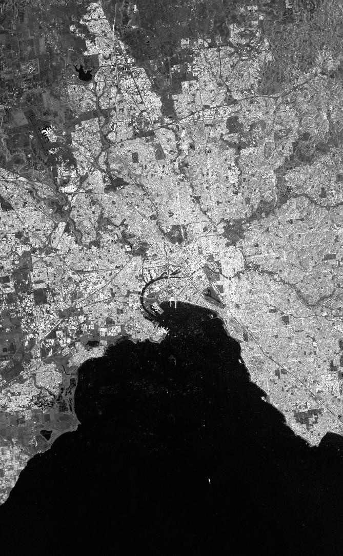
5 SAR Examples: Complex atmospheric features on the sea surface SAR Examples: Complex atmospheric features on the sea surface TerraSAR-X South Australia TerraSAR-X South Australia SAR Examples: Complex atmospheric features on the sea surface SAR Examples: Radar image of harbor areas: Melbourne TerraSAR-X TerraSAR-X Tasmanian Sea North 19 20
 Radars at Grazing")
. The measurement is caused by the backscattering of the electromagnetic waves due to the roughness of the sea surface.")


6 SAR Examples: Radar image of harbor areas: Sydney TerraSAR-X Multi-temporal image Resolution: ~ 1 m Radars at Grazing Incidence (I) High Frequency Radars: It measure currents as well as wave spectra EuroROSE Research Project: Gijón Experiment WERA: Receiving Antenna Radars at Grazing Incidence (II) Radars at Grazing Incidence (III) Microwave Radars at Grazing Incidence (II): Microwave Radars at Grazing Incidence (I): They normally work at X-Band (electromagnetic wave length of 3cm). The measurement is caused by the backscattering of the electromagnetic waves due to the roughness of the sea surface. A minimum wind speed is needed to obtain a reliable signal for sea state detection. They can operate in vertical (VV) or horizontal (HH) polarization. These systems are easy to be mounted on moving ships, as well as on- and offshore platforms. Most of these systems permit to obtain temporal sequences of radar images using consecutive antenna rotations. Evolution of wave fields on space and time can be derived. Types: Doppler Radars: The measurement is closely related to the pattern of the water particle velocities. Coherent Radars: They measure both amplitude and phase of the backscattered signal. Marine Radars: Typical radar systems used on every moving vessel and maritime traffic control tower

.")
7 Marine Radar Marine Radar Imagery (I) Common radar systems mounted on Moving ships. Off and on shore platforms. Marine traffic control towers. It works on X Band. HH polarisation. Incoherent radar systems. Under various conditions, signatures of the sea surface are visible in marine X-Band radar images. These signatures are known as sea clutter, which is undesirable for navigation purposes. Sea clutter is caused by the backscatter of the transmitted electromagnetic waves from the short sea surface ripples in the range of the electromagnetic wavelength (e.g. ~3 cm). Longer waves like swell and wind sea become visible as they modulate the backscatter signal. It permits to scan consecutive images of the sea surface Marine Radar Imagery (II) WaMoS System Some effects are responsible of the radar imagery at grazing incidence and HH polarisation: Shadowing WaMoS II (Wave Monitoring System) Originally developed by the German GKSS Research Centre Nowadays is commercialised Tilt modulation Hydrodynamic modulation Orbital modulation Wind and wave direction... and others (wave breaking, crests, foam, etc.). The radar imaging mechanisms for marine radar are not yet fully understood. Internet/LAN 27 28
 Late 1950 s: First experiences onboard ships. 1984: First estimation of the directional spectrum and surface current.")
8 WaMoS System Using consecutive antenna rotations, a data set composed of time series radar images is obtained Example of sea clutter time series 4 km Analysis of Wave Fields by using X-Band Marine Radar Brief History of the Analysis of Ocean Waves with Marine Radars (I) Late 1950 s: First experiences onboard ships. 1984: First estimation of the directional spectrum and surface current : Operational system: WaMoS-II 1997: Improvement of the inversion modelling technique: Part I: The marine radar as a remote sensing tool for wave analysis Estimation of the modulation transfer function. Obtention of the higher harmonics. Improvement of the current fit. 1998: Estimation of the significant wave height. Full operational and commercial system: WaMoS-II

9 Brief History of the Analysis of Ocean Waves with Marine Radars (II) Marine Radar Recent developments: Bathymetry estimation. High resolution currents for coastal areas. Local studies of wave fields for variable bathimetry conditions: coastal areas. Estimation of the sea surface: Analysis of individual waves in space and time. Wave groupiness studies in 3D: wave energy propagation. Internal wave detection for harbour locations. Wave breaking. Operational Under research Ordinary marine radars scan the sea water surface at grazing incidence. These systems can be used as a microwave remote sensing tool. Using temporal sequences of sea clutter images it is possible to derive information about wave periods, lengths, and propagation directions. Due to the marine radar response to the sea surface is not calibrated, wave height estimation cannot obtained in a simple way as other wave field parameters. This works deals with a method to estimate ocean wave heights from marine radar data sets. The method is based on the signal-noise ratio due to the speckle background noise due to the sea surface roughness Marine Radar Marine Radar Geometry X-band marine radars operate at grazing incidence: Higher angles of incidence. Typical radar features for wave measurement Feature Value Improvement Antenna Length 6 feet Larger Band X - Output Power 20 kw Higher Azimuthal Resolution Antenna Rotation Period Pulse Repetition Frequency 1 degree Smaller 2.5 s Faster Rotation 2 khz - Sampling Frequency 16 MHz Higher 35 36


10 Examples of Radar Images of The Sea Surface Wave Field Detection Using Marine Radars 1. Selection of a Rectangular Area. 2. Temporal Sequence Extraction. 3. Computation of the Image Spectrum. Typical rectangle size: 2 x 1 km 2 ~ The wave field within the rectangular area should be statistically homogeneous Deep Waters: Measurement on board a moving vessel Statistically homogeneous wave field Shallow Waters: Measurement from a on-shore radar station Statistically inhomogeneous wave field due to the variable bottom topography Wave Refraction Digitized Radar Image 3D FFT Image Spectrum Image Spectrum The radar image is a consecuence of the radar backscattering mechanisms due to the sea surface, rather than an image of the wave field. The 3D FFT of the radar image time series is not an estimation of the wave spectrum, but an estimation of the spectrum of the different radar modulations that performs the image. Part II: The image Spectrum for that reason, the spectrum of the temporal sequence of sea surface radar images is called image spectrum. Inverse modelling techniques are applied to estimate the wave spectrum. Prior to define the steps of the inversion modelling techniques it is necessary to understand the structure of the image spectrum


11 Image Spectrum Structure of the Image Spectrum Wind To define a proper method to estimate the wave spectra it is necessary to understand the structure of the image spectrum. The image spectrum structure implies to link the different hydrodynamic and electromagnetic phenomena responsible of the radar imagery with the different Wave Field Radar Imagery Mechanisms Radar Image (sea clutter) contributions to the image spectrum in the spectral domain of wave numbers and frequencies. 3D FFT 3D FFT Some of these phenomena are still not well understood, mainly because of the grazing incidence and HH polarisation conditions. Wave Spectrum Inversion Modelling Image Spectrum Theoretical results predict that the intensity of the radar image due to the se surface must be weaker than what it is obtained in Nature. This fact implies that ordinary marine radars are a reliable remote sensing tool for oceanic purposes Structure of the Image Spectrum Structure of the Image Spectrum Contributions to the image spectrum: Quasi-estatic patterns due to the constant dependence of radar imagery: Radar equation: P r = P tg t A r F 4 (4 2 )R 4 Background noise due to the sea surface roughness (induced to the local wind). Wave components (within the dispersion shell). 2D transect of a image spectrum measured in the Northern Coast of Spain. Swell conditions Radar Image Time Series 3D DFT Higher harmonics (due to the shadowing and nonlinear wave features). Subharmonic ( group line ): due to the shadowing, nonlinear wave features, wave breaking, etc
 Group Line Group")
 (Radar Equation) Background Noise (speckle) First Harmonic 45 46 Structure of the Image")

12 Structure of the Image Spectrum Structure of the Image Spectrum: Alisaing Effect First Harmonic Including the domain of negative frequencies Dispersion Relation Aliased Wave Components Wave Components (dispersion relation) Group Line Group Line Static pattern First Harmonic (non linear radar imaging) Group Line (non linear wave components) Dispersion Relation Static Patterns (ω <<) (Radar Equation) Background Noise (speckle) First Harmonic Structure of the Image Spectrum Structure of the Image Spectrum Higher harmonics Higher harmonics Caused by nonlinear radar imaging process due to shadowing. Weak nonlinearities of the wave field presents spectral components in the same location of the spectral domain
 Due to shadowing effects First Harmonic s k k =(p + 1) g p +1 tanh p +1 d + k U Harmonics Dispersion Relation 49 50 Structure of the Image Spectrum Structure")
13 Structure of the Image Spectrum Structure of the Image Spectrum Equation of the higher harmonics Harmonics of the dispersion relation: 7 (p + 1) k 7 k (p + 1) p =0, 1,... Fundamental Mode (dispersion relation) Due to shadowing effects First Harmonic s k k =(p + 1) g p +1 tanh p +1 d + k U Harmonics Dispersion Relation Structure of the Image Spectrum Structure of the Image Spectrum Background noise (BGN): It is possible to identify nonlinearities in an n-dimensional spectrum Higher harmonics (nonlinear contribution). Due to the sea surface roughness induced by the local wind. BGN permits to derive the Significant Wave Height from the signal to noise ratio. Higher order (summation) of spectral components. Due to nonlinear radar imaging effects (shadowing). Due to weak nonlinearities of the wave field (Stokes waves). How to separate Them? Signal: Energy of the wave field components. Noise: Energy of the BGN components. Research work has been started on that direction 51 52


14 Structure of the Image Spectrum Structure of the Image Spectrum Spectral noise: Related to the speckle noise in the radar image. Speckle is directly related to the sea surface roughness. Roughness is caused by the local wind. Spectral noise: Independent of the frequency. Normalised BGN Spectrum Angular Frequency ω [rad/s] A parameterisation of the spectral noise would permit a better understanding of the marine radar imaging mechanisms. The existence of the spectral noise permits to estimate Hs Inversion Modelling method Using consecutive antenna rotations, a data set composed of time series radar images is obtained. An inversion modelling method is applied to the image spectrum to estimate the wave spectrum. Hydrodynamic assumptions are considered. Part III: Wave field analysis 55 56


15 Inversion Modelling method Basics of the wave field measurement by using marine radars Steps of the inversion modelling technique: Current fit. Inversion Modelling method Sea Clutter Time Series 3D FT 3D Image Spectrum Additional option: water depth fit. In addition the water depth could be estimated as well. Phases Surface Current Inversion Modelling Technique 3D pass-band filtering of the wave components within the dispersion shell. Application of an empirical Modulation Transfer Function to correct the wave energy due to radar imaging mechanisms. Scale of the wave spectrum from the Signal to Noise ratio. Derivation of sea state parameters: Sea Surface Estimation 3D Inverse FT Wave Spectrum Directional wave spectrum. Wave heights, periods, propagation directions, etc The basics of the inversion modelling technique assume that ocean waves are dispersive This fact permits to obtain estimations of Sea surface current (current of encounter) U =(U x,u y ) Water depth Inversion Modelling method d Wave spectrum depending on Wave number and frequency Wave number = (k) = p gk tanh(kd)+k U F (2) + (k) F (3) (k, ) Frequency and wave propagation direction E(, ) Only the current that affect the wave field can be measured Inversion Modelling method The inversion modelling technique is based on the hydrodynamic properties of ocean waves Ocean waves are dispersive and they follow a dispersion relation. The inversion model uses Theoretical assumptions: 3D band-pass filter within the dispersion shell. Empirical corrections: transfer function depending on the wave number to correct the wave spectrum estimation. Frequency S( ) 59 60
 Tidal periodicity")


16 Current Fit Example of sea surface current estimation (North Sea) Tidal periodicity observed Current Speed FINO 1 Research Platform Wave Number Spectrum Example of a bimodal sea state measured by a WaMoS-II system Current Direction Frequency Spectrum Comparison with a directional buoy (Bay of Biscay) Spectral Parameters Comparison with a directional buoy (Bay of Biscay) Frequency Spectrum From the wave number spectrum Frequency Spectrum From the frequencydirection spectrum 63 64
.")
. A set of sensors are deployed in the field area: Wave buoy (used as reference sensor).")

.")
17 Significant Wave Height Derived from the signal to noise ratio. Significant Wave Height Measurement at the Ekofisk Oill Platform (ConocoPhillips, Norway). a previous calibration campaign is needed Significant Wave Height Significant Wave Height EKOFISK Oil and Gas Platform (ConocoPhillips). A set of sensors are deployed in the field area: Wave buoy (used as reference sensor). Neural Network-based methods seems to be a reliable technique to derive SWH. UAH in collaboration with OceanWaveS GmbH is working on this way. 4-array of wave lasers. WaMoS Station. SNR The standard Hs estimation method for marine radar is more accurate than the wave lasers for Hs > 2.5 m (Harald Krogstad*, personal communication). Wave Lengths Wave Periods Neural Network (MLP) Significant Wave Height For Hs < 2.5 m the Hs estimation should be improved: Cases of swell or low winds. Other sea state parameters * Norwegian University of Science and Technology, Trondheim, Norway 67 68
 = 0.926 New Developements 69 70 Detection of Individual Waves The method assumes that the shadowing is the dominant modulation mechanism.")

18 Significant Wave Height Results from EKOFISK. Buoy vs. WaMoS (standard) r = r(hs < 2.5m) = r(hs > 2.5m) = Buoy vs. WaMoS (NN) r = r(hs < 2.5m) = r(hs > 2.5m) = New Developements Detection of Individual Waves The method assumes that the shadowing is the dominant modulation mechanism. Detection of Individual Waves Estimation of individual waves The main imagery mechanism for marine radar (e.g. grazing incidence) is shadowing. Sea Clutter Time Series 3D FT 3D Image Spectrum This fact permits to estimate the sea surface for individual wave analysis. Sea Clutter Time Series Sea Surface Inversion Phases Surface Current Inversion Modelling Technique Sea Surface Estimation 3D Inverse FT Wave Spectrum 71 72
 Estimation of the 3D envelope through the 3D Riesz transform Riesz transform is a n-dimensinal generalization of the Hilbert transform Before only wave")


19 Detection of Individual Waves Wave Group Analysis From the wave field elevation kinematic and dynamic features can be derived Wave group analysis from the envelope in 3D (space + time) Estimation of the 3D envelope through the 3D Riesz transform Riesz transform is a n-dimensinal generalization of the Hilbert transform Before only wave grouping information from buoy records could be derived. Analysis of wave energy propagation: Kinetic wave energy per unit of area. Potential wave energy per unit of area. Energy flux. Orbital velocity components (u, v, w): Coastal morphodynamics Analysis of on and off shore marine structures Wave Field Riesz Transform Envelope Wave Group Analysis Wave Group Analysis Wave fields present groups or packages of high waves travelling together. 3D Spectrum of the wave envelope. Groups are responsible of the propagation of the wave energy. Sea Surface 3D Wave Envelope Group Train components (responsible of the energy propagation) Pulse Train components (zero mean) 75 76
 Analysis of the phase speed to estimate wave breaking.")
 Velocity Potential (x, y, t) Orbital velocity components u(x, y, t) v(x, y,")


20 Orbital Velocity Components Orbital Velocity Components Orbital velocity components (u, v, w) Orbital velocity components (u, v, w) Analysis of the phase speed to estimate wave breaking. Stability of marine systems. Wave field (x, y, t) Velocity Potential (x, y, t) Orbital velocity components u(x, y, t) v(x, y, t) w(x, y, t) u-w along the X- axis. Orbital Velocity Components Estimation of bottom topography for coastal areas. Radar derived bathimetry Paul Bell*, 2010, Submerged Dunes and Breakwater Embayments Mapped Using Wave Inversions of Shore-Mounted Marine X-Band Radar Data. IGARSS 2010, Honolulu. Conventional survey (Gridded), Carried out by University of East Anglia, UK Radar Derived Bathymetry * Proudman Oceanographic Laboratory. National Oceanography Centre. UK 79 80


 J.")
 http://www.youtube.com/watch?")


21 Wind field estimation. J. Horstmann*, M. Coffin*, and R. Vicen-Bueno**, 2010, A Marine Radar Based Surface Monitoring System. IGARSS 2010, Honolulu. Internal waves induced by a moving vessel J. Horstmann*, M. Coffin*, and R. Vicen-Bueno**, 2010, A Marine Radar Based Surface Monitoring System. IGARSS 2010, Honolulu. Wind gusts for wind retrieval * NATO Undersea Research Center. La Spezia, Italy * University of Alcalá, Spain * NATO Undersea Research Center. La Spezia, Italy * University of Alcalá, Spain Internal Wave Detection in Isola Palmaria (Italy) J. Horstmann, R. Carrasco, C. Lidó (NURC) Wave breaking in shallow waters Wave breaking features change the roughness of the sea surface. WaMoS measurement from the German island of Sylt


22 The radar signal is caused by the electromagnetic backscattering phenomenon due to the sea surface roughness. Marine radars can detect sea surface features, such as Wave field parameters including individual waves. Surface currents. Local wind fields. Summary and Outlook Other effects related to the sea roughness. Hs measurements need a previous calibration campaign. Recent improvement permits to obtain Hs even for those cases where the wind speed is lower. The standard analysis of radar images is based on the assumption of spatial homogeneity This is valid for deep or constant water depth conditions. For coastal applications new techniques have to be developed/applied. Recent results permit to estimate individual wave properties. Sea surface estimation. Summary (2) Wave grouping analysis. Orbital velocities Thanks 87
SATELLITE OCEANOGRAPHY
 SATELLITE OCEANOGRAPHY An Introduction for Oceanographers and Remote-sensing Scientists I. S. Robinson Lecturer in Physical Oceanography Department of Oceanography University of Southampton JOHN WILEY
Microwave Remote Sensing (1)
") Microwave Remote Sensing (1) Microwave sensing encompasses both active and passive forms of remote sensing. The microwave portion of the spectrum covers the range from approximately 1cm to 1m in wavelength.
Microwave Remote Sensing (1) Microwave sensing encompasses both active and passive forms of remote sensing. The microwave portion of the spectrum covers the range from approximately 1cm to 1m in wavelength.
OMAE99/OSU-3063 ESTIMATION OF THE SIGNIFICANT WAVE HEIGHT WITH X-BAND NAUTICAL RADARS ABSTRACT 1 INTRODUCTION. 1 Copyright (C) 1999 by ASME
 1999 by ASME") OMAE99/OSU-3063 ESTIMATION OF THE SIGNIFICANT WAVE HEIGHT WITH X-BAND NAUTICAL RADARS JOSti CARLOS NIETO BORGE CLIMA MARiTIMO, PUERTOS DEL ESTADO MADRID. SPAIN KATRIN HESSNER OCEAN SENSWARE, GKSS TECHNOLOGIEZENTRUM
OMAE99/OSU-3063 ESTIMATION OF THE SIGNIFICANT WAVE HEIGHT WITH X-BAND NAUTICAL RADARS JOSti CARLOS NIETO BORGE CLIMA MARiTIMO, PUERTOS DEL ESTADO MADRID. SPAIN KATRIN HESSNER OCEAN SENSWARE, GKSS TECHNOLOGIEZENTRUM
X-Band radar as a tool to determine spectral and single wave properties
 X-Band radar as a tool to determine spectral and single wave properties Konstanze Reichert November 2004 History of WaMoS II 25 Years of progress Application of WaMoS II for offshore and shipping WaMoS
Nearshore Applications of Marine Radar
 Nearshore Applications of Marine Radar JD Lentine 15 June 2006 A project in fulfillment of the Master s of Science in Civil Engineering, Oregon State University Table of Contents 1. Introduction Research
Co-ReSyF RA lecture: Vessel detection and oil spill detection
 This project has received funding from the European Union s Horizon 2020 Research and Innovation Programme under grant agreement no 687289 Co-ReSyF RA lecture: Vessel detection and oil spill detection
Remote Sensing. Ch. 3 Microwaves (Part 1 of 2)
") Remote Sensing Ch. 3 Microwaves (Part 1 of 2) 3.1 Introduction 3.2 Radar Basics 3.3 Viewing Geometry and Spatial Resolution 3.4 Radar Image Distortions 3.1 Introduction Microwave (1cm to 1m in wavelength)
Remote Sensing Ch. 3 Microwaves (Part 1 of 2) 3.1 Introduction 3.2 Radar Basics 3.3 Viewing Geometry and Spatial Resolution 3.4 Radar Image Distortions 3.1 Introduction Microwave (1cm to 1m in wavelength)
Remote Sensing: John Wilkin IMCS Building Room 211C ext 251. Active microwave systems (1) Satellite Altimetry
 Satellite Altimetry") Remote Sensing: John Wilkin wilkin@marine.rutgers.edu IMCS Building Room 211C 732-932-6555 ext 251 Active microwave systems (1) Satellite Altimetry Active microwave instruments Scatterometer (scattering
Remote Sensing: John Wilkin wilkin@marine.rutgers.edu IMCS Building Room 211C 732-932-6555 ext 251 Active microwave systems (1) Satellite Altimetry Active microwave instruments Scatterometer (scattering
Use of X-band marine radars as a remote sensing system to survey wind-generated waves
 Coastal Processes III 27 Use of X-band marine radars as a remote sensing system to survey wind-generated waves J. C. Nieto Borge Universidad de Alcalá, Spain Abstract This work deals with the use of conventionalx-band
ACTIVE SENSORS RADAR
 ACTIVE SENSORS RADAR RADAR LiDAR: Light Detection And Ranging RADAR: RAdio Detection And Ranging SONAR: SOund Navigation And Ranging Used to image the ocean floor (produce bathymetic maps) and detect objects
Wave Sensing Radar and Wave Reconstruction
 Applied Physical Sciences Corp. 475 Bridge Street, Suite 100, Groton, CT 06340 (860) 448-3253 www.aphysci.com Wave Sensing Radar and Wave Reconstruction Gordon Farquharson, John Mower, and Bill Plant (APL-UW)
Remote Sensing: John Wilkin IMCS Building Room 211C ext 251. Active microwave systems (1) Satellite Altimetry
 Satellite Altimetry") Remote Sensing: John Wilkin wilkin@marine.rutgers.edu IMCS Building Room 211C 732-932-6555 ext 251 Active microwave systems (1) Satellite Altimetry Active microwave instruments Scatterometer (scattering
Remote Sensing: John Wilkin wilkin@marine.rutgers.edu IMCS Building Room 211C 732-932-6555 ext 251 Active microwave systems (1) Satellite Altimetry Active microwave instruments Scatterometer (scattering
EE 529 Remote Sensing Techniques. Introduction
 EE 529 Remote Sensing Techniques Introduction Course Contents Radar Imaging Sensors Imaging Sensors Imaging Algorithms Imaging Algorithms Course Contents (Cont( Cont d) Simulated Raw Data y r Processing
Active and Passive Microwave Remote Sensing
 Active and Passive Microwave Remote Sensing Passive remote sensing system record EMR that was reflected (e.g., blue, green, red, and near IR) or emitted (e.g., thermal IR) from the surface of the Earth.
Microwave Remote Sensing
 Provide copy on a CD of the UCAR multi-media tutorial to all in class. Assign Ch-7 and Ch-9 (for two weeks) as reading material for this class. HW#4 (Due in two weeks) Problems 1,2,3 and 4 (Chapter 7)
Active microwave systems (1) Satellite Altimetry
 Satellite Altimetry") Remote Sensing: John Wilkin Active microwave systems (1) Satellite Altimetry jwilkin@rutgers.edu IMCS Building Room 214C 732-932-6555 ext 251 Active microwave instruments Scatterometer (scattering from
Remote Sensing: John Wilkin Active microwave systems (1) Satellite Altimetry jwilkin@rutgers.edu IMCS Building Room 214C 732-932-6555 ext 251 Active microwave instruments Scatterometer (scattering from
Introduction Active microwave Radar
 RADAR Imaging Introduction 2 Introduction Active microwave Radar Passive remote sensing systems record electromagnetic energy that was reflected or emitted from the surface of the Earth. There are also
Estimation of Ocean Current Velocity near Incheon using Radarsat-1 SAR and HF-radar Data
 Korean Journal of Remote Sensing, Vol.23, No.5, 2007, pp.421~430 Estimation of Ocean Current Velocity near Incheon using Radarsat-1 SAR and HF-radar Data Moon-Kyung Kang and Hoonyol Lee Department of Geophysics,
APPLICATION OF OCEAN RADAR ON THE BALTIC, FEATURES AND LIMITATIONS
 APPLICATION OF OCEAN RADAR ON THE BALTIC, FEATURES AND LIMITATIONS Thomas Helzel, Matthias Kniephoff, Leif Petersen, Markus Valentin Helzel Messtechnik GmbH e-mail: helzel@helzel.com Presentation at Hydro
WAMOS II: A RADAR BASED WAVE AND CURRENT MONITORING SYSTEM
 resented at ISOE '99 Brest May 999 - roceedings Vol. 3 WAMOS II: A RADAR BASED WAVE AND CURRENT MONITORING SYSTEM K. Reichert K. Hessner J. C. Nieto Borge 2 J. Dittmer 3 Ocean SensWare GKSS Technologiezentrum
RADAR DEVELOPMENT BASIC CONCEPT OF RADAR WAS DEMONSTRATED BY HEINRICH. HERTZ VERIFIED THE MAXWELL RADAR.
 1 RADAR WHAT IS RADAR? RADAR (RADIO DETECTION AND RANGING) IS A WAY TO DETECT AND STUDY FAR OFF TARGETS BY TRANSMITTING A RADIO PULSE IN THE DIRECTION OF THE TARGET AND OBSERVING THE REFLECTION OF THE
Coherent Marine Radar. Measurements of Ocean Wave Spectra and Surface Currents
 Measurements of Ocean Wave Spectra and Surface Currents Dennis Trizna Imaging Science Research, Inc. dennis @ isr-sensing.com Presentation Outline: Introduction: Standard Marine Radar vs. Single Image
Synthetic aperture RADAR (SAR) principles/instruments October 31, 2018
 principles/instruments October 31, 2018") GEOL 1460/2461 Ramsey Introduction to Remote Sensing Fall, 2018 Synthetic aperture RADAR (SAR) principles/instruments October 31, 2018 I. Reminder: Upcoming Dates lab #2 reports due by the start of next
GEOL 1460/2461 Ramsey Introduction to Remote Sensing Fall, 2018 Synthetic aperture RADAR (SAR) principles/instruments October 31, 2018 I. Reminder: Upcoming Dates lab #2 reports due by the start of next
GNSS Ocean Reflected Signals
 GNSS Ocean Reflected Signals Per Høeg DTU Space Technical University of Denmark Content Experimental setup Instrument Measurements and observations Spectral characteristics, analysis and retrieval method
GNSS Reflectometry and Passive Radar at DLR
 ACES and FUTURE GNSS-Based EARTH OBSERVATION and NAVIGATION 26./27. May 2008, TU München Dr. Thomas Börner, Microwaves and Radar Institute, DLR Overview GNSS Reflectometry a joined proposal of DLR and
The Delay-Doppler Altimeter
 Briefing for the Coastal Altimetry Workshop The Delay-Doppler Altimeter R. K. Raney Johns Hopkins University Applied Physics Laboratory 05-07 February 2008 1 What is a Delay-Doppler altimeter? Precision
C three decadesz'other reviews serve that purpose (e.g., Barrick, 1978;
 STATUS OF HF RADARS FOR WAVE-HEIGHT DIRECTIONAL SPECTRAL MEASUREMENTS - Donald E. Barrick 1 Introduction SThis manuscript is a concise review of the status of high-frequency (HF) radars for measuring various
High Frequency Acoustic Channel Characterization for Propagation and Ambient Noise
 High Frequency Acoustic Channel Characterization for Propagation and Ambient Noise Martin Siderius Portland State University, ECE Department 1900 SW 4 th Ave., Portland, OR 97201 phone: (503) 725-3223
RADAR REMOTE SENSING
 RADAR REMOTE SENSING Jan G.P.W. Clevers & Steven M. de Jong Chapter 8 of L&K 1 Wave theory for the EMS: Section 1.2 of L&K E = electrical field M = magnetic field c = speed of light : propagation direction
Active and Passive Microwave Remote Sensing
 Active and Passive Microwave Remote Sensing Passive remote sensing system record EMR that was reflected (e.g., blue, green, red, and near IR) or emitted (e.g., thermal IR) from the surface of the Earth.
Concept Design of Space-Borne Radars for Tsunami Detection
 Concept Design of Space-Borne Radars for Tsunami Detection DLR German Aerospace Agency +Microwaves and Radar Institute *Remote Sensing Institute +Michele Galletti +Gerhard Krieger +Nicolas Marquart +Thomas
RADAR (RAdio Detection And Ranging)
") RADAR (RAdio Detection And Ranging) CLASSIFICATION OF NONPHOTOGRAPHIC REMOTE SENSORS PASSIVE ACTIVE DIGITAL CAMERA THERMAL (e.g. TIMS) VIDEO CAMERA MULTI- SPECTRAL SCANNERS VISIBLE & NIR MICROWAVE Real
RADAR (RAdio Detection And Ranging) CLASSIFICATION OF NONPHOTOGRAPHIC REMOTE SENSORS PASSIVE ACTIVE DIGITAL CAMERA THERMAL (e.g. TIMS) VIDEO CAMERA MULTI- SPECTRAL SCANNERS VISIBLE & NIR MICROWAVE Real
Active microwave systems (2) Satellite Altimetry * range data processing * applications
 Satellite Altimetry * range data processing * applications") Remote Sensing: John Wilkin wilkin@marine.rutgers.edu IMCS Building Room 211C 732-932-6555 ext 251 Active microwave systems (2) Satellite Altimetry * range data processing * applications Satellite Altimeters
Remote Sensing: John Wilkin wilkin@marine.rutgers.edu IMCS Building Room 211C 732-932-6555 ext 251 Active microwave systems (2) Satellite Altimetry * range data processing * applications Satellite Altimeters
Introduction to Microwave Remote Sensing
 Introduction to Microwave Remote Sensing lain H. Woodhouse The University of Edinburgh Scotland Taylor & Francis Taylor & Francis Group Boca Raton London New York A CRC title, part of the Taylor & Francis
Radar Reprinted from "Waves in Motion", McGourty and Rideout, RET 2005
 Radar Reprinted from "Waves in Motion", McGourty and Rideout, RET 2005 What is Radar? RADAR (Radio Detection And Ranging) is a way to detect and study far off targets by transmitting a radio pulse in the
Wave Height Measurement Using a Short-range FMCW Radar for Unmanned Surface Craft
 Wave Height Measurement Using a Short-range FMCW Radar for Unmanned Surface Craft Jian Cui*, Ralf Bachmayer*, Weimin Huang*, Brad deyoung** *Faculty of Engineering and Applied Science, Memorial University
ATS 351 Lecture 9 Radar
 ATS 351 Lecture 9 Radar Radio Waves Electromagnetic Waves Consist of an electric field and a magnetic field Polarization: describes the orientation of the electric field. 1 Remote Sensing Passive vs Active
746A27 Remote Sensing and GIS
 746A27 Remote Sensing and GIS Lecture 1 Concepts of remote sensing and Basic principle of Photogrammetry Chandan Roy Guest Lecturer Department of Computer and Information Science Linköping University What
Prototype Software-based Receiver for Remote Sensing using Reflected GPS Signals. Dinesh Manandhar The University of Tokyo
 Prototype Software-based Receiver for Remote Sensing using Reflected GPS Signals Dinesh Manandhar The University of Tokyo dinesh@qzss.org 1 Contents Background Remote Sensing Capability System Architecture
CODAR. Ben Kravitz September 29, 2009
 CODAR Ben Kravitz September 29, 2009 Outline What is CODAR? Doppler shift Bragg scatter How CODAR works What CODAR can tell us What is CODAR? Coastal Ocean Dynamics Application Radar Land-based HF radar
Acknowledgment. Process of Atmospheric Radiation. Atmospheric Transmittance. Microwaves used by Radar GMAT Principles of Remote Sensing
 GMAT 9600 Principles of Remote Sensing Week 4 Radar Background & Surface Interactions Acknowledgment Mike Chang Natural Resources Canada Process of Atmospheric Radiation Dr. Linlin Ge and Prof Bruce Forster
CYGNSS Wind Retrieval Performance
 International Ocean Vector Wind Science Team Meeting Kailua-Kona, Hawaii USA 6-8 May 2013 CYGNSS Wind Retrieval Performance Chris Ruf (1), Maria-Paola Clarizia (1,2), Andrew O Brien (3), Joel Johnson (3),
Synthetic Aperture Radar
 Synthetic Aperture Radar Picture 1: Radar silhouette of a ship, produced with the ISAR-Processor of the Ocean Master A Synthetic Aperture Radar (SAR), or SAR, is a coherent mostly airborne or spaceborne
10 Radar Imaging Radar Imaging
 10 Radar Imaging Active sensors provide their own source of energy to illuminate the target. Active sensors are generally divided into two distinct categories: imaging and non-imaging. The most common
Specificities of Near Nadir Ka-band Interferometric SAR Imagery
 Specificities of Near Nadir Ka-band Interferometric SAR Imagery Roger Fjørtoft, Alain Mallet, Nadine Pourthie, Jean-Marc Gaudin, Christine Lion Centre National d Etudes Spatiales (CNES), France Fifamé
China. France Oceanography S A T. Overview of the near-real time wave products of the CFOSAT mission. e l l i t e
 China Overview of the near-real time wave products of the CFOSAT mission C. Tison (1), D. Hauser (2), S. Guibert (1), T. Amiot (1), L. Aouf (3), J.M. Lefèvre (3), B. Chapron (5), N. Corcoral (1), P. Castillan
MULTI-TEMPORAL SATELLITE IMAGES WITH BATHYMETRY CORRECTION FOR MAPPING AND ASSESSING SEAGRASS BED CHANGES IN DONGSHA ATOLL
 MULTI-TEMPORAL SATELLITE IMAGES WITH BATHYMETRY CORRECTION FOR MAPPING AND ASSESSING SEAGRASS BED CHANGES IN DONGSHA ATOLL Chih -Yuan Lin and Hsuan Ren Center for Space and Remote Sensing Research, National
Assessment of HF Radar for Significant Wave Height Determination. Desmond Power VP, Remote Sensing, C-CORE
 Assessment of HF Radar for Significant Wave Height Determination Desmond Power VP, Remote Sensing, C-CORE Study Rationale Agenda Technology Overview Technology Assessment for CNLOPB Proposed Go Forward
Day One 12/07/ Introduction to Co-ReSyF Miguel Terra-Homem. Building on the SenSyF project.
 Day One 12/07/2017 1.1. Introduction to Co-ReSyF Miguel Terra-Homem Building on the SenSyF project. Satellite data access is normally accessible through each mission. Each mission then has heterogeneous
Observing Dry-Fallen Intertidal Flats in the German Bight Using ALOS PALSAR Together With Other Remote Sensing Sensors
 Observing Dry-Fallen Intertidal Flats in the German Bight Using ALOS PALSAR Together With Other Remote Sensing Sensors Martin Gade, Institut für Meereskunde & Kerstin Stelzer Brockmann Consult Outline
DOPPLER RADAR. Doppler Velocities - The Doppler shift. if φ 0 = 0, then φ = 4π. where
 Q: How does the radar get velocity information on the particles? DOPPLER RADAR Doppler Velocities - The Doppler shift Simple Example: Measures a Doppler shift - change in frequency of radiation due to
Copernicus Introduction Lisbon, Portugal 13 th & 14 th February 2014
 Copernicus Introduction Lisbon, Portugal 13 th & 14 th February 2014 Contents Introduction GMES Copernicus Six thematic areas Infrastructure Space data An introduction to Remote Sensing In-situ data Applications
ESA Radar Remote Sensing Course ESA Radar Remote Sensing Course Radar, SAR, InSAR; a first introduction
 Radar, SAR, InSAR; a first introduction Ramon Hanssen Delft University of Technology The Netherlands r.f.hanssen@tudelft.nl Charles University in Prague Contents Radar background and fundamentals Imaging
Coherent Marine Radar Measurements of Ocean Surface Currents and Directional Wave Spectra
 Coherent Marine Radar Measurements of Ocean Surface Currents and Directional Wave Spectra Dennis B Trizna Imaging Science Research, Inc. 6103B Virgo Court Burke, VA 22015 USA Abstract- A coherent marine
Rec. ITU-R P RECOMMENDATION ITU-R P *
 Rec. ITU-R P.682-1 1 RECOMMENDATION ITU-R P.682-1 * PROPAGATION DATA REQUIRED FOR THE DESIGN OF EARTH-SPACE AERONAUTICAL MOBILE TELECOMMUNICATION SYSTEMS (Question ITU-R 207/3) Rec. 682-1 (1990-1992) The
SHIP DETECTION AND SEA CLUTTER CHARACTERISATION USING X&L BAND FULL-POLARIMETRIC AIRBORNE SAR DATA
 SHIP DETECTION AND SEA CLUTTER CHARACTERISATION USING X&L BAND FULL-POLARIMETRIC AIRBORNE SAR DATA S. Angelliaume, Ph. Martineau (ONERA) Ph. Durand, T. Cussac (CNES) Context CNES/ONERA study of Space System
Time Reversal Ocean Acoustic Experiments At 3.5 khz: Applications To Active Sonar And Undersea Communications
 Time Reversal Ocean Acoustic Experiments At 3.5 khz: Applications To Active Sonar And Undersea Communications Heechun Song, P. Roux, T. Akal, G. Edelmann, W. Higley, W.S. Hodgkiss, W.A. Kuperman, K. Raghukumar,
On Marine Radar Near- Surface Current Mapping
 On Marine Radar Near- Surface Current Mapping Björn Lund 1, Brian Haus 1, Jochen Horstmann 2, Hans Graber 1, and CARTHE team 1 University of Miami, 2 Helmholtz Zentrum Geesthacht LASER Experiment Sources:
Analysis of South China Sea Shelf and Basin Acoustic Transmission Data
 DISTRIBUTION STATEMENT A: Distribution approved for public release; distribution is unlimited. Analysis of South China Sea Shelf and Basin Acoustic Transmission Data Ching-Sang Chiu Department of Oceanography
CEGEG046 / GEOG3051 Principles & Practice of Remote Sensing (PPRS) 8: RADAR 1
 8: RADAR 1") CEGEG046 / GEOG3051 Principles & Practice of Remote Sensing (PPRS) 8: RADAR 1 Dr. Mathias (Mat) Disney UCL Geography Office: 113, Pearson Building Tel: 7670 05921 Email: mdisney@ucl.geog.ac.uk www.geog.ucl.ac.uk/~mdisney
CEGEG046 / GEOG3051 Principles & Practice of Remote Sensing (PPRS) 8: RADAR 1 Dr. Mathias (Mat) Disney UCL Geography Office: 113, Pearson Building Tel: 7670 05921 Email: mdisney@ucl.geog.ac.uk www.geog.ucl.ac.uk/~mdisney
MONITORING SEA LEVEL USING GPS
 38 MONITORING SEA LEVEL USING GPS Hasanuddin Z. Abidin* Abstract GPS (Global Positioning System) is a passive, all-weather satellite-based navigation and positioning system, which is designed to provide
Remote Sensing 1 Principles of visible and radar remote sensing & sensors
 Remote Sensing 1 Principles of visible and radar remote sensing & sensors Nick Barrand School of Geography, Earth & Environmental Sciences University of Birmingham, UK Field glaciologist collecting data
CHAPTER 1 INTRODUCTION
 1 CHAPTER 1 INTRODUCTION In maritime surveillance, radar echoes which clutter the radar and challenge small target detection. Clutter is unwanted echoes that can make target detection of wanted targets
Radar and Satellite Remote Sensing. Chris Allen, Associate Director Technology Center for Remote Sensing of Ice Sheets The University of Kansas
 Radar and Satellite Remote Sensing Chris Allen, Associate Director Technology Center for Remote Sensing of Ice Sheets The University of Kansas 2of 43 Outline Background ice sheet characterization Radar
remote sensing? What are the remote sensing principles behind these Definition
 Introduction to remote sensing: Content (1/2) Definition: photogrammetry and remote sensing (PRS) Radiation sources: solar radiation (passive optical RS) earth emission (passive microwave or thermal infrared
Passive Microwave Sensors LIDAR Remote Sensing Laser Altimetry. 28 April 2003
 Passive Microwave Sensors LIDAR Remote Sensing Laser Altimetry 28 April 2003 Outline Passive Microwave Radiometry Rayleigh-Jeans approximation Brightness temperature Emissivity and dielectric constant
An Introduction to Geomatics. Prepared by: Dr. Maher A. El-Hallaq خاص بطلبة مساق مقدمة في علم. Associate Professor of Surveying IUG
 An Introduction to Geomatics خاص بطلبة مساق مقدمة في علم الجيوماتكس Prepared by: Dr. Maher A. El-Hallaq Associate Professor of Surveying IUG 1 Airborne Imagery Dr. Maher A. El-Hallaq Associate Professor
Lecture Notes Prepared by Prof. J. Francis Spring Remote Sensing Instruments
 Lecture Notes Prepared by Prof. J. Francis Spring 2005 Remote Sensing Instruments Material from Remote Sensing Instrumentation in Weather Satellites: Systems, Data, and Environmental Applications by Rao,
A bluffer s guide to Radar
 A bluffer s guide to Radar Andy French December 2009 We may produce at will, from a sending station, an electrical effect in any particular region of the globe; (with which) we may determine the relative
Ocean surface determination from X-band radar-image sequences
 JOURNAL OF GEOPHYSICAL RESEARCH, VOL. 109,, doi:10.1029/2003jc002130, 2004 Ocean surface determination from X-band radar-image sequences H. Dankert and W. Rosenthal GKSS Research Center, Geesthacht, Germany
The spatial structure of an acoustic wave propagating through a layer with high sound speed gradient
 The spatial structure of an acoustic wave propagating through a layer with high sound speed gradient Alex ZINOVIEV 1 ; David W. BARTEL 2 1,2 Defence Science and Technology Organisation, Australia ABSTRACT
Microwave and optical systems Introduction p. 1 Characteristics of waves p. 1 The electromagnetic spectrum p. 3 History and uses of microwaves and
 Microwave and optical systems Introduction p. 1 Characteristics of waves p. 1 The electromagnetic spectrum p. 3 History and uses of microwaves and optics p. 4 Communication systems p. 6 Radar systems p.
High Frequency Acoustical Propagation and Scattering in Coastal Waters
 High Frequency Acoustical Propagation and Scattering in Coastal Waters David M. Farmer Graduate School of Oceanography (educational) University of Rhode Island Narragansett, RI 02882 Phone: (401) 874-6222
Pulse-Pair (Doppler) Processing of Envisat Individual Echoes
 Processing of Envisat Individual Echoes") Pulse-Pair (Doppler) Processing of Envisat Individual Echoes R. Abileah 1, S. Vignudelli 2 1 jomegak, San Carlos CA, USA 2 CNR Istituto di Biofisica, Pisa, Italy Outline Envisat individual echoes (IE)
Pulse-Pair (Doppler) Processing of Envisat Individual Echoes R. Abileah 1, S. Vignudelli 2 1 jomegak, San Carlos CA, USA 2 CNR Istituto di Biofisica, Pisa, Italy Outline Envisat individual echoes (IE)
ASAR WIDE-SWATH SINGLE-LOOK COMPLEX PRODUCTS: PROCESSING AND EXPLOITATION POTENTIAL
 ASAR WIDE-SWATH SINGLE-LOOK COMPLEX PRODUCTS: PROCESSING AND EXPLOITATION POTENTIAL Ralph Cordey (1), Tim Pearson (2), Yves-Louis Desnos (3), Betlem Rosich-Tell (3) (1) European Space Agency, ESTEC, Keplerlaan
Altimeter Range Corrections
 Altimeter Range Corrections Schematic Summary Corrections Altimeters Range Corrections Altimeter range corrections can be grouped as follows: Atmospheric Refraction Corrections Sea-State Bias Corrections
SAR Multi-Temporal Applications
 SAR Multi-Temporal Applications 83230359-DOC-TAS-EN-001 Contents 2 Advantages of SAR Remote Sensing Technology All weather any time Frequencies and polarisations Interferometry and 3D mapping Change Detection
OBSERVATION PERFORMANCE OF A PARIS ALTIMETER IN-ORBIT DEMONSTRATOR
 OBSERVATION PERFORMANCE OF A PARIS ALTIMETER IN-ORBIT DEMONSTRATOR Salvatore D Addio, Manuel Martin-Neira Acknowledgment to: Nicolas Floury, Roberto Pietro Cerdeira TEC-ETP, ETP, Electrical Engineering
Introduction to Radar
 National Aeronautics and Space Administration ARSET Applied Remote Sensing Training http://arset.gsfc.nasa.gov @NASAARSET Introduction to Radar Jul. 16, 2016 www.nasa.gov Objective The objective of this
Validation of significant wave height product from Envisat ASAR using triple collocation
 IOP Conference Series: Earth and Environmental Science OPEN ACCESS Validation of significant wave height product from Envisat using triple collocation To cite this article: H Wang et al 014 IOP Conf. Ser.:
MULTI-CHANNEL SAR EXPERIMENTS FROM THE SPACE AND FROM GROUND: POTENTIAL EVOLUTION OF PRESENT GENERATION SPACEBORNE SAR
 3 nd International Workshop on Science and Applications of SAR Polarimetry and Polarimetric Interferometry POLinSAR 2007 January 25, 2007 ESA/ESRIN Frascati, Italy MULTI-CHANNEL SAR EXPERIMENTS FROM THE
Satellite Observations of Nonlinear Internal Waves and Surface Signatures in the South China Sea
 DISTRIBUTION STATEMENT A: Distribution approved for public release; distribution is unlimited Satellite Observations of Nonlinear Internal Waves and Surface Signatures in the South China Sea Hans C. Graber
LE/ESSE Payload Design
 LE/ESSE4360 - Payload Design 3.2 Spacecraft Sensors Introduction to Sensors Earth, Moon, Mars, and Beyond Dr. Jinjun Shan, Professor of Space Engineering Department of Earth and Space Science and Engineering
Waveform Processing of Nadir-Looking Altimetry Data
 Waveform Processing of Nadir-Looking Altimetry Data Mònica Roca and Richard Francis ESA/ESTEC Noordwijk The Netherlands Contents 1. the concept 2. introduction 3. the on-board waveform [how the return
Recent Developments in NOAA s Real- Time Coastal Observing Systems for Safe and Efficient Maritime Transportation
 Recent Developments in NOAA s Real- Time Coastal Observing Systems for Safe and Efficient Maritime Transportation Rich Edwing, Director NOAA Center for Operational Oceanographic Products and Services CMTS
Using the Radio Spectrum to Understand Space Weather
 Using the Radio Spectrum to Understand Space Weather Ray Greenwald Virginia Tech Topics to be Covered What is Space Weather? Origins and impacts Analogies with terrestrial weather Monitoring Space Weather
Rutter High Resolution Radar Solutions
 Rutter High Resolution Radar Solutions High Resolution Imagery, Target Detection, and Tracking At the core of our enhanced radar capabilities are proprietary radar processing and imaging technologies.
Govt. Engineering College Jhalawar Model Question Paper Subject- Remote Sensing & GIS
 Govt. Engineering College Jhalawar Model Question Paper Subject- Remote Sensing & GIS Time: Max. Marks: Q1. What is remote Sensing? Explain the basic components of a Remote Sensing system. Q2. What is
Radar. Seminar report. Submitted in partial fulfillment of the requirement for the award of degree Of Mechanical
 A Seminar report on Radar Submitted in partial fulfillment of the requirement for the award of degree Of Mechanical SUBMITTED TO: SUBMITTED BY: www.studymafia.org www.studymafia.org Preface I have made
New concepts for space-borne Tsunami early warning using microwave sensors
 GITEWS New concepts for space-borne Tsunami early warning using microwave sensors Dr. Thomas Börner Microwaves and Radar Institute (IHR) German Aerospace Center (DLR) Overview Conceiving and designing
Microwave Sensors Subgroup (MSSG) Report
 Report") Microwave Sensors Subgroup (MSSG) Report Feb 17-20, 2014, ESA ESRIN, Frascati, Italy DONG, Xiaolong, MSSG Chair National Space Science Center Chinese Academy of Sciences (MiRS,NSSC,CAS) Email: dongxiaolong@mirslab.cn
Microwave Sensors Subgroup (MSSG) Report Feb 17-20, 2014, ESA ESRIN, Frascati, Italy DONG, Xiaolong, MSSG Chair National Space Science Center Chinese Academy of Sciences (MiRS,NSSC,CAS) Email: dongxiaolong@mirslab.cn
Detection of traffic congestion in airborne SAR imagery
 Detection of traffic congestion in airborne SAR imagery Gintautas Palubinskas and Hartmut Runge German Aerospace Center DLR Remote Sensing Technology Institute Oberpfaffenhofen, 82234 Wessling, Germany
Oil Spill Detection (OSD) by using X-band radar
 by using X-band radar") Oil Spill Detection (OSD) by using X-band radar Ina Adegeest, Rutter Inc./ OceanWaveS GmbH, Germany Head Office: Rutter Inc. Canadian company Head Office in St. John s, NL, Canada Incorporated in 1998
Oil Spill Detection (OSD) by using X-band radar Ina Adegeest, Rutter Inc./ OceanWaveS GmbH, Germany Head Office: Rutter Inc. Canadian company Head Office in St. John s, NL, Canada Incorporated in 1998
Synthetic Aperture Radar. Hugh Griffiths THALES/Royal Academy of Engineering Chair of RF Sensors University College London
 Synthetic Aperture Radar Hugh Griffiths THALES/Royal Academy of Engineering Chair of RF Sensors University College London CEOI Training Workshop Designing and Delivering and Instrument Concept 15 March
SARscape Modules for ENVI
 Visual Information Solutions SARscape Modules for ENVI Read, process, analyze, and output products from SAR data. ENVI. Easy to Use Tools. Proven Functionality. Fast Results. DEM, based on TerraSAR-X-1
RECOMMENDATION ITU-R SA.1624 *
 Rec. ITU-R SA.1624 1 RECOMMENDATION ITU-R SA.1624 * Sharing between the Earth exploration-satellite (passive) and airborne altimeters in the aeronautical radionavigation service in the band 4 200-4 400
The HF oceanographic radar development in China. Wu Xiongbin School of Electronic Information Wuhan University
 The HF oceanographic radar development in China Wu Xiongbin School of Electronic Information Wuhan University xbwu@whu.edu.cn Outlines An overall introduction Development of the OSMAR HFSWR technique OSMAR
Chapter 8. Remote sensing
 1. Remote sensing 8.1 Introduction 8.2 Remote sensing 8.3 Resolution 8.4 Landsat 8.5 Geostationary satellites GOES 8.1 Introduction What is remote sensing? One can describe remote sensing in different
GNSS-R for Ocean and Cryosphere Applications
 GNSS-R for Ocean and Cryosphere Applications E.Cardellach and A. Rius Institut de Ciències de l'espai (ICE/IEEC-CSIC), Spain Contents Altimetry with Global Navigation Satellite Systems: Model correlation
Polarisation Capabilities and Status of TerraSAR-X
 Polarisation Capabilities and Status of TerraSAR-X Irena Hajnsek, Josef Mittermayer, Stefan Buckreuss, Kostas Papathanassiou German Aerospace Center Microwaves and Radar Institute irena.hajnsek@dlr.de