SHIP DETECTION AND SEA CLUTTER CHARACTERISATION USING X&L BAND FULL-POLARIMETRIC AIRBORNE SAR DATA
|
|
|
- Beatrix Evans
- 5 years ago
- Views:
Transcription

 Ph.")
1 SHIP DETECTION AND SEA CLUTTER CHARACTERISATION USING X&L BAND FULL-POLARIMETRIC AIRBORNE SAR DATA S. Angelliaume, Ph. Martineau (ONERA) Ph. Durand, T. Cussac (CNES)
2 Context CNES/ONERA study of Space System Concept for maritime surveillance. Allow observation of non-cooperative boats with temporal revisits compliant with the objectives of reactivity for maritime surveillance Concept proposed by CNES (French Space Agency) based on radar operating with a very wide swath -> implies grazing conditions of acquisition. Only few radar data on maritime surfaces available with this geometry: CNES decided to carry out dedicated campaigns, with ONERA airborne SAR sensor: February 2009 Mediterranean sea November / December 2011 Atlantic Ocean 2
3 Context CNES/ONERA study of Space System Concept for maritime surveillance. Allow observation of non-cooperative boats with temporal revisits compliant with the objectives of reactivity for maritime surveillance Concept proposed by CNES (French Space Agency) based on radar operating with a very wide swath -> implies grazing conditions of acquisition. Only few radar data on maritime surfaces available with this geometry: CNES decided to carry out dedicated campaigns, with ONERA airborne SAR sensor: February 2009 Mediterranean sea November / December 2011 Atlantic Ocean 3

4 Context Sea clutter Sigma0 vs: Incidence angle (mainly low grazing angle) Azimuth angle Sea state Polarization state Frequency band Ward s modeling (*) Ship signature : Depending on size, polarization, line of sight Detection capability Absolute measurements: calibration 4 * Ward K., "Littoral and Bistatic sea clutter" Sea Clutter seminar, DGAC Paris, 9th June 2009.

 Trajectory -> linear, octogonal and circular Incidence angle: 80, 70 and 60 Internal looking: Ship RCS study")
5 SAR facility / ONERA airborne sensor Airborne platform: SETHI (ONERA) 2 pods under the wings (Falcon 20) Campaign: 5 flights during 6 days Acquisition parameters : Waveform -> PolSAR dual-frequency simultaneously X-band (Hh, Hv, Vh, Vv): B=300 MHz (rés 0.5m) L-band (Hh, Hv, Vh, Vv): B=100 MHz (rés 1.5m) Trajectory -> linear, octogonal and circular Incidence angle: 80, 70 and 60 Internal looking: Ship RCS study External looking: Sea clutter study 6


 Several")
6 Dedicated calibration area: Lann-Bihoue 14 reflectors along the swath: 1 dihedral and 13 trihedrals Absolute calibration Polarimetric: amplitude & phase Data quality assessment Temporal stability X-band (Hh, Hv, Vv) Several incidence angle 7
7 Response stability in the swath: Amplitude stability Calibration assessment - Incidence 80 - B = 300 MHz RCS measurement theoretical RCS - experimental RCS (db) Hh Vv Range (m) 8
8 Response stability in the swath: Co-polar phase stability Phase (deg) Calibration assessment - Incidence 80 - B = 300 MHz Co-polar phase measurement Range (m) 9
 Ground truth: Sea state: buoy, Météo France, AIS (provided by CETMEF)")
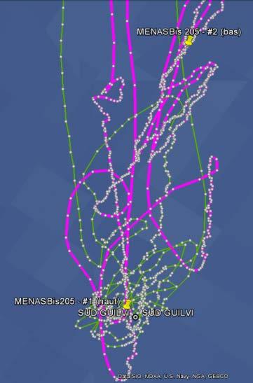
9 Campaign of acquisition: region of interest #1 Ushant traffic separation scheme: 3 flights -> sea state 4-5 & 5-6 Boat -> large size (>100m) Ground truth: Sea state: buoy, Météo France, AIS (provided by CETMEF) 10

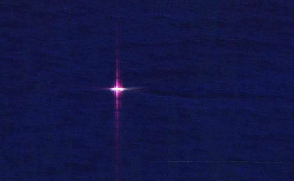
10 #1 Ushant traffic separation scheme: incidence 80 X-Hh 30 km 11
11 #1 Ushant traffic separation scheme: incidence 80 X-Hh AIS Ship #1 Ship #2 Lenght 105m 89m Heading Speed 7.2knts 7knts Experimental RCS Hh 50 dbm 2 48 dbm 2 Hv 25 dbm 2 26 dbm 2 Vv 42 dbm 2 42 dbm 2 12
12 Campaign of acquisition: region of interest #2 10 NM South of Le Guilvinec : 1 flight -> sea state 3-4 Boat -> 2 cooperative boats (15 & 20m) Circular acquisitions over clutter & cooperative boats Ground truth: Tracking GPS for both cooperative ships and an Inertial Measurement Unit installed into one of them. AIS signal from the non-cooperative boat (CETMEF). Sea state: buoys, Signal station, Météo France, 13

13 Ground truth for #2: sea state information Circular acquisition Azimuth step: 15 Swell from West Wind from South Wind map 14
14 Sea clutter over the full 360 in azimuth: Sea clutter Sigma0 vs azimuth angle, X-band Incidence 80 - Sea state Sigma0 (dbm2/m2) Hh Hv Vh Vv Poly. (Hh) Poly. (Vv) Relative azimuth angle (deg) Azimuth 0 Upwind / Azimuth 180 Downwind 15


15 Sea clutter response: the physical behavior Incidence 80 Hh polarization Vv polarization 16


16 Ground truth for #2: cooperative boat Rescue (15.5 m) Trawler (16m) 17
17 Ship measurements over the full 360 in azimuth: 70 Flight 2 run 8: incidence 70 - cooperative boat (SNSM) 30 RCS (dbm2) Hh Hv Vh Vv Observation angle (deg) 90 : cross viewing 0 : front viewing 180 : back viewing Maximum RCS: cross viewing Dihedral effect (max Hv) in one of the two sides 18
18 Campaign of acquisition: region of interest #3 Around Quiberon : 1 flight -> sea state 2-3 Boat Ground truth: -> opportunity and 4 Speedboats Tracking GPS for cooperative ship AIS signal from the non-cooperative boat (CETMEF). Sea state: buoys, Signal station, Météo France, 19
 = (Hh, Hv,")
19 #3 : Quiberon bay : incidence 70 X-band polarimetric SAR imagery (R, G, B) = (Hh, Hv, Vv) 20
 = (Hh, Hv, Vv)")
 = 22.0 dbm2 RCS(Vh) = 22.")
20 #3 : Quiberon bay : incidence 70 X-band polarimetric SAR imagery (R, G, B) = (Hh, Hv, Vv) Opportunity boat (48m, 12 knts): RCS(Hh) = 41.2 dbm2 RCS(Hv) = 22.0 dbm2 RCS(Vh) = 22.3 dbm2 RCS(Vv) = 36.9 dbm2 21


21 Sea clutter response: the physical behavior Incidence 70 Hh polarization Vv polarization 22

 = (Hh, Hv, Vv)")
22 #3 : Quiberon bay : incidence 70 X-band polarimetric SAR imagery (R, G, B) = (Hh, Hv, Vv) L-band polarimetric SAR imagery (R, G, B) = (Hh, Hv, Vv) 23
23 Sea response: multi-temporal analysis Sea clutter Sigma0 vs Sea state X-band, incidence 70 Sigma0 (dbm2/m2) Hh Hv Vv Sea state 24
24 Ongoing and future work X-band SAR data now processed and calibrated Ongoing work: Sea clutter response analysis (sea state, angles, polarization) done Ship RCS measurements (type of boat, angles, polarization) ongoing Detection capability (Ship to Clutter ratio) to do Future work: Polarization synthesis -> study the best polarization state (Em & Re) Detection algorithm Multy-frequency analysis 25
25 Conclusion ONERA has performed an extended airborne SAR campaign of acquisition dedicated to maritime surveillance analysis PolSAR data perfectly calibrated (amplitude and phase) at low grazing angle A special effort has been made on ground truth (sea state, wind, boat ) Step 1 : Sea clutter response is being analysed, Step 2 : Ship response will be analysed soon, Step 3 : Detection capability study, polarization synthesis 26


")
26 Speedboats. X-band polarimetric SAR imagery (R, G, B) = (Hh, Vv, Vv) Speed: 45 knt 27
THE NASA/JPL AIRBORNE SYNTHETIC APERTURE RADAR SYSTEM. Yunling Lou, Yunjin Kim, and Jakob van Zyl
 THE NASA/JPL AIRBORNE SYNTHETIC APERTURE RADAR SYSTEM Yunling Lou, Yunjin Kim, and Jakob van Zyl Jet Propulsion Laboratory California Institute of Technology 4800 Oak Grove Drive, MS 300-243 Pasadena,
Study of Polarimetric Calibration for Circularly Polarized Synthetic Aperture Radar
 Study of Polarimetric Calibration for Circularly Polarized Synthetic Aperture Radar 2016.09.07 CEOS WORKSHOP 2016 Yuta Izumi, Sevket Demirci, Mohd Zafri Baharuddin, and Josaphat Tetuko Sri Sumantyo JOSAPHAT
CHAPTER 1 INTRODUCTION
 1 CHAPTER 1 INTRODUCTION In maritime surveillance, radar echoes which clutter the radar and challenge small target detection. Clutter is unwanted echoes that can make target detection of wanted targets
SAOCOM-CS Mission and ESA Airborne Campaign Data
 SAOCOM-CS Mission and ESA Airborne Campaign Data Malcolm Davidson Head of the EOP Campaign Section Malcolm.Davidson@esa.int Objectives of presentation Introduce a new type of ESA SAR mission with Polarimetrice,
Towards a polarimetric SAR processor for airborne sensor
 1 Towards a polarimetric SAR processor for airborne sensor H. M.J. Cantalloube 1, B. Fromentin-Denoziere 1, and C. E. Nahum 2 1 ONERA (Office National d Études et Recherches Aérospatiales) Palaiseau, France
GMES Sentinel-1 Transponder Development
 GMES Sentinel-1 Transponder Development Paul Snoeij Evert Attema Björn Rommen Nicolas Floury Malcolm Davidson ESA/ESTEC, European Space Agency, Noordwijk, The Netherlands Outline 1. GMES Sentinel-1 overview
Dual Use Multi-Frequency Radar For Current Shear Mapping and Ship Target Classification
 Dual Use Multi-Frequency Radar For Current Shear Mapping and Ship Target Classification Dennis B. Trizna, Ph. D. Imaging Science Research, Inc. 9310A Old Keene Mill Road Burke, VA 22015 V 703 801-1417,
Towards a Polarimetric SAR Processor for Airborne Sensor
 PIERS ONLINE, VOL. 6, NO. 5, 2010 465 Towards a Polarimetric SAR Processor for Airborne Sensor H. M. J. Cantalloube 1, B. Fromentin-Denoziere 1, and C. E. Nahum 2 1 ONERA (Office National d Études et Recherches
Polarisation Capabilities and Status of TerraSAR-X
 Polarisation Capabilities and Status of TerraSAR-X Irena Hajnsek, Josef Mittermayer, Stefan Buckreuss, Kostas Papathanassiou German Aerospace Center Microwaves and Radar Institute irena.hajnsek@dlr.de
PALSAR calibration with passive antenna reflectors
 PALSAR calibration with passive antenna reflectors Alexander Zakharov, IRE RAS, Russia Peter Jerdev, SDB MPEI, Russia Alexey Sokolov, SDB MPEI, Russia E-mail: aizakhar@sunclass.ire.rssi.ru Bear Lakes calibration
Microwave Remote Sensing (1)
") Microwave Remote Sensing (1) Microwave sensing encompasses both active and passive forms of remote sensing. The microwave portion of the spectrum covers the range from approximately 1cm to 1m in wavelength.
Microwave Remote Sensing (1) Microwave sensing encompasses both active and passive forms of remote sensing. The microwave portion of the spectrum covers the range from approximately 1cm to 1m in wavelength.
The Current Status and Brief Results of Engineering Model for PALSAR-2 onboard ALOS-2 and Science Project
 The Current Status and Brief Results of Engineering Model for PALSAR-2 onboard ALOS-2 and Science Project + The 16 th KC meeting Japan Aerospace Exploration Agency Masanobu Shimada, Yukihiro KANKAKU The
Low frequency SAR data-dome collection with the Bright Sapphire II instrument
 Low frequency SAR data-dome collection with the Bright Sapphire II instrument Specialists meeting on Remote Intelligence of Building Interiors Sam DOODY May 2017 Low Frequency Airborne SAR Justification
ENVISAT ASAR MONTHLY REPORT MARCH 2012
 ENVISAT ASAR MONTHLY REPORT MARCH 2012 PUBLIC SUMMARY prepared by/préparé par IDEAS SAR Team reference/réference ENVI-CLVL-EOPG-TN-04-0009 issue/édition 73 revision/révision 0 date of issue/date d édition
RADARSAT-2 Image Quality and Calibration Update
 RADARSAT-2 Image Quality and Calibration Update by Dan Williams, Yiman Wang, Marielle Chabot, Pierre Le Dantec, Ron Caves, Yan Wu, Kenny James, Alan Thompson, Cathy Vigneron www.mdacorporation.com Image
S1-B N-Cyclic Performance Report Cycles 43 to 46 (03-July-2017 to 20-August-2017)
") S-1 MPC Cycles 43 to 46 (03-July-2017 to 20-August-2017) Reference: Nomenclature: MPC-0356 DI-MPC-NPR Issue: 2017-03. 5 Date: 2017,Sep.01 FORM-NT-GB-10-0 2017,Sep.01 i.1 Chronology Issues: Issue: Date:
S-1 MPC Cycles 43 to 46 (03-July-2017 to 20-August-2017) Reference: Nomenclature: MPC-0356 DI-MPC-NPR Issue: 2017-03. 5 Date: 2017,Sep.01 FORM-NT-GB-10-0 2017,Sep.01 i.1 Chronology Issues: Issue: Date:
NEXTMAP. P-Band. Airborne Radar Imaging Technology. Key Benefits & Features INTERMAP.COM. Answers Now
 INTERMAP.COM Answers Now NEXTMAP P-Band Airborne Radar Imaging Technology Intermap is proud to announce the latest advancement of their Synthetic Aperture Radar (SAR) imaging technology. Leveraging over
The Convair 580 SAR Facility Recent Activities and Future Opportunities
 The Convair 580 SAR Facility Recent Activities and Future Opportunities Dr. Carl E. Brown Emergencies Science and Technology Section Environment Canada Ottawa, Ontario ESTS Airborne Remote Sensing DC-3,
TerraSAR-X Calibration Status 2 Years in Flight
 2 Years in Flight Dirk Schrank, Marco Schwerdt, Markus Bachmann, Björn Döring, Clemens Schulz November 2009 CEOS 09 VG 1 Calibration Tasks Performed 2009 Introduction Challenge Schedule Re-Calibration
China. France Oceanography S A T. Overview of the near-real time wave products of the CFOSAT mission. e l l i t e
 China Overview of the near-real time wave products of the CFOSAT mission C. Tison (1), D. Hauser (2), S. Guibert (1), T. Amiot (1), L. Aouf (3), J.M. Lefèvre (3), B. Chapron (5), N. Corcoral (1), P. Castillan
Amherst, MA I This document has been appmoved. idistribution is unlimited.
 AD-A273 568 USE OF MICROWAVE POLARIMETRY TO ENHANCE SAR IMAGES OF THE OCEAN SURFACE r T IC (Y. -i ECTE DEC091993" T Dr. Robert E. McIntosh omnet: R.MCINTOSH Department of Electrical and Computer Engineering
TanDEM-X: Mission Status & Scientific Contribution
 TanDEM-X: Mission Status & Scientific Contribution Irena Hajnsek 1/2, Gerhard Krieger 1, Kostas Papathanassiou 1, Stefan Baumgartner 1, Marc Rodriguez-Cassola 1, Pau Prats 1, Maria Sanjuan Ferrer 1, Florian
MULTI-CHANNEL SAR EXPERIMENTS FROM THE SPACE AND FROM GROUND: POTENTIAL EVOLUTION OF PRESENT GENERATION SPACEBORNE SAR
 3 nd International Workshop on Science and Applications of SAR Polarimetry and Polarimetric Interferometry POLinSAR 2007 January 25, 2007 ESA/ESRIN Frascati, Italy MULTI-CHANNEL SAR EXPERIMENTS FROM THE
Sentinel-1A Radiometric Calibration
 Sentinel-1A Radiometric Calibration Peter Meadows 1, Alan Pilgrim 1, Riccardo Piantanida 2, Davide Riva 2, Nuno Miranda 3 (1) BAE Systems Applied Intelligence, West Hanningfield Road, Great Baddow, Chelmsford,
KaSAR final report. February 15 th, 2013
 Technical Assistance for the Deployment of Airborne-Based Ka-band SAR and Geophysical Measurements during the KaSAR 2012 Campaign KaSAR final report February 15 th, 2013 Auteurs Verified by Approved by
STORM: A NEW AIRBORNE POLARIMETRIC REAL-APERTURE RADAR FOR EARTH OBSERVATIONS
 STORM: A NEW AIRBORNE POLARIMETRIC REAL-APERTURE RADAR FOR EARTH OBSERVATIONS HAUSER Danièle, T. PODVIN, M. DECHAMBRE, R. VALENTIN, G. CAUDAL, J-F DALOZE CETP-IPSL (CNRS/université de Versailles-Saint-Quentin
OBSERVATION PERFORMANCE OF A PARIS ALTIMETER IN-ORBIT DEMONSTRATOR
 OBSERVATION PERFORMANCE OF A PARIS ALTIMETER IN-ORBIT DEMONSTRATOR Salvatore D Addio, Manuel Martin-Neira Acknowledgment to: Nicolas Floury, Roberto Pietro Cerdeira TEC-ETP, ETP, Electrical Engineering
UAV Detection and Localization Using Passive DVB-T Radar MFN and SFN
 UAV Detection and Localization Using Passive DVB-T Radar MFN and SFN Dominique Poullin ONERA Palaiseau Chemin de la Hunière BP 80100 FR-91123 PALAISEAU CEDEX FRANCE Dominique.poullin@onera.fr ABSTRACT
Calibration Assessment of RADARSAT-2 Polarimetry Using High Precision Transponders
 Calibration Assessment of RADARSAT-2 Polarimetry Using High Precision Transponders R Touzi, S Côté, RK Hawkins CCRS/CSA Acknowledgments S Nedelcu (CCRS) S Muir (CSA) 1 Outline-Polarimetric RADARSAT-2 Independent
The SARTOM Project; Tomography for enhanced target detection for foliage penetrating airborne SAR (First-Year Results)
") The SARTOM Project; Tomography for enhanced target detection for foliage penetrating airborne SAR (First-Year Results) Ralf Horn 1, Jens Fischer 1, Armando Marino 2, Matteo Nannini 1, Kim Partington 3,
The SARTOM Project; Tomography for enhanced target detection for foliage penetrating airborne SAR (First-Year Results) Ralf Horn 1, Jens Fischer 1, Armando Marino 2, Matteo Nannini 1, Kim Partington 3,
Synthetic Aperture Radar
 Synthetic Aperture Radar Picture 1: Radar silhouette of a ship, produced with the ISAR-Processor of the Ocean Master A Synthetic Aperture Radar (SAR), or SAR, is a coherent mostly airborne or spaceborne
Introduction Objective and Scope p. 1 Generic Requirements p. 2 Basic Requirements p. 3 Surveillance System p. 3 Content of the Book p.
 Preface p. xi Acknowledgments p. xvii Introduction Objective and Scope p. 1 Generic Requirements p. 2 Basic Requirements p. 3 Surveillance System p. 3 Content of the Book p. 4 References p. 6 Maritime
Special Projects Office. Mr. Lee R. Moyer Special Projects Office. DARPATech September 2000
 Mr. Lee R. Moyer DARPATech 2000 6-8 September 2000 1 CC&D Tactics Pose A Challenge to U.S. Targeting Systems The Challenge: Camouflage, Concealment and Deception techniques include: Masking: Foliage cover,
The Sentinel-1 Constellation
 The Sentinel-1 Constellation Evert Attema, Sentinel-1 Mission & System Manager AGRISAR and EAGLE Campaigns Final Workshop 15-16 October 2007 ESA/ESTECNoordwijk, The Netherlands Sentinel-1 Programme Sentinel-1
UAVSAR in Africa. Quality Assurance and Preliminary Results. Brian Hawkins, UAVSAR Team
 Photo by Sassan Saatchi UAVSAR in Africa Quality Assurance and Preliminary Results Brian Hawkins, UAVSAR Team CEOS SAR Cal/Val Workshop 2016 Copyright 2016 California Institute of Technology. Government
Remote Sensing. Ch. 3 Microwaves (Part 1 of 2)
") Remote Sensing Ch. 3 Microwaves (Part 1 of 2) 3.1 Introduction 3.2 Radar Basics 3.3 Viewing Geometry and Spatial Resolution 3.4 Radar Image Distortions 3.1 Introduction Microwave (1cm to 1m in wavelength)
Remote Sensing Ch. 3 Microwaves (Part 1 of 2) 3.1 Introduction 3.2 Radar Basics 3.3 Viewing Geometry and Spatial Resolution 3.4 Radar Image Distortions 3.1 Introduction Microwave (1cm to 1m in wavelength)
Sentinel-1 Overview. Dr. Andrea Minchella
 Dr. Andrea Minchella 21-22/01/2016 ESA SNAP-Sentinel-1 Training Course Satellite Applications Catapult - Electron Building, Harwell, Oxfordshire Contents Sentinel-1 Mission Sentinel-1 SAR Modes Sentinel-1
WHAT IS NEXT IN EARTH OBSERVATION. SkyMed Mission
 WHAT IS NEXT IN EARTH OBSERVATION COSMO-SkyMed SkyMed Mission Paolo Ammendola Italian Space Agency Florence, Sept. 19, 2001 ammendola@asi asi.it THE NEEDS Market studies indicate that the value of the
2006 Fynmeet Sea Clutter Measurement Trial
 26 Fynmeet Sea Clutter Measurement Trial Dataset Overview for 25-Jul-26 Dr PL Herselman 26 Fynmeet Sea Clutter Measurement Trial : Dataset Overview for 25-Jul-26 by Dr PL Herselman Published 6-Sep-27 15:7:13
Satellite Technologies for Fisheries Monitoring, Control and Surveillance (MCS)
") JRC IPSC Maritime Affairs 1 Satellite Technologies for Fisheries Monitoring, Control and Surveillance (MCS) Juan Cicuendez, Marlene Alvarez JRC Info Day Madrid, 2 June 2010 IPSC - Institute for the Protection
JRC IPSC Maritime Affairs 1 Satellite Technologies for Fisheries Monitoring, Control and Surveillance (MCS) Juan Cicuendez, Marlene Alvarez JRC Info Day Madrid, 2 June 2010 IPSC - Institute for the Protection
Co-ReSyF RA lecture: Vessel detection and oil spill detection
 This project has received funding from the European Union s Horizon 2020 Research and Innovation Programme under grant agreement no 687289 Co-ReSyF RA lecture: Vessel detection and oil spill detection
Detection of traffic congestion in airborne SAR imagery
 Detection of traffic congestion in airborne SAR imagery Gintautas Palubinskas and Hartmut Runge German Aerospace Center DLR Remote Sensing Technology Institute Oberpfaffenhofen, 82234 Wessling, Germany
Sentinel-1A Tile #11 Failure
 MPC-S1 Reference: Nomenclature: MPC-0324 OI-MPC-ACR Issue: 1. 2 Date: 2016,Oct.13 FORM-NT-GB-10-1 MPC-0324 OI-MPC-ACR V1.2 2016,Oct.13 i.1 Chronology Issues: Issue: Date: Reason for change: Author 1.0
Soil moisture retrieval using ALOS PALSAR
 Soil moisture retrieval using ALOS PALSAR T. J. Jackson, R. Bindlish and M. Cosh USDA ARS Hydrology and Remote Sensing Lab, Beltsville, MD J. Shi University of California Santa Barbara, CA November 6,
RADARSAT-2 Program Update Daniel De Lisle Canadian Space Agency
 RADARSAT-2 Program Update Daniel De Lisle Canadian Space Agency Presentation outline RADARSAT-1 Update RADARSAT-2 Mission description Mission Objectives System Characteristics Data Commercialization/Allocation
ALOS and PALSAR. Masanobu Shimada
 ALOS and PALSAR Masanobu Shimada Earth Observation Research Center, National Space Development Agency of Japan, Harumi 1-8-10, Harumi island triton square office tower X 22, Chuo-Ku, Tokyo-To, Japan, 104-6023,
A Bistatic HF Radar for Current Mapping and Robust Ship Tracking
 A Bistatic HF Radar for Current Mapping and Robust Ship Tracking Dennis Trizna Imaging Science Research, Inc. V. 703-801-1417 dennis @ isr-sensing.com www.isr-sensing.com Objective: Develop methods for
KONGSBERG SATELLITE SERVICES 2017 Line Steinbakk, Director Programs. Himmel og hav - Ålesund 3. Oktober 2017
 KONGSBERG SATELLITE SERVICES 2017 Line Steinbakk, Director Programs Himmel og hav - Ålesund 3. Oktober 2017 KSAT HQ IN TROMSØ 69N Established in 1967 Kongsberg Satellite Services since 2002 World leading
Sentinel-1 Calibration and Performance
 Sentinel-1 Calibration and Performance Paul Snoeij Evert Attema Björn Rommen Nicolas Floury Berthyl Duesmann Malcolm Davidson Ramon Torres European Space Agency Sentinel-1 Mission Objectives Component
Theoretical Simulations of GNSS Reflections from Bare and Vegetated Soils
 Theoretical Simulations of GNSS Reflections from Bare and Vegetated Soils R. Giusto 1, L. Guerriero, S. Paloscia 3, N. Pierdicca 1, A. Egido 4, N. Floury 5 1 DIET - Sapienza Univ. of Rome, Rome DISP -
A Bistatic HF Radar for Current Mapping and Robust Ship Tracking
 A Bistatic HF Radar for Current Mapping and Robust Ship Tracking D. B. Trizna Imaging Science Research, Inc. 6103B Virgo Court Burke, VA, 22015 USA Abstract- A bistatic HF radar has been developed for
Coastal Surveillance: Complex system of X-band and High Frequency Surface Wave Radars
 Coastal Surveillance: Complex system of X-band and High Frequency Surface Wave Radars N. Colin (1), G. Auffray (2) (1)Thales Air Systems, Surface Radar Hameau de Roussigny 91470 Limours, France nathalie.colin@thalesgroup.com
CNES PRIORITIES IN POLAR AND CRYOSPHERE RESEARCH
 Polar Space Task Group 3rd Session CNES PRIORITIES IN POLAR AND CRYOSPHERE RESEARCH Juliette Lambin, Steven Hosford Wednesday, May 22th, 2013 Paris, France 1 OUTLINE CNES MISSIONS FOR POLAR/CRYOSPHERE
Non Stationary Bistatic Synthetic Aperture Radar Processing: Assessment of Frequency Domain Processing from Simulated and Real Signals
 PIERS ONLINE, VOL. 5, NO. 2, 2009 196 Non Stationary Bistatic Synthetic Aperture Radar Processing: Assessment of Frequency Domain Processing from Simulated and Real Signals Hubert M. J. Cantalloube Office
Exploring the Potential Pol-InSAR Techniques at X-Band: First Results & Experiments from TanDEM-X
 Exploring the Potential Pol-InSAR Techniques at X-Band: First Results & Experiments from TanDEM-X K. Papathanassiou, F. Kugler, J-S. Kim, S-K. Lee, I. Hajnsek Microwaves and Radar Institute (DLR-HR) German
The Biomass Mission, status of the satellite system
 The Biomass Mission, status of the satellite system M. Arcioni, P. Bensi, M. Fehringer, F. Fois, F. Heliere, K. Scipal PolInSAR/Biomass Meeting 2015, ESRIN 29/01/2015 1. Key facts (lifetime, duty cycle
Report on CEOS WGCV SAR Subgroup Activities
 Report on CEOS WGCV SAR Subgroup Activities CEOS WGCV 37 th Plenary ESRIN, Frascati/Italy February 17-20, 2014 M. Zink Chair CEOS WGCV SAR Subgroup German Aerospace Center (DLR) manfred.zink@dlr.de http://sarcv.ceos.org
Adaptive SAR Results with the LiMIT Testbed
 Adaptive SAR Results with the LiMIT Testbed Gerald Benitz Adaptive Sensor Array Processing Workshop 7 June 2005 999999-1 Outline LiMIT collection platform SAR sidelobe recovery Electronic Protection (EP)
Using Emulated Bistatic Radar in Highly Coherent Applications: Overview of Results
 Using Emulated Bistatic Radar in Highly Coherent Applications: Overview of Results James Palmer 1,2, Marco Martorella 3, Brad Littleton 4, and John Homer 1 1 The School of ITEE, The University of Queensland,
SCATTERING POLARIMETRY PART 1. Dr. A. Bhattacharya (Slide courtesy Prof. E. Pottier and Prof. L. Ferro-Famil)
") SCATTERING POLARIMETRY PART 1 Dr. A. Bhattacharya (Slide courtesy Prof. E. Pottier and Prof. L. Ferro-Famil) 2 That s how it looks! Wave Polarisation An electromagnetic (EM) plane wave has time-varying
SCATTERING POLARIMETRY PART 1 Dr. A. Bhattacharya (Slide courtesy Prof. E. Pottier and Prof. L. Ferro-Famil) 2 That s how it looks! Wave Polarisation An electromagnetic (EM) plane wave has time-varying
SAR Multi-Temporal Applications
 SAR Multi-Temporal Applications 83230359-DOC-TAS-EN-001 Contents 2 Advantages of SAR Remote Sensing Technology All weather any time Frequencies and polarisations Interferometry and 3D mapping Change Detection
Next Generation Operational Met Office Weather Radars and Products
 Next Generation Operational Met Office Weather Radars and Products Pierre TABARY Jacques PARENT-DU-CHATELET Observing Systems Dept. Météo France Toulouse, France pierre.tabary@meteo.fr WakeNet Workshop,
Ionospheric Structure Imaging with ALOS PALSAR
 The Second ALOS PI Symposium Rhodes, Greece November 3 7, 008 Ionospheric Structure Imaging with ALOS PALSAR PI Number: 37 JAXA-RA PI: Jong-Sen Lee, Thomas L. Ainsworth and Kun-Shan Chen CSRSR, National
A High-Resolution, Four-Band SAR Testbed with Real-Time Image Formation
 A High-Resolution, Four-Band SAR Testbed with Real-Time Image Formation Bruce Walker, Grant Sander, Marty Thompson, Bryan Burns, Rick Fellerhoff, and Dale Dubbert Sandia National Laboratories, P. O. Box
WHAT S INSIDE THE BUILDING?
 WHAT S INSIDE THE BUILDING? Patrik Dammert, Hans Hellsten, Anders Åhlander, Anders Nilsson, Magnus Gisselfält, Niklas Eriksson Aerospace Technology Congress 2016 Flygteknik 2016 This document and the information
SINCE the first unclassified papers on synthetic aperture
 1852 IEEE TRANSACTIONS ON GEOSCIENCE AND REMOTE SENSING, VOL. 36, NO. 6, NOVEMBER 1998 EMISAR: An Absolutely Calibrated Polarimetric - and -band SAR Erik Lintz Christensen, Member, IEEE, Niels Skou, Senior
MOBILE RAPID-SCANNING X-BAND POLARIMETRIC (RaXPol) DOPPLER RADAR SYSTEM Andrew L. Pazmany 1 * and Howard B. Bluestein 2
 DOPPLER RADAR SYSTEM Andrew L. Pazmany 1 * and Howard B. Bluestein 2") 16B.2 MOBILE RAPID-SCANNING X-BAND POLARIMETRIC (RaXPol) DOPPLER RADAR SYSTEM Andrew L. Pazmany 1 * and Howard B. Bluestein 2 1 ProSensing Inc., Amherst, Massachusetts 2 University of Oklahoma, Norman,
16B.2 MOBILE RAPID-SCANNING X-BAND POLARIMETRIC (RaXPol) DOPPLER RADAR SYSTEM Andrew L. Pazmany 1 * and Howard B. Bluestein 2 1 ProSensing Inc., Amherst, Massachusetts 2 University of Oklahoma, Norman,
Detection of Multipath Propagation Effects in SAR-Tomography with MIMO Modes
 Detection of Multipath Propagation Effects in SAR-Tomography with MIMO Modes Tobias Rommel, German Aerospace Centre (DLR), tobias.rommel@dlr.de, Germany Gerhard Krieger, German Aerospace Centre (DLR),
DETECTION OF SMALL AIRCRAFT WITH DOPPLER WEATHER RADAR
 DETECTION OF SMALL AIRCRAFT WITH DOPPLER WEATHER RADAR Svetlana Bachmann 1, 2, Victor DeBrunner 3, Dusan Zrnic 2 1 Cooperative Institute for Mesoscale Meteorological Studies, The University of Oklahoma
ALOS-Indonesia POLinSAR Experiment (AIPEX): First Result*
: First Result*") ALOS-Indonesia POLinSAR Experiment (AIPEX): First Result* Mahmud Raimadoya(1), Ludmila Zakharova(2), Bambang Trisasongko(1), Nurwadjedi(3) (1) Bogor Agricultural University (IPB), P.O. Box 2049, Bogor
ALOS-Indonesia POLinSAR Experiment (AIPEX): First Result* Mahmud Raimadoya(1), Ludmila Zakharova(2), Bambang Trisasongko(1), Nurwadjedi(3) (1) Bogor Agricultural University (IPB), P.O. Box 2049, Bogor
Imaging radar Imaging radars provide map-like coverage to one or both sides of the aircraft.
 CEE 6100 / CSS 6600 Remote Sensing Fundamentals 1 Imaging radar Imaging radars provide map-like coverage to one or both sides of the aircraft. Acronyms: RAR real aperture radar ("brute force", "incoherent")
Calibration Concepts for Future Low Frequency SAR Systems. Jens Reimann, Marco Schwerdt, Sravan Kumar Aitha and Manfred Zink
 Calibration Concepts for Future Low Frequency SAR Systems Jens Reimann, Marco Schwerdt, Sravan Kumar Aitha and Manfred Zink DLR.de Chart 2 Low Frequency SAR Missions OHB DLR.de Chart 3 BIOMASS - Facts
Microwave Sensors Subgroup (MSSG) Report
 Report") Microwave Sensors Subgroup (MSSG) Report CEOS WGCV-35 May 13-17, 2013, Shanghai, China DONG, Xiaolong, MSSG Chair CAS Key Laboratory of Microwave Remote Sensing National Space Science Center Chinese Academy
Microwave Sensors Subgroup (MSSG) Report CEOS WGCV-35 May 13-17, 2013, Shanghai, China DONG, Xiaolong, MSSG Chair CAS Key Laboratory of Microwave Remote Sensing National Space Science Center Chinese Academy
POLARIMETRIC MEASUREMENTS OVER THE SEA-SURFACE WITH THE AIRBORNE STORM RADAR IN THE CONTEXT OF THE GEOPHYSICAL VALIDATION OF THE ENVISAT ASAR
 POLARIMETRIC MEASUREMENTS OVER THE SEA-SURFACE WITH THE AIRBORNE STORM RADAR IN THE CONTEXT OF THE GEOPHYSICAL VALIDATION OF THE ENVISAT ASAR HAUSER Danièle, T. PODVIN, M. DECHAMBRE, G. CAUDAL, A MOUCHE,
Introduction Active microwave Radar
 RADAR Imaging Introduction 2 Introduction Active microwave Radar Passive remote sensing systems record electromagnetic energy that was reflected or emitted from the surface of the Earth. There are also
TerraSAR-X Calibration Ground Equipment
 86 Proceedings of WFMN07, Chemnitz, Germany TerraSAR-X Calibration Ground Equipment Björn J. Döring, Marco Schwerdt, Robert Bauer Microwaves and Radar Institute German Aerospace Center (DLR) Oberpfaffenhofen,
Port Security and Technology - the U.S. Perspective. Michael S. Bruno Stevens Institute of Technology March 14, 2012
 Port Security and Technology - the U.S. Perspective Michael S. Bruno Stevens Institute of Technology March 14, 2012 CSR A Department of Homeland Security National Center of Excellence for Port Security
Sentinel-1 System Overview
 Sentinel-1 System Overview Dirk Geudtner, Rámon Torres, Paul Snoeij, Malcolm Davidson European Space Agency, ESTEC Global Monitoring for Environment and Security (GMES) EU-led program aiming at providing
RADARSAT-2 Modes and Applications
 RADARSAT-2 Modes and Applications Gordon Staples MDA Geospatial Services February 6, 2017 1 Introduction RADARSAT-2 was developed to meet operational needs via a versatile space segment and a responsive
EE 529 Remote Sensing Techniques. Introduction
 EE 529 Remote Sensing Techniques Introduction Course Contents Radar Imaging Sensors Imaging Sensors Imaging Algorithms Imaging Algorithms Course Contents (Cont( Cont d) Simulated Raw Data y r Processing
KONGSBERG. WORLD CLASS through people, technology and dedication WORLD CLASS through people, technology and dedication
 WORLD CLASS through people, technology and dedication WORLD CLASS through people, technology and dedication Skipsdeteksjon fra radarsatellitter SkipSat Richard Hallr Kongsberg Satellite Services AS (KSAT)
Bistatic experiment with the UWB-CARABAS sensor - first results and prospects of future applications
 Zurich Open Repository and Archive University of Zurich Main Library Strickhofstrasse 39 CH-8057 Zurich www.zora.uzh.ch Year: 2009 Bistatic experiment with the UWB-CARABAS sensor - first results and prospects
Contents Preface Micro-Doppler Signatures Review, Challenges, and Perspectives Phenomenology of Radar Micro-Doppler Signatures
 Contents Preface xi 1 Micro-Doppler Signatures Review, Challenges, and Perspectives 1 1.1 Introduction 1 1.2 Review of Micro-Doppler Effect in Radar 2 1.2.1 Micro-Doppler Signatures of Rigid Body Motion
Radar Imaging Wavelengths
 A Basic Introduction to Radar Remote Sensing ~~~~~~~~~~ Rev. Ronald J. Wasowski, C.S.C. Associate Professor of Environmental Science University of Portland Portland, Oregon 3 November 2015 Radar Imaging
Interferometric Cartwheel 1
 The Interferometric CartWheel A wheel of passive radar microsatellites for upgrading existing SAR projects D. Massonnet, P. Ultré-Guérard (DPI/EOT) E. Thouvenot (DTS/AE/INS/IR) Interferometric Cartwheel
Ka-Band Systems and Processing Approaches for Simultaneous High-Resolution Wide-Swath SAR Imaging and Ground Moving Target Indication
 Ka-Band Systems and Processing Approaches for Simultaneous High-Resolution Wide-Swath SAR Imaging and Ground Moving Target Indication Advanced RF Sensors and Remote Sensing Instruments 2014 Ka-band Earth
CYGNSS Mission Update
 International Ocean Vector Wind Science Team Meeting Portland, OR 19-21 May 2015 CYGNSS Mission Update Chris Ruf (1) CYGNSS Principal Investigator Paul Chang (2), Maria Paola Clarizia (1), Scott Gleason
Radar/Lidar Sensors SESAR XP1 Trials at CDG airport WakeNet-USA October 2012 Boeing, Seattle, USA
 www.thalesgroup.com Radar/Lidar Sensors SESAR XP1 Trials at CDG airport WakeNet-USA 17-18 October 2012 Boeing, Seattle, USA 2 / Agenda SESAR P12.2.2 overview Organization Development plan Planning and
Microwave Sensors Subgroup (MSSG) Report
 Report") Microwave Sensors Subgroup (MSSG) Report Feb 17-20, 2014, ESA ESRIN, Frascati, Italy DONG, Xiaolong, MSSG Chair National Space Science Center Chinese Academy of Sciences (MiRS,NSSC,CAS) Email: dongxiaolong@mirslab.cn
Microwave Sensors Subgroup (MSSG) Report Feb 17-20, 2014, ESA ESRIN, Frascati, Italy DONG, Xiaolong, MSSG Chair National Space Science Center Chinese Academy of Sciences (MiRS,NSSC,CAS) Email: dongxiaolong@mirslab.cn
 Performance Comparison between Dual Polarimetric and Fully Polarimetric data for DInSAR Subsidence monitoring Dani Monells, Jordi J. Mallorquí Universitat Politècnica de Catalunya, Departament de Teoria
Contents. Analysis of Wave Fields from Temporal Sequences of X-Band Marine Radar Images. Sensors for Wave Measurements (I) Wave Measurements
 Wave Measurements") Analysis of Wave Fields from Temporal Sequences of X-Band Marine Radar Images José Carlos Nieto Borge Dpt. of Signal Theory and Communications University of Alcalá. Spain josecarlos.nieto@uah.es Contents
Analysis of Wave Fields from Temporal Sequences of X-Band Marine Radar Images José Carlos Nieto Borge Dpt. of Signal Theory and Communications University of Alcalá. Spain josecarlos.nieto@uah.es Contents
SAR Imagery: Airborne or Spaceborne? Presenter: M. Lorraine Tighe PhD
 SAR Imagery: Airborne or Spaceborne? Presenter: M. Lorraine Tighe PhD Introduction The geospatial community has seen a plethora of spaceborne SAR imagery systems where there are now extensive archives
METOP SECOND GENERATION SCATTEROMETER MISSION
 METOP SECOND GENERATION SCATTEROMETER MISSION Franco Fois, Chung-Chi Lin, Hubert Barré, Maurizio Betto, Marc Loiselet and Graeme Mason European Space Agency, Keplerlaan 1, 2200 AG Noordwijk ZH, The Netherlands
PAZ Product Definition
 PAZ Product Definition CALVAL Centre Juan Manuel Cuerda Muñoz, Javier del Castillo Mena, Adolfo López Pescador, Nuria Gimeno Martínez, Nuria Casal Vázquez, Patricia Cifuentes Revenga, Marcos García Rodríguez,
Scalable Front-End Digital Signal Processing for a Phased Array Radar Demonstrator. International Radar Symposium 2012 Warsaw, 24 May 2012
 Scalable Front-End Digital Signal Processing for a Phased Array Radar Demonstrator F. Winterstein, G. Sessler, M. Montagna, M. Mendijur, G. Dauron, PM. Besso International Radar Symposium 2012 Warsaw,
Biomass, a polarimetric interferometric P-band SAR mission
 Biomass, a polarimetric interferometric P-band SAR mission M. Arcioni, P. Bensi, M. Fehringer, F. Fois, F. Heliere, N. Miranda, K. Scipal Fringe 2015, ESRIN 27/03/2015 The Biomass Mission 1. Biomass was
the use of satellite radar to improve surveillance of oil pollution over large areas
 Groupe de travail ORFEO - Mer et Littoral Réunion du 14 octobre 2004 the use of satellite radar to improve surveillance of oil pollution over large areas François Parthiot Cedre - Delegate for the Mediterranean
Faraday rotation estimation from unfocussed ALOS PALSAR raw data
 Faraday rotation estimation from unfocussed ALOS PALSAR raw data arco Lavalle 1 3, E. Pottier 2, D. Solimini 1, N. iranda 3 1 DISP, Tor Vergata University, Rome, Italy 2 IETR UR CNRS 6164, University of
APPLICATION OF OCEAN RADAR ON THE BALTIC, FEATURES AND LIMITATIONS
 APPLICATION OF OCEAN RADAR ON THE BALTIC, FEATURES AND LIMITATIONS Thomas Helzel, Matthias Kniephoff, Leif Petersen, Markus Valentin Helzel Messtechnik GmbH e-mail: helzel@helzel.com Presentation at Hydro
Sub-Mesoscale Imaging of the Ionosphere with SMAP
 Sub-Mesoscale Imaging of the Ionosphere with SMAP Tony Freeman Xiaoqing Pi Xiaoyan Zhou CEOS Workshop, ASF, Fairbanks, Alaska, December 2009 1 Soil Moisture Active-Passive (SMAP) Overview Baseline Mission