Low frequency SAR data-dome collection with the Bright Sapphire II instrument
|
|
|
- Nathaniel Goodman
- 5 years ago
- Views:
Transcription
1 Low frequency SAR data-dome collection with the Bright Sapphire II instrument Specialists meeting on Remote Intelligence of Building Interiors Sam DOODY May 2017
2 Low Frequency Airborne SAR Justification and potential 2

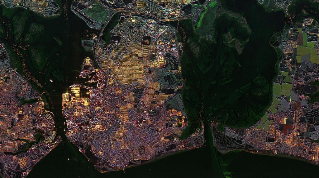
3 Airborne SAR Airborne SAR is a useful method to gather ISTAR information. Multiple airborne campaigns have proven the advantages of such systems, which include: Remote stand-off All weather, day-night sensing capability Height information and 3D tomography (with adequate acquisitions) Multi-frequency system Potential for customisation Flexibility on operation X-band fully polarimetric SAR image, Milton Keynes 3
4 Low Frequency RF The use of low frequency RF for communications applications requiring building penetration is well established, with very common examples such as mobile and Wi-Fi. The attenuation rate of building penetration depends on: Signal frequency Building construction and materials Penetration angle 4 Calculated attenuation rates of building materials. Source: OFCOM report on Building Materials and Propagation


5 LF SAR Low frequency SAR is a solution to seeing inside buildings and facilities to detect activity or occupancy. An airborne demonstrator campaign has been performed to prove the potential capabilities of LF SAR. The key elements of the demonstration programme is: Development of Bright Sapphire II LF SAR sensor Integration of the sensor onto the trials aircraft Planning and undertaking of trials to acquire data Conversion of raw data to CPHD format to enable exploitation. LFSAR Data Dome 5 LFSAR Data Dome demonstrator key elements
6 LFSAR Data Dome Trials and instrument overview 6

7 Trials The trial objective is to collect data in such a way that it can be coherently combined to form a Data-Dome. Data-Dome refers to a collected dataset that covers a hemisphere over the target area defined in k-space. The data-dome collection enables tomographic and volumetric information to be extracted about the building. To achieve the objective, circular acquisitions were used to image over 360 of azimuth (α) and range of incidence angles (θ), with a height separation adequate to avoid height ambiguities during tomographic combination. Linear acquisitions were added to the trials to verify instrument performance and to be able to fly closer to the target for enhanced signal-to-noise ratio. 7 Data Dome representation in k-space


 with internal targets (Right) DD7 Wooden")

8 Targets Data collected over a range of different target types (tent, wooden shed, plastic Shed, wooden lodge, brick buildings) to explore the capability of penetration of buildings of a range of material and construction types that cannot be penetrated by other sensors (optical, infrared). For each building structure, calibration targets were placed inside and outside the building to assess the potential for building penetration. Ground truth was performed in each target to identify internal features. Some examples of imaged targets: DD6 Brick Building-Sports Facility (left) with internal targets (Right) DD7 Wooden Scandinavian Lodges (left) with internal targets (Right) 8 DD1, DD2 Tent, Wooden Shed, Plastic Shed and calibration targets (internal and external) DD17 Two storey Brick Building-Residential (left) with internal targets (Right)

9 Sensor The Bright Sapphire II sensor is capable of operating at low frequencies with a large bandwidth ( MHz), which can offer a slant range resolution of 12cm, uncommon at such low frequencies. The sensor took the key elements of the original Bright Sapphire replacing the Front End Electronics, implementing a more compact antenna and doing the necessary modifications and upgrades to the Back End. The system is capable of also transmitting low-band (UHF, VHF, P, L-band), S-band and X-band simultaneously with additional aircraft installation. Parameter Centre frequency Bandwidth Polarisation HPA peak transmit power Tx Duty Cycle (max) 750MHz 1.1GHz Value Quad polarisation 80W Rx Duty Cycle (max) 20% System Noise Figure System losses Instrument mass CW (10W) 2.6dB 12.1dB kg Power consumption (max) 800W 9 Bright Sapphire II instrument top-level architecture Tx Notching ability Yes Bright Sapphire II instrument key parameters


10 Aircraft integration The sensor is current deployed on a B200 Super King Air (G-IMEA): The sinuous antenna is mounted within the radome. The instrument is installed into a compact E-rack that fits onto seat rails in the cabin. It is the largest pod installed on an aircraft of its category. 10 Trials aircraft showing large underbelly radome Instrument mounted in E-rack in aircraft cabin
11 NESZ [db] NESZ [db] Predicted performance The main limitations to NESZ performance are: Maximum antenna size that can be fitted in the aircraft, and therefore, limited gain. Need to notch part of the Tx spectrum due to OfCom regulations in the UK. Flight accuracy and weather conditions that will cause variations in the pointing angle and ground speed (circular runs). In circular runs, minimum distance to the target is limited by the aircraft turning rate and angle of bank. Linear acquisitions have been used for some collections to have enhanced NESZ performance (and hence, SNR) Mode 61, Circular Data-Dome Reference mode Mode 70, Liner Data-Dome Near incidence angle (deg) -35 Near incidence angle (deg) 11 Sinuous NESZ Full Band (no notching) Notched NESZ NESZ with ±7.5 AoB NESZ with ±7.5 AoB at max ground speed Sinuous NESZ Full Band (no notching) Notched NESZ Notched NESZ at max ground speed

12 Key challenges The key challenges encountered with the development and operation of such a sensor are: Antenna performance and accommodation The sinuous antenna used has a low gain and a very wide beamwidth illuminating reverse ambiguous regions Higher gain antennas, such as the log periodic, could not be accommodated on a small aircraft. Ofcom Licence Required for radio transmission in the UK, requiring notches in the transmit signal. St1 St2 St3 St4 St5 St6 12


13 Key challenges The key challenges encountered with the development and operation of such a sensor are: Interferers The frequency band of operation contains a lot of strong in-band interferers. A simple method of nulling bins in the data containing interferers has been used for the preliminary results presented. However, due to the number and range of strengths of interferer, a robust method is required. Interferer spectrum Spectrum after simple interferer removal Interferer removal example for stitches 5 (left) and 6 (right) 13
14 LFSAR Data Dome Results Capability of remote sensing building interiors 14


15 Preliminary results: Potential for building penetration 1m resolution not finest possible! An initial assessment of the data after the first week on collection DD1/DD2/DD7 shows the potential for building penetration. The corner reflectors inside the tent, wooden shed, plastic shed and wooden lodge are all detected with the instrument. 15 DD1_b quad polar image, showing the building structures inside which each calibration target was placed


16 Preliminary results: Potential for building penetration 1m resolution not finest possible! An initial assessment of DD6 (brick Mablethorpe Athletics Club), comparing the upper half of the spectrum and the lower half, appears to show the internal trihedral when using the lower frequencies. Stitch 4,5,6 imagery Stitch 1,2,3 imagery Optical image of building Trihedral inside building 16
17 Conclusions The airborne trials undertaken with the Bright Sapphire II sensor have proven the instrument capability to see through optically opaque objects and detect targets inside buildings of different construction types. Further enhanced processing including a robust method for interferer removal will allow full exploitation of the data: Better resolution: cm slant range resolution (after notching). 3D tomographic and volumetric exploitation of the building. To observe weaker objects within buildings then a larger instrument development would be required to improve SNR and reduce the impact of interferers on the data. Data can be made available to those that would like to process and analyse it. 17 Imagery from DD17 processing only stitch 1 VV ( MHz) at 2m resolution.

18 Thank you Copyright mention
THE NASA/JPL AIRBORNE SYNTHETIC APERTURE RADAR SYSTEM. Yunling Lou, Yunjin Kim, and Jakob van Zyl
 THE NASA/JPL AIRBORNE SYNTHETIC APERTURE RADAR SYSTEM Yunling Lou, Yunjin Kim, and Jakob van Zyl Jet Propulsion Laboratory California Institute of Technology 4800 Oak Grove Drive, MS 300-243 Pasadena,
Detection of Multipath Propagation Effects in SAR-Tomography with MIMO Modes
 Detection of Multipath Propagation Effects in SAR-Tomography with MIMO Modes Tobias Rommel, German Aerospace Centre (DLR), tobias.rommel@dlr.de, Germany Gerhard Krieger, German Aerospace Centre (DLR),
Study of Polarimetric Calibration for Circularly Polarized Synthetic Aperture Radar
 Study of Polarimetric Calibration for Circularly Polarized Synthetic Aperture Radar 2016.09.07 CEOS WORKSHOP 2016 Yuta Izumi, Sevket Demirci, Mohd Zafri Baharuddin, and Josaphat Tetuko Sri Sumantyo JOSAPHAT
GMES Sentinel-1 Transponder Development
 GMES Sentinel-1 Transponder Development Paul Snoeij Evert Attema Björn Rommen Nicolas Floury Malcolm Davidson ESA/ESTEC, European Space Agency, Noordwijk, The Netherlands Outline 1. GMES Sentinel-1 overview
Acknowledgment. Process of Atmospheric Radiation. Atmospheric Transmittance. Microwaves used by Radar GMAT Principles of Remote Sensing
 GMAT 9600 Principles of Remote Sensing Week 4 Radar Background & Surface Interactions Acknowledgment Mike Chang Natural Resources Canada Process of Atmospheric Radiation Dr. Linlin Ge and Prof Bruce Forster
Low Frequency 3D Synthetic Aperture Radar for the Remote Intelligence of Building Interiors
 Aperture Radar for the Remote Intelligence of Building Interiors D. Andre Centre for Electronic Warfare, Cyber and Information, Cranfield University UNITED KINGDOM d.andre@cranfield.ac.uk B. Faulkner Australian
SHIP DETECTION AND SEA CLUTTER CHARACTERISATION USING X&L BAND FULL-POLARIMETRIC AIRBORNE SAR DATA
 SHIP DETECTION AND SEA CLUTTER CHARACTERISATION USING X&L BAND FULL-POLARIMETRIC AIRBORNE SAR DATA S. Angelliaume, Ph. Martineau (ONERA) Ph. Durand, T. Cussac (CNES) Context CNES/ONERA study of Space System
Tracking of Moving Targets with MIMO Radar
 Tracking of Moving Targets with MIMO Radar Peter W. Moo, Zhen Ding Radar Sensing & Exploitation Section DRDC Ottawa Research Centre Presentation to 2017 NATO Military Sensing Symposium 31 May 2017 waveform
Notice of coordination procedure required under spectrum access licences for the 2.6 GHz band
 Notice of coordination procedure required under spectrum access licences for the 2.6 GHz band Coordination with aeronautical radionavigation radar in the 2.7 GHz band Notice Publication date: 1 March 2013
Cell Extender Antenna System Design Guide Lines
 Cell Extender Antenna System Design Guide Lines 1. General The design of an Antenna system for a Cell Extender site needs to take into account the following specific factors: a) The systems input and output
Propagation Modelling White Paper
 Propagation Modelling White Paper Propagation Modelling White Paper Abstract: One of the key determinants of a radio link s received signal strength, whether wanted or interfering, is how the radio waves
Microwave Remote Sensing (1)
") Microwave Remote Sensing (1) Microwave sensing encompasses both active and passive forms of remote sensing. The microwave portion of the spectrum covers the range from approximately 1cm to 1m in wavelength.
Microwave Remote Sensing (1) Microwave sensing encompasses both active and passive forms of remote sensing. The microwave portion of the spectrum covers the range from approximately 1cm to 1m in wavelength.
Calibration Concepts of Multi-Channel Spaceborne SAR
 DLR.de Chart 1 > CEOS Workshop 2016 > Tobias Rommel > September 7 th, 2016 Calibration Concepts of Multi-Channel Spaceborne SAR T. Rommel, F. Queiroz de Almeida, S. Huber, M. Jäger, G. Krieger, C. Laux,
System configurations. Main features I SG 64 SOLUTION FOR
 T- DualScan SG 64 The most accurate solution for testing antennas and wireless devices: SG 64 has been developed to measure stand alone antennas or antennas integrated in subsystems. It is also ideal for
Space Frequency Coordination Group
 Space Frequency Coordination Group Report SFCG 38-1 POTENTIAL RFI TO EESS (ACTIVE) CLOUD PROFILE RADARS IN 94.0-94.1 GHZ FREQUENCY BAND FROM OTHER SERVICES Abstract This new SFCG report analyzes potential
Composite Messenger Antenna Array 8 (CMAA8)
") 15 db, 5.9 7.4 GHz, Seven-Panel Array Plus Up-look Antenna Family The most important thing we build is trust. Applications Long Distance A/V Mobile Links Airborne Surveillance Links Electronic News Gathering
15 db, 5.9 7.4 GHz, Seven-Panel Array Plus Up-look Antenna Family The most important thing we build is trust. Applications Long Distance A/V Mobile Links Airborne Surveillance Links Electronic News Gathering
Biomass, a polarimetric interferometric P-band SAR mission
 Biomass, a polarimetric interferometric P-band SAR mission M. Arcioni, P. Bensi, M. Fehringer, F. Fois, F. Heliere, N. Miranda, K. Scipal Fringe 2015, ESRIN 27/03/2015 The Biomass Mission 1. Biomass was
The SARTOM Project; Tomography for enhanced target detection for foliage penetrating airborne SAR (First-Year Results)
") The SARTOM Project; Tomography for enhanced target detection for foliage penetrating airborne SAR (First-Year Results) Ralf Horn 1, Jens Fischer 1, Armando Marino 2, Matteo Nannini 1, Kim Partington 3,
The SARTOM Project; Tomography for enhanced target detection for foliage penetrating airborne SAR (First-Year Results) Ralf Horn 1, Jens Fischer 1, Armando Marino 2, Matteo Nannini 1, Kim Partington 3,
UAVSAR in Africa. Quality Assurance and Preliminary Results. Brian Hawkins, UAVSAR Team
 Photo by Sassan Saatchi UAVSAR in Africa Quality Assurance and Preliminary Results Brian Hawkins, UAVSAR Team CEOS SAR Cal/Val Workshop 2016 Copyright 2016 California Institute of Technology. Government
Main features. System configurations. I Compact Range SOLUTION FOR
 Compact Range + Direct far-field measurement of electrically large antennas SOLUTION FOR Antenna measurement Radome measurement RCS measurement A Compact Range makes direct far-field measurement of electrically
Fundamental Study on NDT of Building Wall Structure by Radar
 7th European Workshop on Structural Health Monitoring July 8-11, 2014. La Cité, Nantes, France More Info at Open Access Database www.ndt.net/?id=17135 Fundamental Study on NDT of Building Wall Structure
> StarLab. Multi-purpose Antenna Measurement Multi-protocol Antenna Development Linear Array Antenna Measurement OTA Testing
 TECHNOLOGY Near-field / Spherical Near-field / Cylindrical SOLUTIONS FOR Multi-purpose Antenna Measurement Multi-protocol Antenna Development Linear Array Antenna Measurement OTA Testing 18 StarLab: a
NEXTMAP. P-Band. Airborne Radar Imaging Technology. Key Benefits & Features INTERMAP.COM. Answers Now
 INTERMAP.COM Answers Now NEXTMAP P-Band Airborne Radar Imaging Technology Intermap is proud to announce the latest advancement of their Synthetic Aperture Radar (SAR) imaging technology. Leveraging over
The Basics of Signal Attenuation
 The Basics of Signal Attenuation Maximize Signal Range and Wireless Monitoring Capability CHESTERLAND OH July 12, 2012 Attenuation is a reduction of signal strength during transmission, such as when sending
Products & Services Brochure Brochure Microwave Antennas, Subsystems and Consultancy
 Products & Services Brochure 2016-17 Brochure 2017-2018 Microwave Antennas, Subsystems and Consultancy Ultra Wideband Antennas for Electronic Warfare Hi Reliability Antennas for Test and Measurement About
Through-Wall Detection and Imaging of a Vibrating Target Using Synthetic Aperture Radar
 Through-Wall Detection and Imaging of a Vibrating Target Using Synthetic Aperture Radar Mr. Brandon Corbett Dr. Daniel Andre Dr. Mark Finnis Helsinki NATO SET 247: 8/9 May 2017 www.cranfield.ac.uk Introduction
The Biomass Mission, status of the satellite system
 The Biomass Mission, status of the satellite system M. Arcioni, P. Bensi, M. Fehringer, F. Fois, F. Heliere, K. Scipal PolInSAR/Biomass Meeting 2015, ESRIN 29/01/2015 1. Key facts (lifetime, duty cycle
Datasheet. 5 GHz Carrier Backhaul Radio. Model: AF-5X. Up to 500+ Mbps Real Throughput, Up to 200+ km Range. Full-Band Certification including DFS
 5 GHz Carrier Backhaul Radio Model: AF-5X Up to 500+ Mbps Real Throughput, Up to 200+ km Range Full-Band Certification including DFS Ubiquiti s INVICTUS Custom Silicon Overview Ubiquiti Networks continues
Use of ground based radar to monitor the effect of increased axle loading on rail bridges. Evgeny Shilov. IDS GeoRadar
 Use of ground based radar to monitor the effect of increased axle loading on rail bridges aa Evgeny Shilov IDS GeoRadar Background of Techniques All rights reserved to IDS GeoRadar 2 Radar technology Radar
Figure 121: Broadcast FM Stations
 BC4 107.5 MHz Large Grid BC5 107.8 MHz Small Grid Figure 121: Broadcast FM Stations Page 195 This document is the exclusive property of Agilent Technologies UK Limited and cannot be reproduced without
KULLIYYAH OF ENGINEERING
 KULLIYYAH OF ENGINEERING DEPARTMENT OF ELECTRICAL & COMPUTER ENGINEERING ANTENNA AND WAVE PROPAGATION LABORATORY (ECE 4103) EXPERIMENT NO 3 RADIATION PATTERN AND GAIN CHARACTERISTICS OF THE DISH (PARABOLIC)
ESA Radar Remote Sensing Course ESA Radar Remote Sensing Course Radar, SAR, InSAR; a first introduction
 Radar, SAR, InSAR; a first introduction Ramon Hanssen Delft University of Technology The Netherlands r.f.hanssen@tudelft.nl Charles University in Prague Contents Radar background and fundamentals Imaging
Lateral Position Dependence of MIMO Capacity in a Hallway at 2.4 GHz
 Lateral Position Dependence of in a Hallway at 2.4 GHz Steve Ellingson & Mahmud Harun January 5, 2008 Bradley Dept. of Electrical and Computer Engineering Virginia Polytechnic Institute & State University
CASE STUDY BRIDGE DYNAMIC MONITORING
 Introduction BRIDGE DYNAMIC MONITORING Monitoring of structure movements and vibrations (bridges, buildings, monuments, towers etc.) is an increasingly important task for today s construction engineers.
The BYU microsar System
 The BYU microsar System David G. Long BYU Center for Remote Sensing, Microwave Earth Remote Sensing Laboratory Electrical and Computer Engineering Dept., Brigham Young University 459 Clyde Building, Provo,
Multi Band Passive Forward Scatter Radar
 Multi Band Passive Forward Scatter Radar S. Hristov, A. De Luca, M. Gashinova, A. Stove, M. Cherniakov EESE, University of Birmingham Birmingham, B15 2TT, UK m.cherniakov@bham.ac.uk Outline Multi-Band
Observational Research in Air/Sea Interaction
 Remote Sensing Reviews, 1993, Vol. 8, pp. 189-194 Photocopying permitted by license only 1993 Harwood Academic Publishers Printed in the United States of America Observational Research in Air/Sea Interaction
Final Report. In-car Mobile Signal Attenuation Measurements. Final report 8th November 2017
 Final Report In-car Mobile Signal Attenuation Final report 8th November 2017 Contact person: Mr. Saul Friedner Tel: +44 (0)20 3740 6472 Mob: +44 (0) 7931 824500 Email: SFriedner@lstelcom.com LS telcom
High Precision Antenna Characterisation for Broadband Synthetic Aperture Radar Processing
 High Precision Antenna Characterisation for Broadband Synthetic Aperture Radar Processing Marc Jäger, Bernd Gabler, Andreas Reigber Microwaves and Radar Institute, Department of SAR Technology, German
A BROADBAND POLARIZATION SELECTABLE FEED FOR COMPACT RANGE APPLICATIONS
 A BROADBAND POLARIZATION SELECTABLE FEED FOR COMPACT RANGE APPLICATIONS Carl W. Sirles ATDS Howland 454 Atwater Court, Suite 17 Buford, GA 3518 Abstract Many aircraft radome structures are designed to
T- DualScan. StarLab
 T- DualScan StarLab StarLab is the ultimate tool for antenna pattern measurements in laboratories and production environments where space is limited, cost is critical, and the flexibility of a portable
White Paper. 850 MHz & 900 MHz Co-Existence. 850 MHz Out-Of-Band Emissions Problem xxxx-xxxreva
 White Paper 850 MHz & 900 MHz Co-Existence 850 MHz Out-Of-Band Emissions Problem 2016 xxxx-xxxreva White Paper 850 MHz & 900 MHz Coexistence - 850 MHz Out-of-Band Emissions Problem Table of Contents Introduction
Active Radio Frequency Sensing for Soil Moisture Retrieval
 Active Radio Frequency Sensing for Soil Moisture Retrieval T. Pratt and Z. Lin University of Notre Dame Other Contributors L. Leo, S. Di Sabatino, E. Pardyjak Summary of DUGWAY Experimental Set-Up Deployed
LINK RESEARCH ANTENNA PRODUCT MANUAL. Antennas for Digital ENG applications
 LINK RESEARCH ANTENNA PRODUCT MANUAL Antennas for Digital ENG applications Contact: Link Research Main +44 (0) 1923 474 060 Support +44 (0) 1923 474 099 Web: www.linkres.co.uk Contents 3: Flexible omni
Radar observables: Target range Target angles (azimuth & elevation) Target size (radar cross section) Target speed (Doppler) Target features (imaging)
 Target size (radar cross section) Target speed (Doppler) Target features (imaging)") Fundamentals of Radar Prof. N.V.S.N. Sarma Outline 1. Definition and Principles of radar 2. Radar Frequencies 3. Radar Types and Applications 4. Radar Operation 5. Radar modes What What is is Radar? Radar?
Fundamentals of Radar Prof. N.V.S.N. Sarma Outline 1. Definition and Principles of radar 2. Radar Frequencies 3. Radar Types and Applications 4. Radar Operation 5. Radar modes What What is is Radar? Radar?
Interferometric Cartwheel 1
 The Interferometric CartWheel A wheel of passive radar microsatellites for upgrading existing SAR projects D. Massonnet, P. Ultré-Guérard (DPI/EOT) E. Thouvenot (DTS/AE/INS/IR) Interferometric Cartwheel
Calibration Concepts for Future Low Frequency SAR Systems. Jens Reimann, Marco Schwerdt, Sravan Kumar Aitha and Manfred Zink
 Calibration Concepts for Future Low Frequency SAR Systems Jens Reimann, Marco Schwerdt, Sravan Kumar Aitha and Manfred Zink DLR.de Chart 2 Low Frequency SAR Missions OHB DLR.de Chart 3 BIOMASS - Facts
A bluffer s guide to Radar
 A bluffer s guide to Radar Andy French December 2009 We may produce at will, from a sending station, an electrical effect in any particular region of the globe; (with which) we may determine the relative
Chapter 1: Introduction. EET-223: RF Communication Circuits Walter Lara
 Chapter 1: Introduction EET-223: RF Communication Circuits Walter Lara Introduction Electronic communication involves transmission over medium from source to destination Information can contain voice,
RECOMMENDATION ITU-R M.1652 *
 Rec. ITU-R M.1652 1 RECOMMENDATION ITU-R M.1652 * Dynamic frequency selection (DFS) 1 in wireless access systems including radio local area networks for the purpose of protecting the radiodetermination
PAZ Product Definition
 PAZ Product Definition CALVAL Centre Juan Manuel Cuerda Muñoz, Javier del Castillo Mena, Adolfo López Pescador, Nuria Gimeno Martínez, Nuria Casal Vázquez, Patricia Cifuentes Revenga, Marcos García Rodríguez,
Datasheet. Licensed Backhaul Radio. Model: AF-4X. Up to 687 Mbps Real Throughput, Up to 200+ km Range
 Licensed Backhaul Radio Model: AF-4X Up to 687 Mbps Real Throughput, Up to 200+ km Range Optimal Use of 4.9 GHz Radio Band for Public Safety Sector Ubiquiti s INVICTUS Custom Silicon Overview Ubiquiti
Sentinel-1A Radiometric Calibration
 Sentinel-1A Radiometric Calibration Peter Meadows 1, Alan Pilgrim 1, Riccardo Piantanida 2, Davide Riva 2, Nuno Miranda 3 (1) BAE Systems Applied Intelligence, West Hanningfield Road, Great Baddow, Chelmsford,
Towards a Polarimetric SAR Processor for Airborne Sensor
 PIERS ONLINE, VOL. 6, NO. 5, 2010 465 Towards a Polarimetric SAR Processor for Airborne Sensor H. M. J. Cantalloube 1, B. Fromentin-Denoziere 1, and C. E. Nahum 2 1 ONERA (Office National d Études et Recherches
Systems characteristics of automotive radars operating in the frequency band GHz for intelligent transport systems applications
 Recommendation ITU-R M.257-1 (1/218) Systems characteristics of automotive s operating in the frequency band 76-81 GHz for intelligent transport systems applications M Series Mobile, radiodetermination,
Ka by C-COM Satellite Systems Inc.
 Ka-66 The inetvu Ka-66 Drive-Away Antenna is a 66 cm auto-acquire satellite antenna system which can be mounted on the roof of a vehicle for direct broadband access over any configured satellite. The system
Towards a polarimetric SAR processor for airborne sensor
 1 Towards a polarimetric SAR processor for airborne sensor H. M.J. Cantalloube 1, B. Fromentin-Denoziere 1, and C. E. Nahum 2 1 ONERA (Office National d Études et Recherches Aérospatiales) Palaiseau, France
Tactical COMMS/ESM System for Submarines. A Front-end Perspective
 Tactical COMMS/ESM System for Submarines A Front-end Perspective South African AOC Chapter (Aardvark Roost) Conference 25 th - 26 th August 2009 at CSIR Conference Centre, Pretoria uwe.trautwein@medav.de
Active and passive radio frequency imaging using a swarm of SUAS
 Active and passive radio frequency imaging using a swarm of SUAS 7 th - 8 th June 2016 NATO SET 222 Dr Claire Stevenson Dstl cmstevenson@dstl.gov.uk 1 Contents 1.Motivation 2.Radio Frequency Imaging 3.Bistatic
Prototype Software-based Receiver for Remote Sensing using Reflected GPS Signals. Dinesh Manandhar The University of Tokyo
 Prototype Software-based Receiver for Remote Sensing using Reflected GPS Signals Dinesh Manandhar The University of Tokyo dinesh@qzss.org 1 Contents Background Remote Sensing Capability System Architecture
Remote Sensing. Ch. 3 Microwaves (Part 1 of 2)
") Remote Sensing Ch. 3 Microwaves (Part 1 of 2) 3.1 Introduction 3.2 Radar Basics 3.3 Viewing Geometry and Spatial Resolution 3.4 Radar Image Distortions 3.1 Introduction Microwave (1cm to 1m in wavelength)
Remote Sensing Ch. 3 Microwaves (Part 1 of 2) 3.1 Introduction 3.2 Radar Basics 3.3 Viewing Geometry and Spatial Resolution 3.4 Radar Image Distortions 3.1 Introduction Microwave (1cm to 1m in wavelength)
Real World Results from a Signal Measurement Drone
 Real World Results from a Signal Measurement Drone Presented by Ian Gair SixArms IEEE BTS October 2017 1 Outline of this Presentation What we are measuring Quick recap of Drone Based measurements Case
Air Band Multicoupling Products MHz MHz
 Air Band Multicoupling Products 118-137 MHz 225-400 MHz AFL Proposal Page: 1 of 12 Air Band Cavity Filters Key Features Low Insertion Loss Easy to install 19 Rack Mount High isolation TX-TX MTBF > 500,000
EEM.Ant. Antennas and Propagation
 EEM.ant/0304/08pg/Req: None 1/8 UNIVERSITY OF SURREY Department of Electronic Engineering MSc EXAMINATION EEM.Ant Antennas and Propagation Duration: 2 Hours Spring 2003/04 READ THESE INSTRUCTIONS Answer
Detection of traffic congestion in airborne SAR imagery
 Detection of traffic congestion in airborne SAR imagery Gintautas Palubinskas and Hartmut Runge German Aerospace Center DLR Remote Sensing Technology Institute Oberpfaffenhofen, 82234 Wessling, Germany
Introduction Active microwave Radar
 RADAR Imaging Introduction 2 Introduction Active microwave Radar Passive remote sensing systems record electromagnetic energy that was reflected or emitted from the surface of the Earth. There are also
4G Coverage Obligation Notice of Compliance Verification Methodology. Statement
 4G Coverage Obligation Notice of Compliance Verification Methodology Statement Publication Date: 24 November 2017 Contents Section 1. Introduction 1 2. Summary of approach 3 3. Key parameters to be used
Input Return Loss, db > 26 Narrowband to Narrowband Isolation, db > 30
 Band III (VHF) TV Commutating Line Combiner 174-222 MHz CC VHF Series This style of circuit provides a relatively low cost combiner which is ideal, provided the frequency spacing is not too close. Compact,
Mm- Wave Propaga-on: Fundamentals and Models
 Mm- Wave Propaga-on: Fundamentals and Models Hajime Suzuki 7 April 2014 CSIRO Computa-onal Informa-cs CSIRO Radio Physics Laboratory Advanced Wireless Broadband Communica:ons in Rural Areas Page 2 Coded
TEST REPORT. Report No.: HK (R1) Spin Master Toys Far East Ltd. Application For Certification (Original Grant) (FCC ID: PQN44438TX2G4)
 Spin Master Toys Far East Ltd. Application For Certification (Original Grant) (FCC ID: PQN44438TX2G4)") TEST REPORT Spin Master Toys Far East Ltd. Application For Certification (Original Grant) () Transceiver (Supersedes report No. HK13020722-1, dated April 09, 2013.) Prepared and Checked by: Approved by:
TEST REPORT Spin Master Toys Far East Ltd. Application For Certification (Original Grant) () Transceiver (Supersedes report No. HK13020722-1, dated April 09, 2013.) Prepared and Checked by: Approved by:
For the mechanical system of figure shown above:
 I.E.S-(Conv.)-00 ELECTRONICS AND TELECOMMUNICATION ENGINEERING PAPER - I Time Allowed: Three Hours Maximum Marks : 0 Candidates should attempt any FIVE questions. Some useful data: Electron charge : 1.6
CubeSat Communications Review and Concepts. Workshop, July 2, 2009
 CubeSat Communications Review and Concepts CEDAR CubeSats Constellations and Communications Workshop, July 2, 29 Charles Swenson Presentation Outline Introduction slides for reference Link Budgets Data
Notice of aeronautical radar coordination. Coordination procedure for air traffic control radar - notice issued to 3.
 Coordination procedure for air traffic control radar - notice issued to 3.4 GHz Licensees Publication Date: 12 April 2018 Contents Section 1. Introduction 1 2. The procedure 3 1. Introduction 1.1 This
Stay informed and entertained in flight. Live satellite television for super-mid and long-haul aircraft in the contiguous United States.
 tailwind 300 Stay informed and entertained in flight. Live satellite television for super-mid and long-haul aircraft in the contiguous United States. Affordable information and entertainment from a reliable
ATS 351 Lecture 9 Radar
 ATS 351 Lecture 9 Radar Radio Waves Electromagnetic Waves Consist of an electric field and a magnetic field Polarization: describes the orientation of the electric field. 1 Remote Sensing Passive vs Active
Fundamental Concepts of Radar
 Fundamental Concepts of Radar Dr Clive Alabaster & Dr Evan Hughes White Horse Radar Limited Contents Basic concepts of radar Detection Performance Target parameters measurable by a radar Primary/secondary
Research Article Penetration Loss Measurement and Modeling for HAP Mobile Systems in Urban Environment
 Hindawi Publishing Corporation EURASIP Journal on Wireless Communications and Networking Volume 8, Article ID 54329, 7 pages doi:.1155/8/54329 Research Article Penetration Loss Measurement and Modeling
Sentinel-1A Tile #11 Failure
 MPC-S1 Reference: Nomenclature: MPC-0324 OI-MPC-ACR Issue: 1. 2 Date: 2016,Oct.13 FORM-NT-GB-10-1 MPC-0324 OI-MPC-ACR V1.2 2016,Oct.13 i.1 Chronology Issues: Issue: Date: Reason for change: Author 1.0
& REACTIVE RCIED JAMMING
 LIGHTNING THE NEW Hybrid Jammer Generation INTELLIGENT & REACTIVE RCIED JAMMING WE GUARANTEE FOR LARGEST JAMMING DISTANCES FIELD TESTS / DEMONSTRATIONS AVAILABLE The LIGHTNING is a hybrid jamming system
SAOCOM-CS Mission and ESA Airborne Campaign Data
 SAOCOM-CS Mission and ESA Airborne Campaign Data Malcolm Davidson Head of the EOP Campaign Section Malcolm.Davidson@esa.int Objectives of presentation Introduce a new type of ESA SAR mission with Polarimetrice,
RFeye Arrays. Direction finding and geolocation systems
 RFeye Arrays Direction finding and geolocation systems Key features AOA, augmented TDOA and POA Fast, sensitive, very high POI of all signal types Capture independent of signal polarization Antenna modules
Polarisation Capabilities and Status of TerraSAR-X
 Polarisation Capabilities and Status of TerraSAR-X Irena Hajnsek, Josef Mittermayer, Stefan Buckreuss, Kostas Papathanassiou German Aerospace Center Microwaves and Radar Institute irena.hajnsek@dlr.de
PHALANX INTELEGENT SAFETY SYSTEMS
 IRJ-HYBRID Intelligent & Reactive RCIED JAMMING NEW Hybrid RCIED JAMMER INTELLIGENT & REACTIVE RADIO-CONTROLLED DESIGNED TO PREVENT IMPROVISED EXPLOSIVE DEVICES Prevent trigger devices from activating
The DARPA 100Gb/s RF Backbone Program
 The DARPA 100Gb/s RF Backbone Program Dr. Ted Woodward Program Manager, DARPA/STO Briefing Prepared for NSF mmw RCN workshop Madison, WI 19 July 2017 1 100 Gb/s RF Backbone (100G) Objective: Capacity AND
Ka-Band Systems and Processing Approaches for Simultaneous High-Resolution Wide-Swath SAR Imaging and Ground Moving Target Indication
 Ka-Band Systems and Processing Approaches for Simultaneous High-Resolution Wide-Swath SAR Imaging and Ground Moving Target Indication Advanced RF Sensors and Remote Sensing Instruments 2014 Ka-band Earth
VenSAR: A MULTI-FUNCTIONAL S-BAND RADAR FOR THE EnVision MISSION TO VENUS
 VenSAR: A MULTI-FUNCTIONAL S-BAND RADAR FOR THE EnVision MISSION TO VENUS Richard Ghail (1) and David Hall (2) (1) Civil and Environmental Engineering, Imperial College London, London SW7 2AZ, United Kingdom
Radar Imaging Wavelengths
 A Basic Introduction to Radar Remote Sensing ~~~~~~~~~~ Rev. Ronald J. Wasowski, C.S.C. Associate Professor of Environmental Science University of Portland Portland, Oregon 3 November 2015 Radar Imaging
RECOMMENDATION ITU-R SA.1628
 Rec. ITU-R SA.628 RECOMMENDATION ITU-R SA.628 Feasibility of sharing in the band 35.5-36 GHZ between the Earth exploration-satellite service (active) and space research service (active), and other services
700 MHz MiMO Yagi Antenna
 Seriously Smart Radios for Linking Critical Communications Infrastructure 700 MHz MiMO Yagi Antenna The 700 MHz MiMO Yagi Antenna with Dual Polarization is a high gain, premium quality antenna with excellent
A Stepped Frequency CW SAR for Lightweight UAV Operation
 UNCLASSIFIED/UNLIMITED A Stepped Frequency CW SAR for Lightweight UAV Operation ABSTRACT Dr Keith Morrison Department of Aerospace, Power and Sensors University of Cranfield, Shrivenham Swindon, SN6 8LA
Milton Keynes Amateur Radio Society (MKARS)
") Milton Keynes Amateur Radio Society (MKARS) Intermediate Licence Course Feeders Antennas Matching (Worksheets 31, 32 & 33) MKARS Intermediate Licence Course - Worksheet 31 32 33 Antennas Feeders Matching
Milton Keynes Amateur Radio Society (MKARS) Intermediate Licence Course Feeders Antennas Matching (Worksheets 31, 32 & 33) MKARS Intermediate Licence Course - Worksheet 31 32 33 Antennas Feeders Matching
EE 529 Remote Sensing Techniques. Introduction
 EE 529 Remote Sensing Techniques Introduction Course Contents Radar Imaging Sensors Imaging Sensors Imaging Algorithms Imaging Algorithms Course Contents (Cont( Cont d) Simulated Raw Data y r Processing
Scalable Ionospheric Analyser SIA 24/6
 Scalable Ionospheric Analyser SIA 24/6 Technical Overview Functional description The ATRAD Scalable Ionospheric Analyser SIA24/6 is designed to observe ionospheric irregularities and their drift in the
Further Refining and Validation of RF Absorber Approximation Equations for Anechoic Chamber Predictions
 Further Refining and Validation of RF Absorber Approximation Equations for Anechoic Chamber Predictions Vince Rodriguez, NSI-MI Technologies, Suwanee, Georgia, USA, vrodriguez@nsi-mi.com Abstract Indoor
Real-Time Spectrum Monitoring System Provides Superior Detection And Location Of Suspicious RF Traffic
 Real-Time Spectrum Monitoring System Provides Superior Detection And Location Of Suspicious RF Traffic By Malcolm Levy, Vice President, Americas, CRFS Inc., California INTRODUCTION TO RF SPECTRUM MONITORING
Non Invasive Electromagnetic Quality Control System
 ECNDT 2006 - Tu.4.6.2 Non Invasive Electromagnetic Quality Control System Jérôme DREAN, Luc DUCHESNE, SATIMO, Courtaboeuf, France Per NOREN, SATIMO, Gothenburg (Sweden) Abstract. The quality control of
SATELLITE SUBSYSTEMS. Networks and Communication Department. Dr. Marwah Ahmed
 1 SATELLITE SUBSYSTEMS Networks and Communication Department Dr. Marwah Ahmed Outlines Attitude and Orbit Control System (AOCS) Telemetry, Tracking, Command and Monitoring (TTC & M) Power System Communication
Phantom Dome - Advanced Drone Detection and jamming system
 Phantom Dome - Advanced Drone Detection and jamming system *Picture for illustration only 1 1. The emanating threat of drones In recent years the threat of drones has become increasingly vivid to many
Characteristics and protection criteria for radars operating in the aeronautical radionavigation service in the frequency band
 Recommendation ITU-R M.2008 (03/2012) Characteristics and protection criteria for radars operating in the aeronautical radionavigation service in the frequency band 13.25-13.40 GHz M Series Mobile, radiodetermination,
Network Design Considerations and Deployment Concerns for a Ground Aircraft Communication System
 Network Design Considerations and Deployment Concerns for a Ground Aircraft Communication System CelPlan Technologies Leonhard Korowajczuk CEO/CTO Leonhard @celplan.com 703-259-4022 www.celplan.com 9/10/2013