CAL/VAL activities for hyperspectral sensors at San Rossore test area
|
|
|
- Vanessa Weaver
- 6 years ago
- Views:
Transcription

1 CONSIGLIO NAZIONALE DELLE RICERCHE Istituto di Fisica Applicata Nello Carrara Sesto Fiorentino - ITALIA CAL/VAL activities for hyperspectral sensors at San Rossore test area Donatella Guzzi, Cinzia Lastri, Vanni Nardino, Ivan Pippi, Valentina Raimondi ASI Workshop Data Exploitation della missione PRISMA, precursore delle missioni iperspettrali nazionali ROMA March 2017


2 San Rossore Regional Park Humid area of international relevance within RAMSAR convention
3 San Rossore Cal/Val test site Cal/Val campaigns performed at San Rossore: - MIVIS and VIRS imaging spectrometers on board of CASI-212 airplane ( ) - CHRIS on PROBA-1 imaging spectrometer ( ) in the framework of ESA-EOPI Cat.1-LBR Project ID HYPER-SIMGA imaging spectrometer on board of CASI-212 airplane CASI-212 (15/12/2005) - SASI and CASI airborne imaging spectrometers during the ESA Sen3Exp campaign (June 2009) - ASTER on ENVISAT imaging spectrometer during the ESA Sen3Exp campaign (June 2009) - DAEDALUS TELAER multispectral imager on board of Vulcanair AP68TP-600 airplane (10/08/2012) - HYPERION on EO-1 imaging spectrometer (10/08/2012)


 -")
 - At ground spectral reflectance")
4 San Rossore Cal/Val test site Parameters measured during Cal/Val activities: - Air temperature, pressure, humidity - Wind direction and intensity - Total and diffused solar irradiance (400 nm 1000 nm) - CO 2 and H 2 O fluxes (Fluxnet site JRC) - At ground spectral reflectance (spectral databases)


5 CHRIS - Compact High Resolution Imaging Spectrometer on PROBA-1 Cal/Val activities Operational mode: Field of view: push-broom 1.3 o Number of images: 5 acquisitions of the same area at +55, +36, 0, -36, -55 nadir angles along the same orbit Spectral range: Configurations: Min. Imaging area: Spatial resolution: nm 6 related to the required applications 13.5 km x 13.5 km (748 X 744 pixels) 18 m or 36 m Number of bands: 18, 37 or 63 Spectral resolution: Digitalization: 5-40 nm 12 bits


 25 July 2003 MZA= - 2 o FZA= -")

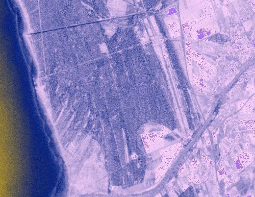
6 CHRIS acquisitions Response Corrected Images by SIRA Ltd Project ESA-EOPI Cat.1-LBR Project ID.2832 Assimilation of biophysical and biochemical variables in biochemical and hydrological models at landscape scale MZA= - 2 FZA= +55 San Rossore (Italy) 25 July 2003 MZA= - 2 o FZA= - 55 o MZA= - 2 o FZA= +36 o MZA= - 2 o FZA= 0 o MZA= - 2 o FZA=-36 o Red: 621 nm - Green: 530 nm Blue: 442 nm


7 CHRIS remote sensing campaigns SAVI image computed from CHRIS acquisition March 27, 2004 at FZA=00 SAVI image computed from CHRIS acquisition September 8, 2004 at FZA=00 PRI image computed from CHRIS acquisition March 27, 2004 at FZA=00 PRI image computed from CHRIS acquisition September 8, 2004 at FZA=00

8 CHRIS: Biogeochemical parameter retrieval and validation PRI image computed from the CHRIS acquisition on August 9, 2005 at FZA=0 0 and MZA=-6 0
 0.44 0.")
9 Daedalus TELAER campaign 10/08/2012 DAEDALUS Airborne Thematic Mapper (ATM-2) AA1278M2 (2011) on Vulcanair AP68TP-600 VIATOR GSD Begin End Heigth Air temperature 1.3 m m 26 C Four overflights over San Rossore park DAEDALUS Airborne Thematic Mapper FOV 90 IFOV Spatial corrections 1.25 mrad Roll, pitch, heading, GPS/INS Daedalus ATM wavelength (micron)


10 Daedalus TELAER campaign 10/08/2012


11 Daedalus acquisition over Boschetto site 10/08/2012 At-sensor radiance image and spectra. At-ground reflectance image and spectra.


12 Hyperion acquisition - 10/08/2012 Type: Push-broom Height: 700 Km FOV: 7.5 km Spatial resolution: 30 m Bands: 220 Spectral range: 0.4 µm 2.5 µm Spectral resolution: 10 nm San Rossore area At-sensor radiance San Rossore area At-ground reflectance Boschetto Boschetto
13 Hyperion acquisition - 10/08/2012 Spectra extracted from at-sensor radiance image over Boschetto area. Spectra extracted from at-ground reflectance image over Boschetto area.
14 Hyperion, Daedalus and in-situ acquisitions 10/08/2012 Measurements simultaneosly performed at ground, by airplane and from satellite on the same area of interest, conveniently scaled and / or processed, allowed cross-checked results.
15 Conclusions San Rossore Cal/Val test site managed by IFAC-CNR has been presented. Activities performed during CHRIS acquisitions in the framework of ESA project ESA-EOPI Cat.1-LBR Project ID.2832 have been illustrated. Activities performed during the TELAER campaign on 10/08/2012 and the simultaneous Hyperion acquisitions have been illustrated. Results coming from Daedalus and Hyperion acquisitions have been compared and discussed. Perspectives for Cal/Val activities at San Rossore in the frame of PRISMA mission.
WIDE SPECTRAL RANGE IMAGING INTERFEROMETER
 WIDE SPECTRAL RANGE IMAGING INTERFEROMETER Alessandro Barducci, Donatella Guzzi, Cinzia Lastri, Paolo Marcoionni, Vanni Nardino, Ivan Pippi CNR IFAC Sesto Fiorentino, ITALY ICSO 2012 Ajaccio 8-12/10/2012
Hyperspectral remote sensing. tool for light pollution monitoring.
 ANNALS OF GEOPHYSICS, VOL. 49, N. 1, February 2006 Hyperspectral remote sensing for light pollution monitoring Alessandro Barducci ( 1 ), Marco Benvenuti ( 2 )( 3 ), Laura Bonora ( 2 )( 3 ), Francesco
Copernicus Hyperspectral Mission
 YOUR HUB FOR GEOSPATIAL APPLICATIONS Copernicus Hyperspectral Mission Primo Workshop Nazionale Data Exploitation della missione PRISMA, precursore delle missioni iperspettrali nazionali Agenzia Spaziale
Textbook, Chapter 15 Textbook, Chapter 10 (only 10.6)
") AGOG 484/584/ APLN 551 Fall 2018 Concept definition Applications Instruments and platforms Techniques to process hyperspectral data A problem of mixed pixels and spectral unmixing Reading Textbook, Chapter
AGOG 484/584/ APLN 551 Fall 2018 Concept definition Applications Instruments and platforms Techniques to process hyperspectral data A problem of mixed pixels and spectral unmixing Reading Textbook, Chapter
CHRIS-PROBA PERFORMANCE EVALUATION: SIGNAL-TO-NOISE RATIO, INSTRUMENT EFFICIENCY AND DATA QUALITY FROM ACQUISITIONS OVER SAN ROSSORE (ITALY) TEST SITE
 TEST SITE") CHRIS-PROBA PERFORMANCE EVALUATION: SIGNAL-TO-NOISE RATIO, INSTRUMENT EFFICIENCY AND DATA QUALITY FROM ACQUISITIONS OVER SAN ROSSORE (ITALY) TEST SITE Alessandro Barducci (1), Donatella Guzzi (1), Paolo
CHRIS-PROBA PERFORMANCE EVALUATION: SIGNAL-TO-NOISE RATIO, INSTRUMENT EFFICIENCY AND DATA QUALITY FROM ACQUISITIONS OVER SAN ROSSORE (ITALY) TEST SITE Alessandro Barducci (1), Donatella Guzzi (1), Paolo
ESA UNCLASSIFIED - For Official Use
 ESA UNCLASSIFIED - For Official Use A Hyperspectral Mission for Sentinel-2 Data Product Validation of a Northern Ombrotrophic Bog Soffer R. J., Arroyo-Mora J.P., Kalacska M., White, H.P., Ifimov G., Leblanc
ALISEO: an Imaging Interferometer for Earth Observation
 ALISEO: an Imaging Interferometer for Earth Observation A. Barducci, F. Castagnoli, G. Castellini, D. Guzzi, C. Lastri, P. Marcoionni, I. Pippi CNR IFAC Sesto Fiorentino, ITALY ASSFTS14 Firenze - May 6-8,
Remote Sensing and Aerospace Technologies
 Remote Sensing and Aerospace Technologies Stefano Baronti Institute of Applied Physics Nello Carrara CNR Department of Engineering, ICT and Technologies for Energy and Transport Annual conference, CNR
Characterization of the atmospheric aerosols and the surface radiometric properties in the AGRISAR Campaign
 Characterization of the atmospheric aerosols and the surface radiometric properties in the AGRISAR Campaign V. Estellés Solar Radiation Unit Universitat de València T. Ruhtz, P. Zieger, S. Stapelberg Institute
Table (1).Operation modes and configuration in CHRIS sensor [3] Operating No of. Keyword CHRIS Sensor, De-Striping, Electronic Effect, Noise.
![Table (1).Operation modes and configuration in CHRIS sensor [3] Operating No of. Keyword CHRIS Sensor, De-Striping, Electronic Effect, Noise.](/thumbs/90/102002832.jpg "Table (1).Operation modes and configuration in CHRIS sensor [3] Operating No of. Keyword CHRIS Sensor, De-Striping, Electronic Effect, Noise.") Detection and Elimination of Striped Noise in CHRIS-PROBA Sensor Images Mohammad Reza Mobasheri Associate Professor, Remote Sensing Department, KhajeNasirToosi University of Technology, Tehran, Islamic
Detection and Elimination of Striped Noise in CHRIS-PROBA Sensor Images Mohammad Reza Mobasheri Associate Professor, Remote Sensing Department, KhajeNasirToosi University of Technology, Tehran, Islamic
EO-1 Validation in Venice, Italy: Urban Mapping, Lagoon Environment, and Bathymetry
 EO-1 Validation in Venice, Italy: Urban Mapping, Lagoon Environment, and Bathymetry Michael Abrams,, JPL, Pasadena CA Luigi Alberotanza,, CNR, Venice, Italy Stefano Pignatti,, Rosa Cavalli,, CNR- LARA,
CCDs for Earth Observation James Endicott 1 st September th UK China Workshop on Space Science and Technology, Milton Keynes, UK
 CCDs for Earth Observation James Endicott 1 st September 2011 7 th UK China Workshop on Space Science and Technology, Milton Keynes, UK Introduction What is this talk all about? e2v sensors in spectrometers
EnMAP Environmental Mapping and Analysis Program
 EnMAP Environmental Mapping and Analysis Program www.enmap.org Mathias Schneider Mission Objectives Regular provision of high-quality calibrated hyperspectral data Precise measurement of ecosystem parameters
MERIS instrument. Muriel Simon, Serco c/o ESA
 MERIS instrument Muriel Simon, Serco c/o ESA Workshop on Sustainable Development in Mountain Areas of Andean Countries Mendoza, Argentina, 26-30 November 2007 ENVISAT MISSION 2 Mission Chlorophyll case
Compact High Resolution Imaging Spectrometer (CHRIS) siraelectro-optics
 siraelectro-optics") Compact High Resolution Imaging Spectrometer (CHRIS) Mike Cutter (Mike_Cutter@siraeo.co.uk) Summary CHRIS Instrument Design Instrument Specification & Performance Operating Modes Calibration Plan Data
Compact High Resolution Imaging Spectrometer (CHRIS) Mike Cutter (Mike_Cutter@siraeo.co.uk) Summary CHRIS Instrument Design Instrument Specification & Performance Operating Modes Calibration Plan Data
IKONOS High Resolution Multispectral Scanner Sensor Characteristics
 High Spatial Resolution and Hyperspectral Scanners IKONOS High Resolution Multispectral Scanner Sensor Characteristics Launch Date View Angle Orbit 24 September 1999 Vandenberg Air Force Base, California,
COSCH STSM WG1: Summarizing coordinated and collaborative research on hyperspectral imaging devices and methods for cultural heritage documentation
 COSCH STSM WG1: Summarizing coordinated and collaborative research on hyperspectral imaging devices and methods for cultural heritage documentation E. Keats Webb University of Brighton, Science & Engineering
April - 1 May, GNSS Derived TEC Data Calibration
 2333-44 Workshop on Science Applications of GNSS in Developing Countries (11-27 April), followed by the: Seminar on Development and Use of the Ionospheric NeQuick Model (30 April-1 May) 11 April - 1 May,
ENMAP RADIOMETRIC INFLIGHT CALIBRATION, POST-LAUNCH PRODUCT VALIDATION, AND INSTRUMENT CHARACTERIZATION ACTIVITIES
 ENMAP RADIOMETRIC INFLIGHT CALIBRATION, POST-LAUNCH PRODUCT VALIDATION, AND INSTRUMENT CHARACTERIZATION ACTIVITIES A. Hollstein1, C. Rogass1, K. Segl1, L. Guanter1, M. Bachmann2, T. Storch2, R. Müller2,
R a d i o m e t r i c C a l i b r a t i o n N e t w o r k o f A u t o m a t e d I n s t r u m e n t s
 RadCalNet R a d i o m e t r i c C a l i b r a t i o n N e t w o r k o f A u t o m a t e d I n s t r u m e n t s Jeffrey Czapla-Myers* on behalf of the RadCalNet Working Group *Remote Sensing Group, College
OVERVIEW OF THE PRISMA SPACE AND GROUND SEGMENT AND ITS HYPERSPECTRAL PRODUCTS
 IEEE International Geoscience and Remote Sensing Symposium OVERVIEW OF THE PRISMA SPACE AND GROUND SEGMENT AND ITS HYPERSPECTRAL PRODUCTS Rocchina Guarini, Rosa Loizzo, Francesco Longo, Silvia Mari, Tiziana
Wind Imaging Spectrometer and Humidity-sounder (WISH): a Practical NPOESS P3I High-spatial Resolution Sensor
: a Practical NPOESS P3I High-spatial Resolution Sensor") Wind Imaging Spectrometer and Humidity-sounder (WISH): a Practical NPOESS P3I High-spatial Resolution Sensor Jeffery J. Puschell Raytheon Space and Airborne Systems, El Segundo, California Hung-Lung Huang
Wind Imaging Spectrometer and Humidity-sounder (WISH): a Practical NPOESS P3I High-spatial Resolution Sensor Jeffery J. Puschell Raytheon Space and Airborne Systems, El Segundo, California Hung-Lung Huang
Introduction of Satellite Remote Sensing
 Introduction of Satellite Remote Sensing Spatial Resolution (Pixel size) Spectral Resolution (Bands) Resolutions of Remote Sensing 1. Spatial (what area and how detailed) 2. Spectral (what colors bands)
ISIS TC Meeting. International Spaceborne Imaging Spectroscopy (ISIS) GRSS Technical Committee Meeting, 16/07/2014, IGARSS 2014
 GRSS Technical Committee Meeting, 16/07/2014, IGARSS 2014") ISIS TC Meeting International Spaceborne Imaging Spectroscopy (ISIS) GRSS Technical Committee Meeting, 16/07/2014, IGARSS 2014 Andreas Müller (DLR) Cindy Ong (CSIRO) Uta Heiden (DLR) Agenda Hyperspectral
ISIS TC Meeting International Spaceborne Imaging Spectroscopy (ISIS) GRSS Technical Committee Meeting, 16/07/2014, IGARSS 2014 Andreas Müller (DLR) Cindy Ong (CSIRO) Uta Heiden (DLR) Agenda Hyperspectral
HYPERCUBE: Hyperspectral Imaging Using a CUBESAT
 HYPERCUBE: Hyperspectral Imaging Using a CUBESAT Ian S. Robinson Senior Engineering Fellow Raytheon Certified Architect Ian.Robinson@Raytheon.com Customer Success Is Our Mission Copyright 2011 Raytheon
INF-GEO Introduction to remote sensing
 INF-GEO 4310 Introduction to remote sensing Anne Solberg (anne@ifi.uio.no) Satellites, orbits and repeat cycles Optical remote sensing Based on a tutorialt adapted d from Canadian Center for Remote Sensing,
Remote Sensing of the Environment An Earth Resource Perspective John R. Jensen Second Edition
 Remote Sensing of the Environment An Earth Resource Perspective John R. Jensen Second Edition Pearson Education Limited Edinburgh Gate Harlow Essex CM20 2JE England and Associated Companies throughout
1. INTRODUCTION. GOCI : Geostationary Ocean Color Imager
 1. INTRODUCTION The Korea Ocean Research and Development Institute (KORDI) releases an announcement of opportunity (AO) to carry out scientific research for the utilization of GOCI data. GOCI is the world
REMOTE SENSING. Topic 10 Fundamentals of Digital Multispectral Remote Sensing MULTISPECTRAL SCANNERS MULTISPECTRAL SCANNERS
 REMOTE SENSING Topic 10 Fundamentals of Digital Multispectral Remote Sensing Chapter 5: Lillesand and Keifer Chapter 6: Avery and Berlin MULTISPECTRAL SCANNERS Record EMR in a number of discrete portions
The Hyperspectral UAV (HyUAV) a novel UAV-based spectroscopy tool for environmental monitoring
 a novel UAV-based spectroscopy tool for environmental monitoring") The Hyperspectral UAV (HyUAV) a novel UAV-based spectroscopy tool for environmental monitoring R. Garzonio 1, S. Cogliati 1, B. Di Mauro 1, A. Zanin 2, B. Tattarletti 2, F. Zacchello 2, P. Marras 2 and
The Hyperspectral UAV (HyUAV) a novel UAV-based spectroscopy tool for environmental monitoring R. Garzonio 1, S. Cogliati 1, B. Di Mauro 1, A. Zanin 2, B. Tattarletti 2, F. Zacchello 2, P. Marras 2 and
Spectral Signatures. Vegetation. 40 Soil. Water WAVELENGTH (microns)
") Spectral Signatures % REFLECTANCE VISIBLE NEAR INFRARED Vegetation Soil Water.5. WAVELENGTH (microns). Spectral Reflectance of Urban Materials 5 Parking Lot 5 (5=5%) Reflectance 5 5 5 5 5 Wavelength (nm)
Spectral Signatures % REFLECTANCE VISIBLE NEAR INFRARED Vegetation Soil Water.5. WAVELENGTH (microns). Spectral Reflectance of Urban Materials 5 Parking Lot 5 (5=5%) Reflectance 5 5 5 5 5 Wavelength (nm)
3/31/03. ESM 266: Introduction 1. Observations from space. Remote Sensing: The Major Source for Large-Scale Environmental Information
 Remote Sensing: The Major Source for Large-Scale Environmental Information Jeff Dozier Observations from space Sun-synchronous polar orbits Global coverage, fixed crossing, repeat sampling Typical altitude
REVIEW OF ENMAP SCIENTIFIC POTENTIAL AND PREPARATION PHASE
 REVIEW OF ENMAP SCIENTIFIC POTENTIAL AND PREPARATION PHASE H. Kaufmann 1, K. Segl 1, L. Guanter 1, S. Chabrillat 1, S. Hofer 2, H. Bach 3, P. Hostert 4, A. Mueller 5, and C. Chlebek 6 1 Helmholtz Centre
Int n r t o r d o u d c u ti t on o n to t o Remote Sensing
 Introduction to Remote Sensing Definition of Remote Sensing Remote sensing refers to the activities of recording/observing/perceiving(sensing)objects or events at far away (remote) places. In remote sensing,
In-flight absolute calibration of an airborne wide-view multispectral imager using a reflectance-based method and its validation
 International Journal of Remote Sensing Vol. 34, No. 6, 20 March 2013, 1995 2005 In-flight absolute calibration of an airborne wide-view multispectral imager using a reflectance-based method and its validation
The studies began when the Tiros satellites (1960) provided man s first synoptic view of the Earth s weather systems.
 provided man s first synoptic view of the Earth s weather systems.") Remote sensing of the Earth from orbital altitudes was recognized in the mid-1960 s as a potential technique for obtaining information important for the effective use and conservation of natural resources.
Remote sensing of the Earth from orbital altitudes was recognized in the mid-1960 s as a potential technique for obtaining information important for the effective use and conservation of natural resources.
CORE SITE GILCHING (GERMANY) - PI ACTIVITIES IN 2003 AND AIMS FOR 2004
 - PI ACTIVITIES IN 2003 AND AIMS FOR 2004") CORE SITE GILCHING (GERMANY) - PI ACTIVITIES IN 3 AND AIMS FOR 4 Natascha Oppelt (1), Wolfram Mauser (1), Rainer Efinger (2), Peter Klotz (2) (1) University of Munich, Dept. for Earth and Environmental
CORE SITE GILCHING (GERMANY) - PI ACTIVITIES IN 3 AND AIMS FOR 4 Natascha Oppelt (1), Wolfram Mauser (1), Rainer Efinger (2), Peter Klotz (2) (1) University of Munich, Dept. for Earth and Environmental
INF-GEO Introduction to remote sensing
 INF-GEO 4310 Introduction to remote sensing Anne Solberg (anne@ifi.uio.no) Satellites, orbits and repeat cycles Optical remote sensings Based on a tutorial adapted from Canadian Center for Remote Sensing,
Technical Committee Report International Spaceborne Imaging Spectroscopy
 Slide 1 Geoscience and Remote Sensing Society Technical Committee Report International Spaceborne Imaging Spectroscopy Cindy Ong, CSIRO Andreas Mueller, DLR, Uta Heiden, DLR GRSS AdCom Meeting Washington,
FLIGHT SUMMARY REPORT
 FLIGHT SUMMARY REPORT Flight Number: 97-011 Calendar/Julian Date: 23 October 1996 297 Sensor Package: Area(s) Covered: Wild-Heerbrugg RC-10 Airborne Visible and Infrared Imaging Spectrometer (AVIRIS) Southern
SUPPLEMENTARY INFORMATION
 Making methane visible SUPPLEMENTARY INFORMATION DOI: 10.1038/NCLIMATE2877 Magnus Gålfalk, Göran Olofsson, Patrick Crill, David Bastviken Table of Contents 1. Supplementary Methods... 2 2. Supplementary
9/12/2011. Training Course Remote Sensing Basic Theory & Image Processing Methods September 2011
 Training Course Remote Sensing Basic Theory & Image Processing Methods 19 23 September 2011 Remote Sensing Platforms Michiel Damen (September 2011) damen@itc.nl 1 Overview Platforms & missions aerial surveys
Some Basic Concepts of Remote Sensing. Lecture 2 August 31, 2005
 Some Basic Concepts of Remote Sensing Lecture 2 August 31, 2005 What is remote sensing Remote Sensing: remote sensing is science of acquiring, processing, and interpreting images and related data that
Hyperspectral Imagers
 Hyperspectral Imagers Jens Nieke and Klaus I. Itten Remote Sensing Laboratories Department of Geography, University of Zurich Winterthurerstrasse 190 8057 Zurich itten@geo.unizh.ch, nieke@geo.unizh.ch
NEC s EO Sensors and Data Applications
 NEC s EO Sensors and Data Applications Second Singapore Space Symposium 30 September, 2015 Nanyang Technological University, Singapore Shimpei Kondo Space Technologies Department, Space System Division,
APEX AIRBORNE PRISM EXPERIMENT A NEW CONCEPT FOR AN AIRBORNE IMAGING SPECTROMETER *
 APEX AIRBORNE PRISM EXPERIMENT A NEW CONCEPT FOR AN AIRBORNE IMAGING SPECTROMETER * K.I. Itten, M. Schaepman e mail: apex@geo.unizh.ch Remote Sensing Laboratories, Dept. of Geography, University of Zurich
An Introduction to Remote Sensing & GIS. Introduction
 An Introduction to Remote Sensing & GIS Introduction Remote sensing is the measurement of object properties on Earth s surface using data acquired from aircraft and satellites. It attempts to measure something
Status of the CNES / MicroCarb small
 Status of the CNES / MicroCarb small satellite for CO 2 measurements D. Jouglet on behalf of the MicroCarb team (F. Buisson, D. Pradines, V. Pascal, C. Pierangelo, C. Buil, S. Gaugain, C. Deniel, F.M.
Japan's Greenhouse Gases Observation from Space
 1 Workshop on EC CEOS Priority on GHG Monitoring Japan's Greenhouse Gases Observation from Space 18 June, 2018@Ispra, Italy Masakatsu NAKAJIMA Japan Aerospace Exploration Agency Development and Operation
Hyperspectral goes to UAV and thermal
 Hyperspectral goes to UAV and thermal Timo Hyvärinen, Hannu Holma and Esko Herrala SPECIM, Spectral Imaging Ltd, Finland www.specim.fi Outline Roadmap to more compact, higher performance hyperspectral
From Proba-V to Proba-MVA
 From Proba-V to Proba-MVA Fabrizio Niro ESA Sensor Performances Products and Algorithm (SPPA) ESA UNCLASSIFIED - For Official Use Proba-V extension in the Copernicus era Proba-V was designed with the main
Application of Satellite Image Processing to Earth Resistivity Map
 Application of Satellite Image Processing to Earth Resistivity Map KWANCHAI NORSANGSRI and THANATCHAI KULWORAWANICHPONG Power System Research Unit School of Electrical Engineering Suranaree University
Kazuhiro TANAKA GCOM project team/jaxa April, 2016
 Kazuhiro TANAKA GCOM project team/jaxa April, 216 @ SPIE Asia-Pacific 216 at New Dehli, India 1 http://suzaku.eorc.jaxa.jp/gcom_c/index_j.html GCOM mission and satellites SGLI specification and IRS overview
INF-GEO Introduction to remote sensing. Anne Solberg
 INF-GEO 4310 Introduction to remote sensing Anne Solberg (anne@ifi.uio.no) Satellites, orbits and repeat cycles Optical remote sensing Useful links: Glossary for remote sensing terms: http://www.ccrs.nracn.gc.ca/glossary/index_e.php
WHAT IS NEXT IN EARTH OBSERVATION. SkyMed Mission
 WHAT IS NEXT IN EARTH OBSERVATION COSMO-SkyMed SkyMed Mission Paolo Ammendola Italian Space Agency Florence, Sept. 19, 2001 ammendola@asi asi.it THE NEEDS Market studies indicate that the value of the
MULTISPECTRAL IMAGE PROCESSING I
 TM1 TM2 337 TM3 TM4 TM5 TM6 Dr. Robert A. Schowengerdt TM7 Landsat Thematic Mapper (TM) multispectral images of desert and agriculture near Yuma, Arizona MULTISPECTRAL IMAGE PROCESSING I SENSORS Multispectral
Global hot spot monitoring with Landsat 8 and Sentinel-2. Soushi Kato Atsushi Oda Ryosuke Nakamura (AIST)
") Global hot spot monitoring with Landsat 8 and Sentinel-2 Soushi Kato Atsushi Oda Ryosuke Nakamura (AIST) Motivation for Detecting Hot Spots Hotspot detection using satellite data To monitor wildfire and
Global hot spot monitoring with Landsat 8 and Sentinel-2 Soushi Kato Atsushi Oda Ryosuke Nakamura (AIST) Motivation for Detecting Hot Spots Hotspot detection using satellite data To monitor wildfire and
Compact Multispectral and Hyperspectral Imagers based on a Wide Field of View TMA
 Compact Multispectral and Hyperspectral Imagers based on a Wide Field of View TMA M. Taccola (AOES),S. Grabarnik (AOES), L. Maresi (ESA/ESTEC), V. Moreau (AMOS), L. de Vos (OIP), Y. Versluys (OIP), G.
Remote Sensing (RS) ENY-C2005 Geoinformation in Environmental Modelling Miina Rautiainen
 ENY-C2005 Geoinformation in Environmental Modelling Miina Rautiainen") Remote Sensing (RS) ENY-C2005 Geoinformation in Environmental Modelling 25.1.2017 12.1.2015: Wildfires in central Chile Miina Rautiainen (miina.a.rautiainen@aalto.fi) Digital globe "Remote Sensing means
Remote Sensing (RS) ENY-C2005 Geoinformation in Environmental Modelling 25.1.2017 12.1.2015: Wildfires in central Chile Miina Rautiainen (miina.a.rautiainen@aalto.fi) Digital globe "Remote Sensing means
Five more talks to the wiskey tasting! Folie 1
 Five more talks to the wiskey tasting! Folie 1 EnMAP Environmental Mapping Programme Germanys Hyperspectral Earth Observation Mission Godela Roßner, Christian Chlebek, Christoph Straif, Albrecht von Bargen
An Introduction to Geomatics. Prepared by: Dr. Maher A. El-Hallaq خاص بطلبة مساق مقدمة في علم. Associate Professor of Surveying IUG
 An Introduction to Geomatics خاص بطلبة مساق مقدمة في علم الجيوماتكس Prepared by: Dr. Maher A. El-Hallaq Associate Professor of Surveying IUG 1 Airborne Imagery Dr. Maher A. El-Hallaq Associate Professor
SHALOM: SPACEBORNE HYPERSPECTRAL APPLICATIVE LAND AND OCEAN MISSION: A JOINT PROJECT OF ASI-ISA AN UPDTAE FOR 2014
 SHALOM: SPACEBORNE HYPERSPECTRAL APPLICATIVE LAND AND OCEAN MISSION: A JOINT PROJECT OF ASI-ISA AN UPDTAE FOR 2014 Eyal Ben Dor Tel Aviv University Avia Kafri Israel Space Agency (ISA) Giancarlo Varacalli
Radiometric performance of Second Generation Global Imager (SGLI) using integrating sphere
 using integrating sphere") Radiometric performance of Second Generation Global Imager (SGLI) using integrating sphere Taichiro Hashiguchi, Yoshihiko Okamura, Kazuhiro Tanaka, Yukinori Nakajima Japan Aerospace Exploration Agency
Radiometric performance of Second Generation Global Imager (SGLI) using integrating sphere Taichiro Hashiguchi, Yoshihiko Okamura, Kazuhiro Tanaka, Yukinori Nakajima Japan Aerospace Exploration Agency
HYPERSPECTRAL IMAGERY FOR SAFEGUARDS APPLICATIONS. International Atomic Energy Agency, Vienna, Austria
 HYPERSPECTRAL IMAGERY FOR SAFEGUARDS APPLICATIONS G. A. Borstad 1, Leslie N. Brown 1, Q.S. Bob Truong 2, R. Kelley, 3 G. Healey, 3 J.-P. Paquette, 3 K. Staenz 4, and R. Neville 4 1 Borstad Associates Ltd.,
AMIPAS. Advanced Michelson Interferometer for Passive Atmosphere Sounding. Concepts and Technology for Future Atmospheric Chemistry Sensors
 Earth Observation, Navigation & Science Concepts and Technology for Future Atmospheric Chemistry Sensors AMIPAS Advanced Michelson Interferometer for Passive Atmosphere Sounding Markus Melf, Winfried Posselt,
REMOVAL OF NOISES IN CHRIS/PROBA IMAGES: APPLICATION TO THE SPARC CAMPAIGN DATA
 REMOVAL OF NOISES IN CHRIS/PROBA IMAGES: APPLICATION TO THE SPARC CAMPAIGN DATA J.C. Garcia (1), J. Moreno (2) (1) DIELMO 3D S.L., Av. Benjamin Franklin 12, 46980 Paterna (Spain), Email: dielmo@dielmo.com
Ground Truth for Calibrating Optical Imagery to Reflectance
 Visual Information Solutions Ground Truth for Calibrating Optical Imagery to Reflectance The by: Thomas Harris Whitepaper Introduction: Atmospheric Effects on Optical Imagery Remote sensing of the Earth
Lecture 2. Electromagnetic radiation principles. Units, image resolutions.
 NRMT 2270, Photogrammetry/Remote Sensing Lecture 2 Electromagnetic radiation principles. Units, image resolutions. Tomislav Sapic GIS Technologist Faculty of Natural Resources Management Lakehead University
Five Years Orbit Experience of a Small Satellite Hyperspectral Imaging Mission. Mike Cutter & Martin Sweeting. AIAA Utah, August 2007
 Five Years Orbit Experience of a Small Satellite Hyperspectral Imaging Mission Mike Cutter & Martin Sweeting AIAA Utah, August 2007 SSTL - the company Surrey Satellite Technology Ltd is a private British
OVERVIEW OF KOMPSAT-3A CALIBRATION AND VALIDATION
 OVERVIEW OF KOMPSAT-3A CALIBRATION AND VALIDATION DooChun Seo 1, GiByeong Hong 1, ChungGil Jin 1, DaeSoon Park 1, SukWon Ji 1 and DongHan Lee 1 1 KARI(Korea Aerospace Space Institute), 45, Eoeun-dong,
Monitoring Natural Disasters with Small Satellites Smart Satellite Based Geospatial System for Environmental Protection
 Monitoring Natural Disasters with Small Satellites Smart Satellite Based Geospatial System for Environmental Protection Krištof Oštir, Space-SI, Slovenia Contents Natural and technological disasters Current
The Development of Imaging Spectrometry of the Coastal Ocean
 SU_8/2/2006_Davis.1 The Development of Imaging Spectrometry of the Coastal Ocean Curtiss O. Davis College of Oceanic and Atmospheric Sciences, Oregon State University, Corvallis, OR 97331 cdavis@coas.oregonstate.edu
Introduction to Remote Sensing
 Introduction to Remote Sensing Spatial, spectral, temporal resolutions Image display alternatives Vegetation Indices Image classifications Image change detections Accuracy assessment Satellites & Air-Photos
The studies began when the Tiros satellites (1960) provided man s first synoptic view of the Earth s weather systems.
 provided man s first synoptic view of the Earth s weather systems.") Remote sensing of the Earth from orbital altitudes was recognized in the mid-1960 s as a potential technique for obtaining information important for the effective use and conservation of natural resources.
Remote sensing of the Earth from orbital altitudes was recognized in the mid-1960 s as a potential technique for obtaining information important for the effective use and conservation of natural resources.
Chapter 5 Nadir looking UV measurement.
 Chapter 5 Nadir looking UV measurement. Part-II: UV polychromator instrumentation and measurements -A high SNR and robust polychromator using a 1D array detector- UV spectrometers onboard satellites have
Detectors that cover a dynamic range of more than 1 million in several dimensions
 Detectors that cover a dynamic range of more than 1 million in several dimensions Detectors for Astronomy Workshop Garching, Germany 10 October 2009 James W. Beletic Teledyne Providing the best images
FloX: A System for Automatic Long Term Measurements of Top of Canopy Sun Induced Chlorophyll Fluorescence
 FloX: A System for Automatic Long Term Measurements of Top of Canopy Sun Induced Chlorophyll Fluorescence Julitta, Tommaso; Burkart, Andreas; Rossini, Micol; Schickling, Anke; Colombo, Roberto; Rascher,
GEOMETRIC RECTIFICATION OF EUROPEAN HISTORICAL ARCHIVES OF LANDSAT 1-3 MSS IMAGERY
 GEOMETRIC RECTIFICATION OF EUROPEAN HISTORICAL ARCHIVES OF LANDSAT -3 MSS IMAGERY Torbjörn Westin Satellus AB P.O.Box 427, SE-74 Solna, Sweden tw@ssc.se KEYWORDS: Landsat, MSS, rectification, orbital model
Module 3 Introduction to GIS. Lecture 8 GIS data acquisition
 Module 3 Introduction to GIS Lecture 8 GIS data acquisition GIS workflow Data acquisition (geospatial data input) GPS Remote sensing (satellites, UAV s) LiDAR Digitized maps Attribute Data Management Data
FORMOSAT-5. - Launch Campaign-
 1 FORMOSAT-5 - Launch Campaign- FORMOSAT-5 Launch Campaign 2 FORMOSAT-5 Launch Campaign Launch Date: 2017.08.24 U.S. Pacific Time Activities 11:50-12:23 Launch Window 13:30-16:00 Reception 3 FORMOSAT-5
OPAL Optical Profiling of the Atmospheric Limb
 OPAL Optical Profiling of the Atmospheric Limb Alan Marchant Chad Fish Erik Stromberg Charles Swenson Jim Peterson OPAL STEADE Mission Storm Time Energy & Dynamics Explorers NASA Mission of Opportunity
Spotlight on Hyperspectral
 Spotlight on Hyperspectral From analyzing eelgrass beds in the Pacific Northwest to identifying pathfinder minerals for geological exploration, hyperspectral imagery and analysis is proving its worth for
ADDITIONAL SATELLITE AND SENSORS
 ADDITIONAL SATELLITE AND SENSORS A list of additional satellites and sensors, along with links to appropriate websites, is presented below. ACRIMSAT (Active Cavity Radiometer Irradiance Monitor Satellite)
How to Access EO Data
 How to Access EO Data Andrea Minchella 29 June 2009, D1L1 ESA CAT-1 EO Principal Investigator ESA PIs and Projects 1-10 projects 11-20 projects 21-40 projects 41-60 projects 61-100 projects 101-200 projects
Introduction to Satellite Remote Sensing
 Introduction to Satellite Remote Sensing Remote sensing of the Earth from orbital altitudes was recognized in the mid-1960 s as a potential technique for obtaining information important for the effective
Imaging of the equatorial ionosphere
 ANNALS OF GEOPHYSICS, VOL. 48, N. 3, June 2005 Imaging of the equatorial ionosphere Massimo Materassi ( 1 ) and Cathryn N. Mitchell ( 2 ) ( 1 ) Istituto dei Sistemi Complessi, CNR, Sesto Fiorentino (FI),
Basic Hyperspectral Analysis Tutorial
 Basic Hyperspectral Analysis Tutorial This tutorial introduces you to visualization and interactive analysis tools for working with hyperspectral data. In this tutorial, you will: Analyze spectral profiles
MR-i. Hyperspectral Imaging FT-Spectroradiometers Radiometric Accuracy for Infrared Signature Measurements
 MR-i Hyperspectral Imaging FT-Spectroradiometers Radiometric Accuracy for Infrared Signature Measurements FT-IR Spectroradiometry Applications Spectroradiometry applications From scientific research to
typical spectral signatures of photosynthetically active and non-photosynthetically active vegetation (Beeri et al., 2007)
") typical spectral signatures of photosynthetically active and non-photosynthetically active vegetation (Beeri et al., 2007) Xie, Y. et al. J Plant Ecol 2008 1:9-23; doi:10.1093/jpe/rtm005 Copyright restrictions
typical spectral signatures of photosynthetically active and non-photosynthetically active vegetation (Beeri et al., 2007) Xie, Y. et al. J Plant Ecol 2008 1:9-23; doi:10.1093/jpe/rtm005 Copyright restrictions
MR-i. Hyperspectral Imaging FT-Spectroradiometers Radiometric Accuracy for Infrared Signature Measurements
 MR-i Hyperspectral Imaging FT-Spectroradiometers Radiometric Accuracy for Infrared Signature Measurements FT-IR Spectroradiometry Applications Spectroradiometry applications From scientific research to
Airborne hyperspectral data over Chikusei
 SPACE APPLICATION LABORATORY, THE UNIVERSITY OF TOKYO Airborne hyperspectral data over Chikusei Naoto Yokoya and Akira Iwasaki E-mail: {yokoya, aiwasaki}@sal.rcast.u-tokyo.ac.jp May 27, 2016 ABSTRACT Airborne
746A27 Remote Sensing and GIS. Multi spectral, thermal and hyper spectral sensing and usage
 746A27 Remote Sensing and GIS Lecture 3 Multi spectral, thermal and hyper spectral sensing and usage Chandan Roy Guest Lecturer Department of Computer and Information Science Linköping University Multi
Ge111A Remote Sensing and GIS Lecture
 Ge111A Remote Sensing and GIS Lecture Remote Sensing - many different geophysical data sets. We concentrate on the following: Imagery (optical and radar) Topography Geographical Information Systems (GIS)
Microwave Sensors Subgroup (MSSG) Report
 Report") Microwave Sensors Subgroup (MSSG) Report Feb 17-20, 2014, ESA ESRIN, Frascati, Italy DONG, Xiaolong, MSSG Chair National Space Science Center Chinese Academy of Sciences (MiRS,NSSC,CAS) Email: dongxiaolong@mirslab.cn
Microwave Sensors Subgroup (MSSG) Report Feb 17-20, 2014, ESA ESRIN, Frascati, Italy DONG, Xiaolong, MSSG Chair National Space Science Center Chinese Academy of Sciences (MiRS,NSSC,CAS) Email: dongxiaolong@mirslab.cn
A CONCEPT FOR A REGIONAL COASTAL ZONE MISSION
 A CONCEPT FOR A REGIONAL COASTAL ZONE MISSION J. Nieke a, b, A. Neumann b, H. Schwarzer b, B. Penné c a NASDA, Earth Observation Research Center, 1-8-10, Harumi, 104-6023 Tokyo, Japan b DLR, German Aerospace
Satellite Remote Sensing: Earth System Observations
 Satellite Remote Sensing: Earth System Observations Land surface Water Atmosphere Climate Ecosystems 1 EOS (Earth Observing System) Develop an understanding of the total Earth system, and the effects of
Multispectral Scanners for Wildland Fire Assessment NASA Ames Research Center Earth Science Division. Bruce Coffland U.C.
 Multispectral Scanners for Wildland Fire Assessment NASA Earth Science Division Bruce Coffland U.C. Santa Cruz Slide Fire Burn Area (MASTER/B200) R 2.2um G 0.87um B 0.65um Airborne Science & Technology
1 W. Philpot, Cornell University The Digital Image
 1 The Digital Image DEFINITION: A grayscale image is a single-valued function of 2 variables: ff(xx 1, xx 2 ). Notes: A gray scale image is a single-valued function of two spatial variables, ff(xx 11,
APPLICATION OF HYPERSPECTRAL REMOTE SENSING IN TARGET DETECTION AND MAPPING USING FIELDSPEC ASD IN UDAYGIRI (M.P.)
") 1 International Journal of Advance Research, IJOAR.org Volume 1, Issue 3, March 2013, Online: APPLICATION OF HYPERSPECTRAL REMOTE SENSING IN TARGET DETECTION AND MAPPING USING FIELDSPEC ASD IN UDAYGIRI
1 International Journal of Advance Research, IJOAR.org Volume 1, Issue 3, March 2013, Online: APPLICATION OF HYPERSPECTRAL REMOTE SENSING IN TARGET DETECTION AND MAPPING USING FIELDSPEC ASD IN UDAYGIRI
HyperSTREEGO A Reactive Multispectral Optical Payload for Small Satellites
 Driving Innovation in Space Optics and Optical Systems HyperSTREEGO A Reactive Multispectral Optical Payload for Small Satellites Giovanni Bianucci 1 Introduction Demand for remote sensing data is increasing