smos: payload Mark Drinkwater, Kevin McMullan, Joel Marti & Michael Brown Directorate of Earth Observation, ESTEC, Noordwijk, The Netherlands
|
|
|
- Rosalind Osborne
- 5 years ago
- Views:
Transcription
1
2 smos: payload STAR IN THE SKY The SMOS payload: MIRAS Mark Drinkwater, Kevin McMullan, Joel Marti & Michael Brown Directorate of Earth Observation, ESTEC, Noordwijk, The Netherlands Manuel Martín-Neira, Willy Rits, Sten Ekholm & Jerzy Lemanczyk Directorate of Technical and Quality Management, ESTEC, Noordwijk, The Netherlands Yann Kerr CESBIO, Toulouse, France Jordi Font SMOS-BEC, Institut de Ciències del Mar, CSIC, Barcelona, Spain Michael Berger Directorate of Earth Observation, ESRIN, Frascati, Italy MIRAS is more than just the payload of SMOS. It is a radio telescope pointed towards Earth, an instrument that has challenged the fundamental theories of radio astronomy, and made a major contribution to science even before being launched. Built by a consortium of over 20 European companies led by EADS-CASA Espacio (E), MIRAS is the single instrument carried on board ESA s Soil Moisture and Ocean Salinity (SMOS) mission. MIRAS stands for the Microwave Imaging Radiometer with Aperture Synthesis. The theory behind microwave remote sensing of soil moisture and ocean salinity is based on the significant contrast between the electromagnetic properties of pure liquid water and dry soil, and pure water and saline water respectively. As the proportion of water in the soilwater mixture (or proportion of salt in the saline mixture) European Space Agency Bulletin 137 February

3 earth observation increases, this change is detectable by microwave sensors in terms of the emission of microwave energy, called the microwave brightness temperature of the surface. For practical soil moisture and ocean salinity applications, using longer microwave wavelengths offers the advantage that the atmosphere, or vegetation cover, are more transparent to the upwelling signal from the surface. The radiation emitted by Earth and observed in the L-band microwave range by SMOS, however, is not only a function of soil moisture and ocean salinity. To ensure that the data derived from the SMOS mission are correctly converted into the appropriate units of moisture and salinity, many other potential perturbation or contamination effects on the signal must be carefully accounted for. MIRAS correlations inside ESA s Maxwell anechoic chamber (top blue line, predicted values from radio astronomy; bottom blue line, Corbella equation prediction; measurements in red) Visibility of an empty chamber at 293K A truly novel instrument For optimum results, SMOS will measure the microwave radiation emitted from Earth s surface within the L-band, around a central frequency of GHz. This microwave frequency is protected from man-made emissions and provides the greatest sensitivity to soil moisture and ocean salinity, while minimising disturbances due the weather, atmosphere and vegetation cover above the surface. SMOS payload industrial consortium Antenna separation normalised to wavelenght The most challenging requirements for the mission are to be able to achieve good radiometric accuracy and stability, repeated global coverage over a short time interval, coupled with the ability to capture regional details in the quantities of interest. Observations at this frequency and with this spatial resolution would normally require an extremely large antenna (at least 8 m diameter) to achieve the desired results. Unfortunately, this approach would lead to an extremely large payload, too big for the size of satellite available. MIRAS s truly novel approach makes use of techniques used in radio astronomy, called aperture synthesis, to create a large aperture from a two-dimensional array of small passive microwave radiometers, and interferometry to obtain the required spatial resolution and coverage. Similar to the very large baseline interferometers (VLBI) used on Earth, the SMOS concept relies on a Y-shaped array of 69 elementary antennas, deployed in space, which are equivalent to a classical antenna over 8 m in diameter. This will be the first ever two-dimensional interferometric radiometer in space. From a mean altitude of 755 km, SMOS will see a considerable area of Earth s surface at any point along its orbit. The interferometric measurements will result in images from within a hexagon-like field of view about 1000 km across, enabling total coverage of Earth in under three days Instrument concept MIRAS has changed the basic equation of radio astronomy. In theory, if Earth was enclosed in a gigantic sphere 18

 Three NIRs each consist of two LICEFs connected to a noise injection control unit (NIC).")
4 MIRAS subsystems smos: payload LICEF The 66 Light-weight Cost-Effective (LICEF) receivers are the eyes of MIRAS. They are very sensitive total power radiometric receivers integrated with an antenna which captures radiation in both polarisations in the radio astronomy protected band of MHz. Weighing only 1 kg and consuming 1W power, these receivers filter out any signals outside the protected band and are extremely clean, i.e. very low self-noise and no internal interference. Noise Injection Radiometers (NIR) Three NIRs each consist of two LICEFs connected to a noise injection control unit (NIC). Noise injection radiometers are more stable than total power radiometers like the LICEFs. The NIRs are used to calibrate the whole array using the on-board calibration system (CAS). A LICEF radiometric receiver: the eyes of MIRAS Calibration System (CAS) The on-board calibration system provides a correlated noise reference signal to calibrate the amplitude and phase of the LICEF receivers. MOHA The transmission of the master clock signal, the local oscillator and the received digitised data is performed with an optical-fibre digital network called MOHA. This has advantages over classical electrical interfaces, such as: (a) low electromagnetic emissions, vitally important for MIRAS, (b) good phase stability by comparison with coaxial cables, over temperature and when bent, (c) insensitivity to ground differential voltages and (d) lightweight and very flexible. MOHA consists of a number of optical splitters, electrooptical converters and optical fibres. Overall, MOHA contains 74 solidstate lasers, 168 optical-receiver diodes and approximately 800 m of optical fibre cable. Correlator and Control Unit (CCU) This is the instrument central computer that correlates the data received through the MOHA optical harness from all 66 LICEFs and NIR receivers. The CCU also monitors 12 thermal control loops to ensure a thermal gradient of less than 1 C across any arm segment and 6 C maximum gradient between any pair of LICEFs. Control and Monitoring Node (CMN) The CMN acts as a remote terminal of the CCU. Its main functions are: handling commands from and telemetries to the CCU; analogue telemetries acquisitions like physical temperatures and LICEF voltages; control of the LICEF polarisation and calibration; control of the CAS noise injection level switch; distributed thermal control (heaters); secondary power supply to segment units (LICEF, NIR and CAS); finally, the generation and distribution of the 1396 MHz local oscillator signal to all LICEFs. How each LICEF fits on the arms of MIRAS European Space Agency Bulletin 137 February

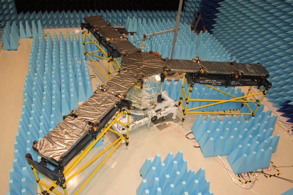
5 earth observation of microwave absorbing material, at uniform physical temperature (a black body ), radio astronomers would not be able to image such a simple uniform target. MIRAS broke this barrier apart. MIRAS is based on the Corbella equation, which is a fundamental variation to the Van-Cittert Zernike theorem used in radio astronomy. The Corbella equation relates the behaviour of a radiometer inside a black body with another well-known microwave theorem, the Bosma theorem. The Corbella equation was derived by the Polytechnic University of Catalonia (E) during the pre-development activities that led to the SMOS mission and can be considered as a major contribution of SMOS to science already before being launched. MIRAS captures the noise radiated by the target through its small apertures and performs the cross-correlation of the MIRAS has changed the basic equation of radio astronomy. To fit on the launcher, the MIRAS arms are divided into three segments separate d by spring-hinged deployment lines. The deployment of the three arms happens simultaneously thanks to a speed regulator in the root hinges and a system The Corbella equation signals from all possible pairs ( baselines ) of antennas. This set of cross-correlations constitutes the raw measurements provided by the instrument. According to the Corbella equation, each cross-correlation is a Fourier component of the difference (contrast) between the brightness temperature of the target and the physical temperature of the instrument. No contrast leads to zero correlations, which is the case of an interferometer enclosed in a black body in thermal equilibrium conditions (Bosma theorem). So MIRAS does not measure the brightness temperature of the scene directly, but its Fourier spectrum. It is therefore necessary to apply an inverse transformation to the basic measurements of SMOS to retrieve an image. System nonidealities mean that the relationship between target and cross-correlations is not an exact Fourier transform, and the image reconstruction has to take this into account. MIRAS mechanical features MIRAS s unusual three-pointed star shape is due to the hexagonal sampling that the instrument performs of the spectrum of the image. The small apertures (69 in total) are arranged along three arms evenly spaced at 120. This represents a saving of 15% in the required number of receivers by comparison with rectangular sampling (which would lead to a cross shape instead of a star). Less visible to the eye is MIRAS s main architectural feature: the replication of the same basic electrical, mechanical and thermal functions across its large array. The modularity of its design has been the key to split critical requirements across different subsystems optimally, to ease their manufacturing and integration, and to allow instrument testing on ground. of pulleys and ropes interconnecting this to the two outer hinges. The deployment takes about three and a half minutes. MIRAS during its assembly and integration 20


6 the payload. The other sides accommodate the X-band transmitter to send the data to ground and the star tracker to determine the pointing of the instrument accurately. The top and bottom bases of the hub prism serve as trays to which attach the electronic equipment. The hub interface to PROTEUS is through fixing points at the four corners of the platform upper side. smos: payload The thermal control in MIRAS is designed to minimise the temperature differences across receivers. This is achieved by placing all these units on thermal doublers actively controlled in temperature by heaters. The temperature sensors are built into the receivers themselves, providing the feedback for the thermal control software in the on-board computer. Externally, the temperature equalisation of the receivers is assisted by a radio-transparent foil placed on all the antennas. Arm deployment test The arms are made of carbon-fibre reinforced polymer with some aluminium-reinforced areas near the deployment mechanisms. The carbon fibre ensures a high thermal structural stability, important for keeping a constant distance between L-band receivers during the mission. The width of the arms was chosen to reject signals coming from behind the array as well as to host the electronic boxes and harness inside. The arms fold flat over three of the sides of a 1.2 m high strutted hexagonal prism that constitutes the hub of MIRAS electronics The level of power radiated by Earth that can be collected within the protected L-band (brightness temperature) is very low. Hence the receivers of MIRAS are highly sensitive microwave receivers (LICEFs) that amplify the signal several billions of times up to detectable levels. The digital output signals from the receivers are sent to a central correlator through an optical harness (MOHA). Optical fibres have proved essential in achieving MIRAS s formidable performance, absent of any bias in the majority of the correlations. Errors caused by internal signals leaking towards the very sensitive receivers are difficult, if not impossible, to calibrate out properly given the tight scientific requirements. Optical fibres do not radiate nor pick up any electrical signal, leading to the verified result of extremely clean measurements. SMOS is the first mission on which ESA will launch an optical harness into space. MIRAS inside ESA s Large Space Simulator undergoing thermal-vacuum tests European Space Agency Bulletin 137 February


7 earth observation Interferometry in remote sensing The origins of radio astronomy date back to the 1940s and 50s, but applications to Earth observation were only suggested in the late 1970s by the University of Berne. It was practically proposed in the 1980s by engineers at NASA s Goddard Space Flight Center in collaboration with the University of Massachusetts at Amherst, with the objective of mapping Earth s soil moisture and ocean salinity, two important geophysical parameters never measured before at global scale. AMIRAS: the Airborne MIRAS demonstrator on the HUT Skyvan The first interferometric radiometer built had a synthetic beam in only one dimension, using the real aperture antenna pattern in the other. This was NASA s Electronically Steered Thinned Array Radiometer (ESTAR), an aircraft demonstrator of such a hybrid instrument. Subsequent developments followed elsewhere with different variations such as using the motion of the platform to reduce in the required number of receivers, this being equivalent to the use of Earth rotation in radio astronomy. Aperture synthesis in two dimensions was developed in Europe during the 1990s. The Technical University of Denmark constructed a laboratory demonstrator and ESA started the research for the spaceborne L-band MIRAS radiometer. ESA s study involved French scientists at the Centre d Etudes Spatiales de la Biosphère (CESBIO), who had already started the research in this area, and benefited with the participation of radio astronomers from the Observatoire du Midi Pyrenees. The Polytechnic University of Catalonia (UPC) in Barcelona played an important role in defining the requirements and calibration strategy for MIRAS. Even more crucial was UPC s research on the completed ESA MIRAS demonstrator, which led to the Corbella equation in early 2003, a fundamental correction to the formulation used by radio astronomers. The Helsinki University of Technology (HUT) manufactured the HUT-2D, the first airborne two-dimensional aperture synthesis radiometer to provide good quality images of Earth surface. The calibration strategy of SMOS was first tested on HUT-2D. In 1999 the SMOS mission was selected by ESA as the second Earth Explorer Opportunity Mission, carrying MIRAS as the only payload instrument. In 2009, SMOS will demonstrate these new techniques and pave the way for applications in other areas. In fact, aperture synthesis has been proposed from geostationary orbit and higher frequency interferometers are now considered viable for Earth observation satellites flying in low Earth orbit. Several other ground-based and airborne microwave interferometric radiometers have been developed by different groups around the world, such as NASA s ESTAR-2D, JPL and ESA geostationary sounder demonstrators, and the C- and X-band interferometers of the Chinese Centre of Space Science and Application Research. Helsinki University of Technology s HUT-2D interferometer 22
1. SMOS Status 1.1 Payload 1.2 Platform 1.3 Satellite 1.4 Launcher 1.5 FOS 1.6 DPGS 2. Other Developments 3. Future (Near & Far) 4.
 4.") 1. SMOS Status 1.1 Payload 1.2 Platform 1.3 Satellite 1.4 Launcher 1.5 FOS 1.6 DPGS 2. Other Developments 3. Future (Near & Far) 4. Schedule 1 1.1 Payload General: Structural / Thermal Model test campaigns
1. SMOS Status 1.1 Payload 1.2 Platform 1.3 Satellite 1.4 Launcher 1.5 FOS 1.6 DPGS 2. Other Developments 3. Future (Near & Far) 4. Schedule 1 1.1 Payload General: Structural / Thermal Model test campaigns
Improvement of Antenna System of Interferometric Microwave Imager on WCOM
 Progress In Electromagnetics Research M, Vol. 70, 33 40, 2018 Improvement of Antenna System of Interferometric Microwave Imager on WCOM Aili Zhang 1, 2, Hao Liu 1, *,XueChen 1, Lijie Niu 1, Cheng Zhang
SMOS Payload Performance
 SMOS Payload Performance Manuel Martin-Neira, Michael Brown SM-OS Project European Space Agency Josep Closa EADS-CASA Espacio and contributions from: UPC and DEIMOS SMOS project teams 1/33 Contents: -
Earth Exploration-Satellite Service (EESS) - Passive Spaceborne Remote Sensing
 - Passive Spaceborne Remote Sensing") Earth Exploration-Satellite Service (EESS) - Passive Spaceborne Remote Sensing John Zuzek Vice-Chairman ITU-R Study Group 7 ITU/WMO Seminar on Spectrum & Meteorology Geneva, Switzerland 16-17 September
Earth Exploration-Satellite Service (EESS) - Passive Spaceborne Remote Sensing John Zuzek Vice-Chairman ITU-R Study Group 7 ITU/WMO Seminar on Spectrum & Meteorology Geneva, Switzerland 16-17 September
GeoSTAR A New Approach for a Geostationary Microwave Sounder
 GeoSTAR A New Approach for a Geostationary Microwave Sounder Bjorn Lambrigtsen 13th International TOVS Study Jet Propulsion Laboratory California Institute of Technology Conference Ste. Adèle, Canada October
Image Simulator for One Dimensional Synthetic Aperture Microwave Radiometer
 524 Progress In Electromagnetics Research Symposium 25, Hangzhou, China, August 22-26 Image Simulator for One Dimensional Synthetic Aperture Microwave Radiometer Qiong Wu, Hao Liu, and Ji Wu Center for
IEEE TRANSACTIONS ON GEOSCIENCE AND REMOTE SENSING, VOL. 35, NO. 1, JANUARY by [2], [4] (1)
![IEEE TRANSACTIONS ON GEOSCIENCE AND REMOTE SENSING, VOL. 35, NO. 1, JANUARY by [2], [4] (1)](/thumbs/83/88186747.jpg "IEEE TRANSACTIONS ON GEOSCIENCE AND REMOTE SENSING, VOL. 35, NO. 1, JANUARY by [2], [4] (1)") IEEE TRANSACTIONS ON GEOSCIENCE AND REMOTE SENSING, VOL. 35, NO. 1, JANUARY 1997 183 The Processing of Hexagonally Sampled Signals with Standard Rectangular Techniques: Application to 2 D Large Aperture
IEEE TRANSACTIONS ON GEOSCIENCE AND REMOTE SENSING, VOL. 35, NO. 1, JANUARY 1997 183 The Processing of Hexagonally Sampled Signals with Standard Rectangular Techniques: Application to 2 D Large Aperture
Passive Microwave Sensors LIDAR Remote Sensing Laser Altimetry. 28 April 2003
 Passive Microwave Sensors LIDAR Remote Sensing Laser Altimetry 28 April 2003 Outline Passive Microwave Radiometry Rayleigh-Jeans approximation Brightness temperature Emissivity and dielectric constant
Microwave - the SMOS Mission
 Microwave - the SMOS Mission Prof. Bob Su prepared by Monday 29 June 2009, D1L3a Part 1 SMOS MIRAS SMOS - Soil Moisture Ocean Salinity MIRAS - Microwave Imaging Radiometer using Aperture Synthesis Passive
THE SOIL Moisture and Ocean Salinity (SMOS) mission
 mission") IEEE TRANSACTIONS ON GEOSCIENCE AND REMOTE SENSING, VOL. 47, NO. 9, SEPTEMBER 2009 3123 On-Ground Characterization of the SMOS Payload Ignasi Corbella, Senior Member, IEEE, Francesc Torres, Senior Member,
IEEE TRANSACTIONS ON GEOSCIENCE AND REMOTE SENSING, VOL. 47, NO. 9, SEPTEMBER 2009 3123 On-Ground Characterization of the SMOS Payload Ignasi Corbella, Senior Member, IEEE, Francesc Torres, Senior Member,
Dave McGinnis Rich Kelley Jean Pla NESDIS spectrum manager Alion Science CNES Silver Spring, MD Suitland, MD Toulouse, FR
 Dave McGinnis Rich Kelley Jean Pla NESDIS spectrum manager Alion Science CNES Silver Spring, MD 20910 Suitland, MD 20746 Toulouse, FR New ITU R report Identification of degradation due to interference
Microwave Sensors Subgroup (MSSG) Report
 Report") Microwave Sensors Subgroup (MSSG) Report Feb 17-20, 2014, ESA ESRIN, Frascati, Italy DONG, Xiaolong, MSSG Chair National Space Science Center Chinese Academy of Sciences (MiRS,NSSC,CAS) Email: dongxiaolong@mirslab.cn
Microwave Sensors Subgroup (MSSG) Report Feb 17-20, 2014, ESA ESRIN, Frascati, Italy DONG, Xiaolong, MSSG Chair National Space Science Center Chinese Academy of Sciences (MiRS,NSSC,CAS) Email: dongxiaolong@mirslab.cn
1.6 Beam Wander vs. Image Jitter
 8 Chapter 1 1.6 Beam Wander vs. Image Jitter It is common at this point to look at beam wander and image jitter and ask what differentiates them. Consider a cooperative optical communication system that
Satellite Testing. Prepared by. A.Kaviyarasu Assistant Professor Department of Aerospace Engineering Madras Institute Of Technology Chromepet, Chennai
 Satellite Testing Prepared by A.Kaviyarasu Assistant Professor Department of Aerospace Engineering Madras Institute Of Technology Chromepet, Chennai @copyright Solar Panel Deployment Test Spacecraft operating
MERLIN Mission Status
 MERLIN Mission Status CNES/illustration David DUCROS, 2016 G. Ehret 1, P. Bousquet 2, B. Millet 3, M. Alpers 1, C. Deniel 3, A. Friker 1, C. Pierangelo 3 1 Deutsches Zentrum für Luft- und Raumfahrt (DLR)
Interferometry I Parkes Radio School Jamie Stevens ATCA Senior Systems Scientist
 Interferometry I Parkes Radio School 2011 Jamie Stevens ATCA Senior Systems Scientist 2011-09-28 References This talk will reuse material from many previous Radio School talks, and from the excellent textbook
Microwave Sensors Subgroup (MSSG) Report
 Report") Microwave Sensors Subgroup (MSSG) Report CEOS WGCV-35 May 13-17, 2013, Shanghai, China DONG, Xiaolong, MSSG Chair CAS Key Laboratory of Microwave Remote Sensing National Space Science Center Chinese Academy
Microwave Sensors Subgroup (MSSG) Report CEOS WGCV-35 May 13-17, 2013, Shanghai, China DONG, Xiaolong, MSSG Chair CAS Key Laboratory of Microwave Remote Sensing National Space Science Center Chinese Academy
Industry Day of the Copernicus Sentinel-5 and Jason-CS Projects
 Industry Day of the Copernicus Sentinel-5 and Jason-CS Projects With the present announcement, the European Space Agency and Astrium GmbH Satellites (Germany) inform the EMITS Users (European Companies
Miguel A. Aguirre. Introduction to Space. Systems. Design and Synthesis. ) Springer
 Springer") Miguel A. Aguirre Introduction to Space Systems Design and Synthesis ) Springer Contents Foreword Acknowledgments v vii 1 Introduction 1 1.1. Aim of the book 2 1.2. Roles in the architecture definition
Miguel A. Aguirre Introduction to Space Systems Design and Synthesis ) Springer Contents Foreword Acknowledgments v vii 1 Introduction 1 1.1. Aim of the book 2 1.2. Roles in the architecture definition
National Aeronautics and Space Administration Jet Propulsion Laboratory California Institute of Technology
 QuikSCAT Mission Status QuikSCAT Follow-on Mission 2 QuikSCAT instrument and spacecraft are healthy, but aging June 19, 2009 will be the 10 year launch anniversary We ve had two significant anomalies during
CoSMOS: Performance of Kurtosis Algorithm for Radio Frequency Interference Detection and Mitigation
 Downloaded from orbit.dtu.dk on: Jul 4, 18 CoSMOS: Performance of Kurtosis Algorithm for Radio Frequency Interference Detection and Mitigation Misra, Sidharth; Kristensen, Steen Savstrup; Skou, Niels;
Dual Polarized Radiometers DPR Series RPG DPR XXX. Applications. Features
 Dual Polarized Radiometers Applications Soil moisture measurements Rain observations Discrimination of Cloud Liquid (LWC) and Rain Liquid (LWR) Accurate LWP measurements during rain events Cloud physics
MEthane Remote sensing LIdar mission COPUOS, Vienna June 2013
 CNES CNES/Photon/ill.Michel Regy, 2013 MEthane Remote sensing LIdar mission COPUOS, Vienna 12.-21. June 2013 1 MERLIN COPUOS, Vienna 12.-21. June 2013 CNES Climate Change Temperature Increase over the
Lab Report 3: Speckle Interferometry LIN PEI-YING, BAIG JOVERIA
 Lab Report 3: Speckle Interferometry LIN PEI-YING, BAIG JOVERIA Abstract: Speckle interferometry (SI) has become a complete technique over the past couple of years and is widely used in many branches of
Wireless Power Transmission of Solar Energy from Space to Earth Using Microwaves
 Wireless Power Transmission of Solar Energy from Space to Earth Using Microwaves Raghu Amgothu Contract Lecturer in ECE Dept., Government polytechnic Warangal Abstract- In the previous stages, we are studying
Signal Flow & Radiometer Equation. Aletha de Witt AVN-Newton Fund/DARA 2018 Observational & Technical Training HartRAO
 Signal Flow & Radiometer Equation Aletha de Witt AVN-Newton Fund/DARA 2018 Observational & Technical Training HartRAO Understanding Radio Waves The meaning of radio waves How radio waves are created -
Sub-millimeter Wave Planar Near-field Antenna Testing
 Sub-millimeter Wave Planar Near-field Antenna Testing Daniёl Janse van Rensburg 1, Greg Hindman 2 # Nearfield Systems Inc, 1973 Magellan Drive, Torrance, CA, 952-114, USA 1 drensburg@nearfield.com 2 ghindman@nearfield.com
Fringe-washing function calibration in aperture synthesis microwave radiometry
 RADIO SCIENCE, VOL. 38, NO., 103, doi:10.109/00rs00695, 003 Fringe-washing function calibration in aperture synthesis microwave radiometry R. Butora Laboratory of Space Technology, Helsinki University
Unit 1.5 Waves. The number waves per second. 1 Hz is 1waves per second. If there are 40 waves in 10 seconds then the frequency is 4 Hz.
 Unit 1.5 Waves Basic information Transverse: The oscillations of the particles are at right angles (90 ) to the direction of travel (propagation) of the wave. Examples: All electromagnetic waves (Light,
PASSIVE MICROWAVE PROTECTION
 PASSIVE MICROWAVE PROTECTION RESULTS OF WRC-07 DISASTER MANGEMENT FUTURE WORK FOR WRC-11, RFI INTERFERENCE ON SATELLITE PASSIVE OBSERVATIONS Jean PLA CNES, Toulouse, France Frequency manager 1 Agenda items
Design and Development of a Ground-based Microwave Radiometer System
 PIERS ONLINE, VOL. 6, NO. 1, 2010 66 Design and Development of a Ground-based Microwave Radiometer System Yu Zhang 1, 2, Jieying He 1, 2, and Shengwei Zhang 1 1 Center for Space Science and Applied Research,
Compact High Resolution Imaging Spectrometer (CHRIS) siraelectro-optics
 siraelectro-optics") Compact High Resolution Imaging Spectrometer (CHRIS) Mike Cutter (Mike_Cutter@siraeo.co.uk) Summary CHRIS Instrument Design Instrument Specification & Performance Operating Modes Calibration Plan Data
Compact High Resolution Imaging Spectrometer (CHRIS) Mike Cutter (Mike_Cutter@siraeo.co.uk) Summary CHRIS Instrument Design Instrument Specification & Performance Operating Modes Calibration Plan Data
AGRON / E E / MTEOR 518 Laboratory
 AGRON / E E / MTEOR 518 Laboratory Brian Hornbuckle, Nolan Jessen, and John Basart April 5, 2018 1 Objectives In this laboratory you will: 1. identify the main components of a ground based microwave radiometer
Copernicus Introduction Lisbon, Portugal 13 th & 14 th February 2014
 Copernicus Introduction Lisbon, Portugal 13 th & 14 th February 2014 Contents Introduction GMES Copernicus Six thematic areas Infrastructure Space data An introduction to Remote Sensing In-situ data Applications
746A27 Remote Sensing and GIS
 746A27 Remote Sensing and GIS Lecture 1 Concepts of remote sensing and Basic principle of Photogrammetry Chandan Roy Guest Lecturer Department of Computer and Information Science Linköping University What
RADIOMETRIC TRACKING. Space Navigation
 RADIOMETRIC TRACKING Space Navigation October 24, 2016 D. Kanipe Space Navigation Elements SC orbit determination Knowledge and prediction of SC position & velocity SC flight path control Firing the attitude
RESERVOIR MONITORING USING RADAR SATELLITES
 RESERVOIR MONITORING USING RADAR SATELLITES Alain Arnaud, Johanna Granda, Geraint Cooksley ALTAMIRA INFORMATION S.L., Calle Córcega 381-387, E-08037 Barcelona, Spain. Key words: Reservoir monitoring, InSAR,
Microwave Remote Sensing
 Provide copy on a CD of the UCAR multi-media tutorial to all in class. Assign Ch-7 and Ch-9 (for two weeks) as reading material for this class. HW#4 (Due in two weeks) Problems 1,2,3 and 4 (Chapter 7)
RPG-MWR-PRO-TN Page 1 / 12 Radiometer Physics GmbH
 Applications Tropospheric profiling of temperature, humidity and liquid water High-resolution boundary layer temperature profiles, better resolution than balloons Input for weather and climate models (data
Why Single Dish? Why Single Dish? Darrel Emerson NRAO Tucson
 Why Single Dish? Darrel Emerson NRAO Tucson Why Single Dish? What's the Alternative? Comparisons between Single-Dish, Phased Array & Interferometers Advantages and Disadvantages of Correlation Interferometer
Acknowledgment. Process of Atmospheric Radiation. Atmospheric Transmittance. Microwaves used by Radar GMAT Principles of Remote Sensing
 GMAT 9600 Principles of Remote Sensing Week 4 Radar Background & Surface Interactions Acknowledgment Mike Chang Natural Resources Canada Process of Atmospheric Radiation Dr. Linlin Ge and Prof Bruce Forster
Microwave Remote Sensing (1)
") Microwave Remote Sensing (1) Microwave sensing encompasses both active and passive forms of remote sensing. The microwave portion of the spectrum covers the range from approximately 1cm to 1m in wavelength.
Microwave Remote Sensing (1) Microwave sensing encompasses both active and passive forms of remote sensing. The microwave portion of the spectrum covers the range from approximately 1cm to 1m in wavelength.
Design of a Free Space Optical Communication Module for Small Satellites
 Design of a Free Space Optical Communication Module for Small Satellites Ryan W. Kingsbury, Kathleen Riesing Prof. Kerri Cahoy MIT Space Systems Lab AIAA/USU Small Satellite Conference August 6 2014 Problem
RADIOMETRIC TRACKING. Space Navigation
 RADIOMETRIC TRACKING Space Navigation Space Navigation Elements SC orbit determination Knowledge and prediction of SC position & velocity SC flight path control Firing the attitude control thrusters to
Istanbul Technical University Faculty of Aeronautics and Astronautics Space Systems Design and Test Laboratory
 Title: Space Advertiser (S-VERTISE) Primary POC: Aeronautics and Astronautics Engineer Hakan AYKENT Organization: Istanbul Technical University POC email: aykent@itu.edu.tr Need Worldwide companies need
Advanced Radiometer for Sea Surface Temperature Observations
 Advanced Radiometer for Sea Surface Temperature Observations Harp Technologies Oy: J. Kainulainen, J. Uusitalo, J. Lahtinen TERMA A/S: M. Hansen, M. Pedersen Finnish Remote Sensing Days 2014 Finnish Meteorological
remote sensing? What are the remote sensing principles behind these Definition
 Introduction to remote sensing: Content (1/2) Definition: photogrammetry and remote sensing (PRS) Radiation sources: solar radiation (passive optical RS) earth emission (passive microwave or thermal infrared
PARIS Ocean Altimeter
 PARIS Ocean Altimeter M. Martín-Neira, S. D Addio (TEC-ETP) European Space Agency Acknowledgment: C. Buck (TEC-ETP) N. Floury, R. Prieto (TEC-EEP) GNSS-R10 Workshop, UPC, Barcelona, 21-22 October 2010
Radio Frequency Sensing from Space
 Radio Frequency Sensing from Space Edoardo Marelli ITU-R WP 7C Chairman ITU-R Seminar Manta (Ecuador) 20 September 2012 Why observing the Earth from space? Satellites orbiting around the Earth offer an
A Microwave Sounder for GOES-R: A GeoSTAR Progress Report
 A Microwave Sounder for GOES-R: A GeoSTAR Progress Report Abstract B. H. Lambrigtsen, P. P. Kangaslahti, A. B. Tanner, W. J. Wilson Jet Propulsion Laboratory California Institute of Technology Pasadena,
Why Single Dish? Darrel Emerson NRAO Tucson. NAIC-NRAO School on Single-Dish Radio Astronomy. Green Bank, August 2003.
 Why Single Dish? Darrel Emerson NRAO Tucson NAIC-NRAO School on Single-Dish Radio Astronomy. Green Bank, August 2003. Why Single Dish? What's the Alternative? Comparisons between Single-Dish, Phased Array
CubeSat Integration into the Space Situational Awareness Architecture
 CubeSat Integration into the Space Situational Awareness Architecture Keith Morris, Chris Rice, Mark Wolfson Lockheed Martin Space Systems Company 12257 S. Wadsworth Blvd. Mailstop S6040 Littleton, CO
Aquarius/SAC-D Mission Mission Simulators - Gary Lagerloef 6 th Science Meeting; Seattle, WA, USA July 2010
 Aquarius/SAC-D Mission Mission Simulators - Gary Lagerloef 6 th Science Meeting; Seattle, WA, USA Mission Design and Sampling Strategy Sun-synchronous exact repeat orbit 6pm ascending node Altitude 657
Lecture 02. Introduction of Remote Sensing
 Lecture 02. Introduction of Remote Sensing Concept of Remote Sensing Picture of Remote Sensing Content of Remote Sensing Classification of Remote Sensing Passive Remote Sensing Active Remote Sensing Comparison
An Introduction to Remote Sensing & GIS. Introduction
 An Introduction to Remote Sensing & GIS Introduction Remote sensing is the measurement of object properties on Earth s surface using data acquired from aircraft and satellites. It attempts to measure something
Active And Passive Microwave Remote Sensing
 We have made it easy for you to find a PDF Ebooks without any digging. And by having access to our ebooks online or by storing it on your computer, you have convenient answers with active and passive microwave
Emerging Technology for Satellite Remote Sensing of Boundary Layer Clouds and their Environment
 Emerging Technology for Satellite Remote Sensing of Boundary Layer Clouds and their Environment Matt Lebsock (NASA-JPL) Contributors: Chi Ao (NASA-JPL) Tom Pagano (NASA-JPL) Amin Nehir (NASA-Langley) Where
Introduction to Remote Sensing Fundamentals of Satellite Remote Sensing. Mads Olander Rasmussen
 Introduction to Remote Sensing Fundamentals of Satellite Remote Sensing Mads Olander Rasmussen (mora@dhi-gras.com) 01. Introduction to Remote Sensing DHI What is remote sensing? the art, science, and technology
MR-i. Hyperspectral Imaging FT-Spectroradiometers Radiometric Accuracy for Infrared Signature Measurements
 MR-i Hyperspectral Imaging FT-Spectroradiometers Radiometric Accuracy for Infrared Signature Measurements FT-IR Spectroradiometry Applications Spectroradiometry applications From scientific research to
LE/ESSE Payload Design
 LE/ESSE4360 - Payload Design 3.2 Spacecraft Sensors Introduction to Sensors Earth, Moon, Mars, and Beyond Dr. Jinjun Shan, Professor of Space Engineering Department of Earth and Space Science and Engineering
Status of MOLI development MOLI (Multi-footprint Observation Lidar and Imager)
") Status of MOLI development MOLI (Multi-footprint Observation Lidar and Imager) Tadashi IMAI, Daisuke SAKAIZAWA, Jumpei MUROOKA and Toshiyoshi KIMURA JAXA 1 Outline of This Presentation 1. Overview of MOLI
Status of MOLI development MOLI (Multi-footprint Observation Lidar and Imager) Tadashi IMAI, Daisuke SAKAIZAWA, Jumpei MUROOKA and Toshiyoshi KIMURA JAXA 1 Outline of This Presentation 1. Overview of MOLI
Unguided Media and Matched Filter After this lecture, you will be able to Example?
 Unguided Media and Matched Filter After this lecture, you will be able to describe the physical and transmission characteristics of various unguided media Example? B.1 Unguided media Guided to unguided
Phased Array Feeds A new technology for multi-beam radio astronomy
 Phased Array Feeds A new technology for multi-beam radio astronomy Aidan Hotan ASKAP Deputy Project Scientist 2 nd October 2015 CSIRO ASTRONOMY AND SPACE SCIENCE Outline Review of radio astronomy concepts.
MR-i. Hyperspectral Imaging FT-Spectroradiometers Radiometric Accuracy for Infrared Signature Measurements
 MR-i Hyperspectral Imaging FT-Spectroradiometers Radiometric Accuracy for Infrared Signature Measurements FT-IR Spectroradiometry Applications Spectroradiometry applications From scientific research to
AGRON / E E / MTEOR 518: Microwave Remote Sensing
 AGRON / E E / MTEOR 518: Microwave Remote Sensing Dr. Brian K. Hornbuckle, Associate Professor Departments of Agronomy, ECpE, and GeAT bkh@iastate.edu What is remote sensing? Remote sensing: the acquisition
APPLICATION OF AN EIGHT-CHANNEL COMPARATOR IN A CROSS- CORRELATOR FOR SYNTHETIC APERTURE RADIOMETRY
 APPLICATION OF AN EIGHT-CHANNEL COMPARATOR IN A CROSS- CORRELATOR FOR SYNTHETIC APERTURE RADIOMETRY Erik Ryman (1)(2), Anders Emrich (1), Stefan Andersson (1), Johan Riesbeck (1), Per Larsson-Edefors (2)
Remote Sensing 1 Principles of visible and radar remote sensing & sensors
 Remote Sensing 1 Principles of visible and radar remote sensing & sensors Nick Barrand School of Geography, Earth & Environmental Sciences University of Birmingham, UK Field glaciologist collecting data
Phased Array Feeds A new technology for wide-field radio astronomy
 Phased Array Feeds A new technology for wide-field radio astronomy Aidan Hotan ASKAP Project Scientist 29 th September 2017 CSIRO ASTRONOMY AND SPACE SCIENCE Outline Review of radio astronomy concepts
Fundamentals of Remote Sensing
 Climate Variability, Hydrology, and Flooding Fundamentals of Remote Sensing May 19-22, 2015 GEO-Latin American & Caribbean Water Cycle Capacity Building Workshop Cartagena, Colombia 1 Objective To provide
Detailed Pattern Computations of the UHF Antennas on the Spacecraft of the ExoMars Mission
 Detailed Pattern Computations of the UHF Antennas on the Spacecraft of the ExoMars Mission C. Cappellin 1, E. Jørgensen 1, P. Meincke 1, O. Borries 1, C. Nardini 2, C. Dreyer 2 1 TICRA, Copenhagen, Denmark,
The Sounding Instruments on Second Generation of Chinese Meteorological Satellite FY-3
 The Sounding Instruments on Second Generation of Chinese Meteorological Satellite FY-3 DONG Chaohua ZHANG Wenjian National Satellite Meteorological Center China Meteorological Administration Beijing 100081,
RADIATION BUDGET INSTRUMENT (RBI): FINAL DESIGN AND INITIAL EDU TEST RESULTS
: FINAL DESIGN AND INITIAL EDU TEST RESULTS") Place image here (10 x 3.5 ) RADIATION BUDGET INSTRUMENT (RBI): FINAL DESIGN AND INITIAL EDU TEST RESULTS RONALD GLUMB, JAY OVERBECK, CHRISTOPHER LIETZKE, JOHN FORSYTHE, ALAN BELL, AND JASON MILLER NON-EXPORT
Place image here (10 x 3.5 ) RADIATION BUDGET INSTRUMENT (RBI): FINAL DESIGN AND INITIAL EDU TEST RESULTS RONALD GLUMB, JAY OVERBECK, CHRISTOPHER LIETZKE, JOHN FORSYTHE, ALAN BELL, AND JASON MILLER NON-EXPORT
SATELLITE OCEANOGRAPHY
 SATELLITE OCEANOGRAPHY An Introduction for Oceanographers and Remote-sensing Scientists I. S. Robinson Lecturer in Physical Oceanography Department of Oceanography University of Southampton JOHN WILEY
The Sentinel-1 Constellation
 The Sentinel-1 Constellation Evert Attema, Sentinel-1 Mission & System Manager AGRISAR and EAGLE Campaigns Final Workshop 15-16 October 2007 ESA/ESTECNoordwijk, The Netherlands Sentinel-1 Programme Sentinel-1
CIRiS: Compact Infrared Radiometer in Space August, 2017
 1 CIRiS: Compact Infrared Radiometer in Space August, 2017 David Osterman PI, CIRiS Mission Presented by Hansford Cutlip 10/8/201 7 Overview of the CIRiS instrument and mission The CIRiS instrument is
AN INTRODUCTION TO MICROCARB, FIRST EUROPEAN PROGRAM FOR CO2 MONITORING.
 AN INTRODUCTION TO MICROCARB, FIRST EUROPEAN PROGRAM FOR CO2 MONITORING. International Working Group on Green house Gazes Monitoring from Space IWGGMS-12 Francois BUISSON CNES With Didier PRADINES, Veronique
PASSIVE MICROWAVE PROTECTION: IMPACT OF RFI INTERFERENCE ON SATELLITE PASSIVE OBSERVATIONS
 PASSIVE MICROWAVE PROTECTION: IMPACT OF RFI INTERFERENCE ON SATELLITE PASSIVE OBSERVATIONS Jean PLA CNES, Toulouse, France Frequency manager 1 Description of the agenda items 1.2 and 1.20 for the next
GNSS Remo Sensing in ensin a 6U Cubesat
 GNSS Remote Sensing in a 6U Cubesat Andrew Dempster Remote Sensing using GNSS Radio occultation Well established, with existing missions, v useful for input to weather models Reflectometry Experimental,
Imaging GEOs with a Ground-Based Sparse Aperture Telescope Array
 Imaging GEOs with a Ground-Based Sparse Aperture Telescope Array Michael Werth, David Gerwe, Steve Griffin, Brandoch Calef, Paul Idell The Boeing Company ABSTRACT Ground-based imaging of GEO satellites
(The basics of) VLBI Basics. Pedro Elosegui MIT Haystack Observatory. With big thanks to many of you, here and out there
 VLBI Basics. Pedro Elosegui MIT Haystack Observatory. With big thanks to many of you, here and out there") (The basics of) VLBI Basics Pedro Elosegui MIT Haystack Observatory With big thanks to many of you, here and out there Some of the Points Will Cover Today Geodetic radio telescopes VLBI vs GPS concept
(The basics of) VLBI Basics Pedro Elosegui MIT Haystack Observatory With big thanks to many of you, here and out there Some of the Points Will Cover Today Geodetic radio telescopes VLBI vs GPS concept
Other Space Geodetic Techniques. E. Calais Purdue University - EAS Department Civil 3273
 Other Space Geodetic Techniques E. Calais Purdue University - EAS Department Civil 3273 ecalais@purdue.edu Satellite Laser Ranging = SLR Measurement of distance (=range) between a ground station and a
Copyrighted Material. Contents
 Preface xiii 1 Introduction 1 1.1 Concepts 1 1.2 Spacecraft Sensors Cost 5 1.2.1 Introduction to Cost Estimating 5 1.2.2 Cost Data 7 1.2.3 Cost Estimating Methodologies 8 1.2.4 The Cost Estimating Relationship
MODULAR ADAPTIVE OPTICS TESTBED FOR THE NPOI
 MODULAR ADAPTIVE OPTICS TESTBED FOR THE NPOI Jonathan R. Andrews, Ty Martinez, Christopher C. Wilcox, Sergio R. Restaino Naval Research Laboratory, Remote Sensing Division, Code 7216, 4555 Overlook Ave
NASA Spectrum Management Update: WRC-11 Issues and Objectives and Domestic Concerns
 NASA Spectrum Management Update: WRC-11 Issues and Objectives and Domestic Concerns CORF Spring Meeting May 27, 2009 John Zuzek NASA Remote Sensing Spectrum Manager Agenda Overview WRC-11 Issues of Primary
Small UAV Radiocommunication Channel Characterization
 Small UAV Radiocommunication Channel Characterization Jordi Romeu, Albert Aguasca, Javier Alonso, Sebastián Blanch, Ricardo R. Martins AntennaLab, Dpt. Signal Theory and Communications. Universitat Politecnica
THE DESIGN AND DEVELOPMENT OF A GEOSTATIONARY SYNTHETIC THINNED APERTURE RADIOMETER
 THE DESIGN AND DEVELOPMENT OF A GEOSTATIONARY SYNTHETIC THINNED APERTURE RADIOMETER by Boon Hwang Lim A dissertation submitted in partial fulfillment of the requirements for the degree of Doctor of Philosophy
Lecture Notes Prepared by Prof. J. Francis Spring Remote Sensing Instruments
 Lecture Notes Prepared by Prof. J. Francis Spring 2005 Remote Sensing Instruments Material from Remote Sensing Instrumentation in Weather Satellites: Systems, Data, and Environmental Applications by Rao,
MODULE P6: THE WAVE MODEL OF RADIATION OVERVIEW
 OVERVIEW Wave behaviour explains a great many phenomena, both natural and artificial, for all waves have properties in common. The first topic introduces a basic vocabulary for describing waves. Reflections
Dynamics and Control Issues for Future Multistatic Spaceborne Radars
 Dynamics and Control Issues for Future Multistatic Spaceborne Radars Dr Stephen Hobbs Space Research Centre, School of Engineering, Cranfield University, UK Abstract Concepts for future spaceborne radar
Low-cost water vapour radiometry
 Low-cost water vapour radiometry Prospects and progress Tinus Stander, Pr.Eng, PhD, SMIEEE Hilo, 13 June 2017 Agenda Introduction to CEFIM mm-wave group Project Context An engineer s view of WVR Current
The Biomass Mission, status of the satellite system
 The Biomass Mission, status of the satellite system M. Arcioni, P. Bensi, M. Fehringer, F. Fois, F. Heliere, K. Scipal PolInSAR/Biomass Meeting 2015, ESRIN 29/01/2015 1. Key facts (lifetime, duty cycle
Solar Observing Low-frequency Array for Radio Astronomy (SOLARA)
") Solar Observing Low-frequency Array for Radio Astronomy (SOLARA) Exploring the last frontier of the EM spectrum Mary Knapp, Dr. Alessandra Babuscia, Rebecca Jensen-Clem, Francois Martel, Prof. Sara Seager
Solar Observing Low-frequency Array for Radio Astronomy (SOLARA) Exploring the last frontier of the EM spectrum Mary Knapp, Dr. Alessandra Babuscia, Rebecca Jensen-Clem, Francois Martel, Prof. Sara Seager
The Global Imager (GLI)
") The Global Imager (GLI) Launch : Dec.14, 2002 Initial check out : to Apr.14, 2003 (~L+4) First image: Jan.25, 2003 Second image: Feb.6 and 7, 2003 Calibration and validation : to Dec.14, 2003(~L+4) for
The Global Imager (GLI) Launch : Dec.14, 2002 Initial check out : to Apr.14, 2003 (~L+4) First image: Jan.25, 2003 Second image: Feb.6 and 7, 2003 Calibration and validation : to Dec.14, 2003(~L+4) for
Other Space Geodetic Techniques. E. Calais Purdue University - EAS Department Civil 3273
 Other Space Geodetic Techniques E. Calais Purdue University - EAS Department Civil 3273 ecalais@purdue.edu Satellite Laser Ranging Measurement of distance (=range) between a ground station and a satellite
W-Band Satellite Transmission in the WAVE Mission
 W-Band Satellite Transmission in the WAVE Mission A. Jebril, M. Lucente, M. Ruggieri, T. Rossi University of Rome-Tor Vergata, Dept. of Electronic Engineering, Via del Politecnico 1, 00133 Rome - Italy
Data and Computer Communications Chapter 4 Transmission Media
 Data and Computer Communications Chapter 4 Transmission Media Ninth Edition by William Stallings Data and Computer Communications, Ninth Edition by William Stallings, (c) Pearson Education - Prentice Hall,
9. Microwaves. 9.1 Introduction. Safety consideration
 MW 9. Microwaves 9.1 Introduction Electromagnetic waves with wavelengths of the order of 1 mm to 1 m, or equivalently, with frequencies from 0.3 GHz to 0.3 THz, are commonly known as microwaves, sometimes
Introduction to Microwave Remote Sensing
 Introduction to Microwave Remote Sensing lain H. Woodhouse The University of Edinburgh Scotland Taylor & Francis Taylor & Francis Group Boca Raton London New York A CRC title, part of the Taylor & Francis
Cross Track Infrared Sounder (CrIS) Flight Model 1 Test Results
 Flight Model 1 Test Results") May 6, 2009 Ronald Glumb, Joseph P. Predina, Robert Hookman, Chris Ellsworth, John Bobilya, Steve Wells, Lawrence Suwinski, Rebecca Frain, and Larry Crawford For Publication at the ASS-FTS14 Conference
May 6, 2009 Ronald Glumb, Joseph P. Predina, Robert Hookman, Chris Ellsworth, John Bobilya, Steve Wells, Lawrence Suwinski, Rebecca Frain, and Larry Crawford For Publication at the ASS-FTS14 Conference