RPG-MWR-PRO-TN Page 1 / 12 Radiometer Physics GmbH
|
|
|
- Beverley Preston
- 5 years ago
- Views:
Transcription
 Satellite tracking (GPS, Galileo, ) wet/dry delay + humidity profiles along line of sight Now-casting atmospheric stability: severe weather Temperature inversion detection, fog,")
1 Applications Tropospheric profiling of temperature, humidity and liquid water High-resolution boundary layer temperature profiles, better resolution than balloons Input for weather and climate models (data assimilation) Satellite tracking (GPS, Galileo, ) wet/dry delay + humidity profiles along line of sight Now-casting atmospheric stability: severe weather Temperature inversion detection, fog, air pollution Absolute calibration of cloud radars Wet and dry delay corrections in VLBI application Water vapour monitoring for astronomical sites Features New in Generation 4: Ethernet interface, improved thermal stabilization Temperature, Humidity and Liquid Water Profiler (0-10 km) Fast data acquisition due to direct detection filterbank receivers (100% duty cycle) All 14 microwave channels measured in parallel High temporal resolution (1 second), high spatial resolution (2 HPBW) IWV (integrated water vapour) and LWP (integrated cloud liquid) full sky maps (350 points) within 6 minutes (only with azimuth positioner option) Determination of cloud coverage, monitoring of fast changes in 3D humidity field Satellite tracking mode to determine the wet / dry delay and atmospheric attenuation in the line of sight for all visible satellites like GPS, Galileo, etc. (only with azimuth positioner option), humidity profile along line of sight available Immune to RF interference below 18 GHz (e.g. radio transmitters, mobile phones etc.), direct detection receiver layout Purely passive operation, no internal oscillators or other RF sources Extremely short calibration cycles (absolute calibration takes only 4 minutes) Automatic calibration with sky-tipping (software controlled) History of calibrations, post-processing possible Fully automatic internal calibrations including noise sources (noise switching, gain calibration, manual liquid nitrogen calibration required only every 6 month) Very high vertical resolution of temperature profiles (50 m) in the planetary boundary layer, important for the detection of low level temperature inversions RPG-MWR-PRO-TN Page 1 / 12
2 Rain and fog mitigation system, strong blower and hydrophobic coating Efficient heater system (1.8 kw) preventing formation of dew (condensation of water and ice) on radome Data formats: Binary, netcdf, ASCII, BUFFR All levels of product data available: Level-0 voltage raw data Level-1 calibrated brightness temperature data Level-2 retrieved products data (LWP, IWV) Instrument can be upgraded by another radiometer to increase its capabilities and accuracy (Master / Slave configuration), e.g. with a RPG-LWP radiometer Fibre-optical data cable for lightning protection and secure data transmission Operating software for radiometer includes: Remote Operation (web-server application) Detailed instrument status and control Automatic recovery after power failures User defined schedules for measurements and calibration Internal data file backup system Satellite Tracking (GPS data from receiver and RINEX orbit parameter files) User interface for complex scan pattern definition Data manipulation and display, time series, analysis Housekeeping data Data quality checks / quality flags Detection and removal of RF Interferences Free software updates from FTP server Customized retrievals for meteorological data, including stability indices Thermodynamic diagrams (Skew-T, Stüve, Emagram, Tephigram) North-alignment by software feature (sun-tracking plus GPS) GPS clock and receiver Rain detection sensor MET-Sensors for pressure, temperature, relative humidity, wind speed and direction on mast Introduction The RPG-HATPRO humidity and temperature profiling passive microwave radiometer measures a variety of atmospheric quantities with high temporal and spatial resolution. Due to its two 7 channel filterbank receivers it offers a high speed parallel detection of all 14 channels. In contrast to other systems that utilize a sequential channel scanning e.g. with a synthesizer (the classical spectrum analyzer concept) the RPG- HATPRO is capable of performing fast LWP (Liquid Water Path) sampling with 1 second time resolution and outstanding noise performance of < 2 g/m^2 RMS while simultaneously measuring full troposphere (up to 10 km altitude) profiles of temperature and humidity. In addition the instrument supports two different scanning modes to achieve a maximum accuracy and vertical resolution for temperature profiling in the full troposphere (< m, vertical resolution m) and boundary layer (< 1000 m, vertical resolution 50 m). These two modes are referred to as zenith mode (observation only in zenith direction for full troposphere temperature and humidity profiling, LWP, IWV) and boundary layer mode (observation in 6 different elevation angles for boundary layer temperature profiling). In boundary layer mode the system scans the sky in elevation to increase the amount of acquired information by sampling all channels in different directions (down to 5 elevation angle). It has been shown RPG-MWR-PRO-TN Page 2 / 12


3 that this method increases the vertical resolution and accuracy of temperature profiles in the atmospheric boundary layer while the zenith mode is best for profiling the whole troposphere with lower vertical resolution. A high vertical resolution in the boundary layer is essential in order to resolve temperature inversions which mainly occur in that layer. Highlights Temperature Profiling Fast and accurate boundary layer profiling allows for the monitoring of the formation and decay of temperature inversions vs. time: sectional plots see below RPG-MWR-PRO-TN Page 3 / 12

. The red line shows constant match even during rain events.")
4 Vertical scanning for high resolution boundary layer scans: The Boundary Layer observation mode with vertical scanning shows: The vertical structure (inversions) is resolved much better. The Simple Zenith Observation Mode shows comparing poorer resolving of the vertical structures in the lower 500 m layer. Direct comparison HATPRO versus meteorological tower measurements: Comparison of HATPRO 200 m temperature measurements (in BL mode) with meteorological tower temperature sensor readings in the same altitude (courtesy of Henk Klein-Baltink, KNMI, Netherlands). The red line shows constant match even during rain events. Difference offset =7 blue= rain RPG-MWR-PRO-TN Page 4 / 12

5 Liquid Water Path Measurements Profiling Radiometers Full sky IWV and LWP maps below show inhomogeneous water vapour distributions and cloud coverage. IWV LWP 12:40 UTC 12:40 UTC 13:08 UTC 13:08 UTC 13:36 UTC 13:36 UTC RPG-MWR-PRO-TN Page 5 / 12
, sky-temperature (IR)")
 Diagrams (courtesy of Stefan Kneifel,")

; max.")

: Clear sky conditions (strong subsidence); Spatial")
6 IWV/Sky-Temperature and LWP: The spatial and temporal evolution of integrated water vapour content (IWV), sky-temperature (IR) and liquid water path (LWP) are visualized by Time-Azimuth-(Hovmöller) Diagrams (courtesy of Stefan Kneifel, University of Cologne). 30 July 2007: Development of Cu-convection after frontal passage; Observed IWV varies up to 20% even in regions with low LWP (<50 g/m²); max. LWP~500 g/m² 05 August 2007: Cloud development suppressed by strong subsidence; weak winds in the lower troposphere; IWV-differences of ~14% in the NE/SW from 6 to 15 UTC 14 July 2007 (IOP 8a): Clear sky conditions (strong subsidence); Spatial and temporal structures appear in the measurements of IWV and IR-temperature. RPG-MWR-PRO-TN Page 6 / 12

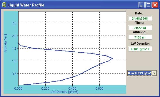
7 Liquid water profiling of clouds: RPG-MWR-PRO-TN Page 7 / 12

8 Humidity Profiling Integrated Water Vapour measurements remain accurate even with LWP of 1000 g/m2. RPG-MWR-PRO-TN Page 8 / 12

9 RPG Radiometer Combination The RPG-HATPRO can be easily combined and synchronized with other RPG radiometers to a virtually single instrument. Master/Slave Combination Matrix: RPG-HATPRO RPG-HUMPRO RPG-HATPRO RPG-HUMPRO RPG-TEMPRO RPG-LHATPRO RPG-LWP RPG-LWP-U90 RPG RPG-DP RPG RPG-TEMPRO-90 RPG-TEMPRO-150 RPG Possible Master/Slave combinations for current RPG models. Green: Ideal combination (no channel overlaps). Red: Channel overlaps RPG-TEMPRO RPG-LHATPRO RPG-LWP RPG-LWP-U90 RPG RPG-DP RPG RPG-TEMPRO-90 RPG-TEMPRO-150 RPG RPG-MWR-PRO-TN Page 9 / 12
10 Profiling Radiometer Models RPG-HUMPRO Humidity profiling radiometer 7 channels: GHz to 31.4 GHz over-sampling for redundancy RPG-TEMPRO Temperature profiling radiometer 7 channels 51 GHz to 58 GHz over-sampling for redundancy customized direct detection channels for precise BL-temperature profiles in elevation scanning mode RPG-HATPRO Humidity and Temperature Profiler (standard profiling radiometer) 7 channels: GHz to 31.4 GHz 7 channels 51 GHz to 58 GHz over-sampling for redundancy customized direct detection channels for precise BL-temperature profiles in elevation scanning mode RPG-LHATPRO Low-humidity and temperature profiler Designed for arctic conditions and/or high altitudes Water vapour sounding at 183 GHz 6 DSB channels with individual bandwidth Options (all Models) Azimuth positioner Fully supported by operating software 0 to 360 rotation IR-radiometer suite Single-Channel: Cloud base information Dual-Channel: Sensitive to small LWP / effective radius of cloud particles Steerable version available (fully synchronous steering with microwave obs) Warranty extensions May be ordered at initial deployment Continuation on a year-by-year basis RPG-MWR-PRO-TN Page 10 / 12
11 Detailed Instrument Specifications Parameter Humidity profile performance (zenith and along track) Temperature profile performance (zenith and along track) Liquid water profile performance (only with IR radiometer option) IR radiometer option LWP IWV Full sky IWV and LWP maps (only with azimuth positioner option) Satellite tracking mode (only with azimuth positioner option) Channel centre frequencies Channel bandwidth Specification Vertical resolution: 200 m (range m) 400 m (range m), 800 m (range m) Accuracy: 0.4 g/m 3 RMS (absolute hum.) 5% RMS (rel. humidity) Vertical resolution: BL-Mode: 50 m (range m) Z-Mode: 200 m (range m) 400 m (range m) Accuracy: 0.25 K RMS (range m) 0.50 K RMS (range m) 0.75 K RMS (range m) 1.00 K RMS (range m) Vertical resolution: 250 m (range m) 300 m (range m), 500 m (range m) Accuracy: cloud base height: 50 m (range m) 100 m (range m) 200 m (range m) 400 m (range m) 600 m (range m) density: 0.03 g/m 3 RMS Threshold: 50 g/m 2 LWP Only single layer clouds are modelled µm band, accuracy 1 K, noise: 0.2 K RMS Accuracy: ± 20 g/m 2 Noise: 2 g/m 2 RMS Accuracy: ± 0.2 kg/m 2 RMS Noise: 0.05 kg/m 2 RMS 350 points in 6 minutes rapid scanning Determines wet/dry delay,atmospheric attenuation and humidity profiles along line of sight for all visible GPS / Galileo satellites in a single scan (2 minutes) scanning with RINEX navigation file or direct GPS vector reading from GPS clock K-Band: GHz, GHz, GHz, GHz, GHz, GHz, 31.4 GHz V-Band: GHz, GHz, GHz, GHz, GHz, 57.3 GHz, 58.0 GHz GHz, GHz, GHz, 230 all other frequencies RPG-MWR-PRO-TN Page 11 / 12
12 Parameter System noise temperatures Radiometric resolution Absolute brightness temperature accuracy Radiometric range Absolute calibration Internal calibration Receiver and antenna thermal stabilization Gain nonlinearity error correction Brightness calculation Integration time Sampling rate for profiles Rain / fog mitigation system Environmental Sensors Data interface Data rate Instrument control (external PC) Instrument control (internal) Housekeeping Retrieval algorithms Optical resolution Sidelobe level Pointing speed (elevation) Pointing speed (azimuth), optional Specification <400 K for GHz profiler <500 K for GHz profiler K-Band: 0.10 K RMS, V-Band: 0.15 K RMS (at 1 sec int. time) 0.5 K K with internal ambient & external cold load gain: with internal noise standard gain + system noise: ambient temp. target + noise standard abs. cal. of humidity profiler: sky tipping calibration Stability better than 0.03 K over full operating temp. range Automatic, four point method based on exact Planck radiation law 0.4 seconds for each channel, user selectable 1 sec, user selectable Highly efficient blower system (130 Watts), hydrophobic coated microwave transparent window, 1.8 kw heater module preventing formation of dew under fog conditions On a 1-meter mast attached to the radiometer: - Temperature, pressure, relative humidity - Wind speed, wind direction (G3-instruments) Ethernet, 115 kbaud 10 kbyte/sec. Windows System with Ethernet interface Embedded PC, controls all internal calibrations, data acquisition, data file backup on 1 GB flash memory, control of azimuth positioner, communication with host, can run measurements independently from host PC all system parameters, calibration history documentation neural network, linear /nonlinear regression algorithms HPBW: 3.5 for water vapour, 1.8 for temperature profiler <-30dBc 45 /sec 40 /sec Operating temperature range -40 C to 45 C Power consumption Lightning protection Input voltage Weight <120 Watts average, 350 Watts peak for warming-up (without dew blower heater), blower: 130 Watts max. Power line: circuit breakers Data line: Fibre optics data cable (max. length: 1400 m) V AC, 50 to 60 Hz 60 kg (without dew blower) Dimensions cm 3 RPG-MWR-PRO-TN Page 12 / 12
RPG-HATPRO-G5 series High-precision microwave radiometers for continuous atmospheric profi ling
 High-precision microwave radiometers for continuous atmospheric profi ling Applications Tropospheric Profiling of temperature, humidity, and liquid water Water Vapour Monitoring e.g. at astronomical sites
Dual Polarized Radiometers DPR Series RPG DPR XXX. Applications. Features
 Dual Polarized Radiometers Applications Soil moisture measurements Rain observations Discrimination of Cloud Liquid (LWC) and Rain Liquid (LWR) Accurate LWP measurements during rain events Cloud physics
Technical Instrument Manual
 Technical Instrument Manual Description of Instrument Technology Applicable for: HATPRO, LHATPRO, TEMPRO, HUMPRO, LHUMPRO, LWP, LWP-U90, LWP-U72-82, LWP-90-150, Tau-225, Tau-225-350 Document Change Log
Technical Instrument Manual
 Pages: 45 Technical Instrument Manual Description of Instrument Technology Applicable for HATPRO, LHATPRO, TEMPRO, HUMPRO, LHUMPRO, LWP, LWP-U90, LWP-U72-82, LWP-90-150, Tau-225, Tau-225-350 Technical
RPG-FMCW-94-SP Cloud Radar
 Latest Results from the RPG-FMCW-94-SP Cloud Radar (or, to stay in line with WG-3: a few slides on a 89 GHz radiometer with some active 94 GHz extensions to give the radiometer-derived LWP a bit more vertical
HATPRO A Meteorological Observing System
 HATPRO A Meteorological Observing System Thomas Rose Harald Czekala RPG Radiometer Physics GmbH Meckenheim, Germany What is HATPRO? Direct detection passive microwave Humidity And Temperature PROfiler
Microwave-Radiometer
 Microwave-Radiometer Figure 1: History of cosmic background radiation measurements. Left: microwave instruments, right: background radiation as seen by the corresponding instrument. Picture: NASA/WMAP
The WVR at Effelsberg. Thomas Krichbaum
 The WVR at Effelsberg Alan Roy Ute Teuber Helge Rottmann Thomas Krichbaum Reinhard Keller Dave Graham Walter Alef The Scanning 18-26 GHz WVR for Effelsberg ν = 18.5 GHz to 26.0 GHz Δν = 900 MHz Channels
Mobile System for Remote Sensing of Wind, Humidity, Temperature and Precipitation Microstructure Profiles during Special Events and Sport Competitions
 Mobile System for Remote Sensing of Wind, Humidity, Temperature and Precipitation Microstructure Profiles during Special Events and Sport Competitions Introduction By Alexander Gusev, Viktor Ignatov, Arkadiy
Passive Microwave Sensors LIDAR Remote Sensing Laser Altimetry. 28 April 2003
 Passive Microwave Sensors LIDAR Remote Sensing Laser Altimetry 28 April 2003 Outline Passive Microwave Radiometry Rayleigh-Jeans approximation Brightness temperature Emissivity and dielectric constant
Assessment of instrument STability and Retrieval Algorithms for SMOS data (ASTRA)
") Assessment of instrument STability and Retrieval Algorithms for SMOS data (ASTRA) S.Paloscia IFAC-CNR MRSG - Microwave Remote Sensing Group Florence (Italy) Microwave Remote Sensing Group I - DOMEX-2 :
Assessment of instrument STability and Retrieval Algorithms for SMOS data (ASTRA) S.Paloscia IFAC-CNR MRSG - Microwave Remote Sensing Group Florence (Italy) Microwave Remote Sensing Group I - DOMEX-2 :
Earth Exploration-Satellite Service (EESS) - Passive Spaceborne Remote Sensing
 - Passive Spaceborne Remote Sensing") Earth Exploration-Satellite Service (EESS) - Passive Spaceborne Remote Sensing John Zuzek Vice-Chairman ITU-R Study Group 7 ITU/WMO Seminar on Spectrum & Meteorology Geneva, Switzerland 16-17 September
Earth Exploration-Satellite Service (EESS) - Passive Spaceborne Remote Sensing John Zuzek Vice-Chairman ITU-R Study Group 7 ITU/WMO Seminar on Spectrum & Meteorology Geneva, Switzerland 16-17 September
Profiling Radiometer for Atmospheric and Cloud Observations PRACO
 Profiling Radiometer for Atmospheric and Cloud Observations PRACO Boulder Environmental Sciences and Technology BEST Small startup company, established in 2006 Focused on radiometry ground based and airborne
RAPTOR TM Radar Wind Profiler Models
 Radiometrics, Corp. 4909 Nautilus Court North, Suite 110 Boulder, CO 80301 USA T (303) 449-9192 www.radiometrics.com RAPTOR TM Radar Wind Profiler Models Radiometrics, Corp. designs and manufactures a
Prototype Software-based Receiver for Remote Sensing using Reflected GPS Signals. Dinesh Manandhar The University of Tokyo
 Prototype Software-based Receiver for Remote Sensing using Reflected GPS Signals Dinesh Manandhar The University of Tokyo dinesh@qzss.org 1 Contents Background Remote Sensing Capability System Architecture
Emerging Technology for Satellite Remote Sensing of Boundary Layer Clouds and their Environment
 Emerging Technology for Satellite Remote Sensing of Boundary Layer Clouds and their Environment Matt Lebsock (NASA-JPL) Contributors: Chi Ao (NASA-JPL) Tom Pagano (NASA-JPL) Amin Nehir (NASA-Langley) Where
Weather Radar Systems. General Description
 General Description Our weather radars are designed for precipitation monitoring at both regional and urban scales. They can be advantageously used as gap filler of existing radar networks particularly
Propagation for Space Applications
 Propagation for Space Applications by Bertram Arbesser-Rastburg Chairman ITU-R SG3 Invited talk at LAPC 2014, Loughborough, UK bertram@arbesser.org Abstract:The presentation covers the key propagation
Airborne Water Vapor Science, Radiometer Requirements, and Capabilities
 Airborne Water Vapor Science, Radiometer Requirements, and Capabilities Professor Albin J. Gasiewski University of Colorado NOAA-CU Center for Environmental Technology (CET) al.gasiewski@colorado.edu 303-492-9688
Australian Wind Profiler Network and Data Use in both Operational and Research Environments
 Australian Wind Profiler Network and Data Use in both Operational and Research Environments Bronwyn Dolman 1,2 and Iain Reid 1,2 1 ATRAD Pty Ltd 20 Phillips St Thebarton South Australia www.atrad.com.au
Microwave Sounding. Ben Kravitz October 29, 2009
 Microwave Sounding Ben Kravitz October 29, 2009 What is Microwave Sounding? Passive sensor in the microwave to measure temperature and water vapor Technique was pioneered by Ed Westwater (c. 1978) Microwave
A network suitable microwave radiometer for operational monitoring of the cloudy atmosphere
 Atmospheric Research 75 (2005) 183 200 www.elsevier.com/locate/atmos A network suitable microwave radiometer for operational monitoring of the cloudy atmosphere Thomas Rose a,1, Susanne Crewell b, *, Ulrich
ELDES / METEK Weather Radar Systems. General Description
 General Description Our weather radars are designed for precipitation monitoring at both regional and urban scales. They can be advantageously used as gap fillers of existing radar networks particularly
Low-cost water vapour radiometry
 Low-cost water vapour radiometry Prospects and progress Tinus Stander, Pr.Eng, PhD, SMIEEE Hilo, 13 June 2017 Agenda Introduction to CEFIM mm-wave group Project Context An engineer s view of WVR Current
AVHRR/3 Operational Calibration
 AVHRR/3 Operational Calibration Jörg Ackermann, Remote Sensing and Products Division 1 Workshop`Radiometric Calibration for European Missions, 30/31 Aug. 2017`,Frascati (EUM/RSP/VWG/17/936014) AVHRR/3
RPG-8CH-DP 4 Frequency, Dual Polarized Radiometer (6.925 / / / GHz h/v)
") RPG-8CH-DP 4 Frequency, Dual Polarized Radiometer (6.925 / 10.65 / 18.70 / 36.50 GHz h/v) Version 5.5 (28. Oct. 2006) Operating Manual by Th. Rose, H. Czekala Radiometer Physics GmbH, (www.radiometer-physics.com)
RPG-8CH-DP 4 Frequency, Dual Polarized Radiometer (6.925 / 10.65 / 18.70 / 36.50 GHz h/v) Version 5.5 (28. Oct. 2006) Operating Manual by Th. Rose, H. Czekala Radiometer Physics GmbH, (www.radiometer-physics.com)
Lecture Notes Prepared by Prof. J. Francis Spring Remote Sensing Instruments
 Lecture Notes Prepared by Prof. J. Francis Spring 2005 Remote Sensing Instruments Material from Remote Sensing Instrumentation in Weather Satellites: Systems, Data, and Environmental Applications by Rao,
Forest Fire Detection by Low-Cost 13GHz Radiometer
 Forest Fire Detection by Low-Cost 13GHz Radiometer F. Alimenti, S. Bonafoni, G. Tasselli, S. Leone, L. Roselli, K. Solbach, P. Basili 1 Summary Introduction Principle of operation Sensor architecture Radiometer
The Sounding Instruments on Second Generation of Chinese Meteorological Satellite FY-3
 The Sounding Instruments on Second Generation of Chinese Meteorological Satellite FY-3 DONG Chaohua ZHANG Wenjian National Satellite Meteorological Center China Meteorological Administration Beijing 100081,
Microwave Remote Sensing (1)
") Microwave Remote Sensing (1) Microwave sensing encompasses both active and passive forms of remote sensing. The microwave portion of the spectrum covers the range from approximately 1cm to 1m in wavelength.
Microwave Remote Sensing (1) Microwave sensing encompasses both active and passive forms of remote sensing. The microwave portion of the spectrum covers the range from approximately 1cm to 1m in wavelength.
Altimeter Range Corrections
 Altimeter Range Corrections Schematic Summary Corrections Altimeters Range Corrections Altimeter range corrections can be grouped as follows: Atmospheric Refraction Corrections Sea-State Bias Corrections
Characterizing Atmospheric Turbulence and Instrumental Noise Using Two Simultaneously Operating Microwave Radiometers
 Characterizing Atmospheric Turbulence and Instrumental Noise Using Two Simultaneously Operating Microwave Radiometers Tobias Nilsson, Gunnar Elgered, and Lubomir Gradinarsky Onsala Space Observatory Chalmers
COMPARISON OF FM-CW AND PULSED CLOUD RADARS AND LIDAR PERFORMANCE
 COMPARISON OF FM-CW AND PULSED CLOUD RADARS AND LIDAR PERFORMANCE Anthony Illingworth and Ewan O Connor University of Reading COST ES-0702 and NetFAM Joint Workshop Oslo, Norway, 18-20 March 2009 1 1.
SODAR- sonic detecting and ranging
 Active Remote Sensing of the PBL Immersed vs. remote sensors Active vs. passive sensors RADAR- radio detection and ranging WSR-88D TDWR wind profiler SODAR- sonic detecting and ranging minisodar RASS RADAR
Product data sheet Palas Fidas 200 E
 Product data sheet Palas Fidas 200 E Applications Regulatory environmental monitoring in measuring networks Ambient air measurement campaigns Long-term studies Emission source classification Distribution
Southwest Microwave, Inc S. McKemy Street Tempe, Arizona USA (480) Fax (480) Product Specifications
 Fax (480) Product Specifications") Southwest Microwave, Inc. 9055 S. McKemy Street Tempe, Arizona 85284 USA (480) 783-0201 - Fax (480) 783-0401 Product Specifications MODEL 380 K-BAND OUTDOOR MICROWAVE TRANSCEIVER SPECIFICATION 1.0 DESCRIPTION
Southwest Microwave, Inc. 9055 S. McKemy Street Tempe, Arizona 85284 USA (480) 783-0201 - Fax (480) 783-0401 Product Specifications MODEL 380 K-BAND OUTDOOR MICROWAVE TRANSCEIVER SPECIFICATION 1.0 DESCRIPTION
Estimation of Rain attenuation and Ionospheric delay at a Low-Latitude Indian Station
 Estimation of Rain attenuation and Ionospheric delay at a Low-Latitude Indian Station Amita Gaur 1, Som Kumar Sharma 2 1 Vellore Institute of Technology, Vellore, India 2 Physical Research Laboratory,
Design and Development of a Ground-based Microwave Radiometer System
 PIERS ONLINE, VOL. 6, NO. 1, 2010 66 Design and Development of a Ground-based Microwave Radiometer System Yu Zhang 1, 2, Jieying He 1, 2, and Shengwei Zhang 1 1 Center for Space Science and Applied Research,
Microwave Sensors Subgroup (MSSG) Report
 Report") Microwave Sensors Subgroup (MSSG) Report Feb 17-20, 2014, ESA ESRIN, Frascati, Italy DONG, Xiaolong, MSSG Chair National Space Science Center Chinese Academy of Sciences (MiRS,NSSC,CAS) Email: dongxiaolong@mirslab.cn
Microwave Sensors Subgroup (MSSG) Report Feb 17-20, 2014, ESA ESRIN, Frascati, Italy DONG, Xiaolong, MSSG Chair National Space Science Center Chinese Academy of Sciences (MiRS,NSSC,CAS) Email: dongxiaolong@mirslab.cn
SYSTEM ARCHITECTURE OF RADAR NETWORK FOR MONITORING OF HAZARDOUD WEATHER
 SYSTEM ARCHITECTURE OF RADAR NETWORK FOR MONITORING OF HAZARDOUD WEATHER 2008. 11. 21 HOON LEE Gwangju Institute of Science and Technology &. CONTENTS 1. Backgrounds 2. Pulse Compression 3. Radar Network
Fundamentals of Remote Sensing
 Climate Variability, Hydrology, and Flooding Fundamentals of Remote Sensing May 19-22, 2015 GEO-Latin American & Caribbean Water Cycle Capacity Building Workshop Cartagena, Colombia 1 Objective To provide
DATAMAR 2000 MICROWAVE (26 GHz) RADAR TIDE GAUGE
 RADAR TIDE GAUGE") DATAMAR 2000 MICROWAVE (26 GHz) RADAR TIDE GAUGE BATTERY POWERED COMPACT AND STAND ALONE TIDE GAUGE WITH MICROWAVE RADAR SENSOR (26 GHz) PROVIDING EXTREMELY HIGH PRECISION AND STABILITY Level measurements
DATAMAR 2000 MICROWAVE (26 GHz) RADAR TIDE GAUGE BATTERY POWERED COMPACT AND STAND ALONE TIDE GAUGE WITH MICROWAVE RADAR SENSOR (26 GHz) PROVIDING EXTREMELY HIGH PRECISION AND STABILITY Level measurements
C.1 Calibrating Radiometrics MP-xx00A Radiometers with Liquid Nitrogen (LN2) Safety Considerations
 Safety Considerations") Appendix C: Radiometer Calibrations C.1 Calibrating Radiometrics MP-xx00A Radiometers with Liquid Nitrogen (LN2) Safety Considerations Liquid Nitrogen (LN2) is extremely cold. It can cause severe burns
Appendix C: Radiometer Calibrations C.1 Calibrating Radiometrics MP-xx00A Radiometers with Liquid Nitrogen (LN2) Safety Considerations Liquid Nitrogen (LN2) is extremely cold. It can cause severe burns
DYNAMO Aircraft Operations
 DYNAMO Aircraft Operations Aircraft: NOAA WP-3D, "Kermit" N42RF Flight hours: 105 science mission hours + 70 ferry hours Aircraft operation base: Diego Garcia (7.3 S, 72.5 E) Operation period: 45 days
RPG-XCH-DP X Frequency, Dual Polarized Radiometer (6.925 / / (21.00) / GHz h/v)
 / GHz h/v)") RPG-XCH-DP X Frequency, Dual Polarized Radiometer (6.925 / 10.65 / 18.70 (21.00) / 36.50 GHz h/v) Version 6.8 (18. 2. 2009) Operating Manual by Th. Rose, H. Czekala Radiometer Physics GmbH, (www.radiometer-physics.com)
RPG-XCH-DP X Frequency, Dual Polarized Radiometer (6.925 / 10.65 / 18.70 (21.00) / 36.50 GHz h/v) Version 6.8 (18. 2. 2009) Operating Manual by Th. Rose, H. Czekala Radiometer Physics GmbH, (www.radiometer-physics.com)
Windsond Product Catalogue
 Windsond Product Catalogue Windsond is a weather balloon system for an immediate view of local conditions at different altitudes. The focus on portability and low operating costs makes it perfect for frequent
Space Frequency Coordination Group
 Space Frequency Coordination Group Report SFCG 38-1 POTENTIAL RFI TO EESS (ACTIVE) CLOUD PROFILE RADARS IN 94.0-94.1 GHZ FREQUENCY BAND FROM OTHER SERVICES Abstract This new SFCG report analyzes potential
GPS10RBN-26: 10 MHz, GPS Disciplined, Ultra Low Noise Rubidium Frequency Standard
 GPS10RBN-26: 10 MHz, GPS Disciplined, Ultra Low Noise Rubidium Standard Key Features Completely self-contained unit. No extra P.C needed. Full information available via LCD. Rubidium Oscillator locked
Govt. Engineering College Jhalawar Model Question Paper Subject- Remote Sensing & GIS
 Govt. Engineering College Jhalawar Model Question Paper Subject- Remote Sensing & GIS Time: Max. Marks: Q1. What is remote Sensing? Explain the basic components of a Remote Sensing system. Q2. What is
JDA Systems. VT-063 Series Autotracking Antenna
 JDA Systems VT-063 Series Autotracking Antenna The VT-063 twin-axis 6.3 meter diameter Autotracking antenna system from VuTrack is the culmination of a multi year company sponsored research and development
Sea surface temperature observation through clouds by the Advanced Microwave Scanning Radiometer 2
 Sea surface temperature observation through clouds by the Advanced Microwave Scanning Radiometer 2 Akira Shibata Remote Sensing Technology Center of Japan (RESTEC) Tsukuba-Mitsui blds. 18F, 1-6-1 Takezono,
High Resolution W-Band Radar Detection and Characterization of Aircraft Wake Vortices in Precipitation. Thomas A. Seliga and James B.
 High Resolution W-Band Radar Detection and Characterization of Aircraft Wake Vortices in Precipitation Thomas A. Seliga and James B. Mead 4L 4R 4L/22R 4R/22L W-Band Radar Site The W-Band Radar System
EISCAT Scientific Association Technical Specification and Requirements for Antenna Unit V 2.0
 EISCAT Scientific Association Technical Specification and s for Antenna Unit V 2.0 1. Technical Specification for Antenna Unit The EISCAT Scientific Association, also called "EISCAT" throughout this document,
Frequency bands and bandwidths used for satellite passive remote sensing
 Recommendation ITU-R RS.515-5 (08/2012) Frequency bands and bandwidths used for satellite passive remote sensing RS Series Remote sensing systems ii Rec. ITU-R RS.515-5 Foreword The role of the Radiocommunication
Radar Reprinted from "Waves in Motion", McGourty and Rideout, RET 2005
 Radar Reprinted from "Waves in Motion", McGourty and Rideout, RET 2005 What is Radar? RADAR (Radio Detection And Ranging) is a way to detect and study far off targets by transmitting a radio pulse in the
Detection & Localization of L-Band Satellites using an Antenna Array
 Detection & Localization of L-Band Satellites using an Antenna Array S.W. Ellingson Virginia Tech ellingson@vt.edu G.A. Hampson Ohio State / ESL June 2004 Introduction Traditional radio astronomy uses
Typical technical and operational characteristics of Earth exploration-satellite service (passive) systems using allocations between 1.
 systems using allocations between 1.") Recommendation ITU-R RS.1861 (01/2010) Typical technical and operational characteristics of Earth exploration-satellite service (passive) systems using allocations between 1.4 and 275 GHz RS Series Remote
Recommendation ITU-R RS.1861 (01/2010) Typical technical and operational characteristics of Earth exploration-satellite service (passive) systems using allocations between 1.4 and 275 GHz RS Series Remote
DEVELOPMENT AND IMPLEMENTATION OF AN ATTENUATION CORRECTION ALGORITHM FOR CASA OFF THE GRID X-BAND RADAR
 DEVELOPMENT AND IMPLEMENTATION OF AN ATTENUATION CORRECTION ALGORITHM FOR CASA OFF THE GRID X-BAND RADAR S98 NETWORK Keyla M. Mora 1, Leyda León 1, Sandra Cruz-Pol 1 University of Puerto Rico, Mayaguez
Chapter 41 Deep Space Station 13: Venus
 Chapter 41 Deep Space Station 13: Venus The Venus site began operation in Goldstone, California, in 1962 as the Deep Space Network (DSN) research and development (R&D) station and is named for its first
Heterodyne Sweeping Radiometer
 46 Robezu str. LV-1004 Riga, Latvia Fax: +371-7-065102 Mm-wave Division in St. Petersburg, Russia Fax: +7-812- 326-10-60 Tel: +7-812-326-59-24 E-mail: ivanovph@nnz.ru Heterodyne Sweeping Radiometer Operation
2. Measurement Range / Further specifications of the LOG_aLevel system
 1. Introduction General Acoustics, e.k., founded in 1996, with its origins as an acoustics and sensors research and services partnership, is now a high-end technology producer of sophisticated water level
Microwave Radiometry Laboratory Experiment
 Microwave Radiometry Laboratory Experiment JEFFREY D. DUDA Iowa State University Department of Geologic and Atmospheric Sciences ABSTRACT A laboratory experiment involving the use of a microwave radiometer
Technical Report Analysis of SSMIS data. Eva Howe. Copenhagen page 1 of 16
 Analysis of SSMIS data Eva Howe Copenhagen 9 www.dmi.dk/dmi/tr08-07 page 1 of 16 Colophon Serial title: Technical Report 08-07 Title: Analysis of SSMIS data Subtitle: Author(s): Eva Howe Other contributors:
Narda DF Antennas - Datasheet. Datasheet
 Narda DF Antennas - Datasheet Datasheet To cover a wide frequency range with high sensitivity, Narda offers several directional antennas. Each antenna is optimized for their particular frequency range
Guide to the application of the propagation methods of Radiocommunication Study Group 3
 Recommendation ITU-R P.1144-6 (02/2012) Guide to the application of the propagation methods of Radiocommunication Study Group 3 P Series Radiowave propagation ii Rec. ITU-R P.1144-6 Foreword The role of
ATS 351 Lecture 9 Radar
 ATS 351 Lecture 9 Radar Radio Waves Electromagnetic Waves Consist of an electric field and a magnetic field Polarization: describes the orientation of the electric field. 1 Remote Sensing Passive vs Active
Table 9-1 Operating characteristics of upper-air meteorological monitoring systems. BOUNDARY LAYER VARIABLES RADIOSONDE DOPPLER SODAR
 Table 9-1 VARIABLES p, T, RH Vector winds (WS, WD) Vector winds (WS, WD) Virtual temperature (T v ) Measured Vector winds (WS, WD) u,v,w wind components u,v,w wind components w wind component Altitude
Vaisala DigiCORA Sounding System
 Vaisala DigiCORA Sounding System Leading the world in BUFR messaging All you need to measure the upper air atmospheric profile The Vaisala DigiCORA Sounding System simplifies your daily synoptic observations
Chapter 8. Remote sensing
 1. Remote sensing 8.1 Introduction 8.2 Remote sensing 8.3 Resolution 8.4 Landsat 8.5 Geostationary satellites GOES 8.1 Introduction What is remote sensing? One can describe remote sensing in different
Kidder, Jones, Purdom, and Greenwald BACIMO 98 First Local Area Products from the NOAA-15 Advanced Microwave Sounding Unit (AMSU) page 1 of 5
 page 1 of 5") First Local Area Products from the NOAA-15 Advanced Microwave Sounding Unit (AMSU) Stanley Q. Kidder, Andrew S. Jones*, James F. W. Purdom, and Thomas J. Greenwald Cooperative Institute for Research in
First Local Area Products from the NOAA-15 Advanced Microwave Sounding Unit (AMSU) Stanley Q. Kidder, Andrew S. Jones*, James F. W. Purdom, and Thomas J. Greenwald Cooperative Institute for Research in
Holography Transmitter Design Bill Shillue 2000-Oct-03
 Holography Transmitter Design Bill Shillue 2000-Oct-03 Planned Photonic Reference Distribution for Test Interferometer The transmitter for the holography receiver is made up mostly of parts that are already
Final Examination. 22 April 2013, 9:30 12:00. Examiner: Prof. Sean V. Hum. All non-programmable electronic calculators are allowed.
 UNIVERSITY OF TORONTO FACULTY OF APPLIED SCIENCE AND ENGINEERING The Edward S. Rogers Sr. Department of Electrical and Computer Engineering ECE 422H1S RADIO AND MICROWAVE WIRELESS SYSTEMS Final Examination
Aquarius/SAC-D Mission Mission Simulators - Gary Lagerloef 6 th Science Meeting; Seattle, WA, USA July 2010
 Aquarius/SAC-D Mission Mission Simulators - Gary Lagerloef 6 th Science Meeting; Seattle, WA, USA Mission Design and Sampling Strategy Sun-synchronous exact repeat orbit 6pm ascending node Altitude 657
Status of Aeolus ESA s Wind Lidar Mission
 Status of Aeolus ESA s Wind Lidar Mission Roland Meynart, Anders Elfving, Denny Wernham and Anne Grete Straume European Space Agency/ESTEC Coherent Laser Radar Conference, Boulder 26 June-01 July 2016
Signal Flow & Radiometer Equation. Aletha de Witt AVN-Newton Fund/DARA 2018 Observational & Technical Training HartRAO
 Signal Flow & Radiometer Equation Aletha de Witt AVN-Newton Fund/DARA 2018 Observational & Technical Training HartRAO Understanding Radio Waves The meaning of radio waves How radio waves are created -
Monitoring the Ionosphere and Neutral Atmosphere with GPS
 Monitoring the Ionosphere and Neutral Atmosphere with GPS Richard B. Langley Geodetic Research Laboratory Department of Geodesy and Geomatics Engineering University of New Brunswick Fredericton, N.B. Division
Current and Future Meteorological Satellite Program of China
 Current and Future Meteorological Satellite Program of China ZHANG Wenjian, DONG Chaohua XU Jianmin, YANG Jun China Meteorological Administration May 30, 2005 Beijing, CHINA Outline of the Presentation
Microwave Sensors Subgroup (MSSG) Report
 Report") Microwave Sensors Subgroup (MSSG) Report CEOS WGCV-35 May 13-17, 2013, Shanghai, China DONG, Xiaolong, MSSG Chair CAS Key Laboratory of Microwave Remote Sensing National Space Science Center Chinese Academy
Microwave Sensors Subgroup (MSSG) Report CEOS WGCV-35 May 13-17, 2013, Shanghai, China DONG, Xiaolong, MSSG Chair CAS Key Laboratory of Microwave Remote Sensing National Space Science Center Chinese Academy
Outlines. Attenuation due to Atmospheric Gases Rain attenuation Depolarization Scintillations Effect. Introduction
 PROPAGATION EFFECTS Outlines 2 Introduction Attenuation due to Atmospheric Gases Rain attenuation Depolarization Scintillations Effect 27-Nov-16 Networks and Communication Department Loss statistics encountered
Windsond Product Catalogue
 Windsond Product Catalogue Windsond is a weather balloon system for an immediate view of local conditions at different altitudes. The focus on portability and low operating costs makes it perfect for frequent
Leica GRX1200 Series High Performance GNSS Reference Receivers
 Leica GRX1200 Series High Performance GNSS Reference Receivers Leica GRX1200 Series For permanent reference stations The Leica GRX1200 Series, part of Leica s new System 1200, is designed specifically
Towards the Verification of Dual-wavelength Radar Estimates of Liquid Water Content Using Microwave Radiometer Measurements
 Towards the Verification of Dual-wavelength Radar Estimates of Liquid Water Content Using Microwave Radiometer Measurements Scott Ellis 1, JothiramVivekanandan 1, Paquita Zuidema 2 1. NCAR Earth Observing
Remote sensing radio applications/ systems for environmental monitoring
 Remote sensing radio applications/ systems for environmental monitoring Alexandre VASSILIEV ITU Radiocommunication Bureau phone: +41 22 7305924 e-mail: alexandre.vassiliev@itu.int 1 Source: European Space
Kazuhiro TANAKA GCOM project team/jaxa April, 2016
 Kazuhiro TANAKA GCOM project team/jaxa April, 216 @ SPIE Asia-Pacific 216 at New Dehli, India 1 http://suzaku.eorc.jaxa.jp/gcom_c/index_j.html GCOM mission and satellites SGLI specification and IRS overview
The Cosmic Microwave Background Radiation B. Winstein, U of Chicago
 The Cosmic Microwave Background Radiation B. Winstein, U of Chicago Lecture #1 Lecture #2 What is it? How its anisotropies are generated? What Physics does it reveal? How it is measured. Lecture #3 Main
Data Sheet SC5317 & SC5318A. 6 GHz to 26.5 GHz RF Downconverter SignalCore, Inc. All Rights Reserved
 Data Sheet SC5317 & SC5318A 6 GHz to 26.5 GHz RF Downconverter www.signalcore.com 2018 SignalCore, Inc. All Rights Reserved Definition of Terms 1 Table of Contents 1. Definition of Terms... 2 2. Description...
CAL/VAL ACTIVITIES IN ROSHYDROMET. GSICS Executive Panel 14, Tokyo, 15 July. 2013
 CAL/VAL ACTIVITIES IN ROSHYDROMET GSICS Executive Panel 14, Tokyo, 15 July. 2013 Future CAL/VAL system deployment in Roshydromet Roshydromet has started the deployment of ground-based calibration/validation
2B.6 SALIENT FEATURES OF THE CSU-CHILL RADAR X-BAND CHANNEL UPGRADE
 2B.6 SALIENT FEATURES OF THE CSU-CHILL RADAR X-BAND CHANNEL UPGRADE Francesc Junyent* and V. Chandrasekar, P. Kennedy, S. Rutledge, V. Bringi, J. George, and D. Brunkow Colorado State University, Fort
A STUDY OF DOPPLER BEAM SWINGING USING AN IMAGING RADAR
 .9O A STUDY OF DOPPLER BEAM SWINGING USING AN IMAGING RADAR B. L. Cheong,, T.-Y. Yu, R. D. Palmer, G.-F. Yang, M. W. Hoffman, S. J. Frasier and F. J. López-Dekker School of Meteorology, University of Oklahoma,
Geo/SAT 2 INTRODUCTION TO REMOTE SENSING
 Geo/SAT 2 INTRODUCTION TO REMOTE SENSING Paul R. Baumann, Professor Emeritus State University of New York College at Oneonta Oneonta, New York 13820 USA COPYRIGHT 2008 Paul R. Baumann Introduction Remote
Global Environmental MEMS Sensors (GEMS): Revolutionary Observing Technology for the 21st Century
: Revolutionary Observing Technology for the 21st Century") Global Environmental MEMS Sensors (GEMS): Revolutionary Observing Technology for the 21st Century NIAC Phase I CP-01-02 John Manobianco, Randolph J. Evans, Jonathan L. Case, David A. Short ENSCO, Inc.
Global Environmental MEMS Sensors (GEMS): Revolutionary Observing Technology for the 21st Century NIAC Phase I CP-01-02 John Manobianco, Randolph J. Evans, Jonathan L. Case, David A. Short ENSCO, Inc.
S3 Product Notice Altimetry
 S3 Product Notice Altimetry Mission Sensor Product S3-A SRAL / MWR LAND L2 NRT, STC and NTC Product Notice ID Issue/Rev Date Version 1.0 Preparation S3A.PN-STM-L2L.04 13-Dec-2017 This Product Notice was
Final Examination Introduction to Remote Sensing. Time: 1.5 hrs Max. Marks: 50. Section-I (50 x 1 = 50 Marks)
") Final Examination Introduction to Remote Sensing Time: 1.5 hrs Max. Marks: 50 Note: Attempt all questions. Section-I (50 x 1 = 50 Marks) 1... is the technology of acquiring information about the Earth's
Final Examination Introduction to Remote Sensing Time: 1.5 hrs Max. Marks: 50 Note: Attempt all questions. Section-I (50 x 1 = 50 Marks) 1... is the technology of acquiring information about the Earth's
Sw earth Dw Direct wave GRw Ground reflected wave Sw Surface wave
 WAVE PROPAGATION By Marcel H. De Canck, ON5AU Electromagnetic radio waves can propagate in three different ways between the transmitter and the receiver. 1- Ground waves 2- Troposphere waves 3- Sky waves
Exercise 1-4. The Radar Equation EXERCISE OBJECTIVE DISCUSSION OUTLINE DISCUSSION OF FUNDAMENTALS
 Exercise 1-4 The Radar Equation EXERCISE OBJECTIVE When you have completed this exercise, you will be familiar with the different parameters in the radar equation, and with the interaction between these
UNIT Derive the fundamental equation for free space propagation?
 UNIT 8 1. Derive the fundamental equation for free space propagation? Fundamental Equation for Free Space Propagation Consider the transmitter power (P t ) radiated uniformly in all the directions (isotropic),
RECOMMENDATION ITU-R S.733-1* (Question ITU-R 42/4 (1990))**
)**") Rec. ITU-R S.733-1 1 RECOMMENDATION ITU-R S.733-1* DETERMINATION OF THE G/T RATIO FOR EARTH STATIONS OPERATING IN THE FIXED-SATELLITE SERVICE (Question ITU-R 42/4 (1990))** Rec. ITU-R S.733-1 (1992-1993)
Rec. ITU-R S.733-1 1 RECOMMENDATION ITU-R S.733-1* DETERMINATION OF THE G/T RATIO FOR EARTH STATIONS OPERATING IN THE FIXED-SATELLITE SERVICE (Question ITU-R 42/4 (1990))** Rec. ITU-R S.733-1 (1992-1993)
SATELLITE OCEANOGRAPHY
 SATELLITE OCEANOGRAPHY An Introduction for Oceanographers and Remote-sensing Scientists I. S. Robinson Lecturer in Physical Oceanography Department of Oceanography University of Southampton JOHN WILEY
Modelling GPS Observables for Time Transfer
 Modelling GPS Observables for Time Transfer Marek Ziebart Department of Geomatic Engineering University College London Presentation structure Overview of GPS Time frames in GPS Introduction to GPS observables
Guide to observation planning with GREAT
 Guide to observation planning with GREAT G. Sandell GREAT is a heterodyne receiver designed to observe spectral lines in the THz region with high spectral resolution and sensitivity. Heterodyne receivers