Airborne Water Vapor Science, Radiometer Requirements, and Capabilities
|
|
|
- Derick Briggs
- 5 years ago
- Views:
Transcription
1 Airborne Water Vapor Science, Radiometer Requirements, and Capabilities Professor Albin J. Gasiewski University of Colorado NOAA-CU Center for Environmental Technology (CET) NCAR Boulder CO Airborne Radiometry Workshop September 23-24, 2014
2 Key Points Airborne radiometric profiling of water vapor requires: At least one (183 GHz) and up to four key direct-sensing H 2 O v bands, and At least one (50-57 or 118 GHz) and up to three key O 2 bands for temperature profiling At least one (90 GHz) and up to five window bands for cloud/precipitation sensing and correction Retrieval methods and achievable vertical resolutions in clear air are well established. Improvements are yet possible using hyperspectral channel sets and by improving stability and calibration precision. Systems for the above require moderately large apertures and correspondingly heavy aircraft or large bays. Such systems (e.g. PSR) are mature. Lighter aircraft or w/o large bays would benefit from compact integrated systems (e.g. PRACO). NCAR Boulder CO Airborne Radiometry Workshop September 23-24, 2014

3 Clear-Air Opacity Spectrum Key tropospheric water vapor (H 2 O v ) and temperature (O 2 ) bands Klein & Gasiewski, JGR-ATM, July 2000 NCAR Boulder CO Airborne Radiometry Workshop September 23-24, 2014

4 Vertical Responses - Clear Air - Clear-air incemental weighting functions O GHz GHz H 2 O GHz /340 Klein & Gasiewski, JGR-ATM, July 2000 NCAR Boulder CO Airborne Radiometry Workshop September 23-24, 2014

5 GHz Temperature Profiling MTS 7-channel airborne instrument ±0.5 GHz ±1.9 GHz * Gasiewski and Johnson, TGARS, 1993 Some improvement possible in: - Use of hyperspectral channel sets - Receiver stability/calibration
6 Nonlinear Iterative Humidity Profiling NOAA 183 GHz MSU Data Pressure (mb) A priori STD Linear D-matrix Nonlinear Iterative Some improvement possible in: - Use of larger channel sets (7x 183 GHz channels) - Receiver stability/calibration - Neural net algorithms Relative Humidity RMS Error (%) *Kuo and Staelin, TGARS,
7 Effects of Hydrometeors on Microwave Signatures Scattering and absorption by hydrometeors need to be considered for radiometric water vapor or temperature profile measurements: Liquid Ice NCAR Boulder CO Airborne Radiometry Workshop September 23-24, 2014

8 S a T B S T B A T B T B g T B T JCSDA Seminar November 14, 2012 College Park, MD

9 JCSDA Seminar November 14, 2012 College Park, MD

 ~ f 2.")
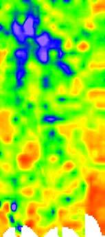
10 Frequency Selection Issues V. Leslie NAST-M Convective Cells Observed from 20 km altitude over ocean GHz ±2.05 GHz ±1.8 GHz ±3.25 GHz 45 km 45 km 45 km 45 km 45 km Aircraft data tells us: The 50-GHz band responds only to very strong convection in cell centers; partial beamfilling yields weak/no response. Combined frequencies yield particle sizes, convective strength; cell diameters ~ 1/f. Even 425 GHz sees through cirrus to convective outflow. Small-cell sensitivity is proportional to (cell diameter/ant diam.) ~ f 2. D cell ~ f Diameter ratio: ~ f 2 D beam f -1 National Space Science Center October 12, 2012 From Surussavadee and Staelin, April 2007 Beijing, China

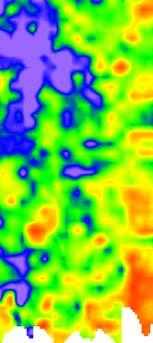
11 SMMW Precipitation Cell Spectra Maritime convection observed at 20 km altitude ~200 km Redundant information? Gasiewski, et al, Proc IGARSS, Pasadena, USA. National Space Science Center October 12, 2012 Beijing, China
 National Space Science Center October 12, 2012 Beijing,")
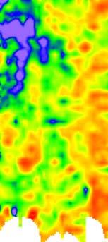
12 SMMW Degrees of Freedom - Maritime Convective Precipitation ±9 Nonlinear Karhunen-Loeve (KL) mode decomposition: MIR 150, 220, & 325±9 GHz channels k 1 k 2 k 3 ~200 km (Gasiewski 1996, unpublished) National Space Science Center October 12, 2012 Beijing, China

13 Submillimeter Wave Cloud Ice Sensing NASA GSFC SMMW Imaging Radiometer * Evans, et al.,
14 424+/-4 GHz Simulations 3 hour time steps T B S T B A T B T JCSDA Seminar November 14, 2012 College Park, MD

15 424+/-4 GHz Simulations - 15 min time steps T B S T B A T B T JCSDA Seminar November 14, 2012 College Park, MD


16 Polarimetric Scanning Radiometer (PSR) System PSR/A: 10.7, 18.7, 21.5, 37, 89 GHz Polarimetric PSR/CX: 6-7.3, GHz Polarimetric with Interference Mitigation PSR/S PSR/L: 1.4 GHz V IR 18/ JCSDA Seminar November 14, 2012 College Park, MD


 provide full AMSU-A/B and")


17 CU CET Passive Microwave Vertical Sounder 55 GHz 89 GHz 183 GHz CET spectrometer modules with internal fast-switched absolute calibration. Above spectrometers (plus two more under development) provide full AMSU-A/B and NPOESS CMIS and ATMS tropospheric sounding compatibility. Microwave sounders as installed in PSR/S airborne radiometer sensor head NCAR Boulder CO Airborne Radiometry Workshop September 23-24, 2014


18 Airborne Imaging Radiometry 10.7 GHz 37.0 GHz 89.0 GHz 18.7 GHz 21.5 GHz Video 10 m IR 6.7 GHz 10.7 GHz PSR installs on NASA DC-8, P-3B, WB-57F, ER-2, Altair, Navy P-3C, NRL P-3. NCAR Boulder CO Airborne Radiometry Workshop September 23-24, 2014


19 Topic Altair Integrated Package First UAV-based passive microwave vertical sounding sensor NCAR Boulder CO Airborne Radiometry Workshop September 23-24, 2014


20 Atmospheric River Sounding - Weak Atm River Penetrated on May 9, GHz A 89 GHz B 183 GHz 10 um IR D C A B C D 50 K NCAR Boulder CO Airborne Radiometry Workshop September 23-24, 2014
21 RHUBC 2007 Barrow, AK - PSR/S Ground Based - (Westwater, et al.) PWV (cm) MWR GSR RS92 Julian day Comparison of Precipitable Water Vapor Retrievals from the ARM MWR, the CET GSR, and Vaisala RS92 radiosondes launched during RHUBC on Julian Day 65, 2007.

 10.7 & 37 GHz 18.7 & 21.")
22 TRMM Calibration/Validation 10.7H GHz emission-based rain rate retrieval algorithm Data from CAMEX-3, DC-8 overflights of Hurricane Bonnie TMI RR (mm/hr 0-16) ρ~0.91 PSR RR (mm/hr 0-16) 10.7 & 37 GHz 18.7 & 21.6 GHz Video 89 GHz NCAR Boulder CO Airborne Radiometry Workshop September 23-24, 2014

 CAMEX3 -")

23 High-Resolution MCS and Hurricane Rainband Imaging PSR/A 10.7H GHz Rain Rate vs TRMM TMI (2A12) Front Look Back Look RR (mm/hr 0-16) CAMEX3 - Hurricane Bonnie near landfall, August 26, 1998 NCAR Boulder CO Airborne Radiometry Workshop September 23-24, 2014
.")

24 Hurricane Bonnie at Landfall Airborne Microwave Imagery PSR/A 10.7H GHz imagery from aircraft overpasses of hurricane Bonnie at GMT (August 26, 1998). High-resolution airborne imagery clearly reveals - over a limited region many submesoscale details of rainband precipitation structure absent in satellite imagery. NCAR Boulder CO Airborne Radiometry Workshop September 23-24, 2014


25 UIUC Seminar November 07, 2006


26 Regional SM Images - SMEX02 Central Iowa - Loam / Flat Topography June 25 June 27 June 29 July 1 July July 8 July 9 July 10 July 11 July

27 Sea Ice Mapping - Multi-Year Ice - Beaufort Sea, March 19, H Filamentary structure from pressure ridging observed at ~5 km scale ~100 km ~350 m UIUC resolution Seminar PSR/CX November 07, 2006
28 Ocean Surface Azimuthal Emission Harmonics W=10 m/s UIUC Seminar November 07, 2006


29 Microwave Wind Vector Imaging Labrador Sea Cold Cyclone - PSR/D - March 7, 1997 Full-scan passive microwave wind vector retrievals during two crossings of a cold cyclone centered in the Labrador Sea. Retrieved wind vectors are overlaid onto PSR and SSM/I 37H GHz imagery. Blue arrows are wind data from the NOAA/NCEP Eta analysis, dropsondes are orange arrows. Tight cyclonic rotation of the retrieved and model wind fields about the center of rotation is revealed.
30 Summary Airborne radiometric profiling of water vapor requires: At least one (183 GHz) and up to four key direct-sensing H 2 O v bands, and At least one (50-57 or 118 GHz) and up to three key O 2 bands for temperature profiling At least one (90 GHz) and up to five window bands for cloud/precipitation sensing and correction Retrieval methods and achievable vertical resolutions in clear air are well established. Improvements are yet possible using hyperspectral channel sets and by improving stability and calibration precision. Systems for the above require moderately large apertures and correspondingly heavy aircraft or large bays. Such systems (e.g. PSR) are mature. Lighter aircraft or w/o large bays would benefit from compact integrated systems (e.g. PRACO). NCAR Boulder CO Airborne Radiometry Workshop September 23-24, 2014
31 NCAR Boulder CO Airborne Radiometry Workshop September 23-24, 2014
The Geosynchronous Microwave (GEM) Sounder/Imager
 Sounder/Imager") The Geosynchronous Microwave (GEM) Sounder/Imager Albin J. Gasiewski NOAA Environmental Technology Laboratory Boulder, CO, USA David H. Staelin Massachusetts Institute of Technology Cambridge, MA, USA
The Geosynchronous Microwave (GEM) Sounder/Imager Albin J. Gasiewski NOAA Environmental Technology Laboratory Boulder, CO, USA David H. Staelin Massachusetts Institute of Technology Cambridge, MA, USA
Prospects for All-Weather Microwave Radiance Assimilation
 Prospects for All-Weather Microwave Radiance Assimilation A.J. Gasiewski 1, A. Voronovich 1, B.L. Weber 2, B. Stankov 1, M. Klein 3, R.J. Hill 1, and J.W. Bao 1 1) NOAA/Environmental Technology Laboratory,
Kidder, Jones, Purdom, and Greenwald BACIMO 98 First Local Area Products from the NOAA-15 Advanced Microwave Sounding Unit (AMSU) page 1 of 5
 page 1 of 5") First Local Area Products from the NOAA-15 Advanced Microwave Sounding Unit (AMSU) Stanley Q. Kidder, Andrew S. Jones*, James F. W. Purdom, and Thomas J. Greenwald Cooperative Institute for Research in
First Local Area Products from the NOAA-15 Advanced Microwave Sounding Unit (AMSU) Stanley Q. Kidder, Andrew S. Jones*, James F. W. Purdom, and Thomas J. Greenwald Cooperative Institute for Research in
Airborne Radio Frequency Interference Studies at C-band Using a Digital Receiver
 Airborne Radio Frequency Interference Studies at C-band Using a Digital Receiver IGARSS 2004: Frequency Allocations for Remote Sensing Joel T. Johnson, A. J. Gasiewski*, G. A. Hampson, S. W. Ellingson+,
Profiling Radiometer for Atmospheric and Cloud Observations PRACO
 Profiling Radiometer for Atmospheric and Cloud Observations PRACO Boulder Environmental Sciences and Technology BEST Small startup company, established in 2006 Focused on radiometry ground based and airborne
Earth Exploration-Satellite Service (EESS) - Passive Spaceborne Remote Sensing
 - Passive Spaceborne Remote Sensing") Earth Exploration-Satellite Service (EESS) - Passive Spaceborne Remote Sensing John Zuzek Vice-Chairman ITU-R Study Group 7 ITU/WMO Seminar on Spectrum & Meteorology Geneva, Switzerland 16-17 September
Earth Exploration-Satellite Service (EESS) - Passive Spaceborne Remote Sensing John Zuzek Vice-Chairman ITU-R Study Group 7 ITU/WMO Seminar on Spectrum & Meteorology Geneva, Switzerland 16-17 September
Passive Microwave Sensors LIDAR Remote Sensing Laser Altimetry. 28 April 2003
 Passive Microwave Sensors LIDAR Remote Sensing Laser Altimetry 28 April 2003 Outline Passive Microwave Radiometry Rayleigh-Jeans approximation Brightness temperature Emissivity and dielectric constant
Are Radiometers and Scatterometers Seeing the Same Wind Speed?
 Are Radiometers and Scatterometers Seeing the Same Wind Speed? Frank J. Wentz and Thomas Meissner Remote Sensing Systems NASA Ocean Vector Wind Science Team Meeting May 18-, 9 Boulder, CO Radiometer and
AIRBORNE MEASUREMENTS OF OCEANIC WIND VECTOR FIELDS OVER THE LABRADOR SEA USING PASSIVE POLARIMETRIC RADIOMETRY
 AIRBORNE MEASUREMENTS OF OCEANIC WIND VECTOR FIELDS OVER THE LABRADOR SEA USING PASSIVE POLARIMETRIC RADIOMETRY Dr. Albin J. Gasiewski School of Electrical and Computer Engineering Georgia Institute of
RPG-MWR-PRO-TN Page 1 / 12 Radiometer Physics GmbH
 Applications Tropospheric profiling of temperature, humidity and liquid water High-resolution boundary layer temperature profiles, better resolution than balloons Input for weather and climate models (data
RPG-HATPRO-G5 series High-precision microwave radiometers for continuous atmospheric profi ling
 High-precision microwave radiometers for continuous atmospheric profi ling Applications Tropospheric Profiling of temperature, humidity, and liquid water Water Vapour Monitoring e.g. at astronomical sites
Environmental Data Records from Special Sensor Microwave Imager and Sounder (SSMIS)
") Environmental Data Records from Special Sensor Microwave Imager and Sounder (SSMIS Fuzhong Weng Center for Satellite Applications and Research National Environmental, Satellites, Data and Information Service
Environmental Data Records from Special Sensor Microwave Imager and Sounder (SSMIS Fuzhong Weng Center for Satellite Applications and Research National Environmental, Satellites, Data and Information Service
ECE Satellite Radar TRMM Precipitation Radar Cloud mm Radar - Cloudsat. Tropical Rainfall Measuring Mission
 Tropical Rainfall Measuring Mission ECE 583 18 Satellite Radar TRMM Precipitation Radar Cloud mm Radar - Cloudsat -TRMM includes 1st spaceborne weather radar - performs cross-track scan to get 3-D view
Emerging Technology for Satellite Remote Sensing of Boundary Layer Clouds and their Environment
 Emerging Technology for Satellite Remote Sensing of Boundary Layer Clouds and their Environment Matt Lebsock (NASA-JPL) Contributors: Chi Ao (NASA-JPL) Tom Pagano (NASA-JPL) Amin Nehir (NASA-Langley) Where
Microwave Sensors Subgroup (MSSG) Report
 Report") Microwave Sensors Subgroup (MSSG) Report Feb 17-20, 2014, ESA ESRIN, Frascati, Italy DONG, Xiaolong, MSSG Chair National Space Science Center Chinese Academy of Sciences (MiRS,NSSC,CAS) Email: dongxiaolong@mirslab.cn
Microwave Sensors Subgroup (MSSG) Report Feb 17-20, 2014, ESA ESRIN, Frascati, Italy DONG, Xiaolong, MSSG Chair National Space Science Center Chinese Academy of Sciences (MiRS,NSSC,CAS) Email: dongxiaolong@mirslab.cn
Microwave Sensors Subgroup (MSSG) Report
 Report") Microwave Sensors Subgroup (MSSG) Report CEOS WGCV-35 May 13-17, 2013, Shanghai, China DONG, Xiaolong, MSSG Chair CAS Key Laboratory of Microwave Remote Sensing National Space Science Center Chinese Academy
Microwave Sensors Subgroup (MSSG) Report CEOS WGCV-35 May 13-17, 2013, Shanghai, China DONG, Xiaolong, MSSG Chair CAS Key Laboratory of Microwave Remote Sensing National Space Science Center Chinese Academy
MODULE 9 LECTURE NOTES 1 PASSIVE MICROWAVE REMOTE SENSING
 MODULE 9 LECTURE NOTES 1 PASSIVE MICROWAVE REMOTE SENSING 1. Introduction The microwave portion of the electromagnetic spectrum involves wavelengths within a range of 1 mm to 1 m. Microwaves possess all
Design and Development of a Ground-based Microwave Radiometer System
 PIERS ONLINE, VOL. 6, NO. 1, 2010 66 Design and Development of a Ground-based Microwave Radiometer System Yu Zhang 1, 2, Jieying He 1, 2, and Shengwei Zhang 1 1 Center for Space Science and Applied Research,
and Spectrum Protection
 Earth Remote Sensing and Spectrum Protection Steven C. Reising Microwave Systems Laboratory Colorado State University Steven.Reising@ColoState.edu Jff Jeffrey R. Piepmeieri NASA s Goddard Space Flight
Fundamentals of Remote Sensing
 Climate Variability, Hydrology, and Flooding Fundamentals of Remote Sensing May 19-22, 2015 GEO-Latin American & Caribbean Water Cycle Capacity Building Workshop Cartagena, Colombia 1 Objective To provide
Sea surface temperature observation through clouds by the Advanced Microwave Scanning Radiometer 2
 Sea surface temperature observation through clouds by the Advanced Microwave Scanning Radiometer 2 Akira Shibata Remote Sensing Technology Center of Japan (RESTEC) Tsukuba-Mitsui blds. 18F, 1-6-1 Takezono,
ACCURATE measurements of the atmospheric water vapor
 IEEE TRANSACTIONS ON GEOSCIENCE AND REMOTE SENSING, VOL. 45, NO. 7, JULY 2007 2169 Ground-Based Millimeter- and Submillimeter-Wave Observations of Low Vapor and Liquid Water Contents Domenico Cimini, Ed
Microwave Sounding. Ben Kravitz October 29, 2009
 Microwave Sounding Ben Kravitz October 29, 2009 What is Microwave Sounding? Passive sensor in the microwave to measure temperature and water vapor Technique was pioneered by Ed Westwater (c. 1978) Microwave
Dual Polarized Radiometers DPR Series RPG DPR XXX. Applications. Features
 Dual Polarized Radiometers Applications Soil moisture measurements Rain observations Discrimination of Cloud Liquid (LWC) and Rain Liquid (LWR) Accurate LWP measurements during rain events Cloud physics
Collaborators: T. Meissner, J. Johnson, V. Irisov, and Z. Jelenak. Center for Environmental Technology University of Colorado, Boulder, CO
 An Anisotropic Ocean Surface Emissivity Model Based on a Two-Scale Code Tuned to WindSat Polarimetric Brightness Observations (JOEM Joint Ocean Emissivity Model) Dean F. Smith Bob L. Weber Albin J. Gasiewski
3/31/03. ESM 266: Introduction 1. Observations from space. Remote Sensing: The Major Source for Large-Scale Environmental Information
 Remote Sensing: The Major Source for Large-Scale Environmental Information Jeff Dozier Observations from space Sun-synchronous polar orbits Global coverage, fixed crossing, repeat sampling Typical altitude
Dr. Sandra L. Cruz Pol
 OUTLINE INTRODUCTION TO MICROWAVE REMOTE SENSING INEL 8695/6669 Dr. Sandra Cruz Pol Microwave Remote Sensing INEL 6669/8695 Dept. of Electrical & Computer Engineering, UPRM, Mayagüez, PR Importance of
SEA SURFACE TEMPERATURE RETRIEVAL USING TRMM MICROWAVE IMAGER DATA IN SOUTH CHINA SEA
 SEA SURFACE TEMPERATURE RETRIEVAL USING TRMM MICROWAVE IMAGER DATA IN SOUTH CHINA SEA Mohd Ibrahim Seeni Mohd and Mohd Nadzri Md. Reba Faculty of Geoinformation Science and Engineering Universiti Teknologi
RPG-FMCW-94-SP Cloud Radar
 Latest Results from the RPG-FMCW-94-SP Cloud Radar (or, to stay in line with WG-3: a few slides on a 89 GHz radiometer with some active 94 GHz extensions to give the radiometer-derived LWP a bit more vertical
Typical technical and operational characteristics of Earth exploration-satellite service (passive) systems using allocations between 1.
 systems using allocations between 1.") Recommendation ITU-R RS.1861 (01/2010) Typical technical and operational characteristics of Earth exploration-satellite service (passive) systems using allocations between 1.4 and 275 GHz RS Series Remote
Recommendation ITU-R RS.1861 (01/2010) Typical technical and operational characteristics of Earth exploration-satellite service (passive) systems using allocations between 1.4 and 275 GHz RS Series Remote
Wind Imaging Spectrometer and Humidity-sounder (WISH): a Practical NPOESS P3I High-spatial Resolution Sensor
: a Practical NPOESS P3I High-spatial Resolution Sensor") Wind Imaging Spectrometer and Humidity-sounder (WISH): a Practical NPOESS P3I High-spatial Resolution Sensor Jeffery J. Puschell Raytheon Space and Airborne Systems, El Segundo, California Hung-Lung Huang
Wind Imaging Spectrometer and Humidity-sounder (WISH): a Practical NPOESS P3I High-spatial Resolution Sensor Jeffery J. Puschell Raytheon Space and Airborne Systems, El Segundo, California Hung-Lung Huang
AGRON / E E / MTEOR 518: Microwave Remote Sensing
 AGRON / E E / MTEOR 518: Microwave Remote Sensing Dr. Brian K. Hornbuckle, Associate Professor Departments of Agronomy, ECpE, and GeAT bkh@iastate.edu What is remote sensing? Remote sensing: the acquisition
Resolving Tropical Storm Inner Core Temperatures with a Three-Meter Geostationary Microwave Sounder
 Resolving Tropical Storm Inner Core Temperatures with a Three-Meter Geostationary Microwave Sounder Donald Chu a, Norman Grody b, Michael Madden c a Swales Aerospace, 55 Powder Mill Road, Beltsville, MD
Project Overview The Development of AMSU FCDR s and TCDR s s for Hydrological Applications
 Project Overview The Development of AMSU FCDR s and TCDR s s for Hydrological Applications Huan Meng 1, Ralph Ferraro 1, Chabitha Devaraj 2, Isaac Moradi 2, Wenze Yang 2 1 Satellite Climate Studies Branch,
Introduction to Microwave Remote Sensing
 Introduction to Microwave Remote Sensing lain H. Woodhouse The University of Edinburgh Scotland Taylor & Francis Taylor & Francis Group Boca Raton London New York A CRC title, part of the Taylor & Francis
ECE Lecture 32
 ECE 5010 - Lecture 32 1 Microwave Radiometry 2 Properties of a Radiometer 3 Radiometric Calibration and Uncertainty 4 Types of Radiometer Measurements Levis, Johnson, Teixeira (ESL/OSU) Radiowave Propagation
AIRS Version 4 Data. International TOVS Study Conference XIV Beijing, China May California Institute of Technology Jet Propulsion Laboratory
 AIRS Version 4 Data International TOVS Study Conference XIV Beijing, China May 2005 Sung-Yung Lee, H. H. Aumann,, Bjorn Lambrigtsen, Evan Manning, Edward Olsen, Tom Pagano Summary AIRS Version 4 software
Climate data records from microwave satellite data: a new high quality data source for reanalysis
 Climate data records from microwave satellite data: a new high quality data source for reanalysis Isaac Moradi 1, H. Meng 2, R. Ferraro 2, C. Devaraj 1, W. Yang 1 1. CICS/ESSIC, University of Maryland,
8th Int l Precip. Working Group & 5th Int l Workshop on Space-based Snow Measurement, Bologna, Italia
 8th Int l Precip. Working Group & 5th Int l Workshop on Space-based Snow Measurement, Bologna, Italia Time-Resolved Measurements of Precipitation from 6U-Class Satellite Constellations: Temporal Experiment
Altimeter Range Corrections
 Altimeter Range Corrections Schematic Summary Corrections Altimeters Range Corrections Altimeter range corrections can be grouped as follows: Atmospheric Refraction Corrections Sea-State Bias Corrections
SATELLITE OCEANOGRAPHY
 SATELLITE OCEANOGRAPHY An Introduction for Oceanographers and Remote-sensing Scientists I. S. Robinson Lecturer in Physical Oceanography Department of Oceanography University of Southampton JOHN WILEY
J11.7 Applications of the NPOESS Visible/Infrared and Microwave Imagers
 J11.7 Applications of the NPOESS Visible/Infrared and Microwave Imagers Thomas F. Lee, Jeffrey D. Hawkins, F. Joseph Turk, P. Gaiser, M. Bettenhausen Naval Research Laboratory Monterey CA and Washington
Development of a Miniaturized Microwave Radiometer for Satellite Remote Sensing of Water Vapor
 Development of a Miniaturized Microwave Radiometer for Satellite Remote Sensing of Water Vapor by Willow Toso 03 Feb 2009 Department of Electrical and Computer Engineering 1 Acknowledgements Professor
Final Report Millimeter-Wave Radiometer for High Sensitivity Water Vapor Profiling in Arid Regions
 FINAL REPORT 11/9/2006 A 1 OF 29 Final Report Millimeter-Wave Radiometer for High Sensitivity Water Vapor Profiling in Arid Regions DOE Contract #: DE-FG02-02ER83440 EXECUTIVE SUMMARY The Department of
PASSIVE MICROWAVE PROTECTION: IMPACT OF RFI INTERFERENCE ON SATELLITE PASSIVE OBSERVATIONS
 PASSIVE MICROWAVE PROTECTION: IMPACT OF RFI INTERFERENCE ON SATELLITE PASSIVE OBSERVATIONS Jean PLA CNES, Toulouse, France Frequency manager 1 Description of the agenda items 1.2 and 1.20 for the next
DYNAMO Aircraft Operations
 DYNAMO Aircraft Operations Aircraft: NOAA WP-3D, "Kermit" N42RF Flight hours: 105 science mission hours + 70 ferry hours Aircraft operation base: Diego Garcia (7.3 S, 72.5 E) Operation period: 45 days
Microwave Remote Sensing (1)
") Microwave Remote Sensing (1) Microwave sensing encompasses both active and passive forms of remote sensing. The microwave portion of the spectrum covers the range from approximately 1cm to 1m in wavelength.
Microwave Remote Sensing (1) Microwave sensing encompasses both active and passive forms of remote sensing. The microwave portion of the spectrum covers the range from approximately 1cm to 1m in wavelength.
NOAA JPSS and GOES Fire Products R. Bradley Pierce and Shobha Kondragunta NOAA/NESDIS/STAR
 NOAA JPSS and GOES Fire Products R. Bradley Pierce and Shobha Kondragunta NOAA/NESDIS/STAR Outline VIIRS Aerosol Optical Depth and Fire Radiative Power ABI Aerosol Optical Depth and Fire Radiative Power
SYSTEM ARCHITECTURE OF RADAR NETWORK FOR MONITORING OF HAZARDOUD WEATHER
 SYSTEM ARCHITECTURE OF RADAR NETWORK FOR MONITORING OF HAZARDOUD WEATHER 2008. 11. 21 HOON LEE Gwangju Institute of Science and Technology &. CONTENTS 1. Backgrounds 2. Pulse Compression 3. Radar Network
All-Weather Hyperspectral Atmospheric Sounding
 All-Weather Hyperspectral Atmospheric Sounding William J. Blackwell, R. Vincent Leslie, Michael L. Pieper, and Jenna E. Samra Development of a new hyperspectral microwave (HM) remote sensing modality for
Meltpond 2000 PSR Processing - Final Report
 Meltpond 2 PSR Processing Final Report Submitted to: Donald J. Cavalieri, Ph.D. NASA Goddard Space Flight Center Greenbelt, Maryland 27711 by: M. Klein A.J. Gasiewski NOAA/EL Boulder, Colorado 835 November
First continuous middle-atmospheric wind profile measurements with a ground-based microwave Doppler-spectro-radiometer
 First continuous middle-atmospheric wind profile measurements with a ground-based microwave Doppler-spectro-radiometer Rolf Rüfenacht 1,N.Kämpfer 1, A. Murk 1, P. Eriksson 2,S.A.Buehler 3 1 Institute of
RAPTOR TM Radar Wind Profiler Models
 Radiometrics, Corp. 4909 Nautilus Court North, Suite 110 Boulder, CO 80301 USA T (303) 449-9192 www.radiometrics.com RAPTOR TM Radar Wind Profiler Models Radiometrics, Corp. designs and manufactures a
Microwave Remote Sensing
 Provide copy on a CD of the UCAR multi-media tutorial to all in class. Assign Ch-7 and Ch-9 (for two weeks) as reading material for this class. HW#4 (Due in two weeks) Problems 1,2,3 and 4 (Chapter 7)
DURING the past several decades, many satellite microwave. WindSat Radio-Frequency Interference Signature and Its Identification Over Land and Ocean
 530 IEEE TRANSACTIONS ON GEOSCIENCE AND REMOTE SENSING, VOL. 44, NO. 3, MARCH 2006 WindSat Radio-Frequency Interference Signature and Its Identification Over Land and Ocean L. Li, Member, IEEE, Peter W.
Topic 7: PASSIVE MICROWAVE SYSTEMS
 CEE 6100 / CSS 6600 Remote Sensing Fundamentals 1 Topic 7: PASSIVE MICROWAVE SYSTEMS GOALS: At the end of this Section you should be able to: 1. Define the effective wavelength range of microwave systems,
Lecture Notes Prepared by Prof. J. Francis Spring Remote Sensing Instruments
 Lecture Notes Prepared by Prof. J. Francis Spring 2005 Remote Sensing Instruments Material from Remote Sensing Instrumentation in Weather Satellites: Systems, Data, and Environmental Applications by Rao,
New Technologies for Future EO Instrumentation Mick Johnson
 New Technologies for Future EO Instrumentation Mick Johnson Director of CEOI Monitoring the Earth from Space What data do EO satellites provide? Earth Observation science Operational services Weather,
RECOMMENDATION ITU-R S *
 Rec. ITU-R S.1339-1 1 RECOMMENDATION ITU-R S.1339-1* Rec. ITU-R S.1339-1 SHARING BETWEEN SPACEBORNE PASSIVE SENSORS OF THE EARTH EXPLORATION-SATELLITE SERVICE AND INTER-SATELLITE LINKS OF GEOSTATIONARY-SATELLITE
Validation of total water vapor retrieval with an airborne millimeter wave radiometer over Arctic sea ice
 RADIO SCIENCE, VOL. 38, NO. 4, 8061, doi:10.1029/2002rs002669, 2003 Validation of total water vapor retrieval with an airborne millimeter wave radiometer over Arctic sea ice Nathalie Selbach, 1 Tim J.
10. PASSIVE MICROWAVE SENSING
 10. PASSIVE MICROWAVE SENSING 10.1 Concepts of Microwave Radiometry A microwave radiometer is a passive sensor that simply measures electromagnetic energy radiated towards it from some target or area.
Optimisation of Oxygen sounding channel frequencies and polarisations
 Optimisation of Oxygen sounding channel frequencies and polarisations TR Sreerekha, Steve English, John Eyre and P. J. Rayer at Microrad 2008, 11-14 March 2008, Florence, Italy Motivation Drop in global
Cross Track Infrared Sounder (CrIS) Flight Model 1 Test Results
 Flight Model 1 Test Results") May 6, 2009 Ronald Glumb, Joseph P. Predina, Robert Hookman, Chris Ellsworth, John Bobilya, Steve Wells, Lawrence Suwinski, Rebecca Frain, and Larry Crawford For Publication at the ASS-FTS14 Conference
May 6, 2009 Ronald Glumb, Joseph P. Predina, Robert Hookman, Chris Ellsworth, John Bobilya, Steve Wells, Lawrence Suwinski, Rebecca Frain, and Larry Crawford For Publication at the ASS-FTS14 Conference
Use of the Ocean Surface Wind Direction Signal in Microwave Radiance Assimilation
 Use of the Ocean Surface Wind Direction Signal in Microwave Radiance Assimilation Masahiro Kazumori* Japan Meteorological Agency Stephen J. English European Centre for Medium Range Weather Forecasts *This
Remote sensing of the oceans Active sensing
 Remote sensing of the oceans Active sensing Gravity Sea level Ocean tides Low frequency motion Scatterometry SAR http://daac.gsfc.nasa.gov/campaign_docs/ocdst/what_is_ocean_color.html Shape of the earth
A Microwave Sounder for GOES-R: A GeoSTAR Progress Report
 A Microwave Sounder for GOES-R: A GeoSTAR Progress Report Abstract B. H. Lambrigtsen, P. P. Kangaslahti, A. B. Tanner, W. J. Wilson Jet Propulsion Laboratory California Institute of Technology Pasadena,
ATS 351 Lecture 9 Radar
 ATS 351 Lecture 9 Radar Radio Waves Electromagnetic Waves Consist of an electric field and a magnetic field Polarization: describes the orientation of the electric field. 1 Remote Sensing Passive vs Active
CO 2 mixing ratio retrievals from JPL airborne Laser Absorption Spectrometer flight campaigns in
 CO 2 mixing ratio retrievals from JPL airborne Laser Absorption Spectrometer flight campaigns in 2009-2010 Robert Menzies, Gary Spiers, Joseph Jacob Jet Propulsion Laboratory California Institute of Technology
RECOMMENDATION ITU-R SA (Question ITU-R 210/7)
") Rec. ITU-R SA.1016 1 RECOMMENDATION ITU-R SA.1016 SHARING CONSIDERATIONS RELATING TO DEEP-SPACE RESEARCH (Question ITU-R 210/7) Rec. ITU-R SA.1016 (1994) The ITU Radiocommunication Assembly, considering
Rec. ITU-R SA.1016 1 RECOMMENDATION ITU-R SA.1016 SHARING CONSIDERATIONS RELATING TO DEEP-SPACE RESEARCH (Question ITU-R 210/7) Rec. ITU-R SA.1016 (1994) The ITU Radiocommunication Assembly, considering
A REVIEW ON MONITORING OF ATMOSPHERIC PARAMETERS FROM MICROWAVE RADIOMETER DATA
 A REVIEW ON MONITORING OF ATMOSPHERIC PARAMETERS FROM MICROWAVE RADIOMETER DATA USING LABVIEW Pallavi Asthana 1, J.S.Pillai 2 and M.S.Panse 1 1 Veeramata Jijabai Technological Institute, Mumbai, India
GeoSTAR A New Approach for a Geostationary Microwave Sounder
 GeoSTAR A New Approach for a Geostationary Microwave Sounder Bjorn Lambrigtsen 13th International TOVS Study Jet Propulsion Laboratory California Institute of Technology Conference Ste. Adèle, Canada October
GPM Program Status at the BRAZILIAN SPACE AGENCY (AEB) Coordinator: Raimundo Nonato Fialho Mussi Presented by: Roberto Vicente Calheiros
 Coordinator: Raimundo Nonato Fialho Mussi Presented by: Roberto Vicente Calheiros") GPM Program Status at the BRAZILIAN SPACE AGENCY (AEB) Coordinator: Raimundo Nonato Fialho Mussi Presented by: Roberto Vicente Calheiros The Brazilian Space Agency AEB The Brazilian Space Agency AEB is
GPM Program Status at the BRAZILIAN SPACE AGENCY (AEB) Coordinator: Raimundo Nonato Fialho Mussi Presented by: Roberto Vicente Calheiros The Brazilian Space Agency AEB The Brazilian Space Agency AEB is
Towards the Verification of Dual-wavelength Radar Estimates of Liquid Water Content Using Microwave Radiometer Measurements
 Towards the Verification of Dual-wavelength Radar Estimates of Liquid Water Content Using Microwave Radiometer Measurements Scott Ellis 1, JothiramVivekanandan 1, Paquita Zuidema 2 1. NCAR Earth Observing
Simulation study for the Stratospheric Inferred Wind (SIW) sub-millimeter limb sounder
 sub-millimeter limb sounder") Simulation study for the Stratospheric Inferred Wind (SIW) sub-millimeter limb sounder Philippe Baron1, Donal Murtagh2 (PI), Patrick Eriksson2, Kristell Pérot2 and Satoshi Ochiai1 (1) National Institute
Simulation study for the Stratospheric Inferred Wind (SIW) sub-millimeter limb sounder Philippe Baron1, Donal Murtagh2 (PI), Patrick Eriksson2, Kristell Pérot2 and Satoshi Ochiai1 (1) National Institute
Microwave Imager Data in Climate Observation and Numerical Weather Prediction
 Microwave Imager Data in Climate Observation and Numerical Weather Prediction Karen St.Germain NOAA NPOESS/JPSS William Bell ECMWF Overview Introduction: Microwave Imager Data Aims of the Session Links
Observed Extinction by Clouds at 95 GHz
 TGARS 98 1 Observed Extinction by Clouds at 95 GHz Gabor Vali and Samuel Haimov Abstract: Measurements of backscattered power were made in maritime stratus with a 95 GHz pulsed radar mounted on an aircraft.
Microwave-Radiometer
 Microwave-Radiometer Figure 1: History of cosmic background radiation measurements. Left: microwave instruments, right: background radiation as seen by the corresponding instrument. Picture: NASA/WMAP
Workshop on Practical Applications of MODIS Data in Australia
 Workshop on Practical Applications of MODIS Data in Australia Leeuwin Centre, Floreat WA November 26-29, 2002 Liam Gumley Space Science and Engineering Center University of Wisconsin-Madison Introduction
New Small Satellite Capabilities for Microwave Atmospheric Remote Sensing: The Earth Observing Nanosatellite- Microwave (EON-MW)
") New Small Satellite Capabilities for Microwave Atmospheric Remote Sensing: The Earth Observing Nanosatellite- Microwave (EON-MW) W. Blackwell, D. Cousins, and L. Fuhrman MIT Lincoln Laboratory August 6,
New Small Satellite Capabilities for Microwave Atmospheric Remote Sensing: The Earth Observing Nanosatellite- Microwave (EON-MW) W. Blackwell, D. Cousins, and L. Fuhrman MIT Lincoln Laboratory August 6,
Active and Passive Microwave Remote Sensing
 Active and Passive Microwave Remote Sensing Passive remote sensing system record EMR that was reflected (e.g., blue, green, red, and near IR) or emitted (e.g., thermal IR) from the surface of the Earth.
Active And Passive Microwave Remote Sensing
 We have made it easy for you to find a PDF Ebooks without any digging. And by having access to our ebooks online or by storing it on your computer, you have convenient answers with active and passive microwave
Workshop on Airborne Radiometry for Water Vapor and Liquid Water Retrievals: Summary and Recommendations
 Workshop on Airborne Radiometry for Water Vapor and Liquid Water Retrievals: Summary and Recommendations March 26, 2015 Writing Committee: Paquita Zuidema and Julie Haggerty with contributions from Maria
Thomas Meissner, Frank Wentz, Kyle Hilburn Remote Sensing Systems
 Thomas Meissner, Frank Wentz, Kyle Hilburn Remote Sensing Systems meissner@remss.com presented at the 8th Aquarius/SAC-D Science Team Meeting November 12-14, 2013 Buenos Aires, Argentina 1. Improved Surface
The Radio Occultation and Heavy Precipitation experiment aboard PAZ (ROHP-PAZ): after launch activities
: after launch activities") The Radio Occultation and Heavy Precipitation experiment aboard PAZ (ROHP-PAZ): after launch activities http://www.ice.csic.es/paz E. Cardellach¹ ², M. de la Torre-Juárez³, S. Tomás¹ ², S. Oliveras¹ ²,
The Radio Occultation and Heavy Precipitation experiment aboard PAZ (ROHP-PAZ): after launch activities http://www.ice.csic.es/paz E. Cardellach¹ ², M. de la Torre-Juárez³, S. Tomás¹ ², S. Oliveras¹ ²,
Current and Future Meteorological Satellite Program of China
 Current and Future Meteorological Satellite Program of China ZHANG Wenjian, DONG Chaohua XU Jianmin, YANG Jun China Meteorological Administration May 30, 2005 Beijing, CHINA Outline of the Presentation
Remote Sensing. Division C. Written Exam
 Remote Sensing Division C Written Exam Team Name: Team #: Team Members: _ Score: /132 A. Matching (10 points) 1. Nadir 2. Albedo 3. Diffraction 4. Refraction 5. Spatial Resolution 6. Temporal Resolution
Remote Sensing 1 Principles of visible and radar remote sensing & sensors
 Remote Sensing 1 Principles of visible and radar remote sensing & sensors Nick Barrand School of Geography, Earth & Environmental Sciences University of Birmingham, UK Field glaciologist collecting data
Frequency bands and bandwidths used for satellite passive remote sensing
 Recommendation ITU-R RS.515-5 (08/2012) Frequency bands and bandwidths used for satellite passive remote sensing RS Series Remote sensing systems ii Rec. ITU-R RS.515-5 Foreword The role of the Radiocommunication
984 IEEE TRANSACTIONS ON GEOSCIENCE AND REMOTE SENSING, VOL. 46, NO. 4, APRIL /$ IEEE
 984 IEEE TRANSACTIONS ON GEOSCIENCE AND REMOTE SENSING, VOL. 46, NO. 4, APRIL 2008 Intercalibration Between Special Sensor Microwave Imager/Sounder and Special Sensor Microwave Imager Banghua Yan and Fuzhong
PASSIVE MICROWAVE PROTECTION
 PASSIVE MICROWAVE PROTECTION RESULTS OF WRC-07 DISASTER MANGEMENT FUTURE WORK FOR WRC-11, RFI INTERFERENCE ON SATELLITE PASSIVE OBSERVATIONS Jean PLA CNES, Toulouse, France Frequency manager 1 Agenda items
Aquarius/SAC-D Mission Mission Simulators - Gary Lagerloef 6 th Science Meeting; Seattle, WA, USA July 2010
 Aquarius/SAC-D Mission Mission Simulators - Gary Lagerloef 6 th Science Meeting; Seattle, WA, USA Mission Design and Sampling Strategy Sun-synchronous exact repeat orbit 6pm ascending node Altitude 657
Microwave Radiometers for Small Satellites
 Microwave Radiometers for Small Satellites Gregory Allan, Ayesha Hein, Zachary Lee, Weston Marlow, Kerri Cahoy MIT STAR Laboratory Daniel Cousins, William J. Blackwell MIT Lincoln Laboratory This work
Principles of Surface-based Microwave and Millimeter wave Radiometric Remote Sensing of the Troposphere
 50 QUADERNI DELLA SOCIETÀ ITALIANA DI ELETTROMAGNETISMO, VOL. 1, N. 3 SETTEMBRE 2005 Principles of Surface-based Microwave and Millimeter wave Radiometric Remote Sensing of the Troposphere Ed R. Westwater
IEEE TRANSACTIONS ON GEOSCIENCE AND REMOTE SENSING, VOL. 53, NO. 1, JANUARY
 IEEE TRANSACTIONS ON GEOSCIENCE AND REMOTE SENSING, VOL. 53, NO. 1, JANUARY 2015 481 Advanced Microwave Atmospheric Sounder (AMAS) Channel Specifications and T/V Calibration Results on FY-3C Satellite
THE FRONT RANGE PILOT PROJECT FOR GPM: AN INSTRUMENT AND CONCEPT TEST
 P6R.2 THE FRONT RANGE PILOT PROJECT FOR GPM: AN INSTRUMENT AND CONCEPT TEST S. A. Rutledge* 1, R. Cifelli 1, T. Lang 1, S. Nesbitt 1, K. S. Gage 2, C. R. Williams 2,3, B. Martner 2,3, S. Matrosov 2,3,
The Moderate Resolution Imaging Spectroradiometer (MODIS): Potential Applications for Climate Change and Modeling Studies
: Potential Applications for Climate Change and Modeling Studies") The Moderate Resolution Imaging Spectroradiometer (MODIS): Potential Applications for Climate Change and Modeling Studies Menas Kafatos, CEOSR, George Mason University Jim McManus, CEOSR, GMU and GES DISC
The Moderate Resolution Imaging Spectroradiometer (MODIS): Potential Applications for Climate Change and Modeling Studies Menas Kafatos, CEOSR, George Mason University Jim McManus, CEOSR, GMU and GES DISC
Integration and Test of the Microwave Radiometer Technology Acceleration (MiRaTA) CubeSat
 CubeSat") Integration and Test of the Microwave Radiometer Technology Acceleration (MiRaTA) CubeSat Kerri Cahoy, Gregory Allan, Ayesha Hein, Andrew Kennedy, Zachary Lee, Erin Main, Weston Marlow, Thomas Murphy MIT
Integration and Test of the Microwave Radiometer Technology Acceleration (MiRaTA) CubeSat Kerri Cahoy, Gregory Allan, Ayesha Hein, Andrew Kennedy, Zachary Lee, Erin Main, Weston Marlow, Thomas Murphy MIT
EE 529 Remote Sensing Techniques. Introduction
 EE 529 Remote Sensing Techniques Introduction Course Contents Radar Imaging Sensors Imaging Sensors Imaging Algorithms Imaging Algorithms Course Contents (Cont( Cont d) Simulated Raw Data y r Processing
THE ADVANCED Microwave Scanning Radiometer
 380 IEEE TRANSACTIONS ON GEOSCIENCE AND REMOTE SENSING, VOL. 42, NO. 2, FEBRUARY 2004 A Preliminary Survey of Radio-Frequency Interference Over the U.S. in Aqua AMSR-E Data Li Li, Member, IEEE, Eni G.
QuikScat 6/19/ km AM, 6PM. 705 km :00 PM SeaWiFS. 705 km :01 AM. SeaWinds. Aqua (PM) 5/4/02
 5/4/02") 1997-2004 Revised: 7 January 2009 1997 1998 1999 2000 OrbView-2 1 8/1/97 12:00 PM SeaWiFS TRMM 11/27/97 402 km 35 CERES LIS VIRS TMI PR Landsat 7 4/15/99 10:05 AM ETM+ QuikScat 6/19/99 803 km 98.6 6 AM,
1997-2004 Revised: 7 January 2009 1997 1998 1999 2000 OrbView-2 1 8/1/97 12:00 PM SeaWiFS TRMM 11/27/97 402 km 35 CERES LIS VIRS TMI PR Landsat 7 4/15/99 10:05 AM ETM+ QuikScat 6/19/99 803 km 98.6 6 AM,