Rebman Creek Evaluation of In-Stream Rehabilitation Structures
|
|
|
- Helen Ross
- 5 years ago
- Views:
Transcription
1 Rebman Creek Evaluation of In-Stream Rehabilitation Structures Draft Report Prepared for: Weldwood of Canada Ltd. Quesnel, BC by: G3 Consulting Ltd Beedie Street Burnaby, BC V5J 5L2 December 2000
2 Weldwood of Canada Ltd. Rebman Creek Structures Evaluation Contents 1.0 INTRODUCTION STUDY AREA & ACCESS RESULTS Riffles LWD structures RECOMMENDATIONS LITERATURE SOURCES 3 APPENDICES Appendix 1 Figures Appendix 2 Assessment From Appendix 3 Photo Plates i G3 Consulting Ltd.
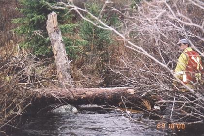
3 Weldwood of Canada Ltd. Rebman Creek Structures Evaluation 1.0 INTRODUCTION The Ministry of Environment, Lands and Parks (MELP), Ministry of Forests (MOF), and Weldwood of Canada Ltd., Quesnel Division (Weldwood), under the BC Watershed Restoration Program (WRP), selected the Willow River Watershed for rehabilitation of fish habitat impaired by logging and related activities. LGL (Ferguson and Bocking, 1998) applied a Level 1 Fish Habitat Assessment Procedure (FHAP) to selected reaches in the Willow River watershed in A sub-watershed, that of tributary Rebman Creek, was identified as having been heavily impacted and of high priority for restoration. In 1999, LGL and Northwest Hydraulic Consultants (Gaboury et al., 1999) followed up with a Level 2 FHAP of Rebman Creek. Restoration efforts were carried out in Rebman Creek on two occasions (LGL and Erosion Control, 1999): in 1998, riffles were constructed along Reach 4; and, in 1999, at a total of 19 sites in Reach 2 and Reach 4, riffle construction continued, pools were excavated upstream of the riffles, and LWD structures built to provide cover and scour at the excavated pools. Under direction from MELP, Weldwood requested G3 Consulting Ltd. (G3) undertake a Site- Based Evaluation of 19 structures built in 1999, following the methodology developed by MELP (Parker, 2000). Results of this audit are reported below. 2.0 STUDY AREA & ACCESS Rebman Creek is a tributary of the Willow River and its watershed has a total area of approximately 21 km 2 (Appendix 1, Figure 1). Rainbow trout (Oncorhynchus mykiss) is a dominant fish species in Rebman Creek and the target of restoration works. The 19 restored sites along Reaches 2 and 4 were accessed by foot from the partially deactivated 900A road that parallels the north (right) bank of Rebman Creek. The access point for Sites 1 to 14 (Reach 2) is situated at approximately UTM , and approximately UTM for sites 15 to 19 (Reach 4) (Appendix 1, Figure 2). 3.0 RESULTS G3 visited each site during bankfull flow, October 23 and 24, The evaluation form used for these assessments is provided in Appendix Riffles Riffles investigated appeared functional in high flow, as each was stable and passable by adult fish. Bank erosion was not evident. Only the riffle downstream of Site 13 was not well keyed into the right bank and a portion of flow went around the top of the riffle. It is recommended that this site be further monitored and boulders be added should erosion continue. No definitive evaluation of functionality under low flow conditions could be made. Some riffles may be too wide and not adequately V-shaped to ensure sufficient water under low flow conditions. 3.2 LWD structures LWD structures investigated appeared stable and firmly anchored. As such, detailed graphic comparisons of such parameters as percent of structures removed, shifted", and in-place to such attributes as stream order and structure location were not deemed necessary.
4 Weldwood of Canada Ltd. Rebman Creek Structures Evaluation Most structures appeared to be functioning as intended (i.e. formation of primary pools [PP] and provision of cover [C]; LGL and Erosion Control, 1999). Residual pools varied from relatively deep (~0.8 m) to shallow (~0.15 m), and in many cases pools could not be assessed as being primary pools according to standard Fish Habitat Assessment Procedures (Johnston and Slaney, 1996). At some sites only an estimate of the number of ballast boulders was possible given high water that increased the safety hazard, high turbidity (low water visibility), and presence of foam. 4.0 RECOMMENDATIONS This audit was conducted during high flows, thereby limiting the ability to evaluate functionality of some structures. It is recommended that similar audits be performed under low flow conditions following at least one high flow event to enable riffle performance to be better assessed and residual pool depths to be more accurately measured. Rehabilitation sites were well marked and documented with photographs. Clearly labelled flagging tape attached to branches indicated vantage points of photos. Unfortunately, UTM coordinates of sites were not provided in previous reports. As coordinates would facilitate later monitoring after markings have deteriorated, it is suggested that coordinates be recorded for future such projects. This audit provided an opportunity to field-test the new audit methodology by Parker (2000), and some modifications may be warranted. In particular, the Assessment Form provided (Appendix 2) was inconsistent with the procedural text and it is therefore recommended that forms and text be adjusted accordingly. It is also recommended that additional information be identified as necessary for collection (as outlined below): 1. Column Structure Location : stream bank (i.e., left or right bank) should be noted with which structures were associated to facilitate future site identification; 2. Column Keyed into Bank (y or n) : as some of the LWD may be keyed into the bank in multilog structures and some may not, it is recommended that the number of keyed-in LWD pieces per structure be recorded. In this audit a y indicates that at least one piece of LWD was keyed into the bank; 3. Column # LWD (<2m & 15 cm) : the heading should read "# LWD >2 m long & >15 cm diameter" (Johnston and Slaney, 1996); 4. Column Associated Scour : the form provides a choice of codes (H, M, L) to describe the extent of the scour, whereas text methodology refers to type of scour pool (Primary, Tertiary, or No). In this audit, both indicators were noted; and 5. the data form should request assessment date, auditor initials, UTM coordinates, and photo documentation records.
5 Weldwood of Canada Ltd. Rebman Creek Structures Evaluation 5.0 LITERATURE SOURCES Johnston, N.T., and P.A. Slaney Fish Habitat Assessment Procedures. Watershed Restoration Technical Circular No. 8. MELP and MOF. Victoria; 97 pp. Ferguson, J., and R. Bocking Willow River Level 1 fish habitat assessment and rehabilitation opportunities. Prepared for Weldwood of Canada Ltd., Quesnel. LGL Limited Environmental Research Associates, Sidney, BC. Gaboury, M., B. Bocking, and K. Rood Willow River Watershed Restoration Program. Fish habitat prescriptions for Rebman Creek. Prepared for Weldwood of Canada Ltd., Quesnel. LGL Limited Environmental Research Associates, Sidney, BC and Northwest Hydraulic Consultants Ltd., North Vancouver, BC. 13 pp. + app. LGL Limited Environmental Research Associates and Erosion Control Inc Willow River Watershed Restoration Program. Stream rehabilitation 1999, as-built report for Rebman Creek. Prepared for MELP, Williams Lake. Sidney, BC (LGL) and Quesnel, BC (ECI); 3 pp. + app. Parker, M.A Cariboo Region in stream structures evaluation, durability and habitat. MELP. Williams Lake; 8 pp. + app.
6 APPENDICES Appendix 1 Figures Appendix 2 Assessment Form Appendix 3 Photo Plates
7 Appendix 1 Figures

8 Figure 1: Level 2 FHAP Reaches in Rebman Creek (Gaboury et al., 1999).
9 Rebman Creek Rehabilitation Sites Left bank LWD structure at 1,440 m and riffle at 1,432 m. 11. Right bank LWD structure at 2,070 m and riffle at 2,065 m. 2. Left bank LWD structure at 1,505 m and riffle at 1,499 m. 12. Left bank LWD structure at 2,096 m and riffle at 2,091 m. 3. Right bank LWD structure at 1,525 m and riffle at 1,520 m. 13. Left bank LWD structure at 2,160 m and riffle at 2,156 m. 4. Right bank LWD structure at 1,590 m and riffle at 1,585 m. 14. Left bank LWD structure at 2,250 m and riffle at 2,249 m. 5. Left bank LWD structure at 1,640 m and riffle at 1,625 m. 15. Right bank LWD structure at 370 m and riffle at 363 m. 6. Right bank LWD structure at 1,660 m and riffle at 1,655 m. 16. Left bank LWD structure at 440 m and riffle at 430 m. 7. Left bank LWD structure at 1,680 m and riffle at 1,675 m. 17. Right bank LWD structure at 466 m and riffle at 458 m. 8. Right bank LWD structure at 1,756 m and riffle at 1,749 m. 18. Right bank LWD structure at 508 m and riffle at 439 m. 9. Left bank LWD structure at 1,930 m and riffle at 1,919 m. 19. Right bank LWD structure at 542 m and riffle at 534 m. 10. Right bank LWD structure at 1,980 m and riffle at 1,975 m. Chainage (m) starting at 0 m from the downstream end of each reach. Chainage (m) in Rebman Creek is based on a 0 m reference at the Rebman Creek Willow River confluence. Figure 2: Rebman Creek Rehabilitation Sites, 1999 (LGL and Erosion Control, 1999)
10 Appendix 2 Assessment Form
11 TABLE 1 Rebman Creek Site Based Evaluation System Stream Order Site Identifier Months Since Installation Structure Location Structure Size Structure Type Ballasted/ Anchored # of boulders/ Ballast Keyed into bank # LWD (>2m & 15 cm) Total LWD Stability Intended Function Intended Functionality Current Function Associated Erosion Associated Scour Habitat Unit Residual Pool (m) Notes Rebman Creek E (LB) H AWD Y ~ 2 Y 3 3 I PP/C S C L P (L) P 0.3 Shallow pool (does not qualify as primary habitat unit) UTM E (LB) H MWD Y 6 Y 4 5 I PP/C S IN L P (H) P existing LWD, 2 LWD added E (RB) H AWD Y 4 Y 2 2 I PP/C I BS, RB eroding between logs, sedimentation M P (L) P 0.15 C, CN inside AWD LWD submerged, one sill log d/s of E (RB) H AWD Y ~ 4 Y 2 3 I PP/C S IN L P (H) P 0.6 structure may be newly deposited (not in as-built photo) E (LB) H MWD Y 10 Y 4 4 I PP/C S C L P (L) P 0.3 Though pool shallow, structure sorts grav el well E (RB) H AWD Y 4 Y 2 2 I PP/C S IN M P (H) P 0.8 Erosion between logs on RB E (LB) H AWD Y 4 Y 3 3 I PP/C S IN L P (H) P 0.6 Cable on u/s log loose and log not held by ballast rock; structure may have shifted E (RB) H MWD Y 7 Y 4 4 I PP/C S IN L P (H) P 0.5 UTM E (LB) H AWD Y 4 Y 2 2 I PP/C S IN L P (M) P 0.4 UTM E (RB) H MWD Y 10 Y 5 6 I PP/C S C L P (L) P 0.3 shallow pool E (RB) H AWD Y ~ 3 Y 3 3 I PP/C S IN L P (H) P E (LB) H AWD Y ~ 2 Y 2 4 I PP/C S IN L P (H) P E (LB) H AWD Y 4 Y 3 3 I PP/C S IN L P (H) P 0.6 some flow around top of riffle (RB): riffle E (LB) H MWD Y 12 Y 5 5 I PP/C S C L P (L) P 0.3 not well keyed in to the RB Log jam d/s of riffle backwatering riffle, UTM E (RB) H AWD Y 4 Y 2 2 I PP/C S C L P (L) P 0.3 shallow pool, UTM E (LB) H MDW Y 12 Y 6 6 I PP/C S IN L P (H) P E (RB) H AWD Y ~ 3 Y 3 3 I PP/C S IN L P (H) P E (RB) H AWD Y 4 Y 3 3 I PP/C S IN L P (H) P E (RB) H MWD Y ~ 8 Y 5 5 I PP/C S IN L P (H) P 0.6 structure totally submerged, BO hard to see!, UTM
12 Appendix 3 Photo Plates


13 Photo 1: Rebman Creek Site 1: left bank LWD structure, Reach 2 at ~1,440 m. Photo 2: Rebman Creek Site 1: view upstream toward constructed riffle, Reach 2 at ~1,432 m.

14 Photo 3: Rebman Creek Site 2: left bank LWD structure, Reach 2 at ~1,505 m.

15 Photo 4: Rebman Creek Site 2: view upstream toward constructed riffle, Reach 2 at ~1,499 m.


16 Photo 5: Rebman Creek Site 3: view upstream toward LWD structure, Reach 2 at ~1,525 m. Photo 6: Rebman Creek Site 3: view upstream toward constructed riffle, Reach 2 at ~1,520 m.


17 Photo 7: Rebman Creek Site 4: view toward left bank LWD structure, Reach 2 at ~1,590 m. Photo 8: Rebman Creek Site 4: view upstream toward constructed riffle, Reach 2 at 1590 m.


18 Photo 9: Rebman Creek Site 5: view downstream toward LWD structure, Reach 2 at ~1,640 m. Photo 10: Rebman Creek Site 5: view upstream toward constructed riffle, Reach 2 at ~1,625 m.


19 Photo 11: Rebman Creek Site 6: view upstream toward LWD structure, Reach 2 at ~1,660 m. Photo 12: Rebman Creek Site 6: view upstream toward constructed riffle and LWD structure, Reach 2 at ~1,655 m.


20 Photo 13: Rebman Creek Site 7: left bank LWD structure, Reach 2 at ~1,680 m. Photo 14: Rebman Creek Site 7: view upstream toward constructed riffle, Reach 2 at ~1,675 m.


21 Photo 15: Rebman Creek Site 8: view upstream toward LWD structure, Reach 2 at ~1,756 m. Photo 16: Rebman Creek Site 8: view upstream toward constructed riffle, Reach 2 at ~1,749 m.


22 Photo 17: Rebman Creek Site 9: view upstream toward LWD structure, Reach 2 at ~1,930 m. Photo 18: Rebman Creek Site 9: view upstream toward constructed riffle, Reach 2 at ~1,920 m.

23 Photo 19: Rebman Creek Site 10: view downstream toward LWD structure, Reach 2 at ~1,980 m.

24 Photo 20: Rebman Creek Site 10: view upstream toward constructed riffle, Reach 2 at ~1,975 m.


25 Photo 21: Rebman Creek Site 11: view upstream toward LWD structure, Reach 2 at ~2,070 m. Photo 22: Rebman Creek Site 11: view upstream toward constructed riffle, Reach 2 at ~2,065 m.


26 Photo 23: Rebman Creek Site 12: left bank LWD structure, Reach 2 at ~2,096 m. Photo 24: Rebman Creek Site 12: view upstream toward constructed riffle, Reach 2 at ~2,091 m.


27 Photo 25: Rebman Creek Site 13: left bank LWD structure, Reach 2 at ~2,160 m. Photo 26: Rebman Creek Site 13: view upstream toward constructed riffle, Reach 2 at ~2,156 m.


28 Photo 27: Rebman Creek Site 14: view upstream toward LWD structure, Reach 2 at ~2,250 m. Photo 28: Rebman Creek Site 15: view downstream toward LWD structure, Reach 4 at ~370 m.

:")
29 Photo 29: Rebman Creek Site 16 (downstream part): view upstream toward constructed riffle, Reach 4 at ~430 m. Photo 30: Rebman Creek Site 16 (downstream part): view upstream toward LWD structure, Reach 4 at ~440 m.

30 Photo 31: Rebman Creek Site 16 (upstream part): view upstream toward LWD structure, Reach 4 at ~445 m. Photo 32: Rebman Creek Site 17: view upstream toward LWD structure, Reach 4 at ~466 m.


31 Photo 33: Rebman Creek Site 18: view upstream toward LWD structure, Reach 4 at ~508 m. Photo 34: Rebman Creek Site 19: view upstream toward LWD structure, Reach 4 at ~542 m.
RE: Engineered Riffle Concepts for Sodom Dam Removal Grade Control Elements
 November 19, 2009 Ms. Melissa Jundt NOAA Fisheries Hydropower Division 1201 NE Lloyd Boulevard, Suite 1100 Portland, Oregon 97232 RE: Engineered Riffle Concepts for Sodom Dam Removal Grade Control Elements
Compensatory Mitigation Monitoring Report Aquatic Habitat Improvement City of Montrose Whitewater Park, Montrose County, Colorado March 6, 2014
 Compensatory Mitigation Monitoring Report Aquatic Habitat Improvement City of Montrose Whitewater Park, Montrose County, Colorado March 6, 2014 i. Project Overview 1. USACE # # SPK 2013 00851 2. Permittee:
San Juan River Watershed: Fish Passage Assessments
 San Juan River Watershed: Fish Passage Assessments Table of Contents 1.0 INTRODUCTION...6 1.1 BACKGROUND... 6 1.2 STUDY AREA... 7 1.3 SCOPE... 7 1.4 ASSUMPTIONS... 7 1.5 LIMITATIONS... 8 1.6 PROJECT SCHEDULE...
Whakapapa River: 2014 Drift Dive Survey. Author: Adam Daniel Publication date: June 6, 2014 Auckland/Waikato Fish and Game Hamilton New Zealand
 Whakapapa River: 2014 Drift Dive Survey Author: Adam Daniel Publication date: June 6, 2014 Auckland/Waikato Fish and Game Hamilton New Zealand 1 SUMMARY Two drift dive surveys were carried out in the headwaters
Re: Survey of constructed cross section per Restoration Framework on Wind River, Fremont County, WY
 1-11-17 LeClair Irrigation District 1418 Cowboy Lane Riverton, WY 82501 (307) 856-4018 Re: Survey of constructed cross section per Restoration Framework on Wind River, Fremont County, WY Dear Mr. Hoelzen,
Technical Memorandum ECO-7
 To: Woody Frossard, TRWD From: Bob Brashear, CDM This document is released for the purpose of interim review under the authority of Robert Brashear, P.E., TX license 80771 on 21-Mar-2005. It is not to
East Chaska Creek Restoration Project
 East Chaska Creek Restoration Project Lower Minnesota River Watershed District & the City of Chaska East Chaska Creek Restoration Project Project No. 86550 February 2016 East Chaska Creek Restoration Project
Memorandum. Application for Amendment to DNR Land Use Permit # LAS29209
 Memorandum Date: September 12, 2013 Project Number: 1992.06k To: From: Subject: cc: Jessica Meybin (ADNR) Tim Sullivan (R2) Application for Amendment to DNR Land Use Permit # LAS29209 Kevin Petrone and
Prepared for Humboldt County Gravel Operators. Prepared by Stillwater Sciences 850 G Street, Suite H Arcata, CA 95521
 2007 Fisheries Monitoring Program Report for Gravel Extraction Operations on the Mad, Lower Eel, South Fork Eel, Van Duzen, and Trinity Rivers, California Prepared for Humboldt County Gravel Operators
Tributary Access and Potential Fish Stranding
 Falls River Project Water Use Plan Tributary Access and Potential Fish Stranding Implementation Year 1 Reference: FLSMON-3 Falls River Water Use Plan Monitoring Program: Tributary Access and Potential
GENERAL DEVELOPMENT APPLICATIONS. General Submission Requirements
 COMPLETE APPLICATION CHECKLIST Jan 2016 The following checklist has been compiled to assist the applicant in preparing their application for approval pursuant to Ontario Regulation 162/06. This checklist
Loy Gulch, Paint Pony, East Fork Paint Pony LOMR
 Loy Gulch, Paint Pony, East Fork Paint Pony LOMR Woodland Park, CO Prepared by: Michael Baker International 165 S. Union Blvd, Suite 200 Lakewood, CO 80226 TABLE OF CONTENTS I. INTRODUCTION... 2 1.1 Purpose...
KKR S. 6 th St. to I-94 Bridge Project Location. Expanded Floodplains
 Kinnickinnic River Watercourse Rehabilitation Early Out Project Achieving Multiple Design Objectives Thomas R. Sear, PE, CFM Short Elliott Hendrickson Patrick C. Elliott, PE Milwaukee Metropolitan Sewerage
Guide to Developing a Stream Photograph Documentation Program
 Guide to Developing a Stream Photograph Documentation Program William Robertson: MSUEWQ & BSWC Introduction Landscape photographs can offer a qualitative and, in some situations, quantitative evaluation
Table of Contents. Chapter 1.0 Purpose and Need
 Table of Contents Chapter 1.0 Purpose and Need CHAPTER 1.0 PURPOSE AND NEED... 1 1.1 INTRODUCTION... 1 1.1.1 EA ORGANIZATION... 1 1.2 PROJECT AREA... 1 1.3 PROPOSED ACTION... 2 1.3.1 SCOPE OF THE PROPOSED
LOWER YUBA RIVER ACCORD MONITORING
 LOWER YUBA RIVER ACCORD MONITORING AND EVALUATION PROGRAM AERIAL MAPPING OF STREAMWOOD AND HUMAN- BUILT DETRITUS AVAILABLE AS COVER IN THE LOWER YUBA RIVER IN AUTUMN 2008 MAY 9, 2014 (Aerial photo of a
B422 - PRECAST REINFORCED CONCRETE BOX CULVERTS AND BOX SEWERS - OPSS 422
 B422 - PRECAST REINFORCED CONCRETE BOX CULVERTS AND BOX SEWERS - OPSS 422 422.1 GENERAL The work under these tender items consists of the fabrication and installation in open cut of precast reinforced
APPENDIX E - FLOODPLAIN INFORMATION
 CITY OF WOODLAND PARK STORMWATER MASTER PLAN - Floodplain Information APPENDIX E - FLOODPLAIN INFORMATION E1 - Floodplain Information TABLE OF CONTENTS I. INTRODUCTION... 2 Loy Gulch, Paint Pony, East
Make Your Own Monitoring Equipment
 Make Your Own Monitoring Equipment Stadia Rod A stadia rod is used to take depth measurements in a stream channel. With this rod you can measure in both metric and English systems. You can also take length
Pilot Project Ross Valley Watershed Geomorphology GIS Database Final Report August 30, 2010
 Pilot Project Ross Valley Watershed Geomorphology GIS Database Final Report August 30, 2010 Prepared by: Gerhard Epke 2010 Watershed Intern (831) 332-1324 24 Bolinas Ave San Anselmo, CA 94960 Supervised
The Basics. HECRAS Basis Input. Geometry Data - the basics. Geometry Data. Flow Data. Perform Hydraulic Computations. Viewing the Output
 The Basics HECRAS Basis Input Geometry Data. Flow Data. Perform Hydraulic Computations by G. Parodi WRS ITC The Netherlands Viewing the Output ITC Faculty of Geo-Information Science and Earth Observation
Methods for characterization of freshwater turtle nesting beaches in an urban environment
 Methods for characterization of freshwater turtle nesting beaches in an urban environment Nicole Richards MES candidate, York University In Collaboration with the Toronto Zoo The Plight of Urban Turtles
State Listed Threatened Mussels and Zebra Mussels: What You Need to Know
 State Listed Threatened Mussels and Zebra Mussels: What You Need to Know Texas Association of Environmental Professionals May Luncheon Houston, Texas May 21, 2015 GENERAL OUTLINE Native Mussels Lifecycle
MAPPING YOUR STREAM. TIME REQUIRED 50 minutes in Field 50 minutes in Classroom 50 minutes Homework
 OUR MAPPING YOUR STREAM STREAM ACTIVITY SUMMARY Students will draft a cross-sectional profile of the stream and measure the velocity of the current. They will use both of these to calculate the discharge
FLOOD ESTIMATE FROM POSSIBLE DAM BREAK SCENARIO OF SUN KOSI LAND SLIDE DAM, NEPAL. O. P. GUPTA Director Central Water Commission
 FLOOD ESTIMATE FROM POSSIBLE DAM BREAK SCENARIO OF SUN KOSI LAND SLIDE DAM, NEPAL by O. P. GUPTA Director Central Water Commission Introduction Landslide dams are natural phenomenon that poses a major
Susitna-Watana Hydroelectric Project (FERC No )
") (FERC No. 14241) Fish Distribution and Abundance in the Upper and Middle/Lower Susitna River (Studies 9.5 and 9.6): Draft Chinook and Coho Salmon Identification Protocol Prepared for Prepared by R2 Resource
(FERC No. 14241) Fish Distribution and Abundance in the Upper and Middle/Lower Susitna River (Studies 9.5 and 9.6): Draft Chinook and Coho Salmon Identification Protocol Prepared for Prepared by R2 Resource
ENSURING LONGITUDINAL CONNECTIVITY OF THE JIU RIVER NEAR ISALNITA DAM
 Water resources and wetlands, Editors: Petre Gâştescu, William Lewis Jr., Petre Breţcan Conference Proceedings, 14-16 September 2012, Tulcea - Romania ISBN: 978-606-605-038-8 ENSURING LONGITUDINAL CONNECTIVITY
Amgueddfa Cymru National Museum Wales. Collection Care & Conservation Policy
 Approved by Amgueddfa Cymru National Museum Wales Board of Trustees 15 December 2016 1. Introduction Amgueddfa Cymru National Museum Wales Collection Care & Conservation Policy 1.1 Amgueddfa Cymru holds
MONTHLY UPDATE REPORT - PRIMROSE SOUTH W4M OCTOBER 7, 2013
 MONTHLY UPDATE REPORT - PRIMROSE SOUTH 09-21-067-04 W4M OCTOBER 7, Introduction The Primrose South in situ oil sands project is located in the Cold Lake Air Weapons Range approximately 65 km north-northeast
Tiered Species Habitats (Terrestrial and Aquatic)
") Tiered Species Habitats (Terrestrial and Aquatic) Dataset Description Free-Bridge Area Map The Department of Game and Inland Fisheries (DGIF s) Tiered Species Habitat data shows the number of Tier 1, 2
Tiered Species Habitats (Terrestrial and Aquatic) Dataset Description Free-Bridge Area Map The Department of Game and Inland Fisheries (DGIF s) Tiered Species Habitat data shows the number of Tier 1, 2
Performance Monitoring
 Performance Monitoring Rock Island District Kara N. Mitvalsky, P.E. CEMVR-EC-DN Traditional Reports Analysis of existing data Comparison of data points to objectives identified in the feasibility reports
UPPER MISSISSIPPI RIVER RESTORATION LAKE ODESSA HABITAT REHABILITATION AND ENHANCEMENT PROJECT OPERATION AND MAINTENANCE MANUAL APPENDIX F
 UPPER MISSISSIPPI RIVER RESTORATION LAKE ODESSA HABITAT REHABILITATION AND ENHANCEMENT PROJECT OPERATION AND MAINTENANCE MANUAL APPENDIX F PROJECT PHOTOGRAPHS Table of Photographs Photograph 1: Lake Odessa
SITE: NAKWASINA RIVER BARANOF ISLAND, SOUTHEAST ALASKA
 2014 field notes SITE: NAKWASINA RIVER BARANOF ISLAND, SOUTHEAST ALASKA Latitude: N 57.25802 Longitude: W 135.32940 Waypoint ID: 20110720-NAK AWC stream no. 113-43-10010 Scott Harris, scott@sitkawild.org
2/15/2015. Current will always try to return to its source. In order for there to be current, there must be a complete circuit
 Current will always try to return to its source In order for there to be current, there must be a complete circuit Current will take as many paths or circuits available to it to return to the source The
TECHNICAL NOTE - PARALLEL CHANNEL INSTALLATION AND MAINTENANCE GUIDELINES - PYRAMAT 25
 PARALLEL CHANNEL GUIDELINES-PYRAMAT 25 Thank you for purchasing the Pyramat 25 Turf Reinforcement Mat (TRM) by Propex Operating Company, LLC (Propex). This document provides installation and maintenance
2011 Mountain Yellow-legged Frog Monitoring Plan Survey Results El Dorado Hydroelectric Project, FERC No. 184
 2011 Mountain Yellow-legged Frog Monitoring Plan Survey Results El Dorado Hydroelectric Project, FERC No. 184 February 2012 Prepared For: El Dorado Irrigation District 2890 Mosquito Road Placerville, California
Black-crowned Night-heron Minnesota Conservation Summary
 Credit Deborah Reynolds Black-crowned Night-heron Minnesota Conservation Summary Audubon Minnesota Spring 2014 The Blueprint for Minnesota Bird Conservation is a project of Audubon Minnesota written by
Supporting Guidance Note
 Supporting Guidance Note Supporting Guidance Note: SGN 2 Geomorphology photosurveys for hydropower developments We require a geomorphology photosurvey to be submitted with applications for abstraction
REMOTE SENSING OF RIVERINE WATER BODIES
 REMOTE SENSING OF RIVERINE WATER BODIES Bryony Livingston, Paul Frazier and John Louis Farrer Research Centre Charles Sturt University Wagga Wagga, NSW 2678 Ph 02 69332317, Fax 02 69332737 blivingston@csu.edu.au
B. Project Summary: Audubon Arkansas will work on assessment and restoration of aquatic habitats in urban environments in Central Arkansas.
 A. Title of Project: Assessment and Restoration of Aquatic Habitats in Central Arkansas B. Project Summary: Audubon Arkansas will work on assessment and restoration of aquatic habitats in urban environments
ATTACHMENT H TACOMA HYDROELECTRIC PROJECT DESCRIPTION OF PROJECT FEATURES
 ATTACHMENT H TACOMA HYDROELECTRIC PROJECT DESCRIPTION OF PROJECT FEATURES The Tacoma Hydroelectric Project is located about 20 miles north of Durango, Colorado, on a high intermountain plateau west of
Log Scanning Trials. Peter Dyson Researcher FPInnovations Forest Operations Division. Location: Date: Bellingham
 Log Scanning Trials Peter Dyson Researcher FPInnovations Forest Operations Division Location: Date: Bellingham April 11, 2013 Presentation Outline 1. Introduction to laser log scanning. 2. Canadian Standards
AERIAL SURVEY OF BIRDS AT MONO LAKE ON AUGUST 24, 1973
 AERIAL SURVEY OF BIRDS AT MONO LAKE ON AUGUST 24, 1973 by Ronald M. Jurek Special Wildlife Investigations Wildlife Management Branch California Department of Fish and Game September 1973 Jurek, R.M. 1973.
Harlequin Duck Histrionicus histrionicus distribution and stonefly nymph availability in the Maligne Valley watershed a preliminary study
 75 Harlequin Duck Histrionicus histrionicus distribution and stonefly nymph availability in the Maligne Valley watershed a preliminary study N.A. McCutchen 1 & R.C. Ydenberg 2 1 Department of Biological
Colorado Parks and Wildlife (CPW) Wetlands Program 2016 Grant Awards
 Wetlands Program 2016 Grant Awards") Colorado Parks and Wildlife (CPW) Wetlands Program 2016 Grant Awards Grant awards = 23 Wetland/riparian acres impacted = 3,828 State Wildlife Areas (SWA) impacted = 7 Priority Waterfowl Species Benefitting
Colorado Parks and Wildlife (CPW) Wetlands Program 2016 Grant Awards Grant awards = 23 Wetland/riparian acres impacted = 3,828 State Wildlife Areas (SWA) impacted = 7 Priority Waterfowl Species Benefitting
Ecological Restoration Drafting & Design Guidelines
 Ecological Restoration Drafting & Design Guidelines Version 2.0 July 2017 Philadelphia Water Ecological Restoration Drafting & Design Guidelines Table of Contents 1.0 INTRODUCTION...2 2.0 GENERAL PLAN
Mountain Yellow-Legged Frog Monitoring Plan
 El Dorado Hydroelectric Project FERC Project No. 184 Mountain Yellow-Legged Frog Monitoring Plan EL DORADO IRRIGATION DISTRICT 2890 Mosquito Road Placerville, CA 95667 December 2010 Version 2.0 This study
Mystic Lake Hydroelectric Project FERC Project Number Year Bald Eagle Monitoring Summary Report Public
 Mystic Hydroelectric Project FERC Project Number 2301 3-Year Bald Eagle Monitoring Summary Report 2010-2013 Public 2013 by PPL Montana, LLC. ALL RIGHTS RESERVED Submitted to: Federal Energy Regulatory
Current Water Quality Conditions and Initial Documentation of Hydrilla (Hydrilla verticillata) in Harveys Lake, Luzerne County, PA
 in Harveys Lake, Luzerne County, PA") Current Water Quality Conditions and Initial Documentation of Hydrilla (Hydrilla verticillata) in Harveys Lake, Luzerne County, PA New York State Federation of Lake Associations 4 th 5 th May 2018 Fred
Current Water Quality Conditions and Initial Documentation of Hydrilla (Hydrilla verticillata) in Harveys Lake, Luzerne County, PA New York State Federation of Lake Associations 4 th 5 th May 2018 Fred
CHARTER ON THE PROTECTION AND MANAGEMENT OF UNDERWATER CULTURAL HERITAGE (1996)
") CHARTER ON THE PROTECTION AND MANAGEMENT OF UNDERWATER CULTURAL HERITAGE (1996) Ratified by the 11th ICOMOS General Assembly in Sofia, Bulgaria, October 1996. INTRODUCTION This Charter is intended to encourage
CHARTER ON THE PROTECTION AND MANAGEMENT OF UNDERWATER CULTURAL HERITAGE (1996) Ratified by the 11th ICOMOS General Assembly in Sofia, Bulgaria, October 1996. INTRODUCTION This Charter is intended to encourage
Iowa Bridge Sensor Demonstration Project Phase I and Phase II Executive Summary Report. Floodplain Management Services Silver Jackets Pilot Study
 Iowa Bridge Sensor Demonstration Project Phase I and Phase II Executive Summary Report Floodplain Management Services Silver Jackets Pilot Study Final Report AUGUST 2016 Iowa Bridge Sensor Demonstration
Appendix C Photo Plates
 Appendix C Photo Plates Photo Plate 1 Site E1 Ravelling cutslope has infilled the culvert inlet Photo Plate 3 Site E1 Ravelling cutslope Photo Plate 2 Site E1 Damaged culvert inlet Photo Plate 4 Site E1
King Road / CN Rail Grade Separation
 King Road / CN Rail Grade Separation A perfect confluence of environmental collaboration Project Proponents: Designers: Regulator: City of Burlington AMEC Environment & Infrastructure Conservation Halton
Fall Trumpeter Swan Survey of the High Plains Flock
 University of Nebraska - Lincoln DigitalCommons@University of Nebraska - Lincoln US Fish & Wildlife Publications US Fish & Wildlife Service 10-2009 Fall Trumpeter Swan Survey of the High Plains Flock Shilo
Bald Eagle Annual Report February 1, 2016
 Bald Eagle Annual Report 2015 February 1, 2016 This page intentionally blank. PROJECT SUMMARY Project Title: Bald Eagle HCP Monitoring Subject Area: Habitat Conservation Plan (HCP) monitoring Date initiated:
DS1 Storm - Sill System: ASSEMBLY MANUAL
 Exterior Folding Door Systems DS1 Storm - Sill System: ASSEMBLY MANUAL For 4-9/16 (116mm), 6-9/16 (167mm) & 7-1/4 (184mm) Sills For Single Door Openings, Inswing Application D DOOR (single) INSWING www.thedsgroup.com
Evaluation of an Electrical Gradient as a Seal Deterrent Puntledge River Study, April 10 24, 2007 Preliminary Results
 Evaluation of an Electrical Gradient as a Seal Deterrent Puntledge River Study, April 10 24, 2007 Preliminary Results From April 10 25, 2007, staff from the Pacific Salmon Commission (PSC), Department
Field Observations and One-Dimensional Flow Modeling of Summit Creek in Mack Park, Smithfield, Utah
 Sediment Transport Workshop, Utah State University, 1 August 2017 Field Observations and One-Dimensional Flow Modeling of Summit Creek in Mack Park, Smithfield, Utah I. Goals for learning and discussion:
NECESSITY IS THE MOTHER OF INVENTION I. INTRODUCTION
 NECESSITY IS THE MOTHER OF INVENTION M. Leslie Boyd, P.E., Freese and Nichols, Inc Mike Lowe, P.E., Lower Colorado River Authority Dustin Mortensen, P.E., Freese and Nichols, Inc. I. INTRODUCTION When
Analysis of Reference Tidal Channel Plan Form For the Montezuma Wetlands Restoration Project
 Analysis of Reference Tidal Channel Plan Form For the Montezuma Wetlands Restoration Project Sarah Pearce, Geomorphologist Joshua N. Collins, Project Manager Contribution No. 80 May, 2004 ACKNOWLEDGEMENTS
Introduction of The Iraqi Marshlands
 Introduction of The Iraqi Marshlands Urgent needs for the long-term sustainable management Dr Ali Al-Lami Advisor to the Minister Ministry of Environment, Republic of Iraq 1 CBD COP10 side event for Long-term
STROLLING FOR CERULEANS & ASSOCIATED SPECIES AVIAN LINE TRANSECT PROTOCOL
 STROLLING FOR CERULEANS & ASSOCIATED SPECIES AVIAN LINE TRANSECT PROTOCOL (BORROWED & MODELED AFTER AVIAN LINE TRANSECT PROTOCOL SHENANDOAH NATIONAL PARK) 1 BACKGROUND/RATIONALE Artwork by Gabriella Martinez
GPS Surveying Procedures
 GPS Surveying Procedures 5.1 Purpose The purpose of this SHIM Module is to provide guidelines for field and office procedures, and data standards for watercourse mapping using Global Positioning System
A B C D E F G H SEE NOTE 1 EL (MIN.) 2 NEW UNCOMPACTED EL. VARIES EARTH EMBANKMENT 3 (MIN.) TYPICAL SECTION EMBANKMENT AND BORROW 6 (MIN.
 2 NEW UNCOMPACTED EL. VARIES EARTH EMBANKMENT 3 (MIN.) TYPICAL SECTION EMBANKMENT AND BORROW 6 (MIN.") BORROW AS NECESSARY TO CONSTRUCT RIVERWARD SEE NOTE EL.. (MIN.) (MIN.) NEW UNCOMPACTED EL. EARTH C L C C C TYPICAL SECTION AND BORROW NO SCALE. CDF FLAT POOL EL.. JULJRP/REH AS CONSTRUCTED Approved Description
BORROW AS NECESSARY TO CONSTRUCT RIVERWARD SEE NOTE EL.. (MIN.) (MIN.) NEW UNCOMPACTED EL. EARTH C L C C C TYPICAL SECTION AND BORROW NO SCALE. CDF FLAT POOL EL.. JULJRP/REH AS CONSTRUCTED Approved Description
Presented By: Todd Ward Project Manager
 Presented By: Todd Ward Project Manager Mailing Address All submittals for LOMRs and CLOMRs Harris County should be directed to Harris County Flood Control District. Submittals can be mailed or hand-delivered
MARSH MONITORING PROGRAM: 2003 VOLUNTEER HABITAT WORKSHOP SUMMARY
 MARSH MONITORING PROGRAM: 2003 VOLUNTEER HABITAT WORKSHOP SUMMARY Prepared for Canadian Wildlife Service Environmental Conservation Branch Ontario Region Environment Canada by Tara L. Crewe and Steven
TO: FROM SUBJECT: SRBA Jon Albright Technical Memorandum on Hydrologic Yields PROJECT: Sulphur River Basin Feasibility Study DATE: 08/26/2014 CC:
 593 Summerhill Rd Texarkana, Texas 7553 93-838-8533 fax 93-832-47 TO: FROM SUBJECT: PROJECT: SRBA Jon Albright Technical Memorandum on Hydrologic Yields Sulphur River Basin Feasibility Study DATE: 8/26/214
Population Estimate and Size Comparison of Orconectes propinquus in Riffle Habitats in Tenderfoot Creek
 Population Estimate and Size Comparison of Orconectes propinquus in Riffle Habitats in Tenderfoot Creek BIOS 35502: Practicum in Field Biology Ashley Baca Advisor: Dr. Todd Crowl 2010 Abstract: Orconectes
Black Lake SLELO-PRISM Water Chestnut & Hydrilla Surveillance 2012
 St. Lawrence Eastern Lake Ontario Partnership for Regional Invasive Species Management Black Lake Water Chestnut & Hydrilla Surveillance 2012 June 8, 11, 12 & 14 (Water Chestnut); August 8 (Hydrilla),
Cattle-Free for 10 Years!
 Cattle-Free for 10 Years! Big Whitney Meadow after a Decade of Rest From Cattle Impact Photographs and text produced by Todd Shuman, August, 2011. For more information, email Todd at tshublu@yahoo.com
Freshwater Stream Conditions in the Patuxent River Basin
 Freshwater Stream Conditions in the Patuxent River Basin Dan Boward, Michael Kashiwagi and Andy Becker Patuxent River Conference June 18-19, 2015 Information Sources Maryland Biological Stream Survey Fish/Benthic
RADAR-BASED OPEN CHANNEL FLOW MEASUREMENT. Lawrence B. Marsh President Marsh-McBirney Inc Metropolitan Court Frederick, MD 21704
 RADAR-BASED OPEN CHANNEL FLOW MEASUREMENT ABSTRACT Lawrence B. Marsh President Marsh-McBirney Inc. 4539 Metropolitan Court Frederick, MD 21704 This article is provided Courtesy of Winston Tang, M.A.Sc.
Electrical Procedure No E032. Procedure No: ELE 032
 Procedure No: ELE 032 Procedure Title: Date of Procedure: Responsible Person(s) Safety Isolation of Low Voltage Networks and Systems for work to be carried out by third parties. i.e. Non University personnel.
GEOPHYSICAL REPORT on the ZIP 1 MINERAL CLAIM ATLIN M.D.
 ., GEOPHYSICAL REPORT on the ZIP 1 MINERAL CLAIM ATLIN M.D. N.T.S. 1040/5E Long. 131 36' August 1-3 1980 Falconbridge Nickel Mines Limited. Vancouver, B. C. October, 1980 B. W. Downing. TABLE OF CONTENTS
GOODLIGHT LP Post Construction Monitoring Report Goodlight Solar Project
 GOODLIGHT LP Post Construction Monitoring Report Goodlight Solar Project A Monitoring Report in accordance with the commitments outlined in the project Natural Heritage Assessment. i Table of Contents
Example Application C H A P T E R 4. Contents
 C H A P T E R 4 Example Application This chapter provides an example application of how to perform steady flow water surface profile calculations with HEC-RAS. The user is taken through a step-by-step
Nevada Sagebrush Ecosystem Conservation Program
 Nevada Sagebrush Ecosystem Conservation Program Managing approximately 1.8 million acres for multiple uses, including mineral exploration and mining, rangeland livestock production, and ecosystem restoration.
British Columbia. Dancing Quilts 195B Birch Avenue 100 Mile House BC V0K 2G
 Dancing Quilts 195B Birch Avenue 100 Mile House BC V0K 2G0 250-395-4227 A Great Notion Sewing Supply Ltd. 101-32526 George Ferguson Way Abbotsford BC V2T 4Y1 604-853-8930 Pleasant Valley Quilting 3495
MARINE GEOPHYSICAL PROVE-OUT AND SURVEY AT FLAG LAKE BOMBING RANGE BARKSDALE AIR FORCE BASE, LOUISIANA
 MARINE GEOPHYSICAL PROVE-OUT AND SURVEY AT FLAG LAKE BOMBING RANGE BARKSDALE AIR FORCE BASE, LOUISIANA Garrick Marcoux 1, Wallace Robertson 2, Boban Stojanovic 1, Jeffrey B. Hackworth 1 1 FPM Geophysical
Marine Renewable-energy Application
 Marine Renewable-energy Application OFFICE USE ONLY Date Received: Application #: Time Received: Date of Complete Application: Received by: Processed by: Type of Application Permit (unconnected) Permit
2004 Ipswich River Herring Count by Ipswich River Watershed Association Kerry Mackin, Executive Director
 2004 Ipswich River Herring Count by Ipswich River Watershed Association Kerry Mackin, Executive Director Alewife (Alosa pseudoharengus) Blueback Herring (Alosa aestivalis) Illustrations Source: Kraft,
Roberts Bank Terminal 2 Project Field Studies Information Sheet
 May 2013 Port Metro Vancouver is continuing field studies in May as part of ongoing environmental and technical work for the proposed Roberts Bank Terminal 2 Project. Roberts Bank Terminal 2 Project The
UNITED STATES DEPARTMENT OF THE INTERIOR BUREAU OF LAND MANAGEMENT WASHINGTON, D.C October 23, 2003
 UNITED STATES DEPARTMENT OF THE INTERIOR BUREAU OF LAND MANAGEMENT WASHINGTON, D.C. 20240 October 23, 2003 EMS TRANSMISSION 10/23/2003 Instruction Memorandum No. 2003-275 Change 1 Expires: 09/30/2004 In
How to Take RBV Site Photographs
 How to Take RBV Site Photographs CTDEEP RBV Program www.ct.gov/deep/rbv Last revised 08/16/2016 Connecticut Department of Energy and Environmental Protection How to Take RBV Site Photographs Directions:
ODFW Life Cycle Monitoring Project
 ODFW Life Cycle Monitoring Project Background and Potential as Intensively Monitored Watersheds Erik Suring . Necanicum Lower Nehalem Upper Nehalem Nehalem Scappoose River Scappoose LCM Background Cummins
Wood Stork Aerial Survey Trip Report. Lake Murray and Saluda River August 27, Aircraft: Fixed-Wing Cessna 210 Survey Duration: hrs
 Survey Attendees Shane Boring Tom Murphy Bucky Harris Kleinschmidt SCDNR Endangered Species Biologist SCDNR Pilot Aircraft: Fixed-Wing Cessna 210 Survey Duration: 1300 1415 hrs Survey Observations The
Anne Johnson U.S. Government Accountability Office. Association of Food and Drug Officials 116 th Annual Educational Conference June 3, 2012
 Anne Johnson U.S. Government Accountability Office Association of Food and Drug Officials 116 th Annual Educational Conference June 3, 2012 GAO s Role Help Congress ensure that the federal government is
Green Star Daylight and Views Hand Calculation Guide
 Green Star Daylight and Views Hand Calculation Guide 12 May 2015 Changelog Date Version Change 16 th Sept 2013 0.1 Draft Issued for Comment 12 th May 2015 0.2 Included guidance on calculating views Contents
Technical Requirements for Wireless Broadband Services (WBS) in the Band MHz
 in the Band MHz") Issue 2 June 2010 Spectrum Management and Telecommunications Standard Radio System Plan Technical Requirements for Wireless Broadband Services (WBS) in the Band 3650-3700 MHz Aussi disponible en français
Issue 2 June 2010 Spectrum Management and Telecommunications Standard Radio System Plan Technical Requirements for Wireless Broadband Services (WBS) in the Band 3650-3700 MHz Aussi disponible en français
SUBMISSION ON PLAN CHANGE 34 (LAKE TAUPO EROSION AND FLOOD STRATEGY): BY NGATI KURAUIA HAPŪ.
: BY NGATI KURAUIA HAPŪ.") SUBMISSION ON PLAN CHANGE 34 (LAKE TAUPO EROSION AND FLOOD STRATEGY): BY NGATI KURAUIA HAPŪ. Map 1: Ngāti Kurauia Customary Area of Interest SUMMARY OF KEY SUBMISSION POINTS: 1) Land ownership of Ngati
SUBMISSION ON PLAN CHANGE 34 (LAKE TAUPO EROSION AND FLOOD STRATEGY): BY NGATI KURAUIA HAPŪ. Map 1: Ngāti Kurauia Customary Area of Interest SUMMARY OF KEY SUBMISSION POINTS: 1) Land ownership of Ngati
erosion control HasTec KGW 400 advantages: usage: For surface protection and greening of slopes in landscaping and traffic route engineering.
 HasTec KGW 400 For surface protection and greening of slopes in landscaping and traffic route engineering. Surface covered with HasTec KGW 400. Fixing with nails of wood or steel (suggestion: 2-4 pieces
In response to a request from Water Rights Branch, a short. In general, the sequence of post glacial events in the immediate. D. M.
 . TO Dr. J. C. Foweraker......!...... C&* Groundwater Div i s ion... GOVERNMENT OF BRITISH COLUMBIA M EM0 RAN DU M D. M. Callan Groundwater Division... July 6th... 19... 71... SUBJECT GROUNDWATER INVESTIGATION
Photopoint Identification Sheet Page 1 of 2
 Photopoint Identification Sheet Page 1 of 2 Site Name: Cebolla Canyon; El Malpais National Conservation Area, BLM Recorder s name: Matt Schultz Date of survey:11/5/09 Photographer s name: Matt Schultz
Roberts Bank Terminal 2 Project Field Studies Information Sheet
 January 2013 Port Metro Vancouver is continuing field studies in January as part of ongoing environmental and technical work for the proposed. The is a proposed new multi berth container terminal which
French Fire Contaminants Assessment: Preliminary Report, September 2005
 Interagency Burned Area Emergency Stabilization and Rehabilitation Plan French Fire Contaminants Assessment: Preliminary Report, September Prepared by: Jason May and Larry Brown, U.S. Geological Survey,
Project Title: Lewis Woodpecker Nesting Box FWCP: COL-F17-W Prepared for: Fish and Wildlife Compensation Program. Prepared by: Richard Hoar
 Project Title: Lewis Woodpecker Nesting Box FWCP: COL-F17-W-1219 Prepared for: Fish and Wildlife Compensation Program Prepared by: Richard Hoar Prepared with financial support of the Fish and Wildlife
SECTION DEWATERING TANKAGE PART 1 - GENERAL 1.1 RELATED DOCUMENTS
 SECTION 31 23 19 - DEWATERING TANKAGE PART 1 - GENERAL 1.1 RELATED DOCUMENTS A. Drawings and general provisions of the Contract, including General and Supplementary Conditions and Division 1 Specification
Environmental Working Group. Monthly Report
 Monthly Report September 2014 ENVIRONMENTAL WORKING GROUP Relationship Organizational Chart Weekly (EWG) and EWG/Kiewit Alarie, a Partnership (KAP) meetings. The EWG review its Action Items that include
Relicensing Study 3.5.1
 Relicensing Study 3.5.1 BASELINE INVENTORY OF WETLAND, RIPARIAN AND LITTORAL HABITAT IN THE TURNERS FALLS IMPOUNDMENT, AND ASSESSMENT OF OPERATIONAL IMPACTS ON SPECIAL-STATUS SPECIES Updated Study Report
Roberts Bank Terminal 2 Project Field Studies Information Sheet
 July 2012 Port Metro Vancouver is continuing field studies in July as part of ongoing environmental and technical work for the proposed Roberts Bank Terminal 2 Project. Roberts Bank Terminal 2 Project