Prepared for Humboldt County Gravel Operators. Prepared by Stillwater Sciences 850 G Street, Suite H Arcata, CA 95521
|
|
|
- Lambert Taylor
- 5 years ago
- Views:
Transcription
1 2007 Fisheries Monitoring Program Report for Gravel Extraction Operations on the Mad, Lower Eel, South Fork Eel, Van Duzen, and Trinity Rivers, California Prepared for Humboldt County Gravel Operators Prepared by Stillwater Sciences 850 G Street, Suite H Arcata, CA August 2008
2 2007 Humboldt County Gravel Extraction Fisheries Monitoring Report Stillwater Sciences Fisheries monitoring program report for gravel extraction operations on the Mad, Eel, South Fork Eel, Van Duzen, and Trinity rivers, California. Prepared by Stillwater Sciences, Arcata, California for Humboldt County Gravel Operators. 27 August 2008 Stillwater Sciences i
3 2007 Humboldt County Gravel Extraction Fisheries Monitoring Report Table of Contents 1 INTRODUCTION METHODS RESULTS AND DISCUSSION Mad River Lower Eel River South Fork Eel River Van Duzen River Trinity River REFERENCES...14 List of Tables Table 2-1. Companies participating in the biological monitoring program... 3 Table 3-1. Lengths and percentages for Mad River pool:riffle:flatwater habitat units Mad River Hatchery to the lower end of the O Neill Bar Table 3-2. Mad River pool depths for Mad River Hatchery to the O Neill Bar... 5 Table 3-3. Mad River salmonid habitat areas for Mad River Hatchery to the O Neill Bar... 6 Table 3-4. Lower Eel River pool:riffle:flatwater lengths and percentages for mouth of the Van Duzen River to Fernbridge... 7 Table 3-5. Lower Eel River pool depths for mouth of the Van Duzen River to Fernbridge Table 3-6. Lower Eel River mapped habitat unit areas for mouth of the Van Duzen River to Fernbridge... 9 Table 3-7. South Forth Eel River pool:riffle:flatwater lengths and percentages for Table 3-8. South Fork Eel River pool depths for Table 3-9. South Fork Eel River mapped habitat unit areas for Table Van Duzen River pool:riffle:flatwater lengths and percentages Table Van Duzen River pool depths for Table Lower Van Duzen River mapped habitat unit areas for Table Trinity River pool:riffle:flatwater lengths and percentages for Table Trinity River mapped habitat unit areas for List of Appendices Appendix A. Delineated Aerial Photographs Mad River Appendix B. Delineated Aerial Photographs Lower Eel River Appendix C. Delineated Aerial Photographs South Fork Eel River Appendix D. Delineated Aerial Photographs Van Duzen River Appendix E. Delineated Aerial Photographs Trinity River 27 August 2008 Stillwater Sciences ii
4 2007 Humboldt County Gravel Extraction Fisheries Monitoring Report 1 INTRODUCTION AND BACKGROUND Many northern California rivers draining areas underlain by Franciscan formation geology contain low-gradient depositional reaches that contain vast stores of cobble, gravel, and sand. The lower reaches of several of these rivers are currently being utilized to provide gravel-based products, such as concrete and asphalt, for a variety of public and private construction projects. These operations provide a valuable commodity necessary for the construction and maintenance of communities and infrastructure. Commercial gravel removal operations have occurred on the depositional reaches of rivers and creeks in Humboldt County since at least the 1950s. Extraction generally occurs on gravel deposits that have been annually replenished during the winter runoff. Because fish utilize the waterways where gravel is extracted from exposed bar surfaces, there is a heightened concern about the potential impacts these operations may have on the fishery resources. This is especially true given the Endangered Species Act (ESA) threatened listings and critical habitat designations for coho salmon (Oncorhynchus kisutch), Chinook salmon (O. tshawytscha), and steelhead trout (O. mykiss). Since 1997, the commercial gravel operators in Humboldt County have conducted fisheries monitoring activities as a requirement of the U.S. Army Corps of Engineers (USACE) Letter of Permission (LOP), Humboldt County Interim Monitoring Program (IMP), and individual Clean Water Act Section 404 permits. The terms and conditions of the biological opinions (National Marine Fisheries Service [NMFS] 2004a, 2004b) that cover gravel-mining activities in Humboldt County require monitoring to track habitat conditions for listed salmonids. As described in the biological opinions (NMFS 2004a, 2004b), the current monitoring program was developed collaboratively between the involved agencies and gravel mining companies. NMFS met with local and state agencies and companies in December 2004 and January 2005 to begin the collaborative process. In March 2005, NMFS sent out a draft monitoring plan for review and comment, and in June 2005, NFMS met with agencies and applicants to discuss and incorporate the comments. The current monitoring program was finalized and implemented in September The intent of the habitat monitoring effort is two-fold. The first is to maintain continuity from past habitat mapping efforts and record the distribution and characteristics of habitat units that provide fish habitat value, such as pool, riffles, and flatwaters. The second objective of the monitoring is to identify and quantify specific life history habitat parameters over time. This requires the identification and delineation of specific instream habitat units critical for spawning, rearing, and holding adult and juvenile salmonids. This monitoring report details the results of the 2007 biological monitoring program for instream gravel extraction operations on the Mad, Eel, South Fork Eel, Van Duzen, and Trinity rivers in Humboldt County. 27 August 2008 Stillwater Sciences 1
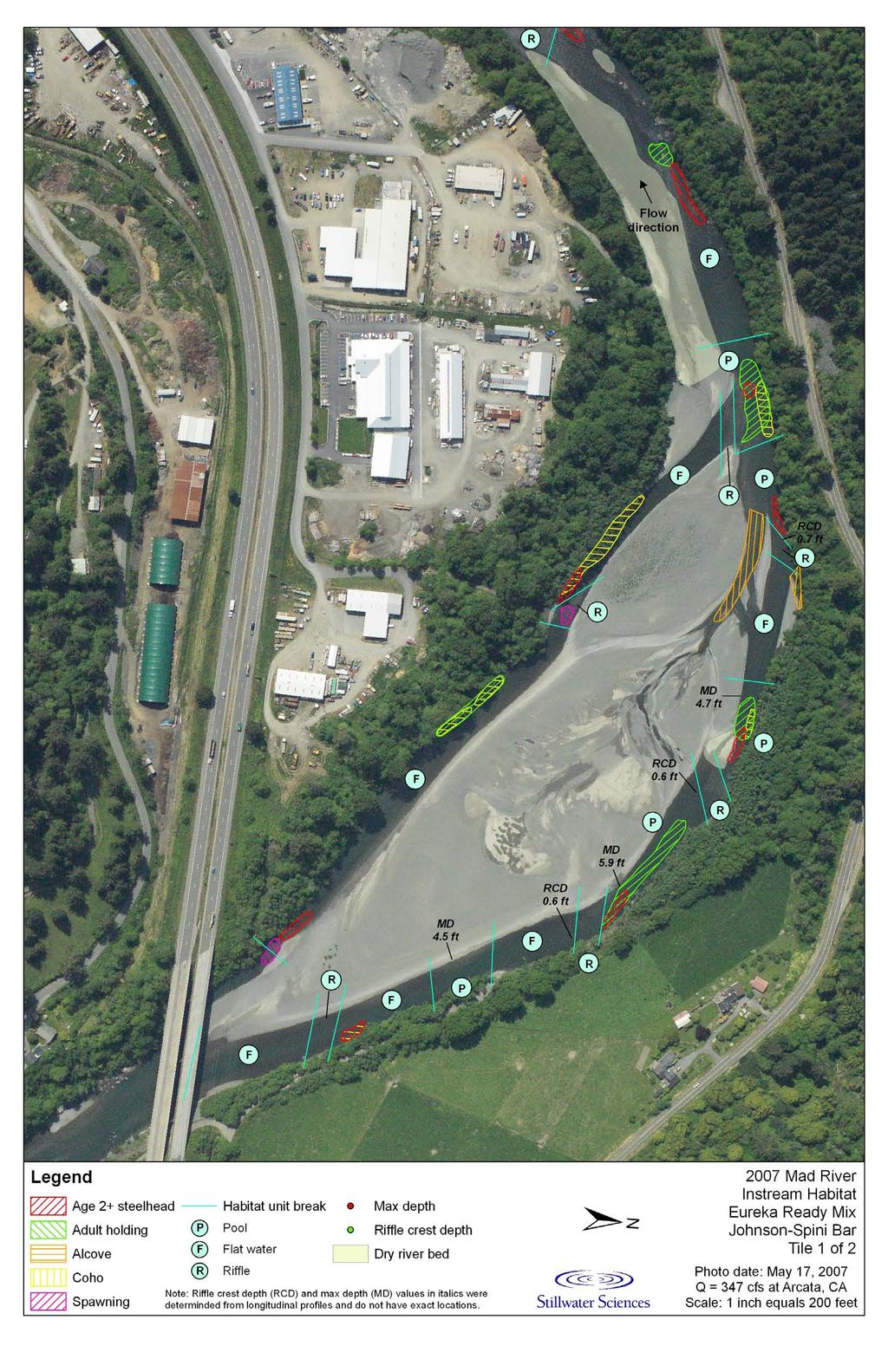
5 2007 Humboldt County Gravel Extraction Fisheries Monitoring Report 2 METHODS The biological monitoring program included collection of habitat data that described the distribution and characteristics of three principal habitat types as described by the California Department of Fish and Game (Flosi et al. 1998): pools, flatwaters, and riffles, with the addition of an alcove habitat. This habitat-typing effort was applied at each site, and extended, at a minimum, one-half of a meander sequence above and below a given extraction site. Habitat types (pools, riffles, flatwaters, and alcoves) were delineated on the current 2007 aerial photograph for the site(s). The maximum depth of pools and riffle crests were also recorded on the aerial photographs or derived from longitudinal profile data collected and/or supervised by licensed land surveyors. A habitat-mapping component was also incorporated into the monitoring program that delineated more specific micro-habitat features based on relevant salmonid life history stages of concern for each reach. Specific micro-habitats included individual locations within the rivers that provided adult salmonid-holding habitat (AH), Age 2+ steelhead-rearing habitat (2+), spawning habitat (SP), juvenile coho-rearing habitat (COHO), and alcoves (AL). Identification of individual micro-habitat locations were based on general habitat suitability criteria for salmonids. The habitat suitability criteria were developed from a literature review (Barnhart 1986, Bjornn and Reiser 1991, and Reeves et al. 1989) with additional calibration by the fisheries biologist that included underwater and streambank observations of fish location, substrate characteristics, and spawning activity, as well as measurements of water depth and velocity. Preferred habitat for adult Chinook salmon consists of a pool with velocity of ft per second (fps) and depth greater than 3 ft. Age 2+ steelhead prefer to reside in run habitats where the water velocity is between 0.75 and 1.5 fps near the bottom, in depth of 1 3 ft, and have a cobble/small boulder substrate. Age 2+ steelhead also prefer head-of-pool habitats below the entry point of riffles. Spawning habitat typically occurs in a pool tailout or riffle where the water is ft deep, flowing at 1 3 fps, over a small gravel to small cobble substrate. Juvenile coho have been observed in the Mad River utilizing the margins of pool and flatwater habitat units with relatively slow ( fps) water velocities that contain overhanging and submerged vegetation. Alcoves are off-channel habitats located on the downstream end of gravel bars, and may provide velocity refuge for juvenile salmonids during high flows and potential thermal refuge during the summer season. The field habitat-mapping component was conducted concurrently with the habitat typing. The mapping required the biologist to identify the individual micro-habitats and delineate their perimeters on aerial photographs. With the exception of the Trinity River, where flows were too high, the biologist would periodically enter the water to conduct underwater observation, as well as measure depths and velocities to ensure accurate delineation of the habitat polygons. Each polygon was given an identification code based on salmonid life history stage use. Depth data were not collected on the Trinity River due to safety concerns. All habitat-mapping units were delineated based on the flow conditions present during data collection. No units were delineated based on the surveyor s projection of what conditions would look like if flows increased or decreased in the future. All habitat types and polygons were digitized into a Geographic Information System (GIS) program. The area (square feet) of the individual habitat polygons and lengths of individual 27 August 2008 Stillwater Sciences 2
6 2007 Humboldt County Gravel Extraction Fisheries Monitoring Report habitat types were determined through the GIS and entered into a Microsoft Excel spreadsheet from which a series of tables was generated for this report. Data analysis included: determining the pool:riffle:flatwater percentages by length of the stream reach; determining residual pool depths; determining the area of the individual habitat polygons; comparing the habitat types and mapped habitat unit areas between years in the Mad River for the years 2002 (Halligan 2003), 2004 (Halligan 2005), (Halligan 2007), and 2007; and comparing the mapped habitat unit areas between years in the lower Eel, South Fork Eel, Van Duzen, and Trinity rivers for (Halligan 2007) and Biological monitoring was conducted in 2007 for the following aggregate extraction companies (Table 2-1): Table 2-1. Companies participating in the biological monitoring program. River Company Gravel Bar Mad River Sand and Gravel (MRS&G) Granite Construction Guynup Emmerson (E) Blue Lake (BL) Mad Johnson (J) Christie Eureka Ready Mix (ERM) Johnson - Spini (J-S) O'Neill Mercer-Fraser (M-F) Essex Eureka Ready Mix Hauck Lower Eel Mercer-Fraser Sandy Prairie Shamrock Materials Drake County of Humboldt Worswick Mercer-Fraser Cooks Valley South Fork Eel Randall Sand and Gravel (RSG) Randall Wallan and Johnson (W&J) Wallan Van Duzen Tom Bess Bess Leland Rock Rock Trinity Mercer-Fraser Willow Creek McKnight 27 August 2008 Stillwater Sciences 3
7 2007 Humboldt County Gravel Extraction Fisheries Monitoring Report 3 RESULTS AND DISCUSSION 3.1 Mad River The 2007 Mad River survey reach totaled 38,839 ft in length, which included the mainstem and secondary channels. The combined pool:riffle:flatwater percentages for the Mad River Sand and Gravel (MRS&G), Granite Construction, Eureka Ready Mix (ERM), and Mercer-Fraser (M-F) reaches were 22:19:60 (Table 3-1). The percentage of the survey reach consisting of pool habitat appeared to decrease between 2006 and 2007 (Table 3-1). However, the 2007 pool length percentage was 69% greater than in 2005 even though the survey s reach length increased by 32%, primarily due to the inclusion of secondary channel habitat data. The amount of riffle habitat was relatively consistent from 2005 through Flatwater percentages appeared to be inversely related to pool percentages (Table 3-1). Table 3-1. Lengths and percentages for Mad River pool:riffle:flatwater habitat units Mad River Hatchery to the lower end of the O Neill Bar. Operator/Bar Pools (ft) Riffles (ft) Flatwaters (ft) MRS&G/Guynup 840 2, ,026 1,804 3,207 2,292 2,802 Granite/E&BL 640 2,970 1,797 2,148 2,253 2,227 6,516 5,758 8,480 ERM/Christie 516 1,984 1, ,173 1,517 4,056 4,030 2,506 Granite/Johnson 624 1, ,628 1,720 2,745 M-F/Essex 687 1,140 1, ,944 1,928 ERM/J-S/O'Neill 575 1,030 2, , ,260 6,297 4,699 Total 3,882 10,537 8,530 5,095 7,316 7,151 20,417 22,041 23,158 P:R:F % Note: There was no requirement to collect pool:riffle:flatwater length data in The increase in survey reach lengths between 2005 (29,394 ft), 2006 (39,894 ft), and 2007 (38,839 ft) were due in large part to the collection of secondary channel habitat data. The 2007 residual depths throughout the survey reach ranged from 1.6 to 9.8 ft and were on average about 0.7 ft shallower than in (Table 3-2). In general, the number of pools within the survey reach increased significantly between 2005 and 2007, which may be due, in part, to the expansion of the survey reach or lack of data in The 2007 adult-holding, spawning, coho, Age 2+ steelhead, and alcove habitat areas within the extraction reaches covered 242,708 ft², 249,256 ft², 72,987 ft², 165,000 ft², and 118,178 ft², respectively (Table 3-3) (See Appendix A for delineated aerial photographs). Between 2004 and 2007, there appeared to be an increase in adult-holding, Age 2+ steelhead, and coho habitat areas (Table 3-3). This increase in habitat may have been due in part to the expansion of the survey reach. Spawning habitat quantity appeared to show a decrease in area. Alcove habitat area showed annual variation. There is an unknown amount of measurement error associated with the habitat-mapping effort. Measurement error could have been introduced into the data from several sources. First, the 2002 data should not be weighed as heavily as the data because the protocol was under 27 August 2008 Stillwater Sciences 4
8 Operator/Bar MRS&G/ Guynup Granite/ Emmerson Granite/ Blue Lake ERM / Christie Granite/ Johnson M-F/ Essex ERM J-S ERM/ O Neill 2007 Humboldt County Gravel Extraction Fisheries Monitoring Report development and the flaws had yet to be resolved. Another source of errors may be caused by the different discharges between the dates when mapping was being conducted and the aerial photographs were flown. For example, discharges for the 2002, 2004, 2005, 2006, and 2007 habitat mapping efforts were cfs, cfs, cfs, cfs, and 352 cfs, respectively. The spring aerial photographs were taken when the river was at a higher discharge ( cfs). This resulted in estimating edges of habitat polygons in relation to morphological features that were submerged on the aerial photographs. Table 3-2. Mad River pool depths for Mad River Hatchery to the O Neill Bar. Maximum Depth (ft) Riffle Crest Depth (ft) Residual Depth (ft) nd <5 ns ns ns ns ns ns ns ns ns ns ns ns ns ns ns ns ns ns ns ns ns ns ns ns ns ns ns ns ns ns ns ns ns ns ns ns Average Depth Notes: ns indicates no survey occurred. - indicates pools were not present even though the entire reach was surveyed. nd indicates no data collected. Depth data for MRS&G (2007), Granite (2005), ERM ( ) taken from longitudinal profiles. Pools do not necessarily occur in the same number or place every year. Therefore, the data can only be used for general comparative purposes and not to compare the depth of an individual pool through the years. 27 August 2008 Stillwater Sciences 5
9 2007 Humboldt County Gravel Extraction Fisheries Monitoring Report Table 3-3. Mad River salmonid habitat areas for Mad River Hatchery to the O Neill Bar. Operator/Bar Adult Holding (ft²) Spawning (ft²) MRS&G/Guynup 16,100 44,867 47,916 74,488 44,403 44, ,722 58,806 58,370 62,102 Granite/E&BL 23,825 57,499 40,511 68,825 28,815 35, , ,434 85,813 32,161 ERM/Christie 24,900 54,450 44,867 31,364 47,338 47, ,938 65,340 68, ,440 Granite/Johnson 14,800 13,504 11,326 19,602 18,024 28,400 26,136 27,878 22,651 19,618 M-F/Essex 26,800 ns 14,375 32,670 20,199 28,600 ns 13,068 10,454 9,167 ERM/ J-S/O'Neill 25,650 43,560 33,106 14,375 83,930 23,000 23,522 21,780 20,038 2,768 Total 132, , , , , , , , , ,256 Operator/Bar Coho (ft²) 2+ Steelhead (ft²) MRS&G/Guynup 0 8,712 5,227 2,316 8,047 3,000 nd 21,780 23,087 39,670 Granite/E&BL 0 5,663 7,406 5,663 6,149 8,500 54,886 48,351 47,916 42,152 ERM/Christie 0 14,375 4,792 3,049 7,939 18,900 28,750 36,591 60,984 29,647 Granite/Johnson 9,325 17,860 19,062 17,860 7,654 4,450 43,560 23,522 9,148 12,099 M-F/Essex 2,800 ns ,900 ns 3,920 14,810 17,777 ERM/ J-S/O'Neill ,503 16,553 43,198 9, ,583 27,443 23,655 Total 12,125 46,610 49,990 45,441 72,987 52, , , , ,000 Operator/Bar Alcove (ft²) MRS&G/Guynup 0 5, ,534 16,391 Granite/E&BL 0 23,087 11,761 35,719 42,369 ERM/Christie 0 61,855 23,958 56,192 0 Granite/Johnson 13,800 19,166 27,443 25,265 21,110 M-F/Essex 0 ns 11,761 5,663 9,328 ERM/ J-S/O'Neill 34,500 5,563 15,246 4,972 28,980 Total 54, ,334 90, , ,178 Note: ns indicates no survey occurred. The 2002 data were collected as a pilot project to develop the habitat-mapping protocol, and as such, those data should not be viewed with as high a degree of confidence as August 2008 Stillwater Sciences 6
10 2007 Humboldt County Gravel Extraction Fisheries Monitoring Report 3.2 Lower Eel River The 2007 lower Eel River survey reach totaled 29,071 ft in length, which included the mainstem and secondary channels. The combined pool:riffle:flatwater percentages for the Eureka Ready Mix (ERM), Mercer-Fraser (M-F), Drake, and Worswick reaches were 16:8:76 (Table 3-4). The percentage of the survey reach consisting of pool habitat appeared to decrease between 2006 and 2007 (Table 3-4). However, the 2007 pool lengths were roughly the same as in The amount of riffle habitat was relatively consistent from 2005 to Flatwater percentages appeared to be inversely related to pool percentages (Table 3-4). Table 3-4. Lower Eel River pool:riffle:flatwater lengths and percentages for mouth of the Van Duzen River to Fernbridge. Operator/Bar Pools (ft) Riffles (ft) Flatwaters (ft) ERM/Hauck 1,180 2, ,008 1,013 1,595 1,365 4,098 M-F/Sandy Prairie 2,195 4,877 4, ,045 1,246 6,380 5,994 6,772 Shamrock/Drake 840 2, ,330 1,375 4,157 Humboldt Co./Worswick ,255 5,565 7,126 Total 4,215 9,494 4,659 1,390 2,438 2,259 19,560 14,299 22,153 P:R:F % Note: There was no requirement to collect pool:riffle:flatwater length data in The 2007 residual depths throughout the survey reach ranged from 4.3 to 11.4 ft and were on average about 0.6 ft shallower than in 2006 (Table 3-5). However, 2007 residual pool depths were deeper than those in 2004 and The number of pools within the survey reach decreased from eight in 2004 to four in Some of this pool loss may be attributed to sediment deposition and channel migration. For example, the loss of the Drake pool could be the result of deposition of bedload carried by the large secondary channel that is present on the west side of Sandy Prairie Island. In addition, one of the Sandy Prairie pools became an alcove when the upstream bar developed, which pushed the thalweg to the west. The 2007 adult-holding, spawning, Age 2+ steelhead, and alcove habitat areas within the extraction reaches covered 473,351 ft², 0 ft², 81,903 ft², and 91,417 ft², respectively (Table 3-6) (See Appendix B for delineated aerial photographs). Between 2005 and 2007, there appeared to be a decrease in adult-holding habitat. The decrease in adult-holding habitat could be attributed to the loss of pools in the Sandy Prairie and Drake reaches. In addition, even though the new Drake flatwater was greater than 3 ft deep, the low-water velocity (<0.5 fps) precluded it from being called adult-holding habitat. The lack of spawning habitat indicated that the lower Eel River is not used by salmonids for spawning. Even if spawning were to occur, the large amount of high flow bedload movement through the reach would result very low to non-existent redd survival. The Age 2+ steelhead habitat area was fairly consistent with what was recorded in 2006 and much greater than what was present in Alcove habitat area showed relative consistency between 2005 and 2006, but was reduced during The loss of alcove habitat area during 2007 was caused by the downstream growth of the Worswick Bar, which pushed the alcove entrance below Fernbridge and outside of the survey reach. No juvenile coho habitat was observed. 27 August 2008 Stillwater Sciences 7
11 2007 Humboldt County Gravel Extraction Fisheries Monitoring Report There may be errors associated with the habitat mapping effort caused by the different discharges between the dates when aerial photographs were flown and when the mapping was conducted. For example, the 2005, 2006, and 2007 aerial photographs were taken when the river discharges at Scotia were 1,640, 1,090, and 1,870 cfs, respectively. Discharges for the 2005, 2006, and 2007 mapping efforts were 204 cfs, 113 cfs, and 74 cfs, respectively. This resulted in estimating edges of habitat polygons in relation to morphological features that were submerged on the aerial photographs. 27 August 2008 Stillwater Sciences 8
12 2007 Humboldt County Gravel Extraction Fisheries Monitoring Report Table 3-5. Lower Eel River pool depths for mouth of the Van Duzen River to Fernbridge. Operator/Bar ERM/Hauck Maximum Depth (ft) Riffle Crest Depth (ft) Residual Pool Depth (ft) M-F/Sandy Prairie Shamrock/Drake Humboldt Co./Worswick Average Depth Notes: - indicates pools were not present even though the entire reach was surveyed. Pools do not necessarily occur in the same number or place every year. Therefore, the data can only be used for general comparative purposes and not to compare the depth of an individual pool through the years. Table 3-6. Lower Eel River mapped habitat unit areas for mouth of the Van Duzen River to Fernbridge. Operator/Bar Adult Holding (ft²) Spawning (ft²) 2+ Steelhead (ft²) Alcove (ft²) ERM/Hauck 65, ,971 39,521 8, ,206 21,787 29, ,107 13,883 M-F/Sandy Prairie 331,762 1,076, , ,448 52,854 44,578 23,292 77,534 Shamrock/Drake 100, , , Humboldt Co./Worswick 15, , ,787 0 Total 512,068 1,580, ,351 8, ,206 94,235 81, , ,186 91, August 2008 Stillwater Sciences 9
13 2007 Humboldt County Gravel Extraction Fisheries Monitoring Report 3.3 South Fork Eel River The 2007 South Fork Eel River survey covered three relatively isolated operations within the Cooks Valley to Redway reach and totaled 18,116 ft in length. The combined pool:riffle:flatwater percentages for the Mercer-Fraser (M-F), Randall Sand and Gravel (RSG), and Wallan and Johnson (W&J) reaches were 22:20:58 (Table 3-7). The pool:riffle:flatwater percentages remained fairly consistent between 2005 and 2007 (Table 3-7); this may have been due in large part to the bedrock-controlled nature of the river channel. Table 3-7. South Forth Eel River pool:riffle:flatwater lengths and percentages for Operator/Bar Pools (ft) Riffles (ft) Flatwaters (ft) M-F/Cooks Valley 1,530 1,717 2,035 1,330 1,158 1,304 3,685 3,567 3,894 Randall/Randall 1, ,028 1,168 1,377 1,550 4,223 4,644 3,815 W&J/Wallan 1, ,150 2,921 2,719 Total 3,880 3,463 4,062 3,253 3,012 3,626 10,058 11,132 10,428 P:R:F % The 2007 residual depths throughout the survey reach ranged from 2.1 to 20.2 ft and were on average about 1.6 ft shallower than in 2006 (Table 3-8). However, 2007 residual pool depths were about a half-foot deeper than those in 2004 and The observed loss of average pool depth between 2006 and 2007 is consistent with what was recorded on the Mad and Lower Eel rivers. The number of pools within the survey reach increased from 12 in 2005 to 16 in The 2007 adult-holding, spawning, Age 2+ steelhead, and alcove habitat areas within the extraction reaches covered 71,420 ft², 45,227 ft², 19,031 ft², and 0, respectively (Table 3-9) (See Appendix C for delineated aerial photographs). Between 2006 and 2007, there appeared to be a decrease in adult-holding habitat, which may be related to the reduction in pool depth. The reduction in the quantity of spawning habitat appeared to be due to coarsening of substrate in pooltails and riffle crests. The reduction in alcove habitat occurred at the Cooks Valley bar, where the usual alcove contained flowing water originating from a tributary and seepage through the gravel bar. This habitat unit also contained temperature-stratified water at the mouth of the tributary. There may be errors associated with the habitat mapping effort caused by the different discharges between the dates when aerial photographs were flown and when the mapping was conducted. For example, the 2005, 2006, and 2007 aerial photographs were taken when the river discharges at Miranda were 122, 207, and 240 cfs, respectively. Discharges for the 2005, 2006, and 2007 mapping efforts were 54 cfs, 29 cfs, and 22 cfs, respectively. This resulted in estimating edges of habitat polygons in relation to morphological features that were submerged on the aerial photographs. 27 August 2008 Stillwater Sciences 10
14 2007 Humboldt County Gravel Extraction Fisheries Monitoring Report Table 3-8. South Fork Eel River pool depths for Operator/Bar Max Depth (ft) Crest Depth (ft) Residual Depth (ft) ns ns ns ns ns ns ns ns ns M-F/Cooks Valley ns ns ns ns ns ns ns ns ns ns ns ns Randall/Randall W&J/Wallan Average Depth Note: ns indicates no survey occurred. - indicates pools were not present even though the entire reach was surveyed. Pools do not necessarily occur in the same number or place every year. Therefore, the data can only be used for general comparative purposes and not to compare the depth of an individual pool through the years. Table 3-9. South Fork Eel River mapped habitat unit areas for Operator/Bar Adult Holding (ft²) Spawning (ft²) 2+ Steelhead (ft²) Alcove (ft²) M-F/Cooks Valley 56,153 55,784 56,747 22,056 54,178 14,187 nd 6,724 5,413 23,322 20,671 0 Randall/Randall 20,982 31,140 8,619 14,880 67,320 18,242 nd 5,301 8,845 2, W&J/Wallan 11,602 16,646 6,053 16,595 13,478 12,799 nd 7,603 4, Total 88, ,570 71,420 53, ,976 45,227 nd 19,628 19,031 26,205 20,671 0 Note: nd indicates no data collected. 27 August 2008 Stillwater Sciences 11
15 2007 Humboldt County Gravel Extraction Fisheries Monitoring Report 3.4 Van Duzen River The 2007 Van Duzen River survey reach totaled 11,442 ft in length and covered the Tom Bess (Carlotta) and Leland Rock (Alton) operations. The combined pool:riffle:flatwater percentages for the two reaches were 18:11:71 (Table 3-10). The pool:riffle:flatwater percentages remained fairly consistent between 2005 and 2006, but the proportion of the survey length made up of pools decreased from 2006 to 2007 (Table 3-10). The decrease in the 2007 pool percentage may have been due to (1) observed sediment intrusion into pools at Tom Bess operation, (2) lack of Noble pool data that typically accounts for about half the pool length in the gravel mining reaches, and (3) channel avulsion at the upstream end of the Leland Rock operation. Table Van Duzen River pool:riffle:flatwater lengths and percentages Operator/Bar Pools (ft) Riffles (ft) Flatwaters (ft) Tom Bess/Bess 1,281 1,296 1, ,449 4,860 4,632 Noble/Noble 2,176 2,567 ns 988 1,426 ns 5,589 4,729 ns Leland Rock/Rock 1,595 1, , ,281 2,471 3,317 Total 5,052 5,212 2,293 3,297 2,949 1,200 11,319 12,060 7,949 P:R:F % Note: ns indicates no survey occurred. Differences in total length between 2006 and 2007 were due mainly to a lack of Noble data (~8,700 ft). The 2007 residual depths throughout the survey reach ranged from 3.5 to 10.0 ft and were on average about 0.7 ft shallower than in 2006 (Table 3-11). The Van Duzen River extraction reaches appear to have experienced a significant decrease in pool depth since Much of the loss in the average residual pool depth stems from the deposition of sediment into the two deepest pools on the Bess property. The number of pools within the Bess and Rock reaches stayed fairly consistent between 2005 and The 2007 adult-holding, spawning, Age 2+ steelhead, and alcove habitat areas within the extraction reaches covered 33,505 ft², 1,817 ft², 11,540 ft², and 5,134 ft², respectively (Table 3-12) (See Appendix D for delineated 2007 aerial photographs). Between 2006 and 2007, there were significant decreases in adult-holding, Age 2+ steelhead, and alcove habitats. The reduction in the quantity of adult-holding areas appeared to be due to sediment deposition into pools, which resulted in shallowing and shortening of these habitat types. In addition, because no monitoring was conducted at the Noble site, significant amounts of adult-holding habitat data were not collected. Similarly, the perceived loss of Age 2+ steelhead habitat may have been due to a lack of Noble monitoring data. The bulk of the alcove loss was caused by the filling in of a single unit on Leland Rock s operation and lack of Noble data collection. There may be errors associated with the habitat mapping effort caused by the different discharges between the dates when aerial photographs were flown and when the mapping was conducted. For example, the 2006 and 2007 aerial photographs were taken when the river discharges at Bridgeville were 570 and 218 cfs, respectively. Discharges for the 2006 and 2007 mapping efforts were 8 cfs, and 7 cfs, respectively. This resulted in estimating edges of habitat polygons in relation to morphological features that were submerged on the aerial photographs. 27 August 2008 Stillwater Sciences 12
16 2007 Humboldt County Gravel Extraction Fisheries Monitoring Report Table Van Duzen River pool depths for Operator/Bar Maximum Depth (ft) Riffle Crest Depth (ft) Residual Pool Depth (ft) Ton Bess/Bess Noble/Noble Leland Rock/Rock Average Depth Note: - indicates pools were not present even though the entire reach was surveyed. Pools do not necessarily occur in the same number or place every year. Therefore, the data can only be used for general comparative purposes and not to compare the depth of an individual pool through the years. Table Lower Van Duzen River mapped habitat unit areas for Operator/Bar Adult Holding (ft²) Spawning (ft²) 2+ Steelhead (ft²) Alcoves (ft²) Tom Bess/Bess 35,062 24, ,817 6,036 5,115 10,749 5,134 Noble 103,228 nd 0 nd 4,961 nd 27,562 nd Leland Rock/Rock 34,507 9, ,691 6,425 46,305 0 Total 172,797 33, ,817 16,688 11,540 84,616 5,134 Note: ns indicates no survey occurred. 27 August 2008 Stillwater Sciences 13
17 2007 Humboldt County Gravel Extraction Fisheries Monitoring Report 3.5 Trinity River The 2007 Trinity River survey reach totaled 9,290 ft in length and covered Mercer-Fraser s Willow Creek and McKnight bars. The combined pool:riffle:flatwater percentages for the two reaches were 55:26:19 (Table 3-13). The pool:riffle:flatwater percentages remained fairly consistent between 2006 and 2007, but the proportion of the survey length made up of pools increased from 2005 to 2006 (Table 3-13). The increase in pool habitat was mirrored by a decrease in flatwaters, while riffles remained stable. Table Trinity River pool:riffle:flatwater lengths and percentages for Operator/Bar Pools (ft) Riffles (ft) Flatwaters (ft) M-F/Willow Creek 1,564 2,618 2, , ,732 M-F/McKnight 1,605 3,324 2,723 2,101 1, ,222 2,114 0 Total 3,169 5,942 5,102 2,756 2,665 2,456 3,662 2,184 1,732 P:R:F % The 2007 adult-holding, spawning, Age 2+ steelhead, and alcove habitat areas within the extraction reaches covered 240,713 ft², 20,673 ft², 80,280 ft², and 0 ft², respectively (Table 3-14) (See Appendix E for delineated 2007 aerial photographs). Between 2005 and 2006, the amount of adult-holding habitat increased by about 40%. Between 2006 and 2007, the amount of holding habitat dropped by about 17%. The amount of spawning habitat in 2007 was about two-and-onehalf times than in 2005, but less than half of what was observed in The main reason for the reduction in spawning habitat between 2006 and 2007 appeared to be substrate coarsening. No Age 2+ steelhead habitat data were collected for the McKnight Bar in 2007 due to surveyor error. No alcove-like features were observed connected to the channel; however, the old trench at Willow Creek, which serves as an alcove, was present. The trench was not mapped as an alcove because it was not a naturally-formed feature. The secondary channel at the McKnight Bar would function as an alcove at higher flows. No pool depths were collected in the Trinity River due to unsafe flow conditions during data collection. Table Trinity River mapped habitat unit areas for Operator/Bar Adult Holding (ft²) Spawning (ft²) 2+ Steelhead (ft²) Alcove (ft²) M-F / Willow Creek 97, ,568 94,776 nd 18,547 14,225 nd 111,629 80,280 15,163 76,608 0 M-F / McKnight 108, , ,937 7,941 26,559 6,448 nd 25,326 nd 2, Total 205, , ,713 7,941 45,106 20, ,955 80,280 17,432 76,608 0 Note: nd indicates no data collected. There may be errors associated with the habitat mapping effort caused by the different discharges between the dates when aerial photographs were flown and the when mapping was conducted. 27 August 2008 Stillwater Sciences 14
18 2007 Humboldt County Gravel Extraction Fisheries Monitoring Report For example, the 2005, 2006, and 2007 aerial photographs were taken when the river discharges at Hoopa were 1,350, 8,570, and 4,830 cfs, respectively. Discharges for the 2005, 2006, and 2007 mapping efforts were 713 cfs, 676 cfs, and 671 cfs, respectively. This resulted in estimating edges of habitat polygons in relation to morphological features that were submerged on the aerial photographs. 27 August 2008 Stillwater Sciences 15
19 2007 Humboldt County Gravel Extraction Fisheries Monitoring Report 4 REFERENCES Barnhart, R. A Species Profiles: Life histories and environmental requirements of coastal fishes and invertebrates (Pacific Southwest) Steelhead. Biological Report 82 (11.60). Prepared by California Cooperative Fishery Research Unit, Humboldt State University, Arcata, California for U.S. Army Corps of Engineers, Coastal Ecology Group, Vicksburg, Mississippi and U.S. Fish and Wildlife Service, National Wetlands Research Center, Washington, D.C. Bjornn, T. C. and D. W. Reiser Habitat requirements of salmonids in streams. American Fisheries Society Special Publication 19: Flosi, G., Downie, S., Hopelain, J., Bird, M., Coey, R., and Collins, B California salmonid stream habitat restoration manual. Third Edition. Inland Fisheries Division, California Department of Fish and Game. Halligan, D. H Final report fisheries monitoring program for gravel extraction operations on the Mad, Eel, Van Duzen, and Trinity Rivers. Natural Resources Management Corporation, Eureka, California. Halligan, D. H Unpublished Mad River instream habitat data. Natural Resources Management Corporation, Eureka, California. Halligan, D. H Final report fisheries monitoring program for gravel extraction operations on the Mad, Eel, Van Duzen, and Trinity Rivers. Natural Resources Management Corporation, Eureka, California. National Marine Fisheries Service (NMFS). 2004a. Batched biological opinion Mad River individual permits Eureka Ready Mix Concrete Company, Inc., Mad River Sand and Gravel, and Granite Construction. Prepared for the U.S. Army Corps of Engineers, San Francisco District. NMFS. 2004b. Biological opinion letter of permission procedure for gravel mining and excavation activities within Humboldt County. Prepared for the U.S. Army Corps of Engineers, San Francisco District. Reeves, G. H., F. H. Everest, and T. E. Nickelson Identification of physical habitats limiting the production of coho salmon in western Oregon and Washington. USDA Forest Service, Pacific Northwest Research Station. General technical report PNW-GTR August 2008 Stillwater Sciences 16
20 Appendix A Delineated Aerial Photographs Mad River

21

22

23

24

25

26

27

28
29

30
31 Appendix B Delineated Aerial Photographs Lower Eel River

32

33

34

35

36
37 Appendix C Delineated Aerial Photographs South Fork Eel River

38

39

40
41 Appendix D Delineated Aerial Photographs Van Duzen River

42

43

44
45 Appendix E Delineated Aerial Photographs Trinity River

46

47
Compensatory Mitigation Monitoring Report Aquatic Habitat Improvement City of Montrose Whitewater Park, Montrose County, Colorado March 6, 2014
 Compensatory Mitigation Monitoring Report Aquatic Habitat Improvement City of Montrose Whitewater Park, Montrose County, Colorado March 6, 2014 i. Project Overview 1. USACE # # SPK 2013 00851 2. Permittee:
ODFW Life Cycle Monitoring Project
 ODFW Life Cycle Monitoring Project Background and Potential as Intensively Monitored Watersheds Erik Suring . Necanicum Lower Nehalem Upper Nehalem Nehalem Scappoose River Scappoose LCM Background Cummins
Technical Memorandum ECO-7
 To: Woody Frossard, TRWD From: Bob Brashear, CDM This document is released for the purpose of interim review under the authority of Robert Brashear, P.E., TX license 80771 on 21-Mar-2005. It is not to
Rebman Creek Evaluation of In-Stream Rehabilitation Structures
 Rebman Creek Evaluation of In-Stream Rehabilitation Structures Draft Report Prepared for: Weldwood of Canada Ltd. Quesnel, BC by: G3 Consulting Ltd. 4508 Beedie Street Burnaby, BC V5J 5L2 December 2000
RE: Engineered Riffle Concepts for Sodom Dam Removal Grade Control Elements
 November 19, 2009 Ms. Melissa Jundt NOAA Fisheries Hydropower Division 1201 NE Lloyd Boulevard, Suite 1100 Portland, Oregon 97232 RE: Engineered Riffle Concepts for Sodom Dam Removal Grade Control Elements
SPECIES PROTECTION CONSTRUCTION Protective Radius
 SPECIES PROTECTION Attention is directed to the existence of environmental work restrictions that require special precautions to be taken by the Contractor to protect the species of concern in conforming
OVERVIEW INTRODUCTION TO SHOREBIRDS MANAGEMENT FOR SHOREBIRDS TVA REGIONAL SHOREBIRD PROJECT ESTIMATING SHOREBIRD NUMBERS
 SHOREBIRD CONSERVATION AND MONITORING RESOURCES US SHOREBIRD CONSERVATOIN PLAN http://www.fws.gov/shorebirdplan WATERFOWL MANAGEMENT HANDBOOK - http://www.nwrc.usgs.gov/wdb/pub/wmh/contents.html MANOMET
R & E Grant Application 13 Biennium
 R & E Grant Application 13 Biennium Project #: 13-080 Project Information R&E Project $4,943.50 Request: Match Funding: $15,750.00 Total Project: $20,693.50 Start Date: 9/1/2014 End Date: 6/30/2015 Project
EVALUATION OF FALL CHINOOK AND CHUM SALMON SPAWNING BELOW BONNEVILLE DAM
 EVALUATION OF FALL CHINOOK AND CHUM SALMON SPAWNING BELOW BONNEVILLE DAM Annual Report 2003-2004 Prepared by Wayne van der Naald Cameron Duff and Robert Brooks Oregon Department of Fish and Wildlife Funded
Harlequin Ducks in Idaho Ecology, Distribution, Monitoring & Conservation
 Paul Higgins Harlequin Ducks in Idaho Ecology, Distribution, Monitoring & Conservation Sonya Knetter & Frances Cassirer, IDFG Jacob Briggs, BYU-Idaho Idaho Bird Conservation Partnership, March 12, 2015
Cat Island Chain Restoration Project Brown County Port & Resource Recovery Department
 Cat Island Chain Restoration Project Brown County Port & Resource Recovery Department February 2, 2015 Fox River and Lower Green Bay Cat Island Chain - 1938 Cat Island Brown County Aerial Photography,
AERIAL SURVEY OF BIRDS AT MONO LAKE ON AUGUST 24, 1973
 AERIAL SURVEY OF BIRDS AT MONO LAKE ON AUGUST 24, 1973 by Ronald M. Jurek Special Wildlife Investigations Wildlife Management Branch California Department of Fish and Game September 1973 Jurek, R.M. 1973.
Bald Eagle Annual Report February 1, 2016
 Bald Eagle Annual Report 2015 February 1, 2016 This page intentionally blank. PROJECT SUMMARY Project Title: Bald Eagle HCP Monitoring Subject Area: Habitat Conservation Plan (HCP) monitoring Date initiated:
LOWER YUBA RIVER ACCORD MONITORING
 LOWER YUBA RIVER ACCORD MONITORING AND EVALUATION PROGRAM AERIAL MAPPING OF STREAMWOOD AND HUMAN- BUILT DETRITUS AVAILABLE AS COVER IN THE LOWER YUBA RIVER IN AUTUMN 2008 MAY 9, 2014 (Aerial photo of a
Fall 2001 Whooping Crane Migrational Survey Protocol Implementation Report
 Fall 2001 Whooping Crane Migrational Survey Protocol Implementation Report Prepared by Executive Director s Office For Committee s of the Platte River Cooperative Agreement June 5, 2002 I. Introduction
Expansion Work Has Begun The perimeter dike for Cell 7 is now visible
 Summer/Fall 2017 In This Issue Poplar Island Expansion Wetland Cell 5AB Development Wildlife Update Birding tours on Poplar Island Expansion Work Has Begun The perimeter dike for Cell 7 is now visible
DRAFT DRAFT DRAFT DRAFT DRAFT. Sonoma County Salmon Coalition June 25, 2008 North Coast Regional Water Quality Control
 DRAFT DRAFT DRAFT DRAFT DRAFT Sonoma County Salmon Coalition June 25, 2008 North Coast Regional Water Quality Control Item 1. Introductions Adina Merenlender, Al Cadd, Al Levine, Al Nelson, Bill Cox, Bob
1. ALTERNATIVE SUITABLE HABITAT HAS NOT BEEN ESTABLISHED
 AMERICAN BIRD CONSERVANCY*DEFENDERS OF WILDLIFE* NATIONAL AUDUBON SOCIETY*OREGON NATURAL RESOURCES COUNCIL*PACIFIC SEABIRD GROUP*SEATTLE AUDUBON SOCIETY* DR. DAVID AINLEY*BRIAN SHARP* DR. GARY SHUGART
Northwest Power & Conservation Council. Acknowledgments. Jessica Adkins, Pete Loschl, Dan Battaglia
 Avian Predation on Juvenile Salmonids in the Lower Columbia River Briefing for the Fish Committee Northwest Power & Conservation Council Oregon State University Real Time Research, Inc. USGS Oregon Cooperative
SPECIAL PUBLIC NOTICE
 SPECIAL PUBLIC NOTICE Draft Map and Drawing Standards for the South Pacific Division Regulatory Program March 5, 2012 Comment period: ends April 5, 2012 Corps contact: Thomas Cavanaugh (415) 503-6574 (Thomas.J.Cavanaugh@usace.army.mil)
Population Estimate and Size Comparison of Orconectes propinquus in Riffle Habitats in Tenderfoot Creek
 Population Estimate and Size Comparison of Orconectes propinquus in Riffle Habitats in Tenderfoot Creek BIOS 35502: Practicum in Field Biology Ashley Baca Advisor: Dr. Todd Crowl 2010 Abstract: Orconectes
Susitna-Watana Hydroelectric Project (FERC No )
") (FERC No. 14241) Fish Distribution and Abundance in the Upper and Middle/Lower Susitna River (Studies 9.5 and 9.6): Draft Chinook and Coho Salmon Identification Protocol Prepared for Prepared by R2 Resource
(FERC No. 14241) Fish Distribution and Abundance in the Upper and Middle/Lower Susitna River (Studies 9.5 and 9.6): Draft Chinook and Coho Salmon Identification Protocol Prepared for Prepared by R2 Resource
Table of Contents. Chapter 1.0 Purpose and Need
 Table of Contents Chapter 1.0 Purpose and Need CHAPTER 1.0 PURPOSE AND NEED... 1 1.1 INTRODUCTION... 1 1.1.1 EA ORGANIZATION... 1 1.2 PROJECT AREA... 1 1.3 PROPOSED ACTION... 2 1.3.1 SCOPE OF THE PROPOSED
SURVEY OF SEAGRASS BEDS AT PLACEMENT AREA 62, WEST BAY CONTRACT FOR GIWW, TEXAS CAUSEWAY U. S. ARMY CORPS OF ENGINEERS CONTRACT NO.
 SURVEY OF SEAGRASS BEDS AT PLACEMENT AREA 62, WEST BAY CONTRACT FOR GIWW, TEXAS CAUSEWAY U. S. ARMY CORPS OF ENGINEERS CONTRACT NO. W912HY-10-C-0036 Prepared for: RLB CONTRACTING, INC. P.O. Box 1739 Port
Chehalis Basin Strategy
 Chehalis Basin Strategy Presented by Marc Hayes, Julie Tyson, and Keith Douville September 22, 2015 1 photo courtesy of The Chronicle, Centralia, Washington Survey Methods Visual encounter; 3-5 surveyors;
SPECIAL PUBLIC NOTICE
 SPECIAL PUBLIC NOTICE Draft Map and Drawing Standards for the South Pacific Division Regulatory Program August 6, 2012 Corps contacts: Sacramento District: Michael Finan (916) 557-5324 (Michael.C.Finan@usace.army.mil)
Golden Eagle (Aquila chrysaetos) Management Indicator Species Assessment Ochoco National Forest
 Management Indicator Species Assessment Ochoco National Forest") Golden Eagle (Aquila chrysaetos) Management Indicator Species Assessment Ochoco National Forest I. Introduction The golden eagle was chosen as a terrestrial management indicator species (MIS) on the Ochoco
Golden Eagle (Aquila chrysaetos) Management Indicator Species Assessment Ochoco National Forest I. Introduction The golden eagle was chosen as a terrestrial management indicator species (MIS) on the Ochoco
Board Meeting. Stewardship Departmental Update. Authorization for Biological Services Contracts. February 6, 2018
 Board Meeting February 6, 2018 Authorization for Biological Services Contracts Stewardship Departmental Update Matt Graul, Chief of Stewardship EBRPD Board Meeting February 6, 2018 OVERVIEW Scope of Proposed
Feasibility Study To Define Costs & General Conditions For Construction of Improved Entrance Structure
 Feasibility Study To Define Costs & General Conditions For Construction of Improved Entrance Structure From Lake Michigan Into Mona Lake Muskegon County, Michigan Muskegon Chronicle, August 2007 Prepared
Cattle-Free for 10 Years!
 Cattle-Free for 10 Years! Big Whitney Meadow after a Decade of Rest From Cattle Impact Photographs and text produced by Todd Shuman, August, 2011. For more information, email Todd at tshublu@yahoo.com
Species Conclusions Table
 Species Conclusions Table Project Manager: Theresita Crockett-Augustine Date: May 9, 2016 Project Name: Huntington Run Levee Project Number: NAO-2014-00272 Consultation Code: 05E2VA00-2016-SLI-1964 Event
Roberts Bank Terminal 2 Project Field Studies Information Sheet
 July 2012 Port Metro Vancouver is continuing field studies in July as part of ongoing environmental and technical work for the proposed Roberts Bank Terminal 2 Project. Roberts Bank Terminal 2 Project
BV-24A DMMA Florida Scrub-Jay Survey Brevard County
 REPORT BV-24A DMMA Florida Scrub-Jay Survey Brevard County Submitted to: David L. Stites, Ph.D. Director of Environmental Services Taylor Engineering, Inc. 10199 Southside Blvd Suite 310 Jacksonville,
THREATENED, ENDANGERED, AND SENSITIVE SPECIES 2011 ANNUAL REPORT
 LICENSE ARTICLE 410 THREATENED, ENDANGERED, AND SENSITIVE SPECIES 2011 ANNUAL REPORT REPORTING PERIOD JANUARY 1 DECEMBER 31, 2011 BAKER RIVER HYDROELECTRIC PROJECT FERC. 2150 April 2012 BAK LA 410 Annual
Roberts Bank Terminal 2 Project Field Studies Information Sheet
 January 2013 Port Metro Vancouver is continuing field studies in January as part of ongoing environmental and technical work for the proposed. The is a proposed new multi berth container terminal which
US Army Corps of Engineers Rock Island District
 US Army Corps of Engineers Rock Island District Compiled by Marsha Dolan March 2014 The American Bald Eagle: Natural History & Current Conditions The bald eagle has proudly served as the emblem for the
Division: Habitat and Species Conservation Authors: Claire Sunquist Blunden and Brad Gruver
 Division: Habitat and Species Conservation Authors: Claire Sunquist Blunden and Brad Gruver Report date: December 13, 2018 All photos by FWC unless otherwise acknowledged Presenting 6 new guidelines 1
Status and Movements of the North Pacific Humpback Whale Population
 Status and Movements of the North Pacific Humpback Whale Population 1 Some Basics Feed in high latitude, cool waters (Summer) Breed and calve in low latitude, warm waters (Winter) Migration is over 2500
Bald Eagle and Osprey Nest Survey Study Plan for Energy Northwest's Packwood Lake Hydroelectric Project FERC No Lewis County, Washington
 Revised Bald Eagle and Osprey Nest Survey Study Plan for Energy Northwest's Packwood Lake Hydroelectric Project FERC No. 2244 Lewis County, Washington Submitted to P.O. Box 968 Richland, Washington 99352-0968
Pintail Duck. Anas acuta
 Pintail Duck Anas acuta Breeding range extends from Alaska south to Colorado and east through the upper Midwest, Great Lakes, and eastern Canada. In winter, migrates to California, southern United States,
Collaboration and Planning to Implement the South San Diego Bay Restoration and Enhancement Project
 Collaboration and Planning to Implement the South San Diego Bay Restoration and Enhancement Project Carolyn Lieberman Coastal Program Coordinator for Southern California U.S. Fish and Wildlife Service
Eddy Gulch Late-Successional Reserve Northern Spotted Owl, Northern Goshawk and Landbird Survey Report 2008
 Eddy Gulch Late-Successional Reserve Northern Spotted Owl, Northern Goshawk and Landbird Survey Report 2008 Submitted to Sam Cuenca District Wildlife Biologist Scott Salmon River Ranger District, Klamath
Analysis of Reference Tidal Channel Plan Form For the Montezuma Wetlands Restoration Project
 Analysis of Reference Tidal Channel Plan Form For the Montezuma Wetlands Restoration Project Sarah Pearce, Geomorphologist Joshua N. Collins, Project Manager Contribution No. 80 May, 2004 ACKNOWLEDGEMENTS
NAPA MARSHES RESTORATION Coastal Ecosystem Restoration Through Collaborative Partnerships
 NAPA MARSHES RESTORATION Coastal Ecosystem Restoration Through Collaborative Partnerships National Conference on Ecosystem Restoration July 29-August 2, 2013 Jeff McCreary Director of Conservation Programs
A.11 BALD EAGLE (HALIAEETUS. Species Distribution and Status
 A.11 BALD EAGLE (HALIAEETUS LEUCOCEPHALUS) A.11.1 Legal Status The bald eagle was listed as endangered under the federal Endangered Species Act (ESA) in 1978 (43 FR 6230). In 1995, the bald eagle was reclassified
A Rising Tide: Conserving Shorebirds and Shorebird Habitat within the Columbia River Estuary
 A Rising Tide: Conserving Shorebirds and Shorebird Habitat within the Columbia River Estuary By Vanessa Loverti USFWS Migratory Birds and Habitat Programs, Portland, Oregon May 28, 2014 Outline of Talk
In response to a request from Water Rights Branch, a short. In general, the sequence of post glacial events in the immediate. D. M.
 . TO Dr. J. C. Foweraker......!...... C&* Groundwater Div i s ion... GOVERNMENT OF BRITISH COLUMBIA M EM0 RAN DU M D. M. Callan Groundwater Division... July 6th... 19... 71... SUBJECT GROUNDWATER INVESTIGATION
Tahkenitch Creek Estuary BCS number: 47-35
 Tahkenitch Creek Estuary BCS number: 47-35 ***NOTE: We were unable to determine all necessary information for this site description. If you would like to contribute the needed information to this description,
NOAA Fisheries, Northwest Fisheries Science Center, 2725 Montlake Blvd. E.,Seattle, WA
 Genetic Analysis of Caspian Tern (Hydroprogne caspia) and Double Crested Cormorant (Phalacrocorax auritus) Salmonid depredation in the Columbia River Estuary 2006-2013 David Kuligowski 1, Laurie Weitkamp
Red-breasted Merganser Minnesota Conservation Summary
 Credit Jim Williams Red-breasted Merganser Minnesota Conservation Summary Audubon Minnesota Spring 2014 The Blueprint for Minnesota Bird Conservation is a project of Audubon Minnesota written by Lee A.
Bald Eagle Wintering Activity Rocky Reach Reservoir
 Bald Eagle Wintering Activity Rocky Reach Reservoir 2011-2012 Public Utility District No. 1 of Chelan County Fish & Wildlife Department Wenatchee, WA 98807-1231 INTRODUCTION The Public Utility District
Smith River Mouth BCS number: 86-6
 Smith River Mouth BCS number: 86-6 ***NOTE: We were unable to determine all necessary information for this site description. If you would like to contribute the needed information to this description,
Peregrine Falcon Falco peregrinus
 Plant Composition and Density Mosaic Distance to Water Prey Populations Cliff Properties Minimum Patch Size Recommended Patch Size Home Range Photo by Christy Klinger Habitat Use Profile Habitats Used
Black-crowned Night-heron Minnesota Conservation Summary
 Credit Deborah Reynolds Black-crowned Night-heron Minnesota Conservation Summary Audubon Minnesota Spring 2014 The Blueprint for Minnesota Bird Conservation is a project of Audubon Minnesota written by
Pacific Salmon and the Species at Risk Act
 Pacific Salmon and the Species at Risk Act An overview of the listing process & timelines for Pacific Salmon Presentation by Karen Leslie to the Forum on Conservation and Harvest Planning for Fraser Salmon
Columbia River Estuary Conference Astoria 2010
 Columbia River Estuary Conference Astoria 2010 Implementation and Adaptation of the Caspian Tern Management Plan for the Columbia River Estuary: Will it Reduce Mortality of Juvenile Salmonids in the Estuary?
RECENT CHANGES TO THE ILLINOIS SMCRA THREATENED AND ENDANGERED SPECIES (T&E) REQUIREMENTS
 REQUIREMENTS") RECENT CHANGES TO THE ILLINOIS SMCRA THREATENED AND ENDANGERED SPECIES (T&E) REQUIREMENTS William O Leary, M.S. and Amanda Pankau, M.S. HDR Engineering Murphysboro, IL ILLINOIS SMCRA T&E HISTORY 1983 2009
RECENT CHANGES TO THE ILLINOIS SMCRA THREATENED AND ENDANGERED SPECIES (T&E) REQUIREMENTS William O Leary, M.S. and Amanda Pankau, M.S. HDR Engineering Murphysboro, IL ILLINOIS SMCRA T&E HISTORY 1983 2009
Baskett Slough National Wildlife Refuge BCS number: 47-4
 Baskett Slough National Wildlife Refuge BCS number: 47-4 Site description author(s) Daphne E. Swope, Research and Monitoring Team, Klamath Bird Observatory Primary contact for this site N/A Location (UTM)
Roberts Bank Terminal 2 Project Field Studies Information Sheet
 May 2013 Port Metro Vancouver is continuing field studies in May as part of ongoing environmental and technical work for the proposed Roberts Bank Terminal 2 Project. Roberts Bank Terminal 2 Project The
Performance Monitoring
 Performance Monitoring Rock Island District Kara N. Mitvalsky, P.E. CEMVR-EC-DN Traditional Reports Analysis of existing data Comparison of data points to objectives identified in the feasibility reports
US Army Corps of Engineers Rock Island District
 US Army Corps of Engineers Rock Island District Compiled by Davi Michl March 218 The American Bald Eagle: 2 Natural History & Current Conditions The bald eagle has proudly served as the emblem for the
San Juan River Watershed: Fish Passage Assessments
 San Juan River Watershed: Fish Passage Assessments Table of Contents 1.0 INTRODUCTION...6 1.1 BACKGROUND... 6 1.2 STUDY AREA... 7 1.3 SCOPE... 7 1.4 ASSUMPTIONS... 7 1.5 LIMITATIONS... 8 1.6 PROJECT SCHEDULE...
Habitat changes force waterfowl to flee the coast by large amount
 Habitat changes force waterfowl to flee the coast by large amount BY: SHANNON TOMPKINS HOUSTON CHRONICLE MARCH 2, 2016 Photo: Picasa While the Texas coast still winters the majority of the continent's
Wood Stork Aerial Survey Trip Report. Lake Murray and Saluda River August 27, Aircraft: Fixed-Wing Cessna 210 Survey Duration: hrs
 Survey Attendees Shane Boring Tom Murphy Bucky Harris Kleinschmidt SCDNR Endangered Species Biologist SCDNR Pilot Aircraft: Fixed-Wing Cessna 210 Survey Duration: 1300 1415 hrs Survey Observations The
HOW THE OTHER HALF LIVES: MONARCH POPULATION TRENDS WEST OF THE GREAT DIVIDE SHAWNA STEVENS AND DENNIS FREY. Biological Sciences Department
 HOW THE OTHER HALF LIVES: MONARCH POPULATION TRENDS WEST OF THE GREAT DIVIDE SHAWNA STEVENS AND DENNIS FREY Biological Sciences Department California Polytechnic State University San Luis Obispo, California
Plover: a Subpopulation-Based Model of the Effects of Management on Western Snowy Plovers
 Plover: a Subpopulation-Based Model of the Effects of Management on Western Snowy Plovers Michele M. Tobias University of California, Davis, One Shields Avenue, Davis, CA 95616 mmtobias@ucdavis.edu Abstract.
Relicensing Study 3.5.1
 Relicensing Study 3.5.1 BASELINE INVENTORY OF WETLAND, RIPARIAN AND LITTORAL HABITAT IN THE TURNERS FALLS IMPOUNDMENT, AND ASSESSMENT OF OPERATIONAL IMPACTS ON SPECIAL-STATUS SPECIES Updated Study Report
Sea Duck Joint Venture Annual Project Summary for Endorsed Projects FY08 (October 1, 2007 to September 30, 2008)
") Sea Duck Joint Venture Annual Project Summary for Endorsed Projects FY08 (October 1, 2007 to September 30, 2008) Project Title: SDJV#16, Ducks Unlimited Canada s Common Eider Initiative (year five of a
Sea Duck Joint Venture Annual Project Summary for Endorsed Projects FY08 (October 1, 2007 to September 30, 2008) Project Title: SDJV#16, Ducks Unlimited Canada s Common Eider Initiative (year five of a
Smith and Bybee Wetlands Natural Area BCS number 47-33
 Smith and Bybee Wetlands Natural Area BCS number 47-33 Site description author(s) Elaine Stewart, Smith and Bybee Lakes Wildlife Area Manager Danielle Morris, Research and Monitoring Team, Klamath Bird
Humboldt Bay NWR BCS number: 86-4
 Humboldt Bay NWR BCS number: 86-4 ***NOTE: We were unable to determine all necessary information for this site description. If you would like to contribute the needed information to this description, please
Genetic Analysis for Spring- and Fall- Run San Joaquin River Chinook Salmon for the San Joaquin River Restoration Program
 Study 49 Genetic Analysis for Spring- and Fall- Run San Joaquin River Chinook Salmon for the San Joaquin River Restoration Program Final 2015 Monitoring and Analysis Plan January 2015 Statement of Work
Tiered Species Habitats (Terrestrial and Aquatic)
") Tiered Species Habitats (Terrestrial and Aquatic) Dataset Description Free-Bridge Area Map The Department of Game and Inland Fisheries (DGIF s) Tiered Species Habitat data shows the number of Tier 1, 2
Tiered Species Habitats (Terrestrial and Aquatic) Dataset Description Free-Bridge Area Map The Department of Game and Inland Fisheries (DGIF s) Tiered Species Habitat data shows the number of Tier 1, 2
Marbled Murrelet Effectiveness Monitoring, Northwest Forest Plan
 Marbled Murrelet Effectiveness Monitoring, Northwest Forest Plan 2014 Summary Report Northwest Forest Plan Interagency Regional Monitoring Program Photo credits: M. Lance, WDFW (top), M.G. Shepard (bottom)
The Western Section of The Wildlife Society and Wildlife Research Institute Western Raptor Symposium February 8-9, 2011 Riverside, California
 The Western Section of The Wildlife Society and Wildlife Research Institute Western Raptor Symposium February 8-9, 2011 Riverside, California Symposium Sponsors February 9 09:55-10:15 am Session: Raptor
Pilot Project Ross Valley Watershed Geomorphology GIS Database Final Report August 30, 2010
 Pilot Project Ross Valley Watershed Geomorphology GIS Database Final Report August 30, 2010 Prepared by: Gerhard Epke 2010 Watershed Intern (831) 332-1324 24 Bolinas Ave San Anselmo, CA 94960 Supervised
Memorandum. Application for Amendment to DNR Land Use Permit # LAS29209
 Memorandum Date: September 12, 2013 Project Number: 1992.06k To: From: Subject: cc: Jessica Meybin (ADNR) Tim Sullivan (R2) Application for Amendment to DNR Land Use Permit # LAS29209 Kevin Petrone and
Marine Corps Support Facility-Blount Island: Integrated Natural Resources Program Successes. E2S2 Conference May 12, 2011
 Marine Corps Support Facility-Blount Island: Integrated Natural Resources Program Successes E2S2 Conference May 12, 2011 Shari Kennedy, MCSF-BI Robert Price, CH2M HILL Location Mission The mission of Marine
REPORT TO COUNCIL DORWICK DITCH PETITION REHABILITATION PROJECT JUNE 8, 2016
 REPORT TO COUNCIL DORWICK DITCH PETITION REHABILITATION PROJECT JUNE 8, 2016 Based on a preliminary study by Euthenics, Inc. www.euthenics_inc.com 1 SECTION I GENERAL INFORMATION AND EXISTING CONDITIONS
APC REGULATORY UPDATE NOVEMBER 16, PennDOT AND
 APC REGULATORY UPDATE PennDOT AND NOVEMBER 16, 2017 WELCOME TO THE APC Regulatory Overview Threatened and Endangered Bats & Bridges PA DEP Functional Assessments & NPDES Waters of the United States Mitigation
BALD EAGLE MANAGEMENT 2014 ANNUAL REPORT
 SETTLEMENT AGREEMENT ARTICLE 513 BALD EAGLE MANAGEMENT 2014 ANNUAL REPORT REPORTING PERIOD JANUARY 1 DECEMBER 31, 2014 BAKER RIVER HYDROELECTRIC PROJECT FERC No. 2150 September 2015 PUGET SOUND ENERGY
American White Pelican Minnesota Conservation Summary
 Credit Carrol Henderson American White Pelican Minnesota Conservation Summary Audubon Minnesota Spring 2014 The Blueprint for Minnesota Bird Conservation is a project of Audubon Minnesota written by Lee
CLASSIFICATION OF HISTORIC LAKES AND WETLANDS
 CLASSIFICATION OF HISTORIC LAKES AND WETLANDS Golden Valley, Minnesota Image Analysis Heather Hegi & Kerry Ritterbusch 12/13/2010 Bassett Creek and Theodore Wirth Golf Course, 1947 FR 5262 Remote Sensing
KKR S. 6 th St. to I-94 Bridge Project Location. Expanded Floodplains
 Kinnickinnic River Watercourse Rehabilitation Early Out Project Achieving Multiple Design Objectives Thomas R. Sear, PE, CFM Short Elliott Hendrickson Patrick C. Elliott, PE Milwaukee Metropolitan Sewerage
REVISED DRAFT - 8/21/00 BIOLOGICAL OPINION ON THE OPERATION OF THE MISSOURI RIVER MAIN STEM RESERVOIR SYSTEM,
 REVISED DRAFT - 8/21/00 BIOLOGICAL OPINION ON THE OPERATION OF THE MISSOURI RIVER MAIN STEM RESERVOIR SYSTEM, OPERATION AND MAINTENANCE OF THE MISSOURI RIVER BANK STABILIZATION AND NAVIGATION PROJECT,
Upper Klamath National Wildlife Refuge Complex Upper Klamath Unit and Hank s Marsh Unit BCS Number: 48-29
 Oregon Coordinated Aquatic Bird Monitoring: Description of Important Aquatic Bird Site Upper Klamath National Wildlife Refuge Complex Upper Klamath Unit and Hank s Marsh Unit BCS Number: 48-29 Site description
Prepared for: EL DORADO IRRIGATION DISTRICT 2890 MOSQUITO ROAD PLACERVILLE, CALIFORNIA Prepared by:
 RESULTS OF 2005 SURVEYS FOR FOOTHILL YELLOW-LEGGED FROG (Rana boylii) ON THE SOUTH FORK AMERICAN RIVER, EL DORADO COUNTY, CALIFORNIA FOR THE EL DORADO HYDROELECTRIC PROJECT (FERC NO. 184) Prepared for:
Trinity River Bird and Vegetation Monitoring: 2015 Report Card
 Trinity River Bird and Vegetation Monitoring: 2015 Report Card Ian Ausprey 2016 KBO 2016 Frank Lospalluto 2016 Frank Lospalluto 2016 Background The Trinity River Restoration Program (TRRP) was formed in
ARTICLE 3: WATERSHED MANAGEMENT PERMIT REQUIREMENTS AND SUBMITTALS
 ARTICLE 3: WATERSHED MANAGEMENT PERMIT REQUIREMENTS AND SUBMITTALS Introduction This section provides guidance on the submittal requirements for a development to obtain a Watershed Management Permit from
Tualatin River NWR and Wapato Lake BCS number: 47-37
 Tualatin River NWR and Wapato Lake BCS number: 47-37 ***NOTE: We were unable to determine all necessary information for this site description. If you would like to contribute the needed information to
TOPICS TO BE COVERED. 1) Planning Areas 2) Scoping 3) Public Meetings 4) DRAFT Release 5) Secondary Scoping 6) Final Designation
 Planning Areas 2) Scoping 3) Public Meetings 4) DRAFT Release 5) Secondary Scoping 6) Final Designation") TOPICS TO BE COVERED L.D. 1465 (P.L. 270) Where it came from, how it worked, and what it did. The Department of Conservation (DOC) and State Planning Office (SPO) Process: 1) Planning Areas 2) Scoping
TOPICS TO BE COVERED L.D. 1465 (P.L. 270) Where it came from, how it worked, and what it did. The Department of Conservation (DOC) and State Planning Office (SPO) Process: 1) Planning Areas 2) Scoping
alba) ) on the Susquehanna River in Harrisburg, Pennsylvania in Relation to Environmental Characteristics
 ) on the Susquehanna River in Harrisburg, Pennsylvania in Relation to Environmental Characteristics") Foraging Behavior of Great Egrets (Ardea( alba) ) on the Susquehanna River in Harrisburg, Pennsylvania in Relation to Environmental Characteristics W. Brad Romano, Don L. Detwiler, Dr.Terry L. Master,
Foraging Behavior of Great Egrets (Ardea( alba) ) on the Susquehanna River in Harrisburg, Pennsylvania in Relation to Environmental Characteristics W. Brad Romano, Don L. Detwiler, Dr.Terry L. Master,
TABLE OF CONTENTS. Executive Summary 1 Acknowledgements 3 Introduction 3 Storm Recovery and Beach Project Effectiveness 3
 TABLE OF CONTENTS Executive Summary 1 Acknowledgements 3 Introduction 3 Storm Recovery and Beach Project Effectiveness 3 Monmouth County 4 Figures 1a-1d. Monmouth County Station Locations 5 Site Descriptions
4-H Conservation Guidelines
 4-H Conservation Guidelines The following are guidelines for providing learning experiences in the conservation project area. THE GUIDELINES FOR ALL MEMBERS Understand what Natural Resources are; how to
Whakapapa River: 2014 Drift Dive Survey. Author: Adam Daniel Publication date: June 6, 2014 Auckland/Waikato Fish and Game Hamilton New Zealand
 Whakapapa River: 2014 Drift Dive Survey Author: Adam Daniel Publication date: June 6, 2014 Auckland/Waikato Fish and Game Hamilton New Zealand 1 SUMMARY Two drift dive surveys were carried out in the headwaters
Site Improvement Plan. Upper Nene Valley Gravel Pits SPA. Improvement Programme for England's Natura 2000 Sites (IPENS) Planning for the Future
 Planning for the Future") Improvement Programme for England's Natura 2000 Sites (IPENS) Planning for the Future Site Improvement Plan Upper Nene Valley Gravel Pits Site Improvement Plans (SIPs) have been developed for each Natura
Improvement Programme for England's Natura 2000 Sites (IPENS) Planning for the Future Site Improvement Plan Upper Nene Valley Gravel Pits Site Improvement Plans (SIPs) have been developed for each Natura
Sandhill Cranes and Waterfowl of the North Platte River Valley: Evaluation of Habitat Selection to Guide Conservation Delivery
 Sandhill Cranes and Waterfowl of the North Platte River Valley: Evaluation of Habitat Selection to Guide Conservation Delivery { Emily Munter, Wildlife Biologist U.S. Fish and Wildlife Service Nebraska
MAPPING YOUR STREAM. TIME REQUIRED 50 minutes in Field 50 minutes in Classroom 50 minutes Homework
 OUR MAPPING YOUR STREAM STREAM ACTIVITY SUMMARY Students will draft a cross-sectional profile of the stream and measure the velocity of the current. They will use both of these to calculate the discharge
UNDERWATER NOISE, MARINE SPECIES PROTECTION, AND IMPLICATIONS FOR MARINE SURVEYS. Presenter: Denise Toombs Company: ERM
 UNDERWATER NOISE, MARINE SPECIES PROTECTION, AND IMPLICATIONS FOR MARINE SURVEYS Presenter: Denise Toombs Company: ERM Presenter Profile Ms. Denise Toombs is a Partner at ERM with over 25 years of experience
Mystic Lake Hydroelectric Project FERC Project Number Year Bald Eagle Monitoring Summary Report Public
 Mystic Hydroelectric Project FERC Project Number 2301 3-Year Bald Eagle Monitoring Summary Report 2010-2013 Public 2013 by PPL Montana, LLC. ALL RIGHTS RESERVED Submitted to: Federal Energy Regulatory
Economic values of protected marine species in the U.S.: Empirical studies and conceptual challenges for ecosystem-based management *
 Economic values of protected marine species in the U.S.: Empirical studies and conceptual challenges for ecosystem-based management * Daniel K. Lew Alaska Fisheries Science Center National Marine Fisheries