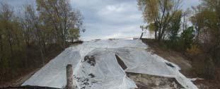
KKR S. 6 th St. to I-94 Bridge Project Location. Expanded Floodplains
|
|
|
- Amberlynn Sara Goodwin
- 5 years ago
- Views:
Transcription

")
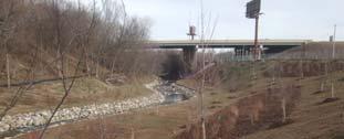
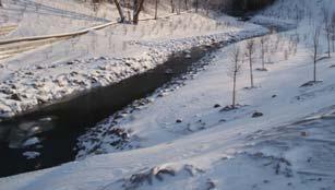
1 Kinnickinnic River Watercourse Rehabilitation Early Out Project Achieving Multiple Design Objectives Thomas R. Sear, PE, CFM Short Elliott Hendrickson Patrick C. Elliott, PE Milwaukee Metropolitan Sewerage District Kinnickinnic River (KKR) Watershed KKR S. 6 th St. to I-94 Bridge Project Location Expanded Floodplains 1


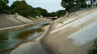


2 Kinnickinnic River, Improved Channel Updated Floodplain (SEWRPC, 2008) 6 th St Bridge 2


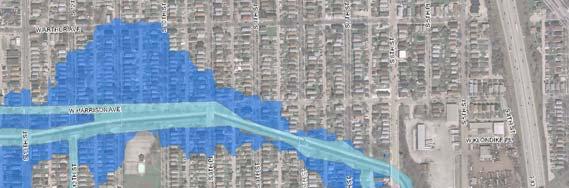
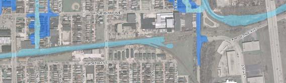
3 KKR Stakeholder Meetings KKR Technical Stakeholder Group for KKR M i t W k 6th 27th Mainstem Work: Neighborhood Plan for 6th 16th Street Included: City, County, WDNR, SEWRPC, Neighborhood & Business Groups, 16th Street Community Health Center, Local NGOs KKR 6th I94 Bridge: Early Out Projects Response to 2008 Flood Event South 6th Street South h 5th Street Bridge KKR FM Project Limits Downstream WC Segment Kinnickinnic River 3


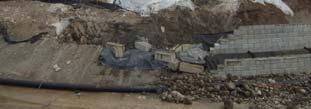
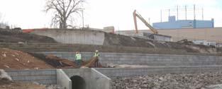
4 KKR FM Project Limits Bridge South 5th Street Downstream WC Segment eet South 6 th Stre Kinnickinnic River KKR FM S. 6 th St. to I-94 Bridge Project Area Characteristics South 6 th Street Bridge Upstream Watercourse Segment 500 feet of concrete lined channel Confined cross-sections Steep northern embankment MMSD CSO Facility on south Downstream Watercourse Segment 500 feet of earthen / rock lined channel Eroded north embankment, south of 5 th Street South embankment instability 4
) Downstream")


5 KKR S. 6 th Street Bridge Prior to Replacement Upstream (West Side)) Downstream (East Side)) Proposed Improvements KKR S. 6 th Street Bridge Design Objectives Significantly reduce upstream WSE s Maintenance / bike path beneath bridge Proposed Design Features Clear span concrete girder bridge Functional, durable and attractive bridge Implementation Final Design Completed December 2009 Construction Completed December 2010 $2.5 Million ARRA Grant 5

) KKR")


6 KKR S. 6th St. Bridge December 2010 Upstream (West Side)) KKR Upstream Watercourse Segment Steep Embankment with Grouted Backfill End of Concrete Lined Channel Combined Sewer Outfall MMSD KK1 Facility Maintenance Ramp South 6th Street 6


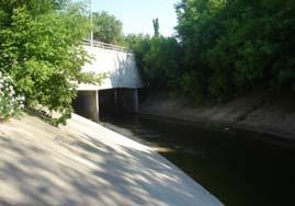
7 KKR Downstream of South 6 th Street Bridge June 7, 1961 KKR Upstream Watercourse Segment 7


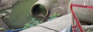
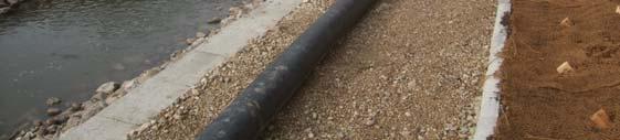
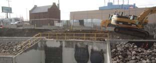
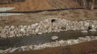
8 KKR Downstream Watercourse Segment End of Concrete Lined Channel Eroded Side Slope due to 5th Street Runoff Failing Revetment Wall KKR Earthen / Rock Lined Channel Storm Sewer Outfalls Storm Sewer Outfall Exposed Abandoned Flushing Pipeline Steep and Unstable Side Slopes Sl KKR Downstream Watercourse Segment 8

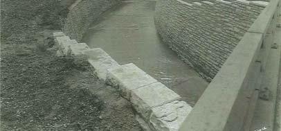
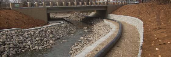
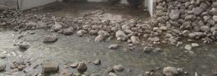
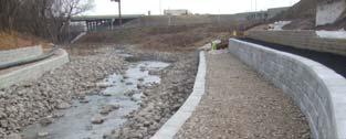
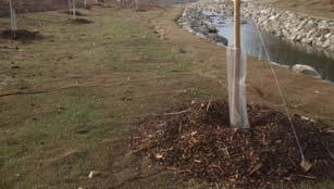
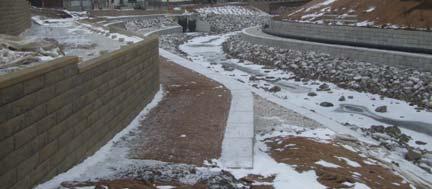
9 KKR Watercourse Improvements Design Objectives Stone lined channel with riffles and pools Maintain stable side slopes / hydraulic capacity Native vegetation plantings Upstream Watercourse Tiered retaining walls 15 ft. wide maintenance / bike path Downstream Watercourse 2:1 to 4:1 native vegetated side slopes Reuse of limestone blocks Upstream KKR Improvements Retaining Walls Minimum 2:1 Side Slope Side Slope Future KKR Bike Trail 9


10 Upstream KKR Cross-Sections Downstream KKR Improvements Repair erosion from 5 th St. runoff Five Pools within Main Channel Future KKR Bike Path 4:1 Side Slope, where space allows 10


11 KKR Downstream Cross-Section Typical Riffle Section KKR Main Channel Cross-Sections Typical Pool Section 11
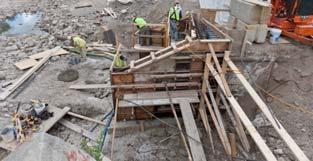
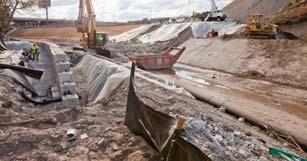

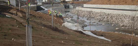
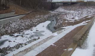
12 2011 Watercourse Construction KKR S. 6 th St. Bridge and Watercourse December 2011 Pre-Improvement 12


13 KKR Watercourse - Upstream Segment December 2011 Pre-Improvement KKR Watercourse - Transition Segment December 2011 Pre-Improvement 13


14 KKR Watercourse - Transition Segment December 2011 Pre-Improvement KKR Watercourse - Downstream Segment December 2011 Pre-Improvement 14


15 KKR Watercourse - December 2011 KKR Watercourse - December


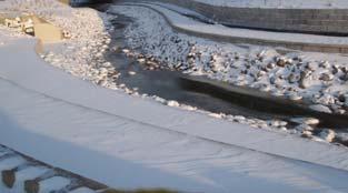

16 KKR Watercourse - January 2012 KKR Watercourse January


17 KKR Watercourse Rehabilitation Improvements Schedule Construction Start September 2010 Construction Completion May 2012 $1.5 Million Great Lakes Restoration Initiative Grant KK River Mainstem Projects 17

 Kinnickinnic River S.")
18 KKR Watercourse Rehabilitation Improvements Schedule S. 6 th Street S. 27 th Street Neighborhood Plan Completed 2010 Preliminary Engineering Completed 2011 Home Acquisition/Deconstruction Ongoing 83 Structure Acquisitions (Voluntary) 37 Structures Acquired To Date 25 Structures Deconstructed To Date Design & Construction Pending Funding S. 27 th Street to Jackson Park USACE Feasibility Study Ongoing (Sept 2012) Kinnickinnic River S. 6 th Street to I-94 SEH Project Team Members Dale Miller, Mainstream Restoration Rose Chmielewski, Ecological Services of Milwaukee Doug Bath, Gestra Engineering 18
Re: Survey of constructed cross section per Restoration Framework on Wind River, Fremont County, WY
 1-11-17 LeClair Irrigation District 1418 Cowboy Lane Riverton, WY 82501 (307) 856-4018 Re: Survey of constructed cross section per Restoration Framework on Wind River, Fremont County, WY Dear Mr. Hoelzen,
Technical Memorandum ECO-7
 To: Woody Frossard, TRWD From: Bob Brashear, CDM This document is released for the purpose of interim review under the authority of Robert Brashear, P.E., TX license 80771 on 21-Mar-2005. It is not to
East Chaska Creek Restoration Project
 East Chaska Creek Restoration Project Lower Minnesota River Watershed District & the City of Chaska East Chaska Creek Restoration Project Project No. 86550 February 2016 East Chaska Creek Restoration Project
Compensatory Mitigation Monitoring Report Aquatic Habitat Improvement City of Montrose Whitewater Park, Montrose County, Colorado March 6, 2014
 Compensatory Mitigation Monitoring Report Aquatic Habitat Improvement City of Montrose Whitewater Park, Montrose County, Colorado March 6, 2014 i. Project Overview 1. USACE # # SPK 2013 00851 2. Permittee:
Authorized Agent: City of Manassas Check List Attached: Contact: Address: Phone Number: Fax Number: Developer s Name: Phone Number:
 CITY OF MANASSAS DEPARTMENT OF COMMUNITY DEVELOPMENT DEVELOPMENT SERVICES DIVISION 9027 Center Street Room 201 Manassas, Virginia, 20110 Phone: 703-257-8278 Fax: 703-257-5831 Application Date: APPLICANT
Hogg Bird Sanctuary Study Frequently Asked Questions March 2017
 Hogg Bird Sanctuary Study Frequently Asked Questions March 2017 Study and Program Process What was the purpose of this study of Hogg Bird Sanctuary? In support of the Memorial Park Master Plan, the led
HEXAGONAL DOUBBLE TWISTED GABION & ROCK FALL MATRESSES
 Menufatchurar of HEXAGONAL DOUBBLE TWISTED GABION & ROCK FALL MATRESSES As per IS 16014 (2012): Mechanically woven, double -twisted, hexagonal Wire Mesh Gabions, Revet Mattresses and Rock fallnetting(
Ecological Restoration Drafting & Design Guidelines
 Ecological Restoration Drafting & Design Guidelines Version 2.0 July 2017 Philadelphia Water Ecological Restoration Drafting & Design Guidelines Table of Contents 1.0 INTRODUCTION...2 2.0 GENERAL PLAN
RE: Engineered Riffle Concepts for Sodom Dam Removal Grade Control Elements
 November 19, 2009 Ms. Melissa Jundt NOAA Fisheries Hydropower Division 1201 NE Lloyd Boulevard, Suite 1100 Portland, Oregon 97232 RE: Engineered Riffle Concepts for Sodom Dam Removal Grade Control Elements
Section 1. Introduction
 Overview of Manual Acknowledgements i x Section 1. Introduction 1.0 Overview of Section 1 1-1 1.1 The GESC and DESC Permits 1-2 1.2 Reasons for the GESC and DESC Permits 1-2 1.3 Legislative Mandate 1-3
City of Massillon Site Plan Checklist
 City of Massillon Site Plan Checklist The following information MUST be included with all Site Plans submitted for review and processing in order to constitute a complete Site Plan Package. Incomplete
ARTICLE 3: WATERSHED MANAGEMENT PERMIT REQUIREMENTS AND SUBMITTALS
 ARTICLE 3: WATERSHED MANAGEMENT PERMIT REQUIREMENTS AND SUBMITTALS Introduction This section provides guidance on the submittal requirements for a development to obtain a Watershed Management Permit from
UPPER MISSISSIPPI RIVER RESTORATION LAKE ODESSA HABITAT REHABILITATION AND ENHANCEMENT PROJECT OPERATION AND MAINTENANCE MANUAL APPENDIX F
 UPPER MISSISSIPPI RIVER RESTORATION LAKE ODESSA HABITAT REHABILITATION AND ENHANCEMENT PROJECT OPERATION AND MAINTENANCE MANUAL APPENDIX F PROJECT PHOTOGRAPHS Table of Photographs Photograph 1: Lake Odessa
B422 - PRECAST REINFORCED CONCRETE BOX CULVERTS AND BOX SEWERS - OPSS 422
 B422 - PRECAST REINFORCED CONCRETE BOX CULVERTS AND BOX SEWERS - OPSS 422 422.1 GENERAL The work under these tender items consists of the fabrication and installation in open cut of precast reinforced
FEMA Conditional Letter of Map Revision (CLOMR) Process. Shawn Arden, PE, CFM OTEC 2017
 Process. Shawn Arden, PE, CFM OTEC 2017") FEMA Conditional Letter of Map Revision (CLOMR) Process Shawn Arden, PE, CFM OTEC 2017 What is a CLOMR? CLOMR = Conditional Letter of Map Revision Letterissued by FEMA stating that a proposed project,
FEMA Conditional Letter of Map Revision (CLOMR) Process Shawn Arden, PE, CFM OTEC 2017 What is a CLOMR? CLOMR = Conditional Letter of Map Revision Letterissued by FEMA stating that a proposed project,
Floodplain Modeling 101. Presentation Goals
 Floodplain Modeling 101 Presenter: Joseph L. Miller, P.E., CFM 2016 INAFSM Conference Presentation Goals Introduction to Indiana s and FEMA s floodplain modeling technical requirements for riverine modeling
County Wetlands Board Minutes. July 8, 2008
 County Wetlands Board Minutes July 8, 2008 Call to Order The July 8, 2008 meeting of the Middlesex County Wetlands Board was called to order by Chairman Miller Smither at 9:00 A.M. in the Boardroom of
B.2 MAJOR SUBDIVISION PRELIMINARY PLAN CHECKLIST
 B.2 MAJOR SUBDIVISION PRELIMINARY PLAN CHECKLIST YES* GENERAL SUBMISSION ITEMS Does the submission include: 1. Thirteen (13) copies of completed Application Form? 2. Thirteen (13) copies of the Preliminary
Demolition of Ramp C (SN ): Westbound Ontario Street to Eastbound I-90/94) over I-90/94 (JF Kennedy Expressway)
: Westbound Ontario Street to Eastbound I-90/94) over I-90/94 (JF Kennedy Expressway)") I-90/94 (Kennedy Expressway) at Ohio Street Structure Replacement and Rehabilitation Section Number 0303-474HB-R D-91-177-09 Contract 60F63 Cook County, Region One, District One City of Chicago Project
I-90/94 (Kennedy Expressway) at Ohio Street Structure Replacement and Rehabilitation Section Number 0303-474HB-R D-91-177-09 Contract 60F63 Cook County, Region One, District One City of Chicago Project
Lakes and Rivers Division, David Dale
 Locks and Dams 2, 3, and 4 Monongahela River, PA (Lower Mon Project) Inland Waterways Users Board Lakes and Rivers Division, David Dale November 2014 David Dale, PE, PMP Braddock Dam US Army Corps of Engineers
Anne Arundel County Dept. of Inspections and Permits Storm Drain Checklist
 Project Name Project Number Engineer Plans are to be designed based on the standards set forth in the Anne Arundel County Design Manual Standards and Specifications, and all other manuals as stipulated
Information for File # RMM
 Information for File # 3-4-RMM Applicant:, L.P. Corps Contact: Ryan Malterud Address: 8 Fifth Street East, St. Paul, Minnesota 56 E-Mail: Ryan.M.Malterud@usace.army.mil Phone: (65) 9-586 Primary County:
ABC and Innovative Bridge Construction for Minnesota Local Roads
 ABC and Innovative Bridge Construction for Minnesota Local Roads May 23, 2013 To box the cha of t unl qua gra ma all g You ma add Tex Chris Werner, PE Senior Bridge Engineer HDR Engineering, Inc. 763-278-5918
ATTACHMENT H TACOMA HYDROELECTRIC PROJECT DESCRIPTION OF PROJECT FEATURES
 ATTACHMENT H TACOMA HYDROELECTRIC PROJECT DESCRIPTION OF PROJECT FEATURES The Tacoma Hydroelectric Project is located about 20 miles north of Durango, Colorado, on a high intermountain plateau west of
SITE PLAN, SUBDIVISION & EXTERIOR DESIGN REVIEW PROCESS
 INCORPORATED VILLAGE OF ROCKVILLE CENTRE BUILDING DEPARTMENT SITE PLAN, SUBDIVISION & EXTERIOR DESIGN REVIEW PROCESS Presubmission - Prior to a formal submission, the applicant should meet in person with
Application Submittal Checklist for a BASIC USE PERMIT (BUP) Planning & Development Department Planning Division
 Planning & Development Department Planning Division") Application Submittal Checklist for a BASIC USE PERMIT (BUP) APPLICABILITY. This checklist should be used when submitting an application for a Basic Use Permit. When is a Basic Use Permit required? Section
Application Submittal Checklist for a BASIC USE PERMIT (BUP) APPLICABILITY. This checklist should be used when submitting an application for a Basic Use Permit. When is a Basic Use Permit required? Section
DEVELOPMENT PLAN CHECKLIST
 Project Identification Information: DEVELOPMENT PLAN CHECKLIST 1.0 GENERAL 1.1 Additional information as required by specific Land Use 1.2 All sheets to include sheet number ( of ) 1.3 Seal and signature
Rebman Creek Evaluation of In-Stream Rehabilitation Structures
 Rebman Creek Evaluation of In-Stream Rehabilitation Structures Draft Report Prepared for: Weldwood of Canada Ltd. Quesnel, BC by: G3 Consulting Ltd. 4508 Beedie Street Burnaby, BC V5J 5L2 December 2000
Levee Risk Assessments
 Levee Risk Assessments Overview of the USACE Semi-Qualitative Risk Assessment Process for Levees Michael Kynett, PE Levee Safety Program Manager Sacramento District, USACE Levee State-of-the-Practice Symposium
APPENDIX B: DETAIL DRAWINGS OF SELECTED IMPROVEMENT TECHNIQUES
 APPENDIX B: DETAIL DRAWINGS OF SELECTED IMPROVEMENT TECHNIQUES This appendix provides schematic drawings (not to scale) that illustrate the materials, form, and construction of selected improvement techniques.
Porter County Plan Commission
 Plan Type: Development Plan Administrative DRC PC Primary Plan Administrative DRC PC Secondary Plat/Replat Administrative DRC PC PUD Conceptual Detailed Final Project Information Project Name: Developer
6/19/2014. Milton Madison Bridge Slide. Project Partners. The Challenge. Aaron L. Stover, PE, SE Michael Baker Jr., Inc.
 Kentucky Society of Professional Engineers May 23 rd, 2014 Lexington KY Milton Madison Bridge Slide Aaron L. Stover, PE, SE Michael Baker Jr., Inc. Project Partners The Challenge Milton, KY Existing Bridge
SECTION 100 PRELIMINARY CONSIDERATIONS & INSTRUCTIONS
 SECTION 100 PRELIMINARY CONSIDERATIONS & INSTRUCTIONS 101 General 102 Submittal Requirements A. Initial Submittal B. Second Submittal 103 Plan Requirements A. Subdivisions B. Site Plans 104 Approval of
APPENDIX I FLOODPLAIN ANALYSIS
 APPENDIX I FLOODPLAIN ANALYSIS TECHNICAL MEMORANDUM Date: June 11, 2014 To: Bibiana Alvarez and Ryan Lee Sawyer, Analytical Environmental Services From: Melanie Carr, MS, PE, Tarick Abu- Aly, MS, PE, Rafael
MINOR SUBDIVISION. [ ] [ ] [ ] [ ] B. Dimensions, bearings and curve data for all property lines and easements.
![MINOR SUBDIVISION. [ ] [ ] [ ] [ ] B. Dimensions, bearings and curve data for all property lines and easements.](/thumbs/90/102241643.jpg "MINOR SUBDIVISION. [ ] [ ] [ ] [ ] B. Dimensions, bearings and curve data for all property lines and easements.") MINOR SUBDIVISION 190-69. Minor subdivisions. In addition to the requirements indicated in 190-67 (SEE BELOW), the information below shall be shown on the plans for all minor subdivision applications.
MINOR SUBDIVISION 190-69. Minor subdivisions. In addition to the requirements indicated in 190-67 (SEE BELOW), the information below shall be shown on the plans for all minor subdivision applications.
ADDENDUM No. 1. ITB No Northside Interceptor Condition Assessment. Due: February 1, 2018 at 10:00 A.M. (Local Time)
") ADDENDUM No. 1 ITB No. 4521 Northside Interceptor Condition Assessment Due: February 1, 2018 at 10:00 A.M. (Local Time) The following changes, additions, and/or deletions shall be made to the Invitation
ADDENDUM No. 1 ITB No. 4521 Northside Interceptor Condition Assessment Due: February 1, 2018 at 10:00 A.M. (Local Time) The following changes, additions, and/or deletions shall be made to the Invitation
Caroline County Public Utilities Rate Increase Effective August 1, 2018
 Caroline County Public Utilities Rate Increase Effective August 1, 2018 Understanding your Water and Sewer Utility Bill Your water/sewer bill is made up of several different components, based on the type
Appendix B. Historical Aerial Photograph Review
 . Historical Aerial Photograph Review A historical aerial photo review was conducted to document changes in site use and layout at T-108 over time. Photos from 1936 (King County 2008), 1946 (Aerial Photo
LOT 1 PARKING FACILITY PLANNING COMMISSION HEARING Stadium Authority of the City of Pittsburgh April 5, 2016 WTW ARCHITECTS
 LOT 1 PARKING FACILITY PLANNING COMMISSION HEARING Stadium Authority of the City of Pittsburgh April 5, 2016 WTW ARCHITECTS Project Introduction Address: Chuck Noll Way & West General Robinson Street Zoning
REPORT TO COUNCIL DORWICK DITCH PETITION REHABILITATION PROJECT JUNE 8, 2016
 REPORT TO COUNCIL DORWICK DITCH PETITION REHABILITATION PROJECT JUNE 8, 2016 Based on a preliminary study by Euthenics, Inc. www.euthenics_inc.com 1 SECTION I GENERAL INFORMATION AND EXISTING CONDITIONS
City of Sparks. Fiscal Year 2008 Strategic Plan Progress Report
 City of Sparks Strategic Plan Progress Report Vision & Priorities Vision Statement: To be a city which embraces the changing needs and expectations of our citizens through respect for people, preserving
Performance Monitoring
 Performance Monitoring Rock Island District Kara N. Mitvalsky, P.E. CEMVR-EC-DN Traditional Reports Analysis of existing data Comparison of data points to objectives identified in the feasibility reports
Discovery Report Appendix L Dams and Floodplain Structures Lake Ontario St. Lawrence Watershed HUC
 Discovery Report Appendix L Dams and Floodplain Structures Lake Ontario St. Lawrence Watershed HUC 04150309 July 2016 Federal Emergency Management Agency Department of Homeland Security 26 Federal Plaza
CORPORATE PROFILE. The company has four principle owners three of which are charged with daily operations and management.
 CORPORATE PROFILE ORGANIZATION Highridge Partners, Inc. was formed in December 2001 to provide the growing Southeastern real estate market with an industry leading property development group. Our project
50.24 Type, Size and Location Plans for Culverts, Bridges and Culvert Bridges
 50.24 Culverts, Bridges and Culvert Bridges Type, Size and Location (T, S & L) Plans shall be required for all Bridges, Culvert Bridges and Culverts of eight-foot (8') clear span or greater as follows:
PRECAST CONCRETE BRIDGE SUBSTRUCTURE COMPONENTS. Presented by: Matthew Youngblood, PE, SE Scott Noyer, PE Janssen & Spaans Engineering
 PRECAST CONCRETE BRIDGE SUBSTRUCTURE COMPONENTS Presented by: Matthew Youngblood, PE, SE Scott Noyer, PE Janssen & Spaans Engineering PRECAST SUBSTRUCTURE COMPONENTS ADVANTAGES SCHEDULE INCREASES CONSTRUCTION
BRASELTON WATER AND WASTEWATER DEPARTMENT CONSTRUCTION PLAN REVIEW CHECKLIST May 2006
 Project Name: BRASELTON WATER AND WASTEWATER DEPARTMENT CONSTRUCTION PLAN REVIEW CHECKLIST May 2006 Phase: Unit: # Lots: Development Type (residential, commercial, industrial, etc.) Braselton Project No.
Lakes and Rivers Division, Mr. David Dale
 Locks and Dams 2, 3, and 4 Monongahela River, PA (Lower Mon Project) Inland Waterways Users Board Lakes and Rivers Division, Mr. David Dale 25 February 2015 Braddock Dam US Army Corps of Engineers Charleroi
Cat Island Chain Restoration Project Brown County Port & Resource Recovery Department
 Cat Island Chain Restoration Project Brown County Port & Resource Recovery Department February 2, 2015 Fox River and Lower Green Bay Cat Island Chain - 1938 Cat Island Brown County Aerial Photography,
King Road / CN Rail Grade Separation
 King Road / CN Rail Grade Separation A perfect confluence of environmental collaboration Project Proponents: Designers: Regulator: City of Burlington AMEC Environment & Infrastructure Conservation Halton
Iowa Bridge Sensor Demonstration Project Phase I and Phase II Executive Summary Report. Floodplain Management Services Silver Jackets Pilot Study
 Iowa Bridge Sensor Demonstration Project Phase I and Phase II Executive Summary Report Floodplain Management Services Silver Jackets Pilot Study Final Report AUGUST 2016 Iowa Bridge Sensor Demonstration
PLANNING AND DEVELOPMENT
 OVERVIEW Effective January 1, 1992 all applications for multi-family residential and all non-residential building permits require site plan approval before permit issuance. All new developments and existing
APPLICATION FOR SITE PREPARATION PERMIT
 Engineering Division 550 Landa Street New Braunfels, Texas 78130 (830) 221-4020 1. Subdivision/Plat Name: Location Description/ Nearest Intersection: Acreage: APPLICATION FOR SITE PREPARATION PERMIT No.
Please type or print legibly using blue or black ink. Incomplete applications cannot be accepted. Project Information. Address or Location:
 Rec d Rec d: GWINNETT COUNTY Department of Planning & Development One Justice Square 446 West Crogan Street, Suite 150 Lawrenceville, Georgia 30046 Phone: 678.518.6000 Fax: 678.518.6240 www.gwinnettcounty.com
FARM TO MARKET 1103 OPEN HOUSE PUBLIC MEETING. FM 1103 I-35 to Rodeo Dr
 FARM TO MARKET 1103 OPEN HOUSE PUBLIC MEETING March 29, 2016 FM 1103 FROM: I-35 TO: RODEO DR COMAL & GUADALUPE COUNTY OPEN HOUSE PUBLIC MEETING March 29, 2016 5:00 p.m. 7:00 p.m. Barbara C Jordan Intermediate
The Basics. HECRAS Basis Input. Geometry Data - the basics. Geometry Data. Flow Data. Perform Hydraulic Computations. Viewing the Output
 The Basics HECRAS Basis Input Geometry Data. Flow Data. Perform Hydraulic Computations by G. Parodi WRS ITC The Netherlands Viewing the Output ITC Faculty of Geo-Information Science and Earth Observation
Essential Skills: Reading and Interpreting Maps and Plans
 Essential Skills: Reading and Interpreting Maps and Plans Prepared for: NEW YORK STATE PLANNING FEDERATION April 14, 2015 Prepared by: BME ASSOCIATES Peter G. Vars, P.E. Stages of Plan Review Concept /
2018 District 1 Highway Construction Program
 District 1 Highway Construction Program For additional information contact: Stephanie Christensen MnDOT District 1, Public Affairs Office: 218-725-2700 Email: Stephanie.smith-christensen@state.mn.us Last
VARIANCE APPLICATION (NO SITE PLAN OR SUBDIVISION)
") VARIANCE APPLICATION (NO SITE PLAN OR SUBDIVISION) 190-66. General procedure for completeness review. A. In order to be determined complete for review by the Board, all of the required information must
VARIANCE APPLICATION (NO SITE PLAN OR SUBDIVISION) 190-66. General procedure for completeness review. A. In order to be determined complete for review by the Board, all of the required information must
Complex Systems Policy Analysis of Social- Ecological Systems Using Concept Mapping
 Policy analysis tools analyzing linear and singular policy issues are inadequate for complex socialecological systems (SES), and are often not easily understood by non-expert policy-makers and public stakeholders
SCOUR: EVALUATION AND RIPRAP. John G. Delphia, P.E. TxDOT Bridge Division Geotechnical Branch
 SCOUR: EVALUATION AND RIPRAP John G. Delphia, P.E. TxDOT Bridge Division Geotechnical Branch IMPORTANCE OF SCOUR The most common cause of bridge failures is from floods scouring bed material from around
APPENDIX K DEPARTMENT OF PLANNING AND CODE ENFORCEMENT SUBDIVISION APPLICATION CENTER SUBMITTAL CHECKLIST
 VI-K -1 of 8 APPENDIX K DEPARTMENT OF PLANNING AND CODE ENFORCEMENT SUBDIVISION APPLICATION CENTER SUBMITTAL CHECKLIST Final Submittal Major Subdivision Project Name Subdivision Number Location (Street
Texas Department of Transportation Book 2 - Technical Provisions. IH 35E Managed Lanes Project. Attachment 4-4. Section 4(f) Mitigation Master Plan
 Mitigation Master Plan") Texas Department of Transportation Book 2 - Technical Provisions IH 35E Managed Lanes Project Attachment 4-4 Section 4(f) Mitigation Master Plan IH 35E Managed Lanes Project Book 2 - Technical Provisions
Texas Department of Transportation Book 2 - Technical Provisions IH 35E Managed Lanes Project Attachment 4-4 Section 4(f) Mitigation Master Plan IH 35E Managed Lanes Project Book 2 - Technical Provisions
MAJOR GRADING PLAN CHECKLIST
 MAJOR GRADING PLAN CHECKLIST PUBLIC WORKS DEPARTMENT / ENGINEERING DIVISION 8130 Allison Avenue, La Mesa, CA 91942 Phone: (619) 667-1166 Fax: (619) 667-1380 Grading plans shall address both rough grading
MAKING THE MOST OF FLOODPLAIN BUYOUTS. Rebecca Kihslinger, Environmental Law Institute David Salvesen, University of North Carolina
 MAKING THE MOST OF FLOODPLAIN BUYOUTS Rebecca Kihslinger, Environmental Law Institute David Salvesen, University of North Carolina Logistics You are all on mute Type your questions in the question box
Subdivision Application Checklist
 City of Portsmouth, New Hampshire Subdivision Application Checklist This subdivision application checklist is a tool designed to assist the applicant in the planning process and for preparing the application
APPENDIX E CIVIL DESIGN (QUANTITY CALCULATION)
") APPENDIX E CIVIL DESIGN (QUANTITY CALCULATION) LOWER CACHE RIVER 1135 CIVIL DESIGN CALCULATIONS R2200, R90, & FILTER MATERIAL VOLUME CALCULATIONS FOR WEIR STRUCTURES EMBEDDED RIPRAP THICKNESS 4' 6'
APPENDIX E CIVIL DESIGN (QUANTITY CALCULATION) LOWER CACHE RIVER 1135 CIVIL DESIGN CALCULATIONS R2200, R90, & FILTER MATERIAL VOLUME CALCULATIONS FOR WEIR STRUCTURES EMBEDDED RIPRAP THICKNESS 4' 6'
CITY OF VISTA STANDARD DRAWINGS
 CITY OF VISTA STANDARD DRAWINGS May, 2015 THIS SHEET INTENTIONALLY LEFT BLANK TABLE OF CONTENTS MODIFICATIONS Modifications to San Diego Regional Standard Drawings DRAINAGE STRUCTURES DRN 01 Corrugated
September 21, Mannik Smith Group 1771 North Dixie Highway Monroe, Michigan RE: LA Fitness City File No.: CVLP
 CITY OF ANN ARBOR, MICHIGAN Public Services Area / Engineering 301 E. Huron Street, P.O. Box 8647 Ann Arbor, Michigan 48107 Phone (734) 794-6410 Fax (734) 994-1744 Web: www.a2gov.org Printed on recycled
B-PERMIT PLAN CHECK MANUAL
 B-PERMIT PLAN CHECK MANUAL 5. SEWER PLANS Sewer Plans are usually submitted in conjunction with Street Plans to meet the requirements of conditions imposed on a Planning or Zoning action. In some cases
CITY OF VISTA STANDARD DRAWINGS
 CITY OF VISTA STANDARD DRAWINGS May, 2015 THIS SHEET INTENTIONALLY LEFT BLANK TABLE OF CONTENTS MODIFICATIONS Modifications to San Diego Regional Standard Drawings DRAINAGE STRUCTURES DRN 01 Corrugated
 6'' W 8'' W 8'' W 4'' SAN 4'' SAN 2'' W 6'' W 6'' W INSTALL C.U. PAD (SEE MECHANICAL). M FM FM FM FM FM FM FM FM FM FM FM FM FM FM FM FM FM FM FM FM FM FM FM FM FM FM FM FM FM FM FM FM TOP OF TOP OF SW
CHRISTCHURCH CITY COUNCIL ARCHIVES
 Little River Road Board/Wairewa County Council CH770/1 Little River Road Board Minutes and Work Diary Oct 1865 Aug 1871 CH770/2 Little River Road Board Minutes Sept 1875 Jan 1875 CH770/3 Little River Road
PART XIII: HYDRAULIC/ HYDROLOGY SURVEYS
 PART XIII: HYDRAULIC/ HYDROLOGY SURVEYS 13.1 Purpose and Scope Hydraulic surveys are required for flow analysis to determine bridge and culvert design characteristics. A hydraulic survey is usually but
EVALUATION OF INTEGRITY OF AGED PENSTOCK SUPPORTING STRUCTURE IN HYDROELECTRIC GENERATING STATIONS
 EVALUATION OF INTEGRITY OF AGED PENSTOCK SUPPORTING STRUCTURE IN HYDROELECTRIC GENERATING STATIONS More info about this article: http://www.ndt.net/?id=22314 Abstract Janardhana.M*, Kishore kumar. G* and
Discovery Kick-Off Meeting Southeast Florida Coastal Study. May 30, 2014
 Discovery Kick-Off Meeting Southeast Florida Coastal Study May 30, 2014 Welcome and Introductions FEMA Region IV Mark Vieira Project Manager Christina Lindemer Technical Lead Henrietta Williams Outreach
DEVELOPMENT REVIEW COMMENTS LAND DISTURBANCE PERMIT (LDP) CLEARING CLEARING & GRUBBING GRADING. Date Reviewed by. Project Name
 CLEARING CLEARING & GRUBBING GRADING. Date Reviewed by. Project Name") GWINNETT COUNTY Department of Planning and Development One Justice Square 446 West Crogan Street Suite 150 1 st Floor Lawrenceville, GA 30046 Phone: 678.518.6000 Fax: 678.518.6240 www.gwinnettcounty.com
GWINNETT COUNTY Department of Planning and Development One Justice Square 446 West Crogan Street Suite 150 1 st Floor Lawrenceville, GA 30046 Phone: 678.518.6000 Fax: 678.518.6240 www.gwinnettcounty.com
Value Engineering Design Build MODULAR INFRASTRUCTURE
 Value Engineering Design Build MODULAR INFRASTRUCTURE VALUE ENGINEERING When infrastructure projects find themselves in densely populated areas, or occur on a site with poor conditions, the opportunity
A. ARTICLE 4 SKETCH PLAN REQUIREMENTS, MAJOR SUBDIVISION AND/OR LAND DEVELOPMENT
 400. 402.A. ARTICLE 4 SKETCH PLAN REQUIREMENTS, MAJOR SUBDIVISION AND/OR LAND DEVELOPMENT SECTION 400 PURPOSE The purpose of the Sketch Plan is to provide an opportunity for the applicant to consult early
Site Plan Review Application. Interest in the Property (e.g. fee simple, land option, etc.)
") 1. Identification CITY OF FENTON 301 South Leroy Street Fenton, Michigan 48430-2196 (810) 629-2261 FAX (810) 629-2004 Site Plan Review Application Project Name Applicant Name Address City/State/Zip Phone
1. Identification CITY OF FENTON 301 South Leroy Street Fenton, Michigan 48430-2196 (810) 629-2261 FAX (810) 629-2004 Site Plan Review Application Project Name Applicant Name Address City/State/Zip Phone
Town of Westlake Construction Plans Review Checklist
 CONSTRUCTION PLANS CONTENTS All Drawings 24 x 36 Cover Sheet Final Plat Site Plan Demolition Plan Utility Plan Drainage Area Map and Calculations Paving Plan & Profile Sheets Storm Drain Plan & Profile
Attachment #2 PPW133-07
 Attachment #2 PPW133-07 Pg. 1 EXECUTIVE SUMMARY Environmental Assessment Study In January 2005, Regional staff retained to commence a Schedule C Environmental Assessment Study to identify the improvements
Supporting Guidance Note
 Supporting Guidance Note Supporting Guidance Note: SGN 2 Geomorphology photosurveys for hydropower developments We require a geomorphology photosurvey to be submitted with applications for abstraction
TABLE OF CONTENTS 1200 PLAN PREPARATION
 1200 PLAN PREPARATION TABLE OF CONTENTS PAGE 1201 General Plan Sheet Information... 12-1 1201.1 Introduction... 12-1 1201.2 Unit of Measure... 12-1 1201.3 Plan Sheet Materials and File Format... 12-1 1201.4
NID Regional Water Supply Project Technical Memorandum
 NID Regional Water Supply Project Technical Memorandum Cross River Penstock Predesign January 2011 Prepared for Nevada Irrigation District City of Lincoln Prepared by Stantec Consulting Services Inc. 3875
Management Unit 2: East Beach to West Beach, Selsey
 Management Unit 2: East Beach to West Beach, Selsey Unit limits 4400m from 487200E, 094300N to 484450E, 093100N This Unit also forms Unit 1 of the South Downs SMP. Coastal processes The Selsey peninsula,
ENGINEERING SERVICES CONSULTANCY
 ENGINEERING SERVICES CONSULTANCY Managing complexity, unlocking value Petrofac Engineering & Production Services 02 03 Discover the difference Consultancy services Petrofac is an international service
INSTALLATION OF PYRAMAT ON SLOPES
 PYRAMAT SLOPE INSTALLATION AND MAINTENANCE GUIDELINES Thank you for purchasing our PYRAMAT High Performance Turf Reinforcement Mat (HPTRM) or Turf Reinforcement Mat (TRM) by Propex Operating Company, LLC
Strete to Limpet Rocks 6b75 and 6b76 SUMMARY OF PREFERRED PLAN RECOMMENDATIONS AND JUSTIFICATION
 Location reference: Policy Unit reference: Plan: Strete to Limpet Rocks 6b75 and 6b76 SUMMARY OF PREFERRED PLAN RECOMMENDATIONS AND JUSTIFICATION The coastline is characterised by vegetated sea cliffs,
MAINTENANCE HOLES, CATCH BASINS AND DITCH INLETS - MTC FORM 407 INDEX
 407-1 - MAINTENANCE HOLES, CATCH BASINS AND DITCH INLETS - MTC FORM 407 INDEX 407-1.1 GENERAL Tender Items Specifications Standard Drawings 407-1.1.1 Frame and Grate Selection 407-1.1.2 Selection of Structure
CITY OF ROHNERT PARK CITY COUNCIL AGENDA REPORT
 Mission Statement We Care for Our Residents by Working Together to Build a Better Community for Today and J Tomorrow. CITY COUNCIL AGENDA REPORT ITEM NO. 6.C.3 Meeting Date: January 13, 2015 Department:
Slope analysis & Grading. Earth shape and earthwork Topographic map Slope form Slope analysis Grading
 6 Slope analysis & Grading Earth shape and earthwork Topographic map Slope form Slope analysis Grading 81 Topographic Map Topographic Contour map Topographic contour map are composed of a series of line
This is a digital document from the collections of the Wyoming Water Resources Data System (WRDS) Library.
 Library.") This is a digital document from the collections of the Wyoming Water Resources Data System (WRDS) Library. For additional information about this document and the document conversion process, please contact
This is a digital document from the collections of the Wyoming Water Resources Data System (WRDS) Library. For additional information about this document and the document conversion process, please contact
Accelerated Bridge Construction (ABC) and the Utah Experience
 and the Utah Experience") Accelerated Bridge Construction (ABC) and the Utah Experience by Kris Peterson, P.E., UDOT Mary Lou Ralls, P.E., Ralls Newman, LLC AASHTO Subcommittee on Construction Annual Meeting Computers and Technology
Accelerated Bridge Construction (ABC) and the Utah Experience by Kris Peterson, P.E., UDOT Mary Lou Ralls, P.E., Ralls Newman, LLC AASHTO Subcommittee on Construction Annual Meeting Computers and Technology
MINUTES OF MEETING WHETSTONE HOMES CORPORATION Board of Directors May 11, 2017
 MINUTES OF MEETING WHETSTONE HOMES CORPORATION Board of Directors May 11, 2017 A regular meeting of the Whetstone Homes Corporation Board of Directors was held at 7:30 p.m. on Thursday, May 11, 2017 at
ACSA PLAN REVIEW CHECKLIST (Guideline Only) (4) Standard water and sewer general plan notes (attached).
 (4) Standard water and sewer general plan notes (attached).") ACSA PLAN REVIEW CHECKLIST (Guideline Only) Revised: December 3, 2015 General (1) Proper Title (2) Vicinity map on first sheet. (3) Date and latest plan revision. (4) Standard water and sewer general plan
ACSA PLAN REVIEW CHECKLIST (Guideline Only) Revised: December 3, 2015 General (1) Proper Title (2) Vicinity map on first sheet. (3) Date and latest plan revision. (4) Standard water and sewer general plan
SECTION DEWATERING TANKAGE PART 1 - GENERAL 1.1 RELATED DOCUMENTS
 SECTION 31 23 19 - DEWATERING TANKAGE PART 1 - GENERAL 1.1 RELATED DOCUMENTS A. Drawings and general provisions of the Contract, including General and Supplementary Conditions and Division 1 Specification
VISUAL INSPECTION CHECKLIST FOR GENERAL NPDES PERMIT FOR STORMWATER DISCHARGES ASSOCIATED WITH CONSTRUCTION ACTIVITIES (PAG-02)
") COMMONWEALTH OF PENNSYLVANIA DEPARTMENT OF ENVIRONMENTAL PROTECTION BUREAU OF WATERSHED MANAGEMENT VISUAL INSPECTION CHECKLIST FOR GENERAL NPDES PERMIT FOR STORMWATER DISCHARGES ASSOCIATED WITH CONSTRUCTION
COMMONWEALTH OF PENNSYLVANIA DEPARTMENT OF ENVIRONMENTAL PROTECTION BUREAU OF WATERSHED MANAGEMENT VISUAL INSPECTION CHECKLIST FOR GENERAL NPDES PERMIT FOR STORMWATER DISCHARGES ASSOCIATED WITH CONSTRUCTION
APPLICATION FOR PLANNED UNIT DEVELOPMENT (PUD) DEVELOPMENT PLAN
 DEVELOPMENT PLAN") 209 S. Main Street Marysville, Ohio 43040 Phone: (937) 645-7350 Fax: (937) 645-7351 www.marysvilleohio.org APPLICATION FOR PLANNED UNIT DEVELOPMENT (PUD) DEVELOPMENT PLAN *** IMPORTANT INFORMATION ~ Please
209 S. Main Street Marysville, Ohio 43040 Phone: (937) 645-7350 Fax: (937) 645-7351 www.marysvilleohio.org APPLICATION FOR PLANNED UNIT DEVELOPMENT (PUD) DEVELOPMENT PLAN *** IMPORTANT INFORMATION ~ Please
MSD STANDARD DRAWINGS LOUISVILLE AND JEFFERSON COUNTY METROPOLITAN SEWER DISTRICT 700 WEST LIBERTY STREET LOUISVILLE, KENTUCKY
 MSD M etr o p olitan S e w e r Di s t r ict STANDARD DRAWINGS LOUISVILLE AND JEFFERSON COUNTY METROPOLITAN SEWER DISTRICT 700 WEST LIBERTY STREET LOUISVILLE, KENTUCKY 40203-1911 STANDARD DRAWINGS DIVISION