UPPER MISSISSIPPI RIVER RESTORATION LAKE ODESSA HABITAT REHABILITATION AND ENHANCEMENT PROJECT OPERATION AND MAINTENANCE MANUAL APPENDIX F
|
|
|
- George Weaver
- 5 years ago
- Views:
Transcription
1 UPPER MISSISSIPPI RIVER RESTORATION LAKE ODESSA HABITAT REHABILITATION AND ENHANCEMENT PROJECT OPERATION AND MAINTENANCE MANUAL APPENDIX F PROJECT PHOTOGRAPHS
2
3 Table of Photographs Photograph 1: Lake Odessa Habitat Rehabilitation and Enhancement Project Ribbon Cutting (USACE 2017)... 1 Photograph 2: River Resources Coordinating Team Site Visit (Mitvalsky, USACE 2016)... 2 Photograph 3: Assistant Secretary of the Army Site Visit (USACE 2015)... 2 Photograph 4: Inlet Channel Preconstruction (USACE 2001)... 4 Photograph 5: Inlet Channel Excavation and Sidecast Material (Mitvalsky, USACE 2016)... 4 Photograph 6: Fields 4 and 5 Vegetation Prior to Flooding (Mitvalsky, USACE 2016)... 4 Photograph 7: Field 4 and 5 Vegetation Prior to Flooding (Mitvalsky, USACE 2016)... 4 Photograph 8: Fields 4 and 5 Pump Pad Location (Mitvalsky, USACE 2016)... 4 Photograph 9: Fields 4 and 5 Pump Pad (Mitvalsky, USACE 2017)... 4 Photograph 10: Fields 4 and 5 Ditch (Mitvalsky, USACE 2016)... 5 Photograph 11: Little Goose Pond Pump Pad Location Pre-Project (USACE)... 5 Photograph 12: Little Goose Pond Pump Pad (Mitvalsky, USACE 2013)... 5 Photograph 13: Little Goose Pond Pump Pad (Bolser, USFWS 2017)... 5 Photograph 14: Pre-Project Pumping Difficulties (USACE 2001)... 5 Photograph 15: Typical Temporary Pump, shown at Field 4 and 5 pump pad (Mitvalsky, USACE 2016) 5 Photograph 16: Temporary Pump Filling MSU (Mitvalsky, USACE 2005)... 6 Photograph 17: Muscatine Slough Water Control Structure (Bolser, USFWS 2017)... 7 Photograph 18: Muscatine Slough Water Control Structure (Mitvalsky, USACE 2017)... 7 Photograph 19: Mallards Resting behind Muscatine Slough Water Control Structure (Mitvalsky, USACE 2017)... 7 Photograph 20: Fox Pond Pre-Project (USACE 1995)... 7 Photograph 21: FWS MSU Pre-Project (USACE 1995)... 7 Photograph 22: Fox Pond at Water Control Structure (Mitvalsky, USACE 2016)... 7 Photograph 23: Fox Pond Water Control Structure with Stoplogs Removed (Mitvalsky/USACE)... 8 Photograph 24: Fox Pond Water Control Structure Stoplogs in Place (Mitvalsky, USACE 2016)... 8 Photograph 25: Pelicans in Fox Pond (Mitvalsky, USACE 2016)... 8 Photograph 26: Geese on Fox Pond (Bolser, USFWS 2016)... 8 Photograph 27: Snow Geese and Greater White-Fronted Geese Standing on a Mostly Frozen Fox Pond (Bolser, USFWS 2017)... 8 Photograph 28: Mallards over Fox Pond (Bolser, USFWS 2016)... 8 Photograph 29. Northern Pintails at Louisa Division (Bolser, USFWS 2016)... 9 Photograph 30 Canada Geese, Sandhill Cranes, and Pelicans on the Louisa Division (Bolser, USFWS 2016)... 9 Photograph 31: Solitary Sandpiper (Bolser, USFWS 2016)... 9 Photograph 32: Marsh Wren on Bulrush (Bolser, USFWS 2016)... 9 Photograph 33: Mallards, Ring-Necked Ducks, Northern Pintails and Green-Winged Teal (Bolser, USFWS 2016)... 9 Photograph 34: Mallards at Louisa Division (Bolser, USFWS 2016)... 9 Photograph 35: Northern Waterthrush Observed With a Group of Warblers in a Willow Thicket (Bolser, USFWS 2016) Photograph 36: IADNR MSU Water Control on Outside of MSU (Mitvalsky, USACE 2016) Photograph 37: IADNR MSU Structure (Mitvalsky, USACE 2016) Photograph 38: IADNR MSU Structure at Interior of MSU (Robbins, IADNR 2017)... 10
4 Photograph 39: IADNR MSU Final Grading (Mitvalsky, USACE 2012) Photograph 40: IADNR MSU after final grading (IADNR 2012) Photograph 41: IADNR MSU (Mitvalsky, USACE 2016) Photograph 42: IADNR MSU (Mitvalsky, USACE 2016) Photograph 43: Waterfowl use at Flooded IADNR MSU (Robbins, IADNR 2016) Photograph 44: Waterfowl Use at Flooded IADNR MSU (Robbins, IADNR 2016) Photograph 45: IADNR MSU Pump Pad Looking at Timber Stand Improvement Area (Mitvalsky, USACE 2011) Photograph 46: IADNR MSU Pump Pad Leading into Burris Ditch (Mitvalsky, USACE 2016) Photograph 47: View across proposed cuts from BeBee Pond, through BeBee/Swarms Cut, across Swarms Pond, through Swarms/Odessa Cut, across Lake Odessa and towards the bluff (USACE 2007). 12 Photograph 48: View across cuts from BeBee Pond Post Construction (Mitvalsky, USACE 2010) Photograph 49: Floating Excavator for Small Channel Cuts (Mitvalsky, USACE 2009) Photograph 50: Lake Odessa/Swarms Pond Dredge Cut and Sidecast Area (Mitvalsky, USACE 2009). 12 Photograph 51: Odessa/Swarms Cut Post Construction and Vegetated (Mitvalsky, USACE 2012) Photograph 52: Bebee Pond/Swarms Pond Placement Site (Mitvalsky USACE 2009) Photograph 53: BeBee Pond/Swarms Pond Placement Site (Mitvalsky, USACE 2009) Photograph 54: Levee Pre-Project (USACE 1994) Photograph 55: Levee Pre-Project (USACE 1994) Photograph 56: Levee Pre-Project (USACE 1994) Photograph 57: Dredge for Levee Sand (USACE 2007) Photograph 58: Sand Embankment (USACE 2007) Photograph 59: Sand Embankment (USACE 2008) Photograph 60: Levee Repairs (Mitvalsky, USACE 2008) Photograph 61: Top of Levee before seeding (Mitvalsky, USACE 2012) Photograph 62: Clay Cap preparation (USACE 2008) Photograph 63: Coyote on Levee surrounded by floodwater (Mitvalsky, USACE 2011) Photograph 64: Clay Cap Preparation (Mitvalsky, USACE 2011) Photograph 65: Delivering Clay for Two Foot Clay Cap (Mitvalsky, USACE 2011) Photograph 66: Excess Material Management (Mitvalsky, USACE 2011) Photograph 67: Smoothing Out Side Slopes after Clay Cap in Place (Mitvalsky, USACE 2011) Photograph 68: Levee Repairs Post Seeding (Robbins, IADNR 2016) Photograph 69: Restored Levee (Mitvalsky, USACE 2016) Photograph 70: Breach Repairs near Inlet (Mitvalsky, USACE 2016) Photograph 71: Breach Repairs near Inlet (Mitvalsky, USACE 2016) Photograph 72: Riprap Providing Flood Protection (Mitvalsky, USACE 2017) Photograph 73: Outlet Structure Being Constructed and Adjacent Levee Pre-Project (USACE 1995) Photograph 74: Erosion at Outlet after Sand Enhancement and the 2008 Flood (USACE 2008) Photograph 75: Riprap at Outlet Structure (USACE 2009) Photograph 76: Riprap at Outlet Structure (USACE 2009) Photograph 77: Low Water Crossing at Inlet (Harper, USACE 2012) Photograph 78: Low Water Crossing at Inlet with Gate (Harper, USACE 2011) Photograph 79: Temporary Crossing near outlet (Mitvalsky, USACE 2015) Photograph 80: Temporary Crossing near Outlet (Mitvalsky, USACE 2015) Photograph 81: Mississippi River Spillway (Mitvalsky, USACE 2016) Photograph 82: Mississippi River Spillway Access Road around Structure (Mitvalsky, USACE 2016).. 19 Photograph 83: Iowa River Upstream Spillway (Mitvalsky, USACE 2016)... 20
5 Photograph 84: Iowa River Downstream Spillway (Mitvalsky, USACE 2016) Photograph 85: Iowa River Spillway Overtopping (USACE 2008) Photograph 86: Iowa River Spillway Overtopping (USACE 2011) Photograph 87: Iowa River Spillway Overtopping (Robbins, IADNR 2011) Photograph 88: Iowa River Spillway Overtopping (Robbins, IADNR 2011) Photograph 89: Iowa River Spillway Starting to Overtop (Robbins, IADNR 9/29/2016) Photograph 90: Iowa River Spillway Overtopping (Robbins, IADNR 9/30/2016) Photograph 91: Iowa River Spillway Overtopping (Robbins, IADNR 10/3/2016) Photograph 92: New (Upstream) Iowa River Spillway Overtopping (Robbins, IADNR 9/30/2016) Photograph 93: New (Upstream) Iowa River Spillway Overtopping (Robbins, IADNR 10/3/2016) Photograph 94: Mississippi River Spillway (Robbins, IADNR 9/30/2016) Photograph 95: Ephemeral Wetland (Robbins, IADNR 2012) Photograph 96: Ephemeral Wetland (Robbins, IADNR 2012) Photograph 97: Ephemeral Wetland (Robbins, IADNR 2012) Photograph 98: Diamondback Water Snakes (Robbins, IADNR 2016) Photograph 99: Diamondback Water Snakes (Robbins, IADNR 2016) Photograph 100: Water Snake at Outlet Structure (Mitvalsky, USACE 2016) Photograph 101: Interior Wetland (Mitvalsky, USACE 2013) Photograph 102: Interior Wetland (Mitvalsky, USACE 2013) Photograph 103: Fisheries (Robbins, IADNR 2016) Photograph 104: Sanitation (Harper, USACE 2010) Photograph 105: Upper Goose Pond Cut (Mitvalsky, USACE 2010) Photograph 106: Upper Goose Pond Placement (Mitvalsky, USACE 2010) Photograph 107: Lower Goose Pond Placement (Mitvalsky, USACE 2010) Photograph 108: Lower Goose Pond in Water Placement (Mitvalsky, USACE 2010) Photograph 109: Middle Goose Pond Placement (Mitvalsky, USACE 2011) Photograph 110: Goose Pond Cut Off Berm (Mitvalsky, USACE 2012) Photograph 112: BeBee Pond Cut (Mitvalsky, USACE 2010) Photograph 113: Blackhawk Chute Yankee Chute (Mitvalsky, USACE 2008) Photograph 114: Blackhawk Chute Yankee Chute (Mitvalsky, USACE 2008) Photograph 115: South End of Blackhawk Chute (Mitvalsky, USACE 2010) Photograph 116: South End of Blackhawk Chute with placement sites on each side (Mitvalsky, USACE 2017) Photograph 117: North End of Blackhawk/Yankee Chute with Alignment Stakes (Mitvalsky, USACE 2010) Photograph 118: North End of Blackhawk/Yankee Chute Tree Clearing in Preparation for Dredged Material Placement (Mitvalsky, USACE 2011) Photograph 119: North End of Blackhawk Chute (Mitvalsky, USACE 2017) Photograph 120: Yankee Chute (Mitvalsky, USACE 2013) Photograph 121: Blackhawk Chute Material Recovery (USACE 2007) Photograph 122: Blackhawk Chute Material Recovery (USACE 2007) Photograph 123: Blackhawk Chute Excavation (USACE 2007) Photograph 124: Flood Inundation Line (USACE 1995) Photograph 125: Flood Line on Trees following the 2008 Flood (Mitvalsky, USACE 2009) Photograph 126: Post Flood Stress Pre-Project (USACE 2002) Photograph 127: Tree Planting (Harper, USACE 2010) Photograph 128: Tree Planting (Harper, USACE 2010)... 32
6 Photograph 129: Timber Stand Improvement Locations (Mitvalsky, USACE 2011) Photograph 130: Floodplain Forest TIMBER STAND IMPROVEMENT Area (Mitvalsky, USACE 2016) Photograph 131: Tree Planting (Lundh, USACE 2012) Photograph 132: Timber Stand Improvement, Tree Girdling (Lundh, USACE) Photograph 133: Tree Planting (Lundh, USACE 2012) Photograph 134: Selective Tree Clearing (Lundh, USACE 2012) Photograph 135: Tree Planting (Lundh, USACE 2012) Photograph 136: Tree Planting Site (Mitvalsky, USACE 2012) Photograph 137: Tree Planting on Dredged Material Berms (Mitvalsky, USACE 2017) Photograph 138: Fish Nursery Structure Original (USACE) Photograph 139: Fish Nursery Structure (Bolser, USFWS 2017) Photograph 140: Fish Nursery Screw Gate (Bolser, USFWS 2017) Photograph 141: Pre-Project Erosion Site 446 (Mitvalsky, USACE 2001) Photograph 142: Erosion Protection Site 446 (Robbins, IADNR 2017) Photograph 143: Site 98 & 99 riprap only (Mitvalsky, USACE 2008) Photograph 144: Site 98 & 98 Riprap and Sand Protection (Mitvalsky, USACE 2009) Photograph 145: Site 98 & 99 erosion protection (Mitvalsky, USACE 2009) Photograph 146: Recreational Use at Archeological Site Post Construction (Mitvalsky, USACE 2012). 38 Photograph 147: Site 424 Erosion Protection (Mitvalsky, USACE 2009) Photograph 148: Site 300 (Mitvalsky, USACE 2017) Photograph 149: Erosion Protection Site 30 (Robbins, IADNR 2017) Photograph 150: Erosion Protection Site 30 (Robbins, IADNR 2017) Photograph 151: Site 299 (Mitvalsky, USACE 2017) Photograph 152: Site 423 (Mitvalsky, USACE 2017) Photograph 153: Erosion Protection Site 27 (Mitvalsky, USACE 2017) Photograph 154: Ribbon Cutting Site Visit (2017) Photograph 155: Ribbon Cutting Site Visit (2017) Photograph 156: Ribbon Cutting Site Visit (2017) Photograph 157: IANDR (Robbins, Griffin) Observing Final Site (2016) Photograph 158: Fox Pond Lookout (2016) Photograph 159: USFWS Refuge Manager Cathy Nigg (2016) Photograph 160: Tree Clearing for Breach Repairs (2016) Photograph 161: Spillway Construction Oversight (2015) Photograph 162: Spillway Construction (2015) Photograph 163: Assistant Secretary of the Army Site Visit (2015) Photograph 164: 2014 Flood Damage Assessment with USFWS and USACE (2014) Photograph 165: 2014 Levee Breach Assessment (2014) Photograph 166: Levee Monument Discovered in Levee Breach (2013) Photograph 167: 2013 Flood Damage Assessment by Boat in Flooded Interior (2013) Photograph 168: 2013 Levee Damage Assessment (2013) Photograph 169: 2013 Flood Damage Assessment (2013) Photograph 170: Mississippi River Levee Breach near Outlet (USACE 2013) Photograph 171: Debris and Levee Damage (2013) Photograph 172: 2011 Flood Damage Assessment (2011) Photograph 173: Recreational Use at Archeological Site Following Protection (2011) Photograph 174: Contractor's Off Site Borrow Location (2012)... 45
7 Photograph 175: Clay Cap Work near Dredge Cut (2011) Photograph 176: Extra Sam from Clay Cap Preparation (2011) Photograph 177: Levee Grading (2011) Photograph 178: In Water Placement Sites (2011) Photograph 179: Forest Assessment (2010) Photograph 180: Connecting Channels (2009) Photograph 181: IADNR Review of Water Conditions (2008) Photograph 182: Construction Oversight (2008) Photograph 183: 2008 Flood Damage Assessment (2008) Photograph 184: Public Involvement in Site Observations (2008) Photograph 185: 2008 Flood Damage Assessment (2008) Photograph 186: Spillway Construction (2007) Photograph 187: Spillway Construction (2006) Photograph 188: Project Engineers (2006) Photograph 189: Multiagency Review of Proposed Features (2006) Photograph 190: Pump Inspection (2006) Photograph 191: USFWS Refuge Manager Tom Cox (2006) Photograph 192: USFWS Spillway (2005) Photograph 193: Constructing the USFWS Spillway (2004) Photograph 194: Forestry Meeting (2002) Photograph 195: Forestry Meeting (2002) Photograph 196: Initial Survey (2001) Photograph 197: 2001 Flood Damage Assessment (2001) Photograph 198: Hydraulic Engineer Review of Water Control Structures (2001) Photograph 199: Snake with a Copper Belly (2001) Photograph 200: 2001 Flood Damage Assessment (2001) Photograph 201: IANDR Observing Trees (2000) Photograph 202: Inlet Structure (2000) Photograph 203: 1993 Flood Damage Assessment (1995) Photograph 204: 1993 Flood Damage Assessment (1995) Photograph 205: 1993 Flood Damage Assessment (1995) Photograph 206: 1993 Flood Damage Assessment (1995) Photograph 207: Early Planning Meetings (1995)... 51
8
9 Photograph 1: Lake Odessa Habitat Rehabilitation and Enhancement Project Ribbon Cutting (USACE 2017) 1


10 Photograph 2: River Resources Coordinating Team Site Visit (Mitvalsky, USACE 2016) Photograph 3: Assistant Secretary of the Army Site Visit (USACE 2015) 2
11 Lake Odessa HREP Moist Soil Unit (MSU) Water Level Management 3
")
 Photograph 8: Fields 4 and 5 Pump Pad Location (Mitvalsky,")
 Photograph 9: Fields 4 and 5 Pump Pad (Mitvalsky,")
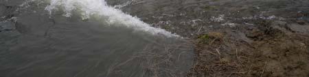
12 Photograph 4: Inlet Channel Preconstruction (USACE 2001) Photograph 7: Field 4 and 5 Vegetation Prior to Flooding (Mitvalsky, USACE 2016) Photograph 5: Inlet Channel Excavation and Sidecast Material (Mitvalsky, USACE 2016) Photograph 8: Fields 4 and 5 Pump Pad Location (Mitvalsky, USACE 2016) Photograph 6: Fields 4 and 5 Vegetation Prior to Flooding (Mitvalsky, USACE 2016) Photograph 9: Fields 4 and 5 Pump Pad (Mitvalsky, USACE 2017) 4
")


 Photograph 12: Little")
")

13 Photograph 10: Fields 4 and 5 Ditch (Mitvalsky, USACE 2016) Photograph 13: Little Goose Pond Pump Pad (Bolser, USFWS 2017) Photograph 11: Little Goose Pond Pump Pad Location Pre-Project (USACE) Photograph 14: Pre-Project Pumping Difficulties (USACE 2001) Photograph 12: Little Goose Pond Pump Pad (Mitvalsky, USACE 2013) Photograph 15: Typical Temporary Pump, shown at Field 4 and 5 pump pad (Mitvalsky, USACE 2016) 5

14 Photograph 16: Temporary Pump Filling MSU (Mitvalsky, USACE 2005) 6
 Photograph 20: Fox Pond")
")

 7")
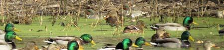
15 Photograph 17: Muscatine Slough Water Control Structure (Bolser, USFWS 2017) Photograph 20: Fox Pond Pre-Project (USACE 1995) Photograph 18: Muscatine Slough Water Control Structure (Mitvalsky, USACE 2017) Photograph 21: FWS MSU Pre-Project (USACE 1995) Photograph 19: Mallards Resting behind Muscatine Slough Water Control Structure (Mitvalsky, USACE 2017) Photograph 22: Fox Pond at Water Control Structure (Mitvalsky, USACE 2016) 7

")


")
16 Photograph 23: Fox Pond Water Control Structure with Stoplogs Removed (Mitvalsky/USACE) Photograph 26: Geese on Fox Pond (Bolser, USFWS 2016) Photograph 24: Fox Pond Water Control Structure Stoplogs in Place (Mitvalsky, USACE 2016) Photograph 27: Snow Geese and Greater White-Fronted Geese Standing on a Mostly Frozen Fox Pond (Bolser, USFWS 2017) Photograph 25: Pelicans in Fox Pond (Mitvalsky, USACE 2016) Photograph 28: Mallards over Fox Pond (Bolser, USFWS 2016) 8

")


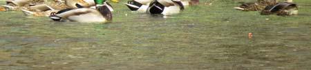
17 Photograph 29. Northern Pintails at Louisa Division (Bolser, USFWS 2016) Photograph 32: Marsh Wren on Bulrush (Bolser, USFWS 2016) Photograph 30 Canada Geese, Sandhill Cranes, and Pelicans on the Louisa Division (Bolser, USFWS 2016) Photograph 33: Mallards, Ring-Necked Ducks, Northern Pintails and Green-Winged Teal (Bolser, USFWS 2016) Photograph 31: Solitary Sandpiper (Bolser, USFWS 2016) Photograph 34: Mallards at Louisa Division (Bolser, USFWS 2016) 9

")


 Photograph 39: IADNR MSU")
 Photograph 37: IADNR MSU")
 Photograph 40: IADNR MSU")
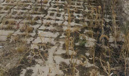
18 Photograph 35: Northern Waterthrush Observed With a Group of Warblers in a Willow Thicket (Bolser, USFWS 2016) Photograph 38: IADNR MSU Structure at Interior of MSU (Robbins, IADNR 2017) Photograph 36: IADNR MSU Water Control on Outside of MSU (Mitvalsky, USACE 2016) Photograph 39: IADNR MSU Final Grading (Mitvalsky, USACE 2012) Photograph 37: IADNR MSU Structure (Mitvalsky, USACE 2016) Photograph 40: IADNR MSU after final grading (IADNR 2012) 10
 Photograph 44: Waterfowl Use at")


 11")
19 Photograph 41: IADNR MSU (Mitvalsky, USACE 2016) Photograph 44: Waterfowl Use at Flooded IADNR MSU (Robbins, IADNR 2016) Photograph 42: IADNR MSU (Mitvalsky, USACE 2016) Photograph 43: Waterfowl use at Flooded IADNR MSU (Robbins, IADNR 2016) Photograph 45: IADNR MSU Pump Pad Looking at Timber Stand Improvement Area (Mitvalsky, USACE 2011) 11
 Photograph 46:")
 Photograph 49: Floating")
 Photograph 47: View across proposed cuts from")


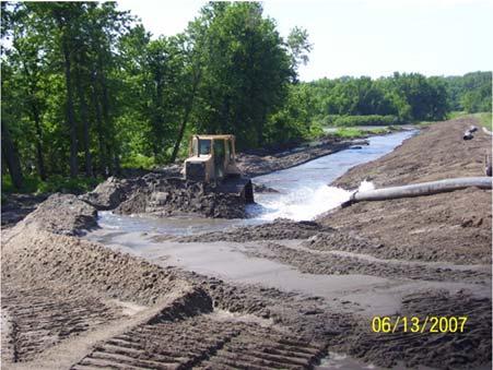
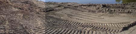
20 Photograph 48: View across cuts from BeBee Pond Post Construction (Mitvalsky, USACE 2010) Photograph 46: IADNR MSU Pump Pad Leading into Burris Ditch (Mitvalsky, USACE 2016) Photograph 49: Floating Excavator for Small Channel Cuts (Mitvalsky, USACE 2009) Photograph 47: View across proposed cuts from BeBee Pond, through BeBee/Swarms Cut, across Swarms Pond, through Swarms/Odessa Cut, across Lake Odessa and towards the bluff (USACE 2007) Photograph 50: Lake Odessa/Swarms Pond Dredge Cut and Sidecast Area (Mitvalsky, USACE 2009) 12
 Photograph 52: Bebee")

21 Photograph 51: Odessa/Swarms Cut Post Construction and Vegetated (Mitvalsky, USACE 2012) Photograph 52: Bebee Pond/Swarms Pond Placement Site (Mitvalsky USACE 2009) Photograph 53: BeBee Pond/Swarms Pond Placement Site (Mitvalsky, USACE 2009) 13
22 Lake Odessa HREP Levee Restoration 14

")


23 Photograph 56: Levee Pre-Project (USACE 1994) Photograph 54: Levee Pre-Project (USACE 1994) Photograph 57: Dredge for Levee Sand (USACE 2007) Photograph 55: Levee Pre-Project (USACE 1994) Photograph 58: Sand Embankment (USACE 2007) 15
")
")
")

 Photograph 61: Top of")
")
24 Photograph 59: Sand Embankment (USACE 2008) Photograph 62: Clay Cap preparation (USACE 2008) Photograph 60: Levee Repairs (Mitvalsky, USACE 2008) Photograph 63: Coyote on Levee surrounded by floodwater (Mitvalsky, USACE 2011) Photograph 61: Top of Levee before seeding (Mitvalsky, USACE 2012) Photograph 64: Clay Cap Preparation (Mitvalsky, USACE 2011) 16


")


 17")
25 Photograph 68: Levee Repairs Post Seeding (Robbins, IADNR 2016) Photograph 65: Delivering Clay for Two Foot Clay Cap (Mitvalsky, USACE 2011) Photograph 66: Excess Material Management (Mitvalsky, USACE 2011) Photograph 69: Restored Levee (Mitvalsky, USACE 2016) Photograph 67: Smoothing Out Side Slopes after Clay Cap in Place (Mitvalsky, USACE 2011) Photograph 70: Breach Repairs near Inlet (Mitvalsky, USACE 2016) 17
 Photograph 74:")
 Photograph")
 Photograph 75:")

 Photograph 76: 18")
26 Photograph 71: Breach Repairs near Inlet (Mitvalsky, USACE 2016) Photograph 74: Erosion at Outlet after Sand Enhancement and the 2008 Flood (USACE 2008) Photograph 72: Riprap Providing Flood Protection (Mitvalsky, USACE 2017) Photograph 75: Riprap at Outlet Structure (USACE 2009) Photograph 73: Outlet Structure Being Constructed and Adjacent Levee Pre-Project (USACE 1995) Photograph 76: Riprap at Outlet Structure (USACE 2009) 18
 Photograph 80:")
 Photograph 78: Low Water")
 Photograph 81: Mississippi River")


27 Photograph 77: Low Water Crossing at Inlet (Harper, USACE 2012) Photograph 80: Temporary Crossing near Outlet (Mitvalsky, USACE 2015) Photograph 78: Low Water Crossing at Inlet with Gate (Harper, USACE 2011) Photograph 81: Mississippi River Spillway (Mitvalsky, USACE 2016) Photograph 79: Temporary Crossing near outlet (Mitvalsky, USACE 2015) Photograph 82: Mississippi River Spillway Access Road around Structure (Mitvalsky, USACE 2016) 19


 Photograph 84: Iowa")

")
 Photograph 88: Iowa")
28 Photograph 83: Iowa River Upstream Spillway (Mitvalsky, USACE 2016) Photograph 86: Iowa River Spillway Overtopping (USACE 2011) Photograph 84: Iowa River Downstream Spillway (Mitvalsky, USACE 2016) Photograph 87: Iowa River Spillway Overtopping (Robbins, IADNR 2011) Photograph 85: Iowa River Spillway Overtopping (USACE 2008) Photograph 88: Iowa River Spillway Overtopping (Robbins, IADNR 2011) 20


 Photograph 90:")
")
29 Photograph 89: Iowa River Spillway Starting to Overtop (Robbins, IADNR 9/29/2016) Photograph 91: Iowa River Spillway Overtopping (Robbins, IADNR 10/3/2016) Photograph 90: Iowa River Spillway Overtopping (Robbins, IADNR 9/30/2016) Photograph 92: New (Upstream) Iowa River Spillway Overtopping (Robbins, IADNR 9/30/2016) 21
 Iowa River")
")

30 Photograph 93: New (Upstream) Iowa River Spillway Overtopping (Robbins, IADNR 10/3/2016) Photograph 94: Mississippi River Spillway (Robbins, IADNR 9/30/2016) 22
31 Lake Odessa HREP Ephemeral Wetlands 23
")


 24")
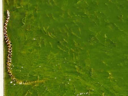
32 Photograph 95: Ephemeral Wetland (Robbins, IADNR 2012) Photograph 98: Diamondback Water Snakes (Robbins, IADNR 2016) Photograph 96: Ephemeral Wetland (Robbins, IADNR 2012) Photograph 99: Diamondback Water Snakes (Robbins, IADNR 2016) Photograph 97: Ephemeral Wetland (Robbins, IADNR 2012) Photograph 100: Water Snake at Outlet Structure (Mitvalsky, USACE 2016) 24
")
33 Photograph 101: Interior Wetland (Mitvalsky, USACE 2013) Photograph 102: Interior Wetland (Mitvalsky, USACE 2013) 25
34 Lake Odessa HREP Aquatic Diversity Fisheries Enhancement 26


35 Photograph 105: Upper Goose Pond Cut (Mitvalsky, USACE 2010) Photograph 103: Fisheries (Robbins, IADNR 2016) Photograph 106: Upper Goose Pond Placement (Mitvalsky, USACE 2010) Photograph 104: Sanitation (Harper, USACE 2010) Photograph 107: Lower Goose Pond Placement (Mitvalsky, USACE 2010) 27
 Photograph 111: Goose Pond Berm Shaping to Control Top Height")
 Photograph 112: BeBee Pond Cut (Mitvalsky,")
 Photograph 113: Blackhawk Chute Yankee Chute (Mitvalsky, USACE")
36 Photograph 108: Lower Goose Pond in Water Placement (Mitvalsky, USACE 2010) Photograph 111: Goose Pond Berm Shaping to Control Top Height (Mitvalsky, USACE 2011) Photograph 109: Middle Goose Pond Placement (Mitvalsky, USACE 2011) Photograph 112: BeBee Pond Cut (Mitvalsky, USACE 2010) Photograph 110: Goose Pond Cut Off Berm (Mitvalsky, USACE 2012) Photograph 113: Blackhawk Chute Yankee Chute (Mitvalsky, USACE 2008) 28
 Photograph 117: North")
 Photograph")
 Photograph 118: North End of")


37 Photograph 114: Blackhawk Chute Yankee Chute (Mitvalsky, USACE 2008) Photograph 117: North End of Blackhawk/Yankee Chute with Alignment Stakes (Mitvalsky, USACE 2010) Photograph 115: South End of Blackhawk Chute (Mitvalsky, USACE 2010) Photograph 118: North End of Blackhawk/Yankee Chute Tree Clearing in Preparation for Dredged Material Placement (Mitvalsky, USACE 2011) Photograph 116: South End of Blackhawk Chute with placement sites on each side (Mitvalsky, USACE 2017) Photograph 119: North End of Blackhawk Chute (Mitvalsky, USACE 2017) 29


 Photograph 121:")
 Photograph")
38 Photograph 123: Blackhawk Chute Excavation (USACE 2007) Photograph 120: Yankee Chute (Mitvalsky, USACE 2013) Photograph 121: Blackhawk Chute Material Recovery (USACE 2007) Photograph 122: Blackhawk Chute Material Recovery (USACE 2007) 30
39 Lake Odessa HREP Floodplain Forest 31
 Photograph 127: Tree")

 Photograph 128: Tree")
 Photograph")
 32")
40 Photograph 124: Flood Inundation Line (USACE 1995) Photograph 127: Tree Planting (Harper, USACE 2010) Photograph 125: Flood Line on Trees following the 2008 Flood (Mitvalsky, USACE 2009) Photograph 128: Tree Planting (Harper, USACE 2010) Photograph 126: Post Flood Stress Pre- Project (USACE 2002) Photograph 129: Timber Stand Improvement Locations (Mitvalsky, USACE 2011) 32

 Photograph 133:")
 Photograph 131: 2012)")
")

 33")
41 Photograph 130: Floodplain Forest TIMBER STAND IMPROVEMENT Area (Mitvalsky, USACE 2016) Photograph 133: Tree Planting (Lundh, USACE 2012) Photograph 131: Tree Planting (Lundh, USACE 2012) Photograph 134: Selective Tree Clearing (Lundh, USACE 2012) Photograph 132: Timber Stand Improvement, Tree Girdling (Lundh, USACE) Photograph 135: Tree Planting (Lundh, USACE 2012) 33
")
42 Photograph 136: Tree Planting Site (Mitvalsky, USACE 2012) Photograph 137: Tree Planting on Dredged Material Berms (Mitvalsky, USACE 2017) 34
43 Lake Odessa HREP Fish Nursery 35
")


44 Photograph 138: Fish Nursery Structure Original (USACE) Photograph 139: Fish Nursery Structure (Bolser, USFWS 2017) Photograph 140: Fish Nursery Screw Gate (Bolser, USFWS 2017) 36
45 Lake Odessa HREP Shoreline Protection of Historic Sites 37
 Photograph 144: Site")
 Photograph 145: Site")
 Photograph 142: Erosion Protection Site")


46 Photograph 141: Pre-Project Erosion Site 446 (Mitvalsky, USACE 2001) Photograph 144: Site 98 & 98 Riprap and Sand Protection (Mitvalsky, USACE 2009) Photograph 145: Site 98 & 99 erosion protection (Mitvalsky, USACE 2009) Photograph 142: Erosion Protection Site 446 (Robbins, IADNR 2017) Photograph 143: Site 98 & 99 riprap only (Mitvalsky, USACE 2008) Photograph 146: Recreational Use at Archeological Site Post Construction (Mitvalsky, USACE 2012) 38
 Photograph 150:")
 Photograph 148: Site 300 (Mitvalsky,")
 Photograph 149:")
 39")
47 Photograph 147: Site 424 Erosion Protection (Mitvalsky, USACE 2009) Photograph 150: Erosion Protection Site 30 (Robbins, IADNR 2017) Photograph 148: Site 300 (Mitvalsky, USACE 2017) Photograph 151: Site 299 (Mitvalsky, USACE 2017) Photograph 149: Erosion Protection Site 30 (Robbins, IADNR 2017) Photograph 152: Site 423 (Mitvalsky, USACE 2017) 39
48 Photograph 153: Erosion Protection Site 27 (Mitvalsky, USACE 2017) 40
49 LAKE ODESSA HREP PLANNING, DESIGN, CONSTRUCTION, AND FLOODS 41
 Observing")
 Photograph 158: Fox Pond Lookout")
 Photograph 159: USFWS Refuge Manager Cathy")
50 Photograph 154: Ribbon Cutting Site Visit (2017) Photograph 157: IANDR (Robbins, Griffin) Observing Final Site (2016) Photograph 155: Ribbon Cutting Site Visit (2017) Photograph 158: Fox Pond Lookout (2016) Photograph 156: Ribbon Cutting Site Visit (2017) Photograph 159: USFWS Refuge Manager Cathy Nigg (2016) 42
")


 Photograph 162:")

51 Photograph 160: Tree Clearing for Breach Repairs (2016) Photograph 163: Assistant Secretary of the Army Site Visit (2015) Photograph 161: Spillway Construction Oversight (2015) Photograph 164: 2014 Flood Damage Assessment with USFWS and USACE (2014) Photograph 162: Spillway Construction (2015) Photograph 165: 2014 Levee Breach Assessment (2014) 43

")


 Photograph 168:")
 Photograph 171: Debris")
52 Photograph 166: Levee Monument Discovered in Levee Breach (2013) Photograph 169: 2013 Flood Damage Assessment (2013) Photograph 167: 2013 Flood Damage Assessment by Boat in Flooded Interior (2013) Photograph 170: Mississippi River Levee Breach near Outlet (USACE 2013) Photograph 168: 2013 Levee Damage Assessment (2013) Photograph 171: Debris and Levee Damage (2013) 44
")
")


 Photograph 174:")
 Photograph")
53 Photograph 172: 2011 Flood Damage Assessment (2011) Photograph 175: Clay Cap Work near Dredge Cut (2011) Photograph 173: Recreational Use at Archeological Site Following Protection (2011) Photograph 176: Extra Sam from Clay Cap Preparation (2011) Photograph 174: Contractor's Off Site Borrow Location (2012) Photograph 177: Levee Grading (2011) 45


 Photograph 180:")
 Photograph 183:")
54 Photograph 178: In Water Placement Sites (2011) Photograph 181: IADNR Review of Water Conditions (2008) Photograph 179: Forest Assessment (2010) Photograph 182: Construction Oversight (2008) Photograph 180: Connecting Channels (2009) Photograph 183: 2008 Flood Damage Assessment (2008) 46

")


")


55 Photograph 184: Public Involvement in Site Observations (2008) Photograph 187: Spillway Construction (2006) Photograph 185: 2008 Flood Damage Assessment (2008) Photograph 188: Project Engineers (2006) Photograph 186: Spillway Construction (2007) Photograph 189: Multiagency Review of Proposed Features (2006) 47
")


 Photograph 194:")
 Photograph 192:")

56 Photograph 190: Pump Inspection (2006) Photograph 193: Constructing the USFWS Spillway (2004) Photograph 191: USFWS Refuge Manager Tom Cox (2006) Photograph 194: Forestry Meeting (2002) Photograph 192: USFWS Spillway (2005) Photograph 195: Forestry Meeting (2002) 48
 Photograph")
 Photograph")
")


57 Photograph 196: Initial Survey (2001) Photograph 199: Snake with a Copper Belly (2001) Photograph 197: 2001 Flood Damage Assessment (2001) Photograph 200: 2001 Flood Damage Assessment (2001) Photograph 198: Hydraulic Engineer Review of Water Control Structures (2001) 49


")


58 Photograph 204: 1993 Flood Damage Assessment (1995) Photograph 201: IANDR Observing Trees (2000) Photograph 202: Inlet Structure (2000) Photograph 205: 1993 Flood Damage Assessment (1995) Photograph 203: 1993 Flood Damage Assessment (1995) 50


59 Photograph 206: 1993 Flood Damage Assessment (1995) Photograph 207: Early Planning Meetings (1995) 51
60
Performance Monitoring
 Performance Monitoring Rock Island District Kara N. Mitvalsky, P.E. CEMVR-EC-DN Traditional Reports Analysis of existing data Comparison of data points to objectives identified in the feasibility reports
Environmental Management Program (EMP)
") Environmental Management Program (EMP) 2005 Governor s Conference on Management of the Illinois River System By Marvin Hubbell The Upper Mississippi River System Environmental Management Program (UMRS-EMP)
Environmental Management Program (EMP) 2005 Governor s Conference on Management of the Illinois River System By Marvin Hubbell The Upper Mississippi River System Environmental Management Program (UMRS-EMP)
River s End Ranch BCS number: 48-21
 Oregon Coordinated Aquatic Bird Monitoring: Description of Important Aquatic Bird Site River s End Ranch BCS number: 48-21 Site description author(s) Martin St. Lewis, Area Manager, Summer Lake Wildlife
WATER BIRDS OF PALM BEACH COUNTY
 WATER BIRDS OF PALM BEACH COUNTY Presented by : The Audubon Society of the Everglades www.auduboneverglades.org Text and Photographs by Larry Hess Types of Water Birds Seen in Palm Beach County Ducks and
Baskett Slough National Wildlife Refuge BCS number: 47-4
 Baskett Slough National Wildlife Refuge BCS number: 47-4 Site description author(s) Daphne E. Swope, Research and Monitoring Team, Klamath Bird Observatory Primary contact for this site N/A Location (UTM)
Sauvie Island Wildlife Area BCS number: 47-28
 Sauvie Island Wildlife Area BCS number: 47-28 Site description author(s) Mark Nebeker, Oregon Department of Fish and Wildlife, Sauvie Island Wildlife Area Manager Primary contact for this site Mark Nebeker,
ASSESSING HABITAT QUALITY FOR PRIORITY WILDLIFE SPECIES IN COLORADO WETLANDS
 C O L O R A D O P A R K S Dabbling Ducks & W I L D L I F E GADWALL TOM KOERNER, USFWS / AMERICAN WIGEON BILL GRACEY NORTHERN PINTAIL GEORGIA HART / MALLARD MICHAEL MENEFEE, CNHP / ALL TEAL PHOTOS TOM KOERNER,
Cat Island Chain Restoration Project Brown County Port & Resource Recovery Department
 Cat Island Chain Restoration Project Brown County Port & Resource Recovery Department February 2, 2015 Fox River and Lower Green Bay Cat Island Chain - 1938 Cat Island Brown County Aerial Photography,
Wetland Restoration at Blackwater NWR. Dixie Birch November 2, 2006
 Wetland Restoration at Blackwater NWR Dixie Birch November 2, 2006 Goal: Restore 20,000 acres In Dorchester County including 11,000 at Blackwater Strategic Partnerships Remaining marsh shown in red Blackwater
McNabney Marsh Nesting Bird Surveys
 McNabney Marsh 2014 Nesting Bird Surveys Prepared for: Mt View Sanitary District PO Box 2757 Martinez, CA 94553 Contact: Kelly Davidson 925.228.5635 Prepared by: PO Box 188888 Sacramento, CA 95818 Contact:
Upper Klamath National Wildlife Refuge Complex Upper Klamath Unit and Hank s Marsh Unit BCS Number: 48-29
 Oregon Coordinated Aquatic Bird Monitoring: Description of Important Aquatic Bird Site Upper Klamath National Wildlife Refuge Complex Upper Klamath Unit and Hank s Marsh Unit BCS Number: 48-29 Site description
Wanaket Wildlife Area BCS number: 48-30
 Oregon Coordinated Aquatic Bird Monitoring: Description of Important Aquatic Bird Site Wanaket Wildlife Area BCS number: 48-30 Site description author(s) M. Cathy Nowak, ODFW, Ladd Marsh Wildlife Area
MDWFP Aerial Waterfowl Survey Report. January 3-6, 2018
 MDWFP Aerial Waterfowl Survey Report January 3-6, 2018 Prepared by: Houston Havens Waterfowl Program Coordinator and Alec Conrad Private Lands Biologist Delta Region MS Department of Wildlife, Fisheries,
* * * * * * * * * * * * * * * * For Judges Use Only
 Welcome to the Wildlife O-Rama! SENIOR KEY NAME: COUNTY: * * * * * * * * * * * * * * * * For Judges Use Only Score Wildlife ID (30 pts) Wildlife Foods (15 pts) Wildlife Concepts (15 pts) Total RANK: Wildlife
Tualatin River NWR and Wapato Lake BCS number: 47-37
 Tualatin River NWR and Wapato Lake BCS number: 47-37 ***NOTE: We were unable to determine all necessary information for this site description. If you would like to contribute the needed information to
Toronto s Urban Wilderness
 Tommy Thompson Park Toronto s Urban Wilderness Park History Early Construction Construction began in 1959 by Toronto Harbour Commissioners Expand port related facilities Dispose of rubble and fill from
Wildlife Habitat Management on State Forest and Wildlife Lands
 Wildlife Habitat Management on State Forest and Wildlife Lands State Forests are managed within a sustainable forestry framework under an approved management plan. Sustainability includes managing the
Technical Memorandum ECO-7
 To: Woody Frossard, TRWD From: Bob Brashear, CDM This document is released for the purpose of interim review under the authority of Robert Brashear, P.E., TX license 80771 on 21-Mar-2005. It is not to
Northeast Florida Coastal Wetland Restoration Program A Partnership Based Regional Approach for Estuary Habitat Restoration
 Northeast Florida Coastal Wetland Restoration Program A Partnership Based Regional Approach for Estuary Habitat Restoration Paul Haydt Restore America s Estuaries November 15, 2010 St Johns River Water
McKay Creek National Wildlife Refuge BCS number: 48-19
 Oregon Coordinated Aquatic Bird Monitoring: Description of Important Aquatic Bird Site McKay Creek National Wildlife Refuge BCS number: 48-19 Site description author(s) Howard Browers, Supervisory Wildlife
Warner Wetlands / Warner Valley BCS number: 48-31
 Oregon Coordinated Aquatic Bird Monitoring: Description of Important Aquatic Bird Site Warner Wetlands / Warner Valley BCS number: 48-31 Site description author(s) Vernon Stofleth, Lakeview BLM District
Smith and Bybee Wetlands Natural Area BCS number 47-33
 Smith and Bybee Wetlands Natural Area BCS number 47-33 Site description author(s) Elaine Stewart, Smith and Bybee Lakes Wildlife Area Manager Danielle Morris, Research and Monitoring Team, Klamath Bird
Collaboration and Planning to Implement the South San Diego Bay Restoration and Enhancement Project
 Collaboration and Planning to Implement the South San Diego Bay Restoration and Enhancement Project Carolyn Lieberman Coastal Program Coordinator for Southern California U.S. Fish and Wildlife Service
Ladd Marsh Wildlife Area BCS number: 49-3
 Oregon Coordinated Aquatic Bird Monitoring: Description of Important Aquatic Bird Site Ladd Marsh Wildlife Area BCS number: 49-3 Site description author M. Cathy Nowak, Ladd Marsh Wildlife Area Biologist
Malheur National Wildlife Refuge BCS number: 48-18
 Oregon Coordinated Aquatic Bird Monitoring: Description of Important Aquatic Bird Site Malheur National Wildlife Refuge BCS number: 48-18 Site description author(s) Sally Hall, Volunteer, Malheur NWR Roger
Paulina Marsh BCS number: 48-20
 Oregon Coordinated Aquatic Bird Monitoring: Description of Important Aquatic Bird Site Paulina Marsh BCS number: 48-20 Site description author(s) Nick David, Aquatic Project Lead, Klamath Bird Observatory
Richard A. Fischer, Ph.D. U.S. Army Engineer Research and Development Center Environmental Laboratory
 Regional Sediment Management - Beneficial Uses of Dredged Material Along Lake Erie and Tributaries Section 204 of the 1992 Water Resources Development Act Richard A. Fischer, Ph.D. U.S. Army Engineer Research
Spring waterfowl migration in the Uinta Basin of northeastern Utah
 Great Basin Naturalist Volume 37 Number 2 Article 13 6-30-1977 Spring waterfowl migration in the Uinta Basin of northeastern Utah Mary E. Sangster Gaylord Memorial Laboratory, Puxico, Missouri Follow this
Klamath Marsh National Wildlife Refuge BCS number: 48-16
 Oregon Coordinated Aquatic Bird Monitoring: Description of Important Aquatic Bird Site Klamath Marsh National Wildlife Refuge BCS number: 48-16 Site description author(s) Carol Damberg, Klamath Marsh NWR
Humboldt Bay NWR BCS number: 86-4
 Humboldt Bay NWR BCS number: 86-4 ***NOTE: We were unable to determine all necessary information for this site description. If you would like to contribute the needed information to this description, please
Colorado Parks and Wildlife (CPW) Wetlands Program 2016 Grant Awards
 Wetlands Program 2016 Grant Awards") Colorado Parks and Wildlife (CPW) Wetlands Program 2016 Grant Awards Grant awards = 23 Wetland/riparian acres impacted = 3,828 State Wildlife Areas (SWA) impacted = 7 Priority Waterfowl Species Benefitting
Colorado Parks and Wildlife (CPW) Wetlands Program 2016 Grant Awards Grant awards = 23 Wetland/riparian acres impacted = 3,828 State Wildlife Areas (SWA) impacted = 7 Priority Waterfowl Species Benefitting
Into THE WILD CUB SCOUT- Webelo
 Into THE WILD CUB SCOUT- Webelo Klehm Arboretum & Botanic Garden Requirements Into the Wild is one of the Webelo CORE Adventure Requirements. For this adventure, scouts and their adult partners learn some
ALASKA - YUKON WATERFOWL BREEDING POPULATION SURVEY. May 14 to June 5, 2007
 ALASKA - YUKON WATERFOWL BREEDING POPULATION SURVEY May 14 to June 5, 27 By Edward J. Mallek 1 Deborah J. Groves 2 U.S. Fish and Wildlife Service Fairbanks 1 and Juneau 2, Alaska TITLE: Waterfowl Breeding
Dredging, Beach Nourishment and. Bird Conservation Workshop Atlantic Coast Region
 Dredging, Beach Nourishment and US Army Corps Bird Conservation Workshop Atlantic Coast Region Beach Nourishment and Bird Habitat Restoration in Southern New Jersey Shore Protection and Ecosystem Restoration
WELCOME! COMMUNITY MEETING
 WELCOME to the East Side Transportation Initiative COMMUNITY MEETING PROJECT 6 ALL-SEASON ROAD LINKING MANTO SIPI CREE NATION, BUNIBONIBEE CREE NATION & GOD S LAKE FIRST NATION EAST SIDE ROAD NORTHERN
Jackson Bottom Wetlands Preserve BCS Number: 47-14
 Jackson Bottom Wetlands Preserve BCS Number: 47-14 Site description author(s) Greg Gillson, Jackson Bottom Wetlands Preserve Primary contact for this site Ed Becker, Natural Resources Manager, Jackson
Tahkenitch Creek Estuary BCS number: 47-35
 Tahkenitch Creek Estuary BCS number: 47-35 ***NOTE: We were unable to determine all necessary information for this site description. If you would like to contribute the needed information to this description,
Corps Dredge Plan 2016 Emily Hughes Env Resources, USACE BUILDING STRONG
 Corps Dredge Plan 2016 Emily Hughes Env Resources, USACE Goodbye Jeff Richter!! Navigation/Operations USACE Goal/Mission: To maintain safe Navigation in Federal Channels using methods that are most (1)
Coos Bay BCS number: 47-8
 Coos Bay BCS number: 47-8 ***NOTE: The completion of this site description is still in progress by our Primary Contact (listed below). However, if you would like to contribute additional information to
Mud Slough Wetland Reserve BCS number: 47-19
 Mud Slough Wetland Reserve BCS number: 47-19 ***NOTE: We were unable to determine all necessary information for this site description. If you would like to contribute the needed information to this description,
Habitat Stewardship Series N E W H A M P S H I R E W I L D L I F E A C T I O N P L A N
 Marsh and Shrub Wetlands Habitat Stewardship Series N E W H A M P S H I R E W I L D L I F E A C T I O N P L A N Recognizing marsh and shrub wetlands Marsh and shrub wetlands encompass a variety of wetland
Marine Corps Support Facility-Blount Island: Integrated Natural Resources Program Successes. E2S2 Conference May 12, 2011
 Marine Corps Support Facility-Blount Island: Integrated Natural Resources Program Successes E2S2 Conference May 12, 2011 Shari Kennedy, MCSF-BI Robert Price, CH2M HILL Location Mission The mission of Marine
Course 1- Salt Marsh Exploration
 The following courses are offered as part of the Waterfront Stewardship Program. For further information about these courses please contact Christopher Girgenti, Natural Areas Manager, at 212-860-1899
Expansion Work Has Begun The perimeter dike for Cell 7 is now visible
 Summer/Fall 2017 In This Issue Poplar Island Expansion Wetland Cell 5AB Development Wildlife Update Birding tours on Poplar Island Expansion Work Has Begun The perimeter dike for Cell 7 is now visible
Smith River Mouth BCS number: 86-6
 Smith River Mouth BCS number: 86-6 ***NOTE: We were unable to determine all necessary information for this site description. If you would like to contribute the needed information to this description,
Fernhill Wetlands BCS number: 47-13
 Fernhill Wetlands BCS number: 47-13 ***NOTE: We were unable to determine all necessary information for this site description. If you would like to contribute the needed information to this description,
B422 - PRECAST REINFORCED CONCRETE BOX CULVERTS AND BOX SEWERS - OPSS 422
 B422 - PRECAST REINFORCED CONCRETE BOX CULVERTS AND BOX SEWERS - OPSS 422 422.1 GENERAL The work under these tender items consists of the fabrication and installation in open cut of precast reinforced
State of New Jersey Chris Christie, Governor. Dept. of Environmental Protection Bob Martin, Commissioner
 Cape May Beach 2016/2017 Renourishment Cape May Inlet to Lower Township & Lower Cape May Meadows Cape May Point Cape May County, New Jersey New Jersey Department of Environmental Protection Engineering
Application Submittal Checklist for a BASIC USE PERMIT (BUP) Planning & Development Department Planning Division
 Planning & Development Department Planning Division") Application Submittal Checklist for a BASIC USE PERMIT (BUP) APPLICABILITY. This checklist should be used when submitting an application for a Basic Use Permit. When is a Basic Use Permit required? Section
Application Submittal Checklist for a BASIC USE PERMIT (BUP) APPLICABILITY. This checklist should be used when submitting an application for a Basic Use Permit. When is a Basic Use Permit required? Section
2018 WATERFOWL BREEDING POPULATION SURVEY, MINNESOTA
 2018 WATERFOWL BREEDING POPULATION SURVEY, MINNESOTA TITLE: Waterfowl Breeding Population Survey for Minnesota STRATA SURVEYED: Minnesota Strata 1, 2, and 3 DATES: May 7-21, 2018 DATA SUPPLIED BY: Minnesota
Southern Ontario Priority Wetland Habitats Ducks Unlimited Canada (DUC) Ontario
 Ontario") Southern Ontario Priority Wetland Habitats Ducks Unlimited Canada (DUC) Ontario (Project #1.1.6-09/10) Final Project Report to Wildlife Habitat Canada (WHC) for fiscal year 2009/2010 Prepared by: Richard
Southern Ontario Priority Wetland Habitats Ducks Unlimited Canada (DUC) Ontario (Project #1.1.6-09/10) Final Project Report to Wildlife Habitat Canada (WHC) for fiscal year 2009/2010 Prepared by: Richard
Chesapeake Bay adaptation Designing marshes for David Curson, National Audubon Society Erik Meyers, The Conservation Fund
 Chesapeake Bay adaptation Designing marshes for 2100 David Curson, National Audubon Society Erik Meyers, The Conservation Fund Blackwater National Wildlife Refuge Maryland s Everglades Biological Resources:
Stopover sites for migratory birds in the western Lake Erie basin. David Ewert The Nature Conservancy
 Stopover sites for migratory birds in the western Erie basin David Ewert The Nature Conservancy Migratory birds Anthropogenic threats to migrants Habitat loss, especially coastal Community composition/structure
A Rising Tide: Conserving Shorebirds and Shorebird Habitat within the Columbia River Estuary
 A Rising Tide: Conserving Shorebirds and Shorebird Habitat within the Columbia River Estuary By Vanessa Loverti USFWS Migratory Birds and Habitat Programs, Portland, Oregon May 28, 2014 Outline of Talk
Re: Survey of constructed cross section per Restoration Framework on Wind River, Fremont County, WY
 1-11-17 LeClair Irrigation District 1418 Cowboy Lane Riverton, WY 82501 (307) 856-4018 Re: Survey of constructed cross section per Restoration Framework on Wind River, Fremont County, WY Dear Mr. Hoelzen,
Oregon Dunes National Recreation Area BCS Number: 47-5
 Oregon Dunes National Recreation Area BCS Number: 47-5 ***NOTE: We were unable to determine all necessary information for this site description. If you would like to contribute the needed information to
APPLICATION FOR SITE PREPARATION PERMIT
 Engineering Division 550 Landa Street New Braunfels, Texas 78130 (830) 221-4020 1. Subdivision/Plat Name: Location Description/ Nearest Intersection: Acreage: APPLICATION FOR SITE PREPARATION PERMIT No.
Water for Nature Environmental Watering Site Monitoring Report by Dr Anne Jensen
 Water for Nature Environmental Watering Site Monitoring Report by Dr Anne Jensen Pike River Floodplain, South Australian Riverland Duck Hole, Mundic Wetland and Inner Mundic Flood-runner July 2013 to June
Project Summary. Predicting waterbird nest distributions on the Yukon-Kuskokwim Delta of Alaska
 Project Summary 1. PROJECT INFORMATION Title Project ID Predicting waterbird nest distributions on the Yukon-Kuskokwim Delta of Alaska WA2012_22 Project Period July 1, 2012 to June 30, 2014 Report submission
PREPARATION GUIDELINES FOR UDFCD MAINTENANCE SITE PLAN
 PREPARATION GUIDELINES FOR UDFCD MAINTENANCE SITE PLAN Overview The Urban Drainage and Flood Control District (District) is now requiring that a Maintenance Site Plan (Plan) be submitted for all pond projects
2016 WATERFOWL BREEDING POPULATION SURVEY MINNESOTA
 2016 WATERFOWL BREEDING POPULATION SURVEY MINNESOTA TITLE: Waterfowl Breeding Population Survey for Minnesota STRATA SURVEYED: Minnesota Strata 1, 2, and 3 DATES: May 2-May 16, 2016 DATA SUPPLIED BY: Minnesota
Field Trip to PATUXENT REFUGE
 Field Trip to PATUXENT REFUGE Type to enter text THE THIRD GRADE STUDENTS OF MS. SMITH BARRETT ELEMENTARY SCHOOL ARLINGTON, VIRGINIA CHAPTER 1 INTRODUCTION Introduction continued President Theodore Roosevelt
Catalog of Upper Mississippi River and Great Lakes Region Joint Venture GIS Data March 2009 Version 1
 Catalog of Upper Mississippi River and Great Lakes Region Joint Venture GIS Data March 2009 Version 1 Compiled by: Bradly Potter Introduction This catalog contains descriptions of GIS data available from
Wings N Wetlands Bird List
 Wings N Wetlands Bird List - 2015 The following list represents the species of birds seen on April 24 April 25, 2015 at Cheyenne Bottoms and Quivira National Wildlife Refuge during the Wings N Wetlands
KKR S. 6 th St. to I-94 Bridge Project Location. Expanded Floodplains
 Kinnickinnic River Watercourse Rehabilitation Early Out Project Achieving Multiple Design Objectives Thomas R. Sear, PE, CFM Short Elliott Hendrickson Patrick C. Elliott, PE Milwaukee Metropolitan Sewerage
APPENDIX L1. U.S. FISH AND WILDLIFE SERVICE LETTER
 APPENDIX L1. U.S. FISH AND WILDLIFE SERVICE LETTER Environmental Assessment May 2016 South Central Light Rail Extension This page is intentionally left blank. Environmental Assessment May 2016 South Central
ATTACHMENT H TACOMA HYDROELECTRIC PROJECT DESCRIPTION OF PROJECT FEATURES
 ATTACHMENT H TACOMA HYDROELECTRIC PROJECT DESCRIPTION OF PROJECT FEATURES The Tacoma Hydroelectric Project is located about 20 miles north of Durango, Colorado, on a high intermountain plateau west of
Threatened & Endangered Species and T&E Habitats Encountered during Road and Bridge Projects
 Threatened & Endangered Species and T&E Habitats Encountered during Road and Bridge Projects Keto Gyekis Wetland Identification Program (WIP) Coordinator T&E Species Technical Review Coordinator Project
What is an Environmental Assessment?
 What is an Environmental Assessment? Environmental Assessment Environmental Assessment is a process that is mandated by both Canadian and Manitoban law and is required before construction of large projects.
CHAPTER 11. Plan Standards
 CHAPTER 11 Plan Standards A. Introduction The city requires uniform public improvement plans for ease of record keeping and understanding. The following standards govern most plan submittals to the city.
Siletz Bay BCS number: 47-29
 Siletz Bay BCS number: 47-29 ***NOTE: We were unable to determine all necessary information for this site description. If you would like to contribute the needed information to this description, please
Compensatory Mitigation Monitoring Report Aquatic Habitat Improvement City of Montrose Whitewater Park, Montrose County, Colorado March 6, 2014
 Compensatory Mitigation Monitoring Report Aquatic Habitat Improvement City of Montrose Whitewater Park, Montrose County, Colorado March 6, 2014 i. Project Overview 1. USACE # # SPK 2013 00851 2. Permittee:
Matagorda Island Marsh Restoration An Adaptive Management Approach by Coastal Bend Bays & Estuaries Program
 Matagorda Island Marsh Restoration An Adaptive Management Approach by Coastal Bend Bays & Estuaries Program 1957: After Levees 1930: Before Levees Matagorda Island: Site Location Texas Coastal Bend Calhoun
Checklist of birds on Nebraska farms
 1 Checklist of birds on Nebraska farms This checklist is based largely on observations of birds made, with permission, on Nebraska farms since the mid-1990s, as part of research conducted through the University
Killin Wetland (Cedar Canyon Marsh) BCS number: 47-15
 BCS number: 47-15") Killin Wetland (Cedar Canyon Marsh) BCS number: 47-15 ***NOTE: We were unable to determine all necessary information for this site description. If you would like to contribute the needed information to
Killin Wetland (Cedar Canyon Marsh) BCS number: 47-15 ***NOTE: We were unable to determine all necessary information for this site description. If you would like to contribute the needed information to
11/06/2014 Pay Items - 1
 Pay Item Description Pay Unit 90701 Mobilization.... LS 91101 Excavation.... L.F. 91102 Excavation.... mi 91103 Excavation.... LS 91104 Borrow..... C.Y. 91105 Borrow..... LS 91106 Existing Trail Restoration...
4-H Conservation Guidelines
 4-H Conservation Guidelines The following are guidelines for providing learning experiences in the conservation project area. THE GUIDELINES FOR ALL MEMBERS Understand what Natural Resources are; how to
Collaborative resource management on public lands: the future of conservation?
 Collaborative resource management on public lands: the future of conservation? Nancy Langston Dept. of Social Sciences and School of Forest Resources and Environmental Sciences, Michigan Technological
Sound CARE Project Portfolio
 Sound CARE Project Portfolio Ducks Unlimited and Sound CARE Sound CARE is a comprehensive initiative designed to restore, enhance, and protect wetland habitat to benefit waterfowl, other wetland-dependent
Birds, Beaks, and Adaptations
 Big River Journey Classroom Activity: Wetland Birds Objective: The student will learn and describe how different kinds of bird beaks have adapted to feed on different foods within a specific habitat. raisins
CONSTRUCTION CERTIFICATION PACKAGE
 Purpose: The intent of this Construction Certification Package is to ensure that acceptable documentation is maintained during the construction of stormwater management practices (SMPs). For general information
Marsh Bird and Amphibian Communities in the Thunder Bay AOC,
 Marsh and Amphibian Communities in the Thunder Bay AOC, 995. Purpose of the MMP The Marsh Monitoring Program (MMP) was established to provide baseline surveys of marsh bird and amphibian populations and
Special Habitats In Greene County
 Special Habitats In Greene County What does Greene County have in common with these animals.. That need special grassland habitat to survive? Or these That need special wetland habitat to survive? We have
Geographic Response Plan Map: GA-2. Raptor Nesting Area. Recreational Fishing. Sea Turtles. Shorebird Nesting Area. Wading birds Nesting Area
 81 7'30"W Geographic Response Plan Map: GA-2 81 0'0"W 32 15'0"N 32 15'0"N Union Creek «46 Jasper Beaufort «170 Sector Charleston Sava n nah «170 and 2 AH NATIONAL FE REFUGE Middle River GA1-07 Steam Boat
County Wetlands Board Minutes. July 8, 2008
 County Wetlands Board Minutes July 8, 2008 Call to Order The July 8, 2008 meeting of the Middlesex County Wetlands Board was called to order by Chairman Miller Smither at 9:00 A.M. in the Boardroom of
A B C D E F G H SEE NOTE 1 EL (MIN.) 2 NEW UNCOMPACTED EL. VARIES EARTH EMBANKMENT 3 (MIN.) TYPICAL SECTION EMBANKMENT AND BORROW 6 (MIN.
 2 NEW UNCOMPACTED EL. VARIES EARTH EMBANKMENT 3 (MIN.) TYPICAL SECTION EMBANKMENT AND BORROW 6 (MIN.") BORROW AS NECESSARY TO CONSTRUCT RIVERWARD SEE NOTE EL.. (MIN.) (MIN.) NEW UNCOMPACTED EL. EARTH C L C C C TYPICAL SECTION AND BORROW NO SCALE. CDF FLAT POOL EL.. JULJRP/REH AS CONSTRUCTED Approved Description
BORROW AS NECESSARY TO CONSTRUCT RIVERWARD SEE NOTE EL.. (MIN.) (MIN.) NEW UNCOMPACTED EL. EARTH C L C C C TYPICAL SECTION AND BORROW NO SCALE. CDF FLAT POOL EL.. JULJRP/REH AS CONSTRUCTED Approved Description
Habitat Use by Wildlife in Agricultural and Ranching Areas in the Pantanal and Everglades. Dr. Júlio Cesar de Souza and Dr. Elise V.
 Habitat Use by Wildlife in Agricultural and Ranching Areas in the Pantanal and Everglades Dr. Júlio Cesar de Souza and Dr. Elise V. Pearlstine Pantanal 140,000 km 2 of wetlands with a monomodal flood pulse
Species Lists / Bird Walk Dates X= Species Seen, ssp or morph noted; X New Species at CCNHC; X First of Season Migrant
 Species Lists / Bird Walk Dates X= Species Seen, ssp or morph noted; X New Species at CCNHC; X First of Season Migrant 1/31/15 3/7/15 3/28/15 4/18/15 5/23/15 6/27/15 July /August Optional July /August
2017 Annual Volunteer Report
 2017 Annual Volunteer Report Volunteer Statistics Summary 23,164 DNR 280,419 Hours Donated 135 FTE s (Full Time Equivalents based on a 40-hour work week or 2,080 hours/year.) Volunteer hours are equivalent
City of Massillon Site Plan Checklist
 City of Massillon Site Plan Checklist The following information MUST be included with all Site Plans submitted for review and processing in order to constitute a complete Site Plan Package. Incomplete
Wildlife observations at the Olentangy River Wetland Research Park in 1998
 Wildlife 155 Wildlife observations at the Olentangy River Wetland Research Park in 1998 Sarah K. Harter School of Natural Resources The Ohio State University Introduction The abundance and diversity of
Restoration of Emergent Wetlands on Steve N. Wilson Raft Creek Bottoms WMA in the Mississippi Alluvial Plain Ecoregion
 Restoration of Emergent Wetlands on Steve N. Wilson Raft Creek Bottoms WMA in the Mississippi Alluvial Plain Ecoregion Project Summary: The Arkansas Wildlife Action Plan has identified six marsh bird species
A. Dewatering observation wells are part of dewatering allowance.
 SECTION 312319 - DEWATERING PART 1 - GENERAL 1.1 RELATED DOCUMENTS A. Drawings and general provisions of the Contract, including General and Supplementary Conditions and Division 01 Specification Sections,
BIRDING BEAVER LAKE NURSERY POND
 BIRDING BEAVER LAKE NURSERY POND Location: Benton County. From Rogers, follow Arkansas Highway 12 east for about eight miles to Key Road and turn south (right turn off 12 if you are traveling from Rogers).
Water Valley where is it? Water Valley habitats Why bird there? The beaten track Birding sites. Some birds to watch for
 Brian Elder Water Valley where is it? Water Valley habitats Why bird there? The beaten track Birding sites Southern route - Just off the beaten track North of the beaten track a suggested route Some birds
PHOTOGRAPHY. Birding Hotspots of UConn and the Surrounding Area JAMES ADAMS. 9 Merrow Meadow Park Fenton River.7. 5 New Storrs Cemetery 4
 9 Merrow Meadow Park 10 5 New Storrs Cemetery 4 6 Fenton River.7 7 Common Fields. 8 8 Eagleville Preserve..9 1 Horse Barn Hill. 1 2 W Lot.2 3 Mirror Lake 3 4 Swan Lake..3 9 Birding Hotspots of UConn and
GCG ASSOCIATES, INC. February 8, Mr. Nathaniel Strosberg, Town Planner 101 Main Street Town of Ashland Ashland, MA 01721
 GCG ASSOCIATES, INC. CIVIL ENGINEERING AND LAND SURVEYING 84 Main Street Wilmington, Massachusetts 01887 Phone: (978) 657-9714 Fax: (978) 657-7915 February 8, 2016 Mr. Nathaniel Strosberg, Town Planner
Lake St. Clair Coastal Wetlands in 2050: Modelling Wetland Community Responses to Climate Change Water Level Scenarios
 Lake St. Clair Coastal Wetlands in 2050: Modelling Wetland Community Responses to Climate Change Water Level Scenarios Joel W. Ingram 1, Linda D. Mortsch 2, Susan E. Doka 3, Andrea J. Hebb 2, Shawn W.
"A Spectacle of Birds:
 Donna Matrazzo The Writing Works 19300 NW Sauvie Island Rd. Portland, OR 97231 (503) 621-3049 matrazzo@msn.com www.donnamatrazzo.com The Audubon Center at Riverlands Migratory Bird Sanctuary Odyssey Productions,
Kokemäenjoki-LIFE. From Ancient to the Present Estuary, Kokemäenjoki Wetland Chain. LIFE Nature project (LIFE06NAT/FIN/000129)
") Kokemäenjoki-LIFE From Ancient to the Present Estuary, Kokemäenjoki Wetland Chain LIFE Nature project 2006-2012 (LIFE06NAT/FIN/000129) 2 Content Background to the Kokemäenjoki-LIFE project... 4 Project
Kokemäenjoki-LIFE From Ancient to the Present Estuary, Kokemäenjoki Wetland Chain LIFE Nature project 2006-2012 (LIFE06NAT/FIN/000129) 2 Content Background to the Kokemäenjoki-LIFE project... 4 Project