State of New Jersey Chris Christie, Governor. Dept. of Environmental Protection Bob Martin, Commissioner
|
|
|
- Elizabeth Tyler
- 6 years ago
- Views:
Transcription

1 Cape May Beach 2016/2017 Renourishment Cape May Inlet to Lower Township & Lower Cape May Meadows Cape May Point Cape May County, New Jersey New Jersey Department of Environmental Protection Engineering & Construction - Office of Coastal Engineering
2 New Jersey s Shore Protection Program State of New Jersey Chris Christie, Governor Dept. of Environmental Protection Bob Martin, Commissioner Engineering & Construction David Rosenblatt, Assistant Commissioner Office of Coastal Engineering William Dixon, Administrator
3 Bureau of Coastal Engineering Purpose To administer beach nourishment and shore protection projects throughout the State to: Provide for the protection of life and property along the coast Preserve our State s vital coastal resources New Jersey Dept. Environmental Protection Bureau of Coastal Engineering Shore Protection Program
4 NJ Shore Protection Fund Dedicated for To protect existing development and infrastructure from storm surges, sea-level rise and shoreline migration through dune creation and maintenance, beach nourishment projects, and construction and repair of shore protection structures. $25 million dedicated annually Realty Transfer Tax (N.J.S.A. C.13: ) New Jersey Dept. Environmental Protection Bureau of Coastal Engineering Shore Protection Program
5 NJ Shore Protection Funding How It s Divided Federal Projects - NJDEP - local sponsor in these projects Studies Storm Damage Reduction/Shore Protection Environmental Restoration State Projects - Municipalities - local sponsor in these projects Storm Damage Reduction/Shore Protection Professional and Technical Services - Stevens Institute of Technology Richard Stockton College of New Jersey Division of Fish and Wildlife New Jersey Geological Survey New Jersey Dept. Environmental Protection Bureau of Coastal Engineering Shore Protection Program
6 NJ Shore Protection Construction Cost Share Structure Cape May Inlet to Lower Township FEDERAL STATE 90% Federal 10% State/Local 75% State 25% Local 75% State 25% Local New Jersey Dept. Environmental Protection Bureau of Coastal Engineering Shore Protection Program
7 NJ Shore Protection Construction Cost Share Structure Lower Cape May Meadows Cape May Point FEDERAL STATE 80.5% Federal 19.5% State/Local 75% State 25% Local 75% State 25% Local New Jersey Dept. Environmental Protection Bureau of Coastal Engineering Shore Protection Program


8 Financial Estimated Cost: $20,000,000 Cape May Cove Portion: $5,127,646 Cost Share: 80.5% / 19.5% Federal/Non-Fed 80.5%Federal = $4,127, % Non-federal = $999,890» 75% State = $749,918» 25% Municipality = $249,973
9 Financial Cape May Wilmington Portion: $988,529 Cost Share: 90%/10% Federal/Non-Fed 90%Federal = $889,676 10% Non-federal = $98,852» 75% State = $74,139» 25% Municipality = $24,713

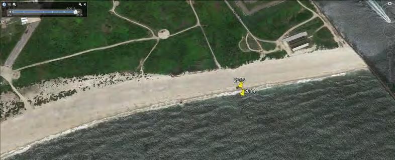
10 October 2014 June 2015
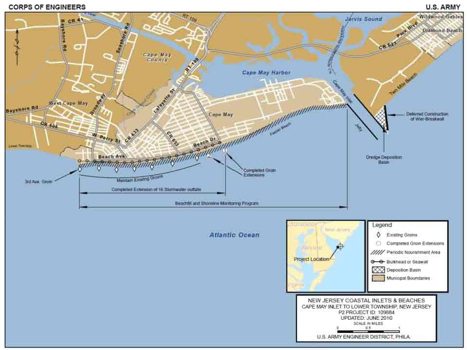
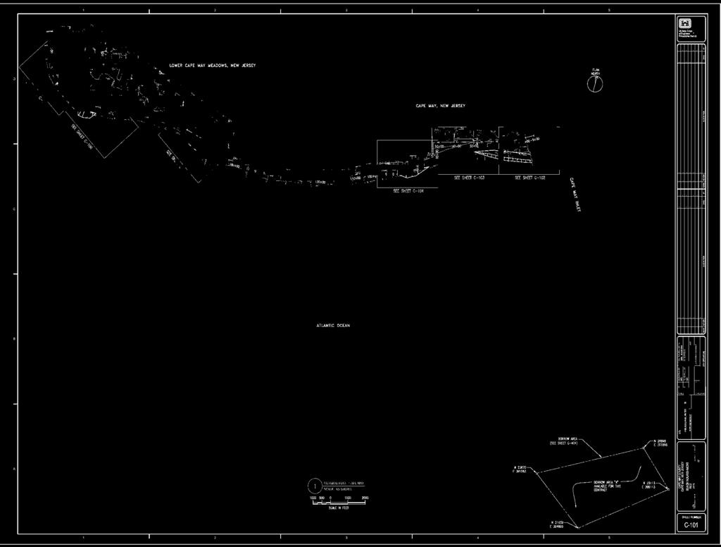
11 Cape May Inlet to Lower Township & Lower Cape May Meadows Cape May Point Cape May Inlet to Lower Township Overall Project Scope: Southwest jetty of Cape May Inlet to 3rd Ave. in Cape May City Phases to this Renourishment: Hydraulic Fill adjacent to southwest jetty USCG Base Wilmington Ave. (a.k.a. Poverty Beach) Lower Cape May Meadows Cape May Point Overall Project Scope: 3rd Ave. in Cape May City to Central Ave. in Cape May Point Phases to this Renourishment: Hydraulic Fill adjacent to southwest jetty Cove Beach TNC, CMPSP and CMP St. Pete s


12 Beach Nourishment Hydraulic Fill Hydraulic Fill Cape May Scope USCG: From Inlet Jetty to approximately 3,000 feet west of Jetty Poverty: Approximately 2,000 feet centered on Wilmington Ave. Cove: Approximately 1,700 feet Several Access Points throughout the project Pipeline landing To be determined Offshore borrow area approx miles southeast of inlet Berm width- 100 to 400-foot wide, at elevation feet NAVD88 (width varies based upon location and condition) Approximately 735,000 cubic yards of sand
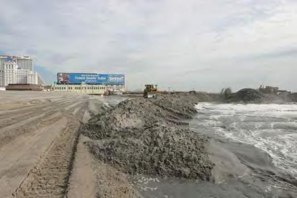
13 What To Expect Project Area - Dredge and associated water equipment Tugs, Barges, Pipeline (submerged and floating) crew boats Heavy Machinery/Pipeline - On Beach and In Water Bulldozers, Excavators, Pipe loaders, Dump shacks 24/7 Operation with continuous inspection Bright lights and backup beepers Screens on dredge intake and discharge pipeline To collect debris and potential munitions


14 Environmental Concerns Beach Nesting Birds/Sea Beach Amaranth Contract timeframe is out of typical season Conditions in specs to protect E&T species Archaeological Resources No significant or sensitive resources within or directly adjacent to borrow areas or project footprint Munitions/Debris Screened at Dredge Intake Screened at Discharge Pipe on the Beach
15 Post Project O & M Municipality s obligations Maintain and Operate Beaches/Dunes Consistent with State Aid Agreement Consistent with all other Federal, State and Local regulations Consistent with Coastal Zone Management Rules (NJAC 7:7) Regulatory Jurisdictional Federal Army Corps of Engineers Regulatory Section 408 State NJDEP Division of Land Use Regulation Coastal Zone Management Rules (NJAC 7:7)» Subchapter Standards for Beach and Dune Activities


16 Cape May Beachfill Public Info Session August 25, 2016 Dwight Pakan, Project Manager Civil Works Programs Branch
17 Philadelphia District Delaware River NY NJ New York City PA C&D Canal Philadelphia Wilmington Trenton Manasquan Inlet N MD Dover DE

18 Cape May Inlet to Lower Township, NJ CM Cape May County Wildwood Location Cape May Point Cape May City U.S. Coast Guard PA Philadelphia NJ Borrow Area MD DE Project Area
19
20 Cape May City Project Feeder beach concept (which is performing as designed) About 300K cy placed every 2 years at USCG Cape May city proper has needed minimal nourishment
21

 30 additional days for remainder of project Contract Completion")
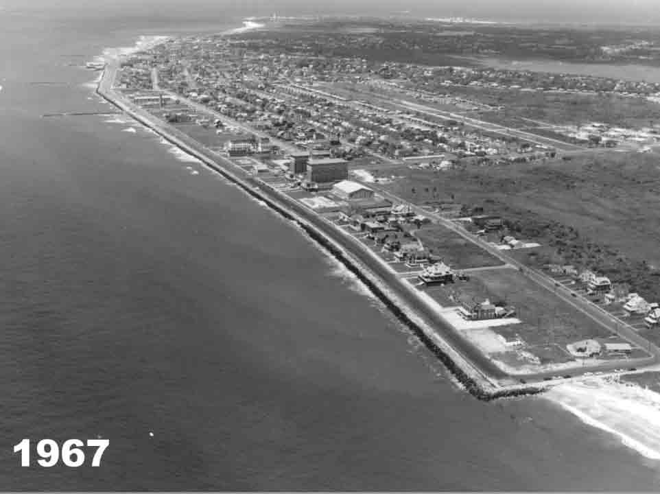
22 2016 Cape May Beach Nourishment Facts Bid Opening: 13-SEP-2016 Award: 27-SEP-2016 Notice to Proceed: 14-OCT-2016 Pre-Construction Meeting: 14-OCT-2016 Construction: 1-NOV-2016 Timeframe of Sand Pumping: 30 days (Cape May) 30 additional days for remainder of project Contract Completion Date: 1-MAR-2017

23
24
25
26

27 CAPE MAY INLET, NJ

28 Halloween 1991 Northeaster Cape May (view ENE)
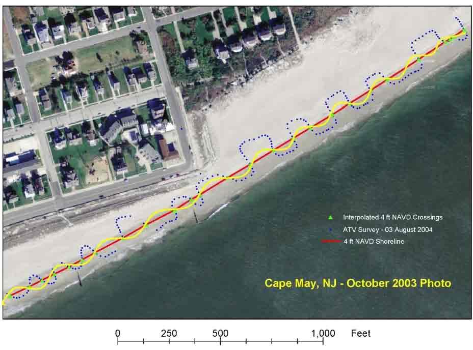
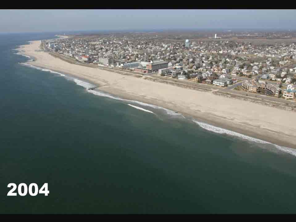
29 Typical Beachfill Cross Section Not to Scale Constructed Berm Existing Beach Advanced Nourishment High Tide
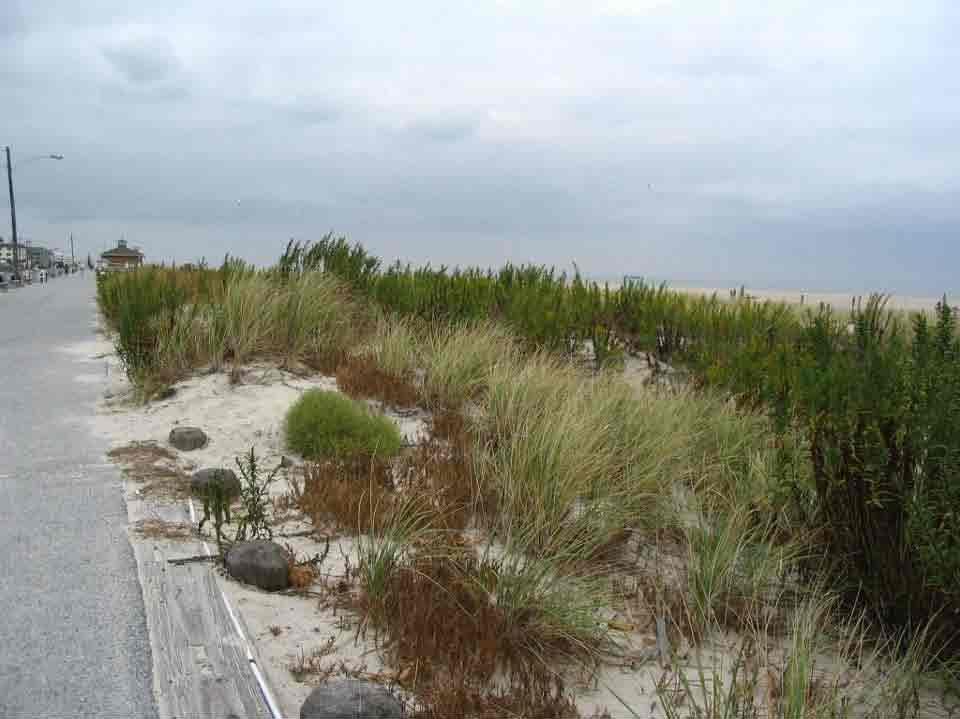
30 Cape May City Project Authorized for construction in WRDA 1986 Initial construction commenced 1989 and completed 1991 with 1.4M CY placed, and 17 outfalls and 2 groins extended 4M CY placed through 10 cycles of periodic nourishment Last Federal placement of sand (10 th nourishment) completed January ,000 CY 535,000 CY placed at USCG Base 50,000 CY placed at Wilmington Ave. 11 th cycle of periodic nourishment to start this Fall estimate 394K CY at USCG and 37K CY at Wilm Ave

31 Typical Beachfill Construction Method


32 Cape May Inlet to Lower Township Before After CM Photo
33
34

35 Baltimore Avenue 1978 vs 2009

36 Gurney Street 1978 vs 2009


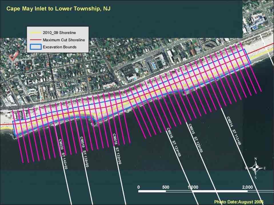
37 Cape May City Project Looking South - March 2004
38 Cape May City Project Proactive community dune program

39 Cape May City Dune Growth
40
41 Cape May Slope Demo 9 th cycle of periodic nourishment included beach slope demo project 70K CY excavated from Gurney St to Trenton Ave Remaining slope was flatter (1V:25H) Sand placed near Wilmington Ave Cost was over $1M Flat slope did not last more than a month (returned to 1V:12H) Side effect of excavation was rocky/pebbly beach
42
43
44 Borrow Areas Worldwide sand shortage (80% used for construction) Time-consuming process for ID/approval of sand source Analysis done to determine potential sites Geotechnical sand samples retrieved/analyzed Suitable sites identified Sites vetted thru agencies (NJ Land Use, Shellfish, Finfish, Endangered and Non-Game Species; Federal National Marine Fisheries, USFWS; Public) Approval takes years
45 Location of the four additional (current) Cape May Meadows borrow areas in the Cape May Meadows, New Jersey region.
46 Previously Identified Borrow Areas


47 New Jersey Department of Environmental Protection Shore Protection Program Glenn Golden Current State Project Manager Chris Constantino Past State Project Manager Contact:
New Jersey Dept. of Environmental Protection Shore Protection Program
 New Jersey Dept. of Environmental Protection William Dixon, Acting Manager 1510 Hooper Avenue, Suite 140 Toms River, New Jersey 08753 1-732-255-0767 New Jersey s State of New Jersey Chris Christie, Governor
New Jersey Dept. of Environmental Protection Shore Protection Program
 New Jersey Dept. of Environmental Protection Benjamin Keiser, Manager 1510 Hooper Avenue, Suite 140 Toms River, New Jersey 08753 1-732-255-0767 New Jersey s State of New Jersey Chris Christie, Governor
Dredging, Beach Nourishment and. Bird Conservation Workshop Atlantic Coast Region
 Dredging, Beach Nourishment and US Army Corps Bird Conservation Workshop Atlantic Coast Region Beach Nourishment and Bird Habitat Restoration in Southern New Jersey Shore Protection and Ecosystem Restoration
TABLE OF CONTENTS. Executive Summary 1 Acknowledgements 3 Introduction 3 Storm Recovery and Beach Project Effectiveness 3
 TABLE OF CONTENTS Executive Summary 1 Acknowledgements 3 Introduction 3 Storm Recovery and Beach Project Effectiveness 3 Monmouth County 4 Figures 1a-1d. Monmouth County Station Locations 5 Site Descriptions
Philadelphia District: Cape May County, New Jersey
 ERDC/RSM-DB6, June 2003 Regional Sediment Management (RSM) Demonstration Program Project Brief Philadelphia District: Cape May County, New Jersey ISSUE The Atlantic coast of New Jersey extends from Sandy
2012 STATUS REPORT NJ BEACHES AND INLETS PHILADELPHIA DISTRICT, USACE
 2012 STATUS REPORT NJ BEACHES AND INLETS PHILADELPHIA DISTRICT, USACE Jeff Gebert, Coastal Planning, USACE Philadelphia Philadelphia District Established 1866 Delaware River Basin Parts of 5 states 9 million
New Jersey Regional Sediment Management
 New Jersey Regional Sediment Management RSM Demo: Cape May Inlet / Wildwood Sand Bypassing Project Ocean County N Atlantic Ocean Atlantic County Delaware Bay Cape May County 8 0 8 16 Miles Regional Sediment
Corps Dredge Plan 2016 Emily Hughes Env Resources, USACE BUILDING STRONG
 Corps Dredge Plan 2016 Emily Hughes Env Resources, USACE Goodbye Jeff Richter!! Navigation/Operations USACE Goal/Mission: To maintain safe Navigation in Federal Channels using methods that are most (1)
Endangered Species Monitoring - Northern Coastline of New Jersey
 Endangered Species Monitoring - Northern Coastline of New Jersey By: Mark H. Burlas, Sr. Wildlife Biologist U.S. Army Corps of Engineers New York District Planning Division Presentation Format Project
U.S. Army Corps of Engineers Regulatory Program
 U.S. Army Corps of Engineers Regulatory Program Hull Offshore Wind Workshop Hull, Massachusetts 12 May 2011 Presented by: James W. Haggerty Regulatory Program Manager North Atlantic Division US Army Corps
Feasibility Study To Define Costs & General Conditions For Construction of Improved Entrance Structure
 Feasibility Study To Define Costs & General Conditions For Construction of Improved Entrance Structure From Lake Michigan Into Mona Lake Muskegon County, Michigan Muskegon Chronicle, August 2007 Prepared
Cat Island Chain Restoration Project Brown County Port & Resource Recovery Department
 Cat Island Chain Restoration Project Brown County Port & Resource Recovery Department February 2, 2015 Fox River and Lower Green Bay Cat Island Chain - 1938 Cat Island Brown County Aerial Photography,
CCMP Expert Workshops Preliminary Results and Next Steps
 Credit: Mark Houlday Lewes, DE Credit: Sandi Bisgood CCMP Expert Workshops Preliminary Results and Next Steps 2 Workshop Schedule Webinar: 11/7 Recording available online Healthy Waters (1): 11/17 DRBC;
1. Qualitative Assessment... II-101
 Table of Contents I. Introduction... I-1 A. Session Law 2009-479 / House Bill 709... I-2 B. Public Consultation... I-3 C. Selection of Study Sites... I-5 D. Limitations of Study... I-8 II. Physical Assessment...
Piping Plovers - An Endangered Beach Nesting Bird, and The Threat of Habitat Loss With. Predicted Sea Level Rise in Cape May County.
 Piping Plovers - An Endangered Beach Nesting Bird, and The Threat of Habitat Loss With Thomas Thorsen May 5 th, 2009 Predicted Sea Level Rise in Cape May County. Introduction and Background Piping Plovers
COASTAL MANAGEMENT ELEMENT
 COASTAL MANAGEMENT ELEMENT of the PINELLAS COUNTY COMPREHENSIVE PLAN Prepared By: The Pinellas County Planning Department as staff to the LOCAL PLANNING AGENCY for THE BOARD OF COUNTY COMMISSIONERS OF
Technical Memorandum ECO-7
 To: Woody Frossard, TRWD From: Bob Brashear, CDM This document is released for the purpose of interim review under the authority of Robert Brashear, P.E., TX license 80771 on 21-Mar-2005. It is not to
Collaboration and Planning to Implement the South San Diego Bay Restoration and Enhancement Project
 Collaboration and Planning to Implement the South San Diego Bay Restoration and Enhancement Project Carolyn Lieberman Coastal Program Coordinator for Southern California U.S. Fish and Wildlife Service
Wetland Restoration at Blackwater NWR. Dixie Birch November 2, 2006
 Wetland Restoration at Blackwater NWR Dixie Birch November 2, 2006 Goal: Restore 20,000 acres In Dorchester County including 11,000 at Blackwater Strategic Partnerships Remaining marsh shown in red Blackwater
HDD Wire Guided Waterway Crossing ATON Plan. Youghiogheny River (S122)
") HDD Wire Guided Waterway Crossing ATON Plan Youghiogheny River (S122) Mariner East Phase 2 Pipeline Project Prepared for: Sunoco Pipeline, L.P. 535 Friztown Road Sinking Springs, PA 19608 Prepared by:
HDD Wire Guided Waterway Crossing ATON Plan Youghiogheny River (S122) Mariner East Phase 2 Pipeline Project Prepared for: Sunoco Pipeline, L.P. 535 Friztown Road Sinking Springs, PA 19608 Prepared by:
Expansion Work Has Begun The perimeter dike for Cell 7 is now visible
 Summer/Fall 2017 In This Issue Poplar Island Expansion Wetland Cell 5AB Development Wildlife Update Birding tours on Poplar Island Expansion Work Has Begun The perimeter dike for Cell 7 is now visible
Facts about the DuPont Nature Center at Mispillion Harbor Reserve
 Facts about the DuPont Nature Center at Mispillion Harbor Reserve The Center: The DuPont Nature Center at Mispillion Harbor Reserve is a $2.1 million natural history interpretive center and wildlife observatory.
Ensuring habitat considerations in beach and shoreline management along Delaware Bay a bay wide perspective.
 Ensuring habitat considerations in beach and shoreline management along Delaware Bay a bay wide perspective. Kimberly B. Cole, David B. Carter, Tricia K. Arndt Delaware Coastal Programs Delaware Bay Coastal
Instruction with Hands-on Practice: Creating a Bathymetric Database & Datum Conversion
 Instruction with Hands-on Practice: Creating a Bathymetric Database & Datum Conversion Tanya Beck Coastal and Hydraulics Laboratory Engineer Research and Development Center May 17, 2010 US Army Corps of
APPENDIX A. SECTION 404(b)(1) EVALUATION
(1) EVALUATION") Draft Appendix A Section 404(b)(1) APPENDIX A SECTION 404(b)(1) EVALUATION TYBEE ISLAND, GEORGIA SHORELINE PROTECTION PROJECT 2019 HURRICAN HARVEY, IRMA, MARIA EMERGENCY SUPPLEMENTAL RENOURISHMENT U.S.
Draft Appendix A Section 404(b)(1) APPENDIX A SECTION 404(b)(1) EVALUATION TYBEE ISLAND, GEORGIA SHORELINE PROTECTION PROJECT 2019 HURRICAN HARVEY, IRMA, MARIA EMERGENCY SUPPLEMENTAL RENOURISHMENT U.S.
Rookery Island Clean Ups Remove 8,000 Pounds of Trash and Debris by Kathryn Tunnell
 Stay connected with The Edge: News and Updates from the Coastal Bend Bays & Estuaries Program News and Updates from the Coastal Bend Bays & Estuaries Program Visit Our Website Rookery Island Clean Ups
Distribution of Piping Plover and Coastal Birds in Relation to Federal Activities on the Southern Coast of Long Island
 U.S. U.S. Fish Fish & Wildlife & Wildlife Service Service Distribution of Piping Plover and Coastal Birds in Relation to Federal Activities on the Southern Coast of Long Island Implications for Project
RESTORE Act Bucket 2 Planning Public Meeting
 RESTORE Act Bucket 2 Planning Public Meeting James C. Gibeaut, Ph.D. Coastal and Marine Geospatial Sciences Harte Research Institute for Gulf of Mexico Studies Texas A&M University Corpus Christi Public
City of Cape May Master Plan Reexamination. Open House - April 16, 2018
 City of Cape May Master Plan Reexamination Open House - April 16, 2018 2 What is a Master Plan Vision for the municipality Provides direction and guidance for the growth, resource preservation, and land
BookletChart. Sacramento River Andrus Island to Sacramento NOAA Chart A reduced-scale NOAA nautical chart for small boaters
 BookletChart Sacramento River Andrus Island to Sacramento NOAA Chart 18662 A reduced-scale NOAA nautical chart for small boaters When possible, use the full-size NOAA chart for navigation. Included Area
Soft Engineering Case Study: Wallasea Island
 Soft Engineering Case Study: Wallasea Island Situation By the British Geographer Wallasea Island is on the south side of the Crouch Estuary in Essex and also linked to the Roach Estuary. These estuaries
Report on Wintering Western Snowy Plovers at Coos Bay North Spit and Impacts to Plovers from The North Jetty Repair Project, Winter 2009
 Report on Wintering Western Snowy Plovers at Coos Bay North Spit and Impacts to Plovers from The North Jetty Repair Project, Winter 2009 David J. Lauten, Kathleen A. Castelein, and Eleanor P. Gaines The
UPPER MISSISSIPPI RIVER RESTORATION LAKE ODESSA HABITAT REHABILITATION AND ENHANCEMENT PROJECT OPERATION AND MAINTENANCE MANUAL APPENDIX F
 UPPER MISSISSIPPI RIVER RESTORATION LAKE ODESSA HABITAT REHABILITATION AND ENHANCEMENT PROJECT OPERATION AND MAINTENANCE MANUAL APPENDIX F PROJECT PHOTOGRAPHS Table of Photographs Photograph 1: Lake Odessa
United States Department of the Interior
 United States Department of the Interior Mickey T. Sugg Wilmington Regulatory Field Office U. S. Army Corps of Engineers 69 Darlington Ave. Wilmington, North Carolina 28403 FISH AND WILDLIFE SERVICE Raleigh
Central California. 600,000 breeding seabirds + 8 million people (SF Bay Area) Potential for disturbance is high!
 Potential for disturbance is high!") Central California 600,000 breeding seabirds + 8 million people (SF Bay Area) -------------------------- Potential for disturbance is high! Overview Seabird Protection Network 2010 Accomplishments Expanding
Central California 600,000 breeding seabirds + 8 million people (SF Bay Area) -------------------------- Potential for disturbance is high! Overview Seabird Protection Network 2010 Accomplishments Expanding
NORTH CAROLINA STATEWIDE PROGRAMMATIC BIOLOGICAL OPINION BEACH SAND PLACEMENT EXECUTIVE SUMMARY August 28, 2017
 INTRODUCTION NORTH CAROLINA STATEWIDE PROGRAMMATIC BIOLOGICAL OPINION BEACH SAND PLACEMENT EXECUTIVE SUMMARY August 28, 2017 A biological opinion (BO) is the document that states the opinion of the U.S.
Marine Corps Support Facility-Blount Island: Integrated Natural Resources Program Successes. E2S2 Conference May 12, 2011
 Marine Corps Support Facility-Blount Island: Integrated Natural Resources Program Successes E2S2 Conference May 12, 2011 Shari Kennedy, MCSF-BI Robert Price, CH2M HILL Location Mission The mission of Marine
Roberts Bank Terminal 2 Project Field Studies Information Sheet
 May 2013 Port Metro Vancouver is continuing field studies in May as part of ongoing environmental and technical work for the proposed Roberts Bank Terminal 2 Project. Roberts Bank Terminal 2 Project The
Site Description: Gull Rock is located approximately 0.4 miles offshore and about six miles north of Yaquina Head in Lincoln County, Oregon.
 Devil s Punchbowl intertidal area Gull Rock (offshore) 12. Gull Rock Site Description: Gull Rock is located approximately 0.4 miles offshore and about six miles north of Yaquina Head in Lincoln County,
Management Unit 2: East Beach to West Beach, Selsey
 Management Unit 2: East Beach to West Beach, Selsey Unit limits 4400m from 487200E, 094300N to 484450E, 093100N This Unit also forms Unit 1 of the South Downs SMP. Coastal processes The Selsey peninsula,
Lake Worth Lagoon Initiative Habitat Working Group
 Lake Worth Lagoon Initiative Habitat Working Group April 5, 2018 10:00am 12:00pm AGENDA I. Introductions II. Business A. LWL Benthic Analysis at Fixed Transect Locations Cheryl Miller, Coastal Eco-Group
Economic Values Generated by the New Jersey Shore for Climate Change and Coastal Hazards Conference
 Economic Values Generated by the New Jersey Shore for Climate Change and Coastal Hazards Conference Professor Joseph J. Seneca Bloustein School of Planning and Public Policy, Rutgers University 25 May
COOK INLET NAVIGATION CHANNEL
 COOK INLET NAVIGATION CHANNEL 1-5 COOK INLET NAVIGATION CHANNEL, ALASKA (CWIS NO. 10324, 10534) Condition of Improvement 30 September 2011 AUTHORIZATION: (1) Water Resources Development Act of 1996 (Public
Northeast Florida Coastal Wetland Restoration Program A Partnership Based Regional Approach for Estuary Habitat Restoration
 Northeast Florida Coastal Wetland Restoration Program A Partnership Based Regional Approach for Estuary Habitat Restoration Paul Haydt Restore America s Estuaries November 15, 2010 St Johns River Water
SECTION DEWATERING TANKAGE PART 1 - GENERAL 1.1 RELATED DOCUMENTS
 SECTION 31 23 19 - DEWATERING TANKAGE PART 1 - GENERAL 1.1 RELATED DOCUMENTS A. Drawings and general provisions of the Contract, including General and Supplementary Conditions and Division 1 Specification
Dare County DEIS Position Statement
 Dare County DEIS Position Statement SUMMARY The Dare County Board of Commissioners strongly supports open and accessible beaches for the Cape Hatteras National Seashore Recreational Area. We believe in
U.S Army Corps Of Engineers ENG 4345 Permit Application Video Script Feb- 10
 U.S Army Corps Of Engineers ENG 4345 Permit Application Video Script - 03- Feb- 10 TRANSCRIPT Hi there, I'm Debra and welcome to the US Army Corps of Engineers permit application video. The purpose of
MINUTES OF MEETING BOARD OF COUNTY COMMISSIONERS ST. JOHNS COUNTY, FLORIDA MAY 1, :00 A.M.
 MINUTES OF MEETING BOARD OF COUNTY COMMISSIONERS ST. JOHNS COUNTY, FLORIDA MAY 1, 2017 9:00 A.M. Proceedings of a joint meeting of the Board of County Commissioners (BCC) of St. Johns County, Florida,
Beach Nourishment in Galveston, Texas A Long Term Plan For Success
 Beach Nourishment in Galveston, Texas A Long Term Plan For Success Reuben Trevino, Director of Operations Galveston Island Park Board of Trustees Parks & Natural Areas (PNA) Sub-Committee Natural Resources
PRESENTATION TITLE. Regional Sediment Management. Common goals for uncommon results. AAPA Facilities Engineering Seminar October 22, 2015
 Regional Sediment Management PRESENTATION TITLE Common goals for uncommon results AAPA Facilities Engineering Seminar October 22, 2015 Presented by: Milan A. Mora, PE Project Manager Water Resources Branch
Old House Channel Bathymetric and Side Scan Survey
 FIELD RESEARCH FACILITY DUCK, NC Old House Channel Bathymetric and Side Scan Survey COASTAL AND HYDRAULICS LABORATORY FIELD DATA COLLECTION AND ANALYSIS BRANCH Michael Forte December 2009 View looking
Rocky Reach Wildlife Forum 2017 Wildlife Monitoring Proposal FINAL
 Rocky Reach Wildlife Forum 2017 Wildlife Monitoring Proposal FINAL Background January 13, 2017 During the Rocky Reach Hydroelectric Project (Project 2145) relicensing process, the Public Utility District
LESSONS FROM HURRICANE FLORENCE: TOOLS TO PROTECT BIRDS AND PEOPLE October 14, 2018
 LESSONS FROM HURRICANE FLORENCE: TOOLS TO PROTECT BIRDS AND PEOPLE October 14, 2018 One month ago, the Coastal Carolinas experienced firsthand the widespread impacts of Hurricane Florence. For birds and
SURVEY OF SEAGRASS BEDS AT PLACEMENT AREA 62, WEST BAY CONTRACT FOR GIWW, TEXAS CAUSEWAY U. S. ARMY CORPS OF ENGINEERS CONTRACT NO.
 SURVEY OF SEAGRASS BEDS AT PLACEMENT AREA 62, WEST BAY CONTRACT FOR GIWW, TEXAS CAUSEWAY U. S. ARMY CORPS OF ENGINEERS CONTRACT NO. W912HY-10-C-0036 Prepared for: RLB CONTRACTING, INC. P.O. Box 1739 Port
Lakes and Rivers Division, David Dale
 Locks and Dams 2, 3, and 4 Monongahela River, PA (Lower Mon Project) Inland Waterways Users Board Lakes and Rivers Division, David Dale November 2014 David Dale, PE, PMP Braddock Dam US Army Corps of Engineers
APPENDIX M BIRD NESTING DATA ( )
") APPENDIX M BIRD NESTING DATA (1984-2011) Final Environmental Impact Statement Village of Bald Head Island Shoreline Protection Project Brunswick County, North Carolina Date Species Number of Birds Number
APPENDIX M BIRD NESTING DATA (1984-2011) Final Environmental Impact Statement Village of Bald Head Island Shoreline Protection Project Brunswick County, North Carolina Date Species Number of Birds Number
Piping Plover Nesting Results in New Jersey: 2017
 Piping Plover Nesting Results in New Jersey: 2017 Prepared by Emily Heiser, Wildlife Biologist Conserve Wildlife Foundation of New Jersey and Christina Davis, Environmental Specialist II New Jersey Division
APPENDIX K US FISH AND WILDLIFE SERVICE FINAL COORDINATION ACT REPORT
 FINAL INTEGRATED FEASIBILITY REPORT AND ENVIRONMENTAL IMPACT STATEMENT COASTAL STORM DAMAGE REDUCTION BOGUE BANKS, CARTERET COUNTY NORTH CAROLINA APPENDIX K US FISH AND WILDLIFE SERVICE FINAL COORDINATION
Sector Delaware Bay/District 5NR - Coast Guard Auxiliary Patrol Areas. Eastern Area
 Enclosure (2) to SECDELBAYINST 16790.1F Sector Delaware Bay/District 5NR - Coast Guard Auxiliary Patrol Areas STA Manasquan Inlet: (Div 16) Eastern Area Station (Small) Shark River: AREA 1 Shark River
Richard A. Fischer, Ph.D. U.S. Army Engineer Research and Development Center Environmental Laboratory
 Regional Sediment Management - Beneficial Uses of Dredged Material Along Lake Erie and Tributaries Section 204 of the 1992 Water Resources Development Act Richard A. Fischer, Ph.D. U.S. Army Engineer Research
Annex C. DEA Pre-Application Meeting Records
 Annex C DEA Pre-Application Meeting Records IOX Submarine Cable System Environmental Impact Assessment Pre-Application Meeting South Africa Department of Environmental Affairs 30 May 2018 Insert then
Humboldt Bay Piling Removal
 REQUEST FOR PROPOSALS Humboldt Bay Piling Removal Invitation for Proposals The Humboldt Bay Harbor, Recreation & Conservation District (District) is requesting proposals from qualified individuals/firms
Proposed Anchorage Grounds, Hudson River; Yonkers, NY to Kingston, NY Docket Number USCG
 August 8, 2016 U.S. Coast Guard First District C/O Mr. Craig Lapiejko Waterways Management Branch Submitted Via Federal erulemaking Portal Subject: Proposed Anchorage Grounds, Hudson River; Yonkers, NY
Money Bayou Outfall Relocation Project
 Permit Sketches and General Notes Money Bayou Outfall Relocation Project 76 & 768 State Road (SR) Port St. Joe, Florida 2456 Section 9, Township 9S, Range W Gulf County, Florida 29 4.8' N, 85 7.2' W APPLICANT
15 November 1969: Prior to Baptiste Collette channel construction
 DREDGED MATERIAL DISPOSAL HISTORY Baptiste Collette Bayou existed as a small canal in 1868 that extended between the Mississippi River and what was then known as the Bird Island Sound. In 1874, a crevasse
Annual Report. Estuary Conservation Association. January 2014
 Annual Report 2013 Estuary Conservation Association Encouraging environmental stewardship for the Cocohatchee estuary that fosters a balance of nature and community through science, education, safe navigation
A. Dewatering observation wells are part of dewatering allowance.
 SECTION 312319 - DEWATERING PART 1 - GENERAL 1.1 RELATED DOCUMENTS A. Drawings and general provisions of the Contract, including General and Supplementary Conditions and Division 01 Specification Sections,
Coastal Virginia Offshore Wind partnership with Orsted. February 2018 Update
 Coastal Virginia Offshore Wind partnership with Orsted February 2018 Update 1 Coastal Virginia Offshore Wind Project: Lease Update Research and Commercial Lease Areas Phase 1 CVOW Lease Area (2,135 acres)
Goal: Effective Decision Making
 Goal: Effective Decision Making Objective 1. Enhance inter-agency coordination Focus on aspects of governmental decision-making (NEPA and other existing siting/regulatory programs) related to marine energy
SECTION DEWATERING PART 1 - GENERAL 1.1 RELATED DOCUMENTS
 SECTION 312319 - DEWATERING PART 1 - GENERAL 1.1 RELATED DOCUMENTS A. Drawings and general provisions of the Contract, including General and Supplementary Conditions and Division 01 Specification Sections,
New Jersey Coastal Zone Management Act Consistency Statement
 1.0 Project Background New Jersey Coastal Zone Management Act Consistency Statement A Coastal Zone Management Act Consistency Statement was prepared as part of the 2000 Environmental Impact Statement (EIS)
A B C D E F G H SEE NOTE 1 EL (MIN.) 2 NEW UNCOMPACTED EL. VARIES EARTH EMBANKMENT 3 (MIN.) TYPICAL SECTION EMBANKMENT AND BORROW 6 (MIN.
 2 NEW UNCOMPACTED EL. VARIES EARTH EMBANKMENT 3 (MIN.) TYPICAL SECTION EMBANKMENT AND BORROW 6 (MIN.") BORROW AS NECESSARY TO CONSTRUCT RIVERWARD SEE NOTE EL.. (MIN.) (MIN.) NEW UNCOMPACTED EL. EARTH C L C C C TYPICAL SECTION AND BORROW NO SCALE. CDF FLAT POOL EL.. JULJRP/REH AS CONSTRUCTED Approved Description
BORROW AS NECESSARY TO CONSTRUCT RIVERWARD SEE NOTE EL.. (MIN.) (MIN.) NEW UNCOMPACTED EL. EARTH C L C C C TYPICAL SECTION AND BORROW NO SCALE. CDF FLAT POOL EL.. JULJRP/REH AS CONSTRUCTED Approved Description
MLG to MLLW Vertical Datum Conversion. Mississippi River Venice, Louisiana to the Gulf of Mexico (Vicinity of Southwest Pass) Louisiana
 Louisiana") Engineering Documentation Report EDR-OD-01 MLG to MLLW Vertical Datum Conversion Mississippi River Venice, Louisiana to the Gulf of Mexico (Vicinity of Southwest Pass) Louisiana Prepared by: US Army Corps
Engineering Documentation Report EDR-OD-01 MLG to MLLW Vertical Datum Conversion Mississippi River Venice, Louisiana to the Gulf of Mexico (Vicinity of Southwest Pass) Louisiana Prepared by: US Army Corps
Emerging Subsea Networks
 FIBRE-TO-PLATFORM CONNECTIVITY, WORKING IN THE 500m ZONE Andrew Lloyd (Global Marine Systems Limited) Email: andrew.lloyd@globalmarinesystems.com Global Marine Systems Ltd, New Saxon House, 1 Winsford
SENATE CONCURRENT RESOLUTION No. 158 STATE OF NEW JERSEY. 217th LEGISLATURE INTRODUCED JUNE 26, 2017
 SENATE CONCURRENT RESOLUTION No. STATE OF NEW JERSEY th LEGISLATURE INTRODUCED JUNE, 0 Sponsored by: Senator JEFF VAN DREW District (Atlantic, Cape May and Cumberland) Senator ROBERT M. GORDON District
NOTICE OF REGULARLY SCHEDULED BOARD MEETINGS
 NOTICE OF REGULARLY SCHEDULED BOARD MEETINGS NEW JERSEY TRANSIT CORPORATION NJ TRANSIT RAIL OPERATIONS, INC. NJ TRANSIT BUS OPERATIONS, INC. NJ TRANSIT MERCER, INC. NJ TRANSIT MORRIS, INC. TO WHOM IT MAY
Roberts Bank Terminal 2 Project Field Studies Information Sheet
 January 2013 Port Metro Vancouver is continuing field studies in January as part of ongoing environmental and technical work for the proposed. The is a proposed new multi berth container terminal which
LAKE HOPATCONG. Lake Hopatcong, New Jersey
 LAKE HOPATCONG Lake Hopatcong, New Jersey Presentation to NEIWPCC May 20, 2008 by Ken Klipstein, Director NJWSA Watershed Protection Unit and Pat Rector, NJDEP Div. Watershed Management LAKE HOPATCONG
REVISED DRAFT Integrated Hurricane Sandy General Reevaluation Report and Environmental Impact Statement. Atlantic Coast of New York
 REVISED DRAFT Integrated Hurricane Sandy General Reevaluation Report and Environmental Impact Statement Atlantic Coast of New York East Rockaway Inlet to Rockaway Inlet and Jamaica Bay Appendix D Environmental
2003 New Jersey Endangered Beach Nesting Bird (Piping Plover, Least Tern and Black Skimmer) Site Management Report
 Site Management Report") 2003 New Jersey Endangered Beach Nesting Bird (Piping Plover, Least Tern and Black Skimmer) Site Report Prepared By C. David Jenkins, Principal Zoologist Todd Pover, Biological Assistant New Jersey Department
2003 New Jersey Endangered Beach Nesting Bird (Piping Plover, Least Tern and Black Skimmer) Site Report Prepared By C. David Jenkins, Principal Zoologist Todd Pover, Biological Assistant New Jersey Department
1. Working with Bathymetry
 1. Working with Bathymetry The CMS setup for Shark River Inlet provides a succinct example for illustrating a number of methods and SMS tools that can be applied to most engineering projects. The area
Spring-Summer Issue 66. The Great Egg Harbor Watershed Association s website has a new look. Check us out.
 Spring-Summer 2015 www.gehwa.org Issue 66 The Great Egg Harbor Watershed Association s website has a new look. Check us out. National Park Foundation 2014 Impact Grant In 2014 the National Park Foundation,
Results of Nesting Bird Survey in Support of Fiscalini Ranch Forest Test Plots, Cambria, California
 May 26, 2016 Carlos Mendoza Cambria Community Services District 1316 Tamsen Drive, Suite 201 Cambria, California 93428 RE: Results of Nesting Bird Survey in Support of Fiscalini Ranch Forest Test Plots,
New Jersey PRESERVING OUR WATERFOWLING TRADITION THROUGH HABITAT CONSERVATION!
 New Jersey PRESERVING OUR WATERFOWLING TRADITION THROUGH HABITAT CONSERVATION! he Delaware Bay and the New York Bight watersheds provide a multitude of critical wetland and upland habitats for fish and
Geographic Response Plan Map: SC-56. Map Continued on SC-50 XXX. Fripps Inlet. Raptor Nesting Area. Recreational Fishing. Sea Turtles.
 32 22'30"N Map Continued on SC-55 80 30'0"W X ull et SC56-01 Story/Harbor River Junction Story River!h!S(!d Old House Creek 1050 [ 400 1000 SC56-03 Old House Creek «Geographic Response Plan Map: SC-56
A Rising Tide: Conserving Shorebirds and Shorebird Habitat within the Columbia River Estuary
 A Rising Tide: Conserving Shorebirds and Shorebird Habitat within the Columbia River Estuary By Vanessa Loverti USFWS Migratory Birds and Habitat Programs, Portland, Oregon May 28, 2014 Outline of Talk
GCG ASSOCIATES, INC. February 8, Mr. Nathaniel Strosberg, Town Planner 101 Main Street Town of Ashland Ashland, MA 01721
 GCG ASSOCIATES, INC. CIVIL ENGINEERING AND LAND SURVEYING 84 Main Street Wilmington, Massachusetts 01887 Phone: (978) 657-9714 Fax: (978) 657-7915 February 8, 2016 Mr. Nathaniel Strosberg, Town Planner
Oil Spill Funds and the Opportunities they Present for Galveston Bay
 Oil Spill Funds and the Opportunities they Present for Galveston Bay A presentation to Texas Environmental Grantmakers Group By Bob Stokes, President, Galveston Bay Foundation Friday, October 31, 2014
ASSEMBLY JOINT RESOLUTION No. 48 STATE OF NEW JERSEY. 218th LEGISLATURE INTRODUCED JANUARY 29, 2018
 ASSEMBLY JOINT RESOLUTION No. STATE OF NEW JERSEY th LEGISLATURE INTRODUCED JANUARY, 0 Sponsored by: Assemblywoman DIANNE C. GOVE District (Atlantic, Burlington Ocean) Assemblyman BRIAN E. RUMPF District
Sanderling. Appendix A: Birds. Calidris alba. New Hampshire Wildlife Action Plan Appendix A Birds-67
 Sanderling Calidris alba Federal Listing State Listing Global Rank State Rank Regional Status N/A N/A G5 SNR High Photo by Pamela Hunt Justification (Reason for Concern in NH) Populations of several migratory
DOWNLOAD OR READ : NEW JERSEY WILDLIFE VIEWING GUIDE WILDLIFE VIEWING GUIDES SERIES PDF EBOOK EPUB MOBI
 DOWNLOAD OR READ : NEW JERSEY WILDLIFE VIEWING GUIDE WILDLIFE VIEWING GUIDES SERIES PDF EBOOK EPUB MOBI Page 1 Page 2 new jersey wildlife viewing guide wildlife viewing guides series new jersey wildlife
Alternative Technologies in Beach Preservation
 Alternative Technologies in Beach Preservation Proceedings of the 7th National Conference on Beach Preservation Technology Hyatt Regency Hotel Tampa, Florida February 9-11,1994 Conference Organizers: Florida
Chesapeake Bay adaptation Designing marshes for David Curson, National Audubon Society Erik Meyers, The Conservation Fund
 Chesapeake Bay adaptation Designing marshes for 2100 David Curson, National Audubon Society Erik Meyers, The Conservation Fund Blackwater National Wildlife Refuge Maryland s Everglades Biological Resources:
INGESTION OF JALBTCX ALB DATASET INTO NOAA'S CHART PRODUCTION
 INGESTION OF JALBTCX ALB DATASET INTO NOAA'S CHART PRODUCTION Shachak Pe eri (JHC/CCOM) and Gretchen Imahori (NOAA) OCS/MCD (NOAA): John Barber, Anthony Klemm, Julia Powell, Mike Brown and John Nyberg
Eastern Lake Ontario Dunes D-3 Assessment SLELO-PRISM Buckthorn and Swallow-wort Surveillance/Dune Willow Monitoring
 St. Lawrence Eastern Lake Ontario Partnership for Regional Invasive Species Management Eastern Lake Ontario Dunes D-3 Assessment Buckthorn and Swallow-wort Surveillance/Dune Willow Monitoring July 13 &
Technology and Equipment Working Group version 1 2
 MAYOR S WIND FARM COMMITTEE Working Group Summary : Technology and Equipment Working Group Members: Deanna Dworak, Kevin Glynn, Kristin Landry, Tim Patton May 2011 A. SUMMARY The Technology and Equipment
OIL AND GAS ACTIVITY IN THE GULF OF MEXICO FEDERAL OCS FROM 1990 THROUGH DECEMBER 31, 1998
 OIL AND GAS ACTIVITY IN THE GULF OF MEXICO FEDERAL OCS FROM 1990 THROUGH DECEMBER 31, 1998 J. Michael Melancon Department of the Interior Minerals Management Service Gulf of Mexico OCS Region ABSTRACT
October 21, 2010 Gregory Scott California State Lands Commission
 October 21, 2010 Gregory Scott California State Lands Commission 1 California State Lands Commission Background Established in 1938 by passage of the State Lands Act Authority: Div. 6 or the California
Environmental Stewardship
 Environmental Stewardship Jeff Wingfield Director of Environmental and Public Affairs 1 Environmental Enhancement Antioch Dunes Restoration 2 Dunes History Glacial sand deposits along San Joaquin River
BookletChart. Chesapeake Bay Pocomoke and Tangier Sounds NOAA Chart A reduced-scale NOAA nautical chart for small boaters
 BookletChart Chesapeake Bay Pocomoke and Tangier Sounds NOAA Chart 12228 A reduced-scale NOAA nautical chart for small boaters When possible, use the full-size NOAA chart for navigation. Published by the