Current Water Quality Conditions and Initial Documentation of Hydrilla (Hydrilla verticillata) in Harveys Lake, Luzerne County, PA
|
|
|
- Augustine Harrington
- 5 years ago
- Views:
Transcription
1 Current Water Quality Conditions and Initial Documentation of Hydrilla (Hydrilla verticillata) in Harveys Lake, Luzerne County, PA New York State Federation of Lake Associations 4 th 5 th May 2018 Fred S. Lubnow, Ph.D., and Michael Hartshorne Princeton Hydro, LLC 203 Exton Commons Exton, PA flubnow@princetonhydro.com mhartshorne@princetonhydro.com


2 Harveys Lake, Luzerne County, PA

3 Harveys Lake, Luzerne County, PA Largest natural lake, by volume, entirely located in Pennsylvania. Surface area: acres Watershed area: 3,627 acres Mean depth: 36 ft Maximum depth: 96 ft The lake and a portion of Harveys Creek, just below the outlet, are designed as cold water high quality water resources.
4 Annual TP in kg The Total Maximum Daily Load (TMDL) Approach (Harveys Lake, PA) Difference of 229 lbs Existing TP Load Targeted TP Load
5 Harveys Lake Projects Implemented to Date Implemented Stormwater or In-Lake Project Total Phosphorus Removed in kgs (lbs) Two streambank / shoreline stabilization projects 10.0 (22) Hemlock Garden Nutrient Separating Baffle Box 13.6 (30) Series of small, catch basin retrofits 6.1 (13.4) Wood Street Nutrient Separating Baffle Box 3.0 (6.6) Old Lake Road Nutrient Separating Baffle Box 3.0 (6.6) Floating Wetland Islands (Five); (50) Large Nutrient Separating Baffle Box system (PA F&BC); early (53) TOTAL 82.5 (181.6) By the end of 2020, the TMDL should be in compliance for total phosphorus

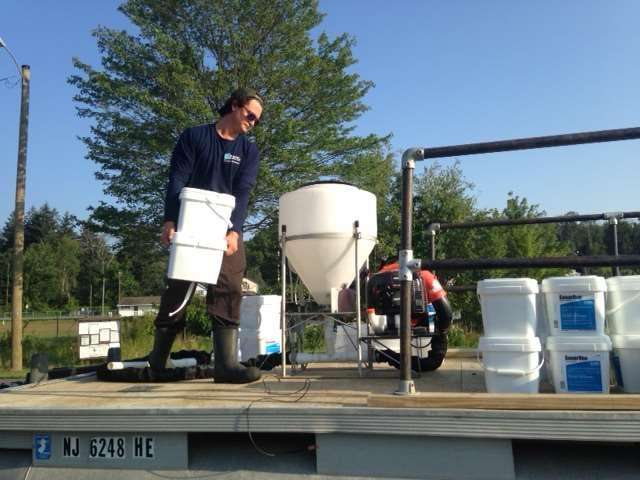
6 Nutrient Separating Baffle Box with Water Polishing Unit MTD


7 Installation of 3-Chambered Baffle Box at Wood Street in December 2011

8 Installation of 3-Chambered Baffle Box at Old Lake Road completed in September 2013

9 PA F&BC Boat Launch Stormwater Project (2016)

10 PA F&BC Boat Launch Stormwater Project (2017)

11 PA F&BC Boat Launch Riparian Buffer (2017)
 in")
12 Installation of five Floating Wetland Islands (FWIs) in 2014

13 Supplemental Planting in 2015

14 August 2017


15 Plants of Concern at Harveys Lake Grassy (variable) pondweed Vasey s pondweed

16 2012 SAV Survey Locations
17 2012 SAV Results Harveys Lake - Botanical Survey - 26 June 2012 Station Lat Long Secchi Common Scientific Abundance Sediments (m) n/a n/a n/a Rocky Grassy pondweed Potamogeton gramineus Abundant Large-leaf pondweed Potamogeton amplifolius Common Rocky Coontail Ceratophyllum demersum Present Eurasian watermilfoil Myriophyllum spicatum Abundant Grassy pondweed Potamogeton gramineus Common Large-leaf pondweed Potamogeton amplifolius Present Coontail Ceratophyllum demersum Present Rocky Elodea Elodea canadensis Common Small pondweed Potamogeton pusillus Present Tape grass Vallisneria americana Present Quillwort Isoetes sp. Common Grassy pondweed Potamogeton gramineus Common Rocky Small pondweed Potamogeton pusillus Common Large-leaf pondweed Potamogeton amplifolius Common Grassy pondweed Potamogeton gramineus Common Elodea Elodea canadensis Common Large-leaf pondweed Potamogeton amplifolius Common Grassy pondweed Potamogeton gramineus Common Eurasian watermilfoil Myriophyllum spicatum Common Tape grass Vallisneria americana Common Ornamental Lily Nymphaea sp. Present Large-leaf pondweed Potamogeton amplifolius Present Coontail Ceratophyllum demersum Present Elodea Elodea canadensis Present Eurasian watermilfoil Myriophyllum spicatum Common Tape grass Vallisneria americana Common Large-leaf pondweed Potamogeton amplifolius Common Grassy pondweed Potamogeton gramineus Present Elodea Elodea canadensis Abundant Eurasian watermilfoil Myriophyllum spicatum Common Clasping-leaf pondweed Potamogeton perfoliatus Present Elodea Elodea canadensis Abundant Coontail Ceratophyllum demersum Present Eurasian watermilfoil Myriophyllum spicatum Present Tape grass Vallisneria americana Common Eurasian watermilfoil Myriophyllum spicatum Common Rocky Rocky Compacted organics Rocky Rocky Rocky/gravel 11 Compacted organics
18 2012 Survey SAV community was comprised of several native Potamogetons, coontail, elodea and tape grass. Invasives consisted of Eurasian watermilfoil and ornamental lilies State T&E Grassy pondweed was found at 6 of the 11 transects. No hydrilla was noted during this survey

19

20

21 Hydrilla Found! July 16, 2014 Hydrilla identified during standard water quality monitoring

22 SAV Survey - September 4-5, 2014 Phase I
23 SAV Results 20 Species identified; Twice number as in 2012 Grassy pondweed found in 10 of the 13 transects Vasey s pondweed found in 2 of the 13 transects
24 SAV Results Three exotics present Eurasian watermilfoil at 8 of the 13 transects Ornamental lily throughout shoreline Hydrilla at 5 of the 13 transects All instances in Northern end of lake Heaviest infestation where major boat launch is located

25 Diving Survey Sept , 2014 Phase II
26 Diving Survey Sept , 2014 Phase II
27 Hydrilla Eradication Plan Princeton Hydro teamed with the SePRO Corporation to develop a fluridone based treatment regiment. Utilize Sonar PR and Sonar H4C at tailored dosages to eradicate hydrilla while minimizing impacts to non-target species Total area of treatment is estimated to be approximately 49 acres (three targeted areas)
28 Moving forward with the Plan Representatives from SePRO joined Princeton Hydro during its spring water quality monitoring event at Harveys Lake (April 2015) to obtain some more sitespecific information for the development of the treatment program and associated costs. Submitted a Growing Greener grant application for the treatment and monitor the eradication program
29 Notes on the General Ecology of Hydrilla in Harveys Lake Was not identified in the lake in 2012 but was identified in More than likely, it came in from a boat with a fragment of the plant on the boat or trailer. Limited to the northern end of the lake, away from the outlet of the lake.
30 Notes on the General Ecology of Hydrilla in Harveys Lake Hydrilla was found in 38% of the transect locations Hydrilla was found in waters as shallow as 2 feet but tended to be most abundant in depths of 4 feet and greater and dominant in waters deeper than feet. Hydrilla is known to grow in waters as deep as 20 ft but was found in Harveys Lake as deep as 25 ft
31 Notes on the General Ecology of Hydrilla in Harveys Lake Extremely high growth rate but limited to the northern end and the moderate to deeper waters of Harveys Lake. In PA it is fairly abundant in scattered sites in the Delaware and Schuylkill Rivers. It has been identified in the Chesapeake Bay and some of its lower tributaries According to PA Sea Grant, it has been sighted in the Susquehanna River Basin.
32 Impacts of Hydrilla Can outcompete other native plants for space and light (can grow approx. an inch a day) Clog boat propellers and negatively impact boating Has been known to enhance bass fishing in shallow lakes in Florida However, can also foster habitat for nuisance mosquitoes
33 July 2016 Gave a formal presentation on hydrilla and its impacts to the public, PA DEP, US EPA, Luzerne County Conservation District and local / State politicians. Presentation given near to PA F&BC Boat Launch. Decided to check the outlet of the lake.

34 26 July Outlet

35 September 2016
36 Small-scale Treatment Treated 9 acres at the outlet for hydrilla The Borough of Harveys Lake paid for it Minimize the moving of hydrilla down stream of the lake Treatment conducted in September 2016

37 October 2016 outlet treated

38 October 2016 boat launch untreated

39
40
41 Summary of 2017 Treatment Treated approximately 105 acres of hydrilla Fairly late in the season (August 2017) Some control but not optimal Need to treat earlier to contribute toward expending all energy that would otherwise go toward tuber production. In process of assessing tuber results; need to collect more samples in Approximately 200 acres will be treated this year.

42
43 THANK YOU
Black Lake SLELO-PRISM Water Chestnut & Hydrilla Surveillance 2012
 St. Lawrence Eastern Lake Ontario Partnership for Regional Invasive Species Management Black Lake Water Chestnut & Hydrilla Surveillance 2012 June 8, 11, 12 & 14 (Water Chestnut); August 8 (Hydrilla),
LAKE HOPATCONG. Lake Hopatcong, New Jersey
 LAKE HOPATCONG Lake Hopatcong, New Jersey Presentation to NEIWPCC May 20, 2008 by Ken Klipstein, Director NJWSA Watershed Protection Unit and Pat Rector, NJDEP Div. Watershed Management LAKE HOPATCONG
COOPERATIVE LAKES MONITORING PROGRAM TRAINING FOR. Exotic Aquatic Plant Watch (EAPW)
") COOPERATIVE LAKES MONITORING PROGRAM TRAINING FOR Exotic Aquatic Plant Watch (EAPW) Jo Latimore Michigan State University 517-432-1491 latimor1@msu.edu Erick Elgin Michigan State University Extension 231-928-1053
COOPERATIVE LAKES MONITORING PROGRAM TRAINING FOR Exotic Aquatic Plant Watch (EAPW) Jo Latimore Michigan State University 517-432-1491 latimor1@msu.edu Erick Elgin Michigan State University Extension 231-928-1053
Relicensing Study 3.5.1
 Relicensing Study 3.5.1 BASELINE INVENTORY OF WETLAND, RIPARIAN AND LITTORAL HABITAT IN THE TURNERS FALLS IMPOUNDMENT, AND ASSESSMENT OF OPERATIONAL IMPACTS ON SPECIAL-STATUS SPECIES Updated Study Report
Saratoga Lake Aquatic Plant Survey 2008
 Saratoga Lake Aquatic Plant Survey 2008 Prepared By Lawrence Eichler Research Scientist and Charles Boylen Associate Director Darrin Fresh Water Institute 5060 Lakeshore Drive Bolton Landing, NY 12814
Pleasan. Wes!Boll!!!!!!!!!!!!!!!!!!!!!!!!!
 Pleasan ntlakeaquaticvegetationsurvey CityofAnnandale Wright County,,MN PreparedFor: PreparedBy: PleasantLakeAssociation WesBoll WenckAssociates,,Inc. 1800PioneerCreekCtr MaplePlain,MN55359 Introduction
11-PA Assessment and Management of Eurasian Watermilfoil on Crooked Lake and Duck Lake
 11-PA-11090700-044 Assessment and Management of Eurasian Watermilfoil on Crooked Lake and Duck Lake Review of Project Description Duck Lake Duck Lake is a prized economic and ecological resource to the
Aquatic Invasive Species in Spring, Deer, Lucerne Lakes, Waushara Co.
 Aquatic Invasive Species in Spring, Deer, Lucerne Lakes, Waushara Co. Kaycie Stushek Regional AIS Outreach Specialist Paul Skawinski Regional AIS Education Specialist Golden Sands RC&D April 17th, 2014
Chaumont Bay SLELO-PRISM Water Chestnut & Hydrilla Surveillance 2012
 St. Lawrence Eastern Lake Ontario Partnership for Regional Invasive Species Management Chaumont Bay & Hydrilla Surveillance 2012 July 3, 5, 6 & 10 (Water Chestut); August 9 & 13 (Hydrilla), 2012 Figure
the SLA and AIM Inc.
 Schroon Lake Invasive Species Reconnaissance 2015 Robert Bombard & Nicholas Rowell 31 B Depalo Lane Queensbury, NY 12804 (518)926-8376 or (518)321-5024 The 2015 Eurasian Watermilfoil (EWM) survey of Schroon
Aquatic Invasive Species in Pleasant and Irogami Lakes, Waushara Co. Kaycie Stushek Regional AIS Outreach Specialist Golden Sands RC&D
 Aquatic Invasive Species in Pleasant and Irogami Lakes, Waushara Co. Kaycie Stushek Regional AIS Outreach Specialist Golden Sands RC&D February 26, 2014 Known Irogami Lake AIS Curly-leaf pondweed (Potamogeton
Adirondack Ecologists, LLC Crown Point, New York
 2013 Paradox Lake Invasive Species Management Annual Report Paradox Lake (Essex County), New York prepared by Adirondack Ecologists, LLC Crown Point, New York I. Background Information: Eurasian water
Eldrett Bird Conservation Area
 St. Lawrence Eastern Lake Ontario Partnership for Regional Invasive Species Management Eldrett Bird Conservation Area Early Detection Surveillance July 18-19, 2013 Figure 1: Panoramic view of Eldrett Bird
16 th Annual Invasive Species Workshop. Responding to Elodea: What are the lessons learned? Morton, John 1, Heather Stewart 2
 16 th Annual Invasive Species Workshop Responding to Elodea: What are the lessons learned? Morton, John 1, Heather Stewart 2 1 U.S. Fish & Wildlife Service 2 Alaska Department of Natural Resources Elodea
Final Report Sensitive Lakeshore Survey Roosevelt Lake ( ) Lawrence Lake ( ) Cass County, Minnesota
 Lawrence Lake ( ) Cass County, Minnesota") Final Report Sensitive Lakeshore Survey (11-0043-00) Lawrence Lake (11-0053-00) Cass County, Minnesota June 2010 STATE OF MINNESOTA DEPARTMENT OF NATURAL RESOURCES DIVISION OF ECOLOGICAL RESOURCES COPYRIGHT
Final Report Sensitive Lakeshore Survey (11-0043-00) Lawrence Lake (11-0053-00) Cass County, Minnesota June 2010 STATE OF MINNESOTA DEPARTMENT OF NATURAL RESOURCES DIVISION OF ECOLOGICAL RESOURCES COPYRIGHT
Heather A.M. Stewart, Alaska Department of Natural Resources, Plant Materials Center
 Elodea in Alaska: eradication success and learning lessons Heather A.M. Stewart, Alaska Department of Natural Resources, Plant Materials Center After it s first detection in Alaska, Elodea was discovered
Protecting our Natural Areas from Phragmites and other Invaders
 Protecting our Natural Areas from Phragmites and other Invaders by Laurie Kaufman www.stewardshipnetwork.org/midmich Asclepias incarnata, photo by Laurie Kaufman What do we mean by Invasive Species? The
Cat Island Chain Restoration Project Brown County Port & Resource Recovery Department
 Cat Island Chain Restoration Project Brown County Port & Resource Recovery Department February 2, 2015 Fox River and Lower Green Bay Cat Island Chain - 1938 Cat Island Brown County Aerial Photography,
2014 Aquatic Weed Surveys in Timothy Lake, Lake Harriet, North Fork Reservoir, Faraday Lake, and Estacada Lake
 Portland State University PDXScholar Center for Lakes and Reservoirs Publications and Presentations Center for Lakes and Reservoirs 12-2014 2014 Aquatic Weed Surveys in Timothy Lake, Lake Harriet, North
ASSESSING HABITAT QUALITY FOR PRIORITY WILDLIFE SPECIES IN COLORADO WETLANDS
 C O L O R A D O P A R K S Dabbling Ducks & W I L D L I F E GADWALL TOM KOERNER, USFWS / AMERICAN WIGEON BILL GRACEY NORTHERN PINTAIL GEORGIA HART / MALLARD MICHAEL MENEFEE, CNHP / ALL TEAL PHOTOS TOM KOERNER,
AERIAL SURVEY OF BIRDS AT MONO LAKE ON AUGUST 24, 1973
 AERIAL SURVEY OF BIRDS AT MONO LAKE ON AUGUST 24, 1973 by Ronald M. Jurek Special Wildlife Investigations Wildlife Management Branch California Department of Fish and Game September 1973 Jurek, R.M. 1973.
!! Report on Summer Botanical Survey of the "Whale Tail" of Yankee Lake, Sullivan County, New York. Robert Naczi 31 Sager Lane Brewster, NY 10509
 Report on Summer Botanical Survey of the "Whale Tail" of Yankee Lake, Sullivan County, New York Robert Naczi 31 Sager Lane Brewster, NY 10509 robnaczi@gmail.com 302-538-0632 Survey Date: 19 July 2014 Report
USING GENETIC TESTING TO INFORM MANAGEMENT OF PHRAGMITES IN COLORADO. Patty York EDRR & List A Specialist Colorado Dept of Agriculture
 USING GENETIC TESTING TO INFORM MANAGEMENT OF PHRAGMITES IN COLORADO Patty York EDRR & List A Specialist Colorado Dept of Agriculture THREE SUBSPECIES IN THE US Phragmites australis subspecies americanus
Pet stores, aquarists and the internet trade as modes of introduc3on and spread of invasive macrophytes in South Africa
 Pet stores, aquarists and the internet trade as modes of introduc3on and spread of invasive macrophytes in South Africa Grant D. Mar*n and Julie A. Coetzee Rhodes University, South Africa Mar3n, G.D. &
DISTRIBUTION AND ABUNDANCE OF SEA DUCKS AND DIVING DUCKS ON LAKE ST. CLAIR AND W. LAKE ERIE
 DISTRIBUTION AND ABUNDANCE OF SEA DUCKS AND DIVING DUCKS ON LAKE ST. CLAIR AND W. LAKE ERIE Dave Luukkonen, Michigan DNR and Michigan State University Importance of Lake St. Clair and western Lake Erie
Black-crowned Night-heron Minnesota Conservation Summary
 Credit Deborah Reynolds Black-crowned Night-heron Minnesota Conservation Summary Audubon Minnesota Spring 2014 The Blueprint for Minnesota Bird Conservation is a project of Audubon Minnesota written by
Palm Beach County. Estuarine Habitat Mapping
 Palm Beach County Estuarine Habitat Mapping Coastal Habitat Integrated Mapping and Monitoring Program (CHIMMP) April 29, 2014 Eric Anderson, Environmental Analyst Palm Beach County Department of Environmental
Oil Spill Funds and the Opportunities they Present for Galveston Bay
 Oil Spill Funds and the Opportunities they Present for Galveston Bay A presentation to Texas Environmental Grantmakers Group By Bob Stokes, President, Galveston Bay Foundation Friday, October 31, 2014
Beaver Island Archipelago: Invasive Species Control Final Report Submitted by:
 Beaver Island Archipelago: Invasive Species Control Final Report Submitted by: 4371 N Long Lake Rd Traverse City, MI 49684 wildlife@wildlifewetlands.com (231) 943-0762 Project Plan and Schedule 2014 Treatment
Lake Worth Lagoon Initiative Habitat Working Group
 Lake Worth Lagoon Initiative Habitat Working Group April 5, 2018 10:00am 12:00pm AGENDA I. Introductions II. Business A. LWL Benthic Analysis at Fixed Transect Locations Cheryl Miller, Coastal Eco-Group
Freshwater Aquatic Ecosystem Fieldwork
 Year 11 Biology/Senior Science Freshwater Aquatic Ecosystem Fieldwork Outcomes: 1. Use scientific techniques to investigate how the distribution, diversity and numbers of plants and animals found in ecosystems
Title Marsh Bird Habitat Restoration and Management on Private and Public land in Arkansas Mississippi Alluvial Valley
 Title Marsh Bird Habitat Restoration and Management on Private and Public land in Arkansas Mississippi Alluvial Valley Project Summary: Changes in habitat and hydrology have caused serious declines in
French Creek Wildlife Management Area SLELO-PRISM Early Detection Surveillance August 13 and 14, 2013
 St. Lawrence Eastern Lake Ontario Partnership for Regional Invasive Species Management French Creek Wildlife Management Area Early Detection Surveillance August 13 and 14, 2013 Figure 1: Panoramic view
Non-native Phragmites in the Midwest: Status & Control. Brock Woods UWEX & WDNR (608)
") Non-native Phragmites in the Midwest: Status & Control Brock Woods UWEX & WDNR (608) 266-2554 Brock.woods@wi.gov Phragmites threatens waters & wetlands everywhere Reduces plant & animal diversity Reduces
Non-native Phragmites in the Midwest: Status & Control Brock Woods UWEX & WDNR (608) 266-2554 Brock.woods@wi.gov Phragmites threatens waters & wetlands everywhere Reduces plant & animal diversity Reduces
Tiered Species Habitats (Terrestrial and Aquatic)
") Tiered Species Habitats (Terrestrial and Aquatic) Dataset Description Free-Bridge Area Map The Department of Game and Inland Fisheries (DGIF s) Tiered Species Habitat data shows the number of Tier 1, 2
Tiered Species Habitats (Terrestrial and Aquatic) Dataset Description Free-Bridge Area Map The Department of Game and Inland Fisheries (DGIF s) Tiered Species Habitat data shows the number of Tier 1, 2
Nevada Sagebrush Ecosystem Conservation Program
 Nevada Sagebrush Ecosystem Conservation Program Managing approximately 1.8 million acres for multiple uses, including mineral exploration and mining, rangeland livestock production, and ecosystem restoration.
Kaskaskia River Watershed
 Kaskaskia River Watershed Kaskaskia River Basin Initiative Through Locally Led Efforts Ed Weilbacher, Coordinator, USDA-NRCS Providing technical assistance to the Southwestern Illinois RC&D, Inc. FACTS
B. Project Summary: Audubon Arkansas will work on assessment and restoration of aquatic habitats in urban environments in Central Arkansas.
 A. Title of Project: Assessment and Restoration of Aquatic Habitats in Central Arkansas B. Project Summary: Audubon Arkansas will work on assessment and restoration of aquatic habitats in urban environments
Environmental Protection
 Myakka Wild and Scenic River Program 2017 Annual Report 1 A. Permitting & Regulatory issues 1. Construction continues at the bridge replacement at C.R. 780. MRP030314 was issued to Sarasota County on March
Survey of Emergent and Submerged Vegetation along the Bagdad, Florida waterfront
 Survey of Emergent and Submerged Vegetation along the Bagdad, Florida waterfront Prepared for: Blackwater River Foundation Prepared by: Wendy Eash Joel Worrell Richard A. Snyder Center for Environmental
Silver Lake Glossy Buckthorn Field Report. September-October 2012
 Silver Lake Glossy Buckthorn Field Report September-October 2012 Submitted by George Spak and Sandra Bonanno Introduction/Background Silver Lake is a spring fed glacial pothole in western Oswego County.
Jackson Bottom Wetlands Preserve BCS Number: 47-14
 Jackson Bottom Wetlands Preserve BCS Number: 47-14 Site description author(s) Greg Gillson, Jackson Bottom Wetlands Preserve Primary contact for this site Ed Becker, Natural Resources Manager, Jackson
Phragmites australis invasion into disturbances in Chesapeake Bay tidal wetlands: Dispersal, colonization, fitness, and restoration
 Phragmites australis invasion into disturbances in Chesapeake Bay tidal wetlands: Dispersal, colonization, fitness, and restoration Karin Kettenring 1,4, Eric Hazelton 1,4, Sally Gallagher 2,4, Heather
WISCONSIN BIRD CONSERVATION INITIATIVE IMPORTANT BIRD AREAS PROGRAM
 WISCONSIN BIRD CONSERVATION INITIATIVE IMPORTANT BIRD AREAS PROGRAM NOMINATION FORM The Wisconsin Bird Conservation Initiative (WBCI) is conducting an inventory of areas that may qualify as Important Bird
Doug Leeper, Senior Environmental Scientist Resource Conservation and Development Department Southwest Florida Water Management District
 February 4, 2003 MEMORANDUM TO: FROM: SUBJECT: File Doug Leeper, Senior Environmental Scientist Resource Conservation and Development Department Southwest Florida Water Management District Proposed minimum
Wetland Restoration at Blackwater NWR. Dixie Birch November 2, 2006
 Wetland Restoration at Blackwater NWR Dixie Birch November 2, 2006 Goal: Restore 20,000 acres In Dorchester County including 11,000 at Blackwater Strategic Partnerships Remaining marsh shown in red Blackwater
Overview and Identification of Introduced Exotic and Native Forms of Common Reed (Phragmites australis)
") Overview and Identification of Introduced Exotic and Native Forms of Common Reed (Phragmites australis) Prepared by Jil M Swearingen, National Park Service June 14, 2006 Description Phragmites is a tall,
Overview and Identification of Introduced Exotic and Native Forms of Common Reed (Phragmites australis) Prepared by Jil M Swearingen, National Park Service June 14, 2006 Description Phragmites is a tall,
CLAY TOWNSHIP BOARD OF SUPERVISORS REGULAR MEETING MINUTES July 10, 2017
 CLAY TOWNSHIP BOARD OF SUPERVISORS REGULAR MEETING MINUTES July 10, 2017 The Supervisors of Clay Township met on a regularly scheduled meeting date of July 10, 2017, at the Clay Township Municipal Office,
PA Conservation Explorer Conservation Planning & PNDI Environmental Review
 PA Conservation Explorer Conservation Planning & PNDI Environmental Review April 3, 2019 Who is the PA Natural Heritage Program? Partners Member of International Network of Heritage Programs In Cooperation
Lake Worth Lagoon Initiative Habitat Working Group April 5, :00am 12:00pm
 Lake Worth Lagoon Initiative Habitat Working Group April 5, 2018 10:00am 12:00pm Palm Beach County Environmental Resources Management 2300 North Jog Road 1 st Floor Vista Center 1E-60 West Palm Beach,
Oregon Dunes National Recreation Area BCS Number: 47-5
 Oregon Dunes National Recreation Area BCS Number: 47-5 ***NOTE: We were unable to determine all necessary information for this site description. If you would like to contribute the needed information to
Chesapeake Bay adaptation Designing marshes for David Curson, National Audubon Society Erik Meyers, The Conservation Fund
 Chesapeake Bay adaptation Designing marshes for 2100 David Curson, National Audubon Society Erik Meyers, The Conservation Fund Blackwater National Wildlife Refuge Maryland s Everglades Biological Resources:
Spring-Summer Issue 66. The Great Egg Harbor Watershed Association s website has a new look. Check us out.
 Spring-Summer 2015 www.gehwa.org Issue 66 The Great Egg Harbor Watershed Association s website has a new look. Check us out. National Park Foundation 2014 Impact Grant In 2014 the National Park Foundation,
GREAT LAKES/ATLANTIC REGION CONSERVATION
 GREAT LAKES/ATLANTIC REGION CONSERVATION in Focus DUCKS UNLIMITED S Great Lakes/Atlantic Regional Office (GLARO) provides comprehensive conservation solutions to help restore and protect the continent
Special Habitats In Greene County
 Special Habitats In Greene County What does Greene County have in common with these animals.. That need special grassland habitat to survive? Or these That need special wetland habitat to survive? We have
NAPA MARSHES RESTORATION Coastal Ecosystem Restoration Through Collaborative Partnerships
 NAPA MARSHES RESTORATION Coastal Ecosystem Restoration Through Collaborative Partnerships National Conference on Ecosystem Restoration July 29-August 2, 2013 Jeff McCreary Director of Conservation Programs
Distribution of Nitellopsis obtusa (Starry stonewort) in Canadarago Lake, NY
 in Canadarago Lake, NY") Distribution of Nitellopsis obtusa (Starry stonewort) in Canadarago Lake, NY Rebecca Russell 1 and Madeline Genco 2 ABSTRACT In 2010, a survey of aquatic macrophytes was performed on Canadarago Lake, Richfield,
Distribution of Nitellopsis obtusa (Starry stonewort) in Canadarago Lake, NY Rebecca Russell 1 and Madeline Genco 2 ABSTRACT In 2010, a survey of aquatic macrophytes was performed on Canadarago Lake, Richfield,
NE Oregon Wildlife Project Precious Lands. Managed by The Nez Perce Tribe Angela C. Sondenaa, Ph.D.
 NE Oregon Wildlife Project Precious Lands Managed by The Nez Perce Tribe Angela C. Sondenaa, Ph.D. 1. Project History 2. Project Goals 3. Limiting Factors 4. Project Accomplishments 5. Major Work Elements
APC REGULATORY UPDATE NOVEMBER 16, PennDOT AND
 APC REGULATORY UPDATE PennDOT AND NOVEMBER 16, 2017 WELCOME TO THE APC Regulatory Overview Threatened and Endangered Bats & Bridges PA DEP Functional Assessments & NPDES Waters of the United States Mitigation
Final Report Sensitive Lakeshore Survey Ada Lake ( ) Cass County, Minnesota
 Cass County, Minnesota") Final Report Sensitive Lakeshore Survey Ada Lake (11-0250-00) Cass County, Minnesota May 2009 STATE OF MINNESOTA DEPARTMENT OF NATURAL RESOURCES DIVISION OF ECOLOGICAL RESOURCES COPYRIGHT 2009, MINNESOTA
Final Report Sensitive Lakeshore Survey Ada Lake (11-0250-00) Cass County, Minnesota May 2009 STATE OF MINNESOTA DEPARTMENT OF NATURAL RESOURCES DIVISION OF ECOLOGICAL RESOURCES COPYRIGHT 2009, MINNESOTA
Invasive Phragmites Control at Long Point Region and Rondeau Provincial Park
 Invasive Phragmites Control at Long Point Region and Rondeau Provincial Park Implementation Plan Ministry of Natural Resources and Forestry Natural Resources Conservation Policy Branch, Natural Heritage
SHAWANGUNK KILL/SHAWANGUNK GRASSLANDS
 SHAWANGUNK KILL/SHAWANGUNK GRASSLANDS Written by NYS DEC: Hudson River Estuary Wildlife & Habitat Conservation Framework http://www.dec.ny.gov/docs/remediation_hudson_pdf/hrebcf.pdf Overview The Shawangunk
Red-breasted Merganser Minnesota Conservation Summary
 Credit Jim Williams Red-breasted Merganser Minnesota Conservation Summary Audubon Minnesota Spring 2014 The Blueprint for Minnesota Bird Conservation is a project of Audubon Minnesota written by Lee A.
MAPPING OF SUBMERGED AQUATIC VEGETATION IN MOBILE BAY AND ADJACENT WATERS OF COASTAL ALABAMA IN 2002
 MAPPING OF SUBMERGED AQUATIC VEGETATION IN MOBILE BAY AND ADJACENT Prepared for Mobile Bay National Estuary Program 4172 Commanders Drive Mobile, Alabama 36615 Prepared by Barry A. Vittor & Associates,
Klamath Marsh National Wildlife Refuge BCS number: 48-16
 Oregon Coordinated Aquatic Bird Monitoring: Description of Important Aquatic Bird Site Klamath Marsh National Wildlife Refuge BCS number: 48-16 Site description author(s) Carol Damberg, Klamath Marsh NWR
Northeast Florida Coastal Wetland Restoration Program A Partnership Based Regional Approach for Estuary Habitat Restoration
 Northeast Florida Coastal Wetland Restoration Program A Partnership Based Regional Approach for Estuary Habitat Restoration Paul Haydt Restore America s Estuaries November 15, 2010 St Johns River Water
Great Lakes Coastal Wetland Monitoring: Providing a Basis for Prioritizing and Evaluating Restoration
 Webinar Series 2.14.15 Great Lakes Coastal Wetland Monitoring: Providing a Basis for Prioritizing and Evaluating Restoration Webinar Agenda Coastal Wetland Priorities under the GLRI Kevin O Donnell, U.S.
Wood Stork Nesting Population Survey Results 2016 and Radio-tracking Dice
 Wood Stork Nesting Population Survey Results 2016 and Radio-tracking Dice Sara H. Schweitzer Wildlife Diversity Program North Carolina Wildlife Resources Commission Annika Anderson and Edye Kornegay (NCWRC)
Integrated Environmental Management in the Colorado River Basin A Dream, or Moving to Reality?
 Integrated Environmental Management in the Colorado River Basin A Dream, or Moving to Reality? Chris Harris Deputy Director Colorado River Board of California 1922 Compact 1928 BCPA 1944 Treaty w/mexico
Step-by-Step Instructions for Documenting Compliance on the Bald Eagle Form For WSDOT s On-Call Consultants
 Introduction Step-by-Step Instructions for Documenting Compliance on the Bald Eagle Form For WSDOT s On-Call Consultants WSDOT Environmental Services Office Updated June 2011 This form is intended to document
Research Background: Students collecting salinity data at a point along the transect. The tall, tan grass is invasive Phragmites.
 Can a salt marsh recover after restoration? Featured scientists: Liz Duff from Mass Audubon, Eric Hutchins from NOAA, & Rockport Middle School science club. Written by: Bob Allia, Cindy Richmond, & Dave
SENATE CONCURRENT RESOLUTION No. 158 STATE OF NEW JERSEY. 217th LEGISLATURE INTRODUCED JUNE 26, 2017
 SENATE CONCURRENT RESOLUTION No. STATE OF NEW JERSEY th LEGISLATURE INTRODUCED JUNE, 0 Sponsored by: Senator JEFF VAN DREW District (Atlantic, Cape May and Cumberland) Senator ROBERT M. GORDON District
* * * * * * * * * * * * * * * * For Judges Use Only
 Welcome to the Wildlife O-Rama! SENIOR KEY NAME: COUNTY: * * * * * * * * * * * * * * * * For Judges Use Only Score Wildlife ID (30 pts) Wildlife Foods (15 pts) Wildlife Concepts (15 pts) Total RANK: Wildlife
MAPPING YOUR STREAM. TIME REQUIRED 50 minutes in Field 50 minutes in Classroom 50 minutes Homework
 OUR MAPPING YOUR STREAM STREAM ACTIVITY SUMMARY Students will draft a cross-sectional profile of the stream and measure the velocity of the current. They will use both of these to calculate the discharge
WATER BIRDS OF PALM BEACH COUNTY
 WATER BIRDS OF PALM BEACH COUNTY Presented by : The Audubon Society of the Everglades www.auduboneverglades.org Text and Photographs by Larry Hess Types of Water Birds Seen in Palm Beach County Ducks and
Table of Contents. Chapter 1.0 Purpose and Need
 Table of Contents Chapter 1.0 Purpose and Need CHAPTER 1.0 PURPOSE AND NEED... 1 1.1 INTRODUCTION... 1 1.1.1 EA ORGANIZATION... 1 1.2 PROJECT AREA... 1 1.3 PROPOSED ACTION... 2 1.3.1 SCOPE OF THE PROPOSED
Phragmites Identification, Ecology, and Management
 Phragmites Identification, Ecology, and Management Noelle Orloff Montana State University Montana Weed Control Association Annual Conference January 13, 2016 Outline Phragmites history, competitive interactions,
Black Duck Outcome Management Strategy , v.2
 Management Strategy 2015 2025, v.2 (Photo by Will Parson/Chesapeake Bay Program) I. Introduction The American black duck has been called the gold standard of eastern waterfowl. Historically, the black
Key Findings of the 2017 South Florida Wading Bird Report
 The 2017 wading bird nesting season produced some of the highest nest counts in a decade, with a total of 46,248 nests which represents a moderate improvement from the 10-year annual average of 39,065
A Landowner s Guide to. Jennifer M. Granholm, Governor. Michigan Department of Environmental Quality. Michigan DNR. Dave Brenner
 Jennifer M. Granholm, Governor Steven E. Chester, Director Michigan Department of Environmental Quality www.michigan.gov/deq Todd Marsee, Michigan Sea Grant Dave Brenner A Landowner s Guide to Phragmites
Detecting and Mapping Invasive Phragmites australis in the Coastal Great Lakes with ALOS PALSAR Imagery
 Detecting and Mapping Invasive Phragmites australis in the Coastal Great Lakes with ALOS PALSAR Imagery Brian Huberty U.S Fish & Wildlife Service Region 3 Ecological Services Laura L. Bourgeau-Chavez,
Oneida Lake / Three Mile Bay WMA
 St. Lawrence Eastern Lake Ontario Partnership for Regional Invasive Species Management Special Note The partners of the SLELO PRISM have identified 4 Priority Conservation Areas on which we conduct early
The Effect of Long Piers on Salt Marsh Birds
 The Effect of Long Piers on Salt Marsh Birds Alison B Rogerson CIB STAC March 26, 2010 Jake Bowman Jake Bowman, Wildlife Ecology, U of D Greg Shriver, Wildlife Ecology, U of D Bruce Vasilas, Soil Sciences,
Mystic Lake Hydroelectric Project FERC Project Number Year Bald Eagle Monitoring Summary Report Public
 Mystic Hydroelectric Project FERC Project Number 2301 3-Year Bald Eagle Monitoring Summary Report 2010-2013 Public 2013 by PPL Montana, LLC. ALL RIGHTS RESERVED Submitted to: Federal Energy Regulatory
Double-Crested Cormorants on Lake Champlain
 Glossary of Terms Cormorant Facts Useful Links Cormorant Facts Nesting: in colonies on the ground or in trees; will renest. Breeds: at 3 years old Clutch: 3 to 4 eggs Incubation Period: 25-29 days FAQs
Minnesota Department of Natural Resources
 Minnesota Department of Natural Resources Fisheries Management DRAFT VERSION - PRELIMINARY DATA (AS OF /2/21) Lake Name: String Survey Type: Standard Survey DOW Number: 17-24- Survey ID Date: /8/21 Lake
Activity 24: Where s Wetland?
 Wildlife in Jeopardy Education Kit Activity 24: Where s Wetland? Abstract Many species at risk around the world occur in wetland habitats. There are over 50 significant wetlands in Ontario south and east
New Jersey PRESERVING OUR WATERFOWLING TRADITION THROUGH HABITAT CONSERVATION!
 New Jersey PRESERVING OUR WATERFOWLING TRADITION THROUGH HABITAT CONSERVATION! he Delaware Bay and the New York Bight watersheds provide a multitude of critical wetland and upland habitats for fish and
Bird And Habitat Scan
 Bird And Habitat Scan Hook: What s In A Niche? List these two animals on the chalkboard: black bear, earthworm. Ask students to call out information on each one: habitat, type of consumer (herbivore, scavenger,
Carl Alderson, NOAA Restoration Center
 `` U.S. Department of Commerce National Oceanic and Atmospheric Administration National Marine Fisheries Office of Habitat Conservation Restoration Center Analysis and Assessment of Thirty Years of Wetland
Course 1- Salt Marsh Exploration
 The following courses are offered as part of the Waterfront Stewardship Program. For further information about these courses please contact Christopher Girgenti, Natural Areas Manager, at 212-860-1899
Expansion Work Has Begun The perimeter dike for Cell 7 is now visible
 Summer/Fall 2017 In This Issue Poplar Island Expansion Wetland Cell 5AB Development Wildlife Update Birding tours on Poplar Island Expansion Work Has Begun The perimeter dike for Cell 7 is now visible
Notes from the Chairman Paul Gettelman
 Notes from the Chairman Paul Gettelman This is our 41 st year that the LPPRD has been in existence. In 1977 when we started we had established a Mission Statement for the District. I think it is good to
TWIN ISLES COUNTRY CLUB AUDUBON COOPERATIVE SANCTUARY PROGRAM
 TWIN ISLES COUNTRY CLUB AUDUBON COOPERATIVE SANCTUARY PROGRAM What is the Audubon Cooperative Sanctuary Program? The Audubon Cooperative Sanctuary Program helps golf courses to enhance wildlife habitats
Living Lakes. Stage 4 Science Fieldwork at Penrith Lakes. Name : Interesting Facts. Page 1 SIZE: WATER: USES:
 Living Lakes Stage 4 Science Fieldwork at Penrith Lakes Name : Interesting Facts SIZE: WATER: USES: Page 1 Station 1 - Testing Importance of results Phosphate levels (nutrients/plant food) - High phosphate
Harlequin Ducks in Idaho Ecology, Distribution, Monitoring & Conservation
 Paul Higgins Harlequin Ducks in Idaho Ecology, Distribution, Monitoring & Conservation Sonya Knetter & Frances Cassirer, IDFG Jacob Briggs, BYU-Idaho Idaho Bird Conservation Partnership, March 12, 2015
The Nature, Value, Conservation Status and Options for the Protection and Restoration of the Biodiversity of Kiritimati Atoll, Republic of Kiribati
 The Nature, Value, Conservation Status and Options for the Protection and Restoration of the Biodiversity of Kiritimati Atoll, Republic of Kiribati Ane Ioran and R. R. Thaman The University of the South
2018 OYSTER CONSERVATIONIST PROGRAM FINAL REPORT
 218 OYSTER CONSERVATIONIST PROGRAM FINAL REPORT Brianna Group, Alix Laferriere, Taja Harper THE NATURE CONSERVANCY JoeKlementovich 218 Oyster Conservationist Program FINAL REPORT November 29 th, 218 Brianna
Warner Wetlands / Warner Valley BCS number: 48-31
 Oregon Coordinated Aquatic Bird Monitoring: Description of Important Aquatic Bird Site Warner Wetlands / Warner Valley BCS number: 48-31 Site description author(s) Vernon Stofleth, Lakeview BLM District
Marine Corps Support Facility-Blount Island: Integrated Natural Resources Program Successes. E2S2 Conference May 12, 2011
 Marine Corps Support Facility-Blount Island: Integrated Natural Resources Program Successes E2S2 Conference May 12, 2011 Shari Kennedy, MCSF-BI Robert Price, CH2M HILL Location Mission The mission of Marine