Lake Worth Lagoon Initiative Habitat Working Group
|
|
|
- Tamsin Russell
- 5 years ago
- Views:
Transcription


1 Lake Worth Lagoon Initiative Habitat Working Group April 5, :00am 12:00pm AGENDA I. Introductions II. Business A. LWL Benthic Analysis at Fixed Transect Locations Cheryl Miller, Coastal Eco-Group B. LWL Fisheries Monitoring Richard Paperno, Ph.D., FWC-FWRI C. LWL Fishing Challenge - PBC D. LWL Habitat Projects PBC E. Legislative Funding Request Mayra Ashton, PBC F. Florida s Wildlife Legacy Initiative Dan O Malley, FWC G. Manatee Season Amber Howell, FWC H. Announcements, Comments I. Future Topic Suggestions III. Next Meeting A. LWLI Steering Committee SFWMD April 18, 2018 B. NEXT LWLI Habitat Working Group September 2018


2 Expand on 2017 # s 80 Registered 33 Anglers logging 1,538 total fish 89 gamefish 58 species Outreach Highlight: 2018 LWL Fishing Challenge Start UP! 3 rd Annual Anyone interested in sharing promotional cards?
3 2018 Fishing Challenge updates: Start day: May 25, 2018 End day: July 8, 2018 (midnight) Returning Sponsors: WPB FC SGF Coastal Angler New Sponsors: FWC MANG Gear 2018 FC Rule updates/changes Limit # of same species caught over the entire tournament Extra bonus points for proper entry HELP WITH PROMOTING THIS GREAT OUTREACH INITIATIVE IN LAKE WORTH LAGOON?

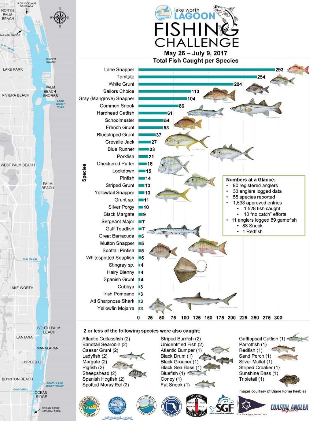
4 2017 LWL Fishing Challenge
5 Lake Worth Lagoon Initiative Habitat Working Group ERM Habitat Projects April 5, 2018


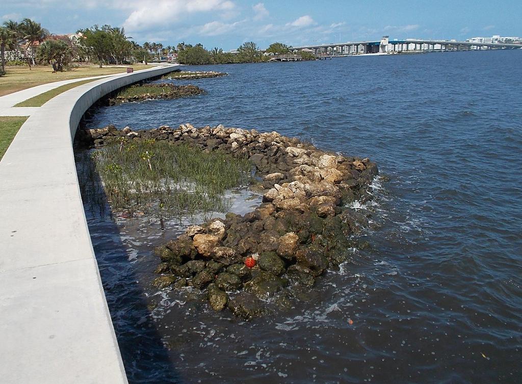
6 Bryant Park Living Shoreline Project Before

7 Volunteers planted Spartina alterniflora and Red Mangroves in the living shoreline planters at Bryant Park

8 Volunteers in Action Local volunteers maintain living shorelines along Lake Worth Golf Course

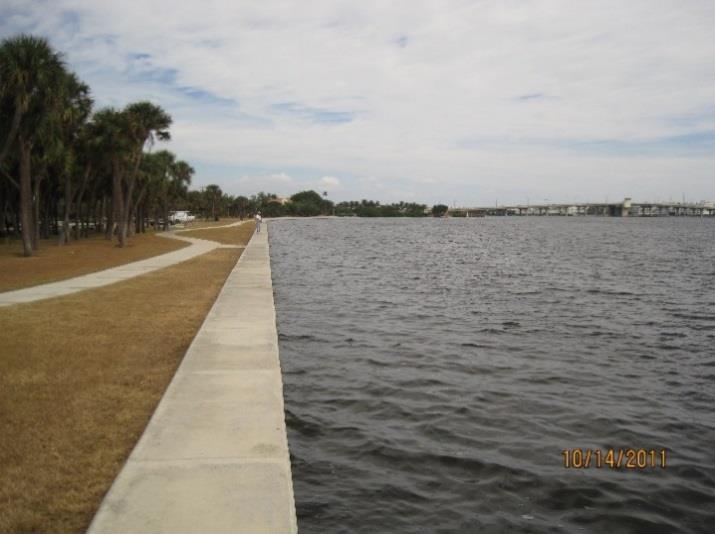
9 Current site conditions


10 Lyman Kayak Park Proposed installation of two mangrove planters 154 linear feet of rip rap 1,244 square feet of planting area

11 Coyote sighting in the Lake Worth Lagoon!


12 Southern Blvd. Bridge Reef Site is ~2 ac. Material from the bridge will be available for placement in June. West Palm Beach Fishing Club was in support of additional LWL artificial reefs.
13 Tarpon Cove Chain of intertidal islands ½ mile in length 250 Capping muck sediments to create 46 acres of habitat ~440 Offshore / ~250 from ICW Kayak Blueway Trail ~400,000 cy of material ~16,000 tons of rock 35 acres sav 2.7 acres intertidal 2.1 acres reef / breakwater

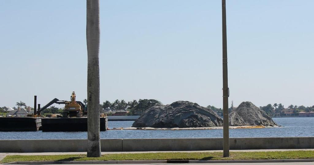
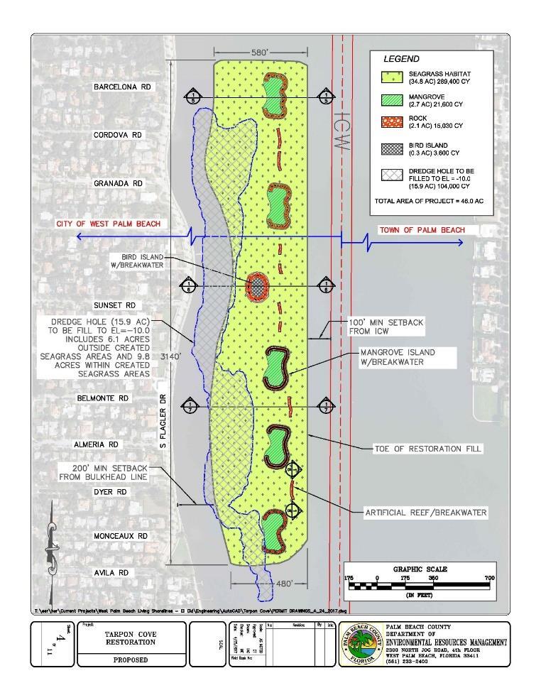
14 Tarpon Cove

15 Enhancements to Bryant Park Snook Islands II Bird Nesting Berm With Shell Layer Grassy Flats Bird Nesting Berm With Shell Layer
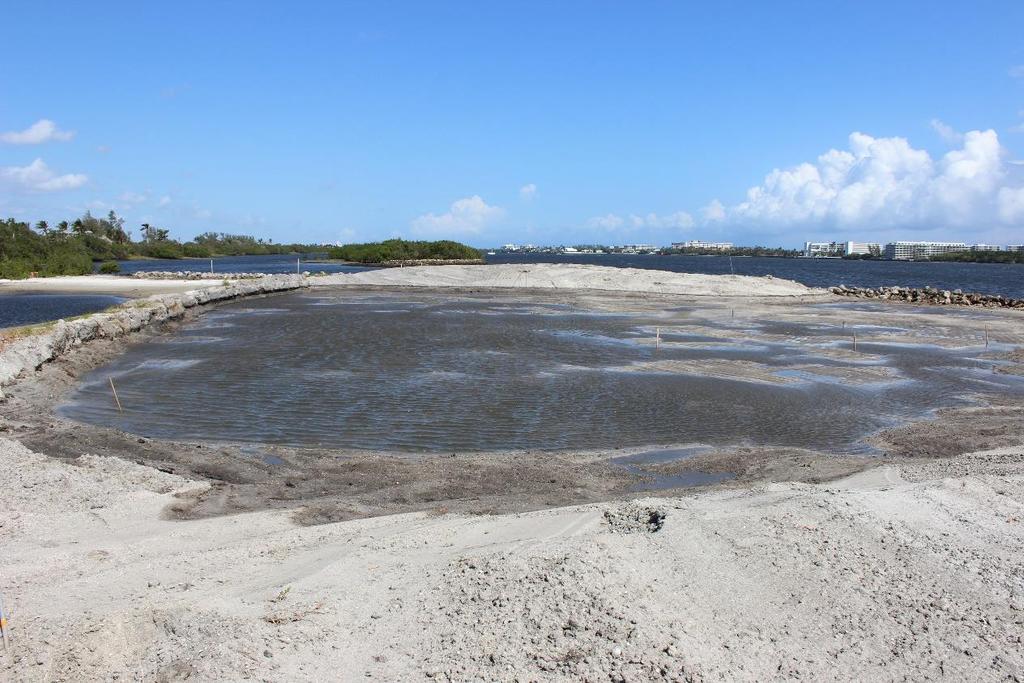
16 Enhancement to Snook Islands
17 Enhancement to Grassy Flats


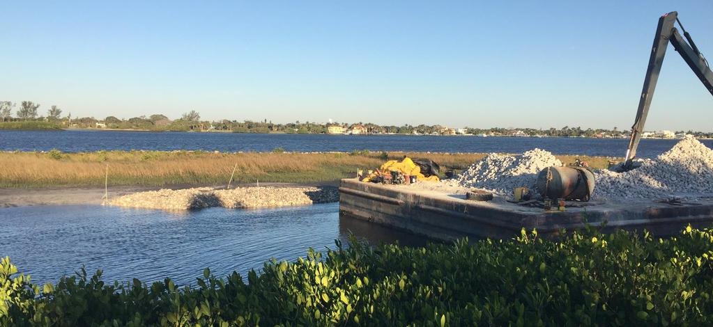
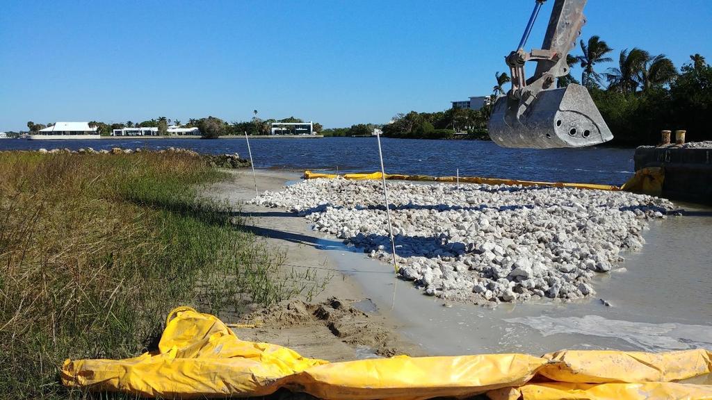
18 Enhancements to Bird Islands Snook Islands II Bird Nesting Berm With Shell Layer Grassy Flats Bird Nesting Berm With Shell Layer 57 Stone along the shoreline at Bryant
")


19 Enhancements to Bird Islands at Snook, Bryant Park, & Grassy Flats 1) Island/bird nesting area enhancements 98% complete. 2) AMOY s nesting at Bryant, Snook II, and Grassy Flats. 3) No LETE sighted yet. Bryant Park Nest Snook II Nest
 planters.")


20 Monceaux Park A series of three (3) planters. Construction of limestone planters to create 0.2 acres of intertidal habitat. Installation of limestone riprap to provide oyster habitat and wave attenuation.
 planters and two (2)")


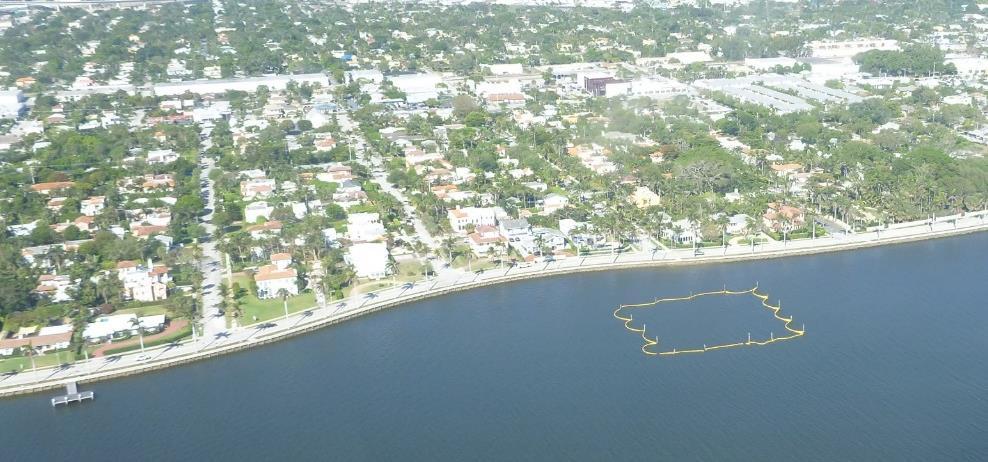
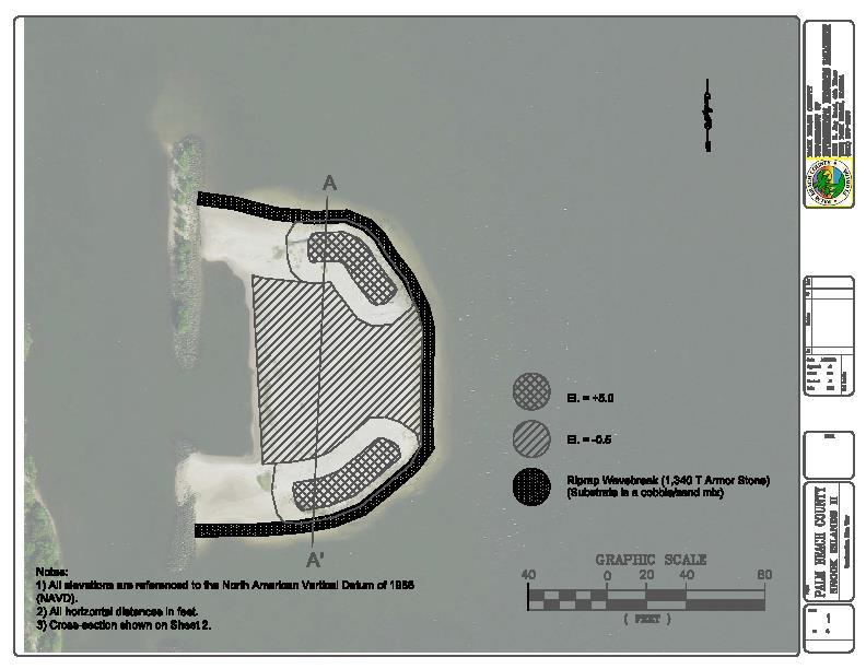
21 Providencia Park A series of three (3) planters and two (2) islands. ~60,000 cy of sand Capping muck sediments to create 6 acres of habitat. ~350 Offshore / ~200 from ICW Kayak Blueway Trail

 Questions, call 561-233-2400 or email")
22 Lake Worth Lagoon Legislative Funding Request Application Period Task Start Date End Date May 11, 2018 August 3, 2018 Last day to submit a project application August 3, 2018 Selection Committee Meeting Applicant Presentations and Ranking August 16, 2018 LWLI Steering Committee Meeting Announce project ranking September 21, Legislative Session Opens March 2019 May 2019 Funding becomes available pending agreement with FDEP July 1, 2019 At FDEP s discretion (typically months) Questions, call or ERM-LWLI@pbcgov.org


23 2018 LagoonFest Save the Date! Saturday November 3, 2018
24 Lake Worth Lagoon Initiative Public Outreach Working Group Meeting April 10, to 11:30 At UF/IFAS Palm Beach County Extension Office at the beautiful Mounts Botanical Gardens campus (531 N Military Trail, West Palm Beach, FL 33415). PRESENTATION: Laurie Albrecht Reducing pollution runoff to the LWL. Prevention techniques using Florida friendly plants
 Boynton Inlet Contributing Area Watershed Planning Update Kurtis Gregg (ERT, Inc.")
25 Lake Worth Lagoon Initiative Water Resources Working Group Meeting April 13, to 12 WHERE: South Florida Water Management District HQ 3301 Gun Club Road PRESENTATIONS: Sewage Disposal Systems in the Lake Worth Lagoon Watershed Timothy Mayer (Florida Health Palm Beach County) Boynton Inlet Contributing Area Watershed Planning Update Kurtis Gregg (ERT, Inc., in support of NOAA-Fisheries Service) Lake Worth Waterkeeper Reinaldo Diaz (President of Lake Worth Waterkeeper)
Lake Worth Lagoon Initiative Habitat Working Group April 5, :00am 12:00pm
 Lake Worth Lagoon Initiative Habitat Working Group April 5, 2018 10:00am 12:00pm Palm Beach County Environmental Resources Management 2300 North Jog Road 1 st Floor Vista Center 1E-60 West Palm Beach,
Lake Worth Lagoon Initiative Habitat Working Group September 11, :00pm 4:00pm
 Lake Worth Lagoon Initiative Habitat Working Group September 11, 2018 2:00pm 4:00pm Palm Beach County Environmental Resources Management 2300 North Jog Road 1 st Floor Vista Center 1E-60 West Palm Beach,
Palm Beach County. Estuarine Habitat Mapping
 Palm Beach County Estuarine Habitat Mapping Coastal Habitat Integrated Mapping and Monitoring Program (CHIMMP) April 29, 2014 Eric Anderson, Environmental Analyst Palm Beach County Department of Environmental
Cat Island Chain Restoration Project Brown County Port & Resource Recovery Department
 Cat Island Chain Restoration Project Brown County Port & Resource Recovery Department February 2, 2015 Fox River and Lower Green Bay Cat Island Chain - 1938 Cat Island Brown County Aerial Photography,
Tampa Bay: Planning for large(r)- scale oyster monitoring
- scale oyster monitoring") Tampa Bay: Planning for large(r)- scale oyster monitoring Gary Raulerson, Ecologist Tampa Bay Estuary Program May 23, 2018 OIMMP Workshop GTM Research Reserve Ponte Vedra Beach, FL Photo Credit: C. McIvor,
Tampa Bay: Planning for large(r)- scale oyster monitoring Gary Raulerson, Ecologist Tampa Bay Estuary Program May 23, 2018 OIMMP Workshop GTM Research Reserve Ponte Vedra Beach, FL Photo Credit: C. McIvor,
Coastal Wildlife Conservation Initiative
 Coastal Wildlife Conservation Initiative What is the Coastal Wildlife Conservation Initiative? A partnership strategy to address coastal issues that impact wildlife and their habitats USFWS CWCI Vision
9:40-10:00: Summary of route surveys conducted by FSA in 2014 in Volusia County
 Volusia Shorebird Partnership Pre-Season Meeting Minutes Monday March 16, 2015, 9:30-12:00 p.m. Beach Safety Headquarters, 3 rd floor conference room 515 S. Atlantic Ave. Daytona Beach, FL Meeting Agenda
Flagler Park Living Shoreline Monitoring Vincent Encomio, Pam Hopkins, Katie Tiling, Josh Mills 9/23/2016
 FLORIDA OCEANOGRAPHIC SOCIETY Flagler Park Living Shoreline Monitoring 2015-2016 Vincent Encomio, Pam Hopkins, Katie Tiling, Josh Mills 9/23/2016 Flagler Living Shoreline Monitoring Summary Constructed
Ray Allen Executive Director (361)
") Ray Allen Executive Director (361)885-6204 rallen@cbbep.org www.cbbep.org CBBEP History 1987 U.S. Congress established the National Estuary Program (NEP) to promote longterm planning and management of
Ray Allen Executive Director (361)885-6204 rallen@cbbep.org www.cbbep.org CBBEP History 1987 U.S. Congress established the National Estuary Program (NEP) to promote longterm planning and management of
Welcome to: Mangroves A to Z. Special thanks:
 Welcome to: Mangroves A to Z Special thanks: Our Presenters: Wayne Blythe, SFWMD Heather Carman, SFWMD Richard Cervi, Cervi Associates Katy Collins, FDEP Kate Davis, Davis Environmental Solutions Brandon
Geographic Response Plan Map: SC-56. Map Continued on SC-50 XXX. Fripps Inlet. Raptor Nesting Area. Recreational Fishing. Sea Turtles.
 32 22'30"N Map Continued on SC-55 80 30'0"W X ull et SC56-01 Story/Harbor River Junction Story River!h!S(!d Old House Creek 1050 [ 400 1000 SC56-03 Old House Creek «Geographic Response Plan Map: SC-56
State of New Jersey Chris Christie, Governor. Dept. of Environmental Protection Bob Martin, Commissioner
 Cape May Beach 2016/2017 Renourishment Cape May Inlet to Lower Township & Lower Cape May Meadows Cape May Point Cape May County, New Jersey New Jersey Department of Environmental Protection Engineering
Geographic Response Plan Map: SFL-31. Bradley. Map continued Key on: SFL-34. Key. Murray Key XXX SFL Clive Key XXX. SFL31-06 Clive Key
 ! 1550 1450 81 0'0"W # [\ m [] Geographic Response Plan Map: SFL-31 Bradley Map continued on: SFL-34 Jow Kemp Florida Bay 80 52'30"W 25 7'30"N 1550 1350 SFL31-01 Conchie Channel SFL31-02 Oyster Oyster
Oil Spill Funds and the Opportunities they Present for Galveston Bay
 Oil Spill Funds and the Opportunities they Present for Galveston Bay A presentation to Texas Environmental Grantmakers Group By Bob Stokes, President, Galveston Bay Foundation Friday, October 31, 2014
Rookery Island Clean Ups Remove 8,000 Pounds of Trash and Debris by Kathryn Tunnell
 Stay connected with The Edge: News and Updates from the Coastal Bend Bays & Estuaries Program News and Updates from the Coastal Bend Bays & Estuaries Program Visit Our Website Rookery Island Clean Ups
Current Water Quality Conditions and Initial Documentation of Hydrilla (Hydrilla verticillata) in Harveys Lake, Luzerne County, PA
 in Harveys Lake, Luzerne County, PA") Current Water Quality Conditions and Initial Documentation of Hydrilla (Hydrilla verticillata) in Harveys Lake, Luzerne County, PA New York State Federation of Lake Associations 4 th 5 th May 2018 Fred
Current Water Quality Conditions and Initial Documentation of Hydrilla (Hydrilla verticillata) in Harveys Lake, Luzerne County, PA New York State Federation of Lake Associations 4 th 5 th May 2018 Fred
Santa Clara Valley Habitat Plan
 Santa Clara Valley Habitat Plan Joint Governing & Implementation Board Meeting Burrowing Owl Survey Summary and Fee Map January 15, 2015 29 1 Agenda Brief Overview of the Key Aspects of the Burrowing Owl
1. Qualitative Assessment... II-101
 Table of Contents I. Introduction... I-1 A. Session Law 2009-479 / House Bill 709... I-2 B. Public Consultation... I-3 C. Selection of Study Sites... I-5 D. Limitations of Study... I-8 II. Physical Assessment...
Site Description: Gull Rock is located approximately 0.4 miles offshore and about six miles north of Yaquina Head in Lincoln County, Oregon.
 Devil s Punchbowl intertidal area Gull Rock (offshore) 12. Gull Rock Site Description: Gull Rock is located approximately 0.4 miles offshore and about six miles north of Yaquina Head in Lincoln County,
John s Island Lake Worth Lagoon Standards (NGSSS) Nancy Kinard K-12 STEM Manager Tom Salinsky K-5 Science Program Planner
 Nancy Kinard K-12 STEM Manager Tom Salinsky K-5 Science Program Planner") WWW.LWLI.ORG John s Island Dear Teachers, The Department of Secondary Education is pleased to make Lake Worth Lagoon Discover a Local Treasure available to all 5th and 8th grade students in the School
WWW.LWLI.ORG John s Island Dear Teachers, The Department of Secondary Education is pleased to make Lake Worth Lagoon Discover a Local Treasure available to all 5th and 8th grade students in the School
Geographic Response Plan Map: EFL-56. Map Continued on Page: GA-37. George Crady Fishing Pier State Park. Amelia Island State Park
 30 37'30"N 81 30'0"W Big Piney Island Nassau River - St. Johns River Marshes k Aquatic Preserve!d!] Crane Island AB A1A ") 108! Geographic Response Plan Map: EFL-56 AB 200 Map Continued on Page: GA-37
Dredging, Beach Nourishment and. Bird Conservation Workshop Atlantic Coast Region
 Dredging, Beach Nourishment and US Army Corps Bird Conservation Workshop Atlantic Coast Region Beach Nourishment and Bird Habitat Restoration in Southern New Jersey Shore Protection and Ecosystem Restoration
Backcountry Management. Anne Morkill Wildlife Refuge Manager U.S. Fish & Wildlife Service
 Backcountry Management Anne Morkill Wildlife Refuge Manager U.S. Fish & Wildlife Service Florida Keys National Marine Sanctuary Advisory Council Duck Key, FL February 21, 2012 Overview of National Wildlife
Marine Corps Support Facility-Blount Island: Integrated Natural Resources Program Successes. E2S2 Conference May 12, 2011
 Marine Corps Support Facility-Blount Island: Integrated Natural Resources Program Successes E2S2 Conference May 12, 2011 Shari Kennedy, MCSF-BI Robert Price, CH2M HILL Location Mission The mission of Marine
The Long Point Causeway: a history and future for reptiles. Scott Gillingwater
 The Long Point Causeway: a history and future for reptiles Scott Gillingwater Environmental Effects Long Point World Biosphere Reserve UNESCO designated the Long Point World Biosphere Reserve in April
TWIN ISLES COUNTRY CLUB AUDUBON COOPERATIVE SANCTUARY PROGRAM
 TWIN ISLES COUNTRY CLUB AUDUBON COOPERATIVE SANCTUARY PROGRAM What is the Audubon Cooperative Sanctuary Program? The Audubon Cooperative Sanctuary Program helps golf courses to enhance wildlife habitats
Gulf of Mexico. Lido Key, Sarasota County Florida Hurricane and Storm Damage Reduction Project Aerial Map. Notes: Legend: #0 FDEP Monuments R-35 R-34
 466500 1086000 467000 1085500 R-35 1085000 467500 1084500 BENJAMIN FRANKLIN DR T-36 1084000 R-34 North Lido Public Beach G:\Enterprise\Sarasota\150252_Lido_Key_Storm_Damage_Reduction_Project_Permitting\MXD\Lido_Key_Aerial_a.mxd
Nature-Based Tourism in Coastal Alabama
 Nature-Based Tourism in Coastal Alabama Chandra Wright Nature Tourism Specialist What Do We Have Besides Beautiful Beaches? Alabama s Natural Treasures Ranks 5 th in the United States in number of species
Northeast Florida Coastal Wetland Restoration Program A Partnership Based Regional Approach for Estuary Habitat Restoration
 Northeast Florida Coastal Wetland Restoration Program A Partnership Based Regional Approach for Estuary Habitat Restoration Paul Haydt Restore America s Estuaries November 15, 2010 St Johns River Water
VERONA WALK COMMUNITY DEVELOPMENT DISTRICT COLLIER COUNTY REGULAR BOARD MEETING FEBRUARY 18, :00 A.M.
 VERONA WALK COMMUNITY DEVELOPMENT DISTRICT COLLIER COUNTY FEBRUARY 18, 2016 10:00 A.M. Special District Services, Inc. The Oaks Center 2501A Burns Road Palm Beach Gardens, FL 33410 www.veronawalkcdd.org
Environmental Protection
 Myakka Wild and Scenic River Program 2017 Annual Report 1 A. Permitting & Regulatory issues 1. Construction continues at the bridge replacement at C.R. 780. MRP030314 was issued to Sarasota County on March
The Laughing Gull. President s Message. Inside This Issue OCTOBER 2018 VOLUME 44, ISSUE 1. By Eva Ries
 OCTOBER 2018 VOLUME 44, ISSUE 1 The Laughing Gull President s Message By Eva Ries Welcome back! Our first chapter meeting for the season is Thursday, October 4 th, and our speaker will be Conservation
FWC Proposed CWA s in Southwest Florida Could Impact Boa;ng
 FWC Proposed CWA s in Southwest Florida Could Impact Boa;ng CWAs (Cri)cal Wildlife Area s) are established by FWC to protect important concentra)ons of wildlife and manage human ac)vi)es to minimize and
Canal Current. Environmental News. Native Plant profile
 Canal Current A wave of information for Cape Coral s Canalwatch volunteers Newsletter: 1 st Quarter 2011 Environmental News The BP Oil Spill, 1 year Later The one year anniversary of the BP Deep Water
DREDGED MATERIAL SETTLEMENT FROM MARSH CREATION PROJECTS CONDUCTED IN COASTAL LOUISIANA
 DREDGED MATERIAL SETTLEMENT FROM MARSH CREATION PROJECTS CONDUCTED IN COASTAL LOUISIANA Thomas McGinnis CPRA Operations Division Lafayette Regional Office National Conference on Ecosystem Restoration August
APPENDIX M BIRD NESTING DATA ( )
") APPENDIX M BIRD NESTING DATA (1984-2011) Final Environmental Impact Statement Village of Bald Head Island Shoreline Protection Project Brunswick County, North Carolina Date Species Number of Birds Number
APPENDIX M BIRD NESTING DATA (1984-2011) Final Environmental Impact Statement Village of Bald Head Island Shoreline Protection Project Brunswick County, North Carolina Date Species Number of Birds Number
Shorebird Roost Rehabilitation at Stockton Sandspit. Project Report 2016
 Shorebird Roost Rehabilitation at Stockton Sandspit Introduction Project Report 2016 Stockton Sandspit is a small but vital component of the Hunter Wetlands National Park and is regarded as one of the
Stay Out Zones and Boom Priorities for Shorebirds in Franklin County
 Stay Out Zones and Boom Priorities for Shorebirds in Franklin County C All the Coastal Beaches that are Publically Owned (State and Federal) have use by nesting birds. These areas are posted. BMPs for
Matagorda Bay Nature Park
 Matagorda Bay Nature Park N a t u r a l S c i e n c e E d u c a t i o n P r o g r a m s This is such a wonderful facility and the location lends itself to teaching about the coastal environment. This is
Lisa B. Beever Greater Everglades Ecosystem Restoration Conference July 15, 2010
 Lisa B. Beever Greater Everglades Ecosystem Restoration Conference July 15, 2010 Climate Ready Estuaries Partnership with 15 NEPs and EPA Barnegat Bay NEP www.epa.gov/cre Comprehensive Conservation and
Detailed Lighthouse Reef Adventure Itinerary 'Classic Lighthouse Reef 8 Night Adventure'
 [1] Share: var switchto5x = true;stlight.options({"publisher":"dr-61cbf29c-70b8-a347-48ed-c13d26df1b16"}); Detailed Itinerary 'Classic Lighthouse Reef 8 Night Adventure' Beyond the Barrier Reef, past Turneffe
Project Title: Lewis Woodpecker Nesting Box FWCP: COL-F17-W Prepared for: Fish and Wildlife Compensation Program. Prepared by: Richard Hoar
 Project Title: Lewis Woodpecker Nesting Box FWCP: COL-F17-W-1219 Prepared for: Fish and Wildlife Compensation Program Prepared by: Richard Hoar Prepared with financial support of the Fish and Wildlife
CORE *REQUIRED OF ALL COMMUNITIES* CIIY TOWN COUNIY YES YES YES YES YES
 CORE *REQUIRED OF ALL COMMUNITIES* ACTIVIIY COUNIY CIIY SEMI 1. Host a Community Wildlife Project Meeting 2. Add at least 4 books or videos dealing with wildlife or wildlife conservation to a school or
Ramsar Convention. LI To know and understand the purpose of the Ramsar Convention
 Ramsar Convention LI To know and understand the purpose of the Ramsar Convention Warm Up Change the following statements so they are appropriate for a report: 1 2 3 4 5 We conducted a beach survey last
2017 Annual Volunteer Report
 2017 Annual Volunteer Report Volunteer Statistics Summary 23,164 DNR 280,419 Hours Donated 135 FTE s (Full Time Equivalents based on a 40-hour work week or 2,080 hours/year.) Volunteer hours are equivalent
Erie County Van Trip. Pipe Creek Wildlife Area
 Erie County Van Trip ***See red markings on maps indicating the best birding options at each location. Please note that you are not limited to these areas, they are just the areas we feel will be most
A Photography Road Trip to Central Florida
 A Photography Road Trip to Central Florida Digital Photography Club of Annapolis 03/14/2011 Lauren (Laurie) Brice 1 2 Agenda Planning your trip While you are there When you return 3 Introduction Why Central
Coastal Virginia Offshore Wind partnership with Orsted. February 2018 Update
 Coastal Virginia Offshore Wind partnership with Orsted February 2018 Update 1 Coastal Virginia Offshore Wind Project: Lease Update Research and Commercial Lease Areas Phase 1 CVOW Lease Area (2,135 acres)
Regional Overview of Current Terrapin Collaboration
 Regional Overview of Current Terrapin Collaboration TOM MOHRMAN The Nature Conservancy in Mississippi Gulf Coast Regional Co-Chair, Diamondback Terrapin Working Group Photo credits: (top) Daniel & Robbie
Hawaii, Big Island Waterfalls, Volcanoes & Stars with Explorer of Light, Jennifer Wu September 20-23, 2014
 Hawaii, Big Island Waterfalls, Volcanoes & Stars with Explorer of Light, Jennifer Wu September 20-23, 2014 Tentative Schedule Sunrise 6:09 am and Sunset 6:18 pm Day 0 - September 19 8:00-9:30 pm Registration,
[ Gull/Tern Nesting Area
 33 30'0"N 79 15'0"W Geographic Response Plan Map: SC-10 Georgetown County Chapel Creek Tho roughfar e C reek Holly Hill 550 200 SC10-04 (tidal flats) 79 7'30"W Br ook g Sandhole Creek Oaks Island 33 30'0"N
2/26/ % located in Collier, Lee, Monroe, Dade Ten Thousand Islands region Tampa Bay & Indian River Lagoon Largest mangrove forest in USA
 Mangroves Florida: 190,000 hectares of mangrove 90% located in Collier, Lee, Monroe, Dade Ten Thousand Islands region Tampa Bay & Indian River Lagoon Largest mangrove forest in USA Mangroves: tropical
National Fish and Wildlife Foundation Executive Summary for the American Oystercatcher Business Plan
 National Fish and Wildlife Foundation Executive Summary for the American Oystercatcher Business Plan October 26, 2008 AMOY Exec Sum Plan.indd 1 8/11/09 5:24:00 PM Colorado Native Fishes Upper Green River
Update on American Oystercatcher Reseach and Conservation in New Jersey
 Update on American Oystercatcher Reseach and Conservation in New Jersey - 2007 Todd Pover, New Jersey Division of Fish and Wildlife - Endangered and Nongame Species Program Tom Virzi, PhD Candidate Department
Wendy Webber Regional Director Northeast Regional Office U.S. Fish and Wildlife Service 300 Westgate Center Drive Hadley, MA
 Robert P. LaBelle, Federal Co-lead April 13, 2017 Mid-Atlantic Regional Planning Body BOEM 45600 Woodland Road, Mailstop: VAM-BOEM DIR Sterling, VA 20166 Betsy Nicholson, NE RPB Federal Co-lead NOAA National
RESTORE ACT Direct Component. Multiyear Implementation Plan Narrative. Plaquemines Parish
 Direct Component Multiyear Implementation Plan Narrative Plaquemines Parish Date: February 24 th, 2015 Eligible Applicant: Point of Contact Name: Point of Contact Title: Plaquemines Parish, Louisiana Amos
2016 Florida 4-H Marine & Aquatic Photography Contest
 2016 Florida 4-H Marine & Aquatic Photography Contest Rules and Guidelines About the Contest The Marine/Aquatic Photography contest provides 4-H youth with opportunities to practice and be recognized for
Conserving the mangrove forests.
 Conserving the mangrove forests. The mangrove forests of Pretty Pool Creek and Four Mile Creek not only lend a unique beauty to the area, they also serve an important role in the environment s ecosystem.
Golf Course Water and Energy Conservation
 Golf Course Water and Energy Conservation The Landings Club Skidaway Island, GA Chris Steigelman The Landings Club on Skidaway Island Director of Golf Course Maintenance 912-695-7243 ChrisS@Landingsclub.com
A Rising Tide: Conserving Shorebirds and Shorebird Habitat within the Columbia River Estuary
 A Rising Tide: Conserving Shorebirds and Shorebird Habitat within the Columbia River Estuary By Vanessa Loverti USFWS Migratory Birds and Habitat Programs, Portland, Oregon May 28, 2014 Outline of Talk
Carl Alderson, NOAA Restoration Center
 `` U.S. Department of Commerce National Oceanic and Atmospheric Administration National Marine Fisheries Office of Habitat Conservation Restoration Center Analysis and Assessment of Thirty Years of Wetland
BIRD READING ASSIGNMENT
 Ocean Connectors BIRD READING ASSIGNMENT To do before the field trip, in class or at home 1. Students will read Wetland Neighbors. The reading is available on the next page and online at http://oceanconnectors.org/resources.
Kishwaukee Audubon Society
 Inventory of the Kishwaukee Audubon Society DeKalb, Illinois Records In the Regional History Center RC 107 1 INTRODUCTION Linda K. Southern, President, donated the Kishwaukee Audubon Society Records to
Cleveland Lakefront Nature Preserve: A Unique Urban Wildlife Haven on Lake Erie
 CLEVELAND-CUYAHOGA COUNTY PORT AUTHORITY Cleveland Lakefront Nature Preserve: A Unique Urban Wildlife Haven on Lake Erie 2012 AAPA Environmental Awards Competition May 2012 Contact Brian Lynch Vice President,
Minnesota Department of Natural Resources
 Minnesota Department of Natural Resources Fisheries Management DRAFT VERSION - PRELIMINARY DATA (AS OF /2/21) Lake Name: String Survey Type: Standard Survey DOW Number: 17-24- Survey ID Date: /8/21 Lake
Division: Habitat and Species Conservation Authors: Claire Sunquist Blunden and Brad Gruver
 Division: Habitat and Species Conservation Authors: Claire Sunquist Blunden and Brad Gruver Report date: December 13, 2018 All photos by FWC unless otherwise acknowledged Presenting 6 new guidelines 1
Paluma Environmental Education Centre
 Paluma Environmental Education Centre Science (Biology) Field Workbook for Picnic Bay Year 4 Unit 2 Mapping the life cycle and survival of the Bush stone-curlew My Name: My Class: My working group: My
JOB ANNOUNCEMENT. Eastern Oregon Field Coordinator
 JOB ANNOUNCEMENT Job Title: Department: Reports to: Classification: Pay rate: Location: Eastern Oregon Field Coordinator Conservation Department Director of Conservation Non-exempt, Full-time $23/hour
Beaver Island Archipelago: Invasive Species Control Final Report Submitted by:
 Beaver Island Archipelago: Invasive Species Control Final Report Submitted by: 4371 N Long Lake Rd Traverse City, MI 49684 wildlife@wildlifewetlands.com (231) 943-0762 Project Plan and Schedule 2014 Treatment
In this issue. Events & reminders. Events & reminders. 2. FSA news FSD updates.. 7. Ebb tidings... 9
 APRIL 2014 1 In this issue Events & reminders. 2 FSA news... 3 Highlights from the 2014 Winter Shorebird Survey Expanded shorebird monitoring in the panhandle FSD updates.. 7 2014 Breeding Season begins!
4-H Conservation Guidelines
 4-H Conservation Guidelines The following are guidelines for providing learning experiences in the conservation project area. THE GUIDELINES FOR ALL MEMBERS Understand what Natural Resources are; how to
CBOCS 5 th Anniversary Annual Meeting WELCOME PLEASE SIGN INTRODUCTIONS
 CBOCS 5 th Anniversary Annual Meeting WELCOME PLEASE SIGN INTRODUCTIONS CBOCS Missions PRIMARY Host Oyster Spat on Shell for 1 year PARALLEL Educate youth Monitor water quality Outreach to community Enhance
WATER BIRDS OF PALM BEACH COUNTY
 WATER BIRDS OF PALM BEACH COUNTY Presented by : The Audubon Society of the Everglades www.auduboneverglades.org Text and Photographs by Larry Hess Types of Water Birds Seen in Palm Beach County Ducks and
Spring-Summer Issue 66. The Great Egg Harbor Watershed Association s website has a new look. Check us out.
 Spring-Summer 2015 www.gehwa.org Issue 66 The Great Egg Harbor Watershed Association s website has a new look. Check us out. National Park Foundation 2014 Impact Grant In 2014 the National Park Foundation,
CHOCTAWHATCHEE AUDUBON SOCIETY P. O. Box 1044, Niceville, Florida ChoctawhatcheeAudubon.org
 CHOCTAWHATCHEE AUDUBON SOCIETY P. O. Box 1044, Niceville, Florida 32588 ChoctawhatcheeAudubon.org Hi fellow Audubon members, wildlife photographers, nature lovers, and friends, September 1, 2016 Veterans
New Jersey Dept. of Environmental Protection Shore Protection Program
 New Jersey Dept. of Environmental Protection Benjamin Keiser, Manager 1510 Hooper Avenue, Suite 140 Toms River, New Jersey 08753 1-732-255-0767 New Jersey s State of New Jersey Chris Christie, Governor
Expansion Work Has Begun The perimeter dike for Cell 7 is now visible
 Summer/Fall 2017 In This Issue Poplar Island Expansion Wetland Cell 5AB Development Wildlife Update Birding tours on Poplar Island Expansion Work Has Begun The perimeter dike for Cell 7 is now visible
Geographic Response Plan Map: SFL-41
 ! 400!!!! iscayne Bay Aquatic reserve ey X 25 22'30"N Map continued on: SFL-42 k Barnes Sound SFL42-01 FKNMS SFL-42 u Florida Keys ational Marine Sanctuary 25 15'0"N 80 22'30"W Environmentally Sensitive
Geographic Response Plan Map: SC-50. Map Continued on SC-42. St Helena Sound. SC50-04 Ashepoo River. Combahee. Bank
 Back -05 e Morgan Village Creek # 32 30'0"N Beaufort County Coosaw R Creeks Map Continued on SC-49 750 900 SC42-03 ICWW - 80 30'0"W Coosaw River iver 1050 1050 Coosaw River Morgan Back Creeks Village Creek
Corps Dredge Plan 2016 Emily Hughes Env Resources, USACE BUILDING STRONG
 Corps Dredge Plan 2016 Emily Hughes Env Resources, USACE Goodbye Jeff Richter!! Navigation/Operations USACE Goal/Mission: To maintain safe Navigation in Federal Channels using methods that are most (1)
Minnesota Department of Natural Resources
 Minnesota Department of Natural Resources Fisheries Management VERSION - PRELIMINARY DATA (AS OF //4) Lake Name: Ocheda Survey Type: Winter Kill Assessment DOW Number: -4- Survey ID Date: //4 Lake Identification
Collaboration and Planning to Implement the South San Diego Bay Restoration and Enhancement Project
 Collaboration and Planning to Implement the South San Diego Bay Restoration and Enhancement Project Carolyn Lieberman Coastal Program Coordinator for Southern California U.S. Fish and Wildlife Service
ENDANGERED PLOVERS SINGING PRAISE FOR NEW NATURE TRUST LANDS
 ENDANGERED PLOVERS SINGING PRAISE FOR NEW NATURE TRUST LANDS NEWS RELEASE Embargoed until August 6 th at 10:30 am. Baccaro, N.S. (August 6) The Nova Scotia Nature Trust made yet another exciting leap forward
AERIAL SURVEY OF BIRDS AT MONO LAKE ON AUGUST 24, 1973
 AERIAL SURVEY OF BIRDS AT MONO LAKE ON AUGUST 24, 1973 by Ronald M. Jurek Special Wildlife Investigations Wildlife Management Branch California Department of Fish and Game September 1973 Jurek, R.M. 1973.
Geographic Response Plan Map: SC-42
 w Bowles SC41-07 New Chehaw 750! 80 30'0"W BASIN NERR 32 37'30"N Map Contined on SC-41 32 30'0"N Beafort Conty Coosaw R Ashepoo 80 30'0"W iver Legend Beet Coosaw [!d Crooked SC42-03 ICWW - Coosaw 650 Rock
Rigs to Reefs? Options for Platform Decommissioning 2010 CONFERENCE. July 23, 2010 from 8:30 AM to 3:30 PM The Waterfront Hilton, Huntington Beach CA
 Rigs to Reefs? Options for Platform Decommissioning 2010 CONFERENCE July 23, 2010 from 8:30 AM to 3:30 PM The Waterfront Hilton, Huntington Beach CA Program Guide PRESENTED BY: Orange County Coastkeeper,
Wetland Restoration at Blackwater NWR. Dixie Birch November 2, 2006
 Wetland Restoration at Blackwater NWR Dixie Birch November 2, 2006 Goal: Restore 20,000 acres In Dorchester County including 11,000 at Blackwater Strategic Partnerships Remaining marsh shown in red Blackwater
National Audubon Society. Coastal Bird Conservation Program
 National Audubon Society Coastal Bird Conservation Program Coastal Bird Conservation Program This presentation contains original photos and data. For any use of this information, data, maps, or photographs
March 2016 Tiny Trekkers Oliver s Tree from 10:00-11:00 a.m. Saturday, March 5. Florida s Sandhill Cranes from 2:00-3:00 p.m. Saturday March 5.
 March 2016 Tiny Trekkers Oliver s Tree from 10:00-11:00 a.m. Saturday, March 5. Follow along as we read a book about a sweet-faced rabbit, a little owl and other animals as they play hide-and-seek. This
Texas Artificial Reef Program 2015 Year in Review. Texas Parks and Wildlife Department Artificial Reef Program J. Dale Shively 15 March 2016
 Texas Artificial Reef Program 2015 Year in Review Texas Parks and Wildlife Department Artificial Reef Program J. Dale Shively 15 March 2016 Texas Artificial Reef Program by the Numbers Over 4,800 Acres
Marion Audubon Society The Scrub Jay November 2018
 Marion Audubon Society The Scrub Jay November 2018 Photos by Holly Yocum November Issue: The Scrub Jay by Marty Schwartz, Editor The Scrub Jay will be published monthly including upcoming events, news
1: Season Summaries 2018 Season Summary 1:45 FSD Custom Search Function Tutorial FSD Custom Search Tutorial 1:55 MBTA updates
 St. Johns and Flagler Shorebird Partnership 2018 Post-season Meeting Notes Thursday, October 11 th, 1PM 4PM St. Augustine Alligator Farm Conference Room, St. Augustine 1:00 Videos and Introductions In
FOR SALE. Wyatt Ranch Ranch, County Road 59, Chapman Ranch, TX
 Wyatt Ranch Ranch, County Road 59, Chapman Ranch, TX Size: Approximately 237.69 acres Price: $2,330,000 (Price/acre: $9,800) Legal Description: LAURELS FARM TRACTS Comments: This site was originally part
Aythya nyroca Eastern Europe/E Mediterranean & Sahelian Africa
 Period 2008-2012 European Environment Agency European Topic Centre on Biological Diversity Aythya nyroca Eastern Europe/E Mediterranean & Sahelian Africa Annex I International action plan Yes SAP Ferruginous
U.S. Fish and Wildlife Service response to Climate Change. Bob Ford Deputy, SE Science Applications Program U.S. Fish and Wildlife Service
 U.S. Fish and Wildlife Service response to Climate Change Bob Ford Deputy, SE Science Applications Program U.S. Fish and Wildlife Service Sam Hamilton Southeast Regional Director, 1997-2009 U.S. Fish and
Adopted March 18, 2008 (Ordinance 08-19) Amended October 21, 2008
 Amended October 21, 2008") RECREATION, OPEN SPACE & CULTURE ELEMENT of the PINELLAS COUNTY COMPREHENSIVE PLAN Prepared By: The Pinellas County Planning Department as staff to the LOCAL PLANNING AGENCY for THE BOARD OF COUNTY COMMISSIONERS
RECREATION, OPEN SPACE & CULTURE ELEMENT of the PINELLAS COUNTY COMPREHENSIVE PLAN Prepared By: The Pinellas County Planning Department as staff to the LOCAL PLANNING AGENCY for THE BOARD OF COUNTY COMMISSIONERS
presentation to Wenatchee North Rotary Club Susan Reynolds Ballinger, founder of Wenatchee Naturalist & Chelan-Douglas Land Trust Conservation Fellow
 Citizen Science- What it is? How you can get involved? April 26, 2017 presentation to Wenatchee North Rotary Club Susan Reynolds Ballinger, founder of Wenatchee Naturalist & Chelan-Douglas Land Trust Conservation
PUBLIC NOTICE. Permit Application No. SAJ (IP-MJD)
") DEPARTMENT OF THE ARMY JACKSONVILLE DISTRICT CORPS OF ENGINEERS FORT MYERS REGULATORY OFFICE 1520 ROYAL PALM SQUARE BOULEVARD, SUITE 310 FORT MYERS, FLORIDA 33919 Regulatory Division South Permits Branch/West
DEPARTMENT OF THE ARMY JACKSONVILLE DISTRICT CORPS OF ENGINEERS FORT MYERS REGULATORY OFFICE 1520 ROYAL PALM SQUARE BOULEVARD, SUITE 310 FORT MYERS, FLORIDA 33919 Regulatory Division South Permits Branch/West
Conservation Lands Program Update July 2017
 Conservation Lands Program Update July 2017 Beth Powell Conservation Lands Manager Wendy Swindell Conservation Lands Technician IRC Environmental Lands CONSERVATION PROGRAM OVERVIEW In 1990, the County
Taking RSM to the Next Level
 Taking RSM to the Next Level Q AVG Jackie Keiser Chief, Coastal and Navigation USACE Jacksonville District Q AVG RSM & EWN In-Progress Review 21 July 2014 US Army Corps of Engineers BUILDING STRONG RSM: