Geographic Response Plan Map: EFL-56. Map Continued on Page: GA-37. George Crady Fishing Pier State Park. Amelia Island State Park
|
|
|
- Annice Benson
- 5 years ago
- Views:
Transcription
1 30 37'30"N 81 30'0"W Big Piney Island Nassau River - St. Johns River Marshes k Aquatic Preserve!d!] Crane Island AB A1A ") 108! Geographic Response Plan Map: EFL-56 AB 200 Map Continued on Page: GA-37 AB A1A Atlantic Ocean 81 22'30"W 30 37'30"N Duval County a c k I s XX H a m l a d n L mpkin l Creek E d w a r d s F l a t s!d Nassau County [j Map Continued on Page: EFL-57 m o c k Pumpkin Hill Creek 30 30'0"N Back River n Ecological & ric Preserve 81 30'0"W EFL Back River Amelia Island Area EFL South Amelia River Nassau River B l a c k H a m m o c k I s l a n d [j Timucuan Ecological & Historic Preserve Alligator Creek Environmentally Sensitive Areas Summer Protection Priority XX X A - Protect First B - Protect after A Areas C - Protect after B Areas Response Methods «Skimmer Shallow Water Skimmer!( h # Collection Point General Booming Strategy (Length in Feet) Incident Command Posts!( S!( R!( F E Staging Areas Oil Spill Risk Sites Equipment Storage Locations Tidal Inlet Protection Strategy ! h ( 1400 EFL Gunnison Cut 300 Harrison Cr. South Amelia River EFL Harrison Creek 300 Sawpit Creek Wal ker Cr. 200 [k [x #!d!s( ]^105A A m e l i a I s l a n d EFL Walker Creek 900 EFL Big Talbot Island State Park Bio-Socioeconomic Beach Access [j! Airport [y Aquaculture Aquatic Preserve/State Park [k Black Bear Habitat [z Boat Ramp!d Coast Guard [s [¼ Diving Gull/Tern Nesting Area!!Å Heliport High Recreational Beach [m!] Marina 900! George Crady Fishing Pier State Park m # [k F [«Nassau Sound Amelia Island State Park EFL Nassau Sound [² EFL Bird Island Map Continued on Page: EFL-55 & Little Bird Island Nassau Sound! Manatee Mangroves [v NERR Sea Turtle Nesting Beach µ Aquaculture Leases National Park [j Federal Managed Areas [w k Naval Facility State Managed Areas [«!d( [x [²!!q [r Piping Plover Power Plant Recreational Fishing Right Whale 300 Sea Turtle Nesting Area Water Intake Wildlife Refuge 700 Nassau County Duval County State Waters/County Line USCG Sector Boundary Northeast & Eastern Central Florida Area Committee Fish and Wildlife Research Institute (FWRI-FWC) Miles k Nassau River - St. Johns River Marshes Aquatic Preserve Sector St. Petersburg 81 22'30"W MSU Savannah Sector Jacksonville Sector Jacksonville Sector Miami 30 30'0"N

2 County unty 30 33'45"N 81 30'0"W Geographic Response Plan Map: EFL-56SW Harrison Cr. EFL Harrison Creek! 81 26'15"W 30 33'45"N m o c k Back River EFL South Amelia River Walker Creek A m e l i a I s l a n d EFL Back River Amelia Island Area Nassau River M e s a M a r s h South Amelia River 300 EFL Walker Creek 200 Pumpkin Hill Creek B l a c k H a m m o c k I s l a n d Nassau County Duval County! h ( 1400 EFL Gunnison Cut [k 900 # AB A1A [k Amelia Island State Park m 30 30'0"N [j Timucuan Ecological & Historic Preserve Sawpit Creek George Crady Fishing Pier State Park!d!S( # Big Talbot Island State Park 900 k F [«Nassau Sound EFL Nassau Sound 30 30'0"N & 81 30'0"W Environmentally Sensitive Areas Summer Protection Priority XX X A - Protect First B - Protect after A Areas C - Protect after B Areas Response Methods «Skimmer Shallow Water Skimmer!( h # Collection Point General Booming Strategy (Length in Feet) Incident Command Posts!( S!( R!( F E Staging Areas Oil Spill Risk Sites Equipment Storage Locations Tidal Inlet Protection Strategy Bio-Socioeconomic Beach Access! Airport [y Aquaculture Aquatic Preserve/State Park [k Black Bear Habitat [z Boat Ramp!d Coast Guard [s [¼ Diving Gull/Tern Nesting Area!!Å Heliport High Recreational Beach [m!] Marina! Manatee [v NERR [j [w [«!d( [x [²!!q [r National Park Naval Facility Piping Plover Power Plant Recreational Fishing Right Whale Sea Turtle Nesting Area Water Intake Wildlife Refuge Mangroves Sea Turtle Nesting Beach Aquaculture Leases Federal Managed Areas State Managed Areas State Waters/County Line USCG Sector Boundary Northeast & Eastern Central Florida Area Committee EFL Big Talbot µ Island State Park Fish and Wildlife Research Institute (FWRI-FWC) Miles Sector St. Petersburg 81 26'15"W MSU Savannah Sector Jacksonville Sector Jacksonville Sector Miami N S
3 GRP - Oil Spill Sensitive Site Report for Sector : Jacksonville GRP Map # EFL-56 Name: Site Description: Harrison Creek Protection Priority (Season): Spring: A Summer: A Fall: A Winter: A Small creek (saltwater/saltmarsh) off of South Amelia River, in Amelia Island Site ID: Latitude (DMS): 30 33' " Longitude (DMS): 81 28' 3.320" W County: Nassau Latitude (DD): Longitude (DD): SCAT Division: Nassau County Division 1 ESI Map: EFL-56 ESI Name: Amelia City, Fla. NOAA Chart 11489_2 CHART Name ST SIMONS SOUND TO TOLOMATO RIVER CC-DD USGS Quad: E4 QUAD Name: Amelia City Managed Area (if applicable): General Location: Contacts: Amelia Island, FL GEOSPATIAL INFORMATION CONTACT INFORMATION EFL FL State Watch Office ; NRC ; FL DEP Aquatic Preserves (Manager) ; FWC Non-Game Biologist ; Nassau County EOC (Mgr) NOAA-SSC (USCG District 7) (o) (c) (24hr); DOI Reg Officer or ; DEP-OER Shoreline Type: Salt marsh, sandy beach RESOURCES AT RISK INFORMATION Habitat: Wildlife: Salt marsh, sandy beach Juvenile fish, shellfish, wading birds rookeries, wintering grounds, shrimp, crabs, sea turtles, marine mammals Threaten/Endangered Species: Green, Leatherback, Kemps-Ridley, and Loggerhead Sea Turtles Socio-Economic Resources: Recreational fishing and archaeological sites throughout Staging Area Collection Points: Area Access: Spill Risk: Big Talbot Island State Park North and South sides of A1A Bridge boat Response Resources: RESPONSE CONSIDERATIONS Chemical and #6 Oil barge transport up Nassau River and South Ameilia River PROTECTION STRATEGY INFORMATION Tidal Range (FT): 6 Average Current (KTS): 2 Ease of Protection: Easy Min. Boom Length (FT): 500 Boom Type: Booming Method: Protection/Exclusion Protection Strategy: Deploy 500' of boom across mouth of creek. Report produced by Florida FWC - Fish and Wildlife Research Institue on: Tuesday, July 02, 2013 For additional information, please contact FWC-FWRI Center for Spatial Analysis (727)
4 GRP - Oil Spill Sensitive Site Report for Sector : Jacksonville GRP Map # EFL-56 Name: Site Description: Back River - Amelia Island Area, Florida Protection Priority (Season): Spring: A Summer: A Fall: A Winter: A River Off of Nassau RIver North of Black Hammock Island Site ID: Latitude (DMS): 30 33' 7.548" N Longitude (DMS): 81 29' " County: Duval Latitude (DD): Longitude (DD): SCAT Division: Duval County Division 1 ESI Map: EFL-56 ESI Name: Amelia City, Fla. NOAA Chart 11489_2 CHART Name ST SIMONS SOUND TO TOLOMATO RIVER CC-DD USGS Quad: E4 QUAD Name: Amelia City Managed Area (if applicable): Nassau River - St. Johns River Marshes Aquatic Preserve, Timucuan Ecological and Historic Preserve General Location: Contacts: GEOSPATIAL INFORMATION CONTACT INFORMATION EFL FL State Watch Office ; NRC ; FL DEP Aquatic Preserves (Manager) ; FWC Non-Game Biologist ; NPS Timucuan Ecological and Historic Preserve ; Duval County EOC (Mgr) City of Jax (Envir. and Compliance Dept) ; NOAA-SSC (USCG District 7) (o) (c) (24hr); DOI - Regional Environmental Officer or ; DEP-OER Shoreline Type: Salt marsh RESOURCES AT RISK INFORMATION Habitat: Wildlife: Salt marsh Shellfish harvesting, fish, wading birds rookeries, wintering grounds, crabs, sea turtles, marine mammals Threaten/Endangered Species: Green, Leatherback, Kemps-Ridley, and Loggerhead Sea Turtles Socio-Economic Resources: Recreational fishing Staging Area Collection Points: Area Access: Spill Risk: Big Talbot Island State Park RESPONSE CONSIDERATIONS North and South sides of A1A Bridge, and skimmer at the mouth of Nassau River boat Response Resources: Jacksonville Fire Rescue PROTECTION STRATEGY INFORMATION Tidal Range (FT): 6 Average Current (KTS): 2 Ease of Protection: Medium Min. Boom Length (FT): 1,600 Boom Type: Booming Method: Deflection Protection Strategy: See Nassau Sound TIPS. Deflection boom at fork of Nassau River/South Amelia River to pool product for skimming. Report produced by Florida FWC - Fish and Wildlife Research Institue on: Tuesday, July 02, 2013 For additional information, please contact FWC-FWRI Center for Spatial Analysis (727)
5 GRP - Oil Spill Sensitive Site Report for Sector : Jacksonville GRP Map # EFL-56 Name: Walker Creek Protection Priority (Season): Site Description: Spring: A Summer: A Fall: A Winter: A Small creek (saltwater/saltmarsh) off of South Amelia River, in Amelia Island Site ID: Latitude (DMS): 30 32' " Longitude (DMS): 81 27' " County: Nassau Latitude (DD): Longitude (DD): SCAT Division: Nassau County Division 1 ESI Map: EFL-56 ESI Name: Amelia City, Fla. NOAA Chart 11489_2 CHART Name ST SIMONS SOUND TO TOLOMATO RIVER CC-DD USGS Quad: E4 QUAD Name: Amelia City Managed Area (if applicable): Amelia Island State Recreation Area General Location: Contacts: Amelia Island, FL GEOSPATIAL INFORMATION CONTACT INFORMATION EFL FL State Watch Office ; NRC ; FL DEP Aquatic Preserves (Manager) ; FWC Non-Game Biologist ; Nassau County EOC (Mgr) NOAA-SSC (USCG District 7) (o) (c) (24hr); DOI - Regional Environmental Officer or ; DEP-OER Shoreline Type: Salt marsh, sandy beach RESOURCES AT RISK INFORMATION Habitat: Wildlife: Sandy beach, salt marsh Juvenile fish, shellfish, wading birds rookeries, wintering grounds, shrimp, crabs, sea turtles, marine mammals Threaten/Endangered Species: Green, Leatherback, Kemps-Ridley, and Loggerhead Sea Turtles Socio-Economic Resources: Recreational fishing and archaeological sites throughout Staging Area Collection Points: Area Access: Spill Risk: Big Talbot Island State Park North and South sides of A1A Bridge boat Response Resources: RESPONSE CONSIDERATIONS Chemical and #6 Oil barge transport up Nassau River and South Ameilia River PROTECTION STRATEGY INFORMATION Tidal Range (FT): Average Current (KTS): Ease of Protection: Easy Min. Boom Length (FT): 350 Boom Type: Booming Method: Deflection, Protection/Exclusion Protection Strategy: Deploy 350' of boom across mouth of creek. Report produced by Florida FWC - Fish and Wildlife Research Institue on: Tuesday, July 02, 2013 For additional information, please contact FWC-FWRI Center for Spatial Analysis (727)
6 GRP - Oil Spill Sensitive Site Report for Sector : Jacksonville GRP Map # EFL-56 Name: Site Description: South Amelia River Protection Priority (Season): Spring: A Summer: A Fall: A Winter: A Fork off of Nassau RIver near Amelia Island Site ID: Latitude (DMS): 30 32' 4.844" N Longitude (DMS): 81 27' " County: Nassau Latitude (DD): Longitude (DD): SCAT Division: Nassau County Division 1 ESI Map: EFL-56 ESI Name: Amelia City, Fla. NOAA Chart 11489_2 CHART Name ST SIMONS SOUND TO TOLOMATO RIVER CC-DD USGS Quad: E4 QUAD Name: Amelia City Managed Area (if applicable): Nassau River - St. Johns River Marshes Aquatic Preserve General Location: Contacts: GEOSPATIAL INFORMATION CONTACT INFORMATION EFL FL State Watch Office ; NRC ; FL DEP Aquatic Preserves (Manager) ; FWC Non-Game Biologist ; Nassau County EOC (Mgr) NOAA-SSC (USCG District 7) (o) (c) (24hr); DOI - Regional Environmental Officer or ; DEP-OER Shoreline Type: Salt and brackish water marshes RESOURCES AT RISK INFORMATION Habitat: Wildlife: Salt marsh Juvenile fish, shellfish, wading birds rookeries, wintering grounds, crabs, shrimp, sea turtles, marine mammals Threaten/Endangered Species: Green, Leatherback, Kemps-Ridley, and Loggerhead Sea Turtles Socio-Economic Resources: Archaeological SItes throughout, Barge traffic, and vessel transportation Staging Area Collection Points: Area Access: Spill Risk: Big Talbot Island State Park RESPONSE CONSIDERATIONS North and South sides of A1A Bridge, and skimmer at the mouth of Nassau River boat Response Resources: Chemical and #6 Oil barge transport up Nassau River and South Ameilia River PROTECTION STRATEGY INFORMATION Tidal Range (FT): 6 Average Current (KTS): 3 Ease of Protection: Medium Min. Boom Length (FT): 2,950 Boom Type: Booming Method: Deflection, Protection/Exclusion Protection Strategy: See Nassau Sound TIPS. Deflection boom to pool product for skimming. 250' barrier boom at mouth of creek south of Walker Creek and multiple exclusion booms at creeks mouth leading to Alligator Creek. Report produced by Florida FWC - Fish and Wildlife Research Institue on: Tuesday, July 02, 2013 For additional information, please contact FWC-FWRI Center for Spatial Analysis (727)
7 GRP - Oil Spill Sensitive Site Report for Sector : Jacksonville GRP Map # EFL-56 Name: Site Description: Gunnison Cut Protection Priority (Season): Spring: A Summer: A Fall: A Winter: A Small ICW canal at the near North end of Nassau Sound Site ID: Latitude (DMS): 30 31' " Longitude (DMS): 81 27' " County: Duval Latitude (DD): Longitude (DD): SCAT Division: Duval County Division 1 ESI Map: EFL-56 ESI Name: Amelia City, Fla. NOAA Chart 11489_2 CHART Name ST SIMONS SOUND TO TOLOMATO RIVER CC-DD USGS Quad: E4 QUAD Name: Amelia City General Location: Big Talbot Island State Park GEOSPATIAL INFORMATION EFL Managed Area (if applicable): Nassau River - St. Johns River Marshes Aquatic Preserve, George Crady Bridge Fishing Pier State Park, Timucuan Ecological and Historic Preserve Contacts: CONTACT INFORMATION FL State Watch Office ; NRC ; FL DEP Aquatic Preserves (Manager) ; FWC Non-Game Biologist ; Duval County EOC (Mgr) ; NPS Timucuan Ecological and Historic Preserve City of Jax (Envir. and Compliance Dept) ; NOAA-SSC (USCG District 7) (o) (c) (24hr); DOI - Regional Environmental Officer or ; DEP-OER Shoreline Type: Salt marsh, sandy beach, rip-rap RESOURCES AT RISK INFORMATION Habitat: Wildlife: Salt marsh Juvenile fish, shellfish harvesting, wading birds rookeries, wintering grounds, crabs, sea turtles, marine mammals Threaten/Endangered Species: Green, Leatherback, Kemps-Ridley, and Loggerhead Sea Turtles, Plovers, Least Tern Socio-Economic Resources: Residential area Staging Area Collection Points: Area Access: Spill Risk: Response Resources: Big Talbot Island State Park North and South sides of A1A Bridge boat/vehicle RESPONSE CONSIDERATIONS Chemical and #6 Oil barge transport up Nassau River and South Ameilia River Jacksonville Fire Rescue PROTECTION STRATEGY INFORMATION Tidal Range (FT): 6 Average Current (KTS): 2 Ease of Protection: Medium Min. Boom Length (FT): 2,200 Boom Type: Booming Method: Deflection Protection Strategy: See Nassau Sound TIPS. Deflection boom to guide product to base of A1A Bridge. Place exclusion boom across mouth of cut if necessary. Report produced by Florida FWC - Fish and Wildlife Research Institue on: Tuesday, July 02, 2013 For additional information, please contact FWC-FWRI Center for Spatial Analysis (727)
8 GRP - Oil Spill Sensitive Site Report for Sector : Jacksonville GRP Map # EFL-56 Name: Site Description: Nassau Sound Protection Priority (Season): Spring: A Summer: A Fall: A Winter: A Mouth of the Nassau River (Inlet) Site ID: Latitude (DMS): 30 30' " Longitude (DMS): 81 26' " County: Duval Latitude (DD): Longitude (DD): SCAT Division: Duval County Division 1 ESI Map: EFL-56 ESI Name: Amelia City, Fla. NOAA Chart 11489_2 CHART Name ST SIMONS SOUND TO TOLOMATO RIVER CC-DD USGS Quad: E4 QUAD Name: Amelia City General Location: Big Talbot Island State Park and Amelia Island GEOSPATIAL INFORMATION EFL Managed Area (if applicable): Nassau River - St. Johns River Marshes Aquatic Preserve, Amelia Island State Park, Big Talbot Island State Park, George Crady Bridge Fishing Pier State Park, Timucuan Ecological and Historic Preserve Contacts: CONTACT INFORMATION FL State Watch Office ; NRC ; FL DEP Aquatic Preserves (Mgr) ; City of Jax (Env Dept) ;Duval County EOC (Mgr) ; FWC Non-Game Biologist ; Nassau County EOC (Mgr) Big Talbot Island State Park (Mgr) ; NPS Timucuan Preserve ; DOI - Regional Officer or ; NOAA-SSC (USCG District 7) (o) (c) (24hr); DEP-OER Shoreline Type: Salt marsh, sandy beach RESOURCES AT RISK INFORMATION Habitat: Wildlife: Sandy beach, salt marsh Wading birds, fisheries, shellfish, nesting birds, shorebirds, shrimp, crabs, sea turtles, marine mammals Threaten/Endangered Species: Green, Leatherback, Kemps-Ridley, and Loggerhead Sea Turtles, Plovers, Least Tern Socio-Economic Resources: Fishing and High Recreation Beach Staging Area Collection Points: Area Access: Spill Risk: Response Resources: Big Talbot Island State Park RESPONSE CONSIDERATIONS Mechanical cleanup of beaches/north and South sides of A1A Bridge boat/vehicle Chemical and #6 Oil barge transport up Nassau River Jacksonville Fire Rescue PROTECTION STRATEGY INFORMATION Tidal Range (FT): 6 Average Current (KTS): 3 Ease of Protection: Min. Boom Length (FT): 2,200 Boom Type: Hard Booming Method: Deflection Protection Strategy: See Nassau Sound TIPS. Unable to boom inlet, divert oil to sandy beaches if possible and if shorebirds not nesting especially on Bird Island. 40/60lb anchors should be used to hold booms in place near bridge. Report produced by Florida FWC - Fish and Wildlife Research Institue on: Tuesday, July 02, 2013 For additional information, please contact FWC-FWRI Center for Spatial Analysis (727)
9 GRP - Oil Spill Staging Area Report for Sector : Jacksonville GRP Map # EFL-56 Facility Name: Big Talbot Island State Park Site ID: DU00221GD Data Collector (Agency): Managing Agency: Physical Address: Heckscher Drive City: Jacksonville State: Florida Zip Code Latitude (DMS): 30 30' " N Site Type: Boat Ramp GEOSPATIAL INFORMATION Longitude (DMS): 81 27' " W Latitude (DD): Longitude (DD): Operational Status: Open for Business SITE DESCRIPTION Access: County: Duval Government Owned for Public Use Water Type: Saltwater Water Body Name: Nassau Sound / Nassau River Boat Launch Capability: Number of Boat Slips: Boat Ramp Surface Composition: Poured in Place Concrete Water Depth at End of Boat Ramp: Shoreline Type in Viewable Viscinity: Access Constraints: Crane Capabilities: Collection Point Capabilities: Parking Capacity for Trailers: 16 Parking Lot Dimensions: Capable for Light or Heavy Equipment and Type: Boom Available On-Site and Length: Fuels Available: Special/Pre-Planned Events and Dates: Number of Moorings: Wave Energy at Site: Parking Capacity for Cars: 8 Parking Surface: ADDITIONAL AMMENITIES Water Available: Fire Hydrant: Pumpout Available: Asphalt Propane or Natural Gas Available Bathrooms Available: Flush Electricity Amperage Available: Camping Facilities: Food Available: Comments: FWC-FWRI Florida State Government General Manager/Contact Person: Survey Type: Planning Contact Phone #: SCAT Description: Duval County Division 1 Hours of Operation: 24 Hours Scale of Staging Area: Days of Operation: Number of Boat Ramps: 1 Number of Boat Ramp Lanes: 1 Photo URL: Security Available and Hours On Duty: GENERAL INFORMATION AND COMMENTS Survey Date: Report produced by Florida FWC - Fish and Wildlife Research Institue on: Tuesday, July 02, 2013 For additional information, please contact FWC-FWRI Center for Spatial Analysis (727)
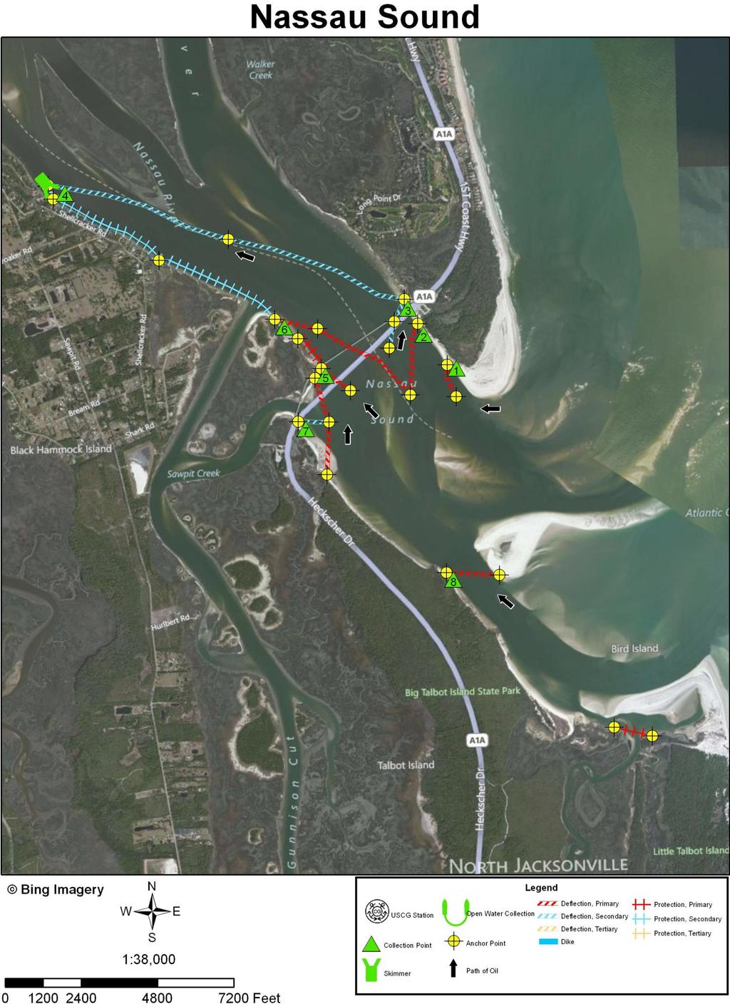
10 INLET SUMMARY SHEET SITE: Nassau Sound, Nassau and Duval Counties, Florida DATE AND TIME OF ORIGINAL FIELD SURVEY [TIDE]: 27 June 1994; (+5.8); Nassau River, entrance] UPDATED: In October 2011 using imagery collected in 2010 and RANKING (DEGREE OF DIFFICULTY): A. (see ranking scale) PRINCIPAL RESOURCES AT RISK: Extensive salt marsh system. Atlantic loggerhead turtles nest on outer beaches. Shorebirds, including the American oyster catcher; wading birds, including the Great egret and White ibis; and seabirds, including the Black skimmer, Least tern, Gull-billed tern, Sandwich tern, and Royal tern. Mounds of the Eastern oyster occur on the flats in several of the tidal channels. For further information consult recent ESI maps and data and the GRP. PRELIMINARY PROTECTION STRATEGY: Project a short limb of deflection boom out into the main inlet channel to deflect oil to the south end of Amelia Island (CP1). Anchor deflection boom in a Christmas tree configuration to the backside side of the sand shoal that occupies the central portion of the main inlet channel on the seaward side of the new route A1A Bridge. The northeast limb should divert oil to a collection point on the sand beach at the south end of Amelia Island (CP2). Position a limb of the deflection boom with its south end anchored in the middle of the main inlet channel a ways landward of the leading anchor point of the Christmas tree. This limb of boom would deflect oil to a sand beach created by a groin just beyond the northeast end of the A1A Bridge (CP3). Use a primary and secondary line of deflection boom to divert oil away from the mouth of Sawpit Creek. Any oil entraining the primary line of deflection boom is diverted by the secondary line of boom to the fine-grained sand beach on the east side of the new A1A Bridge abutment (CP7) on the southeast side of the main inlet channel A line of deflection boom should extend outside CP7 and the mouth of Sampit Creek. It is extended further under the new A1A Bridge to a sand beach (CP5), which is located where the old A1A Bridge used to go across the main inlet channel (along the 32
11 INLET SUMMARY SHEET SITE: Nassau Sound, Nassau and Duval Counties, Florida (continued) PRELIMINARY PROTECTION STRATEGY (continued): southeast side of the old A1A highway). From the point on the beach where the old A1A Bridge used to go across the main inlet channel, extend a limb of deflection boom out into the main inlet channel to divert oil to CP5. From the west side of the old bridge, place a line of protection boom (about 500 yards long) in a northwest direction to protect a salt marsh area along the side of the main inlet channel. A sand beach/tidal flat at the end of this line of boom is CP6. The south end of the Christmas tree in the main inlet channel also diverts oil to CP6. From CP6, extend a line of protection boom about 1.5 miles along the south side of the main inlet channel (and across the entrance to the ICW) and on into the Nassau River to a short line of deflection boom that connects to an open water skimmer (CP4). About 2.4 miles of deflection boom extends along the north side of the channel between CP3 and CP4. Establish a limb of deflection boom across the channel south of Bird Island to deflect oil to a sand beach (CP8) on the south side of the channel. CP8 is located about one mile southeast of CP7. This orientation is designed to take advantage of flood currents coming in along this channel. At about another mile southeast of CP8, place a line of protection boom across the mouth of a tidal creek to exclude oil from a salt marsh area. 33
12 34

13 Collection Point Description Inlet: Nassau Sound Site Name: Collection Point #1 Relative Location: South end of Amelia Island, GA. Latitude: 30 31' 0.655" N Shoreline Description: Fine-grained sand beach. Currents: Flood currents of up to 2 knots or more. Longitude: 81 26' " W Access: Along sand beach (probably from parking area near northeast end of A1A Bridge). May be difficult. Another option is to use watercraft. 35

14 Collection Point Description Inlet: Nassau Sound Site Name: Collection Point #2 Relative Location: South end of Amelia Island. Near northeast end of A1A Bridge. Latitude: 30 31' " N Shoreline Description: Fine-grained sand beach. Currents: Flood currents up to 2 knots or more. Longitude: 81 26' " W Access: On side of inlet near major parking area at northeast end of A1A Bridge. Excellent access. 36

15 Collection Point Description Inlet: Nassau Sound Site Name: Collection Point #3 Relative Location: South end of Amelia Island on the north side of the main inlet channel near a groin on a sand beach just on the northwest side of the old A1A Bridge. Latitude: 30 31' " N Shoreline Description: Fine-grained sand beach. Currents: Flood currents up to 2 knots or more. Longitude: 81 26' " W Access: Paved road under bridge from the parking area at northeast end of new A1A Bridge. Good access. 37

16 Collection Point Description Inlet: Nassau Sound Site Name: Collection Point #4; open water skimmer. Relative Location: In Nassau River channel about 2.4 miles landward of the new A1A Bridge. Latitude: 30 31' " N Longitude: 81 28' " W Shoreline Description: Open water skimmer. Currents: Over 2 knots to be expected. Access: By watercraft. 38

17 Collection Point Description Inlet: Nassau Sound Site Name: Collection Point #5 Relative Location: Near southeast end of old A1A Bridge. Latitude: 30 31' 0.828" N Shoreline Description: Fine-grained sand beach. Longitude: 81 27' " W Currents: Flood currents of at least 2 knots to be expected. Access: Near southeast end of the old A1A Bridge. Parking available at old boat ramp on north side of road. Good access. 39

18 Collection Point Description Inlet: Nassau Sound Site Name: Collection Point #6 Relative Location: Near entrance to ICW on the south side of the main inlet channel. Latitude: 30 31' " N Longitude: 81 27' " W Shoreline Description: Fine-grained sand beach / tidal flat. Currents: Flood currents up to 2 knots to be expected. Access: Only by watercraft. Difficult. 40

19 Collection Point Description Inlet: Nassau Sound Site Name: Collection Point #7 Relative Location: Just east of new A1A Bridge abutment, south side of main inlet channel. Latitude: 30 30' " N Longitude: 81 27' " W Water Depth Description: 4-5 depth 5 from bridge. Currents: 1-2 knots along shore, 3-4 knots in channel. Shoreline Description: Fine-grained sand. Access: Close to new highway A1A. Dirt-road leads from parking area to the south. 41

20 Collection Point Description Inlet: Nassau Sound Site Name: Collection Point #8 Relative Location: In Big Talbot Island State Park. Little over a mile southeast of the southwest end of the new A1A Bridge off Heckscher Drive. Latitude: 30 29' " N Shoreline Description: Fine-grained sand beach. Currents: Possibly up to a knot or so. Longitude: 81 26' " W Access: Some sandy tracks. Along beach at low tide (?). May be difficult, requiring use of watercraft. 42
Geographic Response Plan Map: SFL-41
 ! 400!!!! iscayne Bay Aquatic reserve ey X 25 22'30"N Map continued on: SFL-42 k Barnes Sound SFL42-01 FKNMS SFL-42 u Florida Keys ational Marine Sanctuary 25 15'0"N 80 22'30"W Environmentally Sensitive
Geographic Response Plan Map: SFL-31. Bradley. Map continued Key on: SFL-34. Key. Murray Key XXX SFL Clive Key XXX. SFL31-06 Clive Key
 ! 1550 1450 81 0'0"W # [\ m [] Geographic Response Plan Map: SFL-31 Bradley Map continued on: SFL-34 Jow Kemp Florida Bay 80 52'30"W 25 7'30"N 1550 1350 SFL31-01 Conchie Channel SFL31-02 Oyster Oyster
Geographic Response Plan Map: SC-56. Map Continued on SC-50 XXX. Fripps Inlet. Raptor Nesting Area. Recreational Fishing. Sea Turtles.
 32 22'30"N Map Continued on SC-55 80 30'0"W X ull et SC56-01 Story/Harbor River Junction Story River!h!S(!d Old House Creek 1050 [ 400 1000 SC56-03 Old House Creek «Geographic Response Plan Map: SC-56
Geographic Response Plan Map: SC-50. Map Continued on SC-42. St Helena Sound. SC50-04 Ashepoo River. Combahee. Bank
 Back -05 e Morgan Village Creek # 32 30'0"N Beaufort County Coosaw R Creeks Map Continued on SC-49 750 900 SC42-03 ICWW - 80 30'0"W Coosaw River iver 1050 1050 Coosaw River Morgan Back Creeks Village Creek
Geographic [x Response Plan Map: GA-12 [r. Map Continued on GA-8 XXX. GA12-01 Green Island Sound. OSSABAW ISLAND WMA Raccoon Key XXX
 Charles Ogeechee River tal Waterway 31 52'30"N Little Ogeechee River Harveys Island 81 7'30"W Charles Rush Charles 950 Ogeechee River Geographic Response Plan Map: GA-12 Map Continued on GA-8 Green Island
Geographic Response Plan Map: SC-42
 w Bowles SC41-07 New Chehaw 750! 80 30'0"W BASIN NERR 32 37'30"N Map Contined on SC-41 32 30'0"N Beafort Conty Coosaw R Ashepoo 80 30'0"W iver Legend Beet Coosaw [!d Crooked SC42-03 ICWW - Coosaw 650 Rock
Geographic Response Plan Map: GA-2. Raptor Nesting Area. Recreational Fishing. Sea Turtles. Shorebird Nesting Area. Wading birds Nesting Area
 81 7'30"W Geographic Response Plan Map: GA-2 81 0'0"W 32 15'0"N 32 15'0"N Union Creek «46 Jasper Beaufort «170 Sector Charleston Sava n nah «170 and 2 AH NATIONAL FE REFUGE Middle River GA1-07 Steam Boat
[ Gull/Tern Nesting Area
 33 30'0"N 79 15'0"W Geographic Response Plan Map: SC-10 Georgetown County Chapel Creek Tho roughfar e C reek Holly Hill 550 200 SC10-04 (tidal flats) 79 7'30"W Br ook g Sandhole Creek Oaks Island 33 30'0"N
Geographic [ Response Plan Map: GA-9. Map Continued on GA-5 FORT PULASKI. Shad River XXX. GA9-01 Lazaretto Creek West.
 of ake) rsh Creek s Creek!S(!d Chatham County!h Wilmington River Odingsell River D EFUGE 32 0'0"N Map Continued on GA-8 31 52'30"N 81 0'0"W 450 Odingsell River 350 Wilmington River Romerly Marsh Creek
1. Qualitative Assessment... II-101
 Table of Contents I. Introduction... I-1 A. Session Law 2009-479 / House Bill 709... I-2 B. Public Consultation... I-3 C. Selection of Study Sites... I-5 D. Limitations of Study... I-8 II. Physical Assessment...
Geographic Response Plan Map: GA-5. Map Continued on SC-58. Jones Island. GA5-01 River Break b/t North and South Channels - XXX.
 Creek 32 7'30"N 81 0'0"W Ramshorn Creek Geographic Response Plan Map: GA-5 New River Map Continued on SC-58 950 Intracoastal 100 350 Waterway 80 52'30"W 1000 32 7'30"N Daufus Pine New River GA4-09 West
Backcountry Management. Anne Morkill Wildlife Refuge Manager U.S. Fish & Wildlife Service
 Backcountry Management Anne Morkill Wildlife Refuge Manager U.S. Fish & Wildlife Service Florida Keys National Marine Sanctuary Advisory Council Duck Key, FL February 21, 2012 Overview of National Wildlife
Siletz Bay BCS number: 47-29
 Siletz Bay BCS number: 47-29 ***NOTE: We were unable to determine all necessary information for this site description. If you would like to contribute the needed information to this description, please
Stay Out Zones and Boom Priorities for Shorebirds in Franklin County
 Stay Out Zones and Boom Priorities for Shorebirds in Franklin County C All the Coastal Beaches that are Publically Owned (State and Federal) have use by nesting birds. These areas are posted. BMPs for
Matagorda Island Marsh Restoration An Adaptive Management Approach by Coastal Bend Bays & Estuaries Program
 Matagorda Island Marsh Restoration An Adaptive Management Approach by Coastal Bend Bays & Estuaries Program 1957: After Levees 1930: Before Levees Matagorda Island: Site Location Texas Coastal Bend Calhoun
State of New Jersey Chris Christie, Governor. Dept. of Environmental Protection Bob Martin, Commissioner
 Cape May Beach 2016/2017 Renourishment Cape May Inlet to Lower Township & Lower Cape May Meadows Cape May Point Cape May County, New Jersey New Jersey Department of Environmental Protection Engineering
Florida Keys National Wildlife Refuge Complex. Key West NWR Great White Heron NWR National Key Deer NWR Crocodile Lake NWR
 Florida Keys National Wildlife Refuge Complex Key West NWR Great White Heron NWR National Key Deer NWR Crocodile Lake NWR Key West NWR Marquesas Keys and 13 other keys Mission as a preserve and protect
Cat Island Chain Restoration Project Brown County Port & Resource Recovery Department
 Cat Island Chain Restoration Project Brown County Port & Resource Recovery Department February 2, 2015 Fox River and Lower Green Bay Cat Island Chain - 1938 Cat Island Brown County Aerial Photography,
Wilderness Lost. Cape Romain National Wildlife Refuge. South Carolina Lowcountry Refuge Complex
 Wilderness Lost Cape Romain National Wildlife Refuge South Carolina Lowcountry Refuge Complex Waccamaw NWR 22,859 Acres Santee NWR 12,483 Acres Cape Romain NWR 66,287 Acres Ernest F. Hollings ACE Basin
BookletChart. Chesapeake Bay Pocomoke and Tangier Sounds NOAA Chart A reduced-scale NOAA nautical chart for small boaters
 BookletChart Chesapeake Bay Pocomoke and Tangier Sounds NOAA Chart 12228 A reduced-scale NOAA nautical chart for small boaters When possible, use the full-size NOAA chart for navigation. Published by the
Expansion Work Has Begun The perimeter dike for Cell 7 is now visible
 Summer/Fall 2017 In This Issue Poplar Island Expansion Wetland Cell 5AB Development Wildlife Update Birding tours on Poplar Island Expansion Work Has Begun The perimeter dike for Cell 7 is now visible
Cape Romain National Wildlife Refuge Climate Change Impacts
 Climate Change Impacts How will the Refuge be Affected by Climate Change? Salt marsh fragmentation by rapidly eroding tidal creeks Salt marsh submergence during high tide events leading to habitat conversion
Lake Worth Lagoon Initiative Habitat Working Group September 11, :00pm 4:00pm
 Lake Worth Lagoon Initiative Habitat Working Group September 11, 2018 2:00pm 4:00pm Palm Beach County Environmental Resources Management 2300 North Jog Road 1 st Floor Vista Center 1E-60 West Palm Beach,
BookletChart. Intracoastal Waterway Grassy Key to Bahia Honda Key NOAA Chart A reduced-scale NOAA nautical chart for small boaters
 BookletChart Intracoastal Waterway Grassy Key to Bahia Honda Key NOAA Chart 11453 A reduced-scale NOAA nautical chart for small boaters When possible, use the full-size NOAA chart for navigation. Published
Coastal Wildlife Conservation Initiative
 Coastal Wildlife Conservation Initiative What is the Coastal Wildlife Conservation Initiative? A partnership strategy to address coastal issues that impact wildlife and their habitats USFWS CWCI Vision
Marine Corps Support Facility-Blount Island: Integrated Natural Resources Program Successes. E2S2 Conference May 12, 2011
 Marine Corps Support Facility-Blount Island: Integrated Natural Resources Program Successes E2S2 Conference May 12, 2011 Shari Kennedy, MCSF-BI Robert Price, CH2M HILL Location Mission The mission of Marine
Jackson Bottom Wetlands Preserve BCS Number: 47-14
 Jackson Bottom Wetlands Preserve BCS Number: 47-14 Site description author(s) Greg Gillson, Jackson Bottom Wetlands Preserve Primary contact for this site Ed Becker, Natural Resources Manager, Jackson
4-H Marine Biology and Oceanography Proficiency Program A Member s Guide
 4-H Marine Biology and Oceanography Proficiency Program A Member s Guide OVERVIEW The 4-H Marine Biology and Oceanography Proficiency program helps you learn what you need to know about your 4-H Marine
COASTAL MANAGEMENT ELEMENT
 COASTAL MANAGEMENT ELEMENT of the PINELLAS COUNTY COMPREHENSIVE PLAN Prepared By: The Pinellas County Planning Department as staff to the LOCAL PLANNING AGENCY for THE BOARD OF COUNTY COMMISSIONERS OF
United States Department of the Interior
 United States Department of the Interior Mickey T. Sugg Wilmington Regulatory Field Office U. S. Army Corps of Engineers 69 Darlington Ave. Wilmington, North Carolina 28403 FISH AND WILDLIFE SERVICE Raleigh
National Park Service Beach Access Report for July 31, 2008
 National Park Service U.S. Department of the Interior Outer Banks Group: Cape Hatteras National Seashore Fort Raleigh National Historic Site Wright Brothers National Memorial 1401 National Park Road Manteo,
National Audubon Society. Coastal Bird Conservation Program
 National Audubon Society Coastal Bird Conservation Program Coastal Bird Conservation Program This presentation contains original photos and data. For any use of this information, data, maps, or photographs
SENATE CONCURRENT RESOLUTION No. 158 STATE OF NEW JERSEY. 217th LEGISLATURE INTRODUCED JUNE 26, 2017
 SENATE CONCURRENT RESOLUTION No. STATE OF NEW JERSEY th LEGISLATURE INTRODUCED JUNE, 0 Sponsored by: Senator JEFF VAN DREW District (Atlantic, Cape May and Cumberland) Senator ROBERT M. GORDON District
Lake Worth Lagoon Initiative Habitat Working Group
 Lake Worth Lagoon Initiative Habitat Working Group April 5, 2018 10:00am 12:00pm AGENDA I. Introductions II. Business A. LWL Benthic Analysis at Fixed Transect Locations Cheryl Miller, Coastal Eco-Group
Rookery Island Clean Ups Remove 8,000 Pounds of Trash and Debris by Kathryn Tunnell
 Stay connected with The Edge: News and Updates from the Coastal Bend Bays & Estuaries Program News and Updates from the Coastal Bend Bays & Estuaries Program Visit Our Website Rookery Island Clean Ups
Picayune Strand Restoration Project in Southwest Florida A Landscape Perspective
 U.S. Fish and Wildlife Service Restoring America s Everglades-Recovering Multiple Species Picayune Strand Restoration Project in Southwest Florida A Landscape Perspective Kim Dryden U.S. Fish and Wildlife
U.S. Fish and Wildlife Service response to Climate Change. Bob Ford Deputy, SE Science Applications Program U.S. Fish and Wildlife Service
 U.S. Fish and Wildlife Service response to Climate Change Bob Ford Deputy, SE Science Applications Program U.S. Fish and Wildlife Service Sam Hamilton Southeast Regional Director, 1997-2009 U.S. Fish and
Offshore Drilling in the Atlantic January 2018
 Offshore Drilling in the Atlantic January 2018 Scientific evidence and history prove that drilling for oil and gas reserves off the Atlantic coast will unnecessarily imperil wildlife and threaten local
Erie County Van Trip. Pipe Creek Wildlife Area
 Erie County Van Trip ***See red markings on maps indicating the best birding options at each location. Please note that you are not limited to these areas, they are just the areas we feel will be most
APPENDIX M BIRD NESTING DATA ( )
") APPENDIX M BIRD NESTING DATA (1984-2011) Final Environmental Impact Statement Village of Bald Head Island Shoreline Protection Project Brunswick County, North Carolina Date Species Number of Birds Number
APPENDIX M BIRD NESTING DATA (1984-2011) Final Environmental Impact Statement Village of Bald Head Island Shoreline Protection Project Brunswick County, North Carolina Date Species Number of Birds Number
Oregon Dunes National Recreation Area BCS Number: 47-5
 Oregon Dunes National Recreation Area BCS Number: 47-5 ***NOTE: We were unable to determine all necessary information for this site description. If you would like to contribute the needed information to
Collaboration and Planning to Implement the South San Diego Bay Restoration and Enhancement Project
 Collaboration and Planning to Implement the South San Diego Bay Restoration and Enhancement Project Carolyn Lieberman Coastal Program Coordinator for Southern California U.S. Fish and Wildlife Service
Deer Island. a Sportsman s Paradise 90 +/- Acres 0.8 +/- Mile of Gulf of Mexico White Sand Beach 0.8 +/- Mile of Waterfront Facing the Mainland
 Deer Island a Sportsman s Paradise 90 +/- Acres 0.8 +/- Mile of Gulf of Mexico White Sand Beach 0.8 +/- Mile of Waterfront Facing the Mainland 2 Photos of Subject Property Deer Island A Sportsman s Paradise
Ladd Marsh Wildlife Area BCS number: 49-3
 Oregon Coordinated Aquatic Bird Monitoring: Description of Important Aquatic Bird Site Ladd Marsh Wildlife Area BCS number: 49-3 Site description author M. Cathy Nowak, Ladd Marsh Wildlife Area Biologist
McKay Creek National Wildlife Refuge BCS number: 48-19
 Oregon Coordinated Aquatic Bird Monitoring: Description of Important Aquatic Bird Site McKay Creek National Wildlife Refuge BCS number: 48-19 Site description author(s) Howard Browers, Supervisory Wildlife
Technical Memorandum ECO-7
 To: Woody Frossard, TRWD From: Bob Brashear, CDM This document is released for the purpose of interim review under the authority of Robert Brashear, P.E., TX license 80771 on 21-Mar-2005. It is not to
Environmental Protection
 Myakka Wild and Scenic River Program 2017 Annual Report 1 A. Permitting & Regulatory issues 1. Construction continues at the bridge replacement at C.R. 780. MRP030314 was issued to Sarasota County on March
Beach nesting birds ATLANTIC FLYWAY SHOREBIRD INITIATIVE
 Beach nesting birds ATLANTIC FLYWAY SHOREBIRD INITIATIVE Beach nesting birds Beach nesting birds Species Focal Species USSCP Status High Concern Estimated Population Population trend (30-year) American
Corps Dredge Plan 2016 Emily Hughes Env Resources, USACE BUILDING STRONG
 Corps Dredge Plan 2016 Emily Hughes Env Resources, USACE Goodbye Jeff Richter!! Navigation/Operations USACE Goal/Mission: To maintain safe Navigation in Federal Channels using methods that are most (1)
National Fish and Wildlife Foundation Executive Summary for the American Oystercatcher Business Plan
 National Fish and Wildlife Foundation Executive Summary for the American Oystercatcher Business Plan October 26, 2008 AMOY Exec Sum Plan.indd 1 8/11/09 5:24:00 PM Colorado Native Fishes Upper Green River
A Rising Tide: Conserving Shorebirds and Shorebird Habitat within the Columbia River Estuary
 A Rising Tide: Conserving Shorebirds and Shorebird Habitat within the Columbia River Estuary By Vanessa Loverti USFWS Migratory Birds and Habitat Programs, Portland, Oregon May 28, 2014 Outline of Talk
A View from the Gulf Coast: How Does All This Stuff Add Up?
 A View from the Gulf Coast: How Does All This Stuff Add Up? John Tirpak, PhD Science Coordinator, USFWS Gulf Restoration Program Lafayette, LA January 21, 2016 Mississippi River Basin/Gulf Hypoxia Initiative
Roberts Bank Terminal 2 Project Field Studies Information Sheet
 January 2013 Port Metro Vancouver is continuing field studies in January as part of ongoing environmental and technical work for the proposed. The is a proposed new multi berth container terminal which
Roberts Bank Terminal 2 Project Field Studies Information Sheet
 July 2012 Port Metro Vancouver is continuing field studies in July as part of ongoing environmental and technical work for the proposed Roberts Bank Terminal 2 Project. Roberts Bank Terminal 2 Project
Northeast Florida Coastal Wetland Restoration Program A Partnership Based Regional Approach for Estuary Habitat Restoration
 Northeast Florida Coastal Wetland Restoration Program A Partnership Based Regional Approach for Estuary Habitat Restoration Paul Haydt Restore America s Estuaries November 15, 2010 St Johns River Water
AERIAL SURVEY OF BIRDS AT MONO LAKE ON AUGUST 24, 1973
 AERIAL SURVEY OF BIRDS AT MONO LAKE ON AUGUST 24, 1973 by Ronald M. Jurek Special Wildlife Investigations Wildlife Management Branch California Department of Fish and Game September 1973 Jurek, R.M. 1973.
Resilient Birds, Devoted Advocates 2016 Coastal Bird Conservation Results. Spring American Oystercatcher Photo by Matt Filosa
 Resilient Birds, Devoted Advocates 2016 Coastal Bird Conservation Results Spring 2017 American Oystercatcher Photo by Matt Filosa Florida s coastal birds face long odds, but Audubon support gives them
Marine Mammal Response on the Texas Coast
 Marine Mammal Response on the Texas Coast SUBTITLE NMFS Permit 14450 Role of the Texas Marine Mammal Stranding Network in Response, Rehabilitation and Research Oil spill response, assessment and restoration:
MOTE NUUUNE LABORATORY MANATEE RESEARCH ACTIVITIES.
 MOTE NUUUNE LABORATORY MANATEE RESEARCH ACTIVITIES. First Progress Report: August 25, 2008 M MARINE LABORATORY Includes three reports: Photo-Identification Studies on Manatees in Southwestern Florida By:
Protecting Beach-nesting Birds in Louisiana VOLUNTEER TRAINING
 Protecting Beach-nesting Birds in Louisiana VOLUNTEER TRAINING How Many Bird Species in Louisiana? a. 120 b. 280 c. 480 Year-round Residents Nearctic-Neotropic Migrants W. Dave Patton Eric Liffmann Winter
Tahkenitch Creek Estuary BCS number: 47-35
 Tahkenitch Creek Estuary BCS number: 47-35 ***NOTE: We were unable to determine all necessary information for this site description. If you would like to contribute the needed information to this description,
Distribution of Piping Plover and Coastal Birds in Relation to Federal Activities on the Southern Coast of Long Island
 U.S. U.S. Fish Fish & Wildlife & Wildlife Service Service Distribution of Piping Plover and Coastal Birds in Relation to Federal Activities on the Southern Coast of Long Island Implications for Project
FWC Proposed CWA s in Southwest Florida Could Impact Boa;ng
 FWC Proposed CWA s in Southwest Florida Could Impact Boa;ng CWAs (Cri)cal Wildlife Area s) are established by FWC to protect important concentra)ons of wildlife and manage human ac)vi)es to minimize and
Upper Klamath National Wildlife Refuge Complex Upper Klamath Unit and Hank s Marsh Unit BCS Number: 48-29
 Oregon Coordinated Aquatic Bird Monitoring: Description of Important Aquatic Bird Site Upper Klamath National Wildlife Refuge Complex Upper Klamath Unit and Hank s Marsh Unit BCS Number: 48-29 Site description
Site Description: Gull Rock is located approximately 0.4 miles offshore and about six miles north of Yaquina Head in Lincoln County, Oregon.
 Devil s Punchbowl intertidal area Gull Rock (offshore) 12. Gull Rock Site Description: Gull Rock is located approximately 0.4 miles offshore and about six miles north of Yaquina Head in Lincoln County,
A volunteer-based program for the study of international migrations of shorebirds in the Western Hemisphere
 Estuary and inlet sandbars: an important wildlife resource Exemplified with counts from the International Shorebird Surveys Brian Harrington Manomet Center for Conservation Sciences The International Shorebird
Huguenot Memorial Park Federal Land Lease Renewal Jacksonville, Duval County, Florida
 Huguenot Memorial Park Federal Land Lease Renewal Jacksonville, Duval County, Florida Draft Environmental Assessment & Proposed Finding of No Significant Impact December 2012 This page intentionally left
PRE-TRIP ITINERARY Little St. Simons Island MAY 6-12, 2018
 Little St. Simons Lodge Cassie Wright PRE-TRIP ITINERARY Little St. Simons Island A SPECIAL NATURE CONSERVANCY DEPARTURE MAY 6-12, 2018 Estimated Price: $2550, per person double occupancy, $3495 per person
2/26/ % located in Collier, Lee, Monroe, Dade Ten Thousand Islands region Tampa Bay & Indian River Lagoon Largest mangrove forest in USA
 Mangroves Florida: 190,000 hectares of mangrove 90% located in Collier, Lee, Monroe, Dade Ten Thousand Islands region Tampa Bay & Indian River Lagoon Largest mangrove forest in USA Mangroves: tropical
Little St. Simons Island PRE-TRIP ITINERARY MAY 12-18, 2019 A SPECIAL NATURE CONSERVANCY DEPARTURE
 Little St. Simons Lodge Cassie Wright PRE-TRIP ITINERARY Little St. Simons Island A SPECIAL NATURE CONSERVANCY DEPARTURE MAY 12-18, 2019 Estimated Price: $2,700, per person double occupancy, $4,145 per
Red-breasted Merganser Minnesota Conservation Summary
 Credit Jim Williams Red-breasted Merganser Minnesota Conservation Summary Audubon Minnesota Spring 2014 The Blueprint for Minnesota Bird Conservation is a project of Audubon Minnesota written by Lee A.
Coos Bay BCS number: 47-8
 Coos Bay BCS number: 47-8 ***NOTE: The completion of this site description is still in progress by our Primary Contact (listed below). However, if you would like to contribute additional information to
Little St. Simons Island
 Little St. Simons Island A Special Departure with The Nature Conservancy s Legacy Club Marc Del Santro Itinerary Dates: May 4 10, 2014 Estimated Cost: $2150 based on Double Occupancy $2950 based on Single
Humboldt Bay NWR BCS number: 86-4
 Humboldt Bay NWR BCS number: 86-4 ***NOTE: We were unable to determine all necessary information for this site description. If you would like to contribute the needed information to this description, please
Origin and Distribution of American Oystercatchers. Wintering in Dixie, Levy and Citrus Counties
 Origin and Distribution of American Oystercatchers Wintering in Dixie, Levy and Citrus Counties Doris and Patrick Leary, Fernandina Beach AMOY Working Group Known & Unknown Aspects of Regional AMOY Population
Piping Plovers in Jamaica Bay
 Piping Plovers in Jamaica Bay Hanem Abouelezz, Biologist Jamaica Bay Unit Gateway National Recreation Area National Park Service Threatened and Endangered Species Our mission is to reduce the risk of
New Jersey Dept. of Environmental Protection Shore Protection Program
 New Jersey Dept. of Environmental Protection Benjamin Keiser, Manager 1510 Hooper Avenue, Suite 140 Toms River, New Jersey 08753 1-732-255-0767 New Jersey s State of New Jersey Chris Christie, Governor
Roberts Bank Terminal 2 Project Field Studies Information Sheet
 May 2013 Port Metro Vancouver is continuing field studies in May as part of ongoing environmental and technical work for the proposed Roberts Bank Terminal 2 Project. Roberts Bank Terminal 2 Project The
Economic Values Generated by the New Jersey Shore for Climate Change and Coastal Hazards Conference
 Economic Values Generated by the New Jersey Shore for Climate Change and Coastal Hazards Conference Professor Joseph J. Seneca Bloustein School of Planning and Public Policy, Rutgers University 25 May
Lake Worth Lagoon Initiative Habitat Working Group April 5, :00am 12:00pm
 Lake Worth Lagoon Initiative Habitat Working Group April 5, 2018 10:00am 12:00pm Palm Beach County Environmental Resources Management 2300 North Jog Road 1 st Floor Vista Center 1E-60 West Palm Beach,
Malheur National Wildlife Refuge BCS number: 48-18
 Oregon Coordinated Aquatic Bird Monitoring: Description of Important Aquatic Bird Site Malheur National Wildlife Refuge BCS number: 48-18 Site description author(s) Sally Hall, Volunteer, Malheur NWR Roger
Central California. 600,000 breeding seabirds + 8 million people (SF Bay Area) Potential for disturbance is high!
 Potential for disturbance is high!") Central California 600,000 breeding seabirds + 8 million people (SF Bay Area) -------------------------- Potential for disturbance is high! Overview Seabird Protection Network 2010 Accomplishments Expanding
Central California 600,000 breeding seabirds + 8 million people (SF Bay Area) -------------------------- Potential for disturbance is high! Overview Seabird Protection Network 2010 Accomplishments Expanding
LANZ AND COX ISLANDS PROVINCIAL PARK
 LANZ AND COX ISLANDS PROVINCIAL PARK PURPOSE STATEMENT AND ZONING PLAN March 2003 LANZ AND COX ISLANDS PROVINCIAL PARK Purpose Statement and Zoning Plan Primary Role The primary role of Lanz and Cox Islands
Sauvie Island Wildlife Area BCS number: 47-28
 Sauvie Island Wildlife Area BCS number: 47-28 Site description author(s) Mark Nebeker, Oregon Department of Fish and Wildlife, Sauvie Island Wildlife Area Manager Primary contact for this site Mark Nebeker,
2016 Breeding Season Guide MARCH 2016
 2016 Breeding Season Guide MARCH 2016 Events & reminders In this issue Events & reminders. 2 FSA news... 3 Pre-season planning checklist Posting nest sites Bird stewarding and outreach Breeding bird surveys
ENVIRONMENTAL SENSITIVITY INDEX: ST. JOHNS RIVER, FLORIDA
 ENVIRONMENTAL SENSITIVITY INDEX: ST. JOHNS RIVER, FLORIDA INTRODUCTION Environmental Sensitivity Index (ESI) maps have been developed for the St. Johns River, from Jacksonville south (upstream) to Sanford,
THE GULF COAST VULNERABILITY ASSESSMENT:
 THE GULF COAST VULNERABILITY ASSESSMENT: Amanda Watson GCVA Coordinator Mississippi State University Gulf Coast Prairie LCC June 3, 2015 Webinar Why? Changing Conditions Conservation is increasingly challenging
June 2018 Wrack Line Newsletter
 We only use cookies that are necessary for this site to function, and to provide you with the best experience. Learn more in our Cookie Statement. By continuing to use this site, you consent to the use
The Long Point Causeway: a history and future for reptiles. Scott Gillingwater
 The Long Point Causeway: a history and future for reptiles Scott Gillingwater Environmental Effects Long Point World Biosphere Reserve UNESCO designated the Long Point World Biosphere Reserve in April
Species: Birds (seabirds, shorebirds, waterfowl, raptors, passerines) and marine mammals
 and marine mammals") Circumnavigation surveys Wildlife Inventory Plan Alaska Maritime National Wildlife Refuge Protocol #22 Version 1.2 Parameter: Populations (and occasionally boom-or-bust productivity) Species: Birds (seabirds,
Circumnavigation surveys Wildlife Inventory Plan Alaska Maritime National Wildlife Refuge Protocol #22 Version 1.2 Parameter: Populations (and occasionally boom-or-bust productivity) Species: Birds (seabirds,
Oil Spill Response User Manual
 Oil Spill Response User Manual Seattle Audubon Puget Sound Seabird Survey August 2018 Contents Section 1: Oil Observations Reporting Guidance Introduction to the program. Section 2: Contact Information
Origin and Distribution of American Oystercatchers. Wintering in Dixie, Levy and Citrus Counties
 Pat and Doris Leary Origin and Distribution of American Oystercatchers Wintering in Dixie, Levy and Citrus Counties Doris and Patrick Leary, Fernandina Beach AMOY Working Group Known & Unknown Aspects
APPENDIX IV-C. Glades County Critical Facilities Vulnerability Analysis
 APPENDIX IV-C Glades County Critical Facilities Vulnerability Analysis CHAPTER IV REGIONAL VULNERABILITY AND POPULATION ANALYSIS This page intentionally left blank. TABLE OF CONTENTS A. Introduction...
LISS Habitat Restoration & Stewardship Workgroup Stewart B. McKinney Refuge 733 Old Clinton Rd Westbrook, CT May 1, 2018 Meeting Minutes
 LISS Habitat Restoration & Stewardship Workgroup Stewart B. McKinney Refuge 733 Old Clinton Rd Westbrook, CT 06498 May 1, 2018 Meeting Minutes Attendance-27 Juliana Barrett, CT Sea Grant Mike Bradley,
Ruddy Turnstone. Appendix A: Birds. Arenaria interpres [M,W] New Hampshire Wildlife Action Plan Appendix A Birds-50
![Ruddy Turnstone. Appendix A: Birds. Arenaria interpres [M,W] New Hampshire Wildlife Action Plan Appendix A Birds-50](/thumbs/89/101188544.jpg "Ruddy Turnstone. Appendix A: Birds. Arenaria interpres [M,W] New Hampshire Wildlife Action Plan Appendix A Birds-50") Ruddy Turnstone Arenaria interpres [M,W] Federal Listing State Listing Global Rank State Rank Regional Status N/A N/A G5 SNR Very High Photo by Pamela Hunt Justification (Reason for Concern in NH) Populations
Ruddy Turnstone Arenaria interpres [M,W] Federal Listing State Listing Global Rank State Rank Regional Status N/A N/A G5 SNR Very High Photo by Pamela Hunt Justification (Reason for Concern in NH) Populations
BIRD READING ASSIGNMENT
 Ocean Connectors BIRD READING ASSIGNMENT To do before the field trip, in class or at home 1. Students will read Wetland Neighbors. The reading is available on the next page and online at http://oceanconnectors.org/resources.
BookletChart. St. Joseph and Benton Harbor NOAA Chart A reduced-scale NOAA nautical chart for small boaters
 BookletChart St. Joseph and Benton Harbor NOAA Chart 14930 A reduced-scale NOAA nautical chart for small boaters When possible, use the full-size NOAA chart for navigation. Included Area Published by the
Ensuring habitat considerations in beach and shoreline management along Delaware Bay a bay wide perspective.
 Ensuring habitat considerations in beach and shoreline management along Delaware Bay a bay wide perspective. Kimberly B. Cole, David B. Carter, Tricia K. Arndt Delaware Coastal Programs Delaware Bay Coastal
9:40-10:00: Summary of route surveys conducted by FSA in 2014 in Volusia County
 Volusia Shorebird Partnership Pre-Season Meeting Minutes Monday March 16, 2015, 9:30-12:00 p.m. Beach Safety Headquarters, 3 rd floor conference room 515 S. Atlantic Ave. Daytona Beach, FL Meeting Agenda
Michael Rikard/CALO/NPS Thayer Jon Jerald
 0025457 From: To: Cc: Subject: Date: Attachments: Thayer Broili Tyler Bogardus; Britta Muiznieks Mike Murray; Darrell Echols Fw: Experimental Fence Research/Demonstration for CWB Protection at Bodie Island