BookletChart. St. Joseph and Benton Harbor NOAA Chart A reduced-scale NOAA nautical chart for small boaters
|
|
|
- Donald Howard
- 5 years ago
- Views:
Transcription


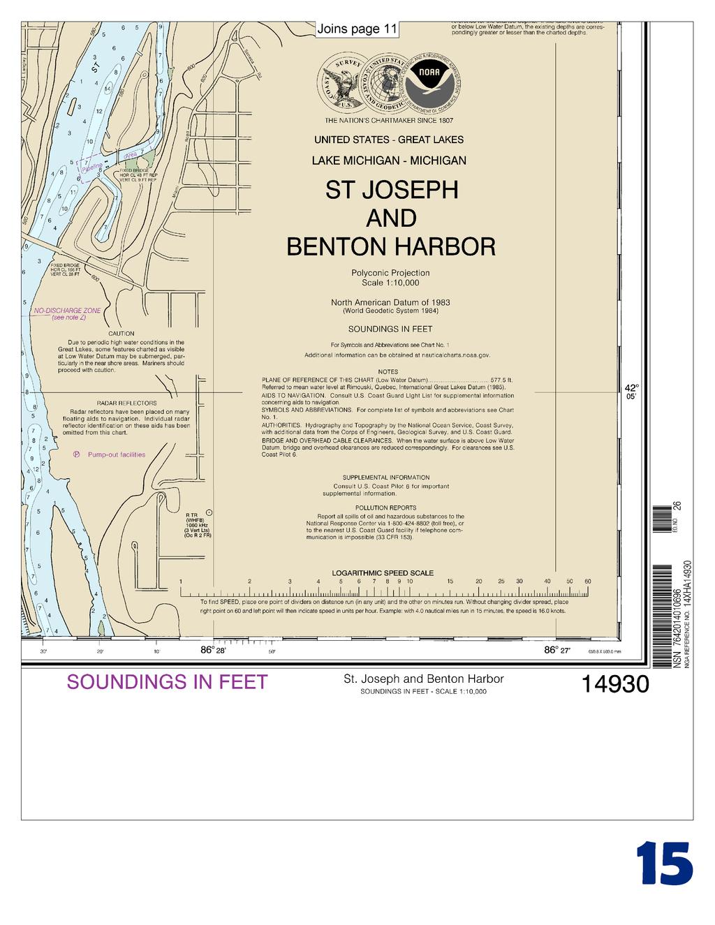
1 BookletChart St. Joseph and Benton Harbor NOAA Chart A reduced-scale NOAA nautical chart for small boaters When possible, use the full-size NOAA chart for navigation. Included Area

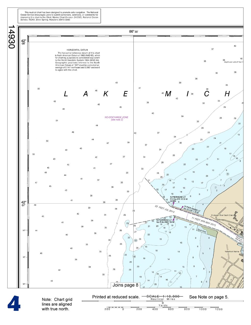
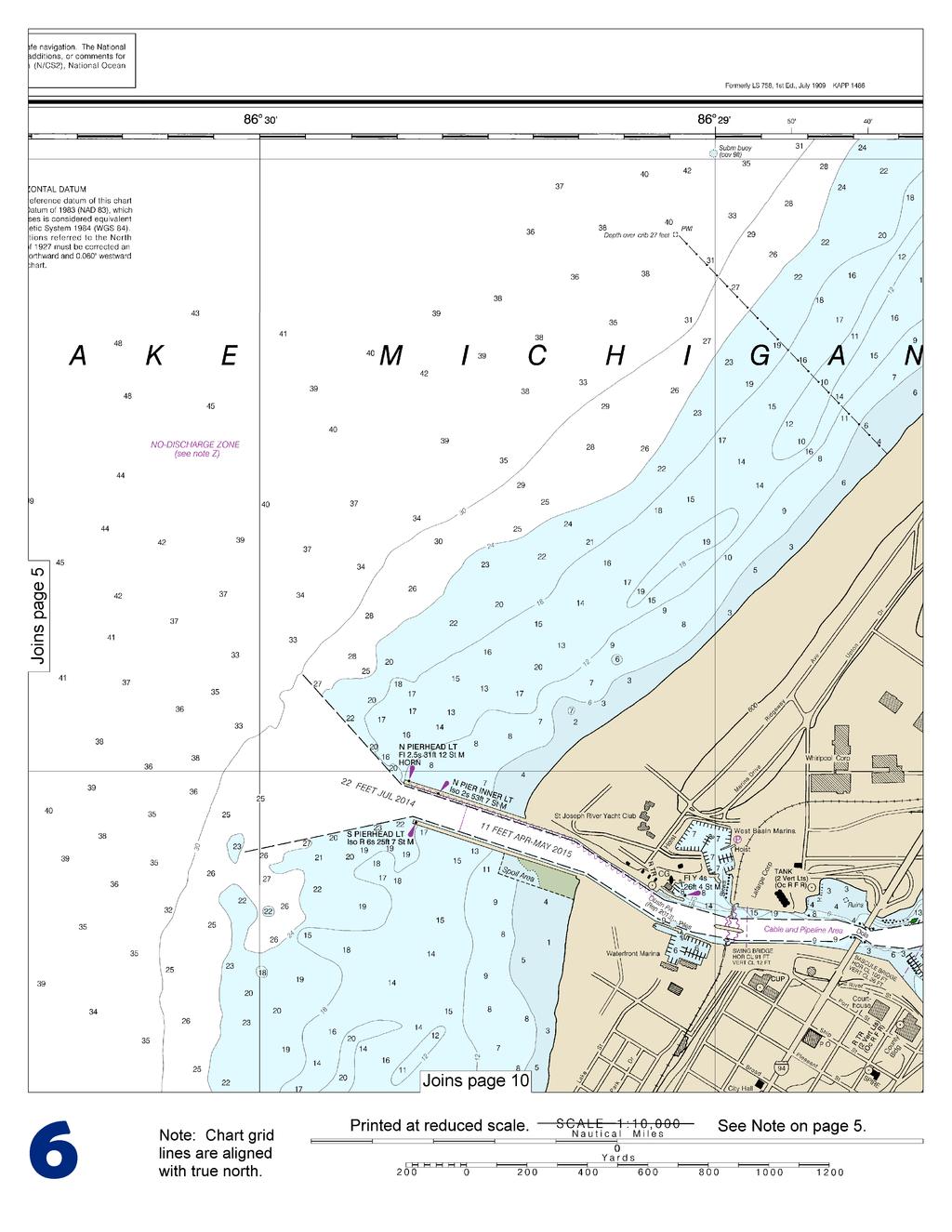
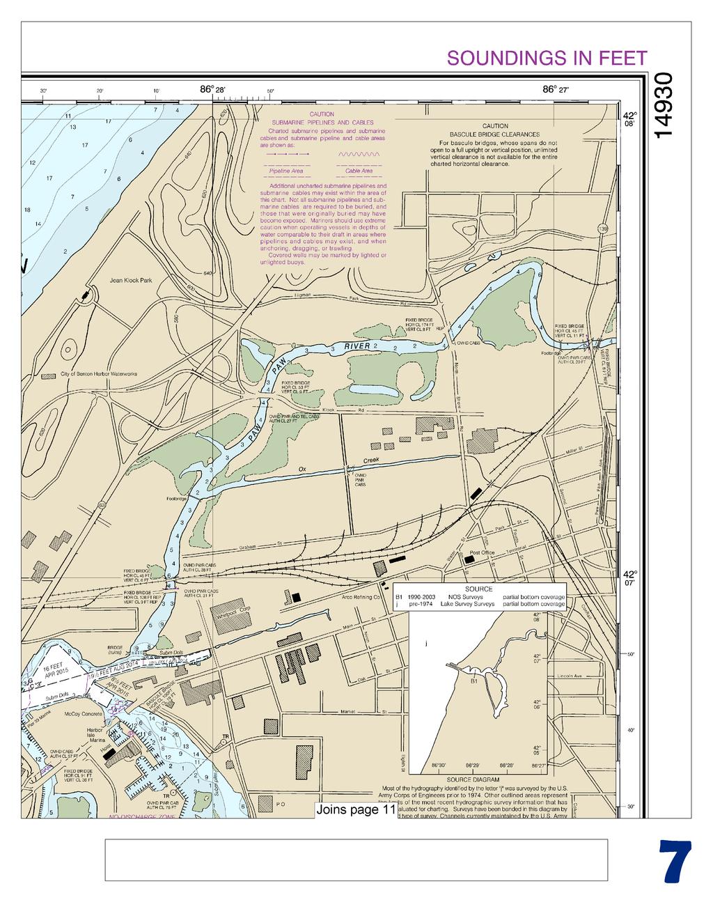
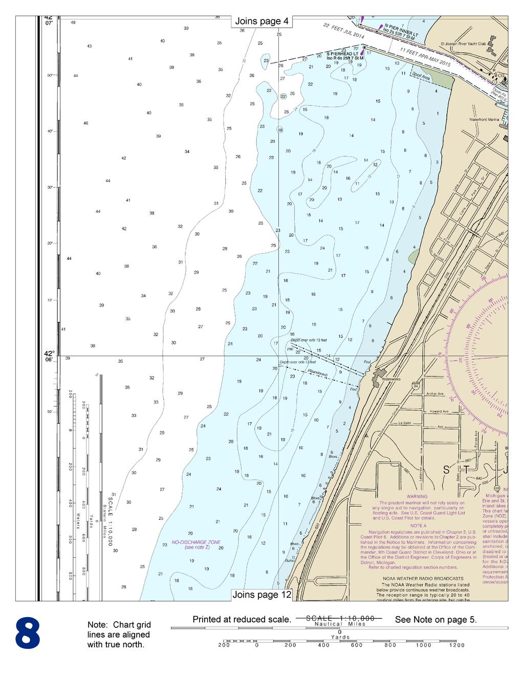
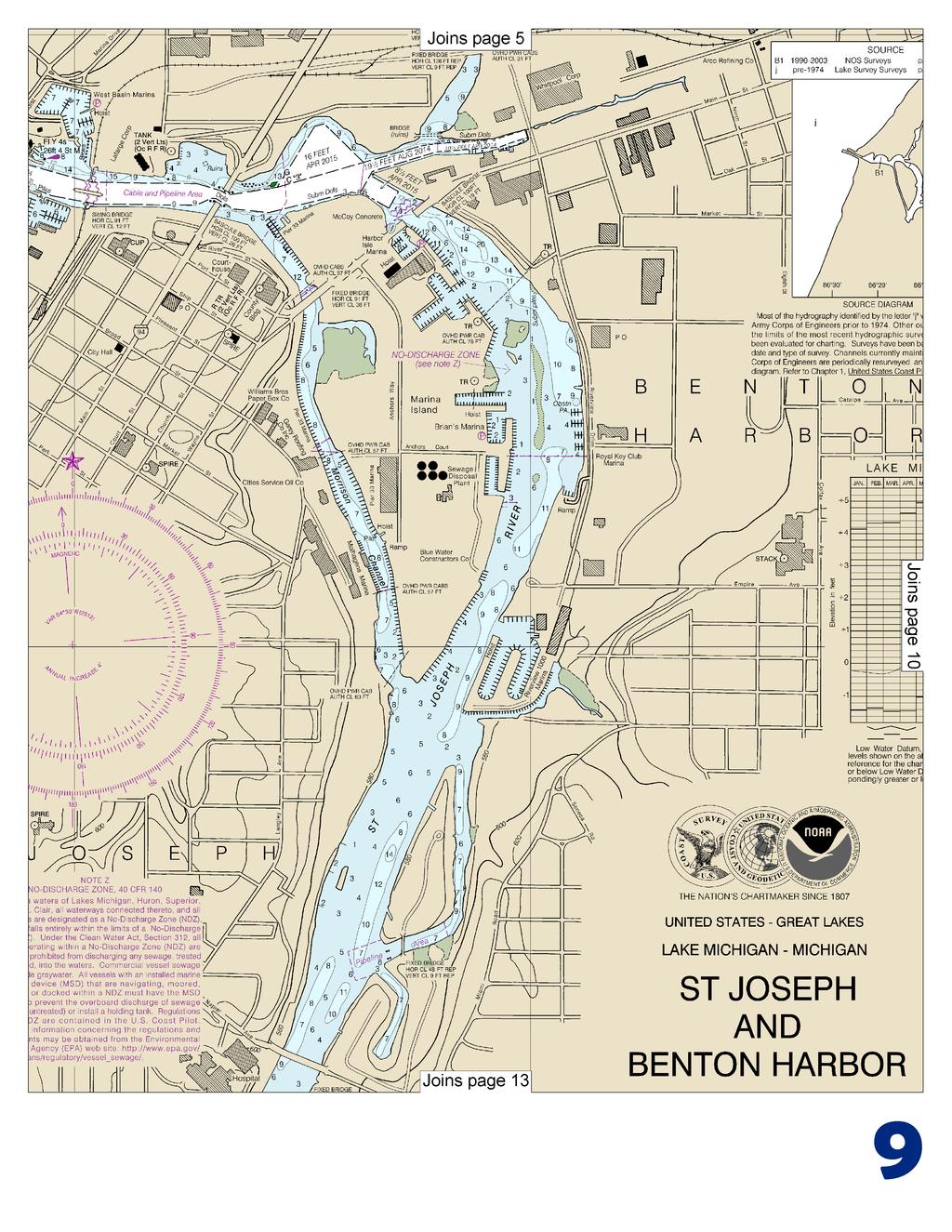
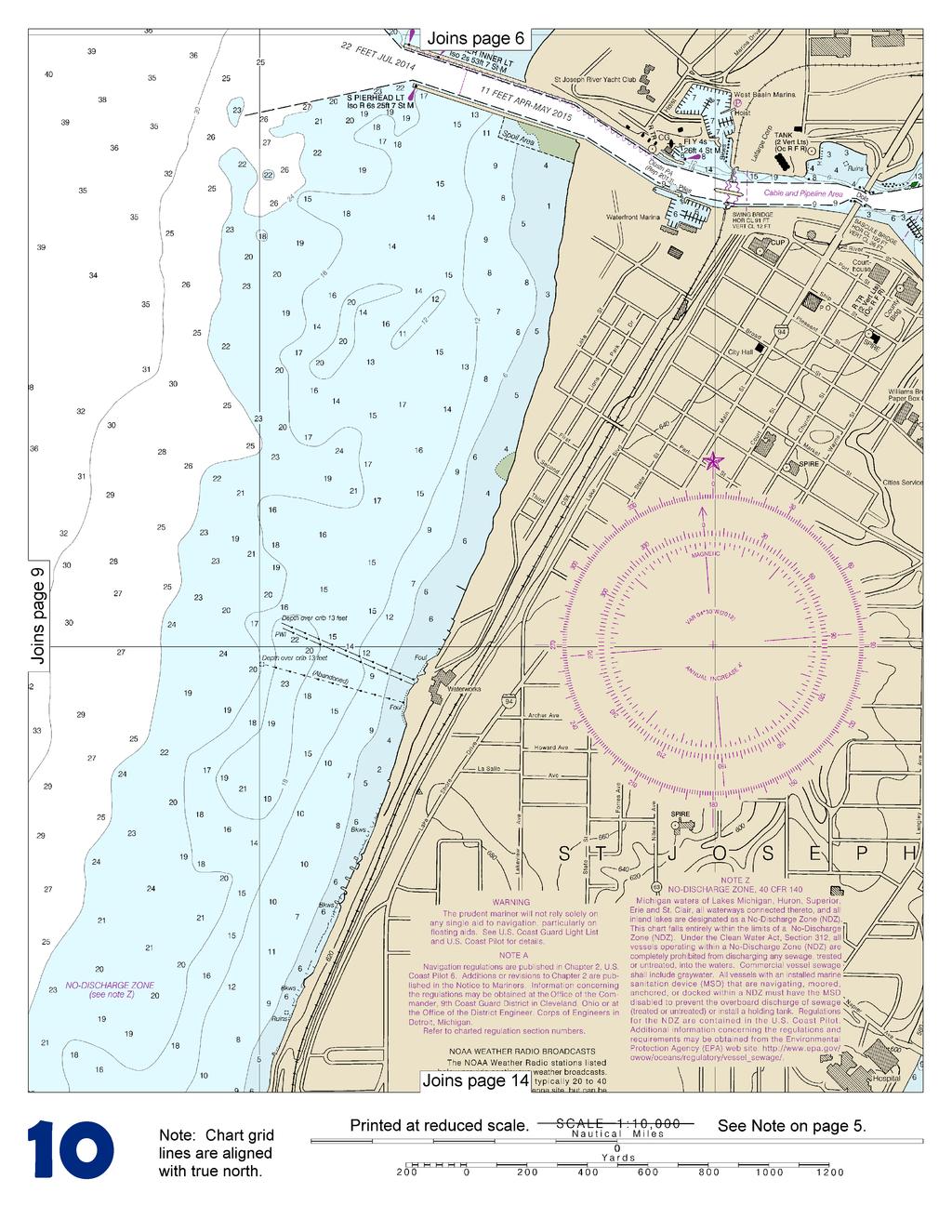
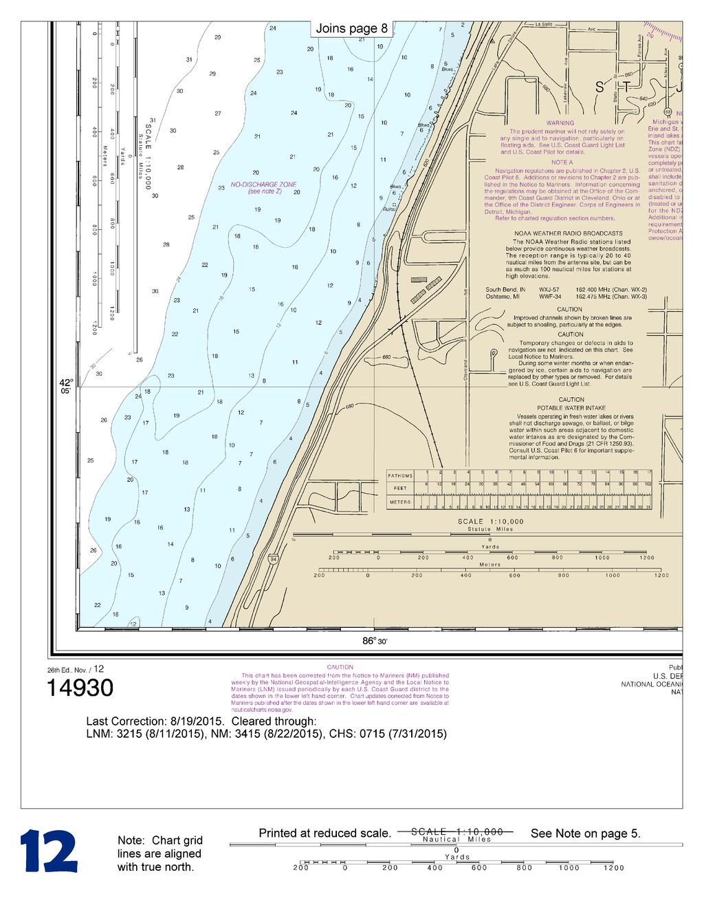
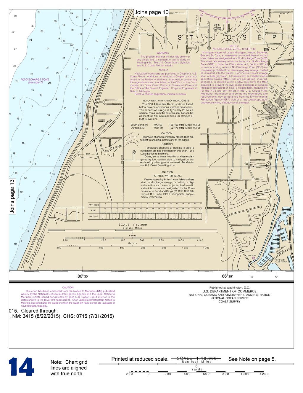
2 Published by the National Oceanic and Atmospheric Administration National Ocean Service Office of Coast Survey NOAA What are Nautical Charts? Nautical charts are a fundamental tool of marine navigation. They show water depths, obstructions, buoys, other aids to navigation, and much more. The information is shown in a way that promotes safe and efficient navigation. Chart carriage is mandatory on the commercial ships that carry America s commerce. They are also used on every Navy and Coast Guard ship, fishing and passenger vessels, and are widely carried by recreational boaters. What is a BookletChart? This BookletChart is made to help recreational boaters locate themselves on the water. It has been reduced in scale for convenience, but otherwise contains all the information of the full-scale nautical chart. The bar scales have also been reduced, and are accurate when used to measure distances in this BookletChart. See the Note at the bottom of page 5 for the reduction in scale applied to this chart. Whenever possible, use the official, full scale NOAA nautical chart for navigation. Nautical chart sales agents are listed on the Internet at This BookletChart does NOT fulfill chart carriage requirements for regulated commercial vessels under Titles 33 and 44 of the Code of Federal Regulations. Notice to Mariners Correction Status This BookletChart has been updated for chart corrections published in the U.S. Coast Guard Local Notice to Mariners, the National Geospatial Intelligence Agency Weekly Notice to Mariners, and, where applicable, the Canadian Coast Guard Notice to Mariners. Additional chart corrections have been made by NOAA in advance of their publication in a Notice to Mariners. The last Notices to Mariners applied to this chart are listed in the Note at the bottom of page 7. Coast Pilot excerpts are not being corrected. Channels. A dredged entrance channel leads from deep water in Lake Michigan between parallel piers through the mouth of St. Joseph River upstream for about 1 mile to the junction with Paw Paw River. The outer ends of the piers are marked by lights and the north pier has an inner light. The Federal project depths for the dredged channels in the harbor are 21 feet in the entrance and through the harbor to the junction with the Paw Paw River, thence 18 feet in the remainder of the channel to the head of the project at Riverview Drive. Turning basins on the north side of the channel just below the junction with the Paw Paw River and on the southeast side of the channel below the Twin Cities Bicentennial Bridge have project depths of 18 feet. (See Notice to Mariners and latest edition of charts for controlling depths.) Currents in the river attain velocities up to 3 mph. Navigation should not be attempted close to the piers due to stone riprap. Mooring to the piers and revetments is prohibited. Above the dredged channel, the St. Joseph River turns south and flows between St. Joseph on the W bank and the city of Benton Harbor on the east bank. In 1980, this reach had depths of 6 to 20 feet in the best channel, generally near the east bank. Small islands near midstream in this reach are sometimes submerged during high water conditions. Depths of 2 to 3 feet can be carried for about 7 miles above St. Joseph. The river is obstructed by dams at Berrien Springs, about 22 miles above St. Joseph. Morrison Channel cuts across the south turn in the St. Joseph River leaving the river about 1 mile above the pierheads and rejoining it about 2.5 miles above the pierheads. The channel is separated from the river channel by Marina Island. In 1971, Morrison Channel had a centerline controlling depth of 6 feet. Above the dredged channel in the Paw Paw River, the crooked channel is navigable by small craft for about 2 miles to the Paw Paw Avenue bridge. In 1968, the centerline controlling depth was 1 foot. Coast Guard. St. Joseph Coast Guard Station, marked by a light, is near the inner end of the north pier. Harbor regulations. A speed limit of 8 mph (7 knots) is enforced in the harbor. (See 33 CFR , chapter 2, for regulations.) Harbor regulations for the city of St. Joseph are enforced by the harbormaster and copies may be obtained from City Manager, City Hall, City of St. Joseph, St. Joseph, MI Harbor regulations for the city of Benton Harbor are enforced by the harbormaster, who is the chief of police. Copies of the regulations may be obtained from the Chief of Police, 200 Wall Street, Benton Harbor, MI For latest Coast Pilot excerpt visit the Office of Coast Survey website at (Selected Excerpts from Coast Pilot) The St. Joseph River flows into Lake Michigan 22 miles south-southwest of South Haven and 107 miles south of Little Sable Point. The port cities of St. Joseph, MI, and Benton Harbor, MI, are on the W and east sides of the river, respectively. The principal commodities handled in the harbor are gravel and cement. St. Joseph North Pierhead Light (42 06'55"N., 86 29'44"W.) is shown from a white cylindrical tower on the outer end of the south pier. A sound signal at the light is activated by keying the microphone five times on VHF-FM channel U.S. Coast Guard Rescue Coordination Center 24 hour Regional Contact for Emergencies RCC Cleveland Commander 9th CG District (216) Cleveland, OH
3 Navigation Managers Area of Responsibility Northwest and Pacific Islands Crescent Moegling Great Lakes Region Thomas Loeper Northeast Lt. Meghan McGovern Chesapeake and Delaware Bay Steve Soherr California Gerald Wheaton Mid-Atlantic Lt. Cmdr. Denise Gruccio Alaska Lt. Timothy M. Smith Western Gulf Coast Alan Bunn Central Gulf Coast Tim Osborn Southeast Kyle Ward South Florida Puerto Rico U.S. Virgin Islands Michael Henderson NOAA s navigation managers serve as ambassadors to the maritime community. They help identify navigational challenges facing professional and recreational mariners, and provide NOAA resources and information for safe navigation. For additional information, please visit nauticalcharts.noaa.gov/service/navmanagers To make suggestions or ask questions online, go to nauticalcharts.noaa.gov/inquiry. To report a chart discrepancy, please use ocsdata.ncd.noaa.gov/idrs/discrepancy.aspx. Lateral System As Seen Entering From Seaward on navigable waters except Western Rivers PORT SIDE ODD NUMBERED AIDS PREFERRED CHANNEL NO NUMBERS MAY BE LETTERED PREFERRED CHANNEL NO NUMBERS MAY BE LETTERED STARBOARD SIDE EVEN NUMBERED AIDS GREEN LIGHT ONLY PREFERRED CHANNEL TO STARBOARD PREFERRED CHANNEL TO PORT RED LIGHT ONLY FLASHING (2) TOPMOST BAND GREEN TOPMOST BAND RED FLASHING (2) FLASHING FLASHING OCCULTING GREEN LIGHT ONLY RED LIGHT ONLY OCCULTING QUICK FLASHING QUICK FLASHING ISO COMPOSITE GROUP FLASHING (2+1) COMPOSITE GROUP FLASHING (2+1) ISO 1 LIGHT 9 "1" Fl G 6s G C "1" 9 LIGHTED BUOY 5 G "9" Fl G 4s G "5" U A GR "U" GR "A" Fl (2+1) G 6s S CAN DAYBEACON CAN NUN NUN GR C "S" C RG "B" Fl (2+1) R 6s RG N "C" B G RG "G" 2 LIGHT 6 "2" Fl R 6s R N "6" 8 LIGHTED BUOY 2 DAYBEACON R "8" Fl R 4s R "2" For more information on aids to navigation, including those on Western Rivers, please consult the latest USCG Light List for your area. These volumes are available online at
4

5
6
7
8
9
10

11
12

13
14
15


16 VHF Marine Radio channels for use on the waterways: Channel 6 Inter-ship safety communications. Channel 9 Communications between boats and ship-to-coast. Channel 13 Navigation purposes at bridges, locks, and harbors. EMERGENCY INFORMATION Channel 16 Emergency, distress and safety calls to Coast Guard and others, and to initiate calls to other vessels. Contact the other vessel, agree to another channel, and then switch. Channel 22A Calls between the Coast Guard and the public. Severe weather warnings, hazards to navigation and safety warnings are broadcast here. Channels 68, 69, 71, 72 and 78A Recreational boat channels. Getting and Giving Help Signal other boaters using visual distress signals (flares, orange flag, lights, arm signals); whistles; horns; and on your VHF radio. You are required by law to help boaters in trouble. Respond to distress signals, but do not endanger yourself. Distress Call Procedures Make sure radio is on. Select Channel 16. Press/Hold the transmit button. Clearly say: MAYDAY, MAYDAY, MAYDAY. Also give: Vessel Name and/or Description; Position and/or Location; Nature of Emergency; Number of People on Board. Release transmit button. Wait for 10 seconds If no response Repeat MAYDAY call. HAVE ALL PERSONS PUT ON LIFE JACKETS! NOAA Weather Radio All Hazards (NWR) is a nationwide network of radio stations broadcasting continuous weather information directly from the nearest National Weather Service office. NWR broadcasts official Weather Service warnings, watches, forecasts and other hazard information 24 hours a day, 7 days a week. Quick References Nautical chart related products and information - Interactive chart catalog - Report a chart discrepancy - Chart and chart related inquiries and comments - Chart updates (LNM and NM corrections) - QR Coast Pilot online - Tides and Currents - Marine Forecasts - National Data Buoy Center - NowCoast web portal for coastal conditions - National Weather Service - National Hurrican Center - Pacific Tsunami Warning Center - Contact Us - For the latest news from Coast Survey, This Booklet chart has been designed for duplex printing (printed on front and back of one sheet). If a duplex option is not available on your printer, you may print each sheet and arrange them back-to-back to allow for the proper layout when viewing. NOAA s Office of Coast Survey The Nation s Chartmaker
BookletChart. Sacramento River Sacramento to Fourmile Bend NOAA Chart A reduced-scale NOAA nautical chart for small boaters
 BookletChart Sacramento River Sacramento to Fourmile Bend NOAA Chart 18664 A reduced-scale NOAA nautical chart for small boaters When possible, use the full-size NOAA chart for navigation. Included Area
BookletChart. Island of O ahu NOAA Chart A reduced-scale NOAA nautical chart for small boaters
 BookletChart Island of O ahu NOAA Chart 19357 A reduced-scale NOAA nautical chart for small boaters When possible, use the full-size NOAA chart for navigation. Included Area Published by the National Oceanic
BookletChart. Chesapeake Bay Pocomoke and Tangier Sounds NOAA Chart A reduced-scale NOAA nautical chart for small boaters
 BookletChart Chesapeake Bay Pocomoke and Tangier Sounds NOAA Chart 12228 A reduced-scale NOAA nautical chart for small boaters When possible, use the full-size NOAA chart for navigation. Published by the
BookletChart. Sacramento River Andrus Island to Sacramento NOAA Chart A reduced-scale NOAA nautical chart for small boaters
 BookletChart Sacramento River Andrus Island to Sacramento NOAA Chart 18662 A reduced-scale NOAA nautical chart for small boaters When possible, use the full-size NOAA chart for navigation. Included Area
BookletChart. Intracoastal Waterway Grassy Key to Bahia Honda Key NOAA Chart A reduced-scale NOAA nautical chart for small boaters
 BookletChart Intracoastal Waterway Grassy Key to Bahia Honda Key NOAA Chart 11453 A reduced-scale NOAA nautical chart for small boaters When possible, use the full-size NOAA chart for navigation. Published
BookletChart. Port-au-Prince (Haiti) NGA Chart A reduced-scale NGA nautical chart for small boaters
 NGA Chart A reduced-scale NGA nautical chart for small boaters") BookletChart Port-au-Prince (Haiti) NGA Chart 26186 A reduced-scale NGA nautical chart for small boaters When possible, use the full-size NGA chart or Electronic Nautical Chart (ENC) for navigation. VHF
BookletChart Port-au-Prince (Haiti) NGA Chart 26186 A reduced-scale NGA nautical chart for small boaters When possible, use the full-size NGA chart or Electronic Nautical Chart (ENC) for navigation. VHF
Passages Between Acklins Island, Haiti and Caicos Islands NGA Chart A reduced-scale NGA nautical chart for small boaters
 BookletChart Passages Between Acklins Island, Haiti and Caicos Islands NGA Chart 26260 A reduced-scale NGA nautical chart for small boaters When possible, use the full-size NGA chart or Electronic Nautical
BookletChart. Cap-Haitien NGA Chart A reduced-scale NGA nautical chart for small boaters
 BookletChart Cap-Haitien NGA Chart 26146 A reduced-scale NGA nautical chart for small boaters When possible, use the full-size NGA chart or Electronic Nautical Chart (ENC) for navigation. VHF Marine Radio
Baie de L Acul and Approaches (Haiti) NGA Chart A reduced-scale NGA nautical chart for small boaters
 NGA Chart A reduced-scale NGA nautical chart for small boaters") BookletChart Baie de L Acul and Approaches (Haiti) NGA Chart 26148 A reduced-scale NGA nautical chart for small boaters When possible, use the full-size NGA chart or Electronic Nautical Chart (ENC) for
BookletChart Baie de L Acul and Approaches (Haiti) NGA Chart 26148 A reduced-scale NGA nautical chart for small boaters When possible, use the full-size NGA chart or Electronic Nautical Chart (ENC) for
BookletChart. Approaches to Cap-Haitien and Bahia de Monti Cristi NGA Chart A reduced-scale NGA nautical chart for small boaters
 BookletChart Approaches to Cap-Haitien and Bahia de Monti Cristi NGA Chart 26142 A reduced-scale NGA nautical chart for small boaters When possible, use the full-size NGA chart or Electronic Nautical Chart
PROVIDING KNOWLEDGE AND KNOWHOW... ANYTIME, ANYWHERE LIGHT LIST. Reference Materials. Digital Edition. Captain Robert L. Figular
 PROVIDING KNOWLEDGE AND KNOWHOW... ANYTIME, ANYWHERE LIGHT LIST Reference Materials Digital Edition Captain Robert L. Figular Page intentionally left blank LIGHT LIST Atlantic Coast of North America MLS
SUMMARY: The Coast Guard is declaring Sea Area A1 in certain. areas off the coast of the United States based upon the
 DEPARTMENT OF HOMELAND SECURITY Coast Guard [Docket No. USCG-2015-0002] Declaration of Sea Area A1 ACTION: Notice. This document is scheduled to be published in the Federal Register on 01/20/2015 and available
Standard Operating Procedures for: VHF Marine Radio
 Serenity Houseboat I. Overview Standard Operating Procedures for: VHF Marine Radio VHF, or Very High Frequency, marine radio is the standard method of communication between vessels. Marine radio equipment
PRODUCTS AND SERVICES FOR THE MARITIME COMMUNITY. Ed Martin, Chief Customer Affairs Branch Navigation Services Division Monday, 27 October, 2008
 PRODUCTS AND SERVICES FOR THE MARITIME COMMUNITY Ed Martin, Chief Customer Affairs Branch Navigation Services Division Monday, 27 October, 2008 Coral Reef Conservation International Collaboration Marine
SECTION III NM 50/12 MARINE INFORMATION NOAA CHART NEW EDITIONS AND THEIR AVAILABILITY
 SECTION III NM 50/12 MARINE INFORMATION NOAA CHART NEW EDITIONS AND THEIR AVAILABILITY NOAA recognizes two paper nautical chart products: - the Print-on-Demand (POD) chart distributed by OceanGrafix (www.oceangrafix.com),
LT Matthew Forney, NOAA Navigation Manager Alaska Region Bering Strait MaritimeSymposium. Office of Coast Survey
 NOAA LT Matthew Forney, NOAA Navigation Manager Alaska Region Bering Strait MaritimeSymposium Who is Coast Survey? First science agency of the U.S. Formed in 1807 Responsible for surveying 3.4 million
NOAA Navigation Services Update
 NOAA Navigation Services Update Captain Jim Crocker Chief, Navigation Services Division NOAA s More than Two Centuries of Service First U.S. gov t science agency President Thomas Jefferson created the
SECTION III NM 34/14 MARINE INFORMATION
 MARINE INFORMATION AREAS TO BE AVOIDED (OCEANOGRAPHIC MOORINGS) IN THE EQUATORIAL PACIFIC OCEAN The National Oceanic and Atmospheric Administration (NOAA) maintains various buoys in the Equatorial Pacific
SECTION III NM 15/12 MARINE INFORMATION
 SECTION III NM 15/12 MARINE INFORMATION CHANGES TO BROADCAST OF WEATHER FORECASTS FOR THE OFFSHORE SOUTHWEST NORTH ATLANTIC, CARIBBEAN, AND GULF OF MEXICO Effective Tuesday April 03, 2012 at 2:00 pm Eastern
National Maritime Center
 National Maritime Center Providing Credentials to Mariners (Sample Examination) Page 1 of 6 Choose the best answer to the following Multiple Choice Questions. 1. The following questions are based on Chart
NOAA s National Ocean Service / Office of Coast Survey
 Coast Survey OCS 1807 2007 Maintains over 1000 nautical charts & 9 Coast Pilots Surveys over 3.4M SNM of oceans and lakes Conducts research and development in hydrography Thomas Jefferson Founder of The
Drawbridge Operation Regulation; Oakland Inner Harbor, ACTION: Notice of deviation from drawbridge regulation.
 This document is scheduled to be published in the Federal Register on 03/06/2015 and available online at http://federalregister.gov/a/2015-05231, and on FDsys.gov 9110-04-P DEPARTMENT OF HOMELAND SECURITY
(P.27)
") (P.27) 27 7 210 120 8 * Navigation and Anchoring Prohibited Area has been changed since June, 2017. 9 Port of Osaka The Guidelines of Measures for preventing Typhoon Disaster ( Objective )
(P.27) 27 7 210 120 8 * Navigation and Anchoring Prohibited Area has been changed since June, 2017. 9 Port of Osaka The Guidelines of Measures for preventing Typhoon Disaster ( Objective )
No MARCH 2014 UNITED STATES OF AMERICA. Contents
 10 8 MARCH 2014 UNITED STATES OF AMERICA Published Weekly by the National Geospatial-Intelligence Agency Prepared Jointly with the National Ocean Service and U.S. Coast Guard Contents Section I Chart Corrections............................................
The Future in Marine Radio Communication GMDSS. Department of Transportation United States Coast Guard
 The Future in Marine Radio Communication GMDSS Department of Transportation United States Coast Guard Do you use a Maritime Radio System? If so, the new Global Maritime Distress and Safety System (GMDSS)
SECTION III NM 17/15 MARINE INFORMATION
 SECTION III NM 17/15 MARINE INFORMATION NOAA CHART NEW EDITIONS AND THEIR AVAILABILITY NOAA produces nautical chart products to support Federal chart carriage requirements. These nautical charts are available
How Automatic Identification System (AIS) Is Being Used to Improve Navigation Safety Lock Operations Management Application Michael Winkler
 Is Being Used to Improve Navigation Safety Lock Operations Management Application Michael Winkler") How Automatic Identification System (AIS) Is Being Used to Improve Navigation Safety Lock Operations Management Application Michael Winkler June 2016 LOMA system overview USCG AIS data capabilities: AIS
How Automatic Identification System (AIS) Is Being Used to Improve Navigation Safety Lock Operations Management Application Michael Winkler June 2016 LOMA system overview USCG AIS data capabilities: AIS
DOWNLOAD OR READ : THE NAUTICAL CHART PDF EBOOK EPUB MOBI
 DOWNLOAD OR READ : THE NAUTICAL CHART PDF EBOOK EPUB MOBI Page 1 Page 2 the nautical chart the nautical chart pdf the nautical chart NOAA ENCs (ENC): Vector files of chart features and available in S-57
MARITIME SAFETY INFORMATION
 Introduction 1. Maritime Safety Information (MSI) is defined as navigational and meteorological warnings, meteorological forecasts, and other urgent safety-related messages. This information is of vital
SECTION III NM 40/17 MARINE INFORMATION
 SECTION III NM 40/17 MARINE INFORMATION NEW EDITION OF COAST PILOT U.S. Coast Pilot 4, Atlantic Coast: Cape Henry, VA to Key West, FL, forty-ninth edition, 2017, has been issued and is ready for free download
SECTION III NM 24/15 MARINE INFORMATION
 SECTION III NM 24/15 MARINE INFORMATION NATIONAL GEOSPATIAL-INTELLIGENCE AGENCY'S (NGA) GUIDANCE ON THE PROPER DISPLAY SCALE OF DIGITAL NAUTICAL CHART (DNC) DATA The DNC portfolio was originally created
GMDSS for Recreational Boaters
 GMDSS for Recreational Boaters OVERVIEW The Global Maritime Distress and Safety System (GMDSS) is an international system using advanced communications technology. Development of GMDSS was initiated by
Proposed Anchorage Grounds, Hudson River; Yonkers, NY to Kingston, NY Docket Number USCG
 August 8, 2016 U.S. Coast Guard First District C/O Mr. Craig Lapiejko Waterways Management Branch Submitted Via Federal erulemaking Portal Subject: Proposed Anchorage Grounds, Hudson River; Yonkers, NY
there is a description of the vessel, you will substitute the prop description of your boat. VHF Booklet
 VHF Booklet Imagine what may happen if a distress situation were to take place and you or a guest on your boat needed to place some form of priority call. In the excitement of the moment, it is easy to
SECTION III NM 35/10 MARINE INFORMATION NOAA CHART NEW EDITIONS AND THEIR AVAILABILITY
 SECTION III NM 35/10 MARINE INFORMATION NOAA CHART NEW EDITIONS AND THEIR AVAILABILITY NOAA recognizes two paper nautical chart products: - the Print-on-Demand (POD) chart distributed by OceanGrafix (www.oceangrafix.com),
There are not any on site emergency medical facilities in Holberg.
 12.2 HOLBERG Holberg is located on Holberg Inlet which has access to the Pacific Ocean on the west coast of Vancouver Island. Population is approximately 70 persons with the village located mainly at the
Emergency Marine Communications
 Emergency Marine Communications Presented by: Steve Chamberlin Content:Chuck Hawley Safety at Sea Seminar US Sailing Goals of Emergency Communications To alert rescue services to your situation To get
Corps Dredge Plan 2016 Emily Hughes Env Resources, USACE BUILDING STRONG
 Corps Dredge Plan 2016 Emily Hughes Env Resources, USACE Goodbye Jeff Richter!! Navigation/Operations USACE Goal/Mission: To maintain safe Navigation in Federal Channels using methods that are most (1)
SECTION III NM 41/14 MARINE INFORMATION
 MARINE INFORMATION NOAA CHART NEW EDITIONS AND THEIR AVAILABILITY NOAA recognizes two paper nautical chart products: Print-on-Demand (POD) and traditional paper charts. - Print-on-Demand (POD) charts are
FOR MORE INFORMATION ON GMDSS CONTACT:
 FOR MORE INFORMATION ON GMDSS CONTACT: Commanding Officer USCG Navigation Center, MS 7310, 7323 Telegraph Road, Alexandria, VA 20598-7310 Tel:1-703-313-5900 www.navcen.uscg.gov Commandant (CG-652) Spectrum
SECTION III NM 4/16 MARINE INFORMATION
 MARINE INFORMATION NOAA CHART NEW EDITIONS AND THEIR AVAILABILITY NOAA produces nautical chart products to support Federal chart carriage requirements. These nautical charts are available as Print on Demand
SAFETY EQUIPMENT AND PREPARATION. S/V Odette USA 5619
 SAFETY EQUIPMENT AND PREPARATION S/V Odette USA 5619 Odette5619@gmail.com COMMUNICATION PREPARATION Dedicate dock time for crew to familiarize themselves with all communication equipment: VHF: Walk through
United States Coast Guard Office of Navigation Systems
 United States Coast Guard Office of Navigation Systems Future of Navigation Initiatives & Operations R. David Lewald Program Analyst Navigation Systems Office of Navigation Systems U.S. Coast Guard Washington,
No DECEMBER 2012 UNITED STATES OF AMERICA. Contents
 49 8 DECEMBER 2012 UNITED STATES OF AMERICA Published Weekly by the National Geospatial-Intelligence Agency Prepared Jointly with the National Ocean Service and U.S. Coast Guard Contents Section I Chart
RADIO AIDS TO MARINE NAVIGATION (Atlantic, St. Lawrence, Great Lakes, Lake Winnipeg and Eastern Arctic) CANADIAN COAST GUARD
 CANADIAN COAST GUARD") RADIO AIDS TO MARINE NAVIGATION (Atlantic, St Lawrence, Great Lakes, Lake Winnipeg and Eastern Arctic) CANADIAN COAST GUARD Marine Communications and Traffic Services Annual Edition 2006 IMPORTANT This
RADIO AIDS TO MARINE NAVIGATION (Atlantic, St Lawrence, Great Lakes, Lake Winnipeg and Eastern Arctic) CANADIAN COAST GUARD Marine Communications and Traffic Services Annual Edition 2006 IMPORTANT This
No DECEMBER 2008 UNITED STATES OF AMERICA. Contents
 52 27 DECEMBER 2008 UNITED STATES OF AMERICA Published Weekly by the National Geospatial-Intelligence Agency Prepared Jointly with the National Ocean Service and U.S. Coast Guard Contents Section I Chart
No OCTOBER 2012 UNITED STATES OF AMERICA. Contents
 41 13 OCTOBER 2012 UNITED STATES OF AMERICA Published Weekly by the National Geospatial-Intelligence Agency Prepared Jointly with the National Ocean Service and U.S. Coast Guard Contents Section I Chart
No MAY 2010 UNITED STATES OF AMERICA. Contents
 19 8 MAY 2010 UNITED STATES OF AMERICA Published Weekly by the National Geospatial-Intelligence Agency Prepared Jointly with the National Ocean Service and U.S. Coast Guard Contents Section I Corrections............................................
National Maritime Center
 National Maritime Center Providing Credentials to Mariners (Sample Examination) Page 1 of 5 Choose the best answer to the following Multiple Choice Questions. 1. The following questions should be answered
Royal Canadian Mounted Police Port Hardy Detachment There are no on-site emergency medical facilities in Holberg.
 PART 4.3 HOLBERG 4.3.1 Overview Holberg is located on Holberg Inlet which has access to the Pacific Ocean on the west coast of Vancouver Island. Population is approximately 100 persons, with the village
16 Chart 1 - Symbols, Abbreviations, and Terms. Nautical Charts. John C. Kelly, 2003
 16 Chart 1 - Symbols, Abbreviations, and Terms GENERAL A. Chart Number, Title, Marginal Notes B. Positions, Distances, Directions, Compass TOPOGRAPHY C. Natural Features D. Cultural Features E. Landmarks
Port Security and Technology - the U.S. Perspective. Michael S. Bruno Stevens Institute of Technology March 14, 2012
 Port Security and Technology - the U.S. Perspective Michael S. Bruno Stevens Institute of Technology March 14, 2012 CSR A Department of Homeland Security National Center of Excellence for Port Security
How to Conduct a Bridge to Bridge Inspection
 How to Conduct a Bridge to Bridge Inspection 80.1001 Applicability. The Bridge-to-Bridge Act and the regulations of this part apply to the following vessels in the navigable waters of the United States:
SECTION III NM 32/13 MARINE INFORMATION NOAA CHART NEW EDITIONS AND THEIR AVAILABILITY
 MARINE INFORMATION NOAA CHART NEW EDITIONS AND THEIR AVAILABILITY NOAA recognizes two paper nautical chart products: Print-on-Demand (POD) and traditional paper charts. - Print-on-Demand (POD) charts are
Marine VHF Radio Dan Zeitlin March 11, 2017
 VHF Radio and Beyond Marine VHF Radio Dan Zeitlin March 11, 2017 Agenda Marine VHF radio, its use and operation Why VHF Marine Radio? How VHF Radio Works Radios & Operation Fixed Mount & Handheld Digital
No OCTOBER 2016 UNITED STATES OF AMERICA. Contents
 42 15 OCTOBER 2016 UNITED STATES OF AMERICA Published Weekly by the National Geospatial-Intelligence Agency Prepared Jointly with the National Ocean Service and U.S. Coast Guard Contents Section I Chart
SECTION III NM 39/13 MARINE INFORMATION NGA CHART NEW EDITIONS AND THEIR AVAILABILITY
 SECTION III NM 39/13 MARINE INFORMATION NGA CHART NEW EDITIONS AND THEIR AVAILABILITY NGA standard nautical hardcopy chart products are made available and distributed by three different authorized methods:
No NOVEMBER 2011 UNITED STATES OF AMERICA. Contents
 46 12 NOVEMBER 2011 UNITED STATES OF AMERICA Published Weekly by the National Geospatial-Intelligence Agency Prepared Jointly with the National Ocean Service and U.S. Coast Guard Contents Section I Corrections............................................
No FEBRUARY 2017 UNITED STATES OF AMERICA. Contents
 6 11 FEBRUARY 2017 UNITED STATES OF AMERICA Published Weekly by the National Geospatial-Intelligence Agency Prepared Jointly with the National Ocean Service and U.S. Coast Guard Contents Section I Chart
DSC WATCH - Coast stations participating in MF, HF and VHF watch-keeping using digital selective calling techniques
 CAN - Canada NOTES DSC WATCH - Coast stations participating in MF, HF and VHF watch-keeping using digital selective calling techniques DC1 Open only during the season of navigation, as advertised in the
Real-Time Current Measurements Improve Vessel Safety and Port Efficiency
 REPRINT Real-Time Current Measurements Improve Vessel Safety and Port Efficiency The ATON System Provides Port Decision Makers With a Reliable and Cost-Effective Alternative in Real-Time Current Monitoring
No APRIL 2012 UNITED STATES OF AMERICA. Contents
 14 7 APRIL 2012 UNITED STATES OF AMERICA Published Weekly by the National Geospatial-Intelligence Agency Prepared Jointly with the National Ocean Service and U.S. Coast Guard Contents Section I Chart Corrections............................................
SECTION II CORRECTIONS TO C. G. LIGHT LIST, VOLUME I ATLANTIC COAST, (5) Height. (4) Characteristic Buoy 38A Remove from list.
 Height. (4) Characteristic Buoy 38A Remove from list.") CORRECTIONS TO C. G. LIGHT LIST, VOLUME I ATLANTIC COAST, 2016 11650 WINDMILL POINT LIGHT WP 42-18-10.98N 70-55-19.26W 13285 PROVINCETOWN HARBOR BREAKWATER WEST END LIGHT 4 42-02-45.53N 70-10-52.03W 13390
CORRECTIONS TO C. G. LIGHT LIST, VOLUME I ATLANTIC COAST, 2016 11650 WINDMILL POINT LIGHT WP 42-18-10.98N 70-55-19.26W 13285 PROVINCETOWN HARBOR BREAKWATER WEST END LIGHT 4 42-02-45.53N 70-10-52.03W 13390
NAVIGA TIONAL VIGA WARNINGS/MSI/GMDSS N NAV NA AREA III VIII
 NAVIGATIONAL WARNINGS/MSI/GMDSS IN NAVAREA VIII 5/16/2008 1 SCOPE OF PRESENTATION 1. Introduction 2. Navarea VIII Radio Warnings 3. Indian Notices to Mariners 4. Implementation of GMDSS 5. Marine Safety
LIGHT LIST. Volume VI PACIFIC COAST AND PACIFIC ISLANDS. Pacific Coast and outlying Pacific Islands
 U.S. Department of Homeland Security United States Coast Guard LIST Volume VI PACIFIC COAST AND PACIFIC ISLANDS Pacific Coast and outlying Pacific Islands This contains a list of lights, sound signals,
Meeting 10 8 August 2018 Agenda Item 2.1. MSI Self Assessment NAVAREA XVI. Submitted by PERÚ - DIRECTORATE OF HYDROGRAPHY AND NAVIGATION SUMMARY
 WWNWS10 WWNWS10/2/1-XVI Meeting 10 8 August 2018 Agenda Item 2.1 MSI Self Assessment NAVAREA XVI Submitted by PERÚ - DIRECTORATE OF HYDROGRAPHY AND NAVIGATION SUMMARY Executive Summary: Report of activities
HDD Wire Guided Waterway Crossing ATON Plan. Youghiogheny River (S122)
") HDD Wire Guided Waterway Crossing ATON Plan Youghiogheny River (S122) Mariner East Phase 2 Pipeline Project Prepared for: Sunoco Pipeline, L.P. 535 Friztown Road Sinking Springs, PA 19608 Prepared by:
HDD Wire Guided Waterway Crossing ATON Plan Youghiogheny River (S122) Mariner East Phase 2 Pipeline Project Prepared for: Sunoco Pipeline, L.P. 535 Friztown Road Sinking Springs, PA 19608 Prepared by:
December 12, Dear NOAA Family,
 December 12, 2012 Dear NOAA Family, I write to let you know that I have decided to return to my family and academia at the end of February. I am immensely proud of all we have accomplished in the last
No APRIL 2012 UNITED STATES OF AMERICA. Contents
 15 14 APRIL 2012 UNITED STATES OF AMERICA Published Weekly by the National Geospatial-Intelligence Agency Prepared Jointly with the National Ocean Service and U.S. Coast Guard Contents Section I Chart
RADIO AIDS TO MARINE NAVIGATION (Pacific and Western Arctic) CANADIAN COAST GUARD. Marine Communications and Traffic Services. Annual Edition 2007
 CANADIAN COAST GUARD. Marine Communications and Traffic Services. Annual Edition 2007") RADIO AIDS TO MARINE NAVIGATION (Pacific and Western Arctic) CANADIAN COAST GUARD Marine Communications and Traffic Services Annual Edition 2007 IMPORTANT This publication is revised on a monthly basis
RADIO AIDS TO MARINE NAVIGATION (Pacific and Western Arctic) CANADIAN COAST GUARD Marine Communications and Traffic Services Annual Edition 2007 IMPORTANT This publication is revised on a monthly basis
Digital Selective Calling (DSC) Radios
 Radios") Digital Selective Calling (DSC) Radios The Global Maritime Distress Safety System (GMDSS) DSC radios are an integral part of the Global Maritime Distress Safety System (GMDSS), which is an internationally
Digital Selective Calling (DSC) Radios The Global Maritime Distress Safety System (GMDSS) DSC radios are an integral part of the Global Maritime Distress Safety System (GMDSS), which is an internationally
No JANUARY 2011 UNITED STATES OF AMERICA. Contents
 3 15 JANUARY 2011 UNITED STATES OF AMERICA Published Weekly by the National Geospatial-Intelligence Agency Prepared Jointly with the National Ocean Service and U.S. Coast Guard Contents Section I Corrections............................................
HX290. Floating Marine Transceiver. Owner s Manual
 Floating Marine Transceiver Owner s Manual Page 1 TABLE OF CONTENTS QUICK REFERENCE GUIDE... 3 1. GENERAL INFORMATION... 4 1.1 INTRODUCTION... 4 1.2 RF EXPOSURE SAFETY STATEMENT... 4 2. ACCESSORIES...
Universidad Nacional Experimental Marítima del Caribe Vicerrectorado Académico Cátedra de Idiomas Inglés VI. Ingeniería Marítima
 Universidad Nacional Experimental Marítima del Caribe Vicerrectorado Académico Cátedra de Idiomas Inglés VI. Ingeniería Marítima UNIT II. Navigational equipment found onboard ships. Speaking. 1. Can you
VHF FACT SHEET. Marine Very High Frequency (VHF) radio for recreational boaties. 1. Get the right VHF waterproof radio for your boating activity
 radio for recreational boaties. 1. Get the right VHF waterproof radio for your boating activity") VHF FACT SHEET Marine Very High Frequency (VHF) radio for recreational boaties Four simple steps for marine VHF radio 1. Get the right VHF waterproof radio for your boating activity 2. Complete a Maritime
VHF FACT SHEET Marine Very High Frequency (VHF) radio for recreational boaties Four simple steps for marine VHF radio 1. Get the right VHF waterproof radio for your boating activity 2. Complete a Maritime
Central California. 600,000 breeding seabirds + 8 million people (SF Bay Area) Potential for disturbance is high!
 Potential for disturbance is high!") Central California 600,000 breeding seabirds + 8 million people (SF Bay Area) -------------------------- Potential for disturbance is high! Overview Seabird Protection Network 2010 Accomplishments Expanding
Central California 600,000 breeding seabirds + 8 million people (SF Bay Area) -------------------------- Potential for disturbance is high! Overview Seabird Protection Network 2010 Accomplishments Expanding
United States - Canada Hydrographic Commission Halifax, Canada May 16, 2016
 United States - Canada Hydrographic Commission Halifax, Canada May 16, 2016 USCHC39 INF-E NOAA Pilot Study Applying Satellite-Derived Bathymetry to Longboat Pass, Florida Submitted by: The United States
If you are searching for the ebook by Atmospheric Administration, Mapping Agency, National Oceanic, National Imagery U.S. Chart No.
 U.S. Chart No. 1: Symbols, Abbreviations And Terms Used On Paper And Electronic Navigational Charts, 12th Edition By Atmospheric Administration, Mapping Agency, National Oceanic, National Imagery READ
DEVELOPMENT OF A DEFINITION FOR MSPS AND CONSIDERATION FOR THE HARMONIZATION OF THE FORMAT AND STRUCTURE OF MSPS
 INTERNATIONAL HYDROGRAPHIC ORGANIZATION E IMO/IHO HARMONIZATION GROUP ON DATA MODELLING Agenda item 5 15 September 2017 ENGLISH ONLY DEVELOPMENT OF A DEFINITION FOR MSPS AND CONSIDERATION FOR THE HARMONIZATION
We'll talk about two technologies that have been around for a long time...
 NAVTEX / WEFAX We'll talk about two technologies that have been around for a long time... Today, there are multiple methods of getting the same data, faster and in better condition. But this is Amateur
COOK INLET NAVIGATION CHANNEL
 COOK INLET NAVIGATION CHANNEL 1-5 COOK INLET NAVIGATION CHANNEL, ALASKA (CWIS NO. 10324, 10534) Condition of Improvement 30 September 2011 AUTHORIZATION: (1) Water Resources Development Act of 1996 (Public
RESOLUTION MSC.229(82) (adopted on 5 December 2006) ADOPTION OF A NEW MANDATORY SHIP REPORTING SYSTEM "IN THE GALAPAGOS PARTICULARLY SENSITIVE SEA
 (adopted on 5 December 2006) ADOPTION OF A NEW MANDATORY SHIP REPORTING SYSTEM IN THE GALAPAGOS PARTICULARLY SENSITIVE SEA") MSC 82/24/Add.2 RESOLUTION MSC.229(82) IN THE GALAPAGOS PARTICULARLY SENSITIVE SEA AREA (PSSA) (GALREP) THE MARITIME SAFETY COMMITTEE, RECALLING Article 28(b) of the Convention on the International Maritime
MSC 82/24/Add.2 RESOLUTION MSC.229(82) IN THE GALAPAGOS PARTICULARLY SENSITIVE SEA AREA (PSSA) (GALREP) THE MARITIME SAFETY COMMITTEE, RECALLING Article 28(b) of the Convention on the International Maritime
TOPICS TO BE COVERED. 1) Planning Areas 2) Scoping 3) Public Meetings 4) DRAFT Release 5) Secondary Scoping 6) Final Designation
 Planning Areas 2) Scoping 3) Public Meetings 4) DRAFT Release 5) Secondary Scoping 6) Final Designation") TOPICS TO BE COVERED L.D. 1465 (P.L. 270) Where it came from, how it worked, and what it did. The Department of Conservation (DOC) and State Planning Office (SPO) Process: 1) Planning Areas 2) Scoping
TOPICS TO BE COVERED L.D. 1465 (P.L. 270) Where it came from, how it worked, and what it did. The Department of Conservation (DOC) and State Planning Office (SPO) Process: 1) Planning Areas 2) Scoping
HX100/HX150. Floating VHF Marine Transceiver. Owner s Manual
 Floating VHF Marine Transceiver Owner s Manual HX100 HX150 TABLE OF CONTENTS Quick Reference Guide... 3 1. GENERAL INFORMATION... 4 1.1 INTRODUCTION... 4 1.2 SAFETY INFORMATION... 5 2. ACCESSORIES... 6
No JULY 2013 UNITED STATES OF AMERICA. Contents
 27 6 JULY 2013 UNITED STATES OF AMERICA Published Weekly by the National Geospatial-Intelligence Agency Prepared Jointly with the National Ocean Service and U.S. Coast Guard Contents Section I Chart Corrections............................................
U.S. Army Corps of Engineers Regulatory Program
 U.S. Army Corps of Engineers Regulatory Program Hull Offshore Wind Workshop Hull, Massachusetts 12 May 2011 Presented by: James W. Haggerty Regulatory Program Manager North Atlantic Division US Army Corps
Our Thanks to You and Customer Assistance
 Introduction Our Thanks to You and Customer Assistance Thank you for purchasing a CobraMarine VHF radio. Properly used, this Cobra product will give you many years of reliable service. Owner s Manual How
Western Region enavigation Sub- Committee Report
 Western Region enavigation Sub- Committee Report Western Region enavigation meeting - Jan 12 18 BC Ferries BC Coast Pilots BCIT Marine Campus Canadian Coast Guard Canadian Hydrographic Services Canadian
RESOLUTION MSC.278(85) (adopted on 1 December 2008) ADOPTION OF THE NEW MANDATORY SHIP REPORTING SYSTEM "OFF THE COAST OF PORTUGAL - COPREP"
 (adopted on 1 December 2008) ADOPTION OF THE NEW MANDATORY SHIP REPORTING SYSTEM OFF THE COAST OF PORTUGAL - COPREP") MSC 85/26/Add.1 RESOLUTION MSC.278(85) SYSTEM OFF THE COAST OF PORTUGAL COPREP THE MARITIME SAFETY COMMITTEE, RECALLING Article 28 of the Convention on the International Maritime Organization concerning
MSC 85/26/Add.1 RESOLUTION MSC.278(85) SYSTEM OFF THE COAST OF PORTUGAL COPREP THE MARITIME SAFETY COMMITTEE, RECALLING Article 28 of the Convention on the International Maritime Organization concerning
CPRNW. WWNWS9/3/3/3.2 Meeting 9 20 July 2017 Agenda Item Joint MET/NAVAREA XVII and XVIII Client Survey
 CPRNW WWNWS WWNWS9/3/3/3.2 Meeting 9 20 July 2017 Agenda Item 3.3.3.2 Joint MET/NAVAREA XVII and XVIII Client Survey Submitted by Canada, NAVAREA XVII_XVIII SUMMARY Executive Summary: This document describes
No JULY 2018 UNITED STATES OF AMERICA. Contents
 28 14 JULY 2018 UNITED STATES OF AMERICA Published Weekly by the National Geospatial-Intelligence Agency Prepared Jointly with the National Ocean Service and U.S. Coast Guard Contents Section I Chart Corrections............................................
Owner s Manual VHF MARINE RADIO MR HH100 VP. in the Philippines Part No P Revised Nothing comes close to a cobra.
 Owner s Manual VHF MARINE RADIO MR HH100 VP Printed in the Philippines Part No. 480-110-P Revised 12-3-03 Nothing comes close to a cobra English Introduction Our Thanks To You And Customer Assistance Thank
No AUGUST 2013 UNITED STATES OF AMERICA. Contents
 35 31 AUGUST 2013 UNITED STATES OF AMERICA Published Weekly by the National Geospatial-Intelligence Agency Prepared Jointly with the National Ocean Service and U.S. Coast Guard Contents Section I Chart
Recent Developments in NOAA s Real- Time Coastal Observing Systems for Safe and Efficient Maritime Transportation
 Recent Developments in NOAA s Real- Time Coastal Observing Systems for Safe and Efficient Maritime Transportation Rich Edwing, Director NOAA Center for Operational Oceanographic Products and Services CMTS
Notice to Mariner No. 213
 To : Attn: From: All Agents, Bunkering Companies, Coast Guard, National Transport Authority, Hydrographic Office Operations Manager Capt. Tamer Masoud Harbour Master Facsimile No.: City: Fujairah Country:
Digital Selective Calling. Safety at Sea for the 21 st Century
 Digital Selective Calling Safety at Sea for the 21 st Century Search and Rescue VHF-FM Marine-band radios are the safest method to notify the Coast Guard of a maritime distress. The Coast Guard will continuously
MLG to MLLW Vertical Datum Conversion. Mississippi River Venice, Louisiana to the Gulf of Mexico (Vicinity of Southwest Pass) Louisiana
 Louisiana") Engineering Documentation Report EDR-OD-01 MLG to MLLW Vertical Datum Conversion Mississippi River Venice, Louisiana to the Gulf of Mexico (Vicinity of Southwest Pass) Louisiana Prepared by: US Army Corps
Engineering Documentation Report EDR-OD-01 MLG to MLLW Vertical Datum Conversion Mississippi River Venice, Louisiana to the Gulf of Mexico (Vicinity of Southwest Pass) Louisiana Prepared by: US Army Corps
Rutter High Resolution Radar Solutions
 Rutter High Resolution Radar Solutions High Resolution Imagery, Target Detection, and Tracking At the core of our enhanced radar capabilities are proprietary radar processing and imaging technologies.
Event Organisers are advised to consider having a dedicated channel for safety and rescue communications.
 RowSafe Effective use of the radios relies on keeping transmissions short and to the point, speaking clearly and following basic internationally recognised procedure. The following guidelines are based
Essentials of Navigation
 Essentials of Navigation Latitudes & Longitudes, GPS, and more For Race Officers and Mark Boat Operators by Ed Bottrell eztrap Developer Glen Haven, Nova Scotia CANADA v13 email: info@bottrell.ca Website: