Cape Romain National Wildlife Refuge Climate Change Impacts
|
|
|
- Maximillian Armstrong
- 6 years ago
- Views:
Transcription

1 Climate Change Impacts
2 How will the Refuge be Affected by Climate Change? Salt marsh fragmentation by rapidly eroding tidal creeks Salt marsh submergence during high tide events leading to habitat conversion from marsh to tidal flat to open water Barrier island shoreline erosion due to wind, waves, ocean currents, sea level rise, and sediment starvation Refuge infrastructure losses due to sea level rise and erosion Loggerhead sea turtle nesting beaches, sea bird and shorebird nesting islands undergoing rapid conversion Shift in species Composition = Fewer waterfowl (ducks) more wading birds (roseate spoonbill, woodstork)
3 Sea Level Rise Charleston Harbor Since 1923 In the past 100 years sea levels have risen 3.15 mm/year = 1 foot 4 inches In the past 20 years 4.6mm/year = 3.6 inches in 20 years, 1 ½ feet in 100 years)


4 Nothing Level about Sea Level! New Moon +6-1 Half Moon


5 Flood Patterns

6 Can the Salt Marsh Keep Up? Key factors of the future tidal marsh acres The Capacity of the Marsh to raise and keep up with rate of Sea Level Rise. Rate of Erosion of the Seaward boundary of the marsh The availability of space for the marsh to migrate inland. Amount of head ward erosion in marsh creeks. Currently 6.2 feet/year Hughes et al (2009), Rapid headward erosion of marsh creeks in response to relative sea level rise, Geophys. Res. Lett., 36, L03602, doi: /2008gl

7 RAPID DEVELOPMENT SINCE 1940 s RATE OF INCISION =1.9 ± 0.8m/yr


8 Santee River Delta, South Carolina Area = ~36,000 km 2 ~700 km long 1940, ~3% 1986, ~80%
.")
9 Summary Straight, evenly spaced channels forming rapidly Area of high regional SLR and very local SLR due to damming (increased hydro period). Accumulation limited by dams Channel network expansion relates to increased tidal prism Ability to erode the marsh facilitated by vegetation removal and bioturbation (crabs). In areas where sediment has sufficiently low strength and high RSLR may respond the same way?

10 NWR 29,820 Acres (45%) Salt Marsh Open Ocean 10% Undeveloped Land 3% Estuarine Water 35% Salt Marsh 45% Estuarine Beach 2% Undeveloped Land Swamp Inland Fresh Marsh Transitional Salt Marsh Salt Marsh Estuarine Beach Tidal Flat Inland Open Water Estuarine Water Open Ocean Brackish Marsh

11 2050 NWR 20,542 Acres (31%) Salt Marsh Open Ocean 13% Undeveloped Land 3% Salt Marsh 31% Estuarine Water 44% Undeveloped Land Inland Fresh Marsh Salt Marsh Tidal Flat Estuarine Water Brackish Marsh Swamp Estuarine Beach 1% Tidal Flat 3% Transitional Salt Marsh Estuarine Beach Inland Open Water Open Ocean

12 2075 NWR 11,928 Acres (18%) Salt Marsh Open Ocean 15% Undeveloped Land 2% Salt Marsh 18% Estuarine Beach 1% Tidal Flat 8% Estuarine Water 52% Undeveloped Land Inland Fresh Marsh Salt Marsh Tidal Flat Estuarine Water Brackish Marsh Swamp Transitional Salt Marsh Estuarine Beach Inland Open Water Open Ocean

13 5,301 Salt Marsh Acres by A loss of 24,519 Acres Open Ocean 17% Undeveloped Land 2% Salt Marsh Estuarine Beach 8% 1% Tidal Flat 11% Estuarine Water 58% Undeveloped Land Swamp Inland Fresh Marsh Transitional Salt Marsh Salt Marsh Estuarine Beach Tidal Flat Inland Open Water Estuarine Water Open Ocean Brackish Marsh * Based on 2.26 Feet SLR over next 100 years


14 Model of Barrier and Tidal Evolution in a Regime of Accelerated Sea-Level Rise Tidal Prism Initial Stage Tidal Prism Stage 1 Initial Stage Ebb-Tidal-Delta Volume Ebb-Tidal-Delta Volume Tidal Prism Stage 2 Stage Initial Stage 1 Ebb-Tidal-Delta Volume Tidal Prism Stage 3 Stage 2 Stage Initial Stage 1 Ebb-Tidal-Delta Volume

15 Severe Coastal Erosion on Raccoon Key s Sandy Point Reference 1983 Topographic Map
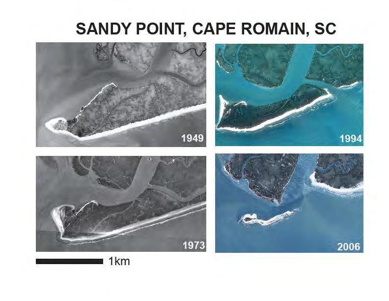
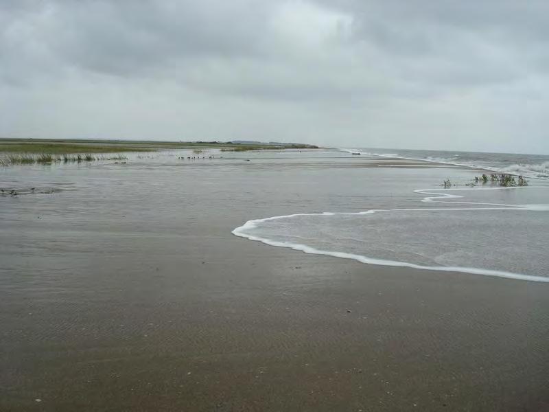
16

17 All That Remains of Sandy Point February, 2009 WRONG! It was gone by Halloween Prediction Gone by Christmas, 2009

18 Impacts on Seabird Nesting Habitat on Sandy Point Least Tern Nesting % Decline % Decline Black Skimmers % Decline

19 Bulls Island Historic Shorelines Compared to today s shoreline: 1852: 2,950 ft 1920: 1,885 ft 1962: 870 ft : 225 ft Average rate of erosion: 20 to 25 ft/yr


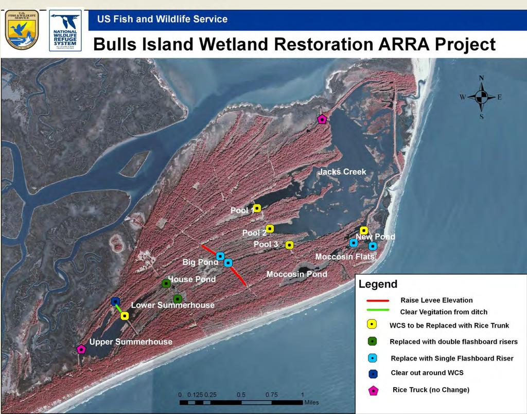
20 Jack s Creek Jacks Creek Levee Position of Levee in 1949 Current Levee constructed 1988 Redirected levee 2006

21 Future Breach How long before the next breach in the Levee? + 5 years

22 Cape Island Historic Shoreline


23 Cape Island 180 feet lost Between 1999 and 2006, approximately 180 linear feet of beach shoreline width was lost to erosion.


24 Erosion on Cape Island High Tide Low Tide Photo by Steve Hillebrand

25 Cape Island Topography


26 Cape Island Highest density nesting beach of Northern Nesting Assemblage in SE U.S. 1 Represented 23% of NNA nesting Nest Protection Project Nest caging Hatcheries Relocated Nest on Cape Island Hatchery on Cape Island Global Distribution of Nesting Assemblages 1 Procyon lotor Looking for nests on Cape Island Cape Island Photo: Steve Johnson

27 Recovery Program Challenges Due to Sea Level Rise Suitable nesting beaches are eroding Islands likely to destabilize, fragment More nests are subject to inundation then mortality Rising global temps may affect gender ratio Increased workload needed to address above - not possible with current staff


28 Climate Adaptation To Relocate or Not To Relocate SLR, Severe erosion, and large tidal amplitudes - limits productivity Concerns raised about relocation Might skew sex ratios Could reduce hatchling size and emergence success possibly selects offspring from individuals that consistently select poor nest sites Unnecessary relocation or poor technique can be a threat Caretta caretta eggs being relocated

29 Washover Nests
30 Temperature determines Sex Ratio Mean Mid Third Temp ( C) % Female Pivotal 28 In-Situ 07 Hatchery 07 Hatchery 07 #1 #2 In-Situ 08 Hatchery 08 #1 Nest Type by Year Hatchery 08 Hatchery 08 #2 #3 n=231 Increase in temperature could skew sex ratios.


31 s Lighthouses Circa 1827, 1858 On National Register of Historic Places Remote island Less that 1 meter above sea level. Significant work needed Complicating Wilderness Area prohibitions Photo by Steve Hillebrand

 to determine where marsh will grow SET Stations in Marsh to determine")
32 What do we do now? Study Rapid Head-ward Erosion of Marsh Creeks and how Santee River sediments play a role in the growth of Marsh. Better elevation data (LIDAR) to determine where marsh will grow SET Stations in Marsh to determine level of subsidence/growth Inventory and Monitor Marsh Birds and Diamondback Terrapins for base line information on species that depend on the marsh. Jacks Creek Cross Dike?


33
34


35 Questions? Sunset Photo by Steve Hillebrand
Wilderness Lost. Cape Romain National Wildlife Refuge. South Carolina Lowcountry Refuge Complex
 Wilderness Lost Cape Romain National Wildlife Refuge South Carolina Lowcountry Refuge Complex Waccamaw NWR 22,859 Acres Santee NWR 12,483 Acres Cape Romain NWR 66,287 Acres Ernest F. Hollings ACE Basin
Project Summary. Predicting waterbird nest distributions on the Yukon-Kuskokwim Delta of Alaska
 Project Summary 1. PROJECT INFORMATION Title Project ID Predicting waterbird nest distributions on the Yukon-Kuskokwim Delta of Alaska WA2012_22 Project Period July 1, 2012 to June 30, 2014 Report submission
Piping Plovers - An Endangered Beach Nesting Bird, and The Threat of Habitat Loss With. Predicted Sea Level Rise in Cape May County.
 Piping Plovers - An Endangered Beach Nesting Bird, and The Threat of Habitat Loss With Thomas Thorsen May 5 th, 2009 Predicted Sea Level Rise in Cape May County. Introduction and Background Piping Plovers
Cat Island Chain Restoration Project Brown County Port & Resource Recovery Department
 Cat Island Chain Restoration Project Brown County Port & Resource Recovery Department February 2, 2015 Fox River and Lower Green Bay Cat Island Chain - 1938 Cat Island Brown County Aerial Photography,
National Fish and Wildlife Foundation Executive Summary for the American Oystercatcher Business Plan
 National Fish and Wildlife Foundation Executive Summary for the American Oystercatcher Business Plan October 26, 2008 AMOY Exec Sum Plan.indd 1 8/11/09 5:24:00 PM Colorado Native Fishes Upper Green River
Geographic Response Plan Map: SC-56. Map Continued on SC-50 XXX. Fripps Inlet. Raptor Nesting Area. Recreational Fishing. Sea Turtles.
 32 22'30"N Map Continued on SC-55 80 30'0"W X ull et SC56-01 Story/Harbor River Junction Story River!h!S(!d Old House Creek 1050 [ 400 1000 SC56-03 Old House Creek «Geographic Response Plan Map: SC-56
Chesapeake Bay adaptation Designing marshes for David Curson, National Audubon Society Erik Meyers, The Conservation Fund
 Chesapeake Bay adaptation Designing marshes for 2100 David Curson, National Audubon Society Erik Meyers, The Conservation Fund Blackwater National Wildlife Refuge Maryland s Everglades Biological Resources:
Maryland Coastal Bays Colonial Waterbird and Islands Report 2018
 Maryland Coastal s Colonial Waterbird and Islands Report 2018 THE REPORT This report provides an assessment of the current state of colonial waterbird breeding in the Coastal s of Maryland behind Ocean
Geographic Response Plan Map: SC-50. Map Continued on SC-42. St Helena Sound. SC50-04 Ashepoo River. Combahee. Bank
 Back -05 e Morgan Village Creek # 32 30'0"N Beaufort County Coosaw R Creeks Map Continued on SC-49 750 900 SC42-03 ICWW - 80 30'0"W Coosaw River iver 1050 1050 Coosaw River Morgan Back Creeks Village Creek
NPS Inventory and Monitoring Program
 NPS Inventory and Monitoring Program Metrics and Protocols Monitoring Tidal Marsh Condition Tidal Marsh Resiliency Coordination Workshop U.S. Fish & Wildlife Service, Hadley, MA Dec 8-9, 2014 Northeast
Species Response to Habitat Restoration and Management in San Francisco Bay
 Species Response to Habitat Restoration and Management in San Francisco Bay Joy Albertson, U.S. Fish and Wildlife Service October 11, 2017 2017 State of the San Francisco Estuary Conference Past (~1850)
A Rising Tide: Conserving Shorebirds and Shorebird Habitat within the Columbia River Estuary
 A Rising Tide: Conserving Shorebirds and Shorebird Habitat within the Columbia River Estuary By Vanessa Loverti USFWS Migratory Birds and Habitat Programs, Portland, Oregon May 28, 2014 Outline of Talk
Wetland Restoration at Blackwater NWR. Dixie Birch November 2, 2006
 Wetland Restoration at Blackwater NWR Dixie Birch November 2, 2006 Goal: Restore 20,000 acres In Dorchester County including 11,000 at Blackwater Strategic Partnerships Remaining marsh shown in red Blackwater
[ Gull/Tern Nesting Area
 33 30'0"N 79 15'0"W Geographic Response Plan Map: SC-10 Georgetown County Chapel Creek Tho roughfar e C reek Holly Hill 550 200 SC10-04 (tidal flats) 79 7'30"W Br ook g Sandhole Creek Oaks Island 33 30'0"N
1. Qualitative Assessment... II-101
 Table of Contents I. Introduction... I-1 A. Session Law 2009-479 / House Bill 709... I-2 B. Public Consultation... I-3 C. Selection of Study Sites... I-5 D. Limitations of Study... I-8 II. Physical Assessment...
Geographic Response Plan Map: GA-2. Raptor Nesting Area. Recreational Fishing. Sea Turtles. Shorebird Nesting Area. Wading birds Nesting Area
 81 7'30"W Geographic Response Plan Map: GA-2 81 0'0"W 32 15'0"N 32 15'0"N Union Creek «46 Jasper Beaufort «170 Sector Charleston Sava n nah «170 and 2 AH NATIONAL FE REFUGE Middle River GA1-07 Steam Boat
Geographic [x Response Plan Map: GA-12 [r. Map Continued on GA-8 XXX. GA12-01 Green Island Sound. OSSABAW ISLAND WMA Raccoon Key XXX
 Charles Ogeechee River tal Waterway 31 52'30"N Little Ogeechee River Harveys Island 81 7'30"W Charles Rush Charles 950 Ogeechee River Geographic Response Plan Map: GA-12 Map Continued on GA-8 Green Island
Siletz Bay BCS number: 47-29
 Siletz Bay BCS number: 47-29 ***NOTE: We were unable to determine all necessary information for this site description. If you would like to contribute the needed information to this description, please
2/26/ % located in Collier, Lee, Monroe, Dade Ten Thousand Islands region Tampa Bay & Indian River Lagoon Largest mangrove forest in USA
 Mangroves Florida: 190,000 hectares of mangrove 90% located in Collier, Lee, Monroe, Dade Ten Thousand Islands region Tampa Bay & Indian River Lagoon Largest mangrove forest in USA Mangroves: tropical
Charette Vision #1 for 2050
 Charette Vision #1 for 2050 Bird use? mercury? Charette Vision #2 for 2050 Important Uncertainties Mercury Sediment Dynamics/Mudflats Bird Use of Different Habitats, esp. tidal marsh ponds/pannes Non-avian
Expansion Work Has Begun The perimeter dike for Cell 7 is now visible
 Summer/Fall 2017 In This Issue Poplar Island Expansion Wetland Cell 5AB Development Wildlife Update Birding tours on Poplar Island Expansion Work Has Begun The perimeter dike for Cell 7 is now visible
Birding Information for Photographers DPI- SIG 5/9/2013
 Birding Information for Photographers DPI- SIG 5/9/2013 Title: Finding the Birds by Arthur Sissman & Ron Perkins 20 minutes I. Factors to Consider Tides (Charts) Water - Fresh, Salt, Brackish Habitat Time
Impacts of Sea-Level Rise on National Wildlife Refuges
 Impacts of Sea-Level Rise on National Wildlife Refuges Considerations for Land Protection Priorities at Blackwater, Great White Heron, Laguna Atascosa & Lower Rio Grande Valley, Lower Suwannee, Cape Romain,
LOUISIANA NAWCA PROJECTS
 LOUISIANA NAWCA PROJECTS $47,109,174 $123,650,071 64 1,174,349 NAWCA GRANT AMOUNT TOTAL PARTNER CONTRIBUTION NUMBER OF PROJECTS TOTAL ACRES Louisiana currently has 64 NAWCA projects either completed or
Dredging, Beach Nourishment and. Bird Conservation Workshop Atlantic Coast Region
 Dredging, Beach Nourishment and US Army Corps Bird Conservation Workshop Atlantic Coast Region Beach Nourishment and Bird Habitat Restoration in Southern New Jersey Shore Protection and Ecosystem Restoration
Roberts Bank Terminal 2 Project Field Studies Information Sheet
 July 2012 Port Metro Vancouver is continuing field studies in July as part of ongoing environmental and technical work for the proposed Roberts Bank Terminal 2 Project. Roberts Bank Terminal 2 Project
LESSONS FROM HURRICANE FLORENCE: TOOLS TO PROTECT BIRDS AND PEOPLE October 14, 2018
 LESSONS FROM HURRICANE FLORENCE: TOOLS TO PROTECT BIRDS AND PEOPLE October 14, 2018 One month ago, the Coastal Carolinas experienced firsthand the widespread impacts of Hurricane Florence. For birds and
(With Apologies to Bob Dylan) David A. Jay. Department of Civil & Environmental Engineering Portland State University Portland, OR USA
 David A. Jay. Department of Civil & Environmental Engineering Portland State University Portland, OR USA") The Tides they are a Changin (With Apologies to Bob Dylan) David A. Jay Department of Civil & Environmental Engineering Portland State University Portland, OR 97207 USA Thanks to Richard Ray, Rich Pawlowicz,,
The Tides they are a Changin (With Apologies to Bob Dylan) David A. Jay Department of Civil & Environmental Engineering Portland State University Portland, OR 97207 USA Thanks to Richard Ray, Rich Pawlowicz,,
Collaboration and Planning to Implement the South San Diego Bay Restoration and Enhancement Project
 Collaboration and Planning to Implement the South San Diego Bay Restoration and Enhancement Project Carolyn Lieberman Coastal Program Coordinator for Southern California U.S. Fish and Wildlife Service
Special Habitats In Greene County
 Special Habitats In Greene County What does Greene County have in common with these animals.. That need special grassland habitat to survive? Or these That need special wetland habitat to survive? We have
DREDGED MATERIAL SETTLEMENT FROM MARSH CREATION PROJECTS CONDUCTED IN COASTAL LOUISIANA
 DREDGED MATERIAL SETTLEMENT FROM MARSH CREATION PROJECTS CONDUCTED IN COASTAL LOUISIANA Thomas McGinnis CPRA Operations Division Lafayette Regional Office National Conference on Ecosystem Restoration August
Cape May: Fall Migration With Naturalist Journeys & Caligo Ventures
 October 15 22, 2017 866.900.1146 800.426.7781 520.558.1146 naturalistjourneys@gmail.com www.naturalistjourneys.com or find us on Facebook at Naturalist Journeys, LLC Cape May is considered the top birding
Coos Bay BCS number: 47-8
 Coos Bay BCS number: 47-8 ***NOTE: The completion of this site description is still in progress by our Primary Contact (listed below). However, if you would like to contribute additional information to
Dr. Wiley Kitchens. University of Florida USGS Florida Cooperative Fish and Wildlife Research Unit
 Tidal Wetland Studies Part I: Tide Gate Era Dr. Wiley Kitchens University of Florida USGS Florida Cooperative Fish and Wildlife Research Unit PRE TIDE GATE ERA MARSH AREAS SAVANNAH NWR GEORGIA/ TOTAL S.
Dare County DEIS Position Statement
 Dare County DEIS Position Statement SUMMARY The Dare County Board of Commissioners strongly supports open and accessible beaches for the Cape Hatteras National Seashore Recreational Area. We believe in
Northeast Florida Coastal Wetland Restoration Program A Partnership Based Regional Approach for Estuary Habitat Restoration
 Northeast Florida Coastal Wetland Restoration Program A Partnership Based Regional Approach for Estuary Habitat Restoration Paul Haydt Restore America s Estuaries November 15, 2010 St Johns River Water
Piping Plovers in Jamaica Bay
 Piping Plovers in Jamaica Bay Hanem Abouelezz, Biologist Jamaica Bay Unit Gateway National Recreation Area National Park Service Threatened and Endangered Species Our mission is to reduce the risk of
4.18 HAMFORD WATER. LTC site code:
 4.18 HAMFORD WATER LTC site code: BH Centre grid: TM2325 JNCC estuarine review site: 110 Habitat zonation: 367 ha intertidal, 106 ha subtidal, 58 ha nontidal Statutory status: Hamford Water SPA (UK9009131),
1/18/2008. Wetlands Reservoirs of Biodiversity Billy McCord, SCDNR. Estuaries. Freshwater Riverine. Tidal Riverine Fresh & Brackish
 Wetlands Reservoirs of Biodiversity Billy McCord, SCDNR Estuaries Freshwater Riverine Tidal Riverine Fresh & Brackish 1 Freshwater Riverine, Oxbows & Swamp Forest Cypress Tupelo Swamp Forest Bottomland
Monitoring Bird, Fish, and Vegetation Communities at Prime Hook NWR Before, During, and After Tidal Marsh Restoration
 Monitoring Bird, Fish, and Vegetation Communities at Prime Hook NWR Before, During, and After Tidal Marsh Restoration Susan Guiteras Supervisory Wildlife Biologist USFWS Coastal Delaware National Wildlife
Backcountry Management. Anne Morkill Wildlife Refuge Manager U.S. Fish & Wildlife Service
 Backcountry Management Anne Morkill Wildlife Refuge Manager U.S. Fish & Wildlife Service Florida Keys National Marine Sanctuary Advisory Council Duck Key, FL February 21, 2012 Overview of National Wildlife
Matagorda Island Marsh Restoration An Adaptive Management Approach by Coastal Bend Bays & Estuaries Program
 Matagorda Island Marsh Restoration An Adaptive Management Approach by Coastal Bend Bays & Estuaries Program 1957: After Levees 1930: Before Levees Matagorda Island: Site Location Texas Coastal Bend Calhoun
Florida Keys National Wildlife Refuge Complex. Key West NWR Great White Heron NWR National Key Deer NWR Crocodile Lake NWR
 Florida Keys National Wildlife Refuge Complex Key West NWR Great White Heron NWR National Key Deer NWR Crocodile Lake NWR Key West NWR Marquesas Keys and 13 other keys Mission as a preserve and protect
Roberts Bank Terminal 2 Project Field Studies Information Sheet
 January 2013 Port Metro Vancouver is continuing field studies in January as part of ongoing environmental and technical work for the proposed. The is a proposed new multi berth container terminal which
SURVEY OF SEAGRASS BEDS AT PLACEMENT AREA 62, WEST BAY CONTRACT FOR GIWW, TEXAS CAUSEWAY U. S. ARMY CORPS OF ENGINEERS CONTRACT NO.
 SURVEY OF SEAGRASS BEDS AT PLACEMENT AREA 62, WEST BAY CONTRACT FOR GIWW, TEXAS CAUSEWAY U. S. ARMY CORPS OF ENGINEERS CONTRACT NO. W912HY-10-C-0036 Prepared for: RLB CONTRACTING, INC. P.O. Box 1739 Port
THE GULF COAST VULNERABILITY ASSESSMENT:
 THE GULF COAST VULNERABILITY ASSESSMENT: Amanda Watson GCVA Coordinator Mississippi State University Gulf Coast Prairie LCC June 3, 2015 Webinar Why? Changing Conditions Conservation is increasingly challenging
APPENDIX M BIRD NESTING DATA ( )
") APPENDIX M BIRD NESTING DATA (1984-2011) Final Environmental Impact Statement Village of Bald Head Island Shoreline Protection Project Brunswick County, North Carolina Date Species Number of Birds Number
APPENDIX M BIRD NESTING DATA (1984-2011) Final Environmental Impact Statement Village of Bald Head Island Shoreline Protection Project Brunswick County, North Carolina Date Species Number of Birds Number
Species Conclusions Table
 Project Manager: Melissa Nash Project Name: Sandbridge Road/Nimmo VII-A Project Description:City of Virginia Beach safety improvements to Sandbridge Rd from McClanan s Curve to one mile east of intersection
Calidris alpina schinzii Baltic/SW Europe & NW Africa
 Period 2008-2012 European Environment Agency European Topic Centre on Biological Diversity Calidris alpina schinzii Baltic/SW Europe & NW Africa Annex I International action plan Yes No Dunlin, Calidris
Habitat Use by Wildlife in Agricultural and Ranching Areas in the Pantanal and Everglades. Dr. Júlio Cesar de Souza and Dr. Elise V.
 Habitat Use by Wildlife in Agricultural and Ranching Areas in the Pantanal and Everglades Dr. Júlio Cesar de Souza and Dr. Elise V. Pearlstine Pantanal 140,000 km 2 of wetlands with a monomodal flood pulse
CHAPTER. Coastal Birds CONTENTS. Introduction Coastal Birds Action Plan. 108 cbbep.org
 CHAPTER 9 Coastal Birds CONTENTS Introduction Coastal Birds Action Plan 108 cbbep.org Introduction The South Texas coast is one of the most unique areas in North America and is renowned for its exceptional
McNabney Marsh Nesting Bird Surveys
 McNabney Marsh 2014 Nesting Bird Surveys Prepared for: Mt View Sanitary District PO Box 2757 Martinez, CA 94553 Contact: Kelly Davidson 925.228.5635 Prepared by: PO Box 188888 Sacramento, CA 95818 Contact:
Priority Bird Species and Habitats U.S. Gulf Coast
 Priority Bird Species and Habitats U.S. Gulf Coast Important Bird Habitats Along Gulf Coast: Beaches, Barrier Islands & Spoil Islands Emergent Wetlands (Marshes) Intertidal Flats Seagrass Beds Mollusk
Key Findings of the 2017 South Florida Wading Bird Report
 The 2017 wading bird nesting season produced some of the highest nest counts in a decade, with a total of 46,248 nests which represents a moderate improvement from the 10-year annual average of 39,065
The implementation of Ramsar Convention in Lebanon
 The implementation of Ramsar Convention in Lebanon Nabil Assaf Ramsar Focal point Ministry of Environment Regional meeting, LAS Cairo 22-25 June 2009 Date of Ratification: 16 August, 1999 4 Ramsar sites
Waterbird Nesting Ecology and Management in San Francisco Bay
 Waterbird Nesting Ecology and Management in San Francisco Bay Josh Ackerman, Alex Hartman, Mark Herzog, and Sarah Peterson U.S. Geological Survey (October 11, 2017) Outline Wetland Management for Nesting
How will Slapton Ley Evolve in the Next 100 Years?
 How will Slapton Ley Evolve in the Next 100 Years? Summary A concern for the communities around Start Bay is that, much further in the future, evolution of the Slapton Line shingle beach will lead to a
Roberts Bank Terminal 2 Project Field Studies Information Sheet
 May 2013 Port Metro Vancouver is continuing field studies in May as part of ongoing environmental and technical work for the proposed Roberts Bank Terminal 2 Project. Roberts Bank Terminal 2 Project The
Geographic Response Plan Map: EFL-56. Map Continued on Page: GA-37. George Crady Fishing Pier State Park. Amelia Island State Park
 30 37'30"N 81 30'0"W Big Piney Island Nassau River - St. Johns River Marshes k Aquatic Preserve!d!] Crane Island AB A1A ") 108! Geographic Response Plan Map: EFL-56 AB 200 Map Continued on Page: GA-37
Are Horseshoe Crab Eggs a Limiting Resource for Red Knots?
 Are Horseshoe Crab Eggs a Limiting Resource for Red Knots? Sarah Karpanty, Jim Fraser, Jim Berkson Department of Fisheries and Wildlife Science Eric Smith Department of Statistics Shorebirds and Horseshoe
2008 San Francisco Bay Shorebird Census
 2008 San Francisco Bay Shorebird Census San Francisco Bay is a great place for shorebirds! The salt ponds, tidal flats, marshes and seasonal wetlands provide important habitat for over a million resident
The Long Point Causeway: a history and future for reptiles. Scott Gillingwater
 The Long Point Causeway: a history and future for reptiles Scott Gillingwater Environmental Effects Long Point World Biosphere Reserve UNESCO designated the Long Point World Biosphere Reserve in April
A Comparison of American Oystercatcher Reproductive Success on Barrier Beach and River Island Habitats in Coastal North Carolina
 A Comparison of American Oystercatcher Reproductive Success on Barrier Beach and River Island Habitats in Coastal North Carolina CONOR P. MCGOWAN 1 *, THEODORE R. SIMONS 1,4, WALKER GOLDER 2 AND JEFF CORDES
Tahkenitch Creek Estuary BCS number: 47-35
 Tahkenitch Creek Estuary BCS number: 47-35 ***NOTE: We were unable to determine all necessary information for this site description. If you would like to contribute the needed information to this description,
Sauvie Island Wildlife Area BCS number: 47-28
 Sauvie Island Wildlife Area BCS number: 47-28 Site description author(s) Mark Nebeker, Oregon Department of Fish and Wildlife, Sauvie Island Wildlife Area Manager Primary contact for this site Mark Nebeker,
Hurricane impacts on mangrove Diamondback terrapins (Malaclemys( terrapin) ) in the Everglades
 ) in the Everglades") Hurricane impacts on mangrove Diamondback terrapins (Malaclemys( terrapin) ) in the Everglades Kristen M. Hart, Catherine A. Langtimm, Carole C. McIvor USGS Florida Integrated Science Center Malaclemys
Hurricane impacts on mangrove Diamondback terrapins (Malaclemys( terrapin) ) in the Everglades Kristen M. Hart, Catherine A. Langtimm, Carole C. McIvor USGS Florida Integrated Science Center Malaclemys
Geographic [ Response Plan Map: GA-9. Map Continued on GA-5 FORT PULASKI. Shad River XXX. GA9-01 Lazaretto Creek West.
 of ake) rsh Creek s Creek!S(!d Chatham County!h Wilmington River Odingsell River D EFUGE 32 0'0"N Map Continued on GA-8 31 52'30"N 81 0'0"W 450 Odingsell River 350 Wilmington River Romerly Marsh Creek
15 November 1969: Prior to Baptiste Collette channel construction
 DREDGED MATERIAL DISPOSAL HISTORY Baptiste Collette Bayou existed as a small canal in 1868 that extended between the Mississippi River and what was then known as the Bird Island Sound. In 1874, a crevasse
Calidris alpina schinzii Britain & Ireland/SW Europe & NW Africa
 Period 2008-2012 European Environment Agency European Topic Centre on Biological Diversity Calidris alpina schinzii Britain & Ireland/SW Europe & NW Africa Annex I International action plan Yes No Dunlin,
The North American Wetlands Conservation Act: Working for Maine
 The North American Wetlands Conservation Act: Working for Maine The North American Wetlands Conservation Act (NAWCA) is an incentive-based, landowner-friendly program that fosters the development of public-private
Ms. Robyn Thorson Director, Region 1 U.S. Fish and Wildlife Service 911 NE 11 th Avenue Portland, Oregon November Dear Ms.
 Ms. Robyn Thorson Director, Region 1 U.S. Fish and Wildlife Service 911 NE 11 th Avenue Portland, Oregon 97232 16 November 2009 Dear Ms. Thorson, For the last decade, U.S. Shorebird Conservation Plan partners
HURRICANE IRMA. Assessment Report
 HURRICANE IRMA Assessment Report This assessment provides a detailed early look at the impacts of Hurricane Irma to the critical bird and wildlife habitats of the affected areas in Florida. Early recovery
McKay Creek National Wildlife Refuge BCS number: 48-19
 Oregon Coordinated Aquatic Bird Monitoring: Description of Important Aquatic Bird Site McKay Creek National Wildlife Refuge BCS number: 48-19 Site description author(s) Howard Browers, Supervisory Wildlife
TABLE OF CONTENTS. Executive Summary 1 Acknowledgements 3 Introduction 3 Storm Recovery and Beach Project Effectiveness 3
 TABLE OF CONTENTS Executive Summary 1 Acknowledgements 3 Introduction 3 Storm Recovery and Beach Project Effectiveness 3 Monmouth County 4 Figures 1a-1d. Monmouth County Station Locations 5 Site Descriptions
ASSEMBLY JOINT RESOLUTION No. 48 STATE OF NEW JERSEY. 218th LEGISLATURE INTRODUCED JANUARY 29, 2018
 ASSEMBLY JOINT RESOLUTION No. STATE OF NEW JERSEY th LEGISLATURE INTRODUCED JANUARY, 0 Sponsored by: Assemblywoman DIANNE C. GOVE District (Atlantic, Burlington Ocean) Assemblyman BRIAN E. RUMPF District
U.S. Fish and Wildlife Service response to Climate Change. Bob Ford Deputy, SE Science Applications Program U.S. Fish and Wildlife Service
 U.S. Fish and Wildlife Service response to Climate Change Bob Ford Deputy, SE Science Applications Program U.S. Fish and Wildlife Service Sam Hamilton Southeast Regional Director, 1997-2009 U.S. Fish and
BIRD READING ASSIGNMENT
 Ocean Connectors BIRD READING ASSIGNMENT To do before the field trip, in class or at home 1. Students will read Wetland Neighbors. The reading is available on the next page and online at http://oceanconnectors.org/resources.
Black-crowned Night-heron Minnesota Conservation Summary
 Credit Deborah Reynolds Black-crowned Night-heron Minnesota Conservation Summary Audubon Minnesota Spring 2014 The Blueprint for Minnesota Bird Conservation is a project of Audubon Minnesota written by
FRIENDS MATTER. A Successful Clean Up at Miller Island. Friends of the Tampa Bay National Wildlife Refuges, Inc. Fall 2018
 Friends of the Tampa Bay National Wildlife Refuges, Inc. Fall 2018 FRIENDS MATTER Photo by Tom Bell A Successful Clean Up at Miller Island by Patrick Mundus Volunteers from Friends and Florida Audubon
North American Wetlands Conservation Act
 North American Wetlands Conservation Act MAINE Maine currently has 90 NAWCA projects either completed or underway. These projects have conserved a total of 1,031,300 acres of wildlife habitat. NAWCA funding
American Black Duck. Appendix A: Birds. Anas rubripes [B,W] New Hampshire Wildlife Action Plan Appendix A Birds-31
![American Black Duck. Appendix A: Birds. Anas rubripes [B,W] New Hampshire Wildlife Action Plan Appendix A Birds-31](/thumbs/79/80131742.jpg "American Black Duck. Appendix A: Birds. Anas rubripes [B,W] New Hampshire Wildlife Action Plan Appendix A Birds-31") American Black Duck Anas rubripes [B,W] Federal Listing State Listing Global Rank State Rank Regional Status N/A SGCN G5 S4 Very High Photo by Pamela Hunt Justification (Reason for Concern in NH) In the
American Black Duck Anas rubripes [B,W] Federal Listing State Listing Global Rank State Rank Regional Status N/A SGCN G5 S4 Very High Photo by Pamela Hunt Justification (Reason for Concern in NH) In the
NEBA new Good Practice Guide Rob Holland, Technical Lead, OSRL. Copyright Oil Spill Response Limited.
 NEBA new Good Practice Guide Rob Holland, Technical Lead, OSRL Copyright 2015. Oil Spill Response Limited. Overview! Acknowledgments! Background to NEBA! NEBA GPG! NEBA example! Questions NET ENVIRONMENTAL
Richard A. Fischer, Ph.D. U.S. Army Engineer Research and Development Center Environmental Laboratory
 Regional Sediment Management - Beneficial Uses of Dredged Material Along Lake Erie and Tributaries Section 204 of the 1992 Water Resources Development Act Richard A. Fischer, Ph.D. U.S. Army Engineer Research
National Park Service Beach Access Report for July 31, 2008
 National Park Service U.S. Department of the Interior Outer Banks Group: Cape Hatteras National Seashore Fort Raleigh National Historic Site Wright Brothers National Memorial 1401 National Park Road Manteo,
Coastal Wildlife Conservation Initiative
 Coastal Wildlife Conservation Initiative What is the Coastal Wildlife Conservation Initiative? A partnership strategy to address coastal issues that impact wildlife and their habitats USFWS CWCI Vision
Natural Resource Management at South Topsail Beach, NC
 Natural Resource Management at South Topsail Beach, NC by Katherine F. Wright August 2007 Advisor: Dr. Patrick Halpin Masters project submitted in partial fulfillment of the requirements for the Master
PRE-TRIP ITINERARY Little St. Simons Island MAY 6-12, 2018
 Little St. Simons Lodge Cassie Wright PRE-TRIP ITINERARY Little St. Simons Island A SPECIAL NATURE CONSERVANCY DEPARTURE MAY 6-12, 2018 Estimated Price: $2550, per person double occupancy, $3495 per person
Geographic Response Plan Map: SC-42
 w Bowles SC41-07 New Chehaw 750! 80 30'0"W BASIN NERR 32 37'30"N Map Contined on SC-41 32 30'0"N Beafort Conty Coosaw R Ashepoo 80 30'0"W iver Legend Beet Coosaw [!d Crooked SC42-03 ICWW - Coosaw 650 Rock
Soft Engineering Case Study: Wallasea Island
 Soft Engineering Case Study: Wallasea Island Situation By the British Geographer Wallasea Island is on the south side of the Crouch Estuary in Essex and also linked to the Roach Estuary. These estuaries
Little St. Simons Island PRE-TRIP ITINERARY MAY 12-18, 2019 A SPECIAL NATURE CONSERVANCY DEPARTURE
 Little St. Simons Lodge Cassie Wright PRE-TRIP ITINERARY Little St. Simons Island A SPECIAL NATURE CONSERVANCY DEPARTURE MAY 12-18, 2019 Estimated Price: $2,700, per person double occupancy, $4,145 per
Regional Overview of Current Terrapin Collaboration
 Regional Overview of Current Terrapin Collaboration TOM MOHRMAN The Nature Conservancy in Mississippi Gulf Coast Regional Co-Chair, Diamondback Terrapin Working Group Photo credits: (top) Daniel & Robbie
National Audubon Society. Coastal Bird Conservation Program
 National Audubon Society Coastal Bird Conservation Program Coastal Bird Conservation Program This presentation contains original photos and data. For any use of this information, data, maps, or photographs
Lisa B. Beever Greater Everglades Ecosystem Restoration Conference July 15, 2010
 Lisa B. Beever Greater Everglades Ecosystem Restoration Conference July 15, 2010 Climate Ready Estuaries Partnership with 15 NEPs and EPA Barnegat Bay NEP www.epa.gov/cre Comprehensive Conservation and
Bandon Marsh National Wildlife Refuge BCS number: 47-3
 Bandon Marsh National Wildlife Refuge BCS number: 47-3 Site description author(s) William Bridgeland, Wildlife Biologist Primary contact for this site William Bridgeland, Wildlife Biologist, U.S. Fish
You may use the information and images contained in this document for non-commercial, personal, or educational purposes only, provided that you (1)
") You may use the information and images contained in this document for non-commercial, personal, or educational purposes only, provided that you (1) do not modify such information and (2) include proper
You may use the information and images contained in this document for non-commercial, personal, or educational purposes only, provided that you (1) do not modify such information and (2) include proper
3.10 Chesapeake Bay: Local Area Coastal Habitat and Environmental Implications of Sea Level Rise: Anticipated Effects by Multicounty Region
 3.10 Chesapeake Bay: Local Area Coastal Habitat and Environmental Implications of Sea Level Rise: Anticipated Effects by Multicounty Region Author: Ann Shellenbarger Jones, Industrial Economics Inc. The
Ramsar Convention. LI To know and understand the purpose of the Ramsar Convention
 Ramsar Convention LI To know and understand the purpose of the Ramsar Convention Warm Up Change the following statements so they are appropriate for a report: 1 2 3 4 5 We conducted a beach survey last
Conserving the mangrove forests.
 Conserving the mangrove forests. The mangrove forests of Pretty Pool Creek and Four Mile Creek not only lend a unique beauty to the area, they also serve an important role in the environment s ecosystem.
Golf Course Water and Energy Conservation
 Golf Course Water and Energy Conservation The Landings Club Skidaway Island, GA Chris Steigelman The Landings Club on Skidaway Island Director of Golf Course Maintenance 912-695-7243 ChrisS@Landingsclub.com
Ensuring habitat considerations in beach and shoreline management along Delaware Bay a bay wide perspective.
 Ensuring habitat considerations in beach and shoreline management along Delaware Bay a bay wide perspective. Kimberly B. Cole, David B. Carter, Tricia K. Arndt Delaware Coastal Programs Delaware Bay Coastal