Lake Worth Lagoon Initiative Habitat Working Group April 5, :00am 12:00pm
|
|
|
- Joanna Joseph
- 5 years ago
- Views:
Transcription
 233-2400 I.")


1 Lake Worth Lagoon Initiative Habitat Working Group April 5, :00am 12:00pm Palm Beach County Environmental Resources Management 2300 North Jog Road 1 st Floor Vista Center 1E-60 West Palm Beach, FL (561) I. Introductions AGENDA II. Business A. LWL Benthic Analysis at Fixed Transect Locations Cheryl Miller, Coastal Eco-Group B. LWL Fisheries Monitoring Richard Paperno, Ph.D., FWC-FWRI C. LWL Fishing Challenge - PBC D. LWL Habitat Projects PBC E. Legislative Funding Request Mayra Ashton, PBC F. Florida s Wildlife Legacy Initiative Dan O Malley, FWC G. Manatee Season Amber Howell, FWC H. Announcements, Comments I. Future Topic Suggestions III. Next Meeting A. LWLI Steering Committee SFWMD April 18, 2018 B. NEXT LWLI Habitat Working Group September 2018 This group was created as an informal forum for the exchange of information about the Lake Worth Lagoon. We hope to increase our collective awareness of enhancement and monitoring efforts and discuss opportunities and methodologies to restore and protect Lagoon resources. Everyone with an interest in the Lagoon is encouraged to attend and participate. Though we do not vote on any issues, nor make recommendations as a group to any decision-making body, we do expect that ideas generated by these discussions will result in collaborative efforts that enhance the Lagoon and raise public awareness of its valuable resources.


2 Lake Worth Lagoon Benthic Community Study (Coastal Eco-Group)
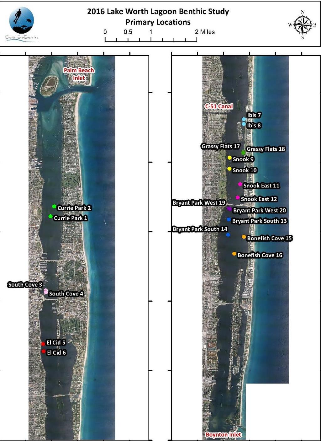

3
4 Benthic Community Diversity Comparisons Sites Transects Richness S-W Diversity SG Transects Impacted Sites Supplemental Impacted Bonefish Cove Bryant Park South Currie Park El Cid Snook East Phil Foster Peanut Island Providencia Monceaux Summa
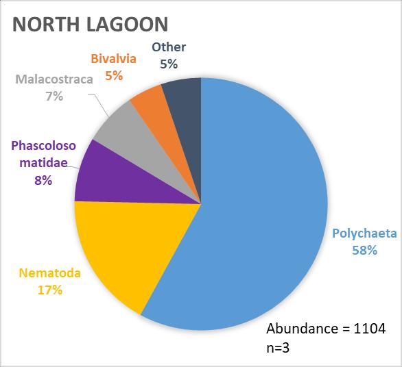
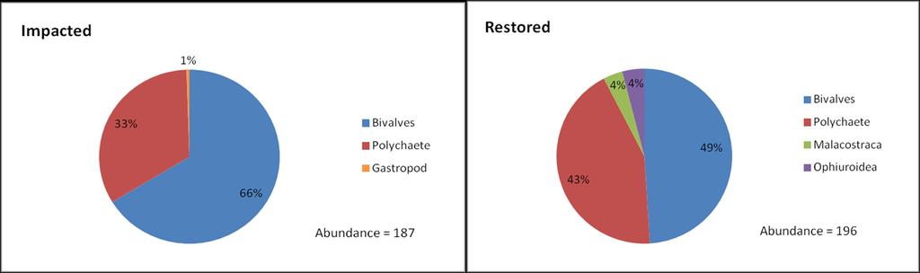
5 Community Composition
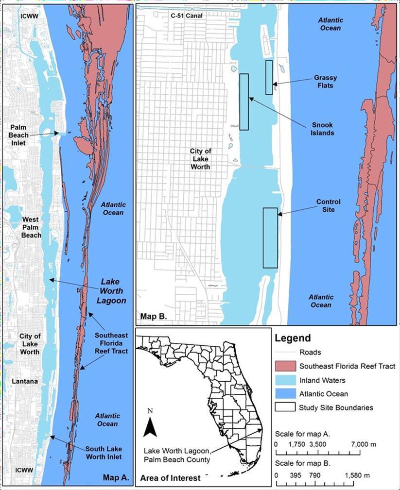
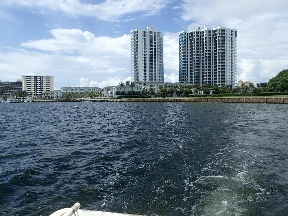
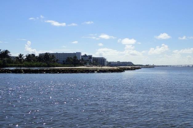
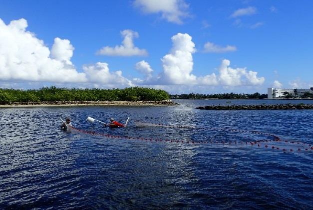
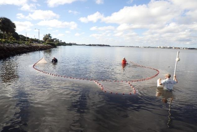
6 Fisheries Monitoring (FWC-FWRI) Munyon Island


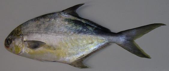

7 Northern Lake Worth Lagoon Increased recreational and offshore/reef-associated species Jacks Snappers Negaprion brevirostris Lemon Shark Albula vulpes, Bonefish Mackerel


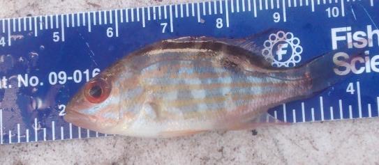
8 Central Lake Worth Lagoon Increased filter feeders and detritivors Anchovies Menhadens/Shads Harengula jaguana (Scaled Sardine)


9 Several species are found in similar abundance throughout Lake Worth Lagoon Shrimp Flatfish Centropomus undecimalis, Common Snook Mojarras Leiostomus xanthurus, Spot


10 Bryant Park Living Shoreline Project Before

11 Volunteers planting Spartina alterniflora and Red Mangroves in the living shoreline planters at Bryant Park

12 Current site conditions

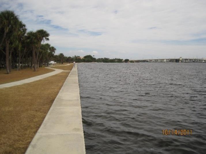
13 Lyman Kayak Park
14 Tarpon Cove Chain of intertidal islands ½ mile in length 250 Capping muck sediments to create 46 acres of habitat ~440 Offshore / ~250 from ICW Kayak Blueway Trail ~400,000 cy of material ~16,000 tons of rock 35 acres sav 2.7 acres intertidal 2.1 acres reef / breakwater

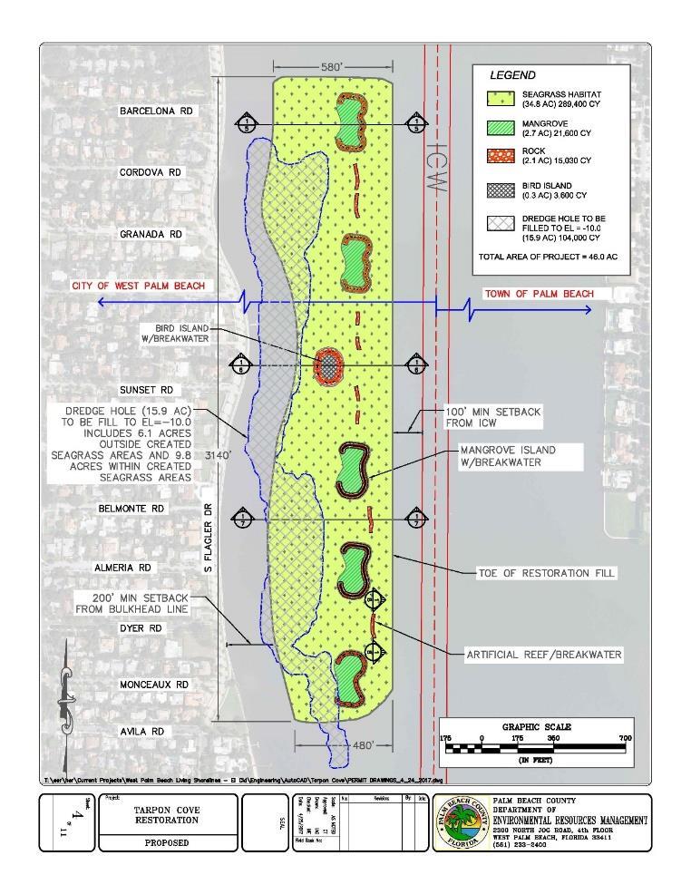
15 Tarpon Cove
 planters.")


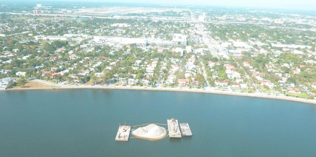
16 Monceaux Park A series of three (3) planters. Construction of limestone planters to create 0.2 acres of intertidal habitat. Installation of limestone riprap to provide oyster habitat and wave attenuation.
")


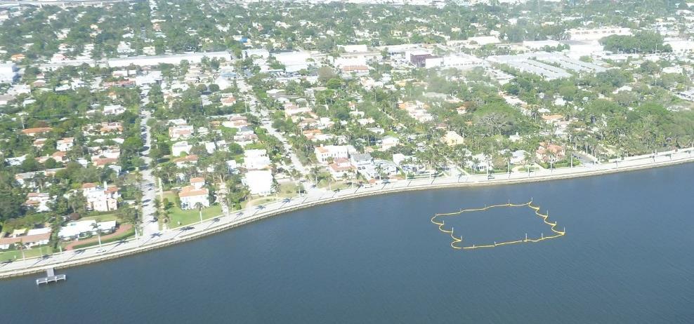
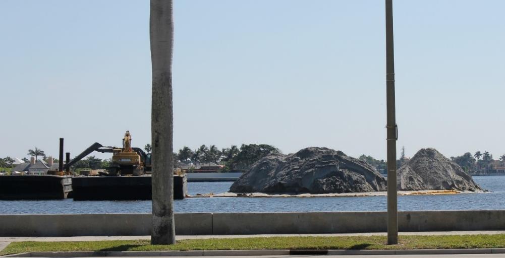
17 Providencia Park A series of three (3) planters and two (2) islands. ~60,000 cy of sand Capping muck sediments to create 6 acres of habitat. ~350 Offshore / ~200 from ICW Kayak Blueway Trail


18 Enhancements to Bird Islands Grassy Flats Bird Nesting Area Snook Islands II Bird Nesting Area Bryant Park Bird Nesting Area

19 Enhancements to Bryant Park Snook Islands II Bird Nesting Berm With Shell Layer Grassy Flats Bird Nesting Berm With Shell Layer

20 Enhancement to Grassy Flats

21 Grassy Flats

22 Grassy Flats

23 Grassy Flats

24 Bryant Park
Lake Worth Lagoon Initiative Habitat Working Group
 Lake Worth Lagoon Initiative Habitat Working Group April 5, 2018 10:00am 12:00pm AGENDA I. Introductions II. Business A. LWL Benthic Analysis at Fixed Transect Locations Cheryl Miller, Coastal Eco-Group
Lake Worth Lagoon Initiative Habitat Working Group September 11, :00pm 4:00pm
 Lake Worth Lagoon Initiative Habitat Working Group September 11, 2018 2:00pm 4:00pm Palm Beach County Environmental Resources Management 2300 North Jog Road 1 st Floor Vista Center 1E-60 West Palm Beach,
Palm Beach County. Estuarine Habitat Mapping
 Palm Beach County Estuarine Habitat Mapping Coastal Habitat Integrated Mapping and Monitoring Program (CHIMMP) April 29, 2014 Eric Anderson, Environmental Analyst Palm Beach County Department of Environmental
Tampa Bay: Planning for large(r)- scale oyster monitoring
- scale oyster monitoring") Tampa Bay: Planning for large(r)- scale oyster monitoring Gary Raulerson, Ecologist Tampa Bay Estuary Program May 23, 2018 OIMMP Workshop GTM Research Reserve Ponte Vedra Beach, FL Photo Credit: C. McIvor,
Tampa Bay: Planning for large(r)- scale oyster monitoring Gary Raulerson, Ecologist Tampa Bay Estuary Program May 23, 2018 OIMMP Workshop GTM Research Reserve Ponte Vedra Beach, FL Photo Credit: C. McIvor,
Geographic Response Plan Map: SC-56. Map Continued on SC-50 XXX. Fripps Inlet. Raptor Nesting Area. Recreational Fishing. Sea Turtles.
 32 22'30"N Map Continued on SC-55 80 30'0"W X ull et SC56-01 Story/Harbor River Junction Story River!h!S(!d Old House Creek 1050 [ 400 1000 SC56-03 Old House Creek «Geographic Response Plan Map: SC-56
Cat Island Chain Restoration Project Brown County Port & Resource Recovery Department
 Cat Island Chain Restoration Project Brown County Port & Resource Recovery Department February 2, 2015 Fox River and Lower Green Bay Cat Island Chain - 1938 Cat Island Brown County Aerial Photography,
Oil Spill Funds and the Opportunities they Present for Galveston Bay
 Oil Spill Funds and the Opportunities they Present for Galveston Bay A presentation to Texas Environmental Grantmakers Group By Bob Stokes, President, Galveston Bay Foundation Friday, October 31, 2014
Welcome to: Mangroves A to Z. Special thanks:
 Welcome to: Mangroves A to Z Special thanks: Our Presenters: Wayne Blythe, SFWMD Heather Carman, SFWMD Richard Cervi, Cervi Associates Katy Collins, FDEP Kate Davis, Davis Environmental Solutions Brandon
Ray Allen Executive Director (361)
") Ray Allen Executive Director (361)885-6204 rallen@cbbep.org www.cbbep.org CBBEP History 1987 U.S. Congress established the National Estuary Program (NEP) to promote longterm planning and management of
Ray Allen Executive Director (361)885-6204 rallen@cbbep.org www.cbbep.org CBBEP History 1987 U.S. Congress established the National Estuary Program (NEP) to promote longterm planning and management of
Geographic Response Plan Map: SFL-31. Bradley. Map continued Key on: SFL-34. Key. Murray Key XXX SFL Clive Key XXX. SFL31-06 Clive Key
 ! 1550 1450 81 0'0"W # [\ m [] Geographic Response Plan Map: SFL-31 Bradley Map continued on: SFL-34 Jow Kemp Florida Bay 80 52'30"W 25 7'30"N 1550 1350 SFL31-01 Conchie Channel SFL31-02 Oyster Oyster
1. Qualitative Assessment... II-101
 Table of Contents I. Introduction... I-1 A. Session Law 2009-479 / House Bill 709... I-2 B. Public Consultation... I-3 C. Selection of Study Sites... I-5 D. Limitations of Study... I-8 II. Physical Assessment...
John s Island Lake Worth Lagoon Standards (NGSSS) Nancy Kinard K-12 STEM Manager Tom Salinsky K-5 Science Program Planner
 Nancy Kinard K-12 STEM Manager Tom Salinsky K-5 Science Program Planner") WWW.LWLI.ORG John s Island Dear Teachers, The Department of Secondary Education is pleased to make Lake Worth Lagoon Discover a Local Treasure available to all 5th and 8th grade students in the School
WWW.LWLI.ORG John s Island Dear Teachers, The Department of Secondary Education is pleased to make Lake Worth Lagoon Discover a Local Treasure available to all 5th and 8th grade students in the School
Matagorda Bay Nature Park
 Matagorda Bay Nature Park N a t u r a l S c i e n c e E d u c a t i o n P r o g r a m s This is such a wonderful facility and the location lends itself to teaching about the coastal environment. This is
Northeast Florida Coastal Wetland Restoration Program A Partnership Based Regional Approach for Estuary Habitat Restoration
 Northeast Florida Coastal Wetland Restoration Program A Partnership Based Regional Approach for Estuary Habitat Restoration Paul Haydt Restore America s Estuaries November 15, 2010 St Johns River Water
Flagler Park Living Shoreline Monitoring Vincent Encomio, Pam Hopkins, Katie Tiling, Josh Mills 9/23/2016
 FLORIDA OCEANOGRAPHIC SOCIETY Flagler Park Living Shoreline Monitoring 2015-2016 Vincent Encomio, Pam Hopkins, Katie Tiling, Josh Mills 9/23/2016 Flagler Living Shoreline Monitoring Summary Constructed
[ Gull/Tern Nesting Area
 33 30'0"N 79 15'0"W Geographic Response Plan Map: SC-10 Georgetown County Chapel Creek Tho roughfar e C reek Holly Hill 550 200 SC10-04 (tidal flats) 79 7'30"W Br ook g Sandhole Creek Oaks Island 33 30'0"N
Site Description: Gull Rock is located approximately 0.4 miles offshore and about six miles north of Yaquina Head in Lincoln County, Oregon.
 Devil s Punchbowl intertidal area Gull Rock (offshore) 12. Gull Rock Site Description: Gull Rock is located approximately 0.4 miles offshore and about six miles north of Yaquina Head in Lincoln County,
The Nature, Value, Conservation Status and Options for the Protection and Restoration of the Biodiversity of Kiritimati Atoll, Republic of Kiribati
 The Nature, Value, Conservation Status and Options for the Protection and Restoration of the Biodiversity of Kiritimati Atoll, Republic of Kiribati Ane Ioran and R. R. Thaman The University of the South
2/26/ % located in Collier, Lee, Monroe, Dade Ten Thousand Islands region Tampa Bay & Indian River Lagoon Largest mangrove forest in USA
 Mangroves Florida: 190,000 hectares of mangrove 90% located in Collier, Lee, Monroe, Dade Ten Thousand Islands region Tampa Bay & Indian River Lagoon Largest mangrove forest in USA Mangroves: tropical
Magic in the Mangroves: A Profile of Mangrove Communities
 Magic in the Mangroves: A Profile of Mangrove Communities What is a Mangrove? A mangrove is a tree that is found in tropical and sub-tropical areas, usually in estuarine waters. The mangrove is a halophyte,,
Backcountry Management. Anne Morkill Wildlife Refuge Manager U.S. Fish & Wildlife Service
 Backcountry Management Anne Morkill Wildlife Refuge Manager U.S. Fish & Wildlife Service Florida Keys National Marine Sanctuary Advisory Council Duck Key, FL February 21, 2012 Overview of National Wildlife
Regional Overview of Current Terrapin Collaboration
 Regional Overview of Current Terrapin Collaboration TOM MOHRMAN The Nature Conservancy in Mississippi Gulf Coast Regional Co-Chair, Diamondback Terrapin Working Group Photo credits: (top) Daniel & Robbie
Geographic Response Plan Map: EFL-56. Map Continued on Page: GA-37. George Crady Fishing Pier State Park. Amelia Island State Park
 30 37'30"N 81 30'0"W Big Piney Island Nassau River - St. Johns River Marshes k Aquatic Preserve!d!] Crane Island AB A1A ") 108! Geographic Response Plan Map: EFL-56 AB 200 Map Continued on Page: GA-37
Geographic Response Plan Map: SC-50. Map Continued on SC-42. St Helena Sound. SC50-04 Ashepoo River. Combahee. Bank
 Back -05 e Morgan Village Creek # 32 30'0"N Beaufort County Coosaw R Creeks Map Continued on SC-49 750 900 SC42-03 ICWW - 80 30'0"W Coosaw River iver 1050 1050 Coosaw River Morgan Back Creeks Village Creek
A Rising Tide: Conserving Shorebirds and Shorebird Habitat within the Columbia River Estuary
 A Rising Tide: Conserving Shorebirds and Shorebird Habitat within the Columbia River Estuary By Vanessa Loverti USFWS Migratory Birds and Habitat Programs, Portland, Oregon May 28, 2014 Outline of Talk
M/C ALYA CENTRAL AND EASTERN ISLANDS 8 DAY / 7 NIGHT CRUISE MONDAY - MONDAY
 M/C ALYA CENTRAL AND EASTERN ISLANDS 8 DAY / 7 NIGHT CRUISE MONDAY - MONDAY DAY BY DAY ISLANDS - San Cristobal - Española - Santa Cruz - North Seymour - Genovesa - Santiago - Bartholome DAY 1 SAN CRISTOBAL
Lisa B. Beever Greater Everglades Ecosystem Restoration Conference July 15, 2010
 Lisa B. Beever Greater Everglades Ecosystem Restoration Conference July 15, 2010 Climate Ready Estuaries Partnership with 15 NEPs and EPA Barnegat Bay NEP www.epa.gov/cre Comprehensive Conservation and
Current Water Quality Conditions and Initial Documentation of Hydrilla (Hydrilla verticillata) in Harveys Lake, Luzerne County, PA
 in Harveys Lake, Luzerne County, PA") Current Water Quality Conditions and Initial Documentation of Hydrilla (Hydrilla verticillata) in Harveys Lake, Luzerne County, PA New York State Federation of Lake Associations 4 th 5 th May 2018 Fred
Current Water Quality Conditions and Initial Documentation of Hydrilla (Hydrilla verticillata) in Harveys Lake, Luzerne County, PA New York State Federation of Lake Associations 4 th 5 th May 2018 Fred
Collaboration and Planning to Implement the South San Diego Bay Restoration and Enhancement Project
 Collaboration and Planning to Implement the South San Diego Bay Restoration and Enhancement Project Carolyn Lieberman Coastal Program Coordinator for Southern California U.S. Fish and Wildlife Service
RESTORE Act Bucket 2 Planning Public Meeting
 RESTORE Act Bucket 2 Planning Public Meeting James C. Gibeaut, Ph.D. Coastal and Marine Geospatial Sciences Harte Research Institute for Gulf of Mexico Studies Texas A&M University Corpus Christi Public
Santa Clara Valley Habitat Plan
 Santa Clara Valley Habitat Plan Joint Governing & Implementation Board Meeting Burrowing Owl Survey Summary and Fee Map January 15, 2015 29 1 Agenda Brief Overview of the Key Aspects of the Burrowing Owl
Acknowledgments. Special thanks to Devin Givens, Inverness Yacht Club members, and Ryan Bartling, California Department of Fish and Wildlife
 Acknowledgments Dr. Ron Coleman, Dr. Ben Becker, and Dr. Sarah Allen Sacramento Landing Marine Research Station Interns and Researchers CSU COAST Grant, Professional Engineers in California Government
Fisheries-Independent Monitoring in the Estero Bay Estuary
 Fisheries-Independent Monitoring in the Estero Bay Estuary project funded by the South Florida Water Management District Philip Stevens, Bob McMichael, Marin Greenwood, and Tim MacDonald Florida Fish and
Environmental Protection
 Myakka Wild and Scenic River Program 2017 Annual Report 1 A. Permitting & Regulatory issues 1. Construction continues at the bridge replacement at C.R. 780. MRP030314 was issued to Sarasota County on March
AGENCY: National Marine Fisheries Service (NMFS), National Oceanic and Atmospheric
, National Oceanic and Atmospheric") This document is scheduled to be published in the Federal Register on 12/30/2014 and available online at http://federalregister.gov/a/2014-30398, and on FDsys.gov Billing Code: 3510-22-P DEPARTMENT OF
This document is scheduled to be published in the Federal Register on 12/30/2014 and available online at http://federalregister.gov/a/2014-30398, and on FDsys.gov Billing Code: 3510-22-P DEPARTMENT OF
Coastal Wildlife Conservation Initiative
 Coastal Wildlife Conservation Initiative What is the Coastal Wildlife Conservation Initiative? A partnership strategy to address coastal issues that impact wildlife and their habitats USFWS CWCI Vision
FWC Proposed CWA s in Southwest Florida Could Impact Boa;ng
 FWC Proposed CWA s in Southwest Florida Could Impact Boa;ng CWAs (Cri)cal Wildlife Area s) are established by FWC to protect important concentra)ons of wildlife and manage human ac)vi)es to minimize and
Report to Species at Risk Conservation Fund. Nova Scotia Nature Trust project - Hemeons Head Conservation Lands
 Report to Species at Risk Conservation Fund Nova Scotia Nature Trust project - Hemeons Head Conservation Lands Photo credit: Alix d Entremont Final Report November 26, 2014 1 Project Goal and Objectives
INDIANA DUNES VISITOR CENTER
 SELF-GUIDED BIRDING INDIANA DUNES VISITOR CENTER 1215 N. State Road 49 The Indiana Dunes is a birder s paradise. Throughout the year, over 370 species of birds are found in the beaches, wetlands, prairies,
State of New Jersey Chris Christie, Governor. Dept. of Environmental Protection Bob Martin, Commissioner
 Cape May Beach 2016/2017 Renourishment Cape May Inlet to Lower Township & Lower Cape May Meadows Cape May Point Cape May County, New Jersey New Jersey Department of Environmental Protection Engineering
TAMU-CC Hike & Bike Trail Revitalization Sub-Committee. TAMU-CC Environmental Advisory Council FY 2009
 TAMU-CC Hike & Bike Trail Revitalization Sub-Committee TAMU-CC Environmental Advisory Council FY 2009 Site Description http://lighthouse.tamucc.edu/chr/wardisland Ward Island bordered by Corpus Christi
Beaver Island Archipelago: Invasive Species Control Final Report Submitted by:
 Beaver Island Archipelago: Invasive Species Control Final Report Submitted by: 4371 N Long Lake Rd Traverse City, MI 49684 wildlife@wildlifewetlands.com (231) 943-0762 Project Plan and Schedule 2014 Treatment
Piping Plovers in Jamaica Bay
 Piping Plovers in Jamaica Bay Hanem Abouelezz, Biologist Jamaica Bay Unit Gateway National Recreation Area National Park Service Threatened and Endangered Species Our mission is to reduce the risk of
BIRD READING ASSIGNMENT
 Ocean Connectors BIRD READING ASSIGNMENT To do before the field trip, in class or at home 1. Students will read Wetland Neighbors. The reading is available on the next page and online at http://oceanconnectors.org/resources.
Bird Species of Special Concern
 Bird Species of Special Concern Florida Keys NWR Complex Kate G. Watts, Lead Wildlife Biologist Bird Species of Special Concern White-crowned Pigeon Reddish Egret Magnificent Frigatebird Great White Heron
Making Informed Decisions
 Making Informed Decisions Scientific research is an essential first step to solve environmental problems. However, many other factors must also be considered. How will the proposed solution affect people
Stay Out Zones and Boom Priorities for Shorebirds in Franklin County
 Stay Out Zones and Boom Priorities for Shorebirds in Franklin County C All the Coastal Beaches that are Publically Owned (State and Federal) have use by nesting birds. These areas are posted. BMPs for
Ramsar Convention. LI To know and understand the purpose of the Ramsar Convention
 Ramsar Convention LI To know and understand the purpose of the Ramsar Convention Warm Up Change the following statements so they are appropriate for a report: 1 2 3 4 5 We conducted a beach survey last
RESTORE ACT Direct Component. Multiyear Implementation Plan Narrative. Plaquemines Parish
 Direct Component Multiyear Implementation Plan Narrative Plaquemines Parish Date: February 24 th, 2015 Eligible Applicant: Point of Contact Name: Point of Contact Title: Plaquemines Parish, Louisiana Amos
2017 Annual Volunteer Report
 2017 Annual Volunteer Report Volunteer Statistics Summary 23,164 DNR 280,419 Hours Donated 135 FTE s (Full Time Equivalents based on a 40-hour work week or 2,080 hours/year.) Volunteer hours are equivalent
DREDGED MATERIAL SETTLEMENT FROM MARSH CREATION PROJECTS CONDUCTED IN COASTAL LOUISIANA
 DREDGED MATERIAL SETTLEMENT FROM MARSH CREATION PROJECTS CONDUCTED IN COASTAL LOUISIANA Thomas McGinnis CPRA Operations Division Lafayette Regional Office National Conference on Ecosystem Restoration August
Expansion Work Has Begun The perimeter dike for Cell 7 is now visible
 Summer/Fall 2017 In This Issue Poplar Island Expansion Wetland Cell 5AB Development Wildlife Update Birding tours on Poplar Island Expansion Work Has Begun The perimeter dike for Cell 7 is now visible
NAPA MARSHES RESTORATION Coastal Ecosystem Restoration Through Collaborative Partnerships
 NAPA MARSHES RESTORATION Coastal Ecosystem Restoration Through Collaborative Partnerships National Conference on Ecosystem Restoration July 29-August 2, 2013 Jeff McCreary Director of Conservation Programs
AERIAL SURVEY OF BIRDS AT MONO LAKE ON AUGUST 24, 1973
 AERIAL SURVEY OF BIRDS AT MONO LAKE ON AUGUST 24, 1973 by Ronald M. Jurek Special Wildlife Investigations Wildlife Management Branch California Department of Fish and Game September 1973 Jurek, R.M. 1973.
Shorebird Roost Rehabilitation at Stockton Sandspit. Project Report 2016
 Shorebird Roost Rehabilitation at Stockton Sandspit Introduction Project Report 2016 Stockton Sandspit is a small but vital component of the Hunter Wetlands National Park and is regarded as one of the
JOB ANNOUNCEMENT. Eastern Oregon Field Coordinator
 JOB ANNOUNCEMENT Job Title: Department: Reports to: Classification: Pay rate: Location: Eastern Oregon Field Coordinator Conservation Department Director of Conservation Non-exempt, Full-time $23/hour
Wendy Webber Regional Director Northeast Regional Office U.S. Fish and Wildlife Service 300 Westgate Center Drive Hadley, MA
 Robert P. LaBelle, Federal Co-lead April 13, 2017 Mid-Atlantic Regional Planning Body BOEM 45600 Woodland Road, Mailstop: VAM-BOEM DIR Sterling, VA 20166 Betsy Nicholson, NE RPB Federal Co-lead NOAA National
The Long Point Causeway: a history and future for reptiles. Scott Gillingwater
 The Long Point Causeway: a history and future for reptiles Scott Gillingwater Environmental Effects Long Point World Biosphere Reserve UNESCO designated the Long Point World Biosphere Reserve in April
United States Department of the Interior
 United States Department of the Interior Mickey T. Sugg Wilmington Regulatory Field Office U. S. Army Corps of Engineers 69 Darlington Ave. Wilmington, North Carolina 28403 FISH AND WILDLIFE SERVICE Raleigh
Alya 8 Day Itinerary A
 Day 1 (Monday) San Cristobal Island Morning flight from Quito or Guayaquil to San Cristobal, Galapagos Islands. You will arrive at San Cristobal Island in the morning. After going through immigration and
Geographic [ Response Plan Map: GA-9. Map Continued on GA-5 FORT PULASKI. Shad River XXX. GA9-01 Lazaretto Creek West.
 of ake) rsh Creek s Creek!S(!d Chatham County!h Wilmington River Odingsell River D EFUGE 32 0'0"N Map Continued on GA-8 31 52'30"N 81 0'0"W 450 Odingsell River 350 Wilmington River Romerly Marsh Creek
WATER BIRDS OF PALM BEACH COUNTY
 WATER BIRDS OF PALM BEACH COUNTY Presented by : The Audubon Society of the Everglades www.auduboneverglades.org Text and Photographs by Larry Hess Types of Water Birds Seen in Palm Beach County Ducks and
Geographic Response Plan Map: SC-42
 w Bowles SC41-07 New Chehaw 750! 80 30'0"W BASIN NERR 32 37'30"N Map Contined on SC-41 32 30'0"N Beafort Conty Coosaw R Ashepoo 80 30'0"W iver Legend Beet Coosaw [!d Crooked SC42-03 ICWW - Coosaw 650 Rock
RESTORE ACT ADVISORY COMMITTEE, PASCO COUNTY, FLORIDA ANNOTATED MINUTES MAY 7, 2015 PREPARED IN THE OFFICE OF PAULA S. O NEIL, CLERK & COMPTROLLER
 RESTORE ACT ADVISORY COMMITTEE, PASCO COUNTY, FLORIDA ANNOTATED MINUTES MAY 7, 2015 PREPARED IN THE OFFICE OF PAULA S. O NEIL, CLERK & COMPTROLLER THE MINUTES WERE PREPARED IN AGENDA ORDER AS PUBLISHED
LAKE RESTORATION & WILDLIFE MANAGEMENT COMMITTEE MEETING MINUTES MARCH 20, 2014
 LAKE RESTORATION & WILDLIFE MANAGEMENT COMMITTEE MEETING MINUTES MARCH 20, 2014 IN ATTENDANCE: Ed Runyon, Chairman (excused) Elizabeth Naskiewicz, Vice Chairman Rich Kleeman Jerry Barron, Env. Commission
Using proxies of anthropogenic disturbance to estimate the distribution of wintering Piping Plovers
 Using proxies of anthropogenic disturbance to estimate the distribution of wintering Piping Plovers Olivia LeDee and Francesca J. Cuthbert Conservation Biology Graduate Program University of Minnesota
2008 San Francisco Bay Shorebird Census
 2008 San Francisco Bay Shorebird Census San Francisco Bay is a great place for shorebirds! The salt ponds, tidal flats, marshes and seasonal wetlands provide important habitat for over a million resident
FRIENDS MATTER. Celebrating Celery Fields. Friends of the Tampa Bay National Wildlife Refuges
 FRIENDS MATTER Celebrating Celery Fields Photo by Dave Howard Did you know that Sarasota County s primary storm-water management area is also a very important bird sanctuary managed by the Florida Audubon
Roberts Bank Terminal 2 Project Field Studies Information Sheet
 January 2013 Port Metro Vancouver is continuing field studies in January as part of ongoing environmental and technical work for the proposed. The is a proposed new multi berth container terminal which
LIFE Nature project Improving the status of the coastal lagoon Tryggelev Nor, Denmark Layman s report
 LIFE Nature project Improving the status of the coastal lagoon Tryggelev Nor, Denmark Layman s report Fyn County, Nature Management & Water Environment Division, in cooperation with the Danish Bird Protection
THE USE OF ACOUSTIC TRANSECTS TO DOCUMENT CHANGES IN BAT DISTRIBUTION AND ABUNDANCE. Eric R. Britzke & Carl Herzog
 THE USE OF ACOUSTIC TRANSECTS TO DOCUMENT CHANGES IN BAT DISTRIBUTION AND ABUNDANCE Eric R. Britzke & Carl Herzog Stressors to Bat Populations White-nose Syndrome Wind energy development Monitoring of
Status of the Coral Reef of Swains Island 1998
 Status of the Coral Reef of Swains Island 1998 Mike Page and Alison Green Department of Marine and Wildlife Resources Government of American Samoa P.O. Box 3730 American Samoa 96799 Swains Island - showing
Rookery Island Clean Ups Remove 8,000 Pounds of Trash and Debris by Kathryn Tunnell
 Stay connected with The Edge: News and Updates from the Coastal Bend Bays & Estuaries Program News and Updates from the Coastal Bend Bays & Estuaries Program Visit Our Website Rookery Island Clean Ups
MULTI-TEMPORAL SATELLITE IMAGES WITH BATHYMETRY CORRECTION FOR MAPPING AND ASSESSING SEAGRASS BED CHANGES IN DONGSHA ATOLL
 MULTI-TEMPORAL SATELLITE IMAGES WITH BATHYMETRY CORRECTION FOR MAPPING AND ASSESSING SEAGRASS BED CHANGES IN DONGSHA ATOLL Chih -Yuan Lin and Hsuan Ren Center for Space and Remote Sensing Research, National
Golden Eagle (Aquila chrysaetos) Management Indicator Species Assessment Ochoco National Forest
 Management Indicator Species Assessment Ochoco National Forest") Golden Eagle (Aquila chrysaetos) Management Indicator Species Assessment Ochoco National Forest I. Introduction The golden eagle was chosen as a terrestrial management indicator species (MIS) on the Ochoco
Golden Eagle (Aquila chrysaetos) Management Indicator Species Assessment Ochoco National Forest I. Introduction The golden eagle was chosen as a terrestrial management indicator species (MIS) on the Ochoco
Local Ed Program GoesYouTube. Staff & Students Producing Course Videos
 A publication of the Apalachicola National Estuarine Research Reserve Spring 2016 Staff & Students Producing Course Videos Local Ed Program GoesYouTube Inside Get Wet & Sandy... 2 Habitat Enhancement...
Spring-Summer Issue 66. The Great Egg Harbor Watershed Association s website has a new look. Check us out.
 Spring-Summer 2015 www.gehwa.org Issue 66 The Great Egg Harbor Watershed Association s website has a new look. Check us out. National Park Foundation 2014 Impact Grant In 2014 the National Park Foundation,
Chesapeake Bay adaptation Designing marshes for David Curson, National Audubon Society Erik Meyers, The Conservation Fund
 Chesapeake Bay adaptation Designing marshes for 2100 David Curson, National Audubon Society Erik Meyers, The Conservation Fund Blackwater National Wildlife Refuge Maryland s Everglades Biological Resources:
Detailed Lighthouse Reef Adventure Itinerary 'Classic Lighthouse Reef 8 Night Adventure'
 [1] Share: var switchto5x = true;stlight.options({"publisher":"dr-61cbf29c-70b8-a347-48ed-c13d26df1b16"}); Detailed Itinerary 'Classic Lighthouse Reef 8 Night Adventure' Beyond the Barrier Reef, past Turneffe
2017 Shell Key Preserve Management Plan Update DRAFT
 2017 Shell Key Preserve Management Plan Update DRAFT Prepared by Pinellas County Parks and Conservation Resources Revised on October 19, 2017 Shell Key Preserve Management Plan Executive Summary State
9:40-10:00: Summary of route surveys conducted by FSA in 2014 in Volusia County
 Volusia Shorebird Partnership Pre-Season Meeting Minutes Monday March 16, 2015, 9:30-12:00 p.m. Beach Safety Headquarters, 3 rd floor conference room 515 S. Atlantic Ave. Daytona Beach, FL Meeting Agenda
Ensuring habitat considerations in beach and shoreline management along Delaware Bay a bay wide perspective.
 Ensuring habitat considerations in beach and shoreline management along Delaware Bay a bay wide perspective. Kimberly B. Cole, David B. Carter, Tricia K. Arndt Delaware Coastal Programs Delaware Bay Coastal
Economic Values Generated by the New Jersey Shore for Climate Change and Coastal Hazards Conference
 Economic Values Generated by the New Jersey Shore for Climate Change and Coastal Hazards Conference Professor Joseph J. Seneca Bloustein School of Planning and Public Policy, Rutgers University 25 May
Public Access and Wildlife: Research that Managers Can Use. Lynne Trulio, SJSU September 28, 2010
 Public Access and Wildlife: Research that Managers Can Use Lynne Trulio, SJSU September 28, 2010 1 Six Project Objectives Ecological Objectives Water and Sediment Quality Infrastructure Public Access Flood
ENDANGERED PLOVERS SINGING PRAISE FOR NEW NATURE TRUST LANDS
 ENDANGERED PLOVERS SINGING PRAISE FOR NEW NATURE TRUST LANDS NEWS RELEASE Embargoed until August 6 th at 10:30 am. Baccaro, N.S. (August 6) The Nova Scotia Nature Trust made yet another exciting leap forward
APPENDIX M BIRD NESTING DATA ( )
") APPENDIX M BIRD NESTING DATA (1984-2011) Final Environmental Impact Statement Village of Bald Head Island Shoreline Protection Project Brunswick County, North Carolina Date Species Number of Birds Number
APPENDIX M BIRD NESTING DATA (1984-2011) Final Environmental Impact Statement Village of Bald Head Island Shoreline Protection Project Brunswick County, North Carolina Date Species Number of Birds Number
T.S Roberts Bird Sanctuary Improvements Project
 T.S Roberts Bird Sanctuary Improvements Project Dr. David Zumeta Ornithology and Forest Habitat Expert Jason Aune Landscape Architect, AFLA Tyler Pederson Project Manager Michael Schroeder Assistant Superintendent
The Marine Managed Areas Inventory of the United States
 The Marine Managed Areas Inventory of the United States The National Marine Protected Areas Center Dan Farrow, MMA Inventory Coordinator Wednesday, June 25, 2003 Overview MMA Inventory Basics Status of
Vava u mangroves surveyed
 this issue Vava u mangroves surveyed Twenty species and counting Native gecko spotted On the ground Tangled Vava u mangroves surveyed With the aim to use GIS as a measure of deriving baseline information
CHAPTER 13: VOLUNTARY CONSERVATION MEASURES
 CHAPTER 13: VOLUNTARY CONSERVATION MEASURES In addition to those formal minimization and mitigation measures identified elsewhere in this HCP, Walton County intends to implement the following voluntary
Division: Habitat and Species Conservation Authors: Claire Sunquist Blunden and Brad Gruver
 Division: Habitat and Species Conservation Authors: Claire Sunquist Blunden and Brad Gruver Report date: December 13, 2018 All photos by FWC unless otherwise acknowledged Presenting 6 new guidelines 1
Tahkenitch Creek Estuary BCS number: 47-35
 Tahkenitch Creek Estuary BCS number: 47-35 ***NOTE: We were unable to determine all necessary information for this site description. If you would like to contribute the needed information to this description,
2016 Breeding Season Guide MARCH 2016
 2016 Breeding Season Guide MARCH 2016 Events & reminders In this issue Events & reminders. 2 FSA news... 3 Pre-season planning checklist Posting nest sites Bird stewarding and outreach Breeding bird surveys
Geographic [x Response Plan Map: GA-12 [r. Map Continued on GA-8 XXX. GA12-01 Green Island Sound. OSSABAW ISLAND WMA Raccoon Key XXX
 Charles Ogeechee River tal Waterway 31 52'30"N Little Ogeechee River Harveys Island 81 7'30"W Charles Rush Charles 950 Ogeechee River Geographic Response Plan Map: GA-12 Map Continued on GA-8 Green Island
Dredging, Beach Nourishment and. Bird Conservation Workshop Atlantic Coast Region
 Dredging, Beach Nourishment and US Army Corps Bird Conservation Workshop Atlantic Coast Region Beach Nourishment and Bird Habitat Restoration in Southern New Jersey Shore Protection and Ecosystem Restoration
Exploring Our Wonderful Wetlands
 Exploring Our Wonderful Wetlands Student Publication Grades 4 7 Dear Wetland Students: Are you ready to explore our wonderful wetlands? We hope so! To help you learn about several types of wetlands in
Canal Current. Environmental News. Native Plant profile
 Canal Current A wave of information for Cape Coral s Canalwatch volunteers Newsletter: 1 st Quarter 2011 Environmental News The BP Oil Spill, 1 year Later The one year anniversary of the BP Deep Water
Marine Corps Support Facility-Blount Island: Integrated Natural Resources Program Successes. E2S2 Conference May 12, 2011
 Marine Corps Support Facility-Blount Island: Integrated Natural Resources Program Successes E2S2 Conference May 12, 2011 Shari Kennedy, MCSF-BI Robert Price, CH2M HILL Location Mission The mission of Marine
DISTRIBUTION AND ABUNDANCE OF SEA DUCKS AND DIVING DUCKS ON LAKE ST. CLAIR AND W. LAKE ERIE
 DISTRIBUTION AND ABUNDANCE OF SEA DUCKS AND DIVING DUCKS ON LAKE ST. CLAIR AND W. LAKE ERIE Dave Luukkonen, Michigan DNR and Michigan State University Importance of Lake St. Clair and western Lake Erie
Wetlands in the Spotlight 10 Easy Steps! Wisconsin s Wetland Gems
 As printed in Wetland News, August 2010, Association of State Wetland Managers, Inc. Wetlands in the Spotlight 10 Easy Steps! Wisconsin s Wetland Gems By Leah Stetson, ASWM The nonprofit Wisconsin Wetlands