DREDGED MATERIAL SETTLEMENT FROM MARSH CREATION PROJECTS CONDUCTED IN COASTAL LOUISIANA
|
|
|
- April Blair
- 5 years ago
- Views:
Transcription

1 DREDGED MATERIAL SETTLEMENT FROM MARSH CREATION PROJECTS CONDUCTED IN COASTAL LOUISIANA Thomas McGinnis CPRA Operations Division Lafayette Regional Office National Conference on Ecosystem Restoration August 28, 2018 committed to our coast committed to our coast

2 From 2017 CPRA Master Plan Symbols are completed or ongoing projects Shading are future projects in Louisiana s Master Plan Attributes Immediate correction of elevation deficiencies Minimizes post construction costs Low liability during and after the project life Deficiencies Does not address the overall problem High planning and construction costs High resources cost


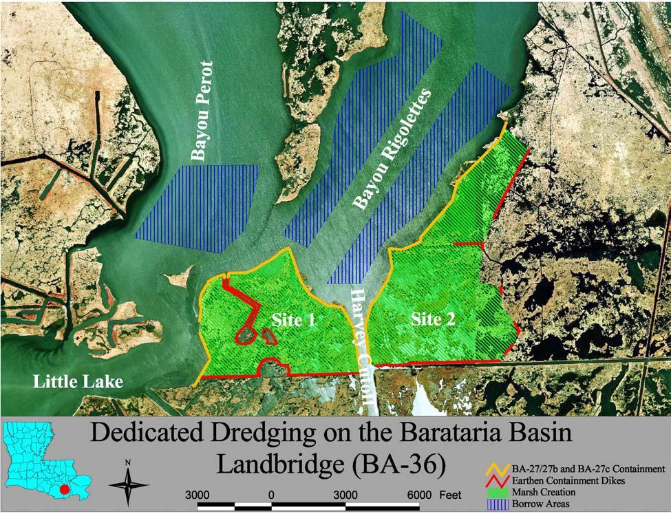
3 Barataria Landbridge B. Perot Current Projects 7 Marsh Creation 4 Shoreline Protection 2 Freshwater Diversions Larger Scale Projects in 2017 Master Plan
4


5 Different Fill Elevations BA-36 Planning - Geotech of borrow and fill areas ~1,174 ac - Target Elevation of ~711 MHW = 0.85 ft ac NAVD88 for most of project life 2.5 Fill Elevation From: LDNR BA-36 Final Design Report - Short-Term: Substrate Compaction - Long- Term: Subsidence (3.7 cm/y)

6 BA-36 Construction CWPPRA: CIAP: State Surplus: Total Cost: $16.2 M 17.5 M 2.4 M $36.1 M Constructed 10/ /2010 Total Acres: 2,789 Dredged Material: ~9 M yd 3 Iterative, Sequential Filling Monitoring: 03/ / OM&M Report by Melissa Hymel
7 BA-36 Results 52% of Volume Remained since Construction ~711 ac ~1,174 ac Based on a series of elevation surveys either conducted in or transformed to Geoid 12A

8 ~711 ac ~1,174 ac HME =

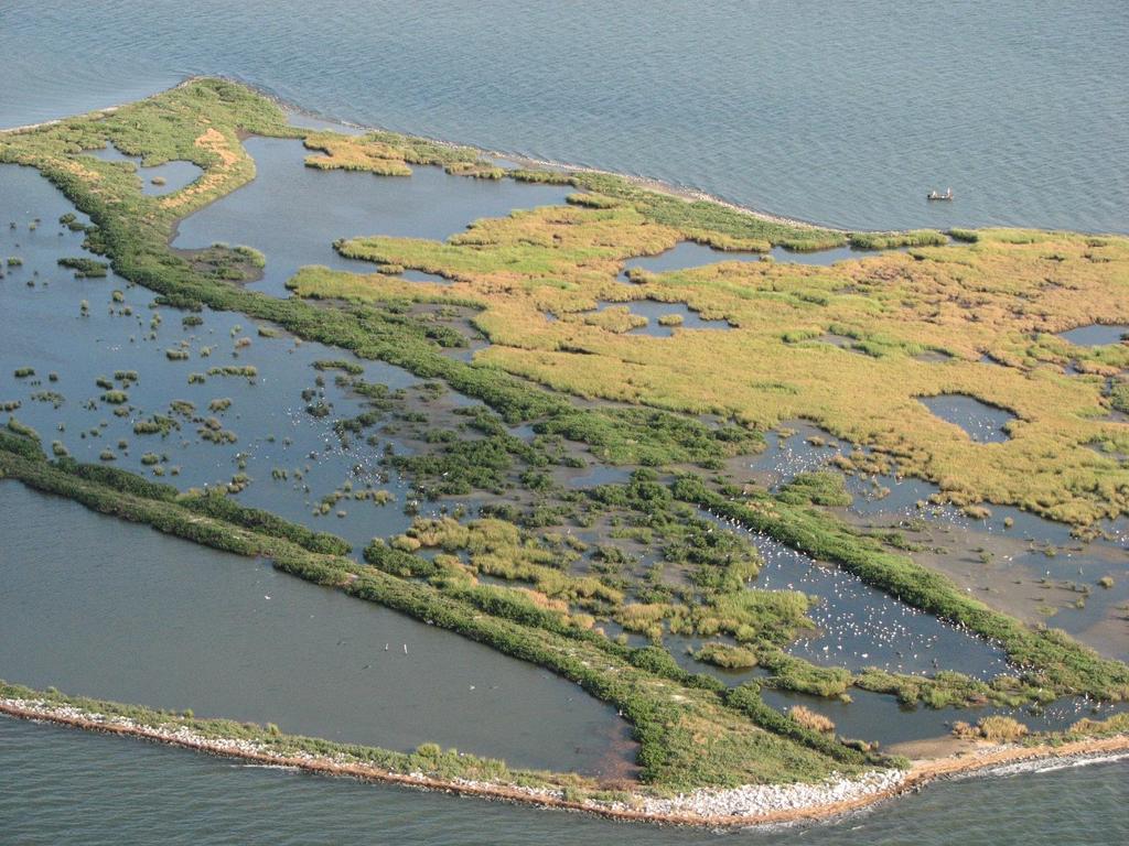
9 BA-37 Little Lake Shoreline Protection / Dedicated Dredging Near Round Lake Southeastern lake rim of the Landbridge Freshwater and Sediment cutoff when Bayou Lafouche was dammed at the Mississippi R Operations, Maintenance, and Monitoring Report by Glen Curole and Ben Hartman

10 BA-37 Little Lake Shoreline Protection / Dedicated Dredging Major Project Components: Shoreline Protection Marsh Creation/Nourishment Program: CWPPRA CRMS6303 Constructed in Sp 2006 and has been monitored for 10 years ~3.6 M yd 3 of material was dredged from the adjacent lake bottom
11 Planned and Actual Sediment Elevation Curves for BA % > Estimated Elevation X m NAVD88, Initial Marsh Elevation Elevation Surveys


12 Land (%) CRMS6303 in BA-37 Land Increased 49% by 6 years after the dredge addition Y Pre Construction Y Post Construction 100 Percent Land over Time Y Post Construction
 projects from Barataria Bay Waterway (BBW) maintenance: - BA-05b State Restoration")
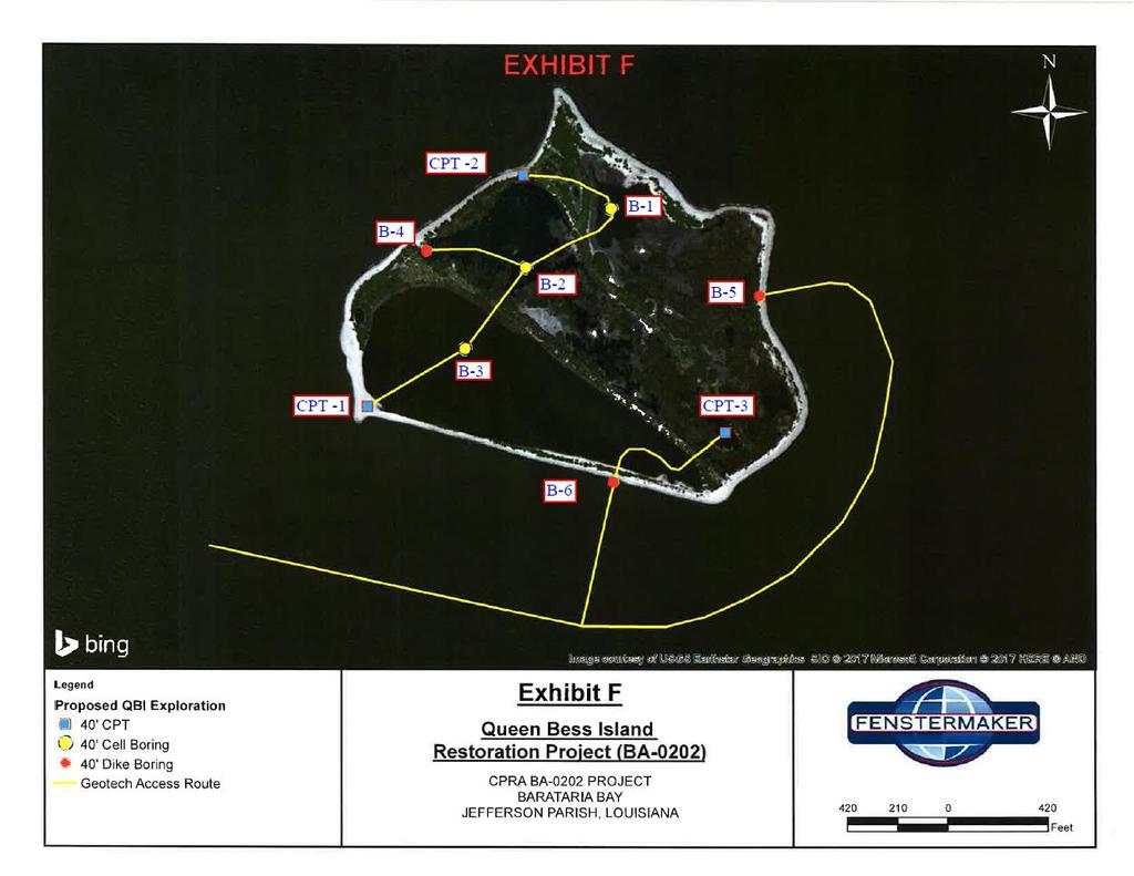
13 Remnant marsh island in Barataria Bay Protected by Grand Isle and Grand Terre Islands. Critical Brown Pelican and other shorebird nursery Early site of Beneficial Use of dredge Material Program (BUMP) projects from Barataria Bay Waterway (BBW) maintenance: - BA-05b State Restoration LDNR-CRD and USACE - BA-19 BBW Wetland Creation 1996 CWPPRA: LDNR-CRD and USACE Planned Habitat Restoration site for Natural Resource Damage Assessment From Deepwater Horizon Oil Spill - BA-0202 Queen Bess Island 2020(?) Queen Bess Island

14 Queen Bess Island (QBI) - Historical Background Decline of Brown Pelicans and the need for restoring habitat The population of 1,000s of brown pelicans reported in 1958 was extinct by 1962, attributed to the use of DDT. Juvenile brown pelicans were reintroduced from Florida in the late 1960s and early 1970s. By 1989, QBI was 1 of only 4 remaining nesting sites in Barataria Bay because of habitat loss. QBI eroded from 45 ac in 1956 to 17 ac in Elevation had reduced such that the island was over washed by small storms. December 1989 Freeze killed all of the black mangroves.
15 BA-05b Queen Bess Island State Restoration Phase 1, 1990 A retainment dike was constructed and dredged material from the Barataria Waterway was pumped inside (75,000 yd 3 ). Nourished existing island to the east. Ridges/Dikes = 3.5 ft NVGD29 Fill Elevation = 2-3 ft NGVD29 Target Elev = ~1 ft NGVD29
16 BA-05b Queen Bess Island State Restoration Phase 2, Wax myrtle and black mangrove were planted along ridges for Brown Pelican nesting. Rip-rap and crushed limestone was placed around the island. Created raised platforms for seabird nesting area. Increased island area from 17 to 32 acres

17 BA-19 Barataria Waterway Wetland Creation 1996 Added rock containment dike to enlarge SW side of island. Dredge material from Barataria Bay Waterway intended to fill project area. Goal: Disposal unit for the COE-BUMP. August 1998 Dredge Material Effluent ~3 inches Shell Dike Elevation = 5.22 ft NGVD29 Fill Elevation = 3.72 ft NGVD29 Target Marsh Elevation = 1.22 ft NGVD29 Marsh Elevation 3 yrs Post = 0.79 ft NGVD29, ft BA-19 dike increased island potential area from 32 to 41 acres; however, the large open water area is ~8 ac.

18 Queen Bess Island and Deepwater Horizon Oil Boom 2010 GoogleEarth P.J. Mann, an employee of Plaquemines Parish, Louisiana, rescues a brown pelican from oil-filled waters on Queen Bess Island, Louisiana, June 5, Oil from the massive BP oil spill in the Gulf of Mexico has fouled the marshlands and injured wildlife. UPI/A.J. Sisco

19 Courtesy: Darin Lee CPRA TRO (Post Isaac, 2012) Courtesy: Darin Lee CPRA TRO (Post Isaac, 2012)
20 BA-0202 QBI Restoration Project National Resources Damage Assessment (NRDA) awarded $20,000,000 - CPRA / LA Dept of Wildlife and Fisheries (LDWF) Goal: Restore suitable shorebird nesting and rearing habitat from < 5 acres to ~36 acres. The designed habitat breakdown: 9.2 acres for Terns & Skimmers 26.8 acres for Brown Pelicans and other colonial nesting water birds. Currently in Planning Stage


21 Cell 1 CMFE: 1.5 ft NAVD88 Target Elev: ft NAVD88 Low Elevation - Fisheries Access Black Mangrove/Salt Marsh Preliminary Plans CH Fenstermaker & Associates Cell 2 CMFE: ft NAVD88 Target Elev: ft NAVD88 Brown Pelican Nesting Area Scrub-Shrub Vegetation Cell 3 CMFE: ft NAVD88 Target Elev: ft NAVD88 Turn and Skimmer Habitat Crushed limestone and shell BA-05b 9 acres BA acres 1989 Island 20 acres
22
23 1.8 ft NAVD ft NAVD ft NAVD ft NAVD88 Cell 1 Dike & Marsh Low Elevation for Nourishment from Cells 1 & ft NAVD88 Cell 1 Salt Marsh Open Water Fill 80% Innundation 1.2 ft NAVD88 Relative Sea-Level Rise Rates (m/y) over 100 yrs ( ) Scenarios 0.01-m = 1 meter of RSLR m = 1.5 meters of RSLR
24 4.1 ft NAVD ft NAVD ft NAVD ft NAVD88 Cell 2 Scrub-Shrub for Brown Pelicans and other colonial nesting birds 10% Exceedance - chance of surface flooding in a given amount of time

25 5.3 ft NAVD ft NAVD ft NAVD ft NAVD88 MLW Cell 3 Dike and Loose Rock Pad for Skimmers and Turns Higher Elevation to Simulate a Beach Ridge Habitat


26 Thanks!!! Any Questions? CONNECT WITH
Cat Island Chain Restoration Project Brown County Port & Resource Recovery Department
 Cat Island Chain Restoration Project Brown County Port & Resource Recovery Department February 2, 2015 Fox River and Lower Green Bay Cat Island Chain - 1938 Cat Island Brown County Aerial Photography,
RESTORE ACT Direct Component. Multiyear Implementation Plan Narrative. Plaquemines Parish
 Direct Component Multiyear Implementation Plan Narrative Plaquemines Parish Date: February 24 th, 2015 Eligible Applicant: Point of Contact Name: Point of Contact Title: Plaquemines Parish, Louisiana Amos
Maryland Coastal Bays Colonial Waterbird and Islands Report 2018
 Maryland Coastal s Colonial Waterbird and Islands Report 2018 THE REPORT This report provides an assessment of the current state of colonial waterbird breeding in the Coastal s of Maryland behind Ocean
15 November 1969: Prior to Baptiste Collette channel construction
 DREDGED MATERIAL DISPOSAL HISTORY Baptiste Collette Bayou existed as a small canal in 1868 that extended between the Mississippi River and what was then known as the Bird Island Sound. In 1874, a crevasse
LOUISIANA NAWCA PROJECTS
 LOUISIANA NAWCA PROJECTS $47,109,174 $123,650,071 64 1,174,349 NAWCA GRANT AMOUNT TOTAL PARTNER CONTRIBUTION NUMBER OF PROJECTS TOTAL ACRES Louisiana currently has 64 NAWCA projects either completed or
Palm Beach County. Estuarine Habitat Mapping
 Palm Beach County Estuarine Habitat Mapping Coastal Habitat Integrated Mapping and Monitoring Program (CHIMMP) April 29, 2014 Eric Anderson, Environmental Analyst Palm Beach County Department of Environmental
Oil Spill Funds and the Opportunities they Present for Galveston Bay
 Oil Spill Funds and the Opportunities they Present for Galveston Bay A presentation to Texas Environmental Grantmakers Group By Bob Stokes, President, Galveston Bay Foundation Friday, October 31, 2014
Wulfert Bayous Land Acquisition Campaign. Preserve. Protect. Inspire. Ding Darling Wildlife Society
 Wulfert Bayous Land Acquisition Campaign Preserve. Protect. Inspire. Ding Darling Wildlife Society Project Overview Wulfert Bayous is the largest unprotected property on Sanibel Island, and is adjacent
RESTORE Act Bucket 2 Planning Public Meeting
 RESTORE Act Bucket 2 Planning Public Meeting James C. Gibeaut, Ph.D. Coastal and Marine Geospatial Sciences Harte Research Institute for Gulf of Mexico Studies Texas A&M University Corpus Christi Public
Richard A. Fischer, Ph.D. U.S. Army Engineer Research and Development Center Environmental Laboratory
 Regional Sediment Management - Beneficial Uses of Dredged Material Along Lake Erie and Tributaries Section 204 of the 1992 Water Resources Development Act Richard A. Fischer, Ph.D. U.S. Army Engineer Research
Cape Romain National Wildlife Refuge Climate Change Impacts
 Climate Change Impacts How will the Refuge be Affected by Climate Change? Salt marsh fragmentation by rapidly eroding tidal creeks Salt marsh submergence during high tide events leading to habitat conversion
Collaboration and Planning to Implement the South San Diego Bay Restoration and Enhancement Project
 Collaboration and Planning to Implement the South San Diego Bay Restoration and Enhancement Project Carolyn Lieberman Coastal Program Coordinator for Southern California U.S. Fish and Wildlife Service
Corps Dredge Plan 2016 Emily Hughes Env Resources, USACE BUILDING STRONG
 Corps Dredge Plan 2016 Emily Hughes Env Resources, USACE Goodbye Jeff Richter!! Navigation/Operations USACE Goal/Mission: To maintain safe Navigation in Federal Channels using methods that are most (1)
A Rising Tide: Conserving Shorebirds and Shorebird Habitat within the Columbia River Estuary
 A Rising Tide: Conserving Shorebirds and Shorebird Habitat within the Columbia River Estuary By Vanessa Loverti USFWS Migratory Birds and Habitat Programs, Portland, Oregon May 28, 2014 Outline of Talk
THE GULF COAST VULNERABILITY ASSESSMENT:
 THE GULF COAST VULNERABILITY ASSESSMENT: Amanda Watson GCVA Coordinator Mississippi State University Gulf Coast Prairie LCC June 3, 2015 Webinar Why? Changing Conditions Conservation is increasingly challenging
Northeast Florida Coastal Wetland Restoration Program A Partnership Based Regional Approach for Estuary Habitat Restoration
 Northeast Florida Coastal Wetland Restoration Program A Partnership Based Regional Approach for Estuary Habitat Restoration Paul Haydt Restore America s Estuaries November 15, 2010 St Johns River Water
Ray Allen Executive Director (361)
") Ray Allen Executive Director (361)885-6204 rallen@cbbep.org www.cbbep.org CBBEP History 1987 U.S. Congress established the National Estuary Program (NEP) to promote longterm planning and management of
Ray Allen Executive Director (361)885-6204 rallen@cbbep.org www.cbbep.org CBBEP History 1987 U.S. Congress established the National Estuary Program (NEP) to promote longterm planning and management of
Waterbird Nesting Ecology and Management in San Francisco Bay
 Waterbird Nesting Ecology and Management in San Francisco Bay Josh Ackerman, Alex Hartman, Mark Herzog, and Sarah Peterson U.S. Geological Survey (October 11, 2017) Outline Wetland Management for Nesting
CHAPTER. Coastal Birds CONTENTS. Introduction Coastal Birds Action Plan. 108 cbbep.org
 CHAPTER 9 Coastal Birds CONTENTS Introduction Coastal Birds Action Plan 108 cbbep.org Introduction The South Texas coast is one of the most unique areas in North America and is renowned for its exceptional
Chesapeake Bay adaptation Designing marshes for David Curson, National Audubon Society Erik Meyers, The Conservation Fund
 Chesapeake Bay adaptation Designing marshes for 2100 David Curson, National Audubon Society Erik Meyers, The Conservation Fund Blackwater National Wildlife Refuge Maryland s Everglades Biological Resources:
Restoring the Gulf for Coastal Waterbirds: A Long-term Vision
 Restoring the Gulf for Coastal Waterbirds: A Long-term Vision National Audubon Society November 2012 TABLE OF CONTENTS Cover: ROYAL AND SANDWICH TERNS IN FLIGHT Photo by R. J. Wiley This page: AERIAL VIEW
National Fish and Wildlife Foundation Executive Summary for the American Oystercatcher Business Plan
 National Fish and Wildlife Foundation Executive Summary for the American Oystercatcher Business Plan October 26, 2008 AMOY Exec Sum Plan.indd 1 8/11/09 5:24:00 PM Colorado Native Fishes Upper Green River
Dredging, Beach Nourishment and. Bird Conservation Workshop Atlantic Coast Region
 Dredging, Beach Nourishment and US Army Corps Bird Conservation Workshop Atlantic Coast Region Beach Nourishment and Bird Habitat Restoration in Southern New Jersey Shore Protection and Ecosystem Restoration
1. Qualitative Assessment... II-101
 Table of Contents I. Introduction... I-1 A. Session Law 2009-479 / House Bill 709... I-2 B. Public Consultation... I-3 C. Selection of Study Sites... I-5 D. Limitations of Study... I-8 II. Physical Assessment...
Piping Plovers - An Endangered Beach Nesting Bird, and The Threat of Habitat Loss With. Predicted Sea Level Rise in Cape May County.
 Piping Plovers - An Endangered Beach Nesting Bird, and The Threat of Habitat Loss With Thomas Thorsen May 5 th, 2009 Predicted Sea Level Rise in Cape May County. Introduction and Background Piping Plovers
Soft Engineering Case Study: Wallasea Island
 Soft Engineering Case Study: Wallasea Island Situation By the British Geographer Wallasea Island is on the south side of the Crouch Estuary in Essex and also linked to the Roach Estuary. These estuaries
Priority Bird Species and Habitats U.S. Gulf Coast
 Priority Bird Species and Habitats U.S. Gulf Coast Important Bird Habitats Along Gulf Coast: Beaches, Barrier Islands & Spoil Islands Emergent Wetlands (Marshes) Intertidal Flats Seagrass Beds Mollusk
GULF ENVIRONMENTAL BENEFIT FUND
 GULF ENVIRONMENTAL BENEFIT FUND FIVE-YEAR REPORT 2013-2018 Gulf Environmental Benefit Fund 1 Royal terns ABOUT NFWF The National Fish and Wildlife Foundation (NFWF) is dedicated to sustaining, restoring
Making Informed Decisions
 Making Informed Decisions Scientific research is an essential first step to solve environmental problems. However, many other factors must also be considered. How will the proposed solution affect people
Distribution of Piping Plover and Coastal Birds in Relation to Federal Activities on the Southern Coast of Long Island
 U.S. U.S. Fish Fish & Wildlife & Wildlife Service Service Distribution of Piping Plover and Coastal Birds in Relation to Federal Activities on the Southern Coast of Long Island Implications for Project
SURVEY OF SEAGRASS BEDS AT PLACEMENT AREA 62, WEST BAY CONTRACT FOR GIWW, TEXAS CAUSEWAY U. S. ARMY CORPS OF ENGINEERS CONTRACT NO.
 SURVEY OF SEAGRASS BEDS AT PLACEMENT AREA 62, WEST BAY CONTRACT FOR GIWW, TEXAS CAUSEWAY U. S. ARMY CORPS OF ENGINEERS CONTRACT NO. W912HY-10-C-0036 Prepared for: RLB CONTRACTING, INC. P.O. Box 1739 Port
Beach nesting Bird Breeding Census and Report for Coastal Alabama 2007
 National Audubon Society Coastal Bird Conservation Program Beach nesting Bird Breeding Census and Report for Coastal Alabama 27 Margo Zdravkovic National Audubon Society Coastal Bird Conservation Program
Wetland Restoration at Blackwater NWR. Dixie Birch November 2, 2006
 Wetland Restoration at Blackwater NWR Dixie Birch November 2, 2006 Goal: Restore 20,000 acres In Dorchester County including 11,000 at Blackwater Strategic Partnerships Remaining marsh shown in red Blackwater
2012 STATUS REPORT NJ BEACHES AND INLETS PHILADELPHIA DISTRICT, USACE
 2012 STATUS REPORT NJ BEACHES AND INLETS PHILADELPHIA DISTRICT, USACE Jeff Gebert, Coastal Planning, USACE Philadelphia Philadelphia District Established 1866 Delaware River Basin Parts of 5 states 9 million
Project Summary. Predicting waterbird nest distributions on the Yukon-Kuskokwim Delta of Alaska
 Project Summary 1. PROJECT INFORMATION Title Project ID Predicting waterbird nest distributions on the Yukon-Kuskokwim Delta of Alaska WA2012_22 Project Period July 1, 2012 to June 30, 2014 Report submission
Galveston Bay Report Card
 Galveston Bay Report ard A citizen-driven, science-based analysis of the health of the bay Lisa Gonzalez Anja Borski Erin Kinney Scott Jones Texas Association of Environmental Professionals, March 19,
Expansion Work Has Begun The perimeter dike for Cell 7 is now visible
 Summer/Fall 2017 In This Issue Poplar Island Expansion Wetland Cell 5AB Development Wildlife Update Birding tours on Poplar Island Expansion Work Has Begun The perimeter dike for Cell 7 is now visible
Protecting Beach-nesting Birds in Louisiana VOLUNTEER TRAINING
 Protecting Beach-nesting Birds in Louisiana VOLUNTEER TRAINING How Many Bird Species in Louisiana? a. 120 b. 280 c. 480 Year-round Residents Nearctic-Neotropic Migrants W. Dave Patton Eric Liffmann Winter
University of New Orleans. Sarah Fearnley University of New Orleans Pontchartrain Institute for Environmental Sciences
 University of New Orleans ScholarWorks@UNO Pontchartrain Institute Reports and Studies Pontchartrain Institute for Environmental Sciences (PIES) 2-2009 Louisiana Barrier Island Comprehensive Monitoring
Northwest Power & Conservation Council. Acknowledgments. Jessica Adkins, Pete Loschl, Dan Battaglia
 Avian Predation on Juvenile Salmonids in the Lower Columbia River Briefing for the Fish Committee Northwest Power & Conservation Council Oregon State University Real Time Research, Inc. USGS Oregon Cooperative
Charette Vision #1 for 2050
 Charette Vision #1 for 2050 Bird use? mercury? Charette Vision #2 for 2050 Important Uncertainties Mercury Sediment Dynamics/Mudflats Bird Use of Different Habitats, esp. tidal marsh ponds/pannes Non-avian
Pintail Duck. Anas acuta
 Pintail Duck Anas acuta Breeding range extends from Alaska south to Colorado and east through the upper Midwest, Great Lakes, and eastern Canada. In winter, migrates to California, southern United States,
Double-Crested Cormorants on Lake Champlain
 Glossary of Terms Cormorant Facts Useful Links Cormorant Facts Nesting: in colonies on the ground or in trees; will renest. Breeds: at 3 years old Clutch: 3 to 4 eggs Incubation Period: 25-29 days FAQs
Kenneth Bahlinger Jerome Zeringue Kirk Rhinehart Commercial Fisheries Greater Lafourche Parish Port Commission
 Barataria- Terrebonne National Estuary Program Management Conference Meeting #62 Minutes Multi- Purpose Room Ellender Memorial Library 9:30 a.m. Thursday, January 31, 2013 Management Conference Member
New Jersey Dept. of Environmental Protection Shore Protection Program
 New Jersey Dept. of Environmental Protection Benjamin Keiser, Manager 1510 Hooper Avenue, Suite 140 Toms River, New Jersey 08753 1-732-255-0767 New Jersey s State of New Jersey Chris Christie, Governor
Stay Out Zones and Boom Priorities for Shorebirds in Franklin County
 Stay Out Zones and Boom Priorities for Shorebirds in Franklin County C All the Coastal Beaches that are Publically Owned (State and Federal) have use by nesting birds. These areas are posted. BMPs for
December 2002 Meeting
 Summary of Corps Of Engineers Survey and Monitoring Efforts for ILT Richard A. Fischer, Ph.D. U.S. Army Engineer R&D Center December 2002 Meeting Representatives from 3 Corps Divisions, ( Northwestern,
Wilderness Lost. Cape Romain National Wildlife Refuge. South Carolina Lowcountry Refuge Complex
 Wilderness Lost Cape Romain National Wildlife Refuge South Carolina Lowcountry Refuge Complex Waccamaw NWR 22,859 Acres Santee NWR 12,483 Acres Cape Romain NWR 66,287 Acres Ernest F. Hollings ACE Basin
Toronto s Urban Wilderness
 Tommy Thompson Park Toronto s Urban Wilderness Park History Early Construction Construction began in 1959 by Toronto Harbour Commissioners Expand port related facilities Dispose of rubble and fill from
Coastal Wildlife Conservation Initiative
 Coastal Wildlife Conservation Initiative What is the Coastal Wildlife Conservation Initiative? A partnership strategy to address coastal issues that impact wildlife and their habitats USFWS CWCI Vision
RESTORING THE TEXAS GULF COAST. A Strategy for Improving Coastal Habitats, Marine Resources, and Communities After the Deepwater Horizon Oil Spill
 RESTORING THE TEXAS GULF COAST A Strategy for Improving Coastal Habitats, Marine Resources, and Communities After the Deepwater Horizon Oil Spill Introduction More than three years after the Deepwater
2/26/ % located in Collier, Lee, Monroe, Dade Ten Thousand Islands region Tampa Bay & Indian River Lagoon Largest mangrove forest in USA
 Mangroves Florida: 190,000 hectares of mangrove 90% located in Collier, Lee, Monroe, Dade Ten Thousand Islands region Tampa Bay & Indian River Lagoon Largest mangrove forest in USA Mangroves: tropical
MAINTENANCE MATERIAL AND BIRD ISLAND RESTORATION AT SUNDOWN/CHESTER ISLAND, MATAGORDA BAY, TEXAS
 MAINTENANCE MATERIAL AND BIRD ISLAND RESTORATION AT SUNDOWN/CHESTER ISLAND, MATAGORDA BAY, TEXAS Cris Weber 1, Dave Buzan 2, Tom Dixon 3, Iliana Peña 4, Tim Wilkinson 5 ABSTRACT Sundown Island is located
National Audubon Society. Coastal Bird Conservation Program
 National Audubon Society Coastal Bird Conservation Program Coastal Bird Conservation Program This presentation contains original photos and data. For any use of this information, data, maps, or photographs
Black-crowned Night-heron Minnesota Conservation Summary
 Credit Deborah Reynolds Black-crowned Night-heron Minnesota Conservation Summary Audubon Minnesota Spring 2014 The Blueprint for Minnesota Bird Conservation is a project of Audubon Minnesota written by
2006 Beach nesting Bird Census and Report for Coastal Mississippi
 National Audubon Society Coastal Bird Conservation Program 2006 Beach nesting Bird Census and Report for Coastal Mississippi Margo Zdravkovic National Audubon Society Coastal Bird Conservation Program
Matagorda Bay Nature Park
 Matagorda Bay Nature Park N a t u r a l S c i e n c e E d u c a t i o n P r o g r a m s This is such a wonderful facility and the location lends itself to teaching about the coastal environment. This is
Florida Field Naturalist
 Florida Field Naturalist Published by the Florida Ornithological Society Vol. 45, No. 3 September 2017 pages 71-102 Florida Field Naturalist 45(3):71-78, 2017. First Verified Breeding Record of the Ruddy
Bittern (Botaurus stellaris)
") Bittern (Botaurus stellaris) 1 Definition The Bittern is confined almost entirely to wetlands dominated by reeds, where it feeds on fish, amphibians and other small water animals. The bird re-colonised
Bittern (Botaurus stellaris) 1 Definition The Bittern is confined almost entirely to wetlands dominated by reeds, where it feeds on fish, amphibians and other small water animals. The bird re-colonised
MLG to MLLW Vertical Datum Conversion. Mississippi River Venice, Louisiana to the Gulf of Mexico (Vicinity of Southwest Pass) Louisiana
 Louisiana") Engineering Documentation Report EDR-OD-01 MLG to MLLW Vertical Datum Conversion Mississippi River Venice, Louisiana to the Gulf of Mexico (Vicinity of Southwest Pass) Louisiana Prepared by: US Army Corps
Engineering Documentation Report EDR-OD-01 MLG to MLLW Vertical Datum Conversion Mississippi River Venice, Louisiana to the Gulf of Mexico (Vicinity of Southwest Pass) Louisiana Prepared by: US Army Corps
ECOLOGICALLY-ORIENTED COASTAL ENGINEERING: A NEW APPROACH FOR BIRD ISLAND RESTORATION AND AVIAN CONSERVATION AT SUNDOWN ISLAND, MATAGORADA BAY, TEXAS
 ECOLOGICALLY-ORIENTED COASTAL ENGINEERING: A NEW APPROACH FOR BIRD ISLAND RESTORATION AND AVIAN CONSERVATION AT SUNDOWN ISLAND, MATAGORADA BAY, TEXAS Cris Weber 1, Thomas Dixon 1, Dave Buzan 1, Juan Moya
Lake Worth Lagoon Initiative Habitat Working Group September 11, :00pm 4:00pm
 Lake Worth Lagoon Initiative Habitat Working Group September 11, 2018 2:00pm 4:00pm Palm Beach County Environmental Resources Management 2300 North Jog Road 1 st Floor Vista Center 1E-60 West Palm Beach,
You may use the information and images contained in this document for non-commercial, personal, or educational purposes only, provided that you (1)
") You may use the information and images contained in this document for non-commercial, personal, or educational purposes only, provided that you (1) do not modify such information and (2) include proper
You may use the information and images contained in this document for non-commercial, personal, or educational purposes only, provided that you (1) do not modify such information and (2) include proper
Course 1- Salt Marsh Exploration
 The following courses are offered as part of the Waterfront Stewardship Program. For further information about these courses please contact Christopher Girgenti, Natural Areas Manager, at 212-860-1899
Humboldt Bay NWR BCS number: 86-4
 Humboldt Bay NWR BCS number: 86-4 ***NOTE: We were unable to determine all necessary information for this site description. If you would like to contribute the needed information to this description, please
Geographic Response Plan Map: GA-2. Raptor Nesting Area. Recreational Fishing. Sea Turtles. Shorebird Nesting Area. Wading birds Nesting Area
 81 7'30"W Geographic Response Plan Map: GA-2 81 0'0"W 32 15'0"N 32 15'0"N Union Creek «46 Jasper Beaufort «170 Sector Charleston Sava n nah «170 and 2 AH NATIONAL FE REFUGE Middle River GA1-07 Steam Boat
LESSONS FROM HURRICANE FLORENCE: TOOLS TO PROTECT BIRDS AND PEOPLE October 14, 2018
 LESSONS FROM HURRICANE FLORENCE: TOOLS TO PROTECT BIRDS AND PEOPLE October 14, 2018 One month ago, the Coastal Carolinas experienced firsthand the widespread impacts of Hurricane Florence. For birds and
Economic Values Generated by the New Jersey Shore for Climate Change and Coastal Hazards Conference
 Economic Values Generated by the New Jersey Shore for Climate Change and Coastal Hazards Conference Professor Joseph J. Seneca Bloustein School of Planning and Public Policy, Rutgers University 25 May
Advancing Global Deepwater Capabilities
 Advancing Global Deepwater Capabilities BP s Commitment The Deepwater Horizon incident was a tragic accident that took 11 lives and impacted thousands of people and the Gulf environment Going forward,
Status of the Red Knot (Calidris canutus) in Louisiana Draft, 29 Nov 2013
 in Louisiana Draft, 29 Nov 2013") Status of the Red Knot (Calidris canutus) in Louisiana Draft, 29 Nov 2013 Audubon Louisiana Report Erik I. Johnson, Ph.D., Director of Bird Conservation 6160 Perkins Rd., suite 135 Baton Rouge, LA Background
Status of the Red Knot (Calidris canutus) in Louisiana Draft, 29 Nov 2013 Audubon Louisiana Report Erik I. Johnson, Ph.D., Director of Bird Conservation 6160 Perkins Rd., suite 135 Baton Rouge, LA Background
A COMPARISON OF PLAN-i SUCCESSION AND EHRD UTItlZATlON ON DlKED AND - UNDIKED DREDGED MATERIAL MAN-W IN NORTH CAROLINA: ESTUARIES.
 TECI-INICAL REPORT D-78-9 A COMPARISON OF PLAN-i SUCCESSION AND EHRD UTItlZATlON ON DlKED AND - UNDIKED DREDGED MATERIAL MAN-W IN NORTH CAROLINA: ESTUARIES.- James F. Pamell, David M. DuMond, Robert N.
Overview of Tides and Water Levels
 Overview of Tides and Water Levels www.tidesandcurrents.noaa.gov New Orleans, Baton Rouge, Lafayette, LA March 2009 Gerald Hovis, NOAA - National Ocean Service William Sweet, NOAA - National Ocean Service
Resilient Birds, Devoted Advocates 2016 Coastal Bird Conservation Results. Spring American Oystercatcher Photo by Matt Filosa
 Resilient Birds, Devoted Advocates 2016 Coastal Bird Conservation Results Spring 2017 American Oystercatcher Photo by Matt Filosa Florida s coastal birds face long odds, but Audubon support gives them
Lake St. Clair Coastal Wetlands in 2050: Modelling Wetland Community Responses to Climate Change Water Level Scenarios
 Lake St. Clair Coastal Wetlands in 2050: Modelling Wetland Community Responses to Climate Change Water Level Scenarios Joel W. Ingram 1, Linda D. Mortsch 2, Susan E. Doka 3, Andrea J. Hebb 2, Shawn W.
Ladd Marsh Wildlife Area BCS number: 49-3
 Oregon Coordinated Aquatic Bird Monitoring: Description of Important Aquatic Bird Site Ladd Marsh Wildlife Area BCS number: 49-3 Site description author M. Cathy Nowak, Ladd Marsh Wildlife Area Biologist
The implementation of Ramsar Convention in Lebanon
 The implementation of Ramsar Convention in Lebanon Nabil Assaf Ramsar Focal point Ministry of Environment Regional meeting, LAS Cairo 22-25 June 2009 Date of Ratification: 16 August, 1999 4 Ramsar sites
C onserving A g r i c u lt u r a l R esources and the E nvironment
 C onserving A g r i c u lt u r a l R esources and the E nvironment DUCKS UNLIMITED IN TEXAS OUR MISSION Did You Know? Ducks Unlimited and partners have conserved more than 180,000 acres of various wetland
Rookery Island Clean Ups Remove 8,000 Pounds of Trash and Debris by Kathryn Tunnell
 Stay connected with The Edge: News and Updates from the Coastal Bend Bays & Estuaries Program News and Updates from the Coastal Bend Bays & Estuaries Program Visit Our Website Rookery Island Clean Ups
UPPER MISSISSIPPI RIVER RESTORATION LAKE ODESSA HABITAT REHABILITATION AND ENHANCEMENT PROJECT OPERATION AND MAINTENANCE MANUAL APPENDIX F
 UPPER MISSISSIPPI RIVER RESTORATION LAKE ODESSA HABITAT REHABILITATION AND ENHANCEMENT PROJECT OPERATION AND MAINTENANCE MANUAL APPENDIX F PROJECT PHOTOGRAPHS Table of Photographs Photograph 1: Lake Odessa
Central California. 600,000 breeding seabirds + 8 million people (SF Bay Area) Potential for disturbance is high!
 Potential for disturbance is high!") Central California 600,000 breeding seabirds + 8 million people (SF Bay Area) -------------------------- Potential for disturbance is high! Overview Seabird Protection Network 2010 Accomplishments Expanding
Central California 600,000 breeding seabirds + 8 million people (SF Bay Area) -------------------------- Potential for disturbance is high! Overview Seabird Protection Network 2010 Accomplishments Expanding
Columbia River Estuary Conference Astoria 2010
 Columbia River Estuary Conference Astoria 2010 Implementation and Adaptation of the Caspian Tern Management Plan for the Columbia River Estuary: Will it Reduce Mortality of Juvenile Salmonids in the Estuary?
Alberta Conservation Association 2011/12 Project Summary Report
 Alberta Conservation Association 2011/12 Project Summary Report Project Name: Piping Plover Recovery Program Wildlife Program Manager: Doug Manzer Project Leader: Lance Engley Primary ACA staff on project:
Least Tern (Sterna antillarum)
") Least Tern (Sterna antillarum) NMPIF level: Biodiversity Conservation Concern, Level 2 (BC2) NMPIF assessment score: 13 NM stewardship responsibility: Low NAWCP status: High Concern New Mexico BCRs: 35
Least Tern (Sterna antillarum) NMPIF level: Biodiversity Conservation Concern, Level 2 (BC2) NMPIF assessment score: 13 NM stewardship responsibility: Low NAWCP status: High Concern New Mexico BCRs: 35
Sauvie Island Wildlife Area BCS number: 47-28
 Sauvie Island Wildlife Area BCS number: 47-28 Site description author(s) Mark Nebeker, Oregon Department of Fish and Wildlife, Sauvie Island Wildlife Area Manager Primary contact for this site Mark Nebeker,
A View from the Gulf Coast: How Does All This Stuff Add Up?
 A View from the Gulf Coast: How Does All This Stuff Add Up? John Tirpak, PhD Science Coordinator, USFWS Gulf Restoration Program Lafayette, LA January 21, 2016 Mississippi River Basin/Gulf Hypoxia Initiative
Lake Worth Lagoon Initiative Habitat Working Group
 Lake Worth Lagoon Initiative Habitat Working Group April 5, 2018 10:00am 12:00pm AGENDA I. Introductions II. Business A. LWL Benthic Analysis at Fixed Transect Locations Cheryl Miller, Coastal Eco-Group
HURRICANES HARVEY AND IRMA. Rapid Assessment Report
 HURRICANES HARVEY AND IRMA Rapid Assessment Report This rapid assessment provides a detailed early look at the impacts of hurricanes Harvey and Irma to the critical bird and wildlife habitats of the affected
HURRICANES HARVEY AND IRMA. Rapid Assessment Report
 HURRICANES HARVEY AND IRMA Rapid Assessment Report This rapid assessment provides a detailed early look at the impacts of hurricanes Harvey and Irma to the critical bird and wildlife habitats of the affected
Report to Species at Risk Conservation Fund. Nova Scotia Nature Trust project - Hemeons Head Conservation Lands
 Report to Species at Risk Conservation Fund Nova Scotia Nature Trust project - Hemeons Head Conservation Lands Photo credit: Alix d Entremont Final Report November 26, 2014 1 Project Goal and Objectives
Regional Overview of Current Terrapin Collaboration
 Regional Overview of Current Terrapin Collaboration TOM MOHRMAN The Nature Conservancy in Mississippi Gulf Coast Regional Co-Chair, Diamondback Terrapin Working Group Photo credits: (top) Daniel & Robbie
Geographic Response Plan Map: SFL-31. Bradley. Map continued Key on: SFL-34. Key. Murray Key XXX SFL Clive Key XXX. SFL31-06 Clive Key
 ! 1550 1450 81 0'0"W # [\ m [] Geographic Response Plan Map: SFL-31 Bradley Map continued on: SFL-34 Jow Kemp Florida Bay 80 52'30"W 25 7'30"N 1550 1350 SFL31-01 Conchie Channel SFL31-02 Oyster Oyster
2012 Wading Bird Nesting in the Everglades
 Wading Bird Nesting in the Everglades Large scale Restoration Needed to Recover Wading Bird Populations Introduction The annual South Florida Wading Bird Report 1 provides an overview of wading bird nesting
Spring 2018 PERSEVERANCE. Birds and Stewards Weather Record Storms Coastal Bird Conservation Results. Least Tern Chick Photo: Jim Verhagen
 Spring 2018 PERSEVERANCE Birds and Stewards Weather Record Storms 2017 Coastal Bird Conservation Results Least Tern Chick Photo: Jim Verhagen Audubon Florida s Dynamic Coastal Team Reports Good Year for
Offshore Drilling in the Atlantic January 2018
 Offshore Drilling in the Atlantic January 2018 Scientific evidence and history prove that drilling for oil and gas reserves off the Atlantic coast will unnecessarily imperil wildlife and threaten local
New Jersey Dept. of Environmental Protection Shore Protection Program
 New Jersey Dept. of Environmental Protection William Dixon, Acting Manager 1510 Hooper Avenue, Suite 140 Toms River, New Jersey 08753 1-732-255-0767 New Jersey s State of New Jersey Chris Christie, Governor
Nelson's Sparrow. Appendix A: Birds. Ammodramus nelsoni. New Hampshire Wildlife Action Plan Appendix A Birds-20
 Nelson's Sparrow Ammodramus nelsoni Federal Listing State Listing Global Rank State Rank Regional Status N/A SC G5 S3 Photo by Scott Young Justification (Reason for Concern in NH) Birds that breed in salt
TEXAS NAWCA PROJECTS
 TEXAS NAWCA S $41,369,025 $88,508,308 84 580,494 NAWCA GRANT AMOUNT TOTAL PARTNER CONTRIBUTION NUMBER OF S TOTAL ACRES Texas currently has 84 NAWCA projects either completed or underway. These projects
Beach nesting birds ATLANTIC FLYWAY SHOREBIRD INITIATIVE
 Beach nesting birds ATLANTIC FLYWAY SHOREBIRD INITIATIVE Beach nesting birds Beach nesting birds Species Focal Species USSCP Status High Concern Estimated Population Population trend (30-year) American
Tualatin River NWR and Wapato Lake BCS number: 47-37
 Tualatin River NWR and Wapato Lake BCS number: 47-37 ***NOTE: We were unable to determine all necessary information for this site description. If you would like to contribute the needed information to
HURRICANE IRMA. Assessment Report
 HURRICANE IRMA Assessment Report This assessment provides a detailed early look at the impacts of Hurricane Irma to the critical bird and wildlife habitats of the affected areas in Florida. Early recovery