Environmental Protection
|
|
|
- Olivia Richards
- 5 years ago
- Views:
Transcription


1 Myakka Wild and Scenic River Program 2017 Annual Report 1
2 A. Permitting & Regulatory issues 1. Construction continues at the bridge replacement at C.R MRP was issued to Sarasota County on March 19 th, 2014 for the replacement of the bridge over the Myakka River. Physical construction was completed in late 2017 and restoration of impacted areas is currently underway. 2. Permit MR was issued to Sarasota County on December 22 nd, 2014 for several improvements at Snook Haven Park. Phase one included the concession dock area and canoe launch area and were completed in early Phase two, started in late 2017 with the revamping on the Decker Property boat ramp and associated parking. Site meeting for phase two activities will happen in early January. 3. Discussion continues with Sarasota County staff related to the future development and potential recreation activities at Senator Bob Johnson s Landing near U.S The FPS District IV continues to seek funding to conduct a feasibility study related to restoration of the Upper Myakka Lake (UML) Weir/Bypass Area as directed in the adopted MWSR Management Plan, under Action 2.4. In October 2017 an application was submitted to request funding through the SWFWMD Cooperative Funding Initiative (CFI) to conduct modeling to identifying the best solution to this long-standing issue. FPS and SWFWMD, and FWC s Aquatic Habitat Restoration/Enhancement (AHRE) Program continue to explore options for the Weir/Bypass Area; as well as, Park Drive culverts, and Down s Dam for potential improvement projects. B. Incidents 1. Blatant non-compliance with posted MWSR and manatee speed limits remains a serious issue with residents, paddlers, fisherman, and tour operators reporting observations to this office and Law Enforcement (LE). All these activities have an impact to the wild and scenic values in the river area and are a potential hazard to other recreational users. 2. Continued unpermitted camping and fires, and the illegal removal of vegetation including listed species remains an issue impacting wild and scenic values on private and public conservation properties. C. Nuisance and Exotic Plants and Animals 1. Island apple snail (IAS), Pomacea maculata, egg masses began showing up on the UML in September In August 2013 one egg mass from the IAS was observed south of the S.R. 72 Bridge which appears to be the first report in this section. Increasing numbers of IAS masses began appearing in the river section below the Lower Myakka Lake (LML) in In late 2015 the first observation of egg casings occurred below Downs Dam. In 2016, the 2
 MRSP staff and the MWSR Program use volunteers each spring through the summer to locate and remove these snails and egg masses. o In 2017 the MWSR Program removed 345 egg masses.")
3 IAS range extended down river to Border Road. (Portions below Border Road become more tidally influenced and the long-term establishment of the IAS is unlikely past this point.) MRSP staff and the MWSR Program use volunteers each spring through the summer to locate and remove these snails and egg masses. o In 2017 the MWSR Program removed 345 egg masses. (See Table 1: Summary of Apple Snail Activities). o The prescribed fire in Big Flats Marsh (BFM) notably may have been the largest (indirect) control event for this problematic species. In addition to a large number of egg masses being destroyed, it is estimated that several thousand adult snails were baked by the fire. For the next couple of days all manner of wildlife feasted on the cooked snails. o For the third consecutive year, no native apple snail eggs were seen during surveys. 2. The second area of BFM was aerial treated with herbicides in November 2016 for paragrass (Urochloa mutica) that formed a dense monoculture, through FWC s AHRE Program. (See brown area in photo below.) Later, that area was burned by MRSP Staff on February 21 st,


4 3. Continued efforts are being made to manage invasive plants in the natural communities along the MWSR. The top priority remains the monitoring and removal of infestations of cogongrass, paragrass, West Indian marsh grass and Old World climbing fern. D. Wildlife and Plant Monitoring 1. River Inspection data from 1990 through 2017 has been entered into the MWSR Wildlife Database. 2. Throughout the year, several interesting wildlife sightings took place during regular monthly surveys. A sampling of these sightings includes: During the January survey, 451 alligators were observed which included with 111 alligators of that total seen at Deep Hole. Three brown water snakes and one Florida green water snake were seen. 4
, also known as the Myakka Rookery, was active with multiple species showing courtship behavior and bringing in nest materials.")
5 During the February survey, in the lower portion toward the County line two manatee observations occurred. The Critical Wildlife Area (CWA), also known as the Myakka Rookery, was active with multiple species showing courtship behavior and bringing in nest materials. There were at least 214 birds present on the island. This included 160 wood stork, 32 great egret, 18 anhinga and 4 great blue heron. The mangrove island 0.33 miles north of the CWA, has also increased in nesting activity. This included 32 wood stork on nests. In April the survey counted 380 alligators, 5 osprey, 5 bald eagle, 2 swallow-tailed kite, 50 long-billed dowitcher, 12 black-necked stilt, 7 avocet, 3 spotted sandpiper, a Caspian tern, a a black skimmer, and 2 otters in the portion above Border Road. During the May survey period, USGS gage above the park indicated lower than 1 foot and near zero flow for an extended period. To complete the non-tidal portions much of the area within MRSP to the Rocky Ford area was walked. On the portion from S.R. 72 to Down s Dam 224 alligators, 2 eagles, 125 American white pelican, and 24 wood stork were observed. On the portion down to Laurel Road, another 21 alligators and 2 river otters were seen. During the July trip observations included one manatee, south of the Rocky Ford area. 5
.")

6 During the August 30 th survey from C.R. 780 down to the UML three manatee were observed (0.7 miles south of C.R. 780). In October one river otter was seen in the Rocky Ford area. Seven snakes were seen in the November, all in the southern portion of MRSP down to Laurel Road. (3 Florida water snakes, 3 brown water snakes, and a Florida green water snake.) 6
7 3. In late January and February, bat monitoring events occurred at three locations within MRSP. This was primarily an attempt to assist a FWC program to locate the bonneted bat (Eumops floridanus). While no bonneted bat calls were captured, other species were identified. The current MRSP Unit Management Plan (2004) animal list only includes the Brazilian free-tailed bat. The station on the Lower Myakka Lake in the wilderness preserve had the highest counts. Five total species were recorded and identified by experts. They were Brazilian free-tailed bat (Tadarida brasiliensis), evening bat (Nycticeius humeralis), tricolored bat (Perimyotis subflavus), Seminole bat (Lasiurus seminolus), and northern yellow bat (Lasiurus intermedius). 4. For the sixth consecutive season, numerous documented Florida manatee sightings above the tidal Myakka River indicate that manatees are using areas within MRSP and upriver into Manatee County for many months when water levels and temperature are favorable. Observations suggest that manatees utilize a large area that extends at least 15 miles above the areas those are currently labelled as Manatee Habitat and considered under the Sarasota County Manatee Protection Plan (2011). With help from staff, visitors, and volunteers, the MWSR Program documented at least 18 recorded observations from June to the end of September. Manatees appear to be present a minimum of 104 days in MRSP aquatic habitats. Based on previous data and water level data manatees had the potential to utilize MRSP for more than 4 months. For the third consecutive year manatees were observed above MRSP near the C.R.780 Bridge. In late August, a group of 3 manatees was observed just south of C.R The Myakka Rookery was designated as a Critical Wildlife Area (CWA) in The FWC Commissioners met in November 2016 and approved a buffer zone around the CWA. The new protection area is 75 feet on the north, west and south sides and 50 feet on the east side. The commission took this action to reduce the potential impacts to nesting birds from any disturbance from recreational activities. The protected season is January 1 through August 31, during which most of the nesting season occurs. Until permitted regulatory signage is installed around the CWA to create the buffer zone, no change will occur in boat regulations. (Signage was installed in late January See map on the following page.) 7

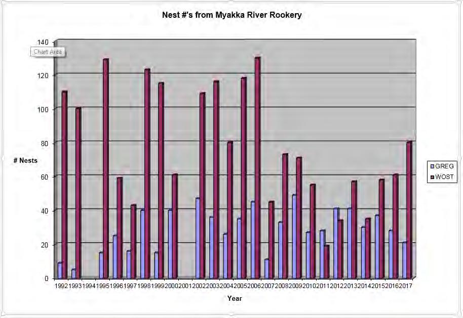
8 As in previous years, the CWA (Myakka Rookery) was monitored during monthly wildlife surveys. (See graph of estimated nesting by MWSR Program on the following page.) 8
9 9
10 Table 1: Summary of Island Apple Snail Activities Location (Upper Lake, River north of Park Bridge, Lower Lake) As much information as possible. Number of Exotic Snail Egg Clusters Present Number of Exotic Snail Egg Clusters Removed hours spent (total* hours) Date Observer(s) 3/8/2017 Chris Oliver, Bain Ball Pavilion area to LML /8/2017 Chris Oliver, Bain Ball Dam to Border Road /28/2017 Chris Oliver, Bain Ball CR780 to UML /8/2017 Chris Oliver, Bain Ball Dam to Border Road /3/2017 Chris Oliver Big Flats Marsh (BFM) /18/2017 Chris Oliver Big Flats Marsh (BFM) /25/2017 Chris Oliver, Bain Ball Clay Gully are April Bain Ball UML to S.R /2/2017 Chris Oliver Deer Prairie Slough /10/2017 Chris Oliver, Kris Fehlberg, Lee Amos Dam to Border Road /26/2017 Chris Oliver Big Flats Marsh (BFM) May Bain Ball UML to S.R /16/2017 Chris Oliver, Bain Ball CR780 to UML /16/2017 Chris Oliver, Bain Ball Weir to park bridge /17/2017 Chris Oliver, Kris Fehlberg, Bain Ball Dam to Border Road /13/2017 Chris Oliver, Bain Ball Weir to park bridge /21/2017 Chris Oliver, Bain Ball, Jenny Jones Park Bridge to Pavilion /17/2017 Chris Oliver, Bain Ball Park Bridge to Pavilion /17/2017 Chris Oliver, Bain Ball Pavilion area to LML /17/2017 Chris Oliver, Bain Ball Deep Hole to (Down's) Dam /17/2017 Chris Oliver, Bain Ball Dam to Border Road /30/2017 Chris Oliver, Bain Ball CR780 to UML /30/2017 Chris Oliver, Bain Ball Weir to Park Bridge /20/2017 Chris Oliver, Bain Ball Pavilion area to LML /20/2017 Chris Oliver, Bain Ball Deep Hole to (Down's) Dam /20/2017 Chris Oliver, Bain Ball Dam to Border Road /1/2017 Chris Oliver, Bain Ball CR780 to UML /1/2017 Chris Oliver, Bain Ball Weir to park bridge TOTALS:
Jackson Bottom Wetlands Preserve BCS Number: 47-14
 Jackson Bottom Wetlands Preserve BCS Number: 47-14 Site description author(s) Greg Gillson, Jackson Bottom Wetlands Preserve Primary contact for this site Ed Becker, Natural Resources Manager, Jackson
Sauvie Island Wildlife Area BCS number: 47-28
 Sauvie Island Wildlife Area BCS number: 47-28 Site description author(s) Mark Nebeker, Oregon Department of Fish and Wildlife, Sauvie Island Wildlife Area Manager Primary contact for this site Mark Nebeker,
Division: Habitat and Species Conservation Authors: Claire Sunquist Blunden and Brad Gruver
 Division: Habitat and Species Conservation Authors: Claire Sunquist Blunden and Brad Gruver Report date: December 13, 2018 All photos by FWC unless otherwise acknowledged Presenting 6 new guidelines 1
Matagorda Island Marsh Restoration An Adaptive Management Approach by Coastal Bend Bays & Estuaries Program
 Matagorda Island Marsh Restoration An Adaptive Management Approach by Coastal Bend Bays & Estuaries Program 1957: After Levees 1930: Before Levees Matagorda Island: Site Location Texas Coastal Bend Calhoun
Northern Remnant of the. Everglades Ecosystem. Sylvia R. Pelizza
 Arthur R. Marshall Loxahatchee Nation nal Wildlife Refuge Northern Remnant of the Everglades Ecosystem Sylvia R. Pelizza Project tleader National Wildli fe Refuge System Administered i d by the U.S. Fish
FWC Proposed CWA s in Southwest Florida Could Impact Boa;ng
 FWC Proposed CWA s in Southwest Florida Could Impact Boa;ng CWAs (Cri)cal Wildlife Area s) are established by FWC to protect important concentra)ons of wildlife and manage human ac)vi)es to minimize and
McKay Creek National Wildlife Refuge BCS number: 48-19
 Oregon Coordinated Aquatic Bird Monitoring: Description of Important Aquatic Bird Site McKay Creek National Wildlife Refuge BCS number: 48-19 Site description author(s) Howard Browers, Supervisory Wildlife
2012 Wading Bird Nesting in the Everglades
 Wading Bird Nesting in the Everglades Large scale Restoration Needed to Recover Wading Bird Populations Introduction The annual South Florida Wading Bird Report 1 provides an overview of wading bird nesting
2016 Nature Mapping Jackson Hole Snake River Float Trip Annual Report
 216 Nature Mapping Jackson Hole Snake River Float Trip Annual Report Compiled by Tim E. Griffith: November 22, 216 OVERVIEW 216 was a very exciting year for the Nature Mapping Jackson Hole Snake River
Florida Keys National Wildlife Refuge Complex. Key West NWR Great White Heron NWR National Key Deer NWR Crocodile Lake NWR
 Florida Keys National Wildlife Refuge Complex Key West NWR Great White Heron NWR National Key Deer NWR Crocodile Lake NWR Key West NWR Marquesas Keys and 13 other keys Mission as a preserve and protect
Expansion Work Has Begun The perimeter dike for Cell 7 is now visible
 Summer/Fall 2017 In This Issue Poplar Island Expansion Wetland Cell 5AB Development Wildlife Update Birding tours on Poplar Island Expansion Work Has Begun The perimeter dike for Cell 7 is now visible
Florida Birds East Coast
 Florida Birds East Coast The very best place to see and photograph birds and other wildlife during the frigid northern winter months is warm, sunny Florida. It s at this time of year that the flow of people
Rocky Reach Wildlife Forum 2017 Wildlife Monitoring Proposal FINAL
 Rocky Reach Wildlife Forum 2017 Wildlife Monitoring Proposal FINAL Background January 13, 2017 During the Rocky Reach Hydroelectric Project (Project 2145) relicensing process, the Public Utility District
Resilient Birds, Devoted Advocates 2016 Coastal Bird Conservation Results. Spring American Oystercatcher Photo by Matt Filosa
 Resilient Birds, Devoted Advocates 2016 Coastal Bird Conservation Results Spring 2017 American Oystercatcher Photo by Matt Filosa Florida s coastal birds face long odds, but Audubon support gives them
Klamath Marsh National Wildlife Refuge BCS number: 48-16
 Oregon Coordinated Aquatic Bird Monitoring: Description of Important Aquatic Bird Site Klamath Marsh National Wildlife Refuge BCS number: 48-16 Site description author(s) Carol Damberg, Klamath Marsh NWR
Smith and Bybee Wetlands Natural Area BCS number 47-33
 Smith and Bybee Wetlands Natural Area BCS number 47-33 Site description author(s) Elaine Stewart, Smith and Bybee Lakes Wildlife Area Manager Danielle Morris, Research and Monitoring Team, Klamath Bird
BALD EAGLE MANAGEMENT 2014 ANNUAL REPORT
 SETTLEMENT AGREEMENT ARTICLE 513 BALD EAGLE MANAGEMENT 2014 ANNUAL REPORT REPORTING PERIOD JANUARY 1 DECEMBER 31, 2014 BAKER RIVER HYDROELECTRIC PROJECT FERC No. 2150 September 2015 PUGET SOUND ENERGY
Baskett Slough National Wildlife Refuge BCS number: 47-4
 Baskett Slough National Wildlife Refuge BCS number: 47-4 Site description author(s) Daphne E. Swope, Research and Monitoring Team, Klamath Bird Observatory Primary contact for this site N/A Location (UTM)
OVERVIEW INTRODUCTION TO SHOREBIRDS MANAGEMENT FOR SHOREBIRDS TVA REGIONAL SHOREBIRD PROJECT ESTIMATING SHOREBIRD NUMBERS
 SHOREBIRD CONSERVATION AND MONITORING RESOURCES US SHOREBIRD CONSERVATOIN PLAN http://www.fws.gov/shorebirdplan WATERFOWL MANAGEMENT HANDBOOK - http://www.nwrc.usgs.gov/wdb/pub/wmh/contents.html MANOMET
Fernhill Wetlands BCS number: 47-13
 Fernhill Wetlands BCS number: 47-13 ***NOTE: We were unable to determine all necessary information for this site description. If you would like to contribute the needed information to this description,
Oregon Dunes National Recreation Area BCS Number: 47-5
 Oregon Dunes National Recreation Area BCS Number: 47-5 ***NOTE: We were unable to determine all necessary information for this site description. If you would like to contribute the needed information to
Mud Slough Wetland Reserve BCS number: 47-19
 Mud Slough Wetland Reserve BCS number: 47-19 ***NOTE: We were unable to determine all necessary information for this site description. If you would like to contribute the needed information to this description,
River s End Ranch BCS number: 48-21
 Oregon Coordinated Aquatic Bird Monitoring: Description of Important Aquatic Bird Site River s End Ranch BCS number: 48-21 Site description author(s) Martin St. Lewis, Area Manager, Summer Lake Wildlife
Siletz Bay BCS number: 47-29
 Siletz Bay BCS number: 47-29 ***NOTE: We were unable to determine all necessary information for this site description. If you would like to contribute the needed information to this description, please
ZELLWOOD BIRD COUNTS JUNE, 2016
 ZELLWOOD BIRD COUNTS JUNE, 2016 June is often one of the quiet months but it does have the habit of turning up the unexpected so read on. There were four Roseate Spoonbills on the 21 st with an adult staying
Listed Birds along the Stony Brook Corridor Impacted by BMS Zoning Change
 Listed Birds along the Stony Brook Corridor Impacted by BMS Zoning Change Washington Crossing Audubon Society (WCAS) opposes the zoning change to allow high density housing on the Bristol-Meyers Squibb
Black-crowned Night-heron Minnesota Conservation Summary
 Credit Deborah Reynolds Black-crowned Night-heron Minnesota Conservation Summary Audubon Minnesota Spring 2014 The Blueprint for Minnesota Bird Conservation is a project of Audubon Minnesota written by
2008 San Francisco Bay Shorebird Census
 2008 San Francisco Bay Shorebird Census San Francisco Bay is a great place for shorebirds! The salt ponds, tidal flats, marshes and seasonal wetlands provide important habitat for over a million resident
Upper Klamath National Wildlife Refuge Complex Upper Klamath Unit and Hank s Marsh Unit BCS Number: 48-29
 Oregon Coordinated Aquatic Bird Monitoring: Description of Important Aquatic Bird Site Upper Klamath National Wildlife Refuge Complex Upper Klamath Unit and Hank s Marsh Unit BCS Number: 48-29 Site description
LOON FLOATING NEST PLATFORMS 2014 ANNUAL REPORT
 SETTLEMENT AGREEMENT ARTICLE 507 LOON FLOATING NEST PLATFORMS 2014 ANNUAL REPORT REPORTING PERIOD JANUARY 1 DECEMBER 31, 2014 BAKER RIVER HYDROELECTRIC PROJECT FERC No. 2150 September 2015 PUGET SOUND
TWIN ISLES COUNTRY CLUB AUDUBON COOPERATIVE SANCTUARY PROGRAM
 TWIN ISLES COUNTRY CLUB AUDUBON COOPERATIVE SANCTUARY PROGRAM What is the Audubon Cooperative Sanctuary Program? The Audubon Cooperative Sanctuary Program helps golf courses to enhance wildlife habitats
Geographic Response Plan Map: SFL-31. Bradley. Map continued Key on: SFL-34. Key. Murray Key XXX SFL Clive Key XXX. SFL31-06 Clive Key
 ! 1550 1450 81 0'0"W # [\ m [] Geographic Response Plan Map: SFL-31 Bradley Map continued on: SFL-34 Jow Kemp Florida Bay 80 52'30"W 25 7'30"N 1550 1350 SFL31-01 Conchie Channel SFL31-02 Oyster Oyster
TAMU-CC Hike & Bike Trail Revitalization Sub-Committee. TAMU-CC Environmental Advisory Council FY 2009
 TAMU-CC Hike & Bike Trail Revitalization Sub-Committee TAMU-CC Environmental Advisory Council FY 2009 Site Description http://lighthouse.tamucc.edu/chr/wardisland Ward Island bordered by Corpus Christi
Killin Wetland (Cedar Canyon Marsh) BCS number: 47-15
 BCS number: 47-15") Killin Wetland (Cedar Canyon Marsh) BCS number: 47-15 ***NOTE: We were unable to determine all necessary information for this site description. If you would like to contribute the needed information to
Killin Wetland (Cedar Canyon Marsh) BCS number: 47-15 ***NOTE: We were unable to determine all necessary information for this site description. If you would like to contribute the needed information to
Siuslaw River Estuary BCS number 47-32
 Siuslaw River Estuary BCS number 47-32 Site description author(s) Daphne E. Swope, Research and Monitoring Team, Klamath Bird Observatory Primary contact for this site Liz Vollmer, Siuslaw Watershed Council
Tahkenitch Creek Estuary BCS number: 47-35
 Tahkenitch Creek Estuary BCS number: 47-35 ***NOTE: We were unable to determine all necessary information for this site description. If you would like to contribute the needed information to this description,
Wood Stork Nesting Population Survey Results 2016 and Radio-tracking Dice
 Wood Stork Nesting Population Survey Results 2016 and Radio-tracking Dice Sara H. Schweitzer Wildlife Diversity Program North Carolina Wildlife Resources Commission Annika Anderson and Edye Kornegay (NCWRC)
US Army Corps of Engineers Rock Island District
 US Army Corps of Engineers Rock Island District Compiled by Marsha Dolan March 2014 The American Bald Eagle: Natural History & Current Conditions The bald eagle has proudly served as the emblem for the
Smith River Mouth BCS number: 86-6
 Smith River Mouth BCS number: 86-6 ***NOTE: We were unable to determine all necessary information for this site description. If you would like to contribute the needed information to this description,
CDOW Recommended Stipulations for Oil and Gas Within the State of Colorado
 CDOW Recommended Stipulations for Oil and Gas Within the State of Colorado No Surface Occupancy Timing Limitation Controlled Surface Use Stipulation Stipulation Stipulation Wildlife Habitat Species Types
Alvord Lake BCS number: 48-2
 Oregon Coordinated Aquatic Bird Monitoring: Description of Important Aquatic Bird Site Alvord Lake BCS number: 48-2 Site description author(s) Whitney Haskell, Data Management Intern, Klamath Bird Observatory
Tualatin River NWR and Wapato Lake BCS number: 47-37
 Tualatin River NWR and Wapato Lake BCS number: 47-37 ***NOTE: We were unable to determine all necessary information for this site description. If you would like to contribute the needed information to
Whittlesey & Drysides IDB Biodiversity Action Plan Report Drainage Ditch Action Plan
 Whittlesey & Drysides IDB Biodiversity Plan Report 04-5 Drainage Ditch Plan Manage ditches for biodiversity as well as for drainage Identify ditches of conservation interest and manage appropriately Support
Snake River Float Trips 2017 Annual Report
 Snake River Float Trips 2017 Annual Report Compiled by Tim E. Griffith April 2018 OVERVIEW 2017 was a very challenging year for the Nature Mapping Jackson Hole (NMJH) Snake River Float Trips. A higher-than-normal
Geographic Response Plan Map: SC-56. Map Continued on SC-50 XXX. Fripps Inlet. Raptor Nesting Area. Recreational Fishing. Sea Turtles.
 32 22'30"N Map Continued on SC-55 80 30'0"W X ull et SC56-01 Story/Harbor River Junction Story River!h!S(!d Old House Creek 1050 [ 400 1000 SC56-03 Old House Creek «Geographic Response Plan Map: SC-56
Beaver Island Archipelago: Invasive Species Control Final Report Submitted by:
 Beaver Island Archipelago: Invasive Species Control Final Report Submitted by: 4371 N Long Lake Rd Traverse City, MI 49684 wildlife@wildlifewetlands.com (231) 943-0762 Project Plan and Schedule 2014 Treatment
Into THE WILD CUB SCOUT- Webelo
 Into THE WILD CUB SCOUT- Webelo Klehm Arboretum & Botanic Garden Requirements Into the Wild is one of the Webelo CORE Adventure Requirements. For this adventure, scouts and their adult partners learn some
WATER BIRDS OF PALM BEACH COUNTY
 WATER BIRDS OF PALM BEACH COUNTY Presented by : The Audubon Society of the Everglades www.auduboneverglades.org Text and Photographs by Larry Hess Types of Water Birds Seen in Palm Beach County Ducks and
Wildlife Hazard Management. Brisbane Airport
 Wildlife Hazard Management Brisbane Airport This Presentation Our approach Off-airport hazards On-airport hazards Wildlife Hazard Management Plan Grassland Monoculture Research Project Drainage works Other
Wildlife Habitat Monitoring and Information and Education Program Progress Report
 Priest Rapids Hydroelectric Project (FERC No. 2114) Wildlife Habitat Monitoring and Information and Education Program 2013 Progress Report License Article 410 December 2013 Executive Summary On October
Geographic Response Plan Map: GA-2. Raptor Nesting Area. Recreational Fishing. Sea Turtles. Shorebird Nesting Area. Wading birds Nesting Area
 81 7'30"W Geographic Response Plan Map: GA-2 81 0'0"W 32 15'0"N 32 15'0"N Union Creek «46 Jasper Beaufort «170 Sector Charleston Sava n nah «170 and 2 AH NATIONAL FE REFUGE Middle River GA1-07 Steam Boat
HUNGRYLAND BIRD LIST
 HUNGRYLAND BIRD LIST Jones/Hungryland Wildlife and Environmental Area Symbols Used in This Checklist Type Seasons species confirmed on this site species probably occurs on this site, based on habitat,
4-H Conservation Guidelines
 4-H Conservation Guidelines The following are guidelines for providing learning experiences in the conservation project area. THE GUIDELINES FOR ALL MEMBERS Understand what Natural Resources are; how to
1313 Sherman Street, Room 618 Denver, Colorado Phone (303) FAX (303) wildlife.state.co.us parks.state.co.
 FAX (303) wildlife.state.co.us parks.state.co.") COLORADO S & WILDLIFE 1313 Sherman Street, Room 618 Denver, Colorado 80203 Phone (303) 866-3437 FAX (303) 866-3206 wildlife.state.co.us parks.state.co.us MEMORANDUM Date: To: From: Re: August 29, 2013
COLORADO S & WILDLIFE 1313 Sherman Street, Room 618 Denver, Colorado 80203 Phone (303) 866-3437 FAX (303) 866-3206 wildlife.state.co.us parks.state.co.us MEMORANDUM Date: To: From: Re: August 29, 2013
US Army Corps of Engineers Rock Island District
 US Army Corps of Engineers Rock Island District Compiled by Davi Michl March 218 The American Bald Eagle: 2 Natural History & Current Conditions The bald eagle has proudly served as the emblem for the
McNabney Marsh Nesting Bird Surveys
 McNabney Marsh 2014 Nesting Bird Surveys Prepared for: Mt View Sanitary District PO Box 2757 Martinez, CA 94553 Contact: Kelly Davidson 925.228.5635 Prepared by: PO Box 188888 Sacramento, CA 95818 Contact:
Catch the Citizen Science Buzz!
 Catch the Citizen Science Buzz! Utilizing Citizen Science to Inform Land Management Decisions Tina Stephens, Volunteer and Outreach Coordinator Becky Gajewski, Stewardship Specialist Why are you here?
Picayune Strand Restoration Project in Southwest Florida A Landscape Perspective
 U.S. Fish and Wildlife Service Restoring America s Everglades-Recovering Multiple Species Picayune Strand Restoration Project in Southwest Florida A Landscape Perspective Kim Dryden U.S. Fish and Wildlife
TAS: Hillend - Bob Elliston
 1 / 5 TAS: Hillend - Bob Elliston "Hillend" is a 60 hectare property situated on North Bruny Island. It is a dedicated wildlife sanctuary and it is also a residence owned by Bob Elliston. It is Bob's intention
Spring-Summer Issue 66. The Great Egg Harbor Watershed Association s website has a new look. Check us out.
 Spring-Summer 2015 www.gehwa.org Issue 66 The Great Egg Harbor Watershed Association s website has a new look. Check us out. National Park Foundation 2014 Impact Grant In 2014 the National Park Foundation,
CORE *REQUIRED OF ALL COMMUNITIES* CIIY TOWN COUNIY YES YES YES YES YES
 CORE *REQUIRED OF ALL COMMUNITIES* ACTIVIIY COUNIY CIIY SEMI 1. Host a Community Wildlife Project Meeting 2. Add at least 4 books or videos dealing with wildlife or wildlife conservation to a school or
Marine Corps Support Facility-Blount Island: Integrated Natural Resources Program Successes. E2S2 Conference May 12, 2011
 Marine Corps Support Facility-Blount Island: Integrated Natural Resources Program Successes E2S2 Conference May 12, 2011 Shari Kennedy, MCSF-BI Robert Price, CH2M HILL Location Mission The mission of Marine
National Audubon Society. Coastal Bird Conservation Program
 National Audubon Society Coastal Bird Conservation Program Coastal Bird Conservation Program This presentation contains original photos and data. For any use of this information, data, maps, or photographs
Backcountry Management. Anne Morkill Wildlife Refuge Manager U.S. Fish & Wildlife Service
 Backcountry Management Anne Morkill Wildlife Refuge Manager U.S. Fish & Wildlife Service Florida Keys National Marine Sanctuary Advisory Council Duck Key, FL February 21, 2012 Overview of National Wildlife
Bald Eagle Annual Report February 1, 2016
 Bald Eagle Annual Report 2015 February 1, 2016 This page intentionally blank. PROJECT SUMMARY Project Title: Bald Eagle HCP Monitoring Subject Area: Habitat Conservation Plan (HCP) monitoring Date initiated:
Bucks Creek Hydroelectric Project, FERC Project No. 619 Revised Study Plan
 Revised Study Plan RTE-S2 STUDY GOAL AND OBJECTIVE STUDY DESCRIPTION RTE-S2 BALD EAGLE & OSPREY September 2014 (Revised February 2015) The Bucks Creek Project (Project) Pre-Application Document (PAD) (November
Malheur National Wildlife Refuge BCS number: 48-18
 Oregon Coordinated Aquatic Bird Monitoring: Description of Important Aquatic Bird Site Malheur National Wildlife Refuge BCS number: 48-18 Site description author(s) Sally Hall, Volunteer, Malheur NWR Roger
CHAPTER. Coastal Birds CONTENTS. Introduction Coastal Birds Action Plan. 108 cbbep.org
 CHAPTER 9 Coastal Birds CONTENTS Introduction Coastal Birds Action Plan 108 cbbep.org Introduction The South Texas coast is one of the most unique areas in North America and is renowned for its exceptional
Wildlife Habitat Management on State Forest and Wildlife Lands
 Wildlife Habitat Management on State Forest and Wildlife Lands State Forests are managed within a sustainable forestry framework under an approved management plan. Sustainability includes managing the
Protecting our Natural Areas from Phragmites and other Invaders
 Protecting our Natural Areas from Phragmites and other Invaders by Laurie Kaufman www.stewardshipnetwork.org/midmich Asclepias incarnata, photo by Laurie Kaufman What do we mean by Invasive Species? The
Protecting Beach-nesting Birds in Louisiana VOLUNTEER TRAINING
 Protecting Beach-nesting Birds in Louisiana VOLUNTEER TRAINING How Many Bird Species in Louisiana? a. 120 b. 280 c. 480 Year-round Residents Nearctic-Neotropic Migrants W. Dave Patton Eric Liffmann Winter
Wulfert Bayous Land Acquisition Campaign. Preserve. Protect. Inspire. Ding Darling Wildlife Society
 Wulfert Bayous Land Acquisition Campaign Preserve. Protect. Inspire. Ding Darling Wildlife Society Project Overview Wulfert Bayous is the largest unprotected property on Sanibel Island, and is adjacent
Geographic [x Response Plan Map: GA-12 [r. Map Continued on GA-8 XXX. GA12-01 Green Island Sound. OSSABAW ISLAND WMA Raccoon Key XXX
 Charles Ogeechee River tal Waterway 31 52'30"N Little Ogeechee River Harveys Island 81 7'30"W Charles Rush Charles 950 Ogeechee River Geographic Response Plan Map: GA-12 Map Continued on GA-8 Green Island
Second Term Extra Credit: Bald Eagle Field Study America s most prestigious bird of prey
 Second Term Extra Credit: Bald Eagle Field Study America s most prestigious bird of prey Name: Hour: Field Dates: Pre-field study done: Arrival time: Saturday, January 8 8:00 10:00 AM (in conjunction w/
2011 Wood River Wetland Yellow Rail (Coturnicops neveboracensis noveboracensis) Survey Report
 Survey Report") 2011 Wood River Wetland Yellow Rail (Coturnicops neveboracensis noveboracensis) Survey Report Project Description The Bureau of Land Management s Wood River Wetland is located in T34S-R 7 1/2E; the wetland
2011 Wood River Wetland Yellow Rail (Coturnicops neveboracensis noveboracensis) Survey Report Project Description The Bureau of Land Management s Wood River Wetland is located in T34S-R 7 1/2E; the wetland
Ladd Marsh Wildlife Area BCS number: 49-3
 Oregon Coordinated Aquatic Bird Monitoring: Description of Important Aquatic Bird Site Ladd Marsh Wildlife Area BCS number: 49-3 Site description author M. Cathy Nowak, Ladd Marsh Wildlife Area Biologist
Las Vegas Wash Coordination Committee Environmental Update
 Las Vegas Wash Coordination Committee Environmental Update April 2018 Threatened and Endangered Species Surveys 2017 Final Reports all posted at lvwash.org Marsh birds Yellow-billed cuckoo Southwestern
Site Description: Gull Rock is located approximately 0.4 miles offshore and about six miles north of Yaquina Head in Lincoln County, Oregon.
 Devil s Punchbowl intertidal area Gull Rock (offshore) 12. Gull Rock Site Description: Gull Rock is located approximately 0.4 miles offshore and about six miles north of Yaquina Head in Lincoln County,
18 July Keith Greer SANDAG 401 B Street, Suite 800 San Diego, CA Subject: Mission Bay Park Project Quarterly Report
 18 July 2012 Keith Greer SANDAG 401 B Street, Suite 800 San Diego, CA 92101 Subject: Mission Bay Park Project Quarterly Report Dates Reporting: April 6 th -July 6 th, 2012 Project Summary: The project
APPENDIX A ANNUAL COMPLIANCE REPORT CONDITION REQUIREMENTS CONDITION 4.0
 APPENDIX A ANNUAL COMPLIANCE REPORT CONDITION REQUIREMENTS CONDITION 4.0 Condition 4: Migratory Birds 4.1.1 The Proponent shall carry out all phases of the Designated Project in a manner that avoids harming
BYRON BIRD BUDDIES. ANNUAL REPORT September 2015 September 2016
 BYRON BIRD BUDDIES ANNUAL REPORT September 2015 September 2016 Byron Bird Buddies (BBB) is a small, self funded community education and conservation group focusing on the preservation of habitat for resident
Tiered Species Habitats (Terrestrial and Aquatic)
") Tiered Species Habitats (Terrestrial and Aquatic) Dataset Description Free-Bridge Area Map The Department of Game and Inland Fisheries (DGIF s) Tiered Species Habitat data shows the number of Tier 1, 2
Tiered Species Habitats (Terrestrial and Aquatic) Dataset Description Free-Bridge Area Map The Department of Game and Inland Fisheries (DGIF s) Tiered Species Habitat data shows the number of Tier 1, 2
Coos Bay BCS number: 47-8
 Coos Bay BCS number: 47-8 ***NOTE: The completion of this site description is still in progress by our Primary Contact (listed below). However, if you would like to contribute additional information to
PENNSYLVANIA GAME COMMISSION BUREAU OF WILDLIFE MANAGEMENT RESEARCH DIVISION PROJECT ANNUAL JOB REPORT
 PENNSYLVANIA GAME COMMISSION BUREAU OF WILDLIFE MANAGEMENT RESEARCH DIVISION PROJECT ANNUAL JOB REPORT PROJECT CODE NO.: 06750 TITLE: Nongame Wildlife Research/Management JOB CODE NO.: 70004 TITLE: Colonial
Warner Wetlands / Warner Valley BCS number: 48-31
 Oregon Coordinated Aquatic Bird Monitoring: Description of Important Aquatic Bird Site Warner Wetlands / Warner Valley BCS number: 48-31 Site description author(s) Vernon Stofleth, Lakeview BLM District
California Least Tern & Western Snowy Plover Monitoring Project. Huntington State Beach Least Tern Natural Preserve A Partnership Since 2005
 California Least Tern & Western Snowy Plover Monitoring Project Huntington State Beach Least Tern Natural Preserve A Partnership Since 2005 Identification California Least Tern - CLTE Endangered 9-10 Nests
PLAN B Natural Heritage
 City of Brantford Waterfront Master Plan Bald Eagle Habitat Management Recommendations - DRAFT Introduction In 2009, a pair of bald eagles (Haliaetus leucocephalus) attempted to nest in a large Cottonwood
BALD EAGLE MANAGEMENT 2012 ANNUAL REPORT
 SETTLEMENT AGREEMENT ARTICLE 513 BALD EAGLE MANAGEMENT 2012 ANNUAL REPORT REPORTING PERIOD JANUARY 1 DECEMBER 31, 2012 BAKER RIVER HYDROELECTRIC PROJECT FERC No. 2150 April 2014 BAK SA 513 Annual Report
2017 Annual Volunteer Report
 2017 Annual Volunteer Report Volunteer Statistics Summary 23,164 DNR 280,419 Hours Donated 135 FTE s (Full Time Equivalents based on a 40-hour work week or 2,080 hours/year.) Volunteer hours are equivalent
Bird Watch. Inform ation You Need to K now for Nesting Se a son
 Bird Watch Inform ation You Need to K now for Nesting Se a son Contents Overview of American Tower s Bird Site Practices 3 Bird Site Treatment Protocol 4 American Tower s Eagle Nest Policy 4 American Tower
Habitat Use by Wildlife in Agricultural and Ranching Areas in the Pantanal and Everglades. Dr. Júlio Cesar de Souza and Dr. Elise V.
 Habitat Use by Wildlife in Agricultural and Ranching Areas in the Pantanal and Everglades Dr. Júlio Cesar de Souza and Dr. Elise V. Pearlstine Pantanal 140,000 km 2 of wetlands with a monomodal flood pulse
Mystic Lake Hydroelectric Project FERC Project Number Year Bald Eagle Monitoring Summary Report Public
 Mystic Hydroelectric Project FERC Project Number 2301 3-Year Bald Eagle Monitoring Summary Report 2010-2013 Public 2013 by PPL Montana, LLC. ALL RIGHTS RESERVED Submitted to: Federal Energy Regulatory
FRIENDS MATTER. Celebrating Celery Fields. Friends of the Tampa Bay National Wildlife Refuges
 FRIENDS MATTER Celebrating Celery Fields Photo by Dave Howard Did you know that Sarasota County s primary storm-water management area is also a very important bird sanctuary managed by the Florida Audubon
Humboldt Bay NWR BCS number: 86-4
 Humboldt Bay NWR BCS number: 86-4 ***NOTE: We were unable to determine all necessary information for this site description. If you would like to contribute the needed information to this description, please
American White Pelican Minnesota Conservation Summary
 Credit Carrol Henderson American White Pelican Minnesota Conservation Summary Audubon Minnesota Spring 2014 The Blueprint for Minnesota Bird Conservation is a project of Audubon Minnesota written by Lee
Erie County Van Trip. Pipe Creek Wildlife Area
 Erie County Van Trip ***See red markings on maps indicating the best birding options at each location. Please note that you are not limited to these areas, they are just the areas we feel will be most
Key Findings of the 2017 South Florida Wading Bird Report
 The 2017 wading bird nesting season produced some of the highest nest counts in a decade, with a total of 46,248 nests which represents a moderate improvement from the 10-year annual average of 39,065
Spring 2018 PERSEVERANCE. Birds and Stewards Weather Record Storms Coastal Bird Conservation Results. Least Tern Chick Photo: Jim Verhagen
 Spring 2018 PERSEVERANCE Birds and Stewards Weather Record Storms 2017 Coastal Bird Conservation Results Least Tern Chick Photo: Jim Verhagen Audubon Florida s Dynamic Coastal Team Reports Good Year for
Toronto s Urban Wilderness
 Tommy Thompson Park Toronto s Urban Wilderness Park History Early Construction Construction began in 1959 by Toronto Harbour Commissioners Expand port related facilities Dispose of rubble and fill from
Cat Island Chain Restoration Project Brown County Port & Resource Recovery Department
 Cat Island Chain Restoration Project Brown County Port & Resource Recovery Department February 2, 2015 Fox River and Lower Green Bay Cat Island Chain - 1938 Cat Island Brown County Aerial Photography,