Tributary Access and Potential Fish Stranding
|
|
|
- Beverly Lindsey
- 5 years ago
- Views:
Transcription
1 Falls River Project Water Use Plan Tributary Access and Potential Fish Stranding Implementation Year 1 Reference: FLSMON-3 Falls River Water Use Plan Monitoring Program: Tributary Access and Potential Fish Stranding Study Period: Cambria Gordon Ltd. Metlakatla Fisheries August 2010

2 BC Hydro Falls River Water Use Plan (WUP): Tributary Access and Potential Fish Stranding Final Report Prepared for: BC Hydro Attn: Eva Wichmann 10 John Hart Road Campbell River, BC V9H 1P1 August 2010 Prepared by: Jordan Beblow, RPBio.
3 Tributary Access and Potential Fish Stranding Falls River WUP August 2010 Acknowledgments We would like to thank Eva Wichmann and Mike McArthur of BC Hydro for their support and valuable input throughout this project. William Beynon, Michelle Mintenko, Lindsay Mickelson, Dave Taft, and Miranda Schulz, provided thoughtful and timely assistance throughout the project. Andrew Thomas of BC Hydro (Terrace) provided ongoing logistical support for our field crews. Additional thanks must go to the crew at Inland Air for their flying expertise to Falls River. v
4 Tributary Access and Potential Fish Stranding Falls River WUP August 2010 Executive Summary In 2009 and 2010, Cambria Gordon Ltd. (CGL) and Metlakatla Fisheries completed surveys in the Falls River reservoir, Falls River and Carthew and Hayward Creeks, in order to fulfill a component of BC Hydro s Water Licence. This report summarizes the one-year study and also provides an overall summary for the monitoring project; a component of a larger 5-year Water Use Plan (WUP) monitoring program. Main Objectives The ultimate objective of the study was to assess the outcome of recommended operational changes (changes in flow regimes) to provide information on which to base future operational decisions, as outlined in the Falls River Project WUP Monitoring Program Terms of Reference (ToR) (BC Hydro, 2006). The following report outlines efforts to assist BC Hydro to answer two key management questions identified in the Falls River WUP: 1. Are there migration barriers in tributaries within the potential drawdown zone of Big Falls Reservoir? 2. Are there locations where fish could be stranded along the Big Falls Reservoir shoreline? This study represents one of several monitoring programs recommended by the Consultative Committee (BC Hydro, 2003) conducted according to the Falls River Order under the Water Act (Controller of Water Rights, 2006). Critical Methods The drawdown zone of the Big Falls River reservoir (<92.4 m above sea level - ASL) was delineated on aerial photomosaics to display the extent of potential flooding in the reservoir (including Falls River and Carthew Creek). In addition the low reservoir water level (i.e., 88.4 m ASL) was also delineated on an aerial photomosaic, using a bathymetry map created by Larratt Aquatic Consulting Ltd (1983), in conjunction with surveyed elevation points gathered in the field. To evaluate the presence/absence of barriers to fish migration and potential stranding areas in Falls River and Carthew and Hayward Creeks, ground-truthing (boat survey, wading) was conducted on May 13-14, 2009, November 17, 2009 and April 13, On April 14, 2010, low level photographs were taken from a Dehavilland Beaver float plane, during an over-flight of the reservoir and project footprint. In addition, low-level aerial photomosaics of the reservoir and tributaries (taken on September 10, 2007) were analyzed. In order to evaluate if barrier(s) to adult fish migration in tributaries at elevations near or below 88.4 m ASL exist; the water level of the reservoir was attained on the morning of each field day. The reservoir water level attained from BC Hydro was put in context with 88.4 m ASL reservoir water levels (i.e., difference in meters between actual and projected). Potential migration barrier were assessed noting water clarity conditions, stream substrate and stream gradient changes. Crews were assessing for large boulders and bedrock as part of the channel morphology, which could result in abrupt changes in channel elevation at lower reservoir elevations ( 88.4 m ASL). Visual observations of stream substrate were recorded and photodocumentation was taken throughout study areas. vi
5 Tributary Access and Potential Fish Stranding Falls River WUP August 2010 Potential stranding areas were assessed based on areas delineated during a desk-top analysis of aerial photomosaics (taken September 10, 2007) and existing photographs taken as part of two completed monitoring projects in the reservoir.1 Potential stranding areas were assessed, based on comparison of the upper extent of the (92.4 m ASL) drawdown zone, established using rod and level differential levelling (survey level and stadia rod), with lower reservoir elevations (i.e., 90.7 and 88.9 m ASL). Key Results Fish Barriers in Tributary Streams Ground-truthing (boat survey, wading and over-flight) and aerial photo review of the eastern section of the Falls River reservoir, Falls River, and Carthew and Hayward Creek at reservoir elevations from 88.8 to 90.7 m ASL, found no barriers to the upstream migration of fish. Fish Stranding in Big Falls Reservoir Potential stranding areas exist within the drawdown zone of the reservoir under WUP operations. Areas of potential stranding were located from a potential high reservoir elevation of 92.4 m ASL (flashboards installed) and at dropping reservoir elevations (i.e., from 90.7 to 88.9 m ASL). These areas primarily are located where there is no existing channel morphology. These consist of large, gradually sloping vegetated areas that provide good quality fish habitat (flooding vegetation and abundant LWD), located primarily along the eastern end of the reservoir. Mudflat areas, also posing a stranding risk, are not deemed to be areas in which fish would utilize as habitat, and therefore are viewed to be lower risk stranding areas. Other potential stranding areas also exist along Carthew Creek and the south shore of the reservoir. Potential stranding in Hayward Creek is not expected; due to the steep side slopes and relative confinement of the system. Contextualization The Consultative Committee (CC) for the Falls River Water Use Plan (WUP) expressed concern that the operation of the Big Falls Reservoir and associated seasonal reservoir elevations could affect access to tributaries by cutthroat trout and Dolly Varden because migration barriers may be present in the drawdown zone of the reservoir. No barriers to migration exist in the drawdown zone associated with Falls River or Carthew Creek. Neither creek has any geomorphic features that could create a barrier to fish migration at any flow or reservoir level. Hayward Creek does not appear to have a fish barrier within the drawdown zone; however site access considerations prevented ground-truthing of this assessment, which is based from high quality, low-level aerial photographs. This conclusion regarding barriers is substantiated by low level over-flights of these areas when the reservoir was <89 m ASL. 1 CGL and Metlakatla Fisheries, Big Falls Reservoir Wildlife Shoreline Habitat Monitoring (Year 3) CGL and Metlakatla Fisheries, Sedge Habitat Monitoring (Year 1). vii
6 Tributary Access and Potential Fish Stranding Falls River WUP August 2010 The CC was also concerned that rapid drawdowns of the reservoir could strand fish along the reservoir shoreline throughout the drawdown zone. However, areas of potential stranding and the risk of stranding at such sites had not been determined. Potential stranding areas exist within the drawdown zone of the reservoir under WUP operations. These consist of large, gradually sloping vegetated areas located primarily along the eastern end of the reservoir. Other potential stranding areas also exist along Carthew Creek and the south shore of the reservoir. Should the proposed WUP operating regime be implemented (specifically, installation of flashboards and temporary flooding to 92.4 m ASL), further assessment of stranding risk should occur. This assessment should consider: Actual fish use in potential stranding areas (i.e., at the time of year that a drawdown may occur) and Operating regime and range and rate of potential drawdowns (i.e., when flashboards are removed in May, how far and how quickly will the drawdown occur, and how can this be controlled?). viii
7 Tributary Access and Potential Fish Stranding Falls River WUP August 2010 TABLE OF CONTENTS 1 Introduction Location Existing Information Methods Study Area Tributary Access Study Desk top Analysis Survey Timing Field Methods Fish Stranding Study Desktop Analysis Field Methods Results and Discussion Tributary Access Study Study Area Migration Barrier Survey Shoreline Stranding Survey Study Area Potential Stranding Locations Summary Tributary Access Fish Stranding in Big Falls Reservoir References ix
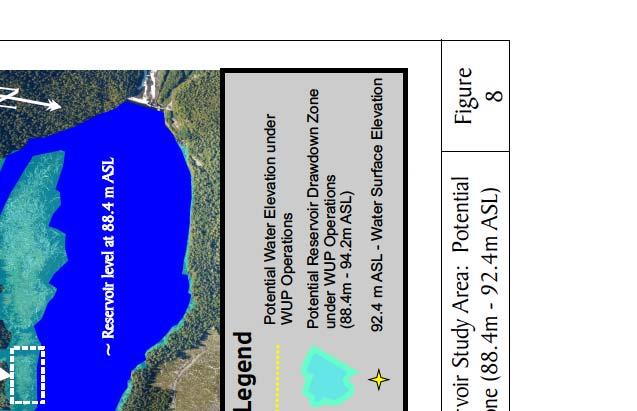
8 Tributary Access and Potential Fish Stranding Falls River WUP August 2010 LIST OF FIGURES Figure 1: Location map, Falls River hydroelectric facility... 3 Figure 2: Reservoir Elevations (m) in the Big Falls Reservoir from 2003 to Figure 3: Big Falls Reservoir, Falls River, Carthew and Hayward Creeks (September 10, 2007) Figure 4: Bathymetry map (Larratt, 1983) overlaid onto aerial photomosaic (CGL, 2007) showing benchmark water surface elevation (90.7 m ASL) and low reservoir elevation (88.4 m ASL) Figure 5: Example of Differential Levelling Methodology (RISC, 2009) Figure 6: Example of a falls, showing outfall drop and plunge pool; a potential barrier to upstream fish migration Figure 7: Channel characteristics in which a potential water velocity barrier may occur: a) channel constriction, b) chute. Both these characteristics are often found together due to the amount of discharge passing through a confined area (i.e., what remains in terms of substrate is large (bedrock and large boulders) Figure 8: Big Falls reservoir study area: potential drawdown zone ( m ASL) Figure 9: Falls River: Migration barrier survey (1) Figure 10: Falls River: Migration barrier survey (2) Figure 11: Falls River: Migration barrier survey (3) Figure 12: Carthew Creek: Migration barrier survey (1) Figure 13: Carthew Creek: Migration barrier survey (2) Figure 14: Carthew Creek: Migration barrier survey (3) Figure 15: Hayward Creek: Migration barrier survey (1) Figure 16: Hayward Creek: Migration barrier survey (2) Figure 17: Hayward Creek: Migration barrier survey (3) Figure 18: Hayward Creek: Migration barrier survey (4) Figure 19: Photo on left shows potential stranding area at the eastern end of the reservoir. Photo on right shows mud flat areas that are low value fish habitat Figure 20: Potential stranding areas (A E) in the drawdown zone Figure 21: Carthew Creek: Potential stranding area E LIST OF TABLES Table 1: Swimming and jumping capabilities of cutthroat/rainbow trout (adapted from Dane 1978 as cited in Whyte et al, 1997) x
9 Tributary Access and Potential Stranding Monitoring Falls River WUP August Introduction Cambria Gordon Ltd. (CGL) and Metlakatla Fisheries were retained by BC Hydro to complete tributary access and potential stranding monitoring at BC Hydro s Falls River hydroelectric project on Big Falls Reservoir. This report summarizes results from a one-year study, which is a component of a larger five-year Water Use Plan (WUP) monitoring program. The Falls River Project facility includes a 154 m long concrete gravity dam located at the top of a large natural waterfall, which creates water storage in the Big Falls reservoir. Two penstocks carry water from the intake at the west end of the reservoir, to a powerhouse located at the base of the falls (Figure 1). The powerhouse contains two turbine units, with a maximum combined discharge of 21.5 m 3 /s. The Falls River project generates approximately 50 GWh/a (gigawatt hours per annum). Excess water is spilled via a free overflow spillway and/or sluice gates when inflows exceed generation and storage capacity The licensed operating range of the reservoir is between 85.5 m and 92.4 m ASL; however, the reservoir is typically operated between 88.4 m and 90.3 m. Flashboards can be manually installed to increase the headpond to 92.4 m and drafting of the reservoir below 88.4 m is restricted to maintain fisheries habitat in the reservoir and ensure sufficient storage to provide downstream fish flows. The timing and duration of flashboard installation and removal, and constraints on total discharge (turbine and spillway flows) can be used to manage the reservoir level to flood sedge habitat, maintain habitat for fish, and ensure sufficient storage for downstream minimum flows. The key management questions are: 1. Are there migration barriers in tributaries within the potential drawdown zone of Big Falls Reservoir? 2. Are there locations where fish could be stranded along the Big Falls Reservoir shoreline? The key water use decision affected by the results of the monitoring program would potentially be the operation of the Big Falls Reservoir, particularly reservoir elevations during spawning periods, and the rate of reservoir drawdown. The primary objective of the monitoring study is to reduce uncertainty related to the presence of migration barriers for adult cutthroat and Dolly Varden, and areas of potential fish stranding in the Big Falls Reservoir. The geographic scope of the monitoring includes the drawdown zone of the Big Falls Reservoir tributaries (elevations <92.4 m). 1.1 Location BC Hydro s Big Falls River Reservoir is located approximately 50 km southeast of Prince Rupert on the Falls River, a right bank tributary to the Ecstall River (Figure 1). The reservoir is located above a large natural waterfall and is fed by three main inlet streams: Hayward Creek, Carthew Creek and the Falls River. The reservoir is relatively small, with a drainage area of approximately 246 km 2 and is subject to a flashy coastal hydrologic cycle (relatively rapid changes in reservoir elevation resulting from heavy precipitation events Figure 2). The water surface of the reservoir covers approximately 340 ha 2, depending on water levels, and is bounded by steep coastal mountains rising directly from the valley bottom (Figure 3). Prepared by Cambria Gordon and Metlakatla Fisheries 1
10 Tributary Access and Potential Stranding Monitoring Falls River WUP August 2010 The reservoir is located within the Coastal Western Hemlock, very wet maritime subzone, and the sub-montane variant (CWHvm1). This zone is characterized by a wet, mild maritime climate and a long growing season (Banner et al, 1993). Biophysical site characteristics, which include high annual precipitation, rich soils and a lengthy growing season, allow for vigorous annual plant growth. Site access is by boat, float plane or helicopter only. Float plane access is restricted at tide heights below 1.5 m. Prepared by Cambria Gordon and Metlakatla Fisheries 2


11

12 Tributary Access and Potential Stranding Monitoring Falls River WUP August 2010 Water level (m) January 1 January 14 Drawdown zone ( m) January 27 February 9 February 22 March 6 March 19 April 1 April 14 April 27 Post-Flashboard Water Levels Spillw ay crest height w ith flashboards (92.4 m) Spillw ay crest height (no flashboards) (90.3 m) Avg. May 10 May 23 June 5 Sluice Gate (87.2 m) June 18 July 1 July 14 July 27 Date August 9 August 22 September 4 September 17 September 30 October 13 October 26 November 8 November 21 December 4 December 17 December 30 Figure 2: Reservoir Elevations (m) in the Big Falls Reservoir from 2003 to Powerhouse and bunkhouse Hayward Creek Carthew Creek Falls River Figure 3: Big Falls Reservoir, Falls River, Carthew and Hayward Creeks (September 10, 2007). Prepared by Cambria Gordon and Metlakatla Fisheries 4
13 Tributary Access and Potential Stranding Monitoring Falls River WUP August Existing Information In 1982, H. M. Larratt Aquatic Consulting Ltd. studied the impact of woody debris and standing trees on the productivity of the Falls River reservoir. As part of the Larratt study, a bathymetric map was compiled from two longitudinal and eleven perpendicular transects of the reservoir, using a Puruno depth sounder. Figure 3 shows the bathymetry map overlaid onto a September 10, 2007 aerial photomosaic (created by Cambria Gordon Ltd), which for the current study, aided in locating potential areas of stranding at the desktop level and annotating the 88.4 m ASL low reservoir elevation. Commencing in 2007, Cambria Gordon Ltd. and Metlakatla Fisheries conducted wildlife shoreline habitat monitoring in the reservoir; with a three year summary report completed in The key objective of the study was to determine whether nests and dens were present below 92.4 m ASL in the drawdown zone and if located, if these nests and dens could be flooded when flashboards are installed in late winter (BC Hydro, 2006). A valuable piece of information obtained from the wildlife shoreline habitat monitoring for this study, is the delineation of the drawdown zone at 92.4 m ASL; providing the extent of potential flooding should flashboards be installed. In 2007, Cambria Gordon Ltd and Metlakatla Fisheries initiated the first year of a two year sedge habitat maintenance monitoring program (year one and five of a five-year WUP monitoring program), looking at reservoir vegetation in the drawdown zone (90.3 to 92.4 m ASL) 3. The primary objective in Year 1 (2007) of the study was to characterize and delineate distinct vegetation communities, with a focus on determining the area of existing sedge habitat, within the Big Falls Reservoir prior to the implementation of the WUP Operations Regime. The sedge habitat maintenance monitoring program provided survey elevations, and photodocumentation, which helped in delineating the upper extent of flooding of the drawdown zone (92.4 m ASL) for this study. Given operational circumstances, follow-up monitoring (year 2 of the study) has been delayed until such time that WUP operations can be initiated, and/or an alternative operating regime or study objectives is defined. 2 Methods 2.1 Study Area Delineation of the drawdown zone (up to 92.4 m ASL) was established using methods adapted from the RISC Manual of British Columbia Hydrometric Standards (March, 2009). Differential levelling (using a survey level instrument and stadia rod) was used to determine the elevation along tributaries in the study area, and a level circuit was run between two stations: 1) the known elevation of the reservoir (90.7 m ASL) on the day of the survey, and 2) the upper limit of the drawdown zone (92.4 m ASL). The known benchmark elevation was established by determining actual water elevation of the reservoir on the survey date (90.7 m ASL on May 13/14, 2009). The benchmark elevation point (90.7 m ASL) was analogous with the upper contour (1 m) interval on the bathymetry map (Larratt, 1983 Figure 4). BC Hydro has an operating water elevation gauge in the reservoir which provides hourly water elevation levels. Water elevation at 08:00 was 90.7 m ASL and this was used as the benchmark elevation for the differential levelling survey. The benchmark elevation location was established on the reservoir at the 2 CGL and Metlakatla Fisheries, Big Falls Reservoir Wildlife Shoreline Habitat Monitoring (Year 3) 3 CGL and Metlakatla Fisheries, Sedge Habitat Monitoring (Year 1). Prepared by Cambria Gordon and Metlakatla Fisheries 5
14 Tributary Access and Potential Stranding Monitoring Falls River WUP August 2010 point where tributaries were no longer backwatered and were influenced by flow (Figure 5). A number of intermediate instrument set-ups were established from the benchmark elevation of 90.7 m ASL up to 92.4 m ASL, to determine elevation at several elevation stations up the tributaries in the study area. The sighting distance for backsights and foresights from the instrument were approximately equal (distance ranged between 50 to 90 m). At the first instrument set-up, the rod was held vertically on the bench mark of known elevation (90.7 m ASL at water s edge) with its face turned to the instrument. The backsight (BS) reading on the rod was added to the known elevation to obtain the height of instrument (HI). Next, the rod person carried the rod past the instrument and proceeded approximately the same number of paces away from the instrument to establish a suitable turning point (TP) or elevation station. The height of the instrument (HI) minus the foresight (FS) rod reading at the turning point (TP) was the calculation used to determine the elevation of the turning point (TP) or elevation station. After the turning point was established, the instrument was carried to the next instrument set-up location. The elevation of the next turning point (TP) or elevation station was determined in the same manner as the first turning point (TP). Elevation stations were established until 92.4 m ASL was reached. UTM s were recorded at each elevation station and were annotated on aerial photomosaics. Due to time constraints in the field (moving from station to station on Falls River and Carthew Creek), differential levelling was conducted up to m ASL on Falls River and m ASL on Carthew Creek. Surface elevations were estimated beyond these surveyed points using stream gradient measured over a stream distance of 200 m. Prepared by Cambria Gordon and Metlakatla Fisheries 6


15
16 Tributary Access and Potential Stranding Monitoring Falls River WUP August 2010 Figure 5: Example of Differential Levelling Methodology (RISC, 2009). 2.2 Tributary Access Study Desk top Analysis Potential barriers were assessed at the desk top level through consideration of what type of feature could create a migration barrier in the tributaries into the reservoir, relevant to the species and life stages present. Of primary concern would be a barrier that would block upstream migration of spawning adults. This would be of critical concern if spawners were unable to access spawning habitat from the reservoir. Of secondary concern would be a barrier that would block upstream migration of juveniles. This is of lesser concern, as a drawdown to 88.4 m ASL would be of short term duration, and it would not be critical for juvenile Dolly Varden or cutthroat trout to migrate into tributary streams from the reservoir at a particular time of year. A barrier to adult Dolly Varden or cutthroat trout would be a substantial morphological feature on the tributary streams, such as a 1.5 m waterfall (barrier definition discussion below). For such a feature to be present at 88.4 m ASL it would be visible and influencing flows at water levels of at least 89.9 m (88.4 m m) or higher. Thus, such a feature should be apparent on the air photos taken when the reservoir was at 90.7 m ASL, and also clearly evident during our ground surveys, also at 90.7 m ASL reservoir elevation Survey Timing Cutthroat trout and Dolly Varden spawning timing in the Falls River reservoir is April/May and September/October respectively based on species timing provided by the Ministry of Water, Land and Air Protection (J. Lough, 2003 as cited in Appendix G of BC Hydro 2003) Barrier Definition Barriers to upstream fish migration include falls, cascades and chutes and can obstruct or limit upstream movement by the height of outfall drop (i.e., falls or cascade); measured from the elevation (m) of the crest of the falls/cascade to the elevation of the plunge pool downstream (Figure 6). A barrier to upstream fish migration can also be created by stream gradients 20% over the length of a reach (reach is defined as a length of a watercourse having similar channel morphology, channel dimension and gradient Forests Practices Code Fish Stream ID Guidebook, 1998). Table 1 displays the maximum jump height and maximum swimming speeds for cutthroat trout at adult and juvenile life stages. In relation to maximum jumping height, Prepared by Cambria Gordon and Metlakatla Fisheries 8
, for optimal jumping (criteria established for assessing fish passage through culverts), the pool must be a minimum of 1.25 times the falls outfall drop.")

17 Tributary Access and Potential Stranding Monitoring Falls River WUP August 2010 the plunge pool depth, measured at the base of a falls/cascade, would also be recorded. As noted in Parker (2000), for optimal jumping (criteria established for assessing fish passage through culverts), the pool must be a minimum of 1.25 times the falls outfall drop. A sufficient plunge pool must exist in order for the maximum jumping heights noted in Table 1 to be reached. A potential barrier would be assessed based on outfall drop height and plunge pool depth in comparison the maximum jumping height as listed in Table 1. Note - the ability of fish to move upstream past a potential barrier can vary annually and seasonally, depending upon on changing discharge conditions and life stage of the fish. Figure 6: Example of a falls, showing outfall drop and plunge pool; a potential barrier to upstream fish migration. Barriers to upstream fish migration can also occur from high water velocity (i.e., chute). High water velocities can occur in areas of channel confinement and entrenchment where the flow is restricted (e.g. chute Figure 7). A barrier to upstream fish migration is created when high water velocity, in combination with the length of constriction (i.e., length of stream section containing high water velocity), exceeds the maximum swimming speed of the migrating fish (at a given life stage). No maximum swimming speed and maximum jumping height information is available in the literature for Dolly Varden. Any barrier(s) located would be assessed for Dolly Varden passage, using juvenile cutthroat trout (125 mm) criteria as a surrogate, as adult Dolly Varden captured in the reservoir (average fork length of 153 mm - age 2-4 years), are closer is size to juvenile cutthroat trout. Prepared by Cambria Gordon and Metlakatla Fisheries 9
. Species Life stage Maximum Swimming Speed (m/s) Sustained* Prolonged** Burst*** Maximum jump height (m) Cutthroat/rainbow trout Adult 0.9 1.8 4.3 1.5 Juveniles (125 mm) Juveniles (50 mm) 0.4 0.")

18 Tributary Access and Potential Stranding Monitoring Falls River WUP August 2010 Table 1: Swimming and jumping capabilities of cutthroat/rainbow trout (adapted from Dane 1978 as cited in Whyte et al, 1997). Species Life stage Maximum Swimming Speed (m/s) Sustained* Prolonged** Burst*** Maximum jump height (m) Cutthroat/rainbow trout Adult Juveniles (125 mm) Juveniles (50 mm) * Sustained swimming speeds are the swimming velocities that can be maintained indefinitely. ** Prolonged speeds are the swimming velocities that can be maintained for up to 200 minutes through difficult areas. *** Burst speeds are the swimming velocities for escape and feeding up to 165 seconds. (cited in Parker, 2000) Figure 7: Channel characteristics in which a potential water velocity barrier may occur: a) channel constriction, b) chute. Both these characteristics are often found together due to the amount of discharge passing through a confined area (i.e., what remains in terms of substrate is large (bedrock and large boulders) Aerial Photo Analysis Low-level aerial photomosaics of the reservoir and connecting tributaries (September 10, 2007) were analyzed using a stereoscope. Photos were assessed for changes in channel morphology that could create a barrier if the reservoir was drawn down. Potential barrier locations would be delineated on the photomosaics. Prepared by Cambria Gordon and Metlakatla Fisheries 10
19 Tributary Access and Potential Stranding Monitoring Falls River WUP August Oblique Photo Analysis Field photos (aerial and oblique) from two completed monitoring programs 4 were also reviewed to identify potential barrier locations Field Methods To evaluate the presence/absence of barriers to fish migration boat surveys were conducted on May 13-14, 2009, November 17, 2009 and April 13-14, These survey dates coincided with field work conducted for another WUP monitoring program underway in the reservoir footprint: Big Falls Reservoir Tributary Backwater Monitoring. Two boats were used with two crew members per boat and Falls River and Carthew Creek were surveyed up to m ASL and m ASL respectively. Access to Hayward creek and differential level surveying of the drawdown zone could not be undertaken due to time considerations, extensive brush and windfall present along the stream channel, and extensive large woody debris (LWD) at the mouth of the channel that prevents boat access. Potential barrier assessment is thus based on low level aerial review Physical Barrier Assessment In order to evaluate if barrier(s) to adult fish migration in tributaries at elevations near or below 88.4 m ASL exist; the water level of the reservoir was attained on the morning of each field day. This recorded reservoir water level was put in context with 88.4 m ASL reservoir water levels (i.e., difference in meters between actual and projected). Potential migration barrier were assessed noting water clarity conditions, stream substrate and stream gradient changes. Crews were assessing for large boulders and bedrock as part of the channel morphology, which could result in abrupt changes in channel elevation at lower reservoir elevations ( 88.4 m ASL). Visual observations of stream substrate were recorded and photodocumentation was taken throughout study areas. Low level aerial photographs were taken from a Dehavilland Beaver float plane on April 15, 2010 (reservoir elevation 88.9m ASL) to visually assess for potential migration barriers and to obtain photodocumentation of the study area at low water elevation conditions. If potential physical barriers were located they would be delineated on aerial photomosaics and vertical drop (m) and plunge pool depth (m) were recorded Velocity Barrier Assessment The study area was also assessed for features of channel confinement; constricted areas of the stream that could potentially increase water velocity. The study area was also assessed for areas with increased streambed slope (creating a chute). Chutes will contain suitable substrate conditions (e.g. large boulders and/or bedrock) which will lead to increased water velocity at lower water elevations. Crew members (equipped with chest waders or a dry-suit) waded throughout the study areas to assess substrate conditions. If potential velocity barriers were located they would be delineated on aerial photomosaics and velocity (m/s) and chute length (m) were recorded. 4 CGL and Metlakatla Fisheries, Big Falls Reservoir Wildlife Shoreline Habitat Monitoring (Year 3) CGL and Metlakatla Fisheries, Sedge Habitat Monitoring (Year 1). Prepared by Cambria Gordon and Metlakatla Fisheries 11
20 Tributary Access and Potential Stranding Monitoring Falls River WUP August Fish Stranding Study Stranding of fish can occur when the reservoir is drawn down within its WUP operating range of 92.4 m to 88.4 m ASL. Stranding risk is proportional to the rate of drawdown (fast drawdown = high risk of stranding) as sites may become dewatered quicker than fish can swim out of shallow areas. Stranding risk is also influenced by time of year (fish may use shallow shoreline habitats at specific times of the year), by the magnitude of drawdown (a 50cm drawdown would have less risk than a 4m drawdown), by the substrate type (i.e., gravel, cobble and boulder substrate may provide temporary refuge sites versus sandy and/or silt substrate) and by the specific range over which the drawdown occurs (stranding risk may be greatest within a specific elevation band). The scope of this stranding assessment is limited to the posed management question (Are there locations where fish could be stranded along the Big Falls Reservoir shoreline?). Management of stranding in the Falls River reservoir is a complex issue that requires consideration of life history timing, operational requirements and limitations, and specific knowledge of fish use and complexity of potential stranding habitats. This study answers the management question, but does not delve into the complexities that may be required to scope and manage the extent of stranding risk should WUP operating regime commence Desktop Analysis Low-level aerial photomosaics of the reservoir and connecting tributaries (taken September 10, 2007) were analyzed using a stereoscope. Using baseline reservoir elevations (i.e., from Falls River WUP programs: Sedge Monitoring and Shoreline Wildlife Monitoring, and those established as part of the Tributary Backwater monitoring), potential areas of stranding were broadly identified on the photomosaics in the reservoir, Falls River and Carthew Creek. Field photos from two completed monitoring programs 5 were also analyzed to identify possible stranding locations Field Methods Based on potential stranding areas designated during the desktop analysis, a few select areas were ground-truthed (GPS points taken and marked on aerial photmosaic) to determine the stranding potential. The areas ground-truthed were photo-documented and pools were identified (i.e., Carthew pool in sedge habitat, stranding pools in reservoir). 3 Results and Discussion 3.1 Tributary Access Study Study Area The drawdown for the reservoir (including Falls River and Carthew Creek) is shown in Figure 8. The approximate location of the low reservoir elevation (88.4 m ASL) is based on the benchmark elevation location point established on May 13, 2009, cross referenced with the bathymetry map from Larratt (1983). The benchmark elevation point (90.7 m 5 CGL and Metlakatla Fisheries, Big Falls Reservoir Wildlife Shoreline Habitat Monitoring (Year 3) CGL and Metlakatla Fisheries, Sedge Habitat Monitoring (Year 1). Prepared by Cambria Gordon and Metlakatla Fisheries 12
21 Tributary Access and Potential Stranding Monitoring Falls River WUP August 2010 ASL) was analogous with the upper contour (1 m) interval on the bathymetry map (Figure 4) Migration Barrier Survey Falls River No potential barriers exist in Falls River in the drawdown zone. The river is low gradient, has gravel substrate at the upper end (92.4 m ASL), and transitions to a substrate of fines as the river enters the reservoir. Assessment by boat, foot, air and low level aerial photos determined that no geomorphic channel conditions (such as bedrock shelves, boulder sections, channel confinement) exist that could result in a migration barrier if the reservoir were drawn down. Reservoir drawdown to 88.4 m ASL would potentially result in down-cutting of the fine fluvial substrates that have settled in the still waters of the reservoir, but this is unlikely to expose a hard feature that would become a fish barrier. Figures 9, 10 and 11 show the channel conditions in Falls River within the drawdown zone. Prepared by Cambria Gordon and Metlakatla Fisheries 13


22


23
24


25
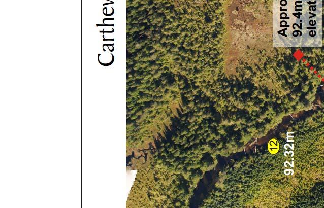
26 Tributary Access and Potential Stranding Monitoring Falls River WUP August Carthew Creek Carthew Creek enters Falls River at an elevation of approximately 90.7 m ASL. Therefore it is only nominally affected by reservoir elevations lower than this (reservoir elevations of 90.7 m would cause minor backwatering in Carthew Creek). Assessment by boat, foot, air and low level aerial photos determined that no geomorphic channel conditions exist that could result in a migration barrier in Carthew Creek from its confluence with Falls River, and the upper limit of the drawdown zone at 92.4 m ASL. Substrates in Carthew Creek are primarily fines and organic debris for the initial 1500 m, and transition to gravels as the stream attains a slight gradient. Figures 12, 13 and 14 document the channel conditions within the drawdown zone. Prepared by Cambria Gordon and Metlakatla Fisheries 18


27


28


29
30 Tributary Access and Potential Stranding Monitoring Falls River WUP August Hayward Creek Hayward Creek enters the reservoir in a confined low gradient channel (Figures 15 to 18). No significant barriers appear to be present in the stream channel above the reservoir elevation of 90.7 m ASL on the photos (Figures 15 to 18). The channel is extensively littered with LWD, and debris jams and beaver dams may present obstructions to fish passage under natural conditions. Below 90.7 m ASL, and downstream to the reservoir, the stream channel on the photos is backwatered by the reservoir, and the channel bottom is not visible. It is unlikely that a significant barrier to fish migration is present in this stream section as the stream channel has extensive streamside vegetation, thus indicating organic substrates (consistent with upstream sections). Should the reservoir be drawn down to 88.4 m ASL, minor obstructions due to LWD and organic deposits may be present, but are unlikely to present a barrier to cutthroat trout or Dolly Varden. Prepared by Cambria Gordon and Metlakatla Fisheries 22


31


32
33


34
 in the reservoir based on bathymetric data (Larratt, 1983) and site survey data collected as part of this project.")

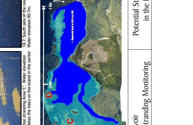
35 Tributary Access and Potential Stranding Monitoring Falls River WUP August Shoreline Stranding Survey Study Area Figure 8 estimates the drawdown zone (92.4 m to 88.4 m ASL) in the reservoir based on bathymetric data (Larratt, 1983) and site survey data collected as part of this project. Boundaries are not precise, and would be affected by local inflows and backwatering in tributaries. Of note, and particular concern for stranding is the extent of flooding at the furthest east end of the reservoir. Stranding risks associated with this and other areas are discussed below Potential Stranding Locations Within the Falls River reservoir drawdown zone, areas exist that would become dewatered during a reservoir drawdown. Figure 8 shows the drawdown zone of the reservoir and level of the water surface elevation in representative areas when the reservoir reaches 92.4 m ASL (under proposed WUP operations). Potential stranding areas are gently sloping vegetated areas, primarily located at the eastern end of the reservoir. These areas present a high stranding risk as they appear to provide good quality fish habitat (flooding vegetation and abundant LWD Figure 19), and during a reservoir drawdown, could become dewatered relatively quickly. Mudflat areas, while posing a stranding risk, are not deemed to be areas in which fish would utilize as habitat, and therefore are viewed to be lower risk stranding areas (Figure 19). Figure 19: Photo on left shows potential stranding area at the eastern end of the reservoir. Photo on right shows mud flat areas that are low value fish habitat. Comprehensive mapping of potential stranding areas was not within the scope of this project; however we have identified 5 representative areas where the risk of stranding is potentially high. Figure 20 shows the potential stranding areas along the reservoir margin, identified as A, B, C and D. Figure 21 shows potential stranding areas along Carthew Creek. Areas A (Figures 20.1 to 20.4), B (Figure 20.5) and C (Figure 20.6) at the eastern edge of the reservoir appear to present the highest risk of stranding. At the eastern margins of Sites A and B, areas exist that have minimal to low, water connection channels back to Prepared by Cambria Gordon and Metlakatla Fisheries 27
36 Tributary Access and Potential Stranding Monitoring Falls River WUP August 2010 the reservoir. Closer to the reservoir, these channels are more abundant, and appear to maintain connectivity at observed water elevations of 88.9 m ASL, and would likely still have connectivity at 88.4 m ASL. These channels are likely to mitigate stranding as fish may seek out deeper water areas as the reservoir level declines. This is likely during a gradual drawdown, as gradual dewatering of shoreline habitats is a natural occurrence in lake environments. However, a rapid drawdown would increase the risk of stranding, especially in the margin areas that are poorly connected to the reservoir. Area D along the south margin of the reservoir also presents a risk of stranding (Figure 20.7). This area also has broadly sloping vegetated areas where fish use can be expected, and that would dewater during a drawdown. Risk to stranding may be lower here than other areas, as connectivity to the reservoir is relatively close. Substantial areas along Carthew Creek present stranding hazards, including a large wetland complex (area marked as E on Figure 20). Based on our differential levelling survey, all of the margin areas along Carthew Creek are within the drawdown zone, as well as the complex wetland adjacent to the left bank (Figure 21). This wetland retains a substantial wetted area at low water within which fish could find refuge, however substantial areas exist around the margins that would dewater and potentially strand fish. Potential stranding in Hayward Creek is not expected, due to the steeper side slopes and relative confinement of the system (Figures 15 to 18). Figure 18 shows the estimated 92.4 m ASL drawdown zone marked on Hayward Creek. Prepared by Cambria Gordon and Metlakatla Fisheries 28


37


38
39 Tributary Access and Potential Stranding Monitoring Falls River WUP August Summary This project addressed the key management questions: 1 Are there migration barriers in tributaries within the potential drawdown zone of Big Falls Reservoir? 2 Are there locations where fish could be stranded along the Big Falls Reservoir shoreline? 4.1 Tributary Access No barriers to migration exist in the drawdown zone associated with Falls River or Carthew Creek. Neither creek has any geomorphic features that could create a barrier to fish migration at any flow or reservoir level. Hayward Creek does not appear to have a fish barrier within the drawdown zone; however site access considerations prevented groundtruthing of this assessment, which is based from high quality, low-level aerial photographs. This conclusion regarding barriers is substantiated by low level over-flights of these areas when the reservoir was <89 m ASL. 4.2 Fish Stranding in Big Falls Reservoir Potential stranding areas exist within the drawdown zone of the reservoir under WUP operations. These consist of large, gradually sloping vegetated areas that provide good quality fish habitat (flooding vegetation and abundant LWD), located primarily along the eastern end of the reservoir. Mudflat areas, also posing a stranding risk, are not deemed to be areas in which fish would utilize as habitat, and therefore are viewed to be lower risk stranding areas. Other potential stranding areas also exist along Carthew Creek and the south shore of the reservoir. Should the proposed WUP operating regime be implemented (specifically, installation of flashboards and temporary flooding to 92.4 m ASL), further assessment of stranding risk should occur. This assessment should consider: Operating regime and range and rate of potential drawdowns (i.e., when flashboards are removed in May, how far and how quickly will the drawdown occur, and how can this be controlled?) and Monitoring stranding during flashboard removal and adjusting drawdown rates as necessary. Prepared by Cambria Gordon and Metlakatla Fisheries 31
40 Tributary Access and Potential Stranding Monitoring Falls River WUP August References BC Hydro Consultative Committee Report: Falls River Water Use Plan. Prepared by the Falls River Water Use Plan Consultative Committee CGL and Metlakatla Fisheries, Big Falls Reservoir Wildlife Shoreline Habitat Monitoring (Year 3). Falls River Project Water Use Plan. CGL and Metlakatla Fisheries, Sedge Habitat Monitoring (Year 1). Falls River Project Water Use Plan. Forest Practices Code of British Columbia Fish-Stream Identification Guidebook. Second Edition, Version 2.1. Canadian Cataloguing in Publication Data. H. M. Larratt Aquatic Consulting Ltd Impact of Wood Debris and Standing Trees on the Productivity of Falls River Reservoir. BC Hydro Library. Parker, M.A., Fish Passage Culvert Inspection Completion Procedures. Watershed Restoration Program Technical Circular No. 11. RISC Manual of British Columbia Hydrometric Standards (Version 1.0). Prepared by the Ministry of Environment Science and Information Branch for the Resources Information Standards Committee. Whyte, I.W., Babakaiff, S., Adams, M.A. and Giroux, P.A Restoring fish access and rehabilitation of spawning sites. In: Fish habitat rehabilitation procedures. P. A. Slaney and D. Zaldokas. B.C. Ministry of Environment, Lands and Parks, Watershed Restoration Program. Watershed Restoration Technical Circular No. 9. Prepared by Cambria Gordon and Metlakatla Fisheries 32
Rebman Creek Evaluation of In-Stream Rehabilitation Structures
 Rebman Creek Evaluation of In-Stream Rehabilitation Structures Draft Report Prepared for: Weldwood of Canada Ltd. Quesnel, BC by: G3 Consulting Ltd. 4508 Beedie Street Burnaby, BC V5J 5L2 December 2000
RE: Engineered Riffle Concepts for Sodom Dam Removal Grade Control Elements
 November 19, 2009 Ms. Melissa Jundt NOAA Fisheries Hydropower Division 1201 NE Lloyd Boulevard, Suite 1100 Portland, Oregon 97232 RE: Engineered Riffle Concepts for Sodom Dam Removal Grade Control Elements
Supporting Guidance Note
 Supporting Guidance Note Supporting Guidance Note: SGN 2 Geomorphology photosurveys for hydropower developments We require a geomorphology photosurvey to be submitted with applications for abstraction
OVERVIEW INTRODUCTION TO SHOREBIRDS MANAGEMENT FOR SHOREBIRDS TVA REGIONAL SHOREBIRD PROJECT ESTIMATING SHOREBIRD NUMBERS
 SHOREBIRD CONSERVATION AND MONITORING RESOURCES US SHOREBIRD CONSERVATOIN PLAN http://www.fws.gov/shorebirdplan WATERFOWL MANAGEMENT HANDBOOK - http://www.nwrc.usgs.gov/wdb/pub/wmh/contents.html MANOMET
Peace Project Water Use Plan. Physical Works Terms of Reference. GMSWORKS-26 Communications and Safety Improvements Williston, Dinosaur and Peace
 Peace Project Water Use Plan Physical Works Terms of Reference GMSWORKS-26 Communications and Safety Improvements Williston, Dinosaur and Peace April 21, 2008 Peace Water Use Plan Physical Works Terms
ATTACHMENT H TACOMA HYDROELECTRIC PROJECT DESCRIPTION OF PROJECT FEATURES
 ATTACHMENT H TACOMA HYDROELECTRIC PROJECT DESCRIPTION OF PROJECT FEATURES The Tacoma Hydroelectric Project is located about 20 miles north of Durango, Colorado, on a high intermountain plateau west of
Wood Stork Aerial Survey Trip Report. Lake Murray and Saluda River August 27, Aircraft: Fixed-Wing Cessna 210 Survey Duration: hrs
 Survey Attendees Shane Boring Tom Murphy Bucky Harris Kleinschmidt SCDNR Endangered Species Biologist SCDNR Pilot Aircraft: Fixed-Wing Cessna 210 Survey Duration: 1300 1415 hrs Survey Observations The
Peace Project Water Use Plan. Williston Air Photos and DEM. Reference: GMSWORKS #14. Williston Air Photos and DEM 2011
 Peace Project Water Use Plan Williston Air Photos and DEM Reference: GMSWORKS #14 Williston Air Photos and DEM 2011 Study Period: May 2011 to December 2011 Les Giles Transmission Engineering, Photogrammetry
SOUTH CAROLINA ELECTRIC & GAS COMPANY COLUMBIA, SOUTH CAROLINA
 SOUTH CAROLINA ELECTRIC & GAS COMPANY COLUMBIA, SOUTH CAROLINA LAKE MURRAY WOOD STORK SURVEYS 2005 SUMMARY REPORT DECEMBER 2005 Prepared by: Kleinschmidt Associates Energy & Water Resource Consultants
Compensatory Mitigation Monitoring Report Aquatic Habitat Improvement City of Montrose Whitewater Park, Montrose County, Colorado March 6, 2014
 Compensatory Mitigation Monitoring Report Aquatic Habitat Improvement City of Montrose Whitewater Park, Montrose County, Colorado March 6, 2014 i. Project Overview 1. USACE # # SPK 2013 00851 2. Permittee:
Whakapapa River: 2014 Drift Dive Survey. Author: Adam Daniel Publication date: June 6, 2014 Auckland/Waikato Fish and Game Hamilton New Zealand
 Whakapapa River: 2014 Drift Dive Survey Author: Adam Daniel Publication date: June 6, 2014 Auckland/Waikato Fish and Game Hamilton New Zealand 1 SUMMARY Two drift dive surveys were carried out in the headwaters
Technical Memorandum ECO-7
 To: Woody Frossard, TRWD From: Bob Brashear, CDM This document is released for the purpose of interim review under the authority of Robert Brashear, P.E., TX license 80771 on 21-Mar-2005. It is not to
McKay Creek National Wildlife Refuge BCS number: 48-19
 Oregon Coordinated Aquatic Bird Monitoring: Description of Important Aquatic Bird Site McKay Creek National Wildlife Refuge BCS number: 48-19 Site description author(s) Howard Browers, Supervisory Wildlife
SWAN LAKE INTEGRATED WATERSHED MANAGEMENT PLAN SURFACE WATER HYDROLOGY REPORT 1
 SWAN LAKE INTEGRATED WATERSHED MANAGEMENT PLAN SURFACE WATER HYDROLOGY REPORT 1 1. General Description Figure 1 provides a map of the Swan Lake Watershed. The watershed is characterized by two major parallel
ENSURING LONGITUDINAL CONNECTIVITY OF THE JIU RIVER NEAR ISALNITA DAM
 Water resources and wetlands, Editors: Petre Gâştescu, William Lewis Jr., Petre Breţcan Conference Proceedings, 14-16 September 2012, Tulcea - Romania ISBN: 978-606-605-038-8 ENSURING LONGITUDINAL CONNECTIVITY
COPYRIGHTED MATERIAL. Contours and Form DEFINITION
 1 DEFINITION A clear understanding of what a contour represents is fundamental to the grading process. Technically defined, a contour is an imaginary line that connects all points of equal elevation above
Fall 2001 Whooping Crane Migrational Survey Protocol Implementation Report
 Fall 2001 Whooping Crane Migrational Survey Protocol Implementation Report Prepared by Executive Director s Office For Committee s of the Platte River Cooperative Agreement June 5, 2002 I. Introduction
Harlequin Ducks in Idaho Ecology, Distribution, Monitoring & Conservation
 Paul Higgins Harlequin Ducks in Idaho Ecology, Distribution, Monitoring & Conservation Sonya Knetter & Frances Cassirer, IDFG Jacob Briggs, BYU-Idaho Idaho Bird Conservation Partnership, March 12, 2015
The Basics. HECRAS Basis Input. Geometry Data - the basics. Geometry Data. Flow Data. Perform Hydraulic Computations. Viewing the Output
 The Basics HECRAS Basis Input Geometry Data. Flow Data. Perform Hydraulic Computations by G. Parodi WRS ITC The Netherlands Viewing the Output ITC Faculty of Geo-Information Science and Earth Observation
Memorandum. Application for Amendment to DNR Land Use Permit # LAS29209
 Memorandum Date: September 12, 2013 Project Number: 1992.06k To: From: Subject: cc: Jessica Meybin (ADNR) Tim Sullivan (R2) Application for Amendment to DNR Land Use Permit # LAS29209 Kevin Petrone and
XAYABURI HYDROELECTRIC POWER PROJECT. Fish Migration Facilities Vientiane, 15 July 2015 Dr Tobias Coe
 XAYABURI HYDROELECTRIC POWER PROJECT Fish Migration Facilities Vientiane, 15 July 2015 Dr Tobias Coe CHAPTER SLIDE, IMAGE ARIAL BOLD 30 PT, CAPITALS CONTENT OF PRESENTATION General issues at Xayaburi Data
Sauvie Island Wildlife Area BCS number: 47-28
 Sauvie Island Wildlife Area BCS number: 47-28 Site description author(s) Mark Nebeker, Oregon Department of Fish and Wildlife, Sauvie Island Wildlife Area Manager Primary contact for this site Mark Nebeker,
Tiered Species Habitats (Terrestrial and Aquatic)
") Tiered Species Habitats (Terrestrial and Aquatic) Dataset Description Free-Bridge Area Map The Department of Game and Inland Fisheries (DGIF s) Tiered Species Habitat data shows the number of Tier 1, 2
Tiered Species Habitats (Terrestrial and Aquatic) Dataset Description Free-Bridge Area Map The Department of Game and Inland Fisheries (DGIF s) Tiered Species Habitat data shows the number of Tier 1, 2
SOUTH CAROLINA ELECTRIC & GAS COMPANY COLUMBIA, SOUTH CAROLINA
 SOUTH CAROLINA ELECTRIC & GAS COMPANY COLUMBIA, SOUTH CAROLINA LAKE MURRAY WOOD STORK SURVEYS 2006 SUMMARY REPORT MARCH 2007 Prepared by: Kleinschmidt Associates Energy & Water Resource Consultants 101
San Juan River Watershed: Fish Passage Assessments
 San Juan River Watershed: Fish Passage Assessments Table of Contents 1.0 INTRODUCTION...6 1.1 BACKGROUND... 6 1.2 STUDY AREA... 7 1.3 SCOPE... 7 1.4 ASSUMPTIONS... 7 1.5 LIMITATIONS... 8 1.6 PROJECT SCHEDULE...
Appendix A Little Brown Myotis Species Account
 Appendix 5.4.14A Little Brown Myotis Species Account Section 5 Project Name: Scientific Name: Species Code: Status: Blackwater Myotis lucifugus M_MYLU Yellow-listed species by the British Columbia Conservation
MONTHLY UPDATE REPORT - PRIMROSE SOUTH W4M OCTOBER 7, 2013
 MONTHLY UPDATE REPORT - PRIMROSE SOUTH 09-21-067-04 W4M OCTOBER 7, Introduction The Primrose South in situ oil sands project is located in the Cold Lake Air Weapons Range approximately 65 km north-northeast
Ladd Marsh Wildlife Area BCS number: 49-3
 Oregon Coordinated Aquatic Bird Monitoring: Description of Important Aquatic Bird Site Ladd Marsh Wildlife Area BCS number: 49-3 Site description author M. Cathy Nowak, Ladd Marsh Wildlife Area Biologist
LOON FLOATING NEST PLATFORMS 2014 ANNUAL REPORT
 SETTLEMENT AGREEMENT ARTICLE 507 LOON FLOATING NEST PLATFORMS 2014 ANNUAL REPORT REPORTING PERIOD JANUARY 1 DECEMBER 31, 2014 BAKER RIVER HYDROELECTRIC PROJECT FERC No. 2150 September 2015 PUGET SOUND
Cat Island Chain Restoration Project Brown County Port & Resource Recovery Department
 Cat Island Chain Restoration Project Brown County Port & Resource Recovery Department February 2, 2015 Fox River and Lower Green Bay Cat Island Chain - 1938 Cat Island Brown County Aerial Photography,
Roberts Bank Terminal 2 Project Field Studies Information Sheet
 July 2012 Port Metro Vancouver is continuing field studies in July as part of ongoing environmental and technical work for the proposed Roberts Bank Terminal 2 Project. Roberts Bank Terminal 2 Project
Roberts Bank Terminal 2 Project Field Studies Information Sheet
 January 2013 Port Metro Vancouver is continuing field studies in January as part of ongoing environmental and technical work for the proposed. The is a proposed new multi berth container terminal which
Assessment of White-bellied Heron (Ardea insignis) population and its distribution in Kurichhu and Drangmachhu basins, Eastern Bhutan
 population and its distribution in Kurichhu and Drangmachhu basins, Eastern Bhutan") Assessment of White-bellied Heron (Ardea insignis) population and its distribution in Kurichhu and Drangmachhu basins, Eastern Bhutan Jigme Dorji June 2018 Introduction White-bellied heron is the most
Assessment of White-bellied Heron (Ardea insignis) population and its distribution in Kurichhu and Drangmachhu basins, Eastern Bhutan Jigme Dorji June 2018 Introduction White-bellied heron is the most
Division: Habitat and Species Conservation Authors: Claire Sunquist Blunden and Brad Gruver
 Division: Habitat and Species Conservation Authors: Claire Sunquist Blunden and Brad Gruver Report date: December 13, 2018 All photos by FWC unless otherwise acknowledged Presenting 6 new guidelines 1
Brief report to Ramsar Convention Secretariat. Azerbaijan Republic
 Brief report to Ramsar Convention Secretariat Azerbaijan Republic Various wetlands are to be met in the territory of Azerbaijan. They support existence of large population of waterfowl as well as highproductivity
Jackson Bottom Wetlands Preserve BCS Number: 47-14
 Jackson Bottom Wetlands Preserve BCS Number: 47-14 Site description author(s) Greg Gillson, Jackson Bottom Wetlands Preserve Primary contact for this site Ed Becker, Natural Resources Manager, Jackson
Results of Nesting Bird Survey in Support of Fiscalini Ranch Forest Test Plots, Cambria, California
 May 26, 2016 Carlos Mendoza Cambria Community Services District 1316 Tamsen Drive, Suite 201 Cambria, California 93428 RE: Results of Nesting Bird Survey in Support of Fiscalini Ranch Forest Test Plots,
ODFW Life Cycle Monitoring Project
 ODFW Life Cycle Monitoring Project Background and Potential as Intensively Monitored Watersheds Erik Suring . Necanicum Lower Nehalem Upper Nehalem Nehalem Scappoose River Scappoose LCM Background Cummins
Smith and Bybee Wetlands Natural Area BCS number 47-33
 Smith and Bybee Wetlands Natural Area BCS number 47-33 Site description author(s) Elaine Stewart, Smith and Bybee Lakes Wildlife Area Manager Danielle Morris, Research and Monitoring Team, Klamath Bird
Soft Engineering Case Study: Wallasea Island
 Soft Engineering Case Study: Wallasea Island Situation By the British Geographer Wallasea Island is on the south side of the Crouch Estuary in Essex and also linked to the Roach Estuary. These estuaries
1. Qualitative Assessment... II-101
 Table of Contents I. Introduction... I-1 A. Session Law 2009-479 / House Bill 709... I-2 B. Public Consultation... I-3 C. Selection of Study Sites... I-5 D. Limitations of Study... I-8 II. Physical Assessment...
Susitna-Watana Hydroelectric Project (FERC No ) Waterbird Migration, Breeding, and Habitat Use Study Plan Section 10.15
 Waterbird Migration, Breeding, and Habitat Use Study Plan Section 10.15") (FERC No. 14241) Waterbird Migration, Breeding, and Habitat Use Study Plan Section 10.15 Initial Study Report Part C: Executive Summary and Section 7 Prepared for Prepared by ABR, Inc. Environmental Research
(FERC No. 14241) Waterbird Migration, Breeding, and Habitat Use Study Plan Section 10.15 Initial Study Report Part C: Executive Summary and Section 7 Prepared for Prepared by ABR, Inc. Environmental Research
Warner Wetlands / Warner Valley BCS number: 48-31
 Oregon Coordinated Aquatic Bird Monitoring: Description of Important Aquatic Bird Site Warner Wetlands / Warner Valley BCS number: 48-31 Site description author(s) Vernon Stofleth, Lakeview BLM District
LOWER YUBA RIVER ACCORD MONITORING
 LOWER YUBA RIVER ACCORD MONITORING AND EVALUATION PROGRAM AERIAL MAPPING OF STREAMWOOD AND HUMAN- BUILT DETRITUS AVAILABLE AS COVER IN THE LOWER YUBA RIVER IN AUTUMN 2008 MAY 9, 2014 (Aerial photo of a
Discovery Report Appendix L Dams and Floodplain Structures Lake Ontario St. Lawrence Watershed HUC
 Discovery Report Appendix L Dams and Floodplain Structures Lake Ontario St. Lawrence Watershed HUC 04150309 July 2016 Federal Emergency Management Agency Department of Homeland Security 26 Federal Plaza
Basic Surveying. Kabul, Afghanistan February 2011
 Basic Surveying Kabul, Afghanistan February 2011 1 This watershed rehabilitation and restoration training was prepared by the U.S. Department of Agriculture (USDA) team of Jon Fripp (Civil Engineer USDA/NRCS),
South Canoe Wind Power Project Appendix C: Wetland Assessment Report
 South Canoe Wind Power Project 2012 Appendix C: Wetland Assessment Report WETLAND ASSESSMENT SOUTH CANOE WIND PROJECT Revised: February 17, 2012 February 17, 2012 Mr. Chris Peters Minas Basin Pulp and
Feldale Internal Drainage Board Biodiversity Action Plan Report Drainage Ditch Action Plan
 Feldale Internal Drainage Board Biodiversity Plan Report 04-5 Drainage Ditch Plan IDB s Partners Date Indicators Report 4 Manage ditches for biodiversity as well as for drainage Identify ditches of conservation
Lake St. Clair Coastal Wetlands in 2050: Modelling Wetland Community Responses to Climate Change Water Level Scenarios
 Lake St. Clair Coastal Wetlands in 2050: Modelling Wetland Community Responses to Climate Change Water Level Scenarios Joel W. Ingram 1, Linda D. Mortsch 2, Susan E. Doka 3, Andrea J. Hebb 2, Shawn W.
State of New Jersey Chris Christie, Governor. Dept. of Environmental Protection Bob Martin, Commissioner
 Cape May Beach 2016/2017 Renourishment Cape May Inlet to Lower Township & Lower Cape May Meadows Cape May Point Cape May County, New Jersey New Jersey Department of Environmental Protection Engineering
UPPER MISSISSIPPI RIVER RESTORATION LAKE ODESSA HABITAT REHABILITATION AND ENHANCEMENT PROJECT OPERATION AND MAINTENANCE MANUAL APPENDIX F
 UPPER MISSISSIPPI RIVER RESTORATION LAKE ODESSA HABITAT REHABILITATION AND ENHANCEMENT PROJECT OPERATION AND MAINTENANCE MANUAL APPENDIX F PROJECT PHOTOGRAPHS Table of Photographs Photograph 1: Lake Odessa
Pilot Project Ross Valley Watershed Geomorphology GIS Database Final Report August 30, 2010
 Pilot Project Ross Valley Watershed Geomorphology GIS Database Final Report August 30, 2010 Prepared by: Gerhard Epke 2010 Watershed Intern (831) 332-1324 24 Bolinas Ave San Anselmo, CA 94960 Supervised
Loy Gulch, Paint Pony, East Fork Paint Pony LOMR
 Loy Gulch, Paint Pony, East Fork Paint Pony LOMR Woodland Park, CO Prepared by: Michael Baker International 165 S. Union Blvd, Suite 200 Lakewood, CO 80226 TABLE OF CONTENTS I. INTRODUCTION... 2 1.1 Purpose...
AERIAL SURVEY OF BIRDS AT MONO LAKE ON AUGUST 24, 1973
 AERIAL SURVEY OF BIRDS AT MONO LAKE ON AUGUST 24, 1973 by Ronald M. Jurek Special Wildlife Investigations Wildlife Management Branch California Department of Fish and Game September 1973 Jurek, R.M. 1973.
Table of Contents. Chapter 1.0 Purpose and Need
 Table of Contents Chapter 1.0 Purpose and Need CHAPTER 1.0 PURPOSE AND NEED... 1 1.1 INTRODUCTION... 1 1.1.1 EA ORGANIZATION... 1 1.2 PROJECT AREA... 1 1.3 PROPOSED ACTION... 2 1.3.1 SCOPE OF THE PROPOSED
APPENDIX E - FLOODPLAIN INFORMATION
 CITY OF WOODLAND PARK STORMWATER MASTER PLAN - Floodplain Information APPENDIX E - FLOODPLAIN INFORMATION E1 - Floodplain Information TABLE OF CONTENTS I. INTRODUCTION... 2 Loy Gulch, Paint Pony, East
2011 Mountain Yellow-legged Frog Monitoring Plan Survey Results El Dorado Hydroelectric Project, FERC No. 184
 2011 Mountain Yellow-legged Frog Monitoring Plan Survey Results El Dorado Hydroelectric Project, FERC No. 184 February 2012 Prepared For: El Dorado Irrigation District 2890 Mosquito Road Placerville, California
Black-crowned Night-heron Minnesota Conservation Summary
 Credit Deborah Reynolds Black-crowned Night-heron Minnesota Conservation Summary Audubon Minnesota Spring 2014 The Blueprint for Minnesota Bird Conservation is a project of Audubon Minnesota written by
THE MERSEY GATEWAY PROJECT (MERSEY GATEWAY BRIDGE) AVIAN ECOLOGY SUMMARY PROOF OF EVIDENCE OF. Paul Oldfield
 AVIAN ECOLOGY SUMMARY PROOF OF EVIDENCE OF. Paul Oldfield") HBC/14/3S THE MERSEY GATEWAY PROJECT (MERSEY GATEWAY BRIDGE) AVIAN ECOLOGY SUMMARY PROOF OF EVIDENCE OF Paul Oldfield 1 1 DESCRIPTION OF THE BIRDLIFE IN THE UPPER MERSEY ESTUARY LOCAL WILDLIFE SITE 1.1
HBC/14/3S THE MERSEY GATEWAY PROJECT (MERSEY GATEWAY BRIDGE) AVIAN ECOLOGY SUMMARY PROOF OF EVIDENCE OF Paul Oldfield 1 1 DESCRIPTION OF THE BIRDLIFE IN THE UPPER MERSEY ESTUARY LOCAL WILDLIFE SITE 1.1
BALD EAGLE MANAGEMENT 2014 ANNUAL REPORT
 SETTLEMENT AGREEMENT ARTICLE 513 BALD EAGLE MANAGEMENT 2014 ANNUAL REPORT REPORTING PERIOD JANUARY 1 DECEMBER 31, 2014 BAKER RIVER HYDROELECTRIC PROJECT FERC No. 2150 September 2015 PUGET SOUND ENERGY
AutoCAD 2016 for Civil Engineering Applications
 Introduction to AutoCAD 2016 for Civil Engineering Applications Learning to use AutoCAD for Civil Engineering Projects Nighat Yasmin Ph.D. SDC P U B L I C AT I O N S Better Textbooks. Lower Prices. www.sdcpublications.com
Evaluation of an Electrical Gradient as a Seal Deterrent Puntledge River Study, April 10 24, 2007 Preliminary Results
 Evaluation of an Electrical Gradient as a Seal Deterrent Puntledge River Study, April 10 24, 2007 Preliminary Results From April 10 25, 2007, staff from the Pacific Salmon Commission (PSC), Department
SPECIAL PUBLIC NOTICE
 SPECIAL PUBLIC NOTICE Draft Map and Drawing Standards for the South Pacific Division Regulatory Program August 6, 2012 Corps contacts: Sacramento District: Michael Finan (916) 557-5324 (Michael.C.Finan@usace.army.mil)
Relicensing Study 3.5.1
 Relicensing Study 3.5.1 BASELINE INVENTORY OF WETLAND, RIPARIAN AND LITTORAL HABITAT IN THE TURNERS FALLS IMPOUNDMENT, AND ASSESSMENT OF OPERATIONAL IMPACTS ON SPECIAL-STATUS SPECIES Updated Study Report
Smith River Mouth BCS number: 86-6
 Smith River Mouth BCS number: 86-6 ***NOTE: We were unable to determine all necessary information for this site description. If you would like to contribute the needed information to this description,
Mystic Lake Hydroelectric Project FERC Project Number Year Bald Eagle Monitoring Summary Report Public
 Mystic Hydroelectric Project FERC Project Number 2301 3-Year Bald Eagle Monitoring Summary Report 2010-2013 Public 2013 by PPL Montana, LLC. ALL RIGHTS RESERVED Submitted to: Federal Energy Regulatory
McNabney Marsh Nesting Bird Surveys
 McNabney Marsh 2014 Nesting Bird Surveys Prepared for: Mt View Sanitary District PO Box 2757 Martinez, CA 94553 Contact: Kelly Davidson 925.228.5635 Prepared by: PO Box 188888 Sacramento, CA 95818 Contact:
Youngs Creek Hydroelectric Project FERC No
 Youngs Creek Hydroelectric Project FERC No. 10359 WILDLIFE HABITAT MITIGATION PLAN License Article 403 2015 ANNUAL REPORT Prepared By: Everett, WA January 2016 Final This document has been prepared for
Big Falls Reservoir Wildlife Shoreline Habitat Monitoring Plan (Year 1)
") Falls River Project Water Use Plan Big Falls Reservoir Wildlife Shoreline Habitat Monitoring Plan (Year 1) Reference: Falls MON#6 Falls River Water Use Plan Monitoring Program: Big Falls Reservoir Wildlife
Falls River Project Water Use Plan Big Falls Reservoir Wildlife Shoreline Habitat Monitoring Plan (Year 1) Reference: Falls MON#6 Falls River Water Use Plan Monitoring Program: Big Falls Reservoir Wildlife
ASSESSING HABITAT QUALITY FOR PRIORITY WILDLIFE SPECIES IN COLORADO WETLANDS
 C O L O R A D O P A R K S Dabbling Ducks & W I L D L I F E GADWALL TOM KOERNER, USFWS / AMERICAN WIGEON BILL GRACEY NORTHERN PINTAIL GEORGIA HART / MALLARD MICHAEL MENEFEE, CNHP / ALL TEAL PHOTOS TOM KOERNER,
In response to a request from Water Rights Branch, a short. In general, the sequence of post glacial events in the immediate. D. M.
 . TO Dr. J. C. Foweraker......!...... C&* Groundwater Div i s ion... GOVERNMENT OF BRITISH COLUMBIA M EM0 RAN DU M D. M. Callan Groundwater Division... July 6th... 19... 71... SUBJECT GROUNDWATER INVESTIGATION
Section 1. Introduction
 Overview of Manual Acknowledgements i x Section 1. Introduction 1.0 Overview of Section 1 1-1 1.1 The GESC and DESC Permits 1-2 1.2 Reasons for the GESC and DESC Permits 1-2 1.3 Legislative Mandate 1-3
Bald Eagle Annual Report February 1, 2016
 Bald Eagle Annual Report 2015 February 1, 2016 This page intentionally blank. PROJECT SUMMARY Project Title: Bald Eagle HCP Monitoring Subject Area: Habitat Conservation Plan (HCP) monitoring Date initiated:
Site Plan Review Application. Interest in the Property (e.g. fee simple, land option, etc.)
") 1. Identification CITY OF FENTON 301 South Leroy Street Fenton, Michigan 48430-2196 (810) 629-2261 FAX (810) 629-2004 Site Plan Review Application Project Name Applicant Name Address City/State/Zip Phone
1. Identification CITY OF FENTON 301 South Leroy Street Fenton, Michigan 48430-2196 (810) 629-2261 FAX (810) 629-2004 Site Plan Review Application Project Name Applicant Name Address City/State/Zip Phone
BALD EAGLE NIGHT ROOST SURVEYS
 SETTLEMENT AGREEMENT ARTICLE 512 BALD EAGLE NIGHT ROOST SURVEYS SEASON ONE RESULTS: NOVEMBER 2009 FEBRUARY 2010 BAKER RIVER HYDROELECTRIC PROJECT FERC No. 2150 Puget Sound Energy Bellevue, Washington May
Upper Klamath National Wildlife Refuge Complex Upper Klamath Unit and Hank s Marsh Unit BCS Number: 48-29
 Oregon Coordinated Aquatic Bird Monitoring: Description of Important Aquatic Bird Site Upper Klamath National Wildlife Refuge Complex Upper Klamath Unit and Hank s Marsh Unit BCS Number: 48-29 Site description
ANNEX Following the discussions at the National Environmental Protection Agency in Bucharest on to clarify some aspects regarding the
 ANNEX Following the discussions at the National Environmental Protection Agency in Bucharest on 08.25.2014 to clarify some aspects regarding the Appropriate Assessment Study of the above-mentioned project
SPECIAL PUBLIC NOTICE
 SPECIAL PUBLIC NOTICE Draft Map and Drawing Standards for the South Pacific Division Regulatory Program March 5, 2012 Comment period: ends April 5, 2012 Corps contact: Thomas Cavanaugh (415) 503-6574 (Thomas.J.Cavanaugh@usace.army.mil)
Klamath Marsh National Wildlife Refuge BCS number: 48-16
 Oregon Coordinated Aquatic Bird Monitoring: Description of Important Aquatic Bird Site Klamath Marsh National Wildlife Refuge BCS number: 48-16 Site description author(s) Carol Damberg, Klamath Marsh NWR
ENVIRONMENTAL ASSESSMENT (EA) PROCESS
 PROCESS") ENVIRONMENTAL ASSESSMENT (EA) PROCESS THE PROJECT Emera Newfoundland & Labrador (ENL) is seeking environmental regulatory approvals to construct and operate the Maritime Link Transmission Project between
ENVIRONMENTAL ASSESSMENT (EA) PROCESS THE PROJECT Emera Newfoundland & Labrador (ENL) is seeking environmental regulatory approvals to construct and operate the Maritime Link Transmission Project between
Module 6 : Design of Retaining Structures. Lecture 30 : Dewatering [ Section 30.1 : Introduction ]
![Module 6 : Design of Retaining Structures. Lecture 30 : Dewatering [ Section 30.1 : Introduction ]](/thumbs/78/77377713.jpg "Module 6 : Design of Retaining Structures. Lecture 30 : Dewatering [ Section 30.1 : Introduction ]") Lecture 30 : Dewatering [ Section 30.1 : Introduction ] Objectives In this section you will learn the following Introduction Lecture 30 : Dewatering [ Section 30.1 : Introduction ] Introduction Dewatering
Lecture 30 : Dewatering [ Section 30.1 : Introduction ] Objectives In this section you will learn the following Introduction Lecture 30 : Dewatering [ Section 30.1 : Introduction ] Introduction Dewatering
B422 - PRECAST REINFORCED CONCRETE BOX CULVERTS AND BOX SEWERS - OPSS 422
 B422 - PRECAST REINFORCED CONCRETE BOX CULVERTS AND BOX SEWERS - OPSS 422 422.1 GENERAL The work under these tender items consists of the fabrication and installation in open cut of precast reinforced
Tahkenitch Creek Estuary BCS number: 47-35
 Tahkenitch Creek Estuary BCS number: 47-35 ***NOTE: We were unable to determine all necessary information for this site description. If you would like to contribute the needed information to this description,
Alvord Lake BCS number: 48-2
 Oregon Coordinated Aquatic Bird Monitoring: Description of Important Aquatic Bird Site Alvord Lake BCS number: 48-2 Site description author(s) Whitney Haskell, Data Management Intern, Klamath Bird Observatory
CONTOURS SURVEYING 1 CE 215 CHAPTER -3- Ishik University / Sulaimani Civil Engineering Department 12/7/2017. Ishik University / Sulaimani
 Civil Engineering Department SURVEYING 1 CE 215 CHAPTER -3- CONTOURS 1 2 1 3 4 2 PURPOSE OF CONTOURING Contour survey is carried out at the starting of any engineering project such as a road, a railway,
Map and Drawing Standards for the South Pacific Division Regulatory Program
 Map and Drawing Standards for the South Pacific Division Regulatory Program Hollis Jencks Project Manager, Nevada/Utah Section Sacramento District Regulatory Program Workshop 31 May 2018 US Army Corps
Introduction. Introduction Wetland Management -53% -60% Tennessee
 Waterbird and Food Resource Responses to Winter Drawdown in the east Tennessee River Valley John W. Laux M. S. Candidate University of Tennessee Knoxville Department of Forestry, Wildlife and Fisheries
SURVEY OF SEAGRASS BEDS AT PLACEMENT AREA 62, WEST BAY CONTRACT FOR GIWW, TEXAS CAUSEWAY U. S. ARMY CORPS OF ENGINEERS CONTRACT NO.
 SURVEY OF SEAGRASS BEDS AT PLACEMENT AREA 62, WEST BAY CONTRACT FOR GIWW, TEXAS CAUSEWAY U. S. ARMY CORPS OF ENGINEERS CONTRACT NO. W912HY-10-C-0036 Prepared for: RLB CONTRACTING, INC. P.O. Box 1739 Port
Oregon Dunes National Recreation Area BCS Number: 47-5
 Oregon Dunes National Recreation Area BCS Number: 47-5 ***NOTE: We were unable to determine all necessary information for this site description. If you would like to contribute the needed information to
Dependence of Predicted Dewatering on Size of Hydraulic Stress Used for Groundwater Model Calibration
 Proceedings of Mine Water Solutions 2018 June 12 15, 2018, Vancouver, Canada Published by the University of British Columbia, 2018 Dependence of Predicted Dewatering on Size of Hydraulic Stress Used for
Performance Monitoring
 Performance Monitoring Rock Island District Kara N. Mitvalsky, P.E. CEMVR-EC-DN Traditional Reports Analysis of existing data Comparison of data points to objectives identified in the feasibility reports
Floodplain Modeling 101. Presentation Goals
 Floodplain Modeling 101 Presenter: Joseph L. Miller, P.E., CFM 2016 INAFSM Conference Presentation Goals Introduction to Indiana s and FEMA s floodplain modeling technical requirements for riverine modeling
Aboriginal Consultation and Environmental Assessment Handout CEAA November 2014
 Introduction The Government of Canada consults with Aboriginal peoples for a variety of reasons, including: statutory and contractual obligations, policy and good governance, building effective relationships
THREATENED, ENDANGERED, AND SENSITIVE SPECIES 2011 ANNUAL REPORT
 LICENSE ARTICLE 410 THREATENED, ENDANGERED, AND SENSITIVE SPECIES 2011 ANNUAL REPORT REPORTING PERIOD JANUARY 1 DECEMBER 31, 2011 BAKER RIVER HYDROELECTRIC PROJECT FERC. 2150 April 2012 BAK LA 410 Annual
The Long Point Causeway: a history and future for reptiles. Scott Gillingwater
 The Long Point Causeway: a history and future for reptiles Scott Gillingwater Environmental Effects Long Point World Biosphere Reserve UNESCO designated the Long Point World Biosphere Reserve in April
Bald Eagle and Osprey Nest Survey Study Plan for Energy Northwest's Packwood Lake Hydroelectric Project FERC No Lewis County, Washington
 Revised Bald Eagle and Osprey Nest Survey Study Plan for Energy Northwest's Packwood Lake Hydroelectric Project FERC No. 2244 Lewis County, Washington Submitted to P.O. Box 968 Richland, Washington 99352-0968
Managing wetlands and rice to improve habitat for shorebirds and other waterbirds
 Managing wetlands and rice to improve habitat for shorebirds and other waterbirds Matthew E. Reiter Point Blue Conservation Science Wetland Management Workshop Sacramento National Wildlife Refuge May 9,
PHOTOGRAMMETRY STEREOSCOPY FLIGHT PLANNING PHOTOGRAMMETRIC DEFINITIONS GROUND CONTROL INTRODUCTION
 PHOTOGRAMMETRY STEREOSCOPY FLIGHT PLANNING PHOTOGRAMMETRIC DEFINITIONS GROUND CONTROL INTRODUCTION Before aerial photography and photogrammetry became a reliable mapping tool, planimetric and topographic
PART FIVE: Grassland and Field Habitat Management
 PART FIVE: Grassland and Field Habitat Management PAGE 64 15. GRASSLAND HABITAT MANAGEMENT Some of Vermont s most imperiled birds rely on the fields that many Vermonters manage as part of homes and farms.
FACULTY OF CIVIL ENGINEERING & EARTH RESOURCES ENGINEERING SURVEY FIELDWORK. LEVELING (Standard Of Procedure)
") FACULTY OF CIVIL ENGINEERING & EARTH RESOURCES ENGINEERING SURVEY FIELDWORK LEVELING (Standard Of Procedure) Subject Code Date Group Number Student Name & ID Number Group Member Name & ID Number 1 2 Lecturer
FACULTY OF CIVIL ENGINEERING & EARTH RESOURCES ENGINEERING SURVEY FIELDWORK LEVELING (Standard Of Procedure) Subject Code Date Group Number Student Name & ID Number Group Member Name & ID Number 1 2 Lecturer