Map and Drawing Standards for the South Pacific Division Regulatory Program
|
|
|
- Brandon Booker
- 5 years ago
- Views:
Transcription


1 Map and Drawing Standards for the South Pacific Division Regulatory Program Hollis Jencks Project Manager, Nevada/Utah Section Sacramento District Regulatory Program Workshop 31 May 2018 US Army Corps of Engineers

2

3 BUILDING STRONG
4 Applicability Standards apply to all submittals to Regulatory Divisions within the Districts of the Corps South Pacific Division Delineation maps Proposed projects (impact maps) Mitigation plan and long-term preservation maps As-built plans (post-construction drawings) Mitigation monitoring report maps
5 Applicability Standards can be modified or waived at Corps discretion Small or temporary impacts Applicant has limited financial resources Emergencies Restorations with limited funding Reauthorizations or maintenance, repair, rehabilitation, where original authorization included adequate drawings Compensatory Mitigation Plan drawings/maps Must adhere to the Standards even if Standards are waived for the overall project
6 Why are there standards for maps and drawings? Improve the quality and consistency Simplify the review process by project managers Good maps = clear story = faster review times and fewer requests for additional information
7 Map and Drawing Standards Organization General Standards section The broadest of the map and drawing requirements Specifies format and required elements for ALL maps submitted Additional sections focused on specific types of maps or plans e.g., for proposed projects, delineations, impacts maps, mitigation maps, etc Specify format and required elements for specific map types
8 Format of submittal Electronic versions are required General Standards PDF is the preferred electronic document format Electronic document requirement may be waived for applicants without software access Shapefiles GIS files submitted should be in the preferred format is ESRI shapefile. Metadata needs to include at a minimum, datum(s) used, coordinate system, projection, and cartographer contact information Please submit electronic files on CD/DVD, or via links to a secure FTP site. No flash drives!!
9 General Standards Submission of both a location (vicinity) map AND plan view map is a minimum requirement Location Maps At least one must use a USGS 7.5-minute quadrangle sheet as its basemap Quadrangle name identified Project study boundary clearly outlined and annotated Should include recognizable landmarks Include the names of adjacent local roadways North arrow
10 General Standards Submission of both a location (vicinity) map AND plan view map is a minimum requirement Plan View Maps At least two control points on opposite corners, with latitude and longitude clearly annotated Date prepared/revised Name and organization of the map preparer Bar scale and scale text North arrow
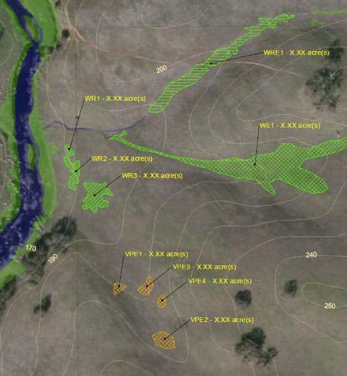
11 General Standards Submission of both a location (vicinity) map AND plan view map is a minimum requirement Plan View Maps Legend for all relevant features on the map this means wetlands and other waters of the U.S., the project boundary, project construction footprint, impacts to waters of the U.S., etc. Legend should include acres or square feet in parentheses for EVERY relevant feature or class of features! If elevations are shown, the vertical datum being used must be indicated on the map Locations of any cross-sectional views must be annotated clearly (e.g. A-A )
12 BUILDING STRONG
13 BUILDING STRONG
14 BUILDING STRONG

15 BUILDING STRONG
16 General Standards Basemaps used in Plan View Maps Topography is required, and should be shown on at least one map Aerial photography (if used) Date stamped Orthorectified Source identified Choose imagery with maximum visibility of aquatic resources (e.g. wet season)

17 BUILDING STRONG
18 Cross-Sectional Views Specific Standards Must have a bar scale and scale text, for both the horizontal and vertical dimensions Vertical datum must be indicated Cross-Sectional Views are required for: Identifying the location of OHWM for stream on delineation maps Proposed Projects / Construction Drawings Mitigation Plans / Long Term Preservation Maps As-Builts / Post-Construction Drawings
19 Proposed Projects Specific Standards All proposed impacts, structures, and limits of work within and adjacent to wetlands and potential waters of the U.S. must be shown Clearly annotate all impacts of work as either permanent or temporary
20 BUILDING STRONG
21 BUILDING STRONG
22 BUILDING STRONG

23 BUILDING STRONG


24 BUILDING STRONG

25 BUILDING STRONG
26 Specific Standards Post-Construction Drawings (As-Builts) Should be the same size and spatial alignment as the authorized plans Any deviations from fills and structures authorized as part of an approved pre-construction map must be indicated.
27 Delineation Maps Specific Standards Survey area boundary should be clearly symbolized, and should include all potential waters of the U.S. Location and extent of all areas meeting the three wetland criteria, and/or having an Ordinary High Water Mark, must be shown on the map, even if area is a potential Preamble Water (e.g., upland ditch) Each type of boundary (e.g., OHWM, type of wetland, high tide line) must be clearly symbolized and differentiated Each line or polygon representing a potential water of the U.S. must be labeled with a unique name and include the acreage or linear feet
28 Delineation Maps Specific Standards Show locations of all data points, labeled according to their corresponding data sheets A wetland boundary should be based on at least one set of paired data points; one data point within the proposed wetland boundary, and one immediately outside of it. Identify the Ordinary High Water Mark (OHWM) Show representative widths between the OHWMs on opposing banks using a transect line labeled with the width in feet An average width may be acceptable for uniform channel reaches
29 Specific Standards Mitigation Plans and Long-Term Preservation Maps Mitigation boundaries must be clearly differentiated based on mitigation type Establishment Re-establishment Rehabilitation Enhancement Preservation
30 Specific Standards Mitigation Plans and Long-Term Preservation Maps Standards require mitigation areas to be differentiated by using different hatched fill symbols, rather than by different border line types All mitigation sites and Long-Term Preservation boundaries must be clearly labeled with a unique name Locations of mitigation sites must be shown relative to other landscape features and habitat types (e.g., riparian corridor, wetland complex, etc.)

31 BUILDING STRONG
32 Specific Standards Mitigation Monitoring Report Maps Ground photographs included in reports must be accompanied by a map of photo points Each photo point must be annotated with a number and an arrow indicating the compass direction in which it was taken The photo itself should have a legend indicating photo number, the compass direction in which it was taken, the photo s geographic coordinates, and a brief explanation of the photo s relevance
33 Specific Standards Mitigation Monitoring Report Maps Each discrete mitigation site must be shown on the map Each site should be annotated or symbolized to indicate the mitigation type and the target habitat type Any sampling presented in the monitoring report should be shown on the map


34 BUILDING STRONG
SPECIAL PUBLIC NOTICE
 SPECIAL PUBLIC NOTICE Draft Map and Drawing Standards for the South Pacific Division Regulatory Program August 6, 2012 Corps contacts: Sacramento District: Michael Finan (916) 557-5324 (Michael.C.Finan@usace.army.mil)
SPECIAL PUBLIC NOTICE
 SPECIAL PUBLIC NOTICE Draft Map and Drawing Standards for the South Pacific Division Regulatory Program March 5, 2012 Comment period: ends April 5, 2012 Corps contact: Thomas Cavanaugh (415) 503-6574 (Thomas.J.Cavanaugh@usace.army.mil)
Grading, Erosion and Sediment Control (GESC) Checklist
 Checklist") Development Services Department 100 N. Wilcox Street, Castle Rock CO 80104 Planner of the Day 303-660-1393 Grading, Erosion and Sediment Control (GESC) Checklist A complete Grading, Erosion and Sediment
Development Services Department 100 N. Wilcox Street, Castle Rock CO 80104 Planner of the Day 303-660-1393 Grading, Erosion and Sediment Control (GESC) Checklist A complete Grading, Erosion and Sediment
Site Plan Review Application. Interest in the Property (e.g. fee simple, land option, etc.)
") 1. Identification CITY OF FENTON 301 South Leroy Street Fenton, Michigan 48430-2196 (810) 629-2261 FAX (810) 629-2004 Site Plan Review Application Project Name Applicant Name Address City/State/Zip Phone
1. Identification CITY OF FENTON 301 South Leroy Street Fenton, Michigan 48430-2196 (810) 629-2261 FAX (810) 629-2004 Site Plan Review Application Project Name Applicant Name Address City/State/Zip Phone
NJDEP GPS Data Collection Standards for GIS Data Development
 NJDEP GPS Data Collection Standards for GIS Data Development Bureau of Geographic Information Systems Office of Information Resource Management April 24 th, 2017 Table of Contents 1.0 Introduction... 3
Site Plan/Building Permit Review
 Part 6 Site Plan/Building Permit Review 1.6.01 When Site Plan Review Applies 1.6.02 Optional Pre- Application Site Plan/Building Permit Review (hereafter referred to as Site Plan Review) shall be required
Minor Site Plan Application and Checklist Land Disturbing Activities
 Minor Site Plan Application and Checklist Land Disturbing Activities INSTRUCTIONS: Please provide the requested information below. The Development Services Department reviews each site plan submittal based
PLANNING DEPARTMENT SUBMITTAL REQUIREMENTS FOR CONDITIONAL USE PERMITS CLASS 4 DEVELOPMENT REVIEW PROCESS. A. Written Material
 PLANNING DEPARTMENT 970.668.4200 0037 Peak One Dr. PO Box 5660 www.summitcountyco.gov Frisco, CO 80443 SUBMITTAL REQUIREMENTS FOR CONDITIONAL USE PERMITS CLASS 4 DEVELOPMENT REVIEW PROCESS Per the provisions
SUMMIT COUNTY PLANNING AND ENGINEERING DEPARTMENT
 SUMMIT COUNTY PLANNING AND ENGINEERING DEPARTMENT SINGLE-FAMILY SITE PLAN INFORMATION PACKET GENERAL INFORMATION This information packet explains how your application for a single-family site plan will
PRELIMINARY PLAT CHECK LIST
 Name of Proposed Subdivision: The following items must be included with the initial submittal of a Preliminary Plat: Application, filled out completely Project Narrative Pre-application Conference Report
CHAPTER 11 PRELIMINARY SITE PLAN APPROVAL PROCESS
 CHAPTER 11 PRELIMINARY SITE PLAN APPROVAL PROCESS 11.01.00 Preliminary Site Plan Approval 11.01.01 Intent and Purpose 11.01.02 Review 11.01.03 Application 11.01.04 Development Site to be Unified 11.01.05
Natural Resource Inventory/Forest Stand Delineation(NRI/FSD) and Forest Conservation Plan Exemption
 and Forest Conservation Plan Exemption") MONTGOMERY COUNTY PLANNING DEPARTMENT THE MARYLAND-NATIONAL CAPITAL PARK AND PLANNING COMMISSION Natural Resource Inventory/Forest Stand Delineation(NRI/FSD) and Forest Conservation Plan Exemption Application
MONTGOMERY COUNTY PLANNING DEPARTMENT THE MARYLAND-NATIONAL CAPITAL PARK AND PLANNING COMMISSION Natural Resource Inventory/Forest Stand Delineation(NRI/FSD) and Forest Conservation Plan Exemption Application
Porter County Plan Commission
 Plan Type: Development Plan Administrative DRC PC Primary Plan Administrative DRC PC Secondary Plat/Replat Administrative DRC PC PUD Conceptual Detailed Final Project Information Project Name: Developer
SECTION 100 PRELIMINARY CONSIDERATIONS & INSTRUCTIONS
 SECTION 100 PRELIMINARY CONSIDERATIONS & INSTRUCTIONS 101 General 102 Submittal Requirements A. Initial Submittal B. Second Submittal 103 Plan Requirements A. Subdivisions B. Site Plans 104 Approval of
Checklist for Tentative Subdivision Map
 Checklist for Tentative Subdivision Map All submittal information shall be provided to the Community Development Department. All submittal information shall be presented along with the Uniform Application,
b. Building Areas or Building Pads having an average grade steeper than 5% (some elevation information may be required to verify grade).
.") Snyderville Basin G. Site Plan Requirements: Three (3) copies of a site plan, a minimum size of 11" x 17" (must be legible) and a maximum size of 36" x 48" shall be submitted with all building permit applications
Snyderville Basin G. Site Plan Requirements: Three (3) copies of a site plan, a minimum size of 11" x 17" (must be legible) and a maximum size of 36" x 48" shall be submitted with all building permit applications
U.S Army Corps Of Engineers ENG 4345 Permit Application Video Script Feb- 10
 U.S Army Corps Of Engineers ENG 4345 Permit Application Video Script - 03- Feb- 10 TRANSCRIPT Hi there, I'm Debra and welcome to the US Army Corps of Engineers permit application video. The purpose of
Checklist for Minor Plan Modification
 Checklist for Minor Plan Modification All submittal information shall be provided to the Community Development Department. All submittal information shall be presented along with the Uniform Application,
Guide to Developing a Stream Photograph Documentation Program
 Guide to Developing a Stream Photograph Documentation Program William Robertson: MSUEWQ & BSWC Introduction Landscape photographs can offer a qualitative and, in some situations, quantitative evaluation
NWP of 10 Enclosure
 #6301 4/16/2018 Pacific Habitat Services, Inc. 9450 SW Commerce Circle, Suite 180 Wilsonville, OR 97070 Project Site General Location and Topography Reed Pit Expansion - Marion County, Oregon United States
Managing Hydropower Project Boundaries & Exhibit Drawings
 - Managing Hydropower Project Boundaries & Exhibit Drawings C. Kirk Cover, P.E. NW Hydroelectric Assn Conference March 1-3, 2005 Federal Power Act Sec 3(11) Project Definition Federal Power Act defines
Update: July 20, 2012
 Location and Design Manual, Volume 3 ODOT Office of CADD and Mapping Services Update: July 20, 2012 ** NOTE: All metric references have been removed from this manual. ** PREFACE REVISIONS Glossary of Terms
1.1 GENERAL RECORD DRAWING REQUIREMENTS
 Page 1 of 5 VILLAGE OF ROMEOVILLE RECORD DRAWINGS CHECKLIST PART I GENERAL Record drawings are required to provide a means of schematic verification that the intent of the approved engineering design has
5.7 Plan Documentation and Supporting Information.
 5.7 and Supporting Information. In any case where the and Supporting Information for a Development Plan requires the submission of a Site Plan, Overall Plan, Landscape Plan, Building Elevations, Sign Plan
CHAPTER 3 INFORMATION REQUIRED FOR PUBLIC IMPROVEMENT CONSTRUCTION PLANS TABLE OF CONTENTS
 CHAPTER 3 INFORMATION REQUIRED FOR PUBLIC IMPROVEMENT CONSTRUCTION PLANS TABLE OF CONTENTS Section Title Page 3.1 General... 3-1 3.1.1 Plan Set...3-1 A. Loveland (City Limits Only)...3-1 3.1.2 Final Mylars...3-1
Metro Area Planning Agency. Request for Proposal Omaha-Lincoln Metro Area Imagery Project
 Metro Area Planning Agency Request for Proposal 2018 Omaha-Lincoln Metro Area Imagery Project 1. General Info 1.1. Objective The Metro Area Planning Agency ( MAPA ) in Omaha is soliciting proposals from
Charlotte County Utilities DESCRIPTION
 As-built Drawings / Surveyor 1. Electronic copy of survey data in tabular form of the utility assets 2. A signed and sealed letter with the following statement: "I hereby certify that the as-built location
SUBMITTAL REQUIREMENTS FOR USE PROCESS III OR PROCESS IV
 COMMUNITY DEVELOPMENT DEPARTMENT 33325 8 th Avenue South Federal Way WA 98003 253-835-2607; Fax 253-835-2609 www.cityoffederalway.com SUBMITTAL REQUIREMENTS FOR USE PROCESS III OR PROCESS IV USE PROCESS
LOWNDES COUNTY ENGINEERING PLAN REVIEW CHECKLIST. Design Professional: Phone: Developer: Phone: 2 nd Submittal (No Fee)
") MEMORANDUM MICHAEL B. FLETCHER, P.E. COUNTY ENGINEER 327 N. Ashley Street Valdosta, GA 31601 Telephone: (229) 671-2424 Fax: (229) 245-5299 mfletcher@lowndescounty.com LOWNDES COUNTY ENGINEERING PLAN REVIEW
MEMORANDUM MICHAEL B. FLETCHER, P.E. COUNTY ENGINEER 327 N. Ashley Street Valdosta, GA 31601 Telephone: (229) 671-2424 Fax: (229) 245-5299 mfletcher@lowndescounty.com LOWNDES COUNTY ENGINEERING PLAN REVIEW
DEVELOPMENT SERVICES SITE PLAN SUBMITTAL 2.2.3
 DEVELOPMENT SERVICES SITE PLAN SUBMITTAL 2.2.3 Unified Development Code (UDC) Article 2, Applications, Procedures and Criteria provides the steps for applying the Unified Development Code standards to
Compensatory Mitigation Monitoring Report Aquatic Habitat Improvement City of Montrose Whitewater Park, Montrose County, Colorado March 6, 2014
 Compensatory Mitigation Monitoring Report Aquatic Habitat Improvement City of Montrose Whitewater Park, Montrose County, Colorado March 6, 2014 i. Project Overview 1. USACE # # SPK 2013 00851 2. Permittee:
Site Development Plan Checklist
 Site Development Plan Checklist This Checklist is intended to assist you in preparing a complete application for submittal. Occasionally, additional items may be required to complete the review. Incomplete
SITE PLAN APPLICATION
 SITE PLAN APPLICATION SECTION 1. APPLICANT/OWNER INFORMATION Please Print or Type Applicant/Developer: City: State: Zip: Telephone: Fax: E-mail: Applicant s Status: (Check One) Owner Tenant Prospective
URBAN DRAINAGE AND FLOOD CONTROL DISTRICT
 URBAN DRAINAGE AND FLOOD CONTROL DISTRICT Digital Flood Hazard Area Delineation (DFHAD) Guidelines July 2009 Prepared by 720 South Colorado Boulevard Suite 410 S Denver, Colorado 80246 phone (303) 757-3655
A. ARTICLE 4 SKETCH PLAN REQUIREMENTS, MAJOR SUBDIVISION AND/OR LAND DEVELOPMENT
 400. 402.A. ARTICLE 4 SKETCH PLAN REQUIREMENTS, MAJOR SUBDIVISION AND/OR LAND DEVELOPMENT SECTION 400 PURPOSE The purpose of the Sketch Plan is to provide an opportunity for the applicant to consult early
Legal Description & Site Plan Requirements and Layouts
 Legal Description & Site Plan Requirements and Layouts Plot Plan * A plot plan shows the location of a house from an aerial view. * The site plan, also known as a plot or lot plan includes: 1. Site plan
MULTIPLE-FAMILY DESIGN REVIEW SUBMITTAL CHECKLIST
 MULTIPLE-FAMILY DESIGN REVIEW SUBMITTAL CHECKLIST This application lists the content and format of the submittal requirements to initiate the Design Review process. An incomplete application will not be
City of Massillon Site Plan Checklist
 City of Massillon Site Plan Checklist The following information MUST be included with all Site Plans submitted for review and processing in order to constitute a complete Site Plan Package. Incomplete
SECTION 3 IMPROVEMENT PLAN REQUIREMENTS
 SECTION 3 IMPROVEMENT PLAN REQUIREMENTS CONTENTS Page 3-1 Digital Submittals 3-2 3-2 Paper Size and Scale 3-2 3-3 Drafting Standard 3-2 3-4 Title Sheet 3-2 3-5 Title Block 3-3 3-6 Drainage, Sewer, Water,
Required Supporting Information and Documentation for Historic Preservation Certification Applications
 Required Supporting Information and Documentation for Historic Preservation Certification Applications Part 1 Submittal- Evaluation of Significance Descriptive Information Describe the major features of
Survey Data and TOPO Checklist
 Checklists Survey Data and TOPO Preliminary Plan Field Review Plans o Field Review Erosion Control Right-of-Way and Utility Meeting Plans Final Plan Field Review Plans Methods of Plan Markups Plan-in-Hand
APPLICATION FOR PLANNED UNIT DEVELOPMENT (PUD) DEVELOPMENT PLAN
 DEVELOPMENT PLAN") 209 S. Main Street Marysville, Ohio 43040 Phone: (937) 645-7350 Fax: (937) 645-7351 www.marysvilleohio.org APPLICATION FOR PLANNED UNIT DEVELOPMENT (PUD) DEVELOPMENT PLAN *** IMPORTANT INFORMATION ~ Please
209 S. Main Street Marysville, Ohio 43040 Phone: (937) 645-7350 Fax: (937) 645-7351 www.marysvilleohio.org APPLICATION FOR PLANNED UNIT DEVELOPMENT (PUD) DEVELOPMENT PLAN *** IMPORTANT INFORMATION ~ Please
CONCEPT REVIEW GUIDELINES
 Department of Planning & Community Development @ Jefferson Station 1526 E. Forrest Avenue Suite 100 East Point, GA 30344 404.270.7212 (Phone) 404.765.2784 (Fax) www.eastpointcity.org CONCEPT REVIEW GUIDELINES
CITY OF MERCER ISLAND
 CITY OF MERCER ISLAND DEVELOPMENT SERVICES GROUP 9611 SE 36TH STREET MERCER ISLAND, WA 98040 PHONE: 206.275.7605 www.mercergov.org NONLAND USE APPLICATION- PLAN SET GUIDE The applicant for a land use approval
Major Site Plan Application
 Procedure Section 496-11.3.7 of the City Code: Major Site Plan Review allows for the discretionary review of the site configuration and architectural design of projects which, due to their magnitude, are
Hartwell Lake Application for Dry Dredging
 Hartwell Lake Application for Dry Dredging Applicant: Mailing Address: E-Mail Address: Day Time Phone Number/s: Dredging Site Address: Subdivision: Lot #: Shoreline Use Permit #: Next Upstream Permit #,
B.2 MAJOR SUBDIVISION PRELIMINARY PLAN CHECKLIST
 B.2 MAJOR SUBDIVISION PRELIMINARY PLAN CHECKLIST YES* GENERAL SUBMISSION ITEMS Does the submission include: 1. Thirteen (13) copies of completed Application Form? 2. Thirteen (13) copies of the Preliminary
SECTION SITE SURVEYS
 SECTION 02 21 13 SITE SURVEYS SPEC WRITER NOTE: 1. Delete text between // // not applicable to project. Edit remaining text to suit project. 2. Use this section to specify survey required before design
Certificate of Appropriateness (CoA) Checklist
 Checklist") Certificate of Appropriateness (CoA) Checklist This Checklist is intended to assist you in preparing a complete application for submittal. Occasionally, additional items may be required to complete the
Certificate of Appropriateness (CoA) Checklist This Checklist is intended to assist you in preparing a complete application for submittal. Occasionally, additional items may be required to complete the
GENERAL DEVELOPMENT APPLICATIONS. General Submission Requirements
 COMPLETE APPLICATION CHECKLIST Jan 2016 The following checklist has been compiled to assist the applicant in preparing their application for approval pursuant to Ontario Regulation 162/06. This checklist
City of Palmetto Florida
 Date Submitted: City of Palmetto Florida General Development/ Construction/ Final Site Plan Application For Planned Developments nly) PRJECT NAME: TYPE F APPRVAL DESIRED: See fee schedule below) Small
CITY OF TUMWATER 555 ISRAEL RD. SW, TUMWATER, WA (360)
") CITY OF TUMWATER 555 ISRAEL RD. SW, TUMWATER, WA 98501 (360) 754-4180 Email: cdd@ci.tumwater.wa.us WATER-SEWER-STREET-STORM (IN CITY) Submittal Checklist TUM - RCVD BY DATE STAMP APPLICANT INFORMATION
CITY OF TUMWATER 555 ISRAEL RD. SW, TUMWATER, WA 98501 (360) 754-4180 Email: cdd@ci.tumwater.wa.us WATER-SEWER-STREET-STORM (IN CITY) Submittal Checklist TUM - RCVD BY DATE STAMP APPLICANT INFORMATION
Authorized Agent: City of Manassas Check List Attached: Contact: Address: Phone Number: Fax Number: Developer s Name: Phone Number:
 CITY OF MANASSAS DEPARTMENT OF COMMUNITY DEVELOPMENT DEVELOPMENT SERVICES DIVISION 9027 Center Street Room 201 Manassas, Virginia, 20110 Phone: 703-257-8278 Fax: 703-257-5831 Application Date: APPLICANT
CHECKLIST PRELIMINARY SUBDIVISION AND PRELIMINARY SITE PLAN
 N/A Waiver (1) Four (4) copies of application form. (2) Fifteen (15) copies of plan (3) Subdivision/site plan application fee & professional review escrow deposit (4) Variance application fee & professional
BASELINE SURVEY, VISUAL - STANDARD
 BASELINE SURVEY, VISUAL - STANDARD Introduction As stated in SEPA s policy and in the Fish Farm Manual (1998), scientific data are required by SEPA in order to assess the existing condition on the site
SECTION 9.00 AS-BUILT DRAWING REQUIREMENTS SUB-INDEX
 SECTION 9.00 AS-BUILT DRAWING REQUIREMENTS SUB-INDEX 9.00 AS-BUILT DRAWING REQUIREMENTS 9.01 As-Built Check List 1 Supp 1 2016 Supp # 2 Aug. 2017 AS-BUILT DRAWING REQUIREMENTS As-Built Review Fee is $200.00
Suveying Lectures for CE 498
 Suveying Lectures for CE 498 SURVEYING CLASSIFICATIONS Surveying work can be classified as follows: 1- Preliminary Surveying In this surveying the detailed data are collected by determining its locations
Essential Skills: Reading and Interpreting Maps and Plans
 Essential Skills: Reading and Interpreting Maps and Plans Prepared for: NEW YORK STATE PLANNING FEDERATION April 14, 2015 Prepared by: BME ASSOCIATES Peter G. Vars, P.E. Stages of Plan Review Concept /
Subdivision Application Checklist
 City of Portsmouth, New Hampshire Subdivision Application Checklist This subdivision application checklist is a tool designed to assist the applicant in the planning process and for preparing the application
Concept Plan. Application Upload Checklist & Submission Requirements
 MONTGOMERY COUNTY PLANNING DEPARTMENT THE MARYLAND-NATIONAL CAPITAL PARK AND PLANNING COMMISSION Concept Plan Application Upload Checklist & Submission Requirements Rev. 2017-09-01 Application Upload Checklist
MINIMUM DRAWING REQUIREMENTS FOR WATER AND SEWER LINE PROJECTS
 Public Works Department Water & Wastewater Services WATER & WASTEWATER ENGINEERING DIVISION 2555 West Copans Road Pompano Beach, Florida 33369 954-831-0745 FAX 954-831-0798/0925 MINIMUM DRAWING REQUIREMENTS
MOUNTAIN VIEW CORRIDOR PROJECT OVERVIEW MAP SHEET A
 Green shapes show initial service ramps Blue shapes show future system ramps UNNAMED TRIBUTARY TO LEE CREEK LEE DRAIN MOUNTAIN VIEW CORRIDOR PROJECT OVERVIEW MAP SHEET A RITER CANAL SEE SHEET B UNVEGETATED
Lab #4 Topographic Maps and Aerial Photographs
 Lab #4 Topographic Maps and Aerial Photographs Purpose To familiarize you with using topographic maps. Visualizing the shape of landforms from topographic maps is an essential skill in geology. Proficiency
Grease Interceptor Design Checklist
 CHECKLIST C2 Revised 5/2/2016 Grease Interceptor Design Checklist Public Works DISCLAIMER - This checklist is provided to Consulting Engineers for the express purpose of assisting them in compiling private
Miami University. Physical Facilities Department. CAD Standards. April 2004
 Miami University Physical Facilities Department CAD Standards April 2004 1.0.0 OVERVIEW These standards pertain to the use, production and submittal of electronic CAD files at Miami University. They have
CITY OF LA MARQUE CHAPTER GRAPHIC REQUIREMENTS CONSTRUCTION PLAN AND MISCELLANEOUS REQUIREMENTS
 CITY OF LA MARQUE CHAPTER 2 -------------------------------------------- GRAPHIC REQUIREMENTS CONSTRUCTION PLAN AND MISCELLANEOUS REQUIREMENTS CHAPTER 2 ------------------------------------------------
ENVI.2030L Topographic Maps and Profiles
 Name ENVI.2030L Topographic Maps and Profiles I. Introduction A map is a miniature representation of a portion of the earth's surface as it appears from above. The environmental scientist uses maps as
Town of Skowhegan Application For Development Review
 Town of Skowhegan Application For Development Review Return to: Skowhegan Planning Office 225 Water St., Skowhegan, ME 04976 (207) 474-6904 skowcodesec@skowhegan.org To be filled in by Staff: Project Name:
For further information or clarification of this specification, contact:
 1.0 Introduction The City of Carlsbad maintains a Geographic Information System (GIS) for use by all City Departments. Major components of the GIS are the parcel base map and the facilities map. To improve
APPLICATION FOR CERTIFICATE OF APPROPRIATENESS IN THE HISTORIC DESIGN REVIEW DISTRICT
 209 South Main Street Marysville, Ohio 43040 Phone: (937) 645-7350 Fax: (937) 645-7351 www.marysvilleohio.org APPLICATION FOR CERTIFICATE OF APPROPRIATENESS IN THE HISTORIC DESIGN REVIEW DISTRICT *** IMPORTANT
REPORT TO COUNCIL DORWICK DITCH PETITION REHABILITATION PROJECT JUNE 8, 2016
 REPORT TO COUNCIL DORWICK DITCH PETITION REHABILITATION PROJECT JUNE 8, 2016 Based on a preliminary study by Euthenics, Inc. www.euthenics_inc.com 1 SECTION I GENERAL INFORMATION AND EXISTING CONDITIONS
Minor Site Plan Application
 Section 496-11.3.6 of the City Code: Minor Site Plan Review allows for review of the site design of routine development applications that are eligible to be processed administratively. Procedure 1. If
Flood Hazard Area Delineation Guidelines MOSER & ASSOCIATES ENGINEERING ICON ENGINEERING URBAN DRAINAGE AND FLOOD CONTROL DISTRICT
 Flood Hazard Area Delineation Guidelines MOSER & ASSOCIATES ENGINEERING ICON ENGINEERING URBAN DRAINAGE AND FLOOD CONTROL DISTRICT Flood Hazard Area Delineation (FHAD) Guidelines Contents Section Page
9 LAND SURVEYING. 9.1 General. 9.2 Administrative Requirements Standards Meetings Survey Data Provided to the Design-Builder
 9 LAND SURVEYING 9.1 General The Design-Builder shall conduct all Work necessary to meet the requirements associated with land surveying, including Project and supplemental horizontal and vertical control
SECTION 2.0 PREPARATION OF MASTER PLANS, CONSTRUCTION PLANS, AND RECORD DRAWINGS
 SECTION 2.0 PREPARATION OF MASTER PLANS, CONSTRUCTION PLANS, AND RECORD DRAWINGS 2.1 MASTER PLAN 2.1.1 A Master Plan for water, wastewater, and/or reclaimed water is required for all residential or commercial
DEVELOPMENT PLAN CHECKLIST
 Project Identification Information: DEVELOPMENT PLAN CHECKLIST 1.0 GENERAL 1.1 Additional information as required by specific Land Use 1.2 All sheets to include sheet number ( of ) 1.3 Seal and signature
CHAPTER 14: TRAFFIC SIGNAL STANDARDS Introduction and Goals Administration Standards Standard Attachments 14.
 14.00 Introduction and Goals 14.01 Administration 14.02 Standards 14.03 Standard Attachments 14.1 14.00 INTRODUCTION AND GOALS The purpose of this chapter is to outline the City s review process for traffic
Minimum Drawing & Electronic Submittal Requirements For Record Drawings /As-Builts
 Minimum Drawing & Electronic Submittal Requirements For Record Drawings /As-Builts PUBLIC WORKS ENGINEERING DEPARTMENT Revised: February 1, 2017 MINIMUM DRAWING REQUIREMENTS A. GENERAL PLAN REQUIREMENTS:
City of Colleyville Community Development Department. Site/Landscape Plan Application Packet
 City of Colleyville Community Development Department Site/Landscape Plan Application Packet 1 Development Application Fees City of Colleyville 100 Main Street Colleyville TX 76034 817.503.1050 Zoning Zoning
Section 101. Street Design
 Section 101 Street Design This section establishes the uniform policies and procedures for the preparation of street design plans and construction requirements in the City of Irvine. It is not intended
Marmot & Little Sandy Dam Removal
 Marmot & Little Sandy Dam Removal Final Report August 2009 Bruce McCammon Photography 10691 NW Harding Ct. Portland, OR 97229 www.bpmphotography.com Contract Number AG-046W-P-07-0099 Contents Introduction...
What is a Survey? The site plan is usually based on an professional land survey.
 Site Plan: Illustrates the existing natural and built features of a site and describes proposed construction in relation to the existing features. The site plan is essential for studying the influence
PART XIII: HYDRAULIC/ HYDROLOGY SURVEYS
 PART XIII: HYDRAULIC/ HYDROLOGY SURVEYS 13.1 Purpose and Scope Hydraulic surveys are required for flow analysis to determine bridge and culvert design characteristics. A hydraulic survey is usually but
Project Planning and Cost Estimating
 CHAPTER 17 Project Planning and Cost Estimating 17.1 INTRODUCTION Previous chapters have outlined and detailed technical aspects of photogrammetry. The basic tasks and equipment required to create various
Hydraulics and Floodplain Modeling Managing HEC-RAS Cross Sections
 v. 9.1 WMS 9.1 Tutorial Hydraulics and Floodplain Modeling Managing HEC-RAS Cross Sections Modify cross sections in an HEC-RAS model to use surveyed cross section data Objectives Build a basic HEC-RAS
PLANNING AND DEVELOPMENT
 OVERVIEW Effective January 1, 1992 all applications for multi-family residential and all non-residential building permits require site plan approval before permit issuance. All new developments and existing
SUBMITTAL REQUIREMENTS RCV D REJECT PENDING
 1 of 5 SUBMITTAL REQUIREMENTS RCV D REJECT PENDING 1. General Information. 1.1 Applicant s name, address and contact numbers. 1.2 Project name, type, address and legal description of the property. 1.3
CHAPTER 11. Plan Standards
 CHAPTER 11 Plan Standards A. Introduction The city requires uniform public improvement plans for ease of record keeping and understanding. The following standards govern most plan submittals to the city.
Digital Flood Hazard Area Delineation (DFHAD) Guidelines
 Guidelines") Digital Flood Hazard Area Delineation (DFHAD) Guidelines Contents Section Page Acronyms and Abbreviations Abbreviations and Acronyms... iii Revise Descriptions... iv 1.0 Introduction and Purpose... 1 1.1
Digital Flood Hazard Area Delineation (DFHAD) Guidelines Contents Section Page Acronyms and Abbreviations Abbreviations and Acronyms... iii Revise Descriptions... iv 1.0 Introduction and Purpose... 1 1.1
Date Requested, 200_ Work Order No. Funding source Name of project Project limits: Purpose of the project
 Bureau of Engineering SURVEY DIVISION REQUEST FOR TOPOGRAPHIC SURVEY Date Requested, 200_ Work Order No. Funding source Name of project Project limits: Purpose of the project Caltrans involvement (must
Please type or print legibly using blue or black ink. Incomplete applications cannot be accepted. Project Information. Address or Location:
 Rec d Rec d: GWINNETT COUNTY Department of Planning & Development One Justice Square 446 West Crogan Street, Suite 150 Lawrenceville, Georgia 30046 Phone: 678.518.6000 Fax: 678.518.6240 www.gwinnettcounty.com
List of Figures. List of Forms
 City of Columbia Engineering Regulations PART 1: SUBMISSION OF PLANS Table of Contents Paragraph Description Page No. 1.1 General 1-1 1.2 Engineer s Report 1-1 1.3 Plans 1-3 1.4 Revisions to Approved Plan
DESIGN REVIEW BOARD APPLICATION EXTERIOR PLAN / LANDSCAPE PLAN
 209 S. Main Street Marysville, Ohio 43040 Phone: (937) 645-7350 Fax: (937) 645-7351 www.marysvilleohio.org DESIGN REVIEW BOARD APPLICATION EXTERIOR PLAN / LANDSCAPE PLAN *** IMPORTANT INFORMATION Please
Presented By: Todd Ward Project Manager
 Presented By: Todd Ward Project Manager Mailing Address All submittals for LOMRs and CLOMRs Harris County should be directed to Harris County Flood Control District. Submittals can be mailed or hand-delivered
Washington County Road Engineering Plan Submittal/Review Checklist
 Washington County Road Engineering Plan Submittal/Review Checklist Washington County Land Use Case File Number: Parcel(s): Developer/Owner Name(s): Developer/Owner E-mail(s): The following elements should
Oakland County Michigan Register of Deeds Plat Engineering, GIS, & Remonumentation Dept. Ph: (248) Fax (248)
 Fax (248)") Oakland County Michigan Register of Deeds Plat Engineering, GIS, & Remonumentation Dept. Ph: (248)-858-1447 Fax (248)-858-7466 Requirements Needed for Final Condominium Approval General Requirements. 1
Oakland County Michigan Register of Deeds Plat Engineering, GIS, & Remonumentation Dept. Ph: (248)-858-1447 Fax (248)-858-7466 Requirements Needed for Final Condominium Approval General Requirements. 1
Charlotte-Mecklenburg Planning Department Review Fees
 Charlotte-Mecklenburg Planning Department Review Fees (Rezoning / Subdivision / Zoning Administration) (July 1, 2010 June 30, 2011) FEES EFFECTIVE JULY 1, 2010 REZONING APPLICATION, CONDITIONAL ZONING
Owner / Architect Certification of Complete Documentation for the Additions and Remodels Conditional Approval Review
 Step 1: Request for Conditional Approval, page 1 of 5 Owner / Architect Certification of Complete Documentation for the Additions and Remodels Conditional Approval Review I,, the Property Owner, or Owner
MSB Imagery Program FAQ v1
 MSB Imagery Program FAQ v1 (F)requently (A)sked (Q)uestions 9/22/2016 This document is intended to answer commonly asked questions related to the MSB Recurring Aerial Imagery Program. Table of Contents
Conceptual, Preliminary and Final Site Plan Review in Holladay City
 Conceptual, Preliminary and Final Site Plan Review in Holladay City The City of Holladay incorporated in December, 1999 and adopted its own zoning ordinance in May, 2000. All land use decisions are made