CONTOURS SURVEYING 1 CE 215 CHAPTER -3- Ishik University / Sulaimani Civil Engineering Department 12/7/2017. Ishik University / Sulaimani
|
|
|
- Maud Sanders
- 6 years ago
- Views:
Transcription


1 Civil Engineering Department SURVEYING 1 CE 215 CHAPTER -3- CONTOURS 1 2 1

2 3 4 2
3 PURPOSE OF CONTOURING Contour survey is carried out at the starting of any engineering project such as a road, a railway, a canal, a dam, a building etc. i) For preparing contour maps in order to select the most economical or suitable site. ii) To locate the alignment of a canal so that it should follow a ridge line. iii) To mark the alignment of roads and railways so that the quantity of earthwork both in cutting and filling should be minimum. 5 PURPOSE OF CONTOURING (contd.) iv) For getting information about the ground whether it is flat, undulating or mountainous. v) To find the capacity of a reservoir and volume of earthwork especially in a mountainous region. vi) To trace out the given grade of a particular route. vii)to locate the physical features of the ground such as a pond depression, hill, steep or small slopes. 6 3
4 FACTORS ON WHICH CONTOUR -INTERVAL DEPENDS The contour interval depends upon the following factors:- i) The Nature of the Ground In flat and uniformly sloping country, the contour interval is small, but in broken and mountainous region the contour interval should be large otherwise the contours will come too close to each other. 7 FACTORS ON WHICH CONTOUR -INTERVAL DEPENDS ii) The Purpose and extent of the survey. Contour interval is small if the area to be surveyed is small and the maps are required to be used for the design work or for determining the quantities of earth work etc. while wider interval shall have to be kept for large areas and comparatively less important works. 8 4
5 FACTORS ON WHICH CONTOUR -INTERVAL DEPENDS iii) The Scale of the Map. The contour interval should be in the inverse ratio to the scale of the map i.e. the smaller the scale, the greater is the contour interval. iv) Time and Expense of Field and Office work. The smaller the interval, the greater is the amount of field-work and plotting work. 9 COMMON VALUES OF THE CONTOUR - INTERVAL The following are the common values of the contour interval adopted for various purposes:- i) For large scale maps of flat country, for building sites, for detailed design work and for calculation of quantities of earth work; 0.2 to 0.5 m. 10 5
6 COMMON VALUES OF THE CONTOUR - INTERVAL ii) For reservoirs and town planning schemes; 0.5 to 2m. iii) For location surveys. 2 to 3m. iv) For small scale maps of broken country and general topographic work; 3m,5m,10m,or 25m. 11 CHARACTERISTICS OF CONTOURS i) All points in a contour line have the same elevation. ii) Flat ground is indicated where the contours are widely separated and steep-slope where they run close together. iii) A uniform slope is indicated when the contour lines are uniformly spaced and iv) A plane surface when they are straight, parallel and equally spaced. 12 6
7 HILL: AN AREA OF HIGH GROUND. FROM A HILLTOP, THE GROUND SLOPES DOWN IN ALL DIRECTIONS. 13 What are the uses of contours? They can be used to learn about the shape of the land (the relief). A map with only a few contour lines will be flat (and often low lying) If a map has lots of contours it is a mountainous or hilly area. The actual pattern of the lines will tell you more detail about the area too. XXX XXX XXX 14 7

8 It is important to remember that the closer together the contour lines the steeper the slope. XXXX Steep slopes XXXX Area that is flatter with only a gentle slope XXXX 15 This is the side view of a hill. 300m 2m 200m 1m 100m Sea level Let s see where this hill reaches these heights Now let s plot those points Now if we plotted those points on paper. See how these lines are closer together on the steeper slope 16 8

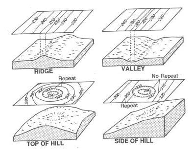
9 CHARACTERISTICS OF CONTOURS 80 v) A series of closed contour lines on the map represent a hill, if the higher values are inside HILL A HILL 17 DEPRESSION: A LOW POINT IN THE GROUND OR SINKHOLE. THEY ARE REPRESENTED BY CLOSE CONTOUR LINES THAT HAVE TICK MARKS POINTING TOWARD LOW GROUND. 18 9

10 CHARACTERISTICS OF CONTOURS 80 vi) A series of closed contour lines on the map indicate a depression if the higher values are outside DEPRESSION A DEPRESSION 19 VALLEY: A STRETCHED-OUT GROOVE IN THE LAND, USUALLY FORMED BY STREAMS OR RIVERS
 Contour line cross ridge or valley line at right angles.")
11 RIDGE: A SLOPING LINE OF HIGH GROUND. 21 CHARACTERISTICS OF CONTOURS vii) Contour line cross ridge or valley line at right angles RIDGE LINE If the higher values are inside the bend or loop in the contour, it indicates a Ridge
12 CHARACTERISTICS OF CONTOURS vii) Contour line cross ridge or valley line at right angles. If the higher values are 100 outside the bend, it represents a Valley VALLEY LINE 23 CHARACTERISTICS OF CONTOURS viii) Contours cannot end anywhere but close on themselves either within or outside the limits of the map
13 CHARACTERISTICS OF CONTOURS ix) Contour lines cannot merge or cross one another on map except in the case of an overhanging cliff OVERHANGING CLIFF 25 CHARACTERISTICS OF CONTOURS x) Contour lines never run into one another except in the case of a vertical cliff. In this case, several contours coincide and the horizontal equivalent becomes zero VERTICAL CLIFF OVERHANGING CLIFF 26 13
14 SADDLE: A DIP OR LOW POINT BETWEEN TWO AREAS OF HIGHER GROUND. 27 CHARACTERISTICS OF CONTOURS X) Depressions between summits is called a saddle. It is represented by four sets of contours as shown. It represents a dip in a ridge or the junction of two ridges. And in the case of a mountain range,it takes the form of a pass SADDLE Line passing through the saddles and summits gives water shed line
15 A valley may look like this Often with a river running down through the valley 29 However a spur can look very similar! But here the heights are increasing in the opposite direction always double check which way the contours are increasing or decreasing

16 Valley Spur 31 Now Try your hand at a short test or click on the return button to re-run this presentation


17 A series of V-shapes indicates a valley and the V s point to higher elevation. 33 Contour lines cannot begin or end on the plan. A contour never splits


18 On uniform slopes, the contour lines are spaced uniformly. No two contours can run into one. 35 Contours deflect uphill at valley lines and downhill at ridge line; line crossing are perpendicular: U-shaped for ridge crossings; V-shaped for valley crossings. Valley Ridge 36 18
19 Example 1 Drawing Contour Lines There is no right or wrong starting point. Pick a contour interval, start at one edge and extend the contour across the map. This example starts with the 14 foot contour. In this example even numbered contours will be used
20 Example 2 Drawing Contour Lines m 40 20
21 41 Since the contour interval is 10m, all contour lines should be multiples of
22 Solution: 43 Example 3 Drawing Contour Lines 44 22

23 Example 4 Drawing Contour Lines 45 Example 5 Drawing Contour Lines 46 23
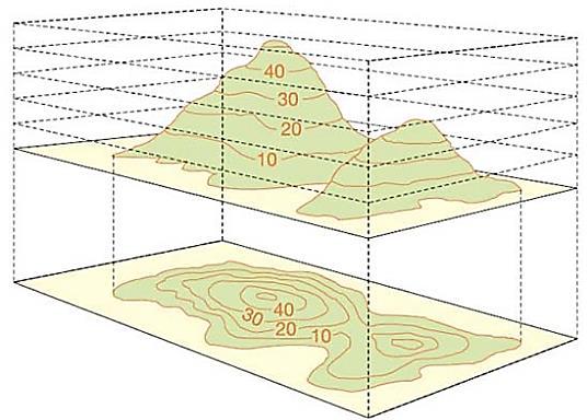
Contour An imaginary line on the ground surface joining the points of equal elevation is known as contour.
 Contour An imaginary line on the ground surface joining the points of equal elevation is known as contour. In other words, contour is a line in which the ground surface is intersected by a level surface
Engineering Surveying -1 CE212 Contouring Lectures. Lecture 2016, November 29 th Muhammad Noman
 Engineering Surveying -1 CE212 Contouring Lectures Lecture 2016, November 29 th Muhammad Noman Contour An Imaginary line on the ground surface joining the points of equal elevation is known as contour.
Surveying & Measurement. Detail Survey Topographic Surveying
 Surveying & Measurement Detail Survey Topographic Surveying Introduction Mapping surveys are made to determine the relief of the earth s surface and locate critical points on it. to determine the locations
A contour line is a line that passes through points having the same elevation.* Definition
 Contour Lines A contour line is a line that passes through points having the same elevation.* Definition Eleven (11) characteristics of contour lines 1. Contour lines are continuous. 2. Contour lines are
Module 2: Mapping Topic 3 Content: Topographic Maps Presentation Notes. Topographic Maps
 Topographic Maps 1 Take a few moments to study the map shown here of Isolation Peak, Colorado. What land features do you notice? Do you thinking hiking through this area would be easy? Did you see the
determining the relative height of different
 Levelling & Contouring Principle of levelling Principle:-The principle of levelling is to obtain horizontal line of sight with respect to which vertical distances of the points above or below this line
ENVI.2030L Topographic Maps and Profiles
 Name ENVI.2030L Topographic Maps and Profiles I. Introduction A map is a miniature representation of a portion of the earth's surface as it appears from above. The environmental scientist uses maps as
Earth Sciences 089G Short Practical Assignment #4 Working in Three Dimensions
 Earth Sciences 089G Short Practical Assignment #4 Working in Three Dimensions Introduction Maps are 2-D representations of 3-D features, the developers of topographic maps needed to devise a method for
COPYRIGHTED MATERIAL. Contours and Form DEFINITION
 1 DEFINITION A clear understanding of what a contour represents is fundamental to the grading process. Technically defined, a contour is an imaginary line that connects all points of equal elevation above
BACKGROUND INFORMATION
 Build an Island INTRODUCTION For this assignment, you will be creating a topographic map and three-dimensional model of a fictional island that you have designed. You will start by exploring some basic
AutoCAD 2016 for Civil Engineering Applications
 Introduction to AutoCAD 2016 for Civil Engineering Applications Learning to use AutoCAD for Civil Engineering Projects Nighat Yasmin Ph.D. SDC P U B L I C AT I O N S Better Textbooks. Lower Prices. www.sdcpublications.com
UNITED STATES MARINE CORPS FIELD MEDICAL TRAINING BATTALION Camp Lejeune, NC
 UNITED STATES MARINE CORPS FIELD MEDICAL TRAINING BATTALION Camp Lejeune, NC 28542-0042 FMST 206 Land Navigation TERMINAL LEARNING OBJECTIVE 1. Given a military topographic map, protractor, and objective,
Maps and map interpretation An introduction for geoscientists
 Maps and map interpretation An introduction for geoscientists Produced by the University of Derby in conjunction with UKOGL Aims This teaching package provides an introduction to maps and how to identify
Land Navigation / Map Reading
 Land Navigation / Map Reading What is the Field Manual for map reading and land navigation? FM 3-25.26 What are the basic colors of a map, and what does each color represent? Black - Indicates cultural
Shoe Box Activity Constructing a Topographic Map
 Shoe Box Activity Constructing a Topographic Map Background Information All maps are models of some feature of the real world. The kind of map oen used by scientists is called a contour or topographic
Roof Tutorial Wall Specification
 Roof Tutorial The majority of Roof Tutorial describes some common roof styles that can be created using settings in the Wall Specification dialog and can be completed independent of the other tutorials.
Topographic Maps. Contour Lines
 Topographic Maps Our first task today will consist of locating ourselves with the help of a topographic map. GPS units that can tell you the location of any Dunkin' Donuts within a five mile radius. Paper
Lab #4 Topographic Maps and Aerial Photographs
 Lab #4 Topographic Maps and Aerial Photographs Purpose To familiarize you with using topographic maps. Visualizing the shape of landforms from topographic maps is an essential skill in geology. Proficiency
1. The topographic map below shows a depression contour line on Earth's surface.
 1. The topographic map below shows a depression contour line on Earth's surface. Points A, B, C, and D represent surface locations. Contour line elevations are in feet. Which profile best shows the topography
1 : 5,000 1cm to 100m
 4.1.1 Scales and Converting Scales In Hong Kong maps, there are 2 types of scales: 1. 1:5000 (Black and white with no color) 2. 1:20000 (With color) If there is no unit in a representative fraction scale,
SURVEYING 1 CE 215 CHAPTER -3-
 Civil Engineering Department SURVEYING 1 CE 215 CHAPTER -3- PROFILE AND CROSS SECTION LEVELING 1 2 1 3 4 2 5 6 3 7 8 4 9 10 5 11 12 6 13 14 7 15 16 8 17 18 9 19 20 10 21 22 11 23 24 12 25 26 13 27 28 14
Ch. 1.3: Topographic Maps
 Ch. 1.3: Topographic Maps StudentS will be able to Explain what are topographic maps Read a topographic map Create a topographic map "Geologists don't dislike classical music, they just prefer rock." Topographic
PRE-LAB for: Introduction to Aerial Photographs and Topographic maps (Ch. 3)
") GEOLOGY 306 Laboratory Instructor: TERRY J. BOROUGHS NAME: PRE-LAB for: Introduction to Aerial Photographs and Topographic maps (Ch. 3) For this assignment you will require: a calculator and metric ruler.
GEOLOGY 306 Laboratory Instructor: TERRY J. BOROUGHS NAME: PRE-LAB for: Introduction to Aerial Photographs and Topographic maps (Ch. 3) For this assignment you will require: a calculator and metric ruler.
GUIDELINES FOR MEASURING BUILDING HEIGHT
 GUIDELINES FOR MEASURING BUILDING HEIGHT THE CITY S POLICIES ON BUILDING HEIGHT In 1994, the City adopted a new General Plan that sets direction for development within Brisbane. Among its policies affecting
Topography and Contouring Teaching Assistant Guide
 Topography and Contouring Teaching Assistant Guide Learning Objectives: At the end of the exercise the students will be able to read a contour map contour data draw a topographic profiles Getting Started
Slope analysis & Grading. Earth shape and earthwork Topographic map Slope form Slope analysis Grading
 6 Slope analysis & Grading Earth shape and earthwork Topographic map Slope form Slope analysis Grading 81 Topographic Map Topographic Contour map Topographic contour map are composed of a series of line
Following are the geometrical elements of the aerial photographs:
 Geometrical elements/characteristics of aerial photograph: An aerial photograph is a central or perspective projection, where the bundles of perspective rays meet at a point of origin called perspective
Introduction to Aerial Photographs and Topographic maps (Chapter 3)
") GEOLOGY 306 Laboratory Instructor: TERRY J. BOROUGHS NAME: Introduction to Aerial Photographs and Topographic maps (Chapter 3) For this assignment you will require: a calculator and metric ruler. Objectives:
GEOLOGY 306 Laboratory Instructor: TERRY J. BOROUGHS NAME: Introduction to Aerial Photographs and Topographic maps (Chapter 3) For this assignment you will require: a calculator and metric ruler. Objectives:
UNIT 4 LEVELLING 4.1 INTRODUCTION. Structure. 4.1 Introduction. 4.2 Definitions of Basic Terms 4.3 Basic Principle 4.4 Instruments and Equipment
 UNIT 4 LEVELLING Levelling Structure 4.1 Introduction Objectives 4.2 Definitions of asic Terms 4.3 asic Principle 4.4 Instruments and Equipment 4.4.1 Different Types of Level 4.4.2 Levelling Staff 4.4.3
Hours / 100 Marks Seat No.
 17419 21415 3 Hours / 100 Seat No. Instructions (1) All Questions are Compulsory. (2) Answer each next main Question on a new page. (3) Illustrate your answers with neat sketches wherever necessary. (4)
The Basics. HECRAS Basis Input. Geometry Data - the basics. Geometry Data. Flow Data. Perform Hydraulic Computations. Viewing the Output
 The Basics HECRAS Basis Input Geometry Data. Flow Data. Perform Hydraulic Computations by G. Parodi WRS ITC The Netherlands Viewing the Output ITC Faculty of Geo-Information Science and Earth Observation
Title: How steep are those hills? Engineering Grade: Estimated Time: 3 hours (2 days) Groups: 3 to 4 students
 Groups: 3 to 4 students") Title: How steep are those hills? Engineering Grade: 10-12 Estimated Time: 3 hours (2 days) Groups: 3 to 4 students Synopsis: Students will be able to understand the concept of surveying and mapping ground
Title: How steep are those hills? Engineering Grade: 10-12 Estimated Time: 3 hours (2 days) Groups: 3 to 4 students Synopsis: Students will be able to understand the concept of surveying and mapping ground
31, The following isoline map shows the variations in the relative strength of Earth's magnetic field from 1 (strong) to 11 (weak).
 to 11 (weak).") 31, The following isoline map shows the variations in the relative strength of Earth's magnetic field from 1 (strong) to 11 (weak). 33. The following four temperature field maps represent the same region
31, The following isoline map shows the variations in the relative strength of Earth's magnetic field from 1 (strong) to 11 (weak). 33. The following four temperature field maps represent the same region
Introduction to Aerial Photographs and Topographic maps (Chapter 7, 9 th edition) or (chapter 3, 8 th edition)
 or (chapter 3, 8 th edition)") GEOLOGY 306 Laboratory Instructor: TERRY J. BOROUGHS NAME: Introduction to Aerial Photographs and Topographic maps (Chapter 7, 9 th edition) or (chapter 3, 8 th edition) For this assignment you will require:
GEOLOGY 306 Laboratory Instructor: TERRY J. BOROUGHS NAME: Introduction to Aerial Photographs and Topographic maps (Chapter 7, 9 th edition) or (chapter 3, 8 th edition) For this assignment you will require:
Important Questions. Surveying Unit-II. Surveying & Leveling. Syllabus
 Surveying Unit-II Important Questions Define Surveying and Leveling Differentiate between Surveying and Leveling. Explain fundamental Principles of Surveying. Explain Plain and Diagonal Scale. What is
In this section, we find equations for straight lines lying in a coordinate plane.
 2.4 Lines Lines In this section, we find equations for straight lines lying in a coordinate plane. The equations will depend on how the line is inclined. So, we begin by discussing the concept of slope.
TOPOGRAPHIC MAPS A NEW WAY TO VIEW THE WORLD!
 TOPOGRAPHIC MAPS A NEW WAY TO VIEW THE WORLD! http://courtneyjennings.weebly.com/unit-4---weathering-erosiontopo-maps-past.html A topographic map, simply put, is a two-dimensional representation of a portion
Basic Surveying. Kabul, Afghanistan February 2011
 Basic Surveying Kabul, Afghanistan February 2011 1 This watershed rehabilitation and restoration training was prepared by the U.S. Department of Agriculture (USDA) team of Jon Fripp (Civil Engineer USDA/NRCS),
CHAPTER 3-LAB 1: A TOPOGRAPHIC MAP IN THREE DIMENSIONS
 Name Teacher Period Date CHAPTER 3-LAB 1: A TOPOGRAPHIC MAP IN THREE DIMENSIONS Introduction A topographic map shows the shape ofthe land surface with contour lines. On page 29 you will find Figure 3-6,
AIM. What is-a contour map? 23-
 .. '; AIM 23- What is-a contour map?.,,.,, I. There are many different kinds of maps. The maps we use most often are surface maps. A surface map is a drawing. It shows all or part of the earth's surface.
How to install your Landroid
 How to install your Landroid 4 The installation of the Landroid is easy. Depending on the size of your garden, the entire process only takes a short amount of time. If you are like us, you hate wasting
Lab #8: Topographic Map Lab
 NAME: LAB TIME: TA NAME: Lab #8: Topographic Map Lab Topography is the shape of the land. Topographic maps are used to aid in the visualization of the shape of the land. Topographic maps include the accurate
Level Curves, Partial Derivatives
 Unit #18 : Level Curves, Partial Derivatives Goals: To learn how to use and interpret contour diagrams as a way of visualizing functions of two variables. To study linear functions of two variables. To
Suveying Lectures for CE 498
 Suveying Lectures for CE 498 SURVEYING CLASSIFICATIONS Surveying work can be classified as follows: 1- Preliminary Surveying In this surveying the detailed data are collected by determining its locations
3.2 Exercises. rise y (ft) run x (ft) Section 3.2 Slope Suppose you are riding a bicycle up a hill as shown below.
 run x (ft) Section 3.2 Slope Suppose you are riding a bicycle up a hill as shown below.") Section 3.2 Slope 261 3.2 Eercises 1. Suppose ou are riding a biccle up a hill as shown below. Figure 1. Riding a biccle up a hill. a) If the hill is straight as shown, consider the slant, or steepness,
Section 3.2 Slope 261 3.2 Eercises 1. Suppose ou are riding a biccle up a hill as shown below. Figure 1. Riding a biccle up a hill. a) If the hill is straight as shown, consider the slant, or steepness,
8/17/2014. Process of directly or indirectly measuring vertical distances to determine the elevation of points or their differences in elevation
 Process of directly or indirectly measuring vertical distances to determine the elevation of points or their differences in elevation Leveling results are used: To design highways, railroads, canals, sewers,
Existing and Design Profiles
 NOTES Module 09 Existing and Design Profiles In this module, you learn how to work with profiles in AutoCAD Civil 3D. You create and modify profiles and profile views, edit profile geometry, and use styles
MAKE A CO NTO U R MAP
 Your web browser (Safari 7) is out of date. For more security, comfort and the best experience on this site: Update your browser Ignore Activitydevelop Student Version MAKE A CO NTO U R MAP How does a
NAME: PERIOD: DATE: LAB PARTNERS: LAB #6 DRAWING A CONTOUR MAP FROM A THREE DIMENSIONAL MODEL
 NAME: PERIOD: DATE: LAB PARTNERS: LAB #6 DRAWING A CONTOUR MAP FROM A THREE DIMENSIONAL MODEL INTRODUCTION Since land distances and elevations on the earth's surface can be very great it is necessary to
Section 1.3. Slope of a Line
 Slope of a Line Introduction Comparing the Steepness of Two Objects Two ladders leaning against a building. Which is steeper? We compare the vertical distance from the base of the building to the ladder
GEO-SLOPE International Ltd, Calgary, Alberta, Canada Relief Well Spacing
 1 Introduction Relief Well Spacing Relief wells are commonly installed on the downstream side of an earth dam to control the seepage and pore-pressures (e.g. levee; Figure 1). A key design requirement
Line Graphs. Name: The independent variable is plotted on the x-axis. This axis will be labeled Time (days), and
, and") Name: Graphing Review Graphs and charts are great because they communicate information visually. For this reason graphs are often used in newspapers, magazines, and businesses around the world. Sometimes,
Name: Graphing Review Graphs and charts are great because they communicate information visually. For this reason graphs are often used in newspapers, magazines, and businesses around the world. Sometimes,
appendix f: slope density
 CONTENTS: F-2 Statement of Purpose F-3 Discussion of Slope F-4 Description of Slope Density The Foothill Modified Slope Density The Foothill Modified 1/2 Acre slope density The 5 20 slope density F-7 How
Question bank. Unit 1: Introduction
 Question bank Unit 1: Introduction 1. Define surveying. 2. State the objects of surveying 3. State and explain the principle of surveying 4. State and explain the classification of surveying 5. Differentiate
SECTION 3. Housing. FAppendix F SLOPE DENSITY
 SECTION 3 Housing FAppendix F SLOPE DENSITY C-2 Housing Commission Attachment B Appendix F Slope Density STATEMENT OF PURPOSE This appendix has been prepared with the intent of acquainting the general
The Hudson River Illusion: How the Optical Illusions behind Anti-Gravity Hills Affects the River that Flows Two Ways
 The Hudson River Illusion: How the Optical Illusions behind Anti-Gravity Hills Affects the River that Flows Two Ways by, David J. Jackowe, MD The Hudson River looks tilted. Stand on top of Main Street
SPECIFICATION FOR TOPOGRAPHIC AND HYDROGRAPHIC SURVEYS OF RECLAMATION AND DREDGING WORKS
 23 August 2001 SPECIFICATION FOR TOPOGRAPHIC AND HYDROGRAPHIC SURVEYS OF RECLAMATION AND DREDGING WORKS 1.0 EXTENT OF WORKS The main survey works shall comprise of the following : a. Carry out topographic
Magnetic Field of the Earth
 Magnetic Field of the Earth Name Section Theory The earth has a magnetic field with which compass needles and bar magnets will align themselves. This field can be approximated by assuming there is a large
LONGITUDINAL PROFILE COMPLETION
 LONGITUDINAL PROFILE COMPLETION Vertical alignment of the ditch bottom determine using cross-sections plot (refer to fig. 0630) according to the chainage direction: ditch bottom on right side... dotted
SolidWorks Design & Technology
 SolidWorks Design & Technology Training Course at PHSG Ex 5. Lego man Working with part files 8mm At first glance the Lego man looks complicated but I hope you will see that if you approach a project one
Graphs of linear equations will be perfectly straight lines. Why would we say that A and B are not both zero?
 College algebra Linear Functions : Definition, Horizontal and Vertical Lines, Slope, Rate of Change, Slopeintercept Form, Point-slope Form, Parallel and Perpendicular Lines, Linear Regression (sections.3
Hours / 100 Marks Seat No.
 17419 21314 3 Hours / 100 Seat No. Instructions (1) All Questions are Compulsory. (2) Answer each next main Question on a new page. (3) Illustrate your answers with neat sketches wherever necessary. (4)
REVIEW TOPICS CEEN 2320 FINAL EXAM
 REVIEW TOPICS CEEN 2320 FINAL EXAM Be familiar with all materials covered in class, your class handouts and the notes you took in class, your homework assignments, test questions, formulas, tables, figures.
Floods On The Minnesota River Planning For St. Peter
 Floods On The Minnesota River Planning For St. Peter Group Members Section: A B C D E In this lab, we will make a flood hazard map for the city of St. Peter. We will use the 100-year flood as the design
QUANTITY SURVEYS. Introduction
 QUANTITY SURVEYS Introduction In engineering surveying, we often consider a route (road, sewer pipeline, channel, etc.) from three distinct perspectives. The plan view of route location is the same as
Investigating the equation of a straight line
 Task one What is the general form of a straight line equation? Open the Desmos app on your ipad If you do not have the app, then you can access Desmos by going to www.desmos.com and then click on the red
Leveling. Double-Rodded Leveling. Illustrative Problem. Double-Rodded Leveling 8/17/2014
 Double-Rodded Leveling Double-Rodded Leveling A method of determining the differences in elevation between points by employing two level routes simultaneously Two turning points are established such that
Option 1. Design Options are diverse e.g. new route alignments covering a wide area. Option 2. Design Options are restricted
 MINIMUM STANDARD Z/16 SURVEY SPECIFICATIONS 1. GENERAL This specification sets out the Consultant s requirements for topographical survey (ground and aerial) for the Detailed Business Case (DBC) and Pre-Implementation
MAPPING YOUR STREAM. TIME REQUIRED 50 minutes in Field 50 minutes in Classroom 50 minutes Homework
 OUR MAPPING YOUR STREAM STREAM ACTIVITY SUMMARY Students will draft a cross-sectional profile of the stream and measure the velocity of the current. They will use both of these to calculate the discharge
Table of Contents Problem Solving with the Coordinate Plane
 GRADE 5 UNIT 6 Table of Contents Problem Solving with the Coordinate Plane Lessons Topic 1: Coordinate Systems 1-6 Lesson 1: Construct a coordinate system on a line. Lesson 2: Construct a coordinate system
PASS Sample Size Software
 Chapter 945 Introduction This section describes the options that are available for the appearance of a histogram. A set of all these options can be stored as a template file which can be retrieved later.
Chapter 9 Linear equations/graphing. 1) Be able to graph points on coordinate plane 2) Determine the quadrant for a point on coordinate plane
 Be able to graph points on coordinate plane 2) Determine the quadrant for a point on coordinate plane") Chapter 9 Linear equations/graphing 1) Be able to graph points on coordinate plane 2) Determine the quadrant for a point on coordinate plane Rectangular Coordinate System Quadrant II (-,+) y-axis Quadrant
Chapter 9 Linear equations/graphing 1) Be able to graph points on coordinate plane 2) Determine the quadrant for a point on coordinate plane Rectangular Coordinate System Quadrant II (-,+) y-axis Quadrant
Subdivision Cross Sections and Quantities
 NOTES Module 11 Subdivision Cross Sections and Quantities Quantity calculation and cross section generation are required elements of subdivision design projects. After the design is completed and approved
Gradient and Rate of Change
 Name: 1. Base your answer(s) to the following question(s) on the topographic map shown below. Letters A, B, C, and D represent locations on Earth s surface. The symbol marks the highest elevation on Patty
3.1 Start Thinking. 3.1 Warm Up. 3.1 Cumulative Review Warm Up
 3.1 Start Thinking Sketch two perpendicular lines that intersect at point. Plot one point on each line that is not. all these points and. onnect and to make. What type of figure do points,, and make? ould
SABAT CONSULTING GROUP PAYDIRT 4 TRAINING MANUAL. Support Numbers: SABAT: / GTCO / PAYDIRT:
 SABAT CONSULTING GROUP PAYDIRT 4 TRAINING MANUAL Support Numbers: SABAT: 905-850-9633 / GTCO 800-344-4723 / PAYDIRT: 800-235-4972 Digitizer Setup Codes: / QR: S + 0+1 / SW: S + 0+ 1 PAYDIRT OTHER SUPPORT:
SUMMIT COUNTY PLANNING AND ENGINEERING DEPARTMENT
 SUMMIT COUNTY PLANNING AND ENGINEERING DEPARTMENT SINGLE-FAMILY SITE PLAN INFORMATION PACKET GENERAL INFORMATION This information packet explains how your application for a single-family site plan will
Contact Us : E Surveying Solutions AMR #7, Circular ring Road Nandini Layout Bangalore Karnataka, India. Phone:
 E Surveying Solutions work towards bring the survey community together and utilize your engineering and our software skills to deliver effective services, by introducing cutting edge technology at an affordable
LD20558-L Parking Lots with AutoCAD Civil 3D Corridors
 LD20558-L Parking Lots with AutoCAD Civil 3D Corridors Steven Hill CAD Manager, Civil Designer / Geosyntec Consultants.NET Application Developer / Red Transit Consultants, LLC Learning Objectives Discover
Installation Instructions. Tools Needed. Tape measure. Level. Shovel or Post hole digger. Concrete. Drill. Stakes. Mallet or hammer.
 Installation Guide EcoStone Fence 1330 West 400 North Orem, UT 84057 Toll Free 1.866.648.9336 Tel. 1.801.655.5236 Fax 1.801.655.5240 www.ecostonefence.com Installation Instructions Introduction. These
An Inclined Plane. wooden block with a hook. Vernier computer interface. Figure 1: Using the Dual-Range Force Sensor
 Dual-Range Force Sensor An Inclined Plane Experiment 22 An inclined plane is a slanted surface used to raise objects. The sloping floor of a theater, a road over a mountain, and a ramp into a building
Pearson's Ramp-Up Mathematics
 Introducing Slope L E S S O N CONCEPT BOOK See pages 7 8 in the Concept Book. PURPOSE To introduce slope as a graphical form of the constant of proportionality, k. The lesson identifies k as the ratio
ESCONDIDO FIRE DEPT TRAINING MANUAL Section Truck Module Page 1 of 8 Ventilation Residential Operations Revised
 Truck Module Page 1 of 8 RESIDENTIAL OPERATIONS VERTICAL Vertical ventilation for residential application will involve a minimum of two personnel with two ladders raised on the structure as soon as operationally
Book 10: Slope & Elevation
 Math 21 Home Book 10: Slope & Elevation Name: Start Date: Completion Date: Year Overview: Earning and Spending Money Home Travel and Transportation Recreation and Wellness 1. Budget 2. Personal Banking
TOWN OF DOUGLAS EARTH REMOVAL SPECIAL PERMIT APPLICATION FORM Pursuant to Section 6.1 of the Douglas Zoning Bylaw
 I. Owner Information II. Applicant Information III. Representative Information IV. Operator Information er.doc Page 1 of 5 Douglas Planning Board V. Site Information Assessors Map Assessors Parcel Deed
East Bay Municipal Utility District. Study Guide for Survey Technician I
 East Bay Municipal Utility District Study Guide for Survey Technician I Summer 2018 TABLE OF CONTENTS PAGE Introduction... 1 Scoring... 1 Visual Perception... 2 Sample Questions 1-2... 2 Reading and Interpreting
PHOTOGRAMMETRY STEREOSCOPY FLIGHT PLANNING PHOTOGRAMMETRIC DEFINITIONS GROUND CONTROL INTRODUCTION
 PHOTOGRAMMETRY STEREOSCOPY FLIGHT PLANNING PHOTOGRAMMETRIC DEFINITIONS GROUND CONTROL INTRODUCTION Before aerial photography and photogrammetry became a reliable mapping tool, planimetric and topographic
Laminated Shingles. Landmark Series and Landmark TL. CertainTeed Shingle Applicator s Manual
 CertainTeed Shingle Applicator s Manual Laminated Shingles 12 Landmark Series and Landmark TL YOUR OBJECTIVE: To learn the correct procedure for installing Laminated shingles. LANDMARK SERIES AND LANDMARK
To determine the difference in levels of points/objects. To determine the depth cutting and filling in engineering works.
 UET-11-CE-SCET WAH SURVEYING-I Dumpy (Wye) Level LEVELLING: It is a surveying method used to determine the level of points/objects with reference to the selected datum. It is also used to set out engineering
Scientific Investigation Use and Interpret Graphs Promotion Benchmark 3 Lesson Review Student Copy
 Scientific Investigation Use and Interpret Graphs Promotion Benchmark 3 Lesson Review Student Copy Vocabulary Data Table A place to write down and keep track of data collected during an experiment. Line
STATE UNIVERSITY CONSTRUCTION FUND
 DIRECTIVE 1C-12 Issue date: August 2012 1. General SURVEY, MAPPING AND UTILITY LOCATING This Directive has been developed as a general guide for the survey and mapping effort required for Fund projects.
b. Building Areas or Building Pads having an average grade steeper than 5% (some elevation information may be required to verify grade).
.") Snyderville Basin G. Site Plan Requirements: Three (3) copies of a site plan, a minimum size of 11" x 17" (must be legible) and a maximum size of 36" x 48" shall be submitted with all building permit applications
Snyderville Basin G. Site Plan Requirements: Three (3) copies of a site plan, a minimum size of 11" x 17" (must be legible) and a maximum size of 36" x 48" shall be submitted with all building permit applications
Location of Structure on Site
 Chapter 1 Location of Structure on Site A number of factors affect the location of a structure on a site, as well as the type of building that may be erected. Once the site is chosen, different methods
Watershed Topography
 Watershed Topography Adapted from: An original Creek Connections activity. Creek Connections, Allegheny College, Meadville, Pennsylvania, 16335 Topography in Watersheds Grade Level: Basic to intermediate.
Survey Requirements. Design Guidelines and Standards. June Office of the University Architect
 Design Guidelines and Standards Survey Requirements June 2004 Office of the University Architect Construction Management P.O. Box 210181 Cincinnati, Ohio 45221-0181 Table of Contents Survey Requirements
Constructing Line Graphs*
 Appendix B Constructing Line Graphs* Suppose we are studying some chemical reaction in which a substance, A, is being used up. We begin with a large quantity (1 mg) of A, and we measure in some way how
Introduction to Surveying. Chapter -One-
 Introduction to Surveying Chapter -One- 1 GENERAL INFORMATION FALL 2016 Assistant Lecturer : Asmaa Abdulmajeed Research Assistant: Zanyar Bazyan Course Title : Surveying 1 Course Code : CE 215 Class No
LEVELING. Definitions
 Definitions An elevation of a point : The vertical distance between the point and the reference level surface ( datum ),the most commonly used datum is the mean sea level (MSL ). Leveling : The process
Essential Skills: Reading and Interpreting Maps and Plans
 Essential Skills: Reading and Interpreting Maps and Plans Prepared for: NEW YORK STATE PLANNING FEDERATION April 14, 2015 Prepared by: BME ASSOCIATES Peter G. Vars, P.E. Stages of Plan Review Concept /
47 CFR Ch. I ( Edition)
") 73.684 should decrease more rapidly with distance beyond the horizon than for Channels 2 6, and modification of the curves for Channels 14 69 may be expected as a result of measurements to be made at a
73.684 should decrease more rapidly with distance beyond the horizon than for Channels 2 6, and modification of the curves for Channels 14 69 may be expected as a result of measurements to be made at a