GUIDELINES FOR MEASURING BUILDING HEIGHT
|
|
|
- Jesse Watson
- 6 years ago
- Views:
Transcription
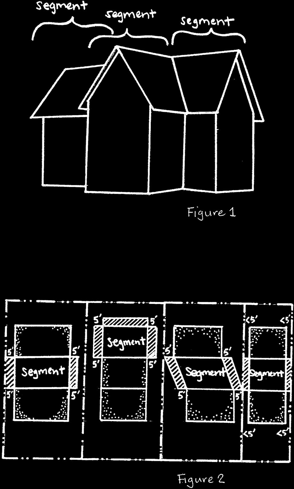
1 GUIDELINES FOR MEASURING BUILDING HEIGHT THE CITY S POLICIES ON BUILDING HEIGHT In 1994, the City adopted a new General Plan that sets direction for development within Brisbane. Among its policies affecting development, the General Plan intends to encourage options that minimize grading and transformation of the landform and fit comfortably with the topography (Program 18a; also see Policies 43, 245 & 312 and Program H8a). The General Plan also addresses regulating height to protect the character of established neighborhoods and to preserve public views of the Mountain and the Bay (see Policies 11, 252 & and Programs 22b, 22d, 22f, 252a, 275a, 330a & 330.b). The General Plan deals directly with the method of determining building height in Program 22a, Consider amendments to the Zoning Ordinance which contain clear and defined standards to protect creativity and diversity in design while addressing issues of height, scale, mass and articulation. As part of the City s implementation of the General Plan, a new definition of height of structures was adopted in 1998, incorporating elements from the Uniform Building Code, so that in most cases buildings would be measured from finished grade, rather than from natural grade, as had been done previously. Finished grade provides a more stable reference point, since natural grade is often eliminated during the course of construction. This change would also eliminate the occasional incongruity between the visible height of a building and its defined height, if a significant portion of the site had been graded away so that one or more stories were now below what had been natural grade. Note that technical terms shown in italics are defined on the last page. WHAT YOU NEED TO MEASURE BUILDING HEIGHT 1. A topographical map or survey of the existing and proposed (finished) grades of the site. Existing grade is typically shown by solid lines, while proposed grade is indicated by dashed lines. The topographical map should show the changes in the grade or slope of a site in 2 ft. minimum increments. The increments (relative elevations) are identified relative to sea level or other accepted point of reference, such as one of the City s survey monuments. 2. A site plan, showing the boundaries of the property and the location of the existing/proposed building, atop the topographical map. 3. Views (also called architectural elevations ) of each of the sides of the building, drawn to scale (such as ¼ inch equals 1 foot). Typically, views sliced through the building ( sectional views ) to show interior floors are also provided; these show the relative elevation of each finished floor and other portions of the building, such as exterior walls hidden by overhanging eaves, which can be useful in calculating the height of the structure. 1
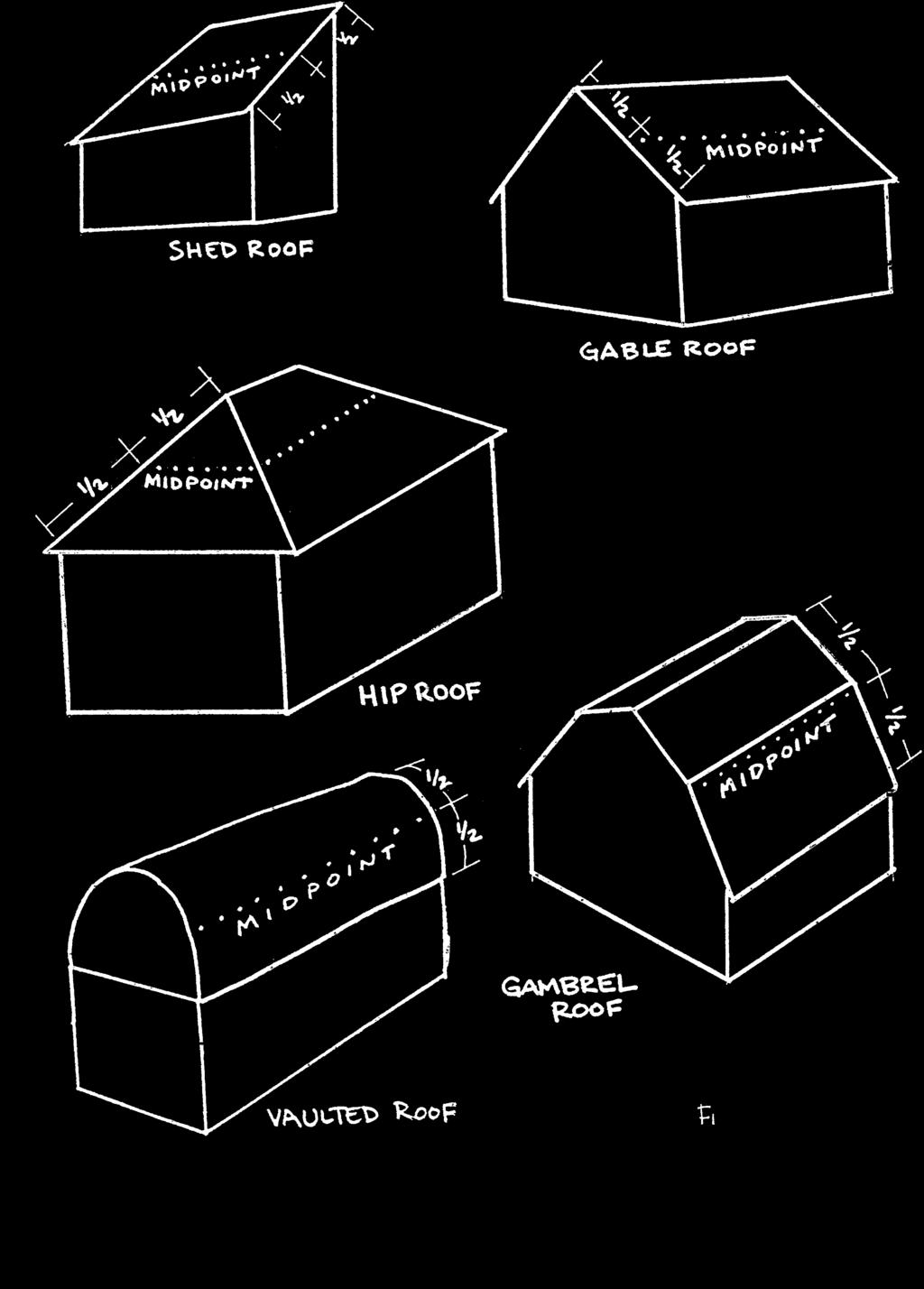
2 HOW TO MEASURE BUILDING HEIGHT 1. Break up the building into segments, based upon changes in the roofline of the building (see Figure 1). 2. Include bays and similar building projections, as well as dormers, towers and similar rooftop elements, when identifying the segments. 3. For each segment, identify the reference datum, which is the lowest finished grade on that portion of the site not exceeding 5 ft. between the segment and the adjoining property line. The 5 ft. distance should be measured from the segment perpendicular to the property line. Where finished grade differs from one side to the other of a segment, the lower of the two will be the reference datum. For the front or rear segment, finished grade toward the front or rear property line must be considered, in addition to finished grade at the sides (see Figure 2). 4. When finished grade has been artificially raised above natural grade through backfilling, the reference datum shall be the lowest point of elevation of the natural grade prior to the placement of the fill rather than the finished grade. However, where the Planning Commission has approved the contour grading of a site through roughly balanced combinations of cut and fill, the finished grade may be used as the reference datum instead of the natural grade.. 5. For each segment, determine what type of roofline it has and then identify its relative elevation, based upon the following: For a flat or minimally pitched (less than 1:12) roof, use the relative elevation of the top of the roof, including any parapets or coping; For a mansard roof, use the relative elevation of the deck line; For a shed, gable, hip, gambrel or vaulted roof, use the relative elevation at the midpoint of the pitch of the roof, measured from the peak of the roof to that point vertically above the highest exterior wall, including dormer walls (see Figure 3); where the midpoint differs from one side of such a roof to another, the midpoint with the greatest relative elevation should be used. 6. Subtract the reference datum from the relative elevation of the roofline to calculate the height of each segment. The greatest difference is the height of the structure. 2
3

4
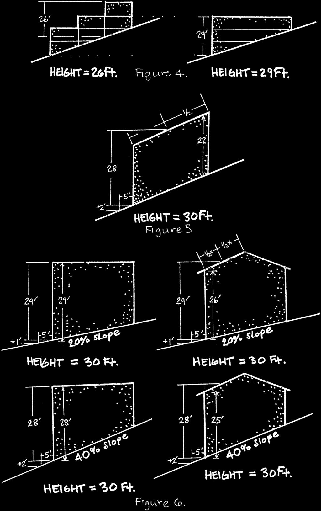
5 IMPLICATIONS OF THE CITY S METHOD OF MEASURING BUILDING HEIGHT Caution should be taken in designing buildings to make sure that they comply with the City s height limits. Sometimes, the simpler the building, the greater its height. Height is not necessarily measured from the top of the building to the bottom. While from a distance, for example, a building containing four floors that step up or down a hillside in three two-story segments may look taller than the three-story, single-segment building next door, the opposite may be the case. Because height is measured per segment, a building made up of multiple segments can have a lower height than one made of a single segment (see Figure 4). The height of a building might be greater than its vertical dimension at any one point. Even though a pitched roof might parallel the slope below at a uniform vertical distance above grade, its height as measured by the City might be greater. This is because the height of a structure is not measured vertically from the midpoint of the pitch of the roof to finished grade below; instead, height is measured as the difference in relative elevation between the midpoint of the pitch of the roof and the reference datum which will typically be finished grade lower down the slope from the midpoint (see Figure 5). A 30 ft. height limit doesn t always accommodate a 30 ft. tall building. While the 30 ft. height limit that applies to sites with slopes of 20% or more would appear to allow 3-story buildings, this isn t necessarily the case on steep hillsides or where greater than minimum standard ceiling heights are proposed. Note, too, that 3- story buildings may be subject to additional requirements and restrictions under the Uniform Building Code, regarding side setbacks, secondary exits, and other safety and design standards. The steeper the site, the greater the effect on the height of the building. On sloped sites, the relative elevation of the reference datum on the downslope side of the building drops proportionately to the percentage of slope. For example, on a site with a 40% downslope, the relative elevation drops 2 feet for each 5 feet in horizontal distance, in turn adding 2 ft. to the height of a building if measured from the reference datum 5 feet from the rear of such a building (see Figure 6). The effect is intensified when the slope of a site does not drop consistently, but instead becomes steeper. HEIGHT LIMIT SITE SLOPE HEIGHT DIFFERENTIAL 28 ft. 0% minus 0 ft. 10% minus 0.5 ft. 30 ft. 20% minus 1 ft. 30% minus 1.5 ft. 40% minus 2 ft. 50% minus 2.5 ft. 5
6
7 Peaked roofs are encouraged, but take careful measurements. The idea behind measuring the height of a peaked roof from the midpoint of its pitch was that even though the peaked roof would extend higher than a flat roof of the same height as measured by the City s method, the mass of the two buildings in section would be approximately equal. Because the height at the midpoint of the roof is measured relative to a point at finished grade that may be a significant distance horizontally and vertically away, it is not always guaranteed that the height of a peaked roof under the City s definition will be less than a flat roof. This is particularly true if the peak is not centered on the building and if the slope of the site is skewed. A simple shed ( pitched ) roof designed to parallel a hillside 30 ft. below cannot be assumed to comply with the 30 ft. height limit; it must be specifically measured using the City s method. Articulation is encouraged, but take careful measurements. The City s zoning regulations are intended to discourage boxy buildings and to encourage designs that break up a building s bulk with pop-outs and insets. Sometimes, though, this added articulation can have height implications. Certain forms of articulation, such as dormers that project above rooflines, will increase the height of a building under the City s method of measurement. Providing parking is required, but take careful measurements. Parking is required to be provided. Sometimes, though, it may be difficult to juggle the City s parking standards and height limits, particularly on upslope sites. For example, driveways cannot have a slope steeper than a 20%, which sometimes means that the driveway and garage have to be cut into the hillside. Even though the rest of the building might remain above natural grade, the height of the front of the garage (and the rest of the building atop it) will be measured from the finished grade of the driveway. 7
8 TERMINOLOGY FINISHED GRADE the final elevation of the ground surface after completion of all site preparation and development, per Brisbane Municipal Code Section A. HEIGHT OF STRUCTURE the vertical distance above a reference datum measured to the highest point of the coping of a flat roof or to the deck line of a mansard roof or to the average height of the highest gable of a pitched or hipped or vaulted roof. The reference datum shall be the lowest point of elevation of the finished grade between the building and the property line when the property line is five (5) feet or less from the building. When the property line is more than five (5) feet from the building, the reference datum shall be the lowest point of elevation of the finished grade between the building and a line five (5) feet from the building. When the finished grade results from fill, the reference datum shall be the lowest point of elevation of the natural grade prior to the placement of the fill. In the case of a stepped or terraced building, each segment of the building shall be separately measured and the height of the building shall be the maximum height of the highest segment, per Brisbane Municipal Code Section A (also see Brisbane Municipal Code Section F). PROJECTION any roofed portion of a building which projects outward from a wall (such as a cantilevered bay) or any deck which projects outward from a wall when the deck also serves as a roof for an area below with at least 7 ft. of clearance (see Brisbane Municipal Code Sections and ). REFERENCE DATUM a term used to describe the point from which the height of a building is measured; see Height of Structure for its specific use. RELATIVE ELEVATION the height of a point of ground or a portion of a building relative to sea level or some other accepted point of reference, such as one of the City s survey monuments. ROOFLINE the form a building s roof creates by its type (such as flat, mansard, gable, or hip) and/or its orientation (such as when the ridge of a roof changes direction in an L shape); it is such variations that may give a building a stepped or terraced appearance. SEGMENT--each portion of the building with a different roofline; in some cases, bays, decks and dormers may be considered separate segments. For example, a deck which covers another deck or porch, thus resulting in floor area as defined by BMC Section A, would be considered a separate segment. 8
9 ADDITIONAL INTERPRETATIONS: A bay or other projection from the face of a building is not counted as a separate segment. Finish grade is taken 5 ft. from the foundation/supports of the building, not from any overhang or bay. The height of a flat roof with a roof deck railing is measured from the deck line, as is done for mansard roofs. On a site with a cross slope, for the height of a building segment to be measured from the upslope finish grade, the building segment must be inset from the downslope side of the building footprint by at least half the width of the building. 9
Roof Tutorial Wall Specification
 Roof Tutorial The majority of Roof Tutorial describes some common roof styles that can be created using settings in the Wall Specification dialog and can be completed independent of the other tutorials.
Architrave: The molded from or ornament surrounding a window, door or other rectangular opening.
 Section 8. Definitions. Architrave: The molded from or ornament surrounding a window, door or other rectangular opening. Bay Window: A window that projects out from the surface of an exterior wall and
NEW SINGLE FAMILY HOMES
 NEW SINGLE FAMILY HOMES Your submission must include the following to be accepted as a complete application: 1 copy of the deed and / or purchase and sales agreement if you have owned the property less
CHICAGO LANDMARKS PERMIT APPLICATION AND PRE-PERMIT SUBMISSION REQUIREMENTS
 CHICAGO LANDMARKS PERMIT APPLICATION AND PRE-PERMIT SUBMISSION REQUIREMENTS The Commission on Chicago Landmarks reviews all permit applications for work to designated and proposed Chicago Landmarks and
Article 4.0 Measurements and Exceptions
 This Article identifies and explains some of the more common forms of measurement used throughout this Ordinance. It also specifies exceptions to certain requirements of this Ordinance. Sec. 4.1 Measurements
MULTIPLE-FAMILY DESIGN REVIEW SUBMITTAL CHECKLIST
 MULTIPLE-FAMILY DESIGN REVIEW SUBMITTAL CHECKLIST This application lists the content and format of the submittal requirements to initiate the Design Review process. An incomplete application will not be
SMALL PROJECTS & IMPROVEMENTS: DOG RUNS, PATIO ENCLOSURES & FENCES, EXTERIOR IMPROVEMENTS (Abbreviated Design Review Application)
") REVIEW TYPE: PRELIMINARY FINAL LANDSCAPE ABBREVIATED ADDITION COLOR BOARD Application Form* X X X X X Design Review Fee* X X X Registered Survey** X Site Plan X X X X X Floor Plans X X X Elevations X X
REVIEW TYPE: PRELIMINARY FINAL LANDSCAPE ABBREVIATED ADDITION COLOR BOARD Application Form* X X X X X Design Review Fee* X X X Registered Survey** X Site Plan X X X X X Floor Plans X X X Elevations X X
COPYRIGHTED MATERIAL. Contours and Form DEFINITION
 1 DEFINITION A clear understanding of what a contour represents is fundamental to the grading process. Technically defined, a contour is an imaginary line that connects all points of equal elevation above
Part 4: Visitability Ordinance. City of Austin Development Services Department
 Part 4: Visitability Ordinance Submittal Requirements Interior visitability Plan with graphic notations OR Plan with descriptive notes Exterior Visitability July 1, 2015 Plan showing Exterior Route and
Installation Instructions
 Installation Instructions SHARK VENT XLP / XTRA Page Installation Considerations 3 Shark Vent XLP & Xtra General Installation 4 Steep Pitch Guidelines 5 Asphalt Shingles Detail 6 Ridge Beam Detail 7 Hip
Recommended Changes to the Public Hearing Draft Zoning Ordinance
 DATE: December 6, 2016 TO: Village of Oak Park FROM: Arista Strungys SUBJECT: Recommended Changes Recommended Changes to the Public Hearing Draft Zoning Ordinance ZONING MAP» Edit to remove right-of-way
WIRELESS TELECOMMUNICATION FACILITIES. Chapter 15
 Title 9 Land Management Code WIRELESS TELECOMMUNICATION FACILITIES Chapter 15 9-15-1: PURPOSE: 9-15-2: DEFINITIONS: 9-15-3: APPLICABILITY: 9-15-4: MASTER PLAN REQUIRED: 9-15-5: ALLOWABLE USES: 9-15-6:
A contour line is a line that passes through points having the same elevation.* Definition
 Contour Lines A contour line is a line that passes through points having the same elevation.* Definition Eleven (11) characteristics of contour lines 1. Contour lines are continuous. 2. Contour lines are
SUMMIT COUNTY PLANNING AND ENGINEERING DEPARTMENT
 SUMMIT COUNTY PLANNING AND ENGINEERING DEPARTMENT SINGLE-FAMILY SITE PLAN INFORMATION PACKET GENERAL INFORMATION This information packet explains how your application for a single-family site plan will
DRAFT V. SITE ELEMENTS SIGNS
 1. SIGNS Intent Signs are an important streetscape design element that affect not only the visual character of the Historic District but also the vitality of its businesses. Signage provides business identification,
Installation Instructions
 Installation Instructions XTRACTOR VENT X18 / X18 XTRA / XLP Page Installation Considerations 3 X18 and X18 Xtra General Installation 4 XLP General Installation 5 Steep Pitch Guidelines 6 Asphalt Shingles
Landmarks Preservation Commission Tacoma Economic Development Department Culture and Tourism Division
 Tacoma Economic Development Department Culture and Tourism Division 747 Market Street Room 1036 Tacoma WA 98402-3793 253.591.5220 APPLICATION FOR DESIGN REVIEW FOR SINGLE FAMILY RESIDENTIAL PROPERTIES
Module 1: Building Model Creation
 INSTRUCTIONAL MODULES DEMONSTRATING BUILDING ENERGY ANALYSIS USING A BUILDING INFORMATION MODEL Christian Daniel Douglass Industrial and Enterprise Systems Engineering December 1, 2010 Module Summary In
Truman Heritage District Design Guidelines. Glossary
 Glossary Glossary Alignment, the linear relationship of buildings along a streetscape. Baluster, an upright member supporting a railing or bannister. Bargeboard Balustrade, a porch or stair railing composed
A Visual Field Guide. Village of Danforth Historic Resource Survey. Syracuse, New York. for the
 The Village of Danforth Historic Resources Survey, Syracuse, New York A Visual Field Guide for the Village of Danforth Historic Resource Survey Syracuse, New York 217 Montgomery Street, Suite 1000 Syracuse,
Certificate of Appropriateness (CoA) Checklist
 Checklist") Certificate of Appropriateness (CoA) Checklist This Checklist is intended to assist you in preparing a complete application for submittal. Occasionally, additional items may be required to complete the
Certificate of Appropriateness (CoA) Checklist This Checklist is intended to assist you in preparing a complete application for submittal. Occasionally, additional items may be required to complete the
ENVI.2030L Topographic Maps and Profiles
 Name ENVI.2030L Topographic Maps and Profiles I. Introduction A map is a miniature representation of a portion of the earth's surface as it appears from above. The environmental scientist uses maps as
Xactimate 27 Exercise Book
 Xactimate 27 Exercise Book www.adjusterpro.com 214-329-9030 Page 1 Table of Contents Set 1 Adjuster and Company Setup Exercises Set 2 Room Exercises Set 3 Victim, Bob Scenario Exercise Set 4 Roof Exercises
Surveying & Measurement. Detail Survey Topographic Surveying
 Surveying & Measurement Detail Survey Topographic Surveying Introduction Mapping surveys are made to determine the relief of the earth s surface and locate critical points on it. to determine the locations
The Bluffs at Eagle. Design Review Application. Date Bluffs Lot Number Street Address. Address. and/or fax. Address. Owner (if different) Phone
 Phone") Design Review Application Bluffs Lot Number Street Applicant Contact Person Email and/or fax Owner (if different) Architect/Designer (if different) Contractor Contact Person Email and/or fax Lot Area (SF)
Design Review Application Bluffs Lot Number Street Applicant Contact Person Email and/or fax Owner (if different) Architect/Designer (if different) Contractor Contact Person Email and/or fax Lot Area (SF)
CONTOURS SURVEYING 1 CE 215 CHAPTER -3- Ishik University / Sulaimani Civil Engineering Department 12/7/2017. Ishik University / Sulaimani
 Civil Engineering Department SURVEYING 1 CE 215 CHAPTER -3- CONTOURS 1 2 1 3 4 2 PURPOSE OF CONTOURING Contour survey is carried out at the starting of any engineering project such as a road, a railway,
PLANNING DEPARTMENT SUBMITTAL REQUIREMENTS FOR CONDITIONAL USE PERMITS CLASS 4 DEVELOPMENT REVIEW PROCESS. A. Written Material
 PLANNING DEPARTMENT 970.668.4200 0037 Peak One Dr. PO Box 5660 www.summitcountyco.gov Frisco, CO 80443 SUBMITTAL REQUIREMENTS FOR CONDITIONAL USE PERMITS CLASS 4 DEVELOPMENT REVIEW PROCESS Per the provisions
*For complete material(s) information, refer to
 information, refer to") Butler Community College Science, Technology, Engineering, and Math Division Brett Trimpe Revised Spring 2016 Implemented Fall 2016 COURSE OUTLINE Residential Design and CAD I Course Description EN 103.
Butler Community College Science, Technology, Engineering, and Math Division Brett Trimpe Revised Spring 2016 Implemented Fall 2016 COURSE OUTLINE Residential Design and CAD I Course Description EN 103.
Single Family Design Guidelines Update/ Neighborhood Preservation Ordinance Update ISSUE PAPER A. Definition: Mass, Bulk & Scale
 The purpose of this issue paper is to: Single Family Design Guidelines Update/ Neighborhood Preservation Ordinance Update ISSUE PAPER A Definition: Mass, Bulk & Scale clarify current definitions of mass,
Checklist for Minor Plan Modification
 Checklist for Minor Plan Modification All submittal information shall be provided to the Community Development Department. All submittal information shall be presented along with the Uniform Application,
Springville Period Revival
 Springville Period Revival Essential Elements Asymmetrical façade Steeply pitched gable roof Steeply pitched cross gables Simulated thatched roofs Prominent chimney Windows with divided lights For cottages:
Shoe Box Activity Constructing a Topographic Map
 Shoe Box Activity Constructing a Topographic Map Background Information All maps are models of some feature of the real world. The kind of map oen used by scientists is called a contour or topographic
A GUIDE TO APPLYING FOR A BUILDING PERMIT FOR A DETACHED GARAGE OR ACCESSORY BUILDING
 January, 2013 BUILDING DIVISION A GUIDE TO APPLYING FOR A BUILDING PERMIT FOR A DETACHED GARAGE OR ACCESSORY BUILDING This bulletin is for general guidance only. It does not replace by-laws or other legal
Residential Plot Plans
 Residential Plot Plans Planning & Development Services/Building Safety Division 1 Riverfront Plaza Ste. 110 Lawrence, KS 66044 (785)832-7700 Fax (785)832-3110 Email: buildinginspections@lawrenceks.org
What Plans Do I Need for a Building Permit?
 What Plans Do I Need for a Building Permit? 6 CITY OF PORTLAND, OREGON - BUREAU OF DEVELOPMENT SERVICES 1900 SW 4th Avenue, Por tland, Oregon 97201 503-823-7300 www.portlandoregon.gov/bds This brochure
KNOXVILLE HISTORIC ZONING COMMISSION STAFF REPORT CERTIFICATE OF APPROPRIATENESS APPLICATION
 KNOXVILLE HISTORIC ZONING COMMISSION STAFF REPORT CERTIFICATE OF APPROPRIATENESS APPLICATION PROPERTY ADDRESS: 910 Luttrell St 37917 FILE NO.: 6 K 16 HZ DISTRICT: Fourth and Gill H 1 MEETING DATE: 6/16/2016
6.05 acres acres Single-family attached
 R E S O L U T I O N WHEREAS, the Prince George's County Planning Board is charged with the approval of Detailed Site Plans pursuant to Part 3, Division 9 of the Zoning Ordinance of the Prince George's
Estimated Cost of Project Contractor License No. Contractor Qualifier No.
 Building, Safety and Zoning Department COMMERCIAL Application for Building Permit Owners and/or Contractors: Please fill out all the information listed below and submit those documents needed for your
Staff Review Date: February 11, 2015 HDC
 Charlotte Historic District Commission Application for a Certificate of Appropriateness Staff Review Date: February 11, 2015 HDC 2015-018 LOCAL HISTORIC DISTRICT: PROPERTY ADDRESS: SUMMARY OF REQUEST:
Installation Instructions
 Installation Instructions XTRACTOR VENT X18 / X18 XTRA / XLP Page X18 and X18 Xtra General Installation 2 XLP General Installation 3 Asphalt Fiberglass Shingles Detail 4 Ridge Beam Detail 5 Hip Roof Detail
1 copy of all plans in pdf format and I copy of this form must be submitted, or it will be returned because it is an incomplete submittal.
 CERTIFIED MANAGEMENT OF AUSTIN 9600 Great Hills Trail, Suite 100E Austin, Texas 78759 (512) 339-6962 frontdesk@cmaaustin.com RIVER PLACE ARCHITECTURAL COMPLIANCE SUBMITTAL ADDITIONS/MODIFICATIONS Date
5.7 Plan Documentation and Supporting Information.
 5.7 and Supporting Information. In any case where the and Supporting Information for a Development Plan requires the submission of a Site Plan, Overall Plan, Landscape Plan, Building Elevations, Sign Plan
Installation Instructions
 Installation Instructions ROLL VENT STANDARD / METRIC Page Installation Considerations 3 Roll Vent Standard General Installation 4 Roll Vent Metric General Installation 5 Steep Pitch Guidelines 6 Asphalt
PEPPER PIKE ARCHITECTURAL BOARD OF REVIEW
 PEPPER PIKE ARCHITECTURAL BOARD OF REVIEW All structures, fences, or additions must be approved by the Architectural Board of Review (ABR) prior to issuance of a building permit. The purpose of the Board
BUILDING PLANS. BUILDING DEPARTMENT
 BUILDING PLANS BUILDING DEPARTMENT 952-446-1660 www.cityofminnetrista.com This handout is intended only as a guide and is based in part on the 2015 Minnesota Residential Code, Minnetrista City ordinances,
HDC November 13, 2013
 Charlotte Historic District Commission Application for a Certificate of Appropriateness HDC 2013-169 November 13, 2013 ADDRESS OF PROPERTY: SUMMARY OF REQUEST: OWNER: APPLICANT: 2309 Dilworth Road West,
Chapter 23. Garage Construction
 Chapter 23. Garage Construction 23.1 ESTABLISHING CHALK LINES 23.2 MEASURING AND CUTTING WALL PLATES 23.3 MARKING WINDOW & DOOR LOCATIONS ON EXTERIOR WALL PLATES 23.4 MARKING STUDS ON EXTERIOR WALL PLATES
2 Point Perspective. Point Perspective. Slide 1 of 40: Requirements
 2 Slide 1 of 40: Requirements Before we move on to How to draw a two point perspective, you will require a plan and an elevation of the Object you wish to draw perspective of. With a more complex object
Gateway Corridor Standards
 Gateway Corridor Standards Building design and construction: Bungalow Classical Revival Colonial Revival Frame Vernacular Gothic Revival Italianate Mediterranean Revival Queen Anne Shingle architectural
David J. Gellner, AICP, Principal Planner
 Staff Report PLANNING DIVISION COMMUNITY & ECONOMIC DEVELOPMENT To: From: Salt Lake City Planning Commission David J. Gellner, AICP, Principal Planner - 801-535-6107 - david.gellner@slcgov.com Date: October
Owner / Architect Certification of Complete Documentation for the Additions and Remodels Conditional Approval Review
 Step 1: Request for Conditional Approval, page 1 of 5 Owner / Architect Certification of Complete Documentation for the Additions and Remodels Conditional Approval Review I,, the Property Owner, or Owner
Section E NSPS MODEL STANDARDS FOR TOPOGRAPHIC SURVEYS Approved 3/12/02
 Section E NSPS MODEL STANDARDS FOR TOPOGRAPHIC SURVEYS Approved 3/12/02 1. INTRODUCTION This standard is written to provide the professional surveyor (Surveyor) and the client with a guideline for producing
I N T E R N A T I O N A L R E S I D E N T I A L CO D E
 I N T E R N A T I O N A L R E S I D E N T I A L CO D E 2006 STAIR BUILDING CODE Portions of this document reproduce sections from the 2006 International Residential Code, International Code Council, Falls
b. Building Areas or Building Pads having an average grade steeper than 5% (some elevation information may be required to verify grade).
.") Snyderville Basin G. Site Plan Requirements: Three (3) copies of a site plan, a minimum size of 11" x 17" (must be legible) and a maximum size of 36" x 48" shall be submitted with all building permit applications
Snyderville Basin G. Site Plan Requirements: Three (3) copies of a site plan, a minimum size of 11" x 17" (must be legible) and a maximum size of 36" x 48" shall be submitted with all building permit applications
RESIDENTIAL ARCHITECTURAL STYLES APRIL 3, 2008
 RESIDENTIAL ARCHITECTURAL STYLES APRIL 3, 2008 ITALIANATE (1850-1890) 77 N. State Street, c. 1880, High Style Example Typical characteristics: Low-pitched hipped or gabled roofs. Wide, overhanging eaves.
SITE STATISTICS SQ.FT [ SQ.M.]
![SITE STATISTICS SQ.FT [ SQ.M.]](/thumbs/89/100568242.jpg "SITE STATISTICS SQ.FT [ SQ.M.]") SITE PLAN :00 No. 66 ADJACENT STOREY DWELLING LOT AREA GFA SITE STATISTICS 870.77 SQ.FT [777.67 SQ.M.] N 8 00'" E OVERHEAD WIRE '-7 " [760] EXISTING PRIVATE TREE TO BE REMOVED '-" [680] 9'-7" [90] 9'-7
SITE PLAN :00 No. 66 ADJACENT STOREY DWELLING LOT AREA GFA SITE STATISTICS 870.77 SQ.FT [777.67 SQ.M.] N 8 00'" E OVERHEAD WIRE '-7 " [760] EXISTING PRIVATE TREE TO BE REMOVED '-" [680] 9'-7" [90] 9'-7
Carpentry. FRMG 202/222 Roof Framing
 Carpentry FRMG 202/222 Roof Framing Copyright Saskatchewan Institute of Applied Science and Technology No part of the work(s) contained herein may be reproduced or copied in any form or by any means -
COTTAGES AT OVERBROOK THE 'WOODSIDE' 541 LOWNDES HILL ROAD GREENVILLE, SC
 GREENVILLE, SC TYPE: MUNICIPAL ADDRESS: CUSTOM RESIDENTIAL XXX STREET GREENVILLE SC, 9607 A E J P T : OWNER:, LLC TAX MAP #: PROPERTY AREA: ZONING DISTRICT: BUILDING MATERIAL: BUILDING HEIGHT: FOUNDATION
Information package for obtaining a building permit
 Information package for obtaining a building permit To apply for a building permit, you must be a licensed contractor or the legal property owner. Electrical, Mechanical, Plumbing and the Roofing subcontractors
Roof Systems. Ching, F. D. K. & Adams, C. (2001). Building construction illustrated (3 rd ed.). New York: Wiley & Sons.
. Building construction illustrated (3 rd ed.). New York: Wiley & Sons.") Roof Systems References: Ching, F. D. K. & Adams, C. (2001). Building construction illustrated (3 rd ed.). New York: Wiley & Sons. Jefferis, A. & Madsen, D. A. (2005). Architectural drafting and design
Roof Systems References: Ching, F. D. K. & Adams, C. (2001). Building construction illustrated (3 rd ed.). New York: Wiley & Sons. Jefferis, A. & Madsen, D. A. (2005). Architectural drafting and design
Installation Instructions
 Installation Instructions RAPID RIDGE STANDARD / 7 / METRIC Page Installation Considerations 3 Rapid Ridge Standard General Installation 4 Rapid Ridge Metric General Installation 5 Rapid Ridge 7 General
BUILDING PLANS. BUILDING INSPECTIONS DEPARTMENT
 BUILDING PLANS BUILDING INSPECTIONS DEPARTMENT 507-537-6773 www.ci.marshall.mn.us This handout is intended only as a guide to the subject matter covered herein and is based in part on the 2015 Minnesota
CITY OF BURLINGAME - PLANNING COMMISSION SUBMITTAL REQUIREMENTS RESIDENTIAL DESIGN REVIEW
 CITY OF BURLINGAME - PLANNING COMMISSION SUBMITTAL REQUIREMENTS RESIDENTIAL DESIGN REVIEW Application to the must include certain minimum information before a project can be scheduled for a hearing. The
DESIGN REVIEW COMMITTEE AGENDA ITEM
 DESIGN REVIEW COMMITTEE AGENDA ITEM AGENDA DATE: MARCH 16, 2016 TO: THRU: FROM: SUBJECT: Chair Fox and Members of the Design Review Committee Leslie Aranda Roseberry, Planning Manager Robert Garcia, Senior
dpd client assistance memo CAM Plot Plan Requirements Basic Plot Plan What is a Plot Plan?
 dpd Seattle Department of Planning and Development formerly the Department of Design, Construction and Land Use CAM 103 client assistance memo Plot Plan Requirements November 2001 Applications for City
Garage Design Guide. October 2018
 Garage Design Guide October 2018 The Corporation of the Township of Hamilton 8235 Majestic Hills Drive, P.O. Box 1060, Cobourg Ontario K9A 4W5 Tel: 905-342-2810 Fax: 905-342-2818 Email: Tim Jeronimus (Chief
City of Colleyville Community Development Department. Site/Landscape Plan Application Packet
 City of Colleyville Community Development Department Site/Landscape Plan Application Packet 1 Development Application Fees City of Colleyville 100 Main Street Colleyville TX 76034 817.503.1050 Zoning Zoning
SECTION SITE SURVEYS
 SECTION 02 21 13 SITE SURVEYS SPEC WRITER NOTE: 1. Delete text between // // not applicable to project. Edit remaining text to suit project. 2. Use this section to specify survey required before design
ARCHITECTURAL DESIGN REVIEW: CHECKLIST FOR ARCHITECTS
 CO / 1999 / 002020 /08 P E Z U L A G O L F E S T A T E H O M E O W N E R S A S S O C I A T I O N P O Box 3343, Knysna, 6570 Tel: +27 (0)44 302 5305 Email: cobus@pezulagolfestate.com Office hours: Monday
PRELIMINARY PLAT CHECK LIST
 Name of Proposed Subdivision: The following items must be included with the initial submittal of a Preliminary Plat: Application, filled out completely Project Narrative Pre-application Conference Report
City of Tuscaloosa Planning Commission
 City of Tuscaloosa Planning Commission HISTORIC DISTRICT BUFFER DESIGN GUIDELINES WALTER MADDOX, MAYOR CITY COUNCIL OF TUSCALOOSA Cynthia Lee Almond District 3 Bobby Howard District 1 Harrison L. Taylor
Date Requested, 200_ Work Order No. Funding source Name of project Project limits: Purpose of the project
 Bureau of Engineering SURVEY DIVISION REQUEST FOR TOPOGRAPHIC SURVEY Date Requested, 200_ Work Order No. Funding source Name of project Project limits: Purpose of the project Caltrans involvement (must
SECTION 3. Housing. FAppendix F SLOPE DENSITY
 SECTION 3 Housing FAppendix F SLOPE DENSITY C-2 Housing Commission Attachment B Appendix F Slope Density STATEMENT OF PURPOSE This appendix has been prepared with the intent of acquainting the general
Project Description: Welches #PTLDORPW47
 Project Description: Welches #PTLDORPW47 Agency: Project #: Adapt #: FCC Form: Form 620 Project: Surveyor: Welches PTLDORPW47 OR12-17640-NEPA Dave Pinyerd with Historic Preservation Northwest for Adapt
Staff Review Date: November 8, 2017 HDC PID#
 Charlotte Historic District Commission Application for a Certificate of Appropriateness Staff Review November 8, 2017 HDC 2017-648 PID# 12308414 LOCAL HISTORIC DISTRICT: PROPERTY ADDRESS: SUMMARY OF REQUEST:
CITY OF MERCER ISLAND DEVELOPMENT SERVICES GROUP 9611 SE 36 th Street, Mercer Island, WA (206)
") CITY OF MERCER ISLAND DEVELOPMENT SERVICES GROUP 9611 SE 36 th Street, Mercer Island, WA 98040 (206) 275-7605 SUBMITTAL REQUIREMENTS FOR DESIGN COMMISSION APPROVAL & SIGNAGE APPROVAL PURPOSE: Design Commission
CITY OF MERCER ISLAND DEVELOPMENT SERVICES GROUP 9611 SE 36 th Street, Mercer Island, WA 98040 (206) 275-7605 SUBMITTAL REQUIREMENTS FOR DESIGN COMMISSION APPROVAL & SIGNAGE APPROVAL PURPOSE: Design Commission
CRAFTSMAN. Craftsman Style Guide
 CSMAN Craftsman Style Guide CSMAN Craftsman Style Guide able of Contents Craftsman (1902-1925)...1 Additional Examples of the Style...2 Building Form and Massing...3 oof Shape and Materials...3 Cladding...4
Survey Requirements. Design Guidelines and Standards. June Office of the University Architect
 Design Guidelines and Standards Survey Requirements June 2004 Office of the University Architect Construction Management P.O. Box 210181 Cincinnati, Ohio 45221-0181 Table of Contents Survey Requirements
ARCHITECTURAL GUIDELINES
 ARCHITECTURAL GUIDELINES The Providence Series April 2011 **Addendums at the end of document** 6.1m. Houses are to have a consistency of apparent volume. As such, house widths and sizes musht relate
Developer Design Review Submittal Requirements - SECTION 5
 Developer Design Review Submittal Requirements - SECTION 5 5.0 Developer Design Review 1.0 Procedures for Submittals - All Housing Types 1. Submittals shall be by the Guest Builder or authorized agent
appendix f: slope density
 CONTENTS: F-2 Statement of Purpose F-3 Discussion of Slope F-4 Description of Slope Density The Foothill Modified Slope Density The Foothill Modified 1/2 Acre slope density The 5 20 slope density F-7 How
DOCUMENT SUBMITTAL REQUIREMENTS FOR A NEW MULTI-FAMILY DWELLING
 INFORMATION BULLETIN / GENERAL INFORMATION REFERENCE NO.: None DOCUMENT NO. P/GI 2014-007 Previously Issued As: P/GI 2011-007 Effective: 01-01-2014 Revised: DOCUMENT SUBMITTAL REQUIREMENTS FOR A NEW MULTI-FAMILY
Ribbon (Panels) + Options Bar + Contextual Tabs (tools based on selection)
 + Options Bar + Contextual Tabs (tools based on selection)") Week 11 Revit, Basics Building Information Modeling (BIM) - Parametric 3D Model File Types: Projects RVT (template = RTE) Families - RFA (template = RFT), "Symbols" Layout Workspace - Elevation Markers
Week 11 Revit, Basics Building Information Modeling (BIM) - Parametric 3D Model File Types: Projects RVT (template = RTE) Families - RFA (template = RFT), "Symbols" Layout Workspace - Elevation Markers
G. SAMPLE DRAWINGS AND ILLUSTRATIONS INDEX
 G. SAMPLE DRAWINGS AND ILLUSTRATIONS INDEX Does not constitute pre-approval, provides samples of authorized styles and designs 1. ARBORS, PERGOLAS, TRELLISES... PAGE 42 2. FENCES A. SPLIT-RAIL... PAGE
Create a Simple Architectural Structure (Architectural CAD)
") Description In this activity the teacher will demonstrate how to transform the 2D floor plan into a 3D structure, using the plan created in the Drawing of a Simple Building activity. Lesson Objectives
Description In this activity the teacher will demonstrate how to transform the 2D floor plan into a 3D structure, using the plan created in the Drawing of a Simple Building activity. Lesson Objectives
HAMILTON TOWNSHIP Department of Planning and Zoning Application for a Commercial / Industrial Site Plan Review
 HAMILTON TOWNSHIP Department of Planning and Zoning Application for a Commercial / Industrial Site Plan Review Date: Application is hereby made for a Site Plan Review for a commercial or industrial use.
LESSON 1: UNDERSTANDING CONSTRUCTION DRAWINGS
 LESSON 1: UNDERSTANDING CONSTRUCTION DRAWINGS INTRODUCTION In this lesson, you ll learn about the different types of drawings used in the construction industry, and how to read floor plans, section drawings,
TOWN OF HILLSBOROUGH SAN MATEO COUNTY
 TOWN OF HILLSBOROUGH SAN MATEO COUNTY Planning Office 650/375-7422 Fax 650 375-7415 1600 Floribunda Avenue Hillsborough California 94010 ARCHITECTURE AND DESIGN REVIEW BOARD (ADRB) APPLICATION PACKET For
The application was continued for: Determine the existing wood siding Provide accurate drawings of the existing roof and proposed roof, particularly
 The application was continued for: Determine the existing wood siding Provide accurate drawings of the existing roof and proposed roof, particularly how the new roof transitions to the existing roof Prove
A0.0 WOODBURY GENERAL INFORMATION SITE PLAN & GENERAL INFORMATION PARKING CALCULATION PROJECT BUILDING AREA CALCULATION
 07' 04 S t u a r t s t r e e t, S u i t e B 9 5. 8 3. 6 6 3 f a x VICINITY MAP CONTEXT MAP SHEET INDEX PROJECT CALCULATIONS GENERAL INFORMATION PROJECT SITE These drawings are instruments of service and
Appendix 10 Business City Centre Zone building in relation to boundary
 Appendix 10 Business City Centre Zone building in relation to boundary The following explanation is divided into two parts: Part 1. A preliminary explanation of the nature of the indicator system and why
SECTION WOOD SHINGLES
 SECTION 07 31 29.13 WOOD SHINGLES SPEC WRITER NOTES: 1. Delete text between // // not applicable to project. Edit remaining text to suit project. 2. This guide specification does not include requirements
Following are the geometrical elements of the aerial photographs:
 Geometrical elements/characteristics of aerial photograph: An aerial photograph is a central or perspective projection, where the bundles of perspective rays meet at a point of origin called perspective
3.1 General Provisions
 WOOD FRAME CONSTRUCTION MANUAL 107 3.1 General Provisions 3.1.1 Prescriptive Requirements The provisions of this Chapter establish a specific set of resistance requirements for buildings meeting the scope
DOCUMENT SUBMITTAL REQUIREMENTS FOR AN ALTERATION OR ADDITION TO AN EXISTING SINGLE-FAMILY DWELLING OR MULTI-FAMILY DWELLING
 INFORMATION BULLETIN / PUBLIC - GENERAL INFORMATION REFERENCE NO.: Effective: 10-01-99 DOCUMENT NO. P/GI 2002-008 Revised: 11-01-02 Previously Issued As: IB ST-4 DOCUMENT SUBMITTAL REQUIREMENTS FOR AN
Title: How steep are those hills? Engineering Grade: Estimated Time: 3 hours (2 days) Groups: 3 to 4 students
 Groups: 3 to 4 students") Title: How steep are those hills? Engineering Grade: 10-12 Estimated Time: 3 hours (2 days) Groups: 3 to 4 students Synopsis: Students will be able to understand the concept of surveying and mapping ground
Title: How steep are those hills? Engineering Grade: 10-12 Estimated Time: 3 hours (2 days) Groups: 3 to 4 students Synopsis: Students will be able to understand the concept of surveying and mapping ground
2503 BRUNSWICK ROAD. Primary: Single Dwelling (contributing) Secondary: Garage (contributing) Architectural Description
 Secondary: Garage (contributing) Architectural Description") 2503 BRUNSWICK ROAD 2503 Brunswick Road DHR RESOURCE NUMBER: 104-5084-0027 RESOURCES Vernacular Secondary: Garage (contributing) Site Description: This property is located on the west side of Brunswick
2503 BRUNSWICK ROAD 2503 Brunswick Road DHR RESOURCE NUMBER: 104-5084-0027 RESOURCES Vernacular Secondary: Garage (contributing) Site Description: This property is located on the west side of Brunswick
Book 10: Slope & Elevation
 Math 21 Home Book 10: Slope & Elevation Name: Start Date: Completion Date: Year Overview: Earning and Spending Money Home Travel and Transportation Recreation and Wellness 1. Budget 2. Personal Banking
S206E Lecture 6, 5/18/2016, Rhino 3D Architectural Modeling an overview
 Copyright 2016, Chiu-Shui Chan. All Rights Reserved. S206E057 Spring 2016 This tutorial is to introduce a basic understanding on how to apply visual projection techniques of generating a 3D model based
C I T Y O F M c K I N N E Y PLANNING
 C I T Y O F M c K I N N E Y PLANNING 221 N. TENNESSEE STR EE T, McKI NNEY, TEXA S 75069 CONTENTS Approval Process Flowchart FAQs Letter of Intent Requirements Façade Plan Submittal Checklist Non-Residential