REPORT ON THE KLECZR~NETIC AND INDUCED POLARIZATION AND RESISTIVITY SURVEYS ON THE BISSON LAKE PROPERTY OF VERNON MIMW DIVISION, BBITISH COLUMBIA
|
|
|
- Rafe Gardner
- 5 years ago
- Views:
Transcription
1 REPORT ON THE I KLECZR~NETIC AND INDUCED POLARIZATION AND RESISTIVITY SURVEYS ON THE BISSON LAKE PROPERTY OF NORANDA EXPLORATION COMPANY, LIMITED VERNON MIMW DIVISION, BBITISH COLUMBIA BY DAVID K. FOUNTAIN, P.Eng. BISSON LAKE PROPERTY VWWN MINING DIVISION BRITISH COWMBIA 50 N/118% - S.W. DATE STARTED: MAY 13, 1967 DATB COWLETED JUNE 3, 1967
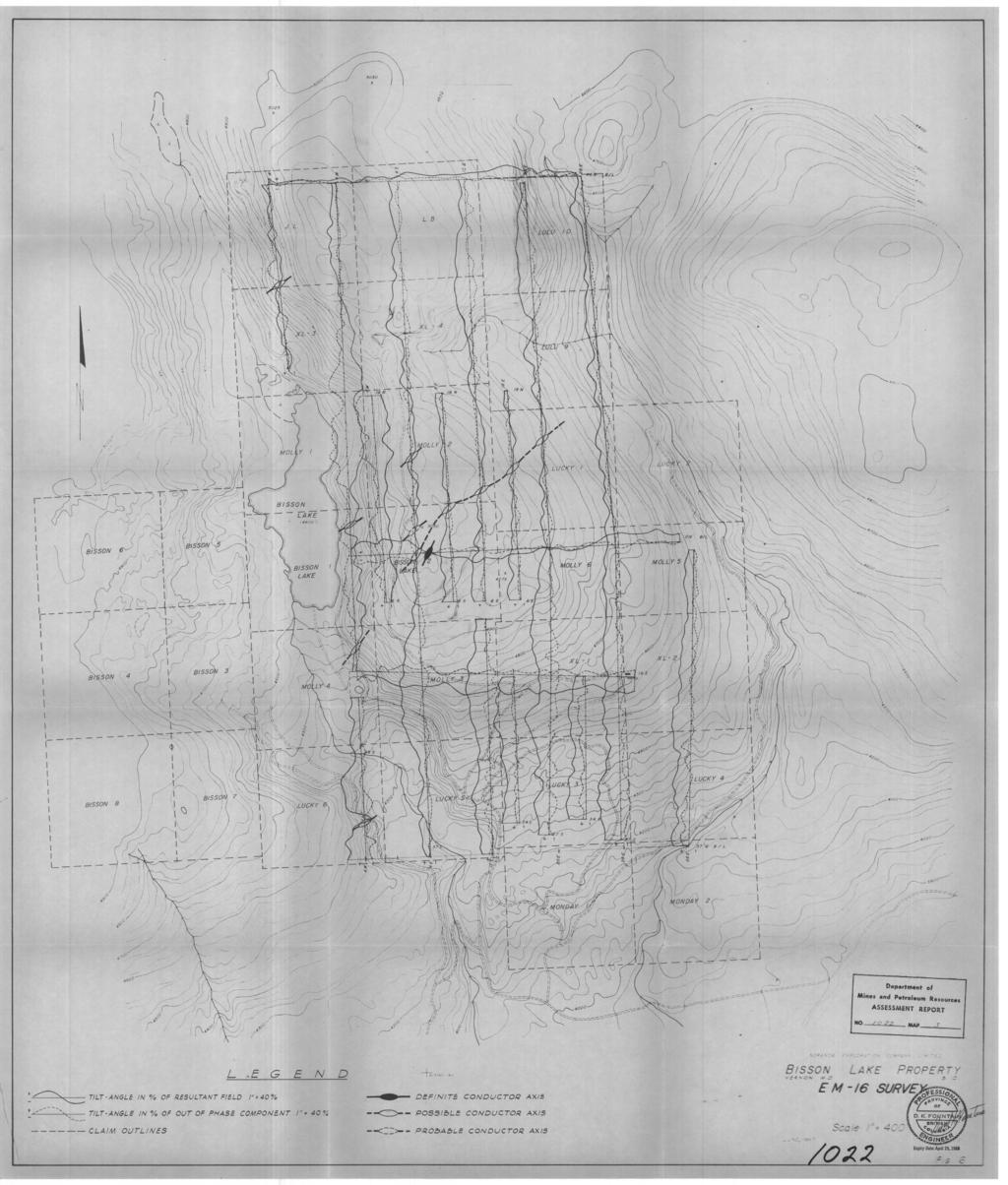
2 TABLE OF CONTKNTS INTBODUCTION Fig. vi {Loeation Map) " Fig. 42 (Claim Map) LINE PREPAUTION / +'z ELBCPBOMAaETIC SURVEY Method Presentation of Results Discus~ion of Results INDUCED POLARIZATION AND RESISTIVITY SURVEY Method Presentation of Results Fig. A - Mathod used in Plotting /Pig. 13 Data Plot Line 4U fig. #4 Data Plot Line 4E,/Pig. 45 Data Plot Line 129 Discussion of Results CONCLUSIONS AND ilbc0mlb)idations PIAN W S (IN POCKET) g 4 Fig. #6 E.M. -16 Survey f / Pig. 47 Induced Polukrcation urd Ruistivity Survey
3 REPORT ON THE ELBCZRO~WETIC AND INDUCED POLABIZATION AND RESISTIVITY SURVEYS OM THE BISSON LAgB PROPERTY WORAPIDA EXPLORATION COMPANY, LMITED INZaoDUCTION The Bisson Lake Property referred to in this report lies approximately thirty-three air-miles south 60' east from the City of Vernon, British Columbia. Access to the property is via PROVINCIAL HIGHWAY NUMBER 6 east from Vernon, south on the Kettle River Valley access road, and then by jeep road to the property. The property comprises twenty-eight contiguous mineral claims in the Vernon Mining Division optioned to Noranda Explora- tion Company, Limited (N.P.L.) by the owners John Lesowski, Albert Lesowski, Joseph Lesowski, William Miller and William McGie. In addition to the optioned claims and contiguous with them, two claims owned by Noranda Exploration Company, Limited (N.P.L.) are considered as forming part of the property. In particular. the claims are as follows: -
4 BISSON LAKE PROPERTY NORANDA EXPLORATION CO. LPD. LOCATION MAP VERNON M.D. SCALE: I": MI LESS
5 r--? NORANDA f LAlMS Mines and Petroleum Resource ASSESSMENT REPORT NO /C 2'2 MAP...??!. NORANDA EXPLORATION CO. LTD. CLAIM MAP BISSON LAKE PROPE VERNON M.D. SCALE : MILE Expiry Date: Aeril 2h June 1967
6 Optioned from John Lesowski, et a1 - Claim Bisson Lake No. Bisson Lake NO. Bisron No. 3 Bisson No. 4 Bisson No. 5 Bisson No. 6 Bisson No. 7 Bisson No. 8 J.L. L.B. Lucky No. 1 Lucky No. 2 Lucky No. 3 Lucky No. 4 Lucky No. 5 Lucky No. 6 Molly No. 1 Molly No. 2 Molly No. 3 Molly No. 4 Uolly No. 5 Molly No. 6 Monday No. 1 Monday No. 2 XL No. 1 XL No. 2 XL No. 3 XL No. 4 Record Number Owned by Noranda Exploration Company. LFaited (N.P.L.) - Claim Lulu No. 9 Lulu No. 10 Record Number The mineral claim8 comprising the property were staked on the basis of possible economic mineralisation uncovered during the preparation of a logging road. The geophysical surveys described in this report were carried out in an attempt to determine the amount and extent of this minrralized area as well as attempting to locate similar mineralized zones on other parts
7 - 3 - of the property. If the results of these surveys were favourable. then further investigation in the form of diamond drilling and/or trenching could be carried out to determine the economic signifi- cance of the mineralization. BASE MAP AND GRID LINE PREPARATION In order to carry out a geophysical survey. appropriate control must be established on the ground to properly locate the observations recorded. Initially, a topographic base map of the area was prepared at a scale of 1 inch equals 400 feet by HcElhanney Surveying and Engineering of Vancouver. This bane map, prepared from photo coverage of the area, outlinm roads, streams and topographic contours at twenty-five foot intervals. For the purpose of the Electromagnetic survey, three cut base lines were established, naaely 46N, ON, and 375 for a total of 12,000 feet of cut line. Utilizing these base lines, grid control consisted of blazed and flagged chain and compass lines, with stations established at 100 foot intervals along the line. A total of 67,800 feet of line was established in this way. One man, in addition to the Elactromagnetic instrument operator, was required for this work. For the purpose of the Induced Polarization and Resistivity Survey, cut and cleared picket lines were established at right angles to Base Line ON. Stations were established at 200 foot intervals
8 along these lines. A total of 16,000 feet of cut line was established in this way. A three man crew of linecutters utilizing axe and power saw were required to prepare and chain the base lines and the traverse lines for the Induced Polarization survey. E~CTROEUGNETIC SURVEY Method The electromagnetic survey on the property was carried out utilizing an E.H.-16 survey unit manufactured by Gconics Limited, Toronto. The serial number of the particular unit employed was No. 47. The theory and operation of this unit is described fully in the literature, but a brief outline will be given here. The E.H.-16 is simply a sensitive receiver covering the frequency band of the new VLP transmitting stations located throughout the world, and capable of measuring the vertical field components. Tha VLI transmitting stations have a vertical antenna creating a conontric horizontal magnetic field around them. When these magnetic fields meet conductive bodies in the ground, secondary fielgare set up which cause variations in the remultant field. By measuring the variations in the resultant field, it is possible to map the conduc- tive zones. It will be seen from the above that the method is similar to the standard Vertical Transmitting Loop system except that the transmitter is in effect located at infinity. ltm measurements are normally made, the tilt-angle in percentages from the horizontal of the resultant field and a
9 - 5 - compensation "12 signal from a second coil which is a measure of the out-phase component of the resultant field. To take a reading, the instrument is first aligned in the field by means of nulling. The tilt angle of the resultant field from the horizontal is measured by obtaining a null about the horizontal axis. At the same time, by nulling the quadrature dial. a measure of the out of phase component is obtained. For this particular survey, two stations were employed. For the east-west lines the station at Seattle. Washington (NPG. frequency 18.6 W) was utilized. The station at Cutler, Maine (NU, frequency 17.8 khz) was used for the north-south lines. A total of 67,800 feet of line was covered with readings being taken at 100 foot intervals. Presentation of Results The results of the survey are presented in Figure No. 6 of this report, a plan map at a scale of one inch equals 900 feet. The tilt-angle in percentage of the resultant field and the tilt angle in percentage of the out of phase component are plotted in the form of profiles along the line at a scale of one inch equals 40 percent. The conductor axes are indicated by appropriate symbols and arbitrarily graded as to definite, possible, and probable. The claim outlines are also indicated on the map. Discussion of Results The results of the E.M.-16 suwey indicated several weak, one-line conductors, as well as one longer zone. This zone extends
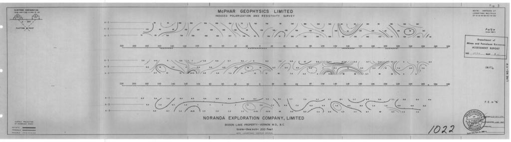
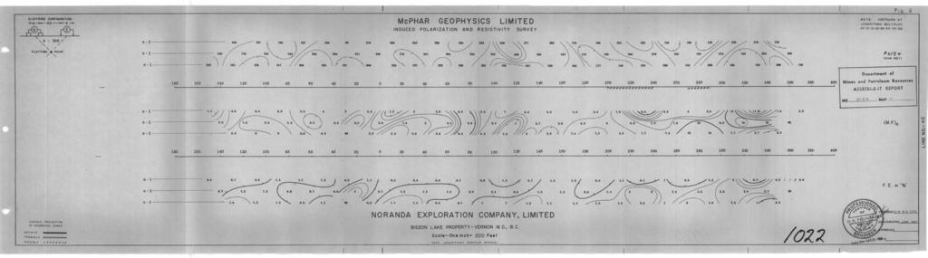
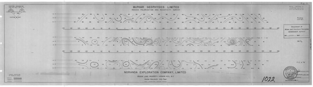
10 - 6 - from approximately ON on Line 4I1 to 13N on Line 2OB for an overall conductor axis strike length of at least 2400 feet. The weak conductive gone does not ippaar to be significant in itself. IWDUCKD POLARIZATION AH0 RESISTIVITY SURVEY Method The Induced Polariration and Resistivity Survey was carried out utilizing a McPhar Variable Frequency I.P. unit. The unit and operator were on contract from McPhar Geophysics Limited of Toronto. The theory and method of operation of the Variable Frequency Induced Polariration Method is fully described in the literature and will not be further described here. In this particular survey, a dipole-dipole electrode configuration was employed with 200 foot dipoles and reading three dipole separations. The frequencies eqloyed were and 5 cps. The survey crew comprised four men: the operator, the transmitter operator, and two assistants. Presentation of Results The induced polarization and resistivity results are shown on the enclosed data plots. In plotting theseresults, the values of the apparent resistivity, apparent metal factor, and apparent percent frequency effect meuured for aach set of electrode positions are plotted at the intersection of grid lines, one from the center point of the current electrodes and
11 METIiOD USED IN PLOTTIXG DIPOLSDLPOLE INDUCED POLARIZATION h\9 RESISTI'JITY RESULTS Stations on line x = Electrode spread length n = Electrode separation P P P n P P P P n Apparent Resistivity n - 2 P P P P P 1.2-4,s 2.3-5,6 3, n - 1 P P P P P P L I I 9 n M.F. M.F. M.F. M.F. M.F. n M.F. M.F. M.F. M.F n Apparent Metal Factor M.F. M.F. M.F. n F.E. F.E. F.E. F.E. F.E. n ,6-8.9
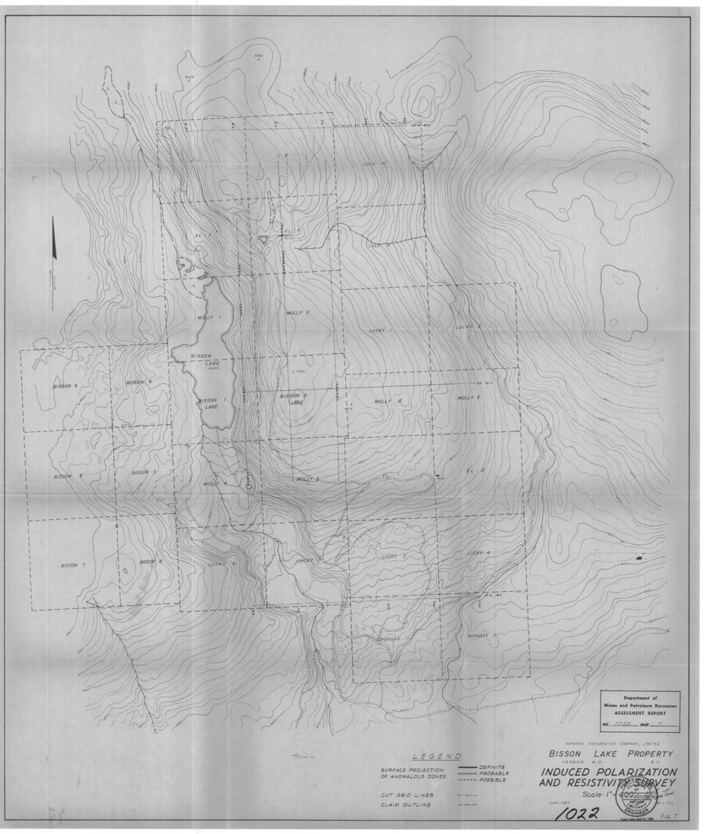
12 - 7 - the other from the center point of the potential electrodes. This is clear from the accompanying diagram. It should be mentioned here that the sectional plot doer not represent an electrical cross-section of the ground. The patterns developed from the observed readings can be interpreted by comparison with expected patterns obtained from computer programmes, model studies and previous experience. Both on the data plots and the plan map, the vertical projection of the I.P. anomalies are indicated by solid, dashed,or hatched liner depending upon their distinctiveneaa. The data plots for Line 4W, Line 4E, and Line 12E are presented in Figures 3. 4 and 5 respectively. Figure 7 is a plan map of the property at a scale of one inch equals 400 feet on which the vertical projection of the I.P. anomalies have been indicated. Discussion of Results Ueak I.P. response8 were obtained trom 145 to 16s on Line 4W, from IN to 2S on Line 12E, and from 1H to 2S on Line 4W. The latter would appear to correlate with the original mineralized shoving. In addition, two pax allel nor theas t trending weak responses are indicated at 12N to 16N and 18N to 22N on Line &OW, and 20N to 24N and 27N to 29N on Line 4+00B. These zones do not appear to extend to Line 12+00E, and the direction ot the I.P. trend agrees with the direction of possible structural trends in the area.
13 Weak anomalous responses have been obtained in both the Electromagnetic and Induced Polarfration Surveys. However, due to the weakness of these responses, further vork would not be warranted unless there was strong supporting geological or geochanical information. Respectfully suhitted Toronto, Ontar fo June 29, Expiry Date: April
14
15
16
17
18
Induced Polarization and Resistivity Survey. and. Electromagnetic Survey. on the MINERAL CIAIMS CARIROO MINTNG DIVTSION
 .. 37 ' i czi' "$6 Induced Polarization and Resistivity Survey and. V.L.F. Electromagnetic Survey on the Brenda 1-7, Mayday 1-6, 9-11, 14, 15, Ted 1-6, Maybe l-g, Tell 1-4, Anchor IA, 2B, 3, 4, Mayday
GEOPHYSICAL REPORT on the ZIP 1 MINERAL CLAIM ATLIN M.D.
 ., GEOPHYSICAL REPORT on the ZIP 1 MINERAL CLAIM ATLIN M.D. N.T.S. 1040/5E Long. 131 36' August 1-3 1980 Falconbridge Nickel Mines Limited. Vancouver, B. C. October, 1980 B. W. Downing. TABLE OF CONTENTS
REPORT ON GEOPHYSICAL WORK PERFORMED ON BRADETTE 1-73 BRADETTE TOWNSHIP LARDER LAKE MINING DIVISION BURNTBUSH RIVER AREA, ONTARIO
 32E12SE0056 2.1565 BRADETTE 010 SEP l i 1974 PROJECTS UNIT REPORT ON GEOPHYSICAL WORK PERFORMED ON BRADETTE 1-73 BRADETTE TOWNSHIP LARDER LAKE MINING DIVISION BURNTBUSH RIVER AREA, ONTARIO SEPTEMBER 3,
TULLY TOWNSHIP PROVINCE OF ONTARIO
 S 42A14S68152 63.2756 TOLLY 010 TEXMONT MINES LIMITED ELECTROMAGNETIC AND MAGNETOMETRIC SURVEYS TULLY TOWNSHIP PORCUPINE MINING DIVISION PROVINCE OF ONTARIO BY: C.F. DESSON March 1970 -3 - PROPERTY CLAIM
Here the goal is to find the location of the ore body, and then evaluate its size and depth.
 Geophysics 223 March 2009 D3 : Ground EM surveys over 2-D resistivity models D3.1 Tilt angle measurements In D2 we discussed approaches for mapping terrain conductivity. This is appropriate for many hydrogeology
OMINECA MINING DIVISION
 A GEOI'HYSICAL REPORT ON llfe NARY CLAIMS OMINECA MINING DIVISION TABLE OF CONTENTS Page INTRODUC TION LOCATION 1969 FROGBAN AIRBORNE SURrn EQUIPMENT, RESULTS SURVEY AND DATA REDUCTION COBCLUSIONS AKD
RHUMTY LAKE NTS 42D-14
 RHUMTY LAKE NTS 42D-14 z. ss?e LOWER AGUASABON LAKE 010 MINING LANDS SECTION INTJROpUCTION This report covers a VLF survey performed October 18 to October 28, 1976 on eleven (11) contiguous, unpatented
/fw MAP... ;... NO '...:... (In Pocket). Page. Introduction... Location and Accessibility... Purpose of the Induced Polarization Survey...
. Page. Introduction... Location and Accessibility... Purpose of the Induced Polarization Survey...") A GEOPHYSCAL REPORT ON AN NDUCED POLARZATON SURVEY MM EAST AND WEST GROUP SKEENA MNNG DVSON, BRTSH COLUMBA PROPERTY : MM EAST AND WEST CLAM GROUP LOCATON:, 9 MLES S.W. OF ANAHM 52O 250 S.E. REPORT BY:
A GEOPHYSCAL REPORT ON AN NDUCED POLARZATON SURVEY MM EAST AND WEST GROUP SKEENA MNNG DVSON, BRTSH COLUMBA PROPERTY : MM EAST AND WEST CLAM GROUP LOCATON:, 9 MLES S.W. OF ANAHM 52O 250 S.E. REPORT BY:
Elk Lake Mining Company Limited. VLF EM Survey Over the. Elk Lake Property. James Township, Ontario
 PO Box 219, 1579 Government Road, Larder Lake, Ontario, P0K 1L0, Canada Phone (705) 63-235 Fax (705) 63-2191 www.cxsltd.com Elk Lake Mining Company Limited VLF EM Survey Over the C Jason Ploeger, B.Sc,
REPORTONTHE ELECTROMAGNETIC SURVEY LV- PYCU- DEER LAKE AREA, LITTLE FORT, FOR BARRIER REEF RESOURCES LTD. (N. P. L. ) AND. MARION A. GOUDIE, B.Sc.
 AND. MARION A. GOUDIE, B.Sc.") w.a..s. NO....... MAP... vo V REPORTONTHE ELECTROMAGNETIC SURVEY LV- PYCU- DEER LAKE AREA, LITTLE FORT, KAMLOOPS MINING DIVISION, B. C. FOR BARRIER REEF RESOURCES LTD. (N. P. L. ) BY PHILIP G. HALLOF,
w.a..s. NO....... MAP... vo V REPORTONTHE ELECTROMAGNETIC SURVEY LV- PYCU- DEER LAKE AREA, LITTLE FORT, KAMLOOPS MINING DIVISION, B. C. FOR BARRIER REEF RESOURCES LTD. (N. P. L. ) BY PHILIP G. HALLOF,
nu... MAP. 1 NO. 1 I I I Department. of CONTENTS Page No. Introduction... Location and Accessibility... Purpose of the Induced Polarization Survey...
 A GEOPHYSCAL REPORT ON AN NDUCED POLARZATON SURVEY FRENDLY LAKE NOS., 2 and 3 CLAM GROUPS KAMLOOPS MNNG DVSON, BRTSH COLUMBA PROPERTY: FL EAST AND WEST CLAM GROUP LOCATON : 6 MLES NW OF LTTLE FORT, B.C.
/ OWNER(S) (' '<+j. me.claim. ...I 158.9swe11.Str.e.e.t...Vancouuez:.B..C... 1'6rS..K ; Powell Street
 (' '<+j. me.claim. ...I 158.9swe11.Str.e.e.t...Vancouuez:.B..C... 1'6rS..K ; Powell Street") ., 1986.. I................ (' '
., 1986.. I................ (' '
A COMPARISON OF ELECTRODE ARRAYS IN IP SURVEYING
 A COMPARISON OF ELECTRODE ARRAYS IN IP SURVEYING John S. Sumner Professor of Geophysics Laboratory of Geophysics and College of Mines University of Arizona Tucson, Arizona This paper is to be presented
Clinton Mining Division N.T.S. 92P/14W North Latitude 121'20 ' West Longitude
 . -.., ' NDUCED POLARZATON AND RESSTVTY SURVEY, E %'. P MNERAL CLAMS FLY - 32 Record Numbers 309 to 32, inclusive and 36 to 370, inclusive Clinton Mining Division ' 5'45' N.T.S. 92P/4W North Latitude 2'20
Electromagnetic Induction
 Electromagnetic Induction Recap the motivation for using geophysics We have problems to solve Slide 1 Finding resources Hydrocarbons Minerals Ground Water Geothermal Energy SEG Distinguished Lecture slide
VLF EM Survey Over the POWELL PROPERTY Powell Township, Ontario
 PO Box, 47 Government Road, Larder Lake, Ontario, PK L, Canada Phone (7) 44 Fax (7) 4 www.cxsltd.com VLF EM Survey Over the POWELL PROPERTY C Jason Ploeger, B.Sc, P.Geo May, TABLE OF CONTENTS. SURVEY DETAILS....
GOLD DIAMET RESOURCES LTD.
 Jason Ploeger 14579 Government Road Larder Lake, Ontario P0K 1L0, Canada Phone (705) 643-1122 Fax (705) 643-2191 GOLD DIAMET RESOURCES LTD. Magnetometer Surveys Over the A1 PROPERTY Arnold Township, Ontario
Statement of Qualifications
 Revised January 29, 2011 ClearView Geophysics Inc. 12 Twisted Oak Street Brampton, ON L6R 1T1 Canada Phone: (905) 458-1883 Fax: (905) 792-1884 general@geophysics.ca www.geophysics.ca 1 1. Introduction
I NDUCED POLAR I ZAT I ON AND RES I ST I V I TY
 I NDUCED POLAR I ZAT I ON AND RES I ST I V I TY SURVEY ON HE LEO M I - 25 NERAL NCLUS I VE CLAIMS 50 NORANDA EXPLORATION COMPANY, LIMITED NICOLA MINING DIVISION JUNE 5, 1973 to SEPTEMBER 29, 19'73... 1
Report of Activities Neil R. Maki ft Partners Exploration Program OMEP Designation
 010 Report of Activities Neil R. Maki ft Partners Exploration Program OMEP Designation 65.5134 As noted in my application for designation of an exploration program our claim group located in Vincent and
TECHNICAL NOTE EXTREMELY LOW FREQUENCY (ELF) EM SYSTEM
 EM SYSTEM") TECHNICAL NOTE 2012-01 EXTREMELY LOW FREQUENCY (ELF) EM SYSTEM Dave Hildes, Ph.D, P. Geol Aurora Geoscicences Ltd. 34A Laberge Road, Whitehorse, YT, Y1A 5Y9 techniques such as MT / CSAMT / large-loop TEM.
TECHNICAL NOTE 2012-01 EXTREMELY LOW FREQUENCY (ELF) EM SYSTEM Dave Hildes, Ph.D, P. Geol Aurora Geoscicences Ltd. 34A Laberge Road, Whitehorse, YT, Y1A 5Y9 techniques such as MT / CSAMT / large-loop TEM.
Electrical Resistivity Imaging
 Approved for Public Release; Distribution Unlimited Electrical Resistivity Imaging David Hull US Army Research Lab hull@arl.army.mil 17 Jun 2009 ARL Workshop on Personnel, Vehicle, and Tunnel Detection
LOGISTICS REPORT ON COMBINED HELICOPTER BORNE MAGNETIC, AND VLF-EM SURVEY HEIDI AND TEA AREAS BRITISH COLUMBIA FOR BP RESOURCES CANADA LIMITED RV
 z i i 58943 LOGSTCS REPORT ON COMBNED HELCOPTER BORNE MAGNETC, AND VLF-EM SURVEY HED AND TEA AREAS BRTSH COLUMBA FOR BP RESOURCES CANADA LMTED RV U AERODAT LMTED August 28, 989 rc E \ wv: QU d w Diana
HELICOPTER-BORNE GEOPHYSICAL SURVEY SYSTEMS
 HELICOPTER-BORNE GEOPHYSICAL SURVEY SYSTEMS APPLICATIONS: base & precious metals exploration diamondiferous kimberlite exploration geological mapping mapping of fault zones for engineering and mining applications
ENVI.2030L Topographic Maps and Profiles
 Name ENVI.2030L Topographic Maps and Profiles I. Introduction A map is a miniature representation of a portion of the earth's surface as it appears from above. The environmental scientist uses maps as
Geology 228/378 Environmental Geophysics Lecture 10. Electromagnetic Methods (EM) I And frequency EM (FEM)
 I And frequency EM (FEM)") Geology 228/378 Environmental Geophysics Lecture 10 Electromagnetic Methods (EM) I And frequency EM (FEM) Lecture Outline Introduction Principles Systems and Methods Case Histories Introduction Many EM
Geology 228/378 Environmental Geophysics Lecture 10 Electromagnetic Methods (EM) I And frequency EM (FEM) Lecture Outline Introduction Principles Systems and Methods Case Histories Introduction Many EM
Detection of Pipelines using Sub-Audio Magnetics (SAM)
") Gap Geophysics Australia Pty Ltd. Detection of Pipelines using Sub-Audio Magnetics is a patented technique developed by Gap Geophysics. The technique uses a fast sampling magnetometer to monitor magnetic
Gap Geophysics Australia Pty Ltd. Detection of Pipelines using Sub-Audio Magnetics is a patented technique developed by Gap Geophysics. The technique uses a fast sampling magnetometer to monitor magnetic
TEMAGAMI GOLD INC. Magnetometer and VLF EM. Surveys Over the SHERMAN PROPERTY. Strathy Township, Ontario
 PO Box, Government Road, Larder Lake, Ontario, PK L, Canada Phone () Fax () www.cxsltd.com Magnetometer and VLF EM Surveys Over the SHERMAN PROPERTY C Jason Ploeger, B.Sc, P.Geo October, TABLE OF CONTENTS.
Induced Polarization Survey Over the Rand Property Teck Township, Ontario
 PO Box 219, 14579 Government Road, Larder Lake, Ontario, P0K 1L0, Canada Phone (705) 643-2345 Fax (705) 643-2191 www.cxsltd.com Induced Polarization Survey Over the Teck Township, Ontario C. Jason Ploeger,
Stratagem EH4 Geometrics, Inc.
 Stratagem EH4 Geometrics, Inc. Stratagem EH4 Hybrid-Source Magnetotellurics Frequency range of 10 Hz to 90k Hz Approx. depth of investigation from 5m to 1km Portable with rapid setup and teardown Full
) LOG NO: 060L-l RD. gx ii. ..,d &m RECEIVED UTEM SURVEY JW 1-10 CLAIMS. FOR KINGDOM RESOURCES LTD. < s,
 LOG NO: 060L-l RD. gx ii. ..,d &m RECEIVED UTEM SURVEY JW 1-10 CLAIMS. FOR KINGDOM RESOURCES LTD. < s,") ) LOG NO: 060L-l RD. I UTEM SURVEY JW 1-10 CLAIMS FOR KINGDOM RESOURCES LTD. < s, gx ii RECEIVED J*V* CONSULTANTS LTD. and MONTAGNE GEOPHYSICS LTDC,'+! ; f$!fi. #..".---- $ --------------, 0 1 v~'fincp~!bfe'!,
) LOG NO: 060L-l RD. I UTEM SURVEY JW 1-10 CLAIMS FOR KINGDOM RESOURCES LTD. < s, gx ii RECEIVED J*V* CONSULTANTS LTD. and MONTAGNE GEOPHYSICS LTDC,'+! ; f$!fi. #..".---- $ --------------, 0 1 v~'fincp~!bfe'!,
Magnetometer and VLF EM Surveys Over the
 PO Box 9, 4579 Government Road, Larder Lake, Ontario, PK L, Canada Phone (75) 645 Fax (75) 64-9 www.explorationservices.ca Magnetometer and VLF EM Surveys Over the ANVIL PROPERTY Van Nostrand Township,
Photocrametric Surveying >Iount Sanford Ares, for. Canadian Johns-:r:anville Co. Ltd. Box i500, As3estos, aue.
 Photocrametric Surveying >Iount Sanford Ares, for Canadian Johns-:r:anville Co. Ltd. Box i500, As3estos, aue. Table of Contents Introduction Page 1 Reason for the Photogranimetric Survey Scope of the
S u r v e y i n g f o r M i n i n g E n g i n e e r i n g ( 1 1 B ) 30S/30E/30M
 30S/30E/30M") 9 1 4 9 S u r v e y i n g f o r M i n i n g E n g i n e e r i n g ( 1 1 B ) 30S/30E/30M 9 1 4 9 S u r v e y i n g f o r M i n i n g E n g i n e e r i n g ( 1 1 B ) 3 0 S / 3 0 E / 3 0 M Course Description
9 1 4 9 S u r v e y i n g f o r M i n i n g E n g i n e e r i n g ( 1 1 B ) 30S/30E/30M 9 1 4 9 S u r v e y i n g f o r M i n i n g E n g i n e e r i n g ( 1 1 B ) 3 0 S / 3 0 E / 3 0 M Course Description
GEOPHYSICAL ASSESSMENT REPORT on the SKIDOO PROPERTY, NATION RIVER PROJECT CCOMBINED HELICOPTER-BORNE MAGNETIC AND VLF SURVEY) FORT FRASER.
 FORT FRASER.") GEOPHYSICAL ASSESSMENT REPORT on the SKIDOO PROPERTY, NATION RIVER PROJECT CCOMBINED HELICOPTER-BORNE MAGNETIC AND VLF SURVEY) FORT FRASER. BC October 19, 1990, AERODAT REPORT ON COMBINED HELICOlTER-BORNE
GEOPHYSICAL ASSESSMENT REPORT on the SKIDOO PROPERTY, NATION RIVER PROJECT CCOMBINED HELICOPTER-BORNE MAGNETIC AND VLF SURVEY) FORT FRASER. BC October 19, 1990, AERODAT REPORT ON COMBINED HELICOlTER-BORNE
AMADOR GOLD CORP. GPS, Magnetometer and VLF EM Surveys Over the. AJAX PROPERTY Strathy Township, Ontario
 PO Box Government Road Larder Lake, Ontario PK L, Canada Phone () - Fax () - AMADOR GOLD CORP. GPS, Magnetometer and VLF EM Surveys Over the AJAX PROPERTY Strathy Township, Ontario TABLE OF CONTENTS. SURVEY
Automated anomaly picking from broadband electromagnetic data in an unexploded ordnance (UXO) survey
 survey") GEOPHYSICS, VOL. 68, NO. 6 (NOVEMBER-DECEMBER 2003); P. 1870 1876, 10 FIGS., 1 TABLE. 10.1190/1.1635039 Automated anomaly picking from broadband electromagnetic data in an unexploded ordnance (UXO) survey
GEOPHYSICS, VOL. 68, NO. 6 (NOVEMBER-DECEMBER 2003); P. 1870 1876, 10 FIGS., 1 TABLE. 10.1190/1.1635039 Automated anomaly picking from broadband electromagnetic data in an unexploded ordnance (UXO) survey
A Method of Mapping Resistive or Conductive offshore Targets also an Apparatus for Applying the Method
 A Method of Mapping Resistive or Conductive offshore Targets also an Apparatus for Applying the Method BACKGROUND OF THE INVENTION 1. Field of the Invention The present invention is related to a method
Sferic signals for lightning sourced electromagnetic surveys
 Sferic signals for lightning sourced electromagnetic surveys Lachlan Hennessy* RMIT University hennessylachlan@gmail.com James Macnae RMIT University *presenting author SUMMARY Lightning strikes generate
A Report on the Ground Penetrating Radar Survey 205 Little Plains Road Southampton, NY
 A Report on the Ground Penetrating Radar Survey 205 Little Plains Road Southampton, NY November 18, 2016 Conducted by Robert W. Perry TOPOGRAPHIX, LLC Hudson, NH Requested by Southampton Town Historical
Introduction to Aerial Photographs and Topographic maps (Chapter 3)
") GEOLOGY 306 Laboratory Instructor: TERRY J. BOROUGHS NAME: Introduction to Aerial Photographs and Topographic maps (Chapter 3) For this assignment you will require: a calculator and metric ruler. Objectives:
GEOLOGY 306 Laboratory Instructor: TERRY J. BOROUGHS NAME: Introduction to Aerial Photographs and Topographic maps (Chapter 3) For this assignment you will require: a calculator and metric ruler. Objectives:
KARIN BALZER Magnetometer Survey Over the PACAUD CLAIM Pacaud Township, Ontario
 PO Box 219 179 Government Road Larder Lake, Ontario PK 1L, Canada Phone (7) -1122 Fax (7) -2191 KARIN BALZER Magnetometer Survey Over the Pacaud Township, Ontario TABLE OF CONTENTS 1. SURVEY DETAILS...
We are committed to providing accessible customer service. If you need accessible formats or communications supports, please contact us.
 We are committed to providing accessible customer service. If you need accessible formats or communications supports, please contact us. Nous tenons à améliorer l accessibilité des services à la clientèle.
STANDARD OPERATING PROCEDURES SOP:: 2057 PAGE: 1 of 6 REV: 0.0 DATE: 07/11/03
 PAGE: 1 of 6 1.0 SCOPE AND APPLICATION 2.0 METHOD SUMMARY CONTENTS 3.0 SAMPLE PRESERVATION, CONTAINERS, HANDLING, AND STORAGE 4.0 INTERFERENCES AND POTENTIAL PROBLEMS 5.0 EQUIPMENT/APPARATUS 6.0 REAGENTS
STATE UNIVERSITY CONSTRUCTION FUND
 DIRECTIVE 1C-12 Issue date: August 2012 1. General SURVEY, MAPPING AND UTILITY LOCATING This Directive has been developed as a general guide for the survey and mapping effort required for Fund projects.
'I. 1 I I I I VANCOUVER,B.C. Gold Commissioner's Office. Garv C. Lee, P.Ena. April Atlin Wining Division, B.C. Latitude 59O51', Longitude 133%1*
 Gold Commissioner's Office VANCOUVER,B.C. GEOPHYSCAL SURVEY by Garv C. Lee, P.Ena. April 996 OLD'PHBR -4 PLACER CLAMS (39799, 33398-333200) and JEU and 2 MNERAL CLAMS (342695, 342696) Atlin Wining Division,
Electronic Pipeline Technology
 Pipe and Cable Locator Pearson Holiday Detector Model EPT- 1000 Electronic Pipeline Technology Electronic Pipeline Technology 26 Palomino Drive, Richmond Hill, Ontario, Canada, L4C 0P8 Tel: (905) 918-0025
BURIED LANDFILL DELINEATION WITH INDUCED POLARIZATION: PROGRESS AND PROBLEMS* Abstract. Introduction
 BURIED LANDFILL DELINEATION WITH INDUCED POLARIZATION: PROGRESS AND PROBLEMS* Norman R. Carlson, Jennifer L. Hare, and Kenneth L. Zonge Zonge Engineering & Research Organization, Inc., Tucson, AZ *In Proceedings
Surveying & Measurement. Detail Survey Topographic Surveying
 Surveying & Measurement Detail Survey Topographic Surveying Introduction Mapping surveys are made to determine the relief of the earth s surface and locate critical points on it. to determine the locations
Antenna Design Seminar
 Antenna Design Seminar What we are going to cover This seminar will cover the design concepts of a variety of broadcast antennas that relates to the design of TV and FM antennas. We will first look at
Old & New? INTRODUCTION. The Best Proximal Geophysical Detector Ever!
 Measuring Soil Conductivity with Geonics Limited Electromagnetic Geophysical Instrumentation INTRODUCTION This presentation will briefly discuss the principles of operation and the practical applications
DATE OF WORK: 30 Nay - 21 June! 1958
 A GEOPHYSICAL REPORT Oh AN IPIIWCEU PULAilIZATION SURVEY.JM #.I CLAIM GHOUl OSOYOOS MINING DIVISION RitITISFI COLU?1BIA PROPERTY : J?1 #I CLAIM GIIOUL LOCATX 0% : 6 ~ILES~X W. OF m u m Y R.C. 49 1.20 SE
Lesson 10. Unit 2. Reading Maps. Graphing Points on the Coordinate Plane
 Lesson Graphing Points on the Coordinate Plane Reading Maps In the middle ages a system was developed to find the location of specific places on the Earth s surface. The system is a grid that covers the
Cassiar'Mountain'Properties' Canada'Rockies'International'Investment'Group'Ltd.'
 Assessment'Report' Cassiar'Mountain'Properties' Liard'Mining'Division,'British'Columbia' ' Claims:' 898429,'898449,'898469B898473,'898475B898479' (Block'1' and' 895333B895334'and'895336B895345' (Block'2'
Getting Started with Induced Polarization
 Getting Started with Induced Polarization The Induced Polarization How-To Guides walk you through tasks you perform in the Induced Polarization TM (IP) system. The procedures are divided into common procedures
GEOPHYSICAL REPORT 0" REFRACTION SURVEY. BEAR, BEAVER 8 MOOSE CLAIMS 4 MILES N.N.E. OF MILE 548, ALASKA HIGHWAY 59O 127',NrW?$JADRANT /V' t.
 I 767,. I GEOPHYSICAL REPORT 0" REFRACTION SURVEY 0 BEAR, BEAVER 8 MOOSE CLAIMS 4 MILES N.N.E. OF MILE 548, ALASKA HIGHWAY 59O 127',NrW?$JADRANT /V' t.y. H. C. BICKEL, B. SC., P. Eng. for MAGNET COVE BARIUM
47 CFR Ch. I ( Edition)
") 73.684 should decrease more rapidly with distance beyond the horizon than for Channels 2 6, and modification of the curves for Channels 14 69 may be expected as a result of measurements to be made at a
73.684 should decrease more rapidly with distance beyond the horizon than for Channels 2 6, and modification of the curves for Channels 14 69 may be expected as a result of measurements to be made at a
CHAPTER 5 CONCEPTS OF ALTERNATING CURRENT
 CHAPTER 5 CONCEPTS OF ALTERNATING CURRENT INTRODUCTION Thus far this text has dealt with direct current (DC); that is, current that does not change direction. However, a coil rotating in a magnetic field
High Grade Gold, Copper, Lead and Zinc samples at Liberty - Indee Project
 ABN 28 122 180 205 www.juttholdings.com ASX ANNOUNCEMENT (ASX Code: JUT) 13 September 2007 High Grade Gold, Copper, Lead and Zinc samples at Liberty - Indee Project Highlights 32.5% Copper, 50.6 g/t Gold
P Forsmark site investigation. RAMAC and BIPS logging in borehole HFM11 and HFM12
 P-04-39 Forsmark site investigation RAMAC and BIPS logging in borehole HFM11 and HFM12 Jaana Gustafsson, Christer Gustafsson Malå Geoscience AB/RAYCON March 2004 Svensk Kärnbränslehantering AB Swedish
Introduction to Aerial Photographs and Topographic maps (Chapter 7, 9 th edition) or (chapter 3, 8 th edition)
 or (chapter 3, 8 th edition)") GEOLOGY 306 Laboratory Instructor: TERRY J. BOROUGHS NAME: Introduction to Aerial Photographs and Topographic maps (Chapter 7, 9 th edition) or (chapter 3, 8 th edition) For this assignment you will require:
GEOLOGY 306 Laboratory Instructor: TERRY J. BOROUGHS NAME: Introduction to Aerial Photographs and Topographic maps (Chapter 7, 9 th edition) or (chapter 3, 8 th edition) For this assignment you will require:
' f: (To Accompany Maps 68-16M, 68-16E) April 2nd, KENNCO EXPLORATIONS (CANADA^ LIMITED GRANT TOWNSHIP, ONTARIO.
 April 2nd, KENNCO EXPLORATIONS (CANADA^ LIMITED GRANT TOWNSHIP, ONTARIO.") ' ' f: 31L12SW***! Mt*AI FIBJ5 010 MAGNETOMETER AND ELECTROMAGNETIC SURVEY for KENNCO EXPLORATIONS (CANADA^ LIMITED GRANT TOWNSHIP, ONTARIO. (To Accompany Maps 68-16M, 68-16E) April 2nd, 1968. s-; f :.
' ' f: 31L12SW***! Mt*AI FIBJ5 010 MAGNETOMETER AND ELECTROMAGNETIC SURVEY for KENNCO EXPLORATIONS (CANADA^ LIMITED GRANT TOWNSHIP, ONTARIO. (To Accompany Maps 68-16M, 68-16E) April 2nd, 1968. s-; f :.
Suveying Lectures for CE 498
 Suveying Lectures for CE 498 SURVEYING CLASSIFICATIONS Surveying work can be classified as follows: 1- Preliminary Surveying In this surveying the detailed data are collected by determining its locations
2015 Geophysics Field School Virden Saline Contamination Project: May 5-7 (field work)
") 2015 Geophysics Field School Virden Saline Contamination Project: May 5-7 (field work) 1) Goals Township 11 The area around Virden, Manitoba is the oil-producing region of Manitoba. The oil is produced
2015 Geophysics Field School Virden Saline Contamination Project: May 5-7 (field work) 1) Goals Township 11 The area around Virden, Manitoba is the oil-producing region of Manitoba. The oil is produced
We are committed to providing accessible customer service. If you need accessible formats or communications supports, please contact us.
 We are committed to providing accessible customer service. If you need accessible formats or communications supports, please contact us. Nous tenons à améliorer l accessibilité des services à la clientèle.
INVERSION OF EM DATA TO RECOVER 1-D CONDUCTIVITY AND A GEOMETRIC SURVEY PARAMETER. Sean Eugene Walker
 INVERSION OF EM DATA TO RECOVER 1-D CONDUCTIVITY AND A GEOMETRIC SURVEY PARAMETER By Sean Eugene Walker B. Sc. (Honours), Geology & Physics, McMaster University, 1996 a thesis submitted in partial fulfillment
A. G. N. SYNDICATE. t, i REPORT ON A GEOPHYSICAL SURVEY
 - A. G. N. SYNDICATE TCLCPHONC 302-27(1 ARIA CODS 41* ' KIPftCSCNTiNQ ANCLO U*IHD OfVf COMtNT COMOKATION IIHITID ORTVRUN a (Ml HMITfO IIORWATC txptoration ItMITIO t, i SUIT! 1906 7 KINO STRICT CAST TORONTO
SURVEYING I CENG 383
 SURVEYING I CENG 383 9/21/2011 2 Introduction Definition An art of collecting data for mapping the relative positions of points above, below or on the surface of the earth. Surveying also includes the
Beepmat Survey Over the HUDSON BAY PROPERTY Leith Township, Ontario
 PO Box 219, 14579 Government Road, Larder Lake, Ontario, P0K 1L0, Canada Phone (705) 643-2345 Fax (705) 643-2191 www.cxsltd.com Beepmat Survey Over the HUDSON BAY PROPERTY C Jason Ploeger, B.Sc, P.Geo
CHECKLIST PRELIMINARY SUBDIVISION AND PRELIMINARY SITE PLAN
 N/A Waiver (1) Four (4) copies of application form. (2) Fifteen (15) copies of plan (3) Subdivision/site plan application fee & professional review escrow deposit (4) Variance application fee & professional
ASHLEY GOLD MINES LIMITED. Induced Polarization Survey Over the. ROW LAKE PROPERTY GRID Katrine Township, Ontario
 PO Box 219 14579 Government Road Larder Lake, Ontario P0K 1L0, Canada Phone (705) 643-1122 Fax (705) 643-2191 ASHLEY GOLD MINES LIMITED Induced Polarization Survey Over the ROW LAKE PROPERTY GRID Katrine
Lab #4 Topographic Maps and Aerial Photographs
 Lab #4 Topographic Maps and Aerial Photographs Purpose To familiarize you with using topographic maps. Visualizing the shape of landforms from topographic maps is an essential skill in geology. Proficiency
clarify the roles of the Department and minerals industry in consultation; and
 Procedures for Crown Consultation with Aboriginal Communities on Mineral Exploration Mineral Resources Division, Manitoba Science, Technology, Energy and Mines The Government of Manitoba recognizes it
360 inches (915 cm) 240 inches (610 cm) 120 inches (305 cm) 240 inches is the recommended pole length, 360 inches is the recommended free space area
 240 inches (610 cm) 120 inches (305 cm) 240 inches is the recommended pole length, 360 inches is the recommended free space area") FML C/P FM Antenna Right hand C/P Polarization Low wind load area Up to 1 kw Rating per bay Omni-directional Up to 8 kw input per array with power divider options The FML series of antennas are narrow
FML C/P FM Antenna Right hand C/P Polarization Low wind load area Up to 1 kw Rating per bay Omni-directional Up to 8 kw input per array with power divider options The FML series of antennas are narrow
Gold and Silver Exploration in Peru, March 2018
 Gold and Silver Exploration in Peru, March 2018 TSX.V: RYO www.riosilverinc.com Forward Looking Statements Certain information presented, including discussions of future plans and operations, contains
Lesson 8: Surveying the Forest
 Lesson 8: Surveying the Forest TEACHER: SCHOOL: GRADE LEVEL: 9-12 TASKS/COMPETENCIES ANR8046.172 Set up and operate a transit level and rod. ANR8046.173 Read a rod and a level to calculate slope. ANR8046.174
GOLD DIAMET RESOURCES LTD.
 CJP Exploration Inc. Larder Lake, Ontario P0K1L0 GOLD DIAMET RESOURCES LTD. Beepmat Survey Over the CABO PROPERTY TABLE OF CONTENTS 1. SURVEY DETAILS... 3 1.1 PROJECT NAME... 3 1.2 CLIENT... 3 1.3 LOCATION...
We 21P1 10 Spectral Time Domain IP - Factors Affecting Data Information Content and Applicability to Geological Characterization
 We 21P1 10 Spectral Time Domain IP - Factors Affecting Data Information Content and Applicability to Geological Characterization A. Rezvani* (Lund University), T. Dahlin (Lund University), P.I. Olsson
Dartmouth College LF-HF Receiver May 10, 1996
 AGO Field Manual Dartmouth College LF-HF Receiver May 10, 1996 1 Introduction Many studies of radiowave propagation have been performed in the LF/MF/HF radio bands, but relatively few systematic surveys
DISTORTION OF VLF RADIO WAVE FIELD VERTICAL METAL POLES.
 Title DISTORTION OF VLF RADIO WAVE FIELD VERTICAL METAL POLES Author(s) KIKUCHI, Takashi; ARAKI, Tohru Citation Contributions of the Geophysical In (1972), 12: 1-5 Issue Date 1972-12 URL http://hdl.handle.net/2433/178624
Lab #8: Topographic Map Lab
 NAME: LAB TIME: TA NAME: Lab #8: Topographic Map Lab Topography is the shape of the land. Topographic maps are used to aid in the visualization of the shape of the land. Topographic maps include the accurate
Topographic Maps. Contour Lines
 Topographic Maps Our first task today will consist of locating ourselves with the help of a topographic map. GPS units that can tell you the location of any Dunkin' Donuts within a five mile radius. Paper
COMAPARISON OF SURVEY RESULTS FROM EM-61 AND BEEP MAT FOR UXO IN BASALTIC TERRAIN. Abstract
 COMAPARISON OF SURVEY RESULTS FROM EM-61 AND BEEP MAT FOR UXO IN BASALTIC TERRAIN Les P. Beard, Battelle-Oak Ridge, Oak Ridge, TN Jacob Sheehan, Battelle-Oak Ridge William E. Doll, Battelle-Oak Ridge Pierre
Optimizing TV Transmitting Antennas for ATSC-M/H Mobile TV
 Optimizing TV Transmitting Antennas for ATSC-M/H Mobile TV By: Bill Ammons B i l l An under the Radome look at antenna design to optimize ATSC- We will take a look at: M/H transmission Azimuth Pattern
Earth Sciences 089G Short Practical Assignment #4 Working in Three Dimensions
 Earth Sciences 089G Short Practical Assignment #4 Working in Three Dimensions Introduction Maps are 2-D representations of 3-D features, the developers of topographic maps needed to devise a method for
Technical Note TN-30 WHY DOESN'T GEONICS LIMITED BUILD A MULTI-FREQUENCY EM31 OR EM38? J.D. McNeill
 Tel: (905) 670-9580 Fax: (905) 670-9204 GEONICS LIMITED E-mail:geonics@geonics.com 1745 Meyerside Dr. Unit 8 Mississauaga, Ontario Canada L5T 1C6 URL:http://www.geonics.com Technical Note TN-30 WHY DOESN'T
Report. Mearns Consulting LLC. Former Gas Station 237 E. Las Tunas Drive San Gabriel, California Project # E
 Mearns Consulting LLC Report Former Gas Station 237 E. Las Tunas Drive San Gabriel, California Project #1705261E Charles Carter California Professional Geophysicist 20434 Corisco Street Chatsworth, CA
CONTOURS SURVEYING 1 CE 215 CHAPTER -3- Ishik University / Sulaimani Civil Engineering Department 12/7/2017. Ishik University / Sulaimani
 Civil Engineering Department SURVEYING 1 CE 215 CHAPTER -3- CONTOURS 1 2 1 3 4 2 PURPOSE OF CONTOURING Contour survey is carried out at the starting of any engineering project such as a road, a railway,
TABLETOP MODELS FOR ELECTRICAL AND ELECTROMAGNETIC GEOPHYSICS
 TABLETOP MODELS FOR ELECTRICAL AND ELECTROMAGNETIC GEOPHYSICS Charles T. Young Department of Geological Engineering and Sciences, Michigan Technological University, Houghton, MI 49931, (906) 487-2072,
"Natural" Antennas. Mr. Robert Marcus, PE, NCE Dr. Bruce C. Gabrielson, NCE. Security Engineering Services, Inc. PO Box 550 Chesapeake Beach, MD 20732
 Published and presented: AFCEA TEMPEST Training Course, Burke, VA, 1992 Introduction "Natural" Antennas Mr. Robert Marcus, PE, NCE Dr. Bruce C. Gabrielson, NCE Security Engineering Services, Inc. PO Box
PART XIII: HYDRAULIC/ HYDROLOGY SURVEYS
 PART XIII: HYDRAULIC/ HYDROLOGY SURVEYS 13.1 Purpose and Scope Hydraulic surveys are required for flow analysis to determine bridge and culvert design characteristics. A hydraulic survey is usually but
6 Radio and RF. 6.1 Introduction. Wavelength (m) Frequency (Hz) Unit 6: RF and Antennas 1. Radio waves. X-rays. Microwaves. Light
 Frequency (Hz) Unit 6: RF and Antennas 1. Radio waves. X-rays. Microwaves. Light") 6 Radio and RF Ref: http://www.asecuritysite.com/wireless/wireless06 6.1 Introduction The electromagnetic (EM) spectrum contains a wide range of electromagnetic waves, from radio waves up to X-rays (as
6 Radio and RF Ref: http://www.asecuritysite.com/wireless/wireless06 6.1 Introduction The electromagnetic (EM) spectrum contains a wide range of electromagnetic waves, from radio waves up to X-rays (as
Geophysical Survey Rock Hill Bleachery TBA Site Rock Hill, South Carolina EP-W EPA, START 3, Region 4 TABLE OF CONTENTS Section Page Signature
 Geophysical Survey Rock Hill Bleachery TBA Site Rock Hill, South Carolina EP-W-05-054 EPA, START 3, Region 4 Prepared for: Tetra Tech EM, Inc. October 12, 2012 Geophysical Survey Rock Hill Bleachery TBA
Department of Civil and Environmental Engineering
 Department of Civil and Environmental Engineering CEE213L Surveying & Introduction to GIS Lab SURVEYING LABORATORY NORTH SOUTH UNIVERSITY Center of Excellence in Higher Education The First Private University
UNIT Explain the radiation from two-wire. Ans: Radiation from Two wire
 UNIT 1 1. Explain the radiation from two-wire. Radiation from Two wire Figure1.1.1 shows a voltage source connected two-wire transmission line which is further connected to an antenna. An electric field
Electromagnetic investigations by the VLF method of the ore bearing veins in the Hornsund Fiord area
 POLISH POLAR RESEARCH IPOL. POLAR RES.) POLSKIE BADANIA POLARNE U I 349 Г'56 1985 1 1 1 Janusz ANTONIUK Institute of Geophysics. Technical University of Mining and Metallurgy Mickiewicza 30. 30-059 Kraków
Hours / 100 Marks Seat No.
 17419 21415 3 Hours / 100 Seat No. Instructions (1) All Questions are Compulsory. (2) Answer each next main Question on a new page. (3) Illustrate your answers with neat sketches wherever necessary. (4)
Locating good conductors by using the B-field integrated from partial db/dt waveforms of timedomain
 Locating good conductors by using the integrated from partial waveforms of timedomain EM systems Haoping Huang, Geo-EM, LLC Summary An approach for computing the from time-domain data measured by an induction
HUDSON'S BAY OIL AND GAS COMPANY LIMITED REPORT ON MAGNETOMETER SURVEY SYLVIA CLAIMS by. G.I. Hall. October 8, 1975
 HUDSON'S BAY OL AND GAS COMPANY LMTED REPORT ON MAGNETOMETER SURVEY SYLVA CLAMS by G.. Hall October 8, 1975 CLAMS: LOCATON : DATES : OWNER: SYLVA Claims 16-18,20, 22, 24, 26, 29, 30, 33-36 OMNECA MNNG
SECTION CHAIN LINK FENCING AND GATES AND SOFTBALL BACKSTOP
 1 1 1 0 1 0 1 0 1 SECTION 1 1 CHAIN LINK FENCING AND GATES AND SOFTBALL BACKSTOP BASED ON DFD MASTER SPECIFICATION DATED /01/ P A R T 1 - G E N E R A L SCOPE The work under this section shall consist of