Grundlagen Fernerkundung - 8 Earth Resource Satellites
|
|
|
- Ethelbert Hall
- 6 years ago
- Views:
Transcription


1 Grundlagen Fernerkundung - 8 Earth Resource Satellites GEO123.1, FS2015 Hendrik Wulf, Michael Schaepman 3/30/15 Page 1


 3/30/15")
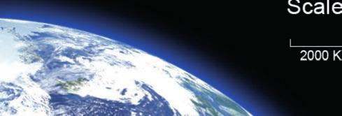
2 Earth Resource Satellites Remote sensing from space Application in science, government and industry Readily available (internet) Supports decision making based on spatial intelligence Conceiving the earth as a system (interaction of processes) Assessing the impacts of humankind on earth (resources) 3/30/15 Page 2 NASA
3 Learning Goals Overview on Earth Observation systems Understanding of satellite orbital parameters Understanding of sensor characteristics and trade-offs NASA Earth Observation Program o! e.g., Landsat, TERRA,! ESA Earth Observation Program o! e.g., Envisat, Earth Explorers,! 3/30/15 Page 3

 MODIS (http://modis.gsfc.nasa.gov/) Orbit tracking apps (pxsat, ESA wis, P-track, Sputnik)")
4 Recommended reading & surfing Lillesand, Kiefer and Chipman (2015): Remote Sensing and Image Interpretation, 7 th Edition, John Wiley & Sons. Chapter 5: Earth Resource Satellites, p Weblinks: Earth Observatory ( NASA ( Landsat ( MODIS ( Orbit tracking apps (pxsat, ESA wis, P-track, Sputnik)
5 Terms & Definitions: Orbits Inclination: orbit angle with respect to the equator near polar orbit = close to 90 equatorial orbit = 0!"#$#%&'!"!"#$!%&'()*"&%!"&"'+%!&,-+.'/"& #$%&'(')%*(+,"%+-)'!".(/"012333"45" &6*7&,*.8+%*%6&!"9337:33"45" (')$*&!"%#0"&%)&/)012"%"&)3"&)+(#%&45 ) 6& ;(*<&('!"=3>"45?"@:/@"5)*A%+-)'?"B9/>"+$C%D6')%*&"E$+"<(," FGG!"933"45?"@H/:"5)*A%+-)'?"B>/9"+$C%D6')%*&"E$+"<(," +,%-#*)$-"./)*00$12.#$3'!" #$*$+(DD,"-$'I$$*"B3"(5"(*<"H"E5 3/30/15 Page 5


6 Satellite Orbits 3/30/15 Page 6


7 Department of Geography Page 7


8 Orbiting Schemes Sun synchronous (polar) orbit Altitudes: 700 to 800 km Orbital periods: ca. 100 min Geostationary orbit Altitude: km High temporal resolution 3/30/15 Page 8


9 NASA Department of Geography Sun-synchronous (polar) Orbit


10 Geo-synchronous or Geostationary Orbit 3/30/15 Page 10
11 Terms & Definitions: Sensor characteristics Spatial resolution: ground surface area represented by one pixel Ground sampling distance (GSD) Field of view (FOV) and swath width GSD GSD 3/30/15 = 18 m Page 11 = 30 m
12 Terms & Definitions: Sensor characteristics Spatial resolution: ground surface area represented by one pixel Instantaneous field of view (IFOV) Ground sampling distance (GSD) Temporal resolution: time between two image acquisitions for a given location Revisit time or repeat cycle (measured in days) Spectral resolution: number of spectral bands and their wavelength intervals Panchromatic, multispectral, imaging spectroscopy Radiometric resolution: effective bit-depth of the sensor Gain settings: range of brightness sensitivity Signal to noise ratio 3/30/15 Page 12

13 Trade offs: Spatial and temporal resolution 3/30/15 Page 13

14 Trade offs: Spatial and spectral resolution Spectral bands of very high-resolution satellite imagery Pan = 0.6 m Multi = 2.4 m Pan = 0.5 m Pan = 0.5 m Multi = 2.0 m 3/30/15 Page 14
15 Across track scanner (Whisk broom) 3/30/15 Page 15
16 Along track scanner (Pushbroom) 3/30/15 Page 16
17 Passive optical sensor types Across track scanner (Whisk broom) Along track scanner (Pushbroom) Flight line 3/30/15 Page 17

18 Satellite viewing geometry 3/30/15 Page 18
19 Questions and Answers Any questions so far? 3/30/15 Page 19

20 Early history of space imaging 1950s: 1960s: photographs from rockets (captured V2), ballistic missiles, and satellites TIROS-1, the first Television and Infrared Observation Satellite Meteorological satellites reveal cloud patterns Corona: military reconnaissance program Space imagery used for meteorological, geologic and oceanographic purposes 1970s: Skylab: spaceborne multispectral and microwave systems 1972, first Earth Resource Technology Satellite (renamed Landsat 1) 3/30/15 Page 20

21 3/30/15 Page 21 NASA Department of Geography NASA Earth Observation Program
22 NASA s Earth Observing System (EOS) NASA s Earth Observing System (EOS) is a coordinated series of (>30) polar-orbiting and low inclination satellites for long-term global observations of the land surface, biosphere, solid Earth, atmosphere, and oceans. EOS enables an improved understanding of the Earth as an integrated system and is committed to deliver information and resources to the Earth science research community and the general public alike. 4/1/15 Page 22

23 NASA s Earth Observing System (EOS) Why do we need such a large remote sensing effort? Human impact over the last century: Human population tripled Land cover changed by 40% Biomass burning quadrupled CO 2 concentration increased by 25% Global temperature increase by 0.5K Hypothesis: We, humans, contribute significantly to global climate change and will be affected by it. 3/30/15 Page 23

")
 3/30/15")
24 NASA Earth Observation Highlights LANDSAT (longest land surface observation program) Terra & Aqua (NASA EO flagships) 3/30/15 Page 24
")
25 3/30/15 Page 25 3/30/15 Page 25 NASA Department of Geography The Landsat Program ( today)

")


26 The LANDSAT Programme (NASA) 3/30/15 Page 26


27 Department of Geography Landsat 7: Spectral bands µm µm µm µm µm µm µm


28 Landsat 7: Spectral bands Same scene, different wavelengths Visible wavelengths Thermal Infrared wavelengths 3/30/15 Page 28


29 Landsat 8 (Landsat Data Continuity Mission) Launched: February 11, 2013 Scientific goal: Characterize and monitor land-cover use and change over time Applications: Carbon Cycle, Earth Surface, Ecosystems, and Biogeochemistry Sensors: Operational Land Imager Thermal Infrared Sensor Data: for the general public (no costs)

30 Landsat 7 & 8 Spectral bands 3/30/15 Page 30

31 3/30/15 Page 31 3/30/15 Page 31 NASA Department of Geography Landsat 8: Band configurations


32 August 1, 1985 Lake Urmia, Iran August 1, 2010

33 January 25, 1989 April 14, 2012 Manila, Philippines


34 Columbia Glacier Retreat
 MODIS (Moderate-resolution Imaging Spectroradiometer) MOPITT (Measurements of Pollution in the Troposphere) 720 km Inclination: 98.1 Orbit period: 98.")
35 Terra NASAs EOS Flagship Sensors: Orbit: sun-synchronous Altitude: ASTER (Advanced Spaceborne Thermal Emission & Reflection Radiometer) CERES (Clouds and the Earth's Radiant Energy System) MISR (Multi-angle Imaging SpectroRadiometer) MODIS (Moderate-resolution Imaging Spectroradiometer) MOPITT (Measurements of Pollution in the Troposphere) 720 km Inclination: 98.1 Orbit period: 98.8 min
36 Department of Geography MODIS (Moderate Resolution Imaging Spectroradiometer) Launched: December 18, 1999 (1st of 2 sat.) Scientific goal: provide measurements of large-scale global dynamics Applications: cloud cover, radiation budget and oceanic terrestrial and lower atmospheric processes Sensor: multispectral radiometer Data: for the general public (no costs)


37 MODIS products overview Surface temperature (land and ocean) and fire detection; Ocean color, currents; Global vegetation and change maps; Cloud characteristics; Aerosol concentrations and properties; Temperature and moisture soundings; Snow cover and characteristics; 3/30/15 Page 37


38 3/30/15 Page 38 3/30/15 Page 38 NASA Department of Geography MODIS applications: Vegetation analysis

39 3/30/15 Page 39 3/30/15 Page 39 NASA Department of Geography MODIS applications: Snow & Ice cover

40 3/30/15 Page 40 3/30/15 Page 40 NASA Department of Geography MODIS applications: Fire analysis
 Applications: detailed maps of land surface temperature, emissivity, reflectance, and elevation (ASTER GDEM) Sensor: multispectral radiometer Data: low costs to free of")
41 Department of Geography ASTER (Advanced Spaceborne Thermal Emission & Reflection Radiometer) Launched: December 18, 1999 Scientific goal: high-resolution images (visible to thermal infrared spectrum) Applications: detailed maps of land surface temperature, emissivity, reflectance, and elevation (ASTER GDEM) Sensor: multispectral radiometer Data: low costs to free of charge


42 NASA Department of Geography ASTER - Oahu Flythrough

43 Useful links NASA Earth Observation NASA Earth Observing System NASA Earth Observatory USGS Earthshots (Satellite Images of Environmental Change) USGS Earth Resources Observation and Science Center
44 Questions and Answers Any questions so far? 3/30/15 Page 44

45 Department of Geography ESA s Earth Observation Programme 3/31/15 Page 45
 ESA CryoSat & ESA Swarm ESA")

46 Recommended web resources ESA ibook (via itunes) Earth from space - The living beauty ESA Apps (via App Store / Google play) ESA CryoSat & ESA Swarm ESA Earth Observation ESA videos ESA podcast
 1986 First")


47 ESA s history 1975 ESA is founded, pooling European resources 1977 First Meteosat-1 satellite 1979 First Ariane-1 launch (Arianespace) 1986 First deep-space mission (Giotto) 2003 Mars Express orbiter and its lander, Beagle 2, launched 2008 ESA's Columbus laboratory on the International Space Station (ISS). ESA s 22 member states ESA develops launchers, spacecraft and ground facilities for Earth observation navigation telecommunications astronomy 3/31/15 Page 47

48 The living planet programme Earth Explorer missions address key scientific challenges breakthrough technology demonstrators Earth Watch missions well-established and advanced meteorological satellites Copernicus Sentinel missions long-term climate-relevant datasets Essential Climate Variables for climate monitoring, modeling and prediction Turning data into operational services

49 ESA Earth Observation Highlights METEOSAT European weather observation program ENVISAT ESA Earth Observation flagship Earth Explorers Specialized Earth observation 3/31/15 Page 49

50 ENVISAT - ESA s Environmental Satellite Mean altitude" km" Inclination" " Orbits per day" ca. 14" Repeat cycle" 35 days" Mission objectives Continue and enhance previous ESA missions Extend the range of observation parameters Contribute to environmental studies Allow more effective monitoring and management of the Earth s resources. Better understand surface processes. Successful launch March 1 st, 2002 Stopped operation May 9, 2012


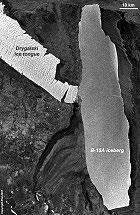


51 ENVISAT mission: Department of Geography 10 years Envisat Iceland 2010 Arctic 2007 Ozone hole 2005 L Aquila 2009 First images Japan 2011 Global air pollution Chlorophyll concentration B-15A iceberg CO2 map Prestige tanker oil slick Bam earthquake more than 4000 science projects Launch Hurricane Katrina /31/15 Envisat Symposium Envisat Symposium Living Planet Symposium Living Planet Symposium Salzburg (A) Montreux (CH) Bergen (N) Edinburgh (UK) Page 51 and many workshops dedicated to specific Envisat user communities

52 MERIS" ASAR" GOMOS" AATSR" MEdium Resolution Imaging Spectrometer" Advanced Synthetic Aperture Radar" Global Ozone Monitoring by Occultation of Stars" Advanced Along Track Scanning Radiometer" RA-2" Radar Altimeter 2" SCIAMACHY" MIPAS" MWR" LRR" DORIS" SCanning Imaging Absorption SpectroMeter for Atmospheric CartograpHY" Michelson Interferometer for Passive Atmospheric Sounding" MicroWave Radiometer" Laser RetroReflector" Doppler Orbitography and Radiopositioning Integrated by Satellite"

 MERIS measured solar radiation reflected from the earth s surface and clouds in the visible and")
53 Envisat Instruments Advanced Synthetic Aperture Radar (ASAR) As a high-resolution, wide-swath imaging radar, this is the largest Envisat instrument and produces high quality colour images of the oceans, coastal zones, polar ice and land regions irrespective of weather conditions, cloud coverage or night/daytime. Medium Resolution Imaging Spectrometer (MERIS) MERIS measured solar radiation reflected from the earth s surface and clouds in the visible and infrared parts of the spectrum. MERIS detected biophysical properties (e.g chlorophyll concentration) of the oceans and coastal water composition.
")

54 Department of Geography ASAR (Advanced Synthetic Aperture Radar) 22 June 2010 Scientific goal: continued global SAR monitoring (ERS-1/2) of land and oceans Applications: Landscape topography, snow and ice, land cover, soil moisture, ocean currents, wave heights, shipping routes,!


55 Department of Geography MERIS (MEdium Resolution Imaging Spectrometer) Scientific goal: monitoring of coastal and ocean waters, atmospheric properties and terrestrial environments Applications: concentration of suspended chlorophyll and sediments, aerosols, vegetation characteristics


56 Data from space pose an essential basis for applying international environment-treaties 3/31/15 Page 56

57 ESA s Earth Explorers Objective: Better understanding of Earth Science in various fields of interest based on innovative satellite technology Satellit GOCE SMOS Ziel der globalen Forschungen Bestimmung des Erdschwerefeldes Bodenfeuchte, Salzgehalt der Meere Start CryoSat Erfassung der planetaren Eismassen SWARM Erdmagnetfeld und Klima ADM-Aeolus Dynamik der Erdatmosphäre 2015 (geplant) EarthCARE Wolken und Aerosole 2016 (geplant) Biomass Biomasse der Wälder 2020 (geplant)

58 GOCE (Gravity Field and Steady-State Ocean Circulation Explorer) GOCE is a technology marvel: the first gradiometer in space at one of the lowest satellite orbits ever (260 km) Operated: March 2009 November 2013 Scientific goal: measure the global earth gravity field with an accuracy of 1-2 cm Spatial resolution: better than 100 km Applications: mean reference sea level, ocean circulation models, planetary interior Sensor: gradiometer, 3 pairs of 3-axis Data: for the general public (no costs)


59 GOCE (terms and definitions) Geoid: The equipotential surface of the Earth's gravity field which best fits, in a least squares sense, global mean sea level Mohorovi!i" discontinuity (aka Moho): is the boundary between the Earth's crust and the mantle. Presumably a marked change of composition (Basalt vs. Peridotit) discovered by the velocities of primary seismic waves.

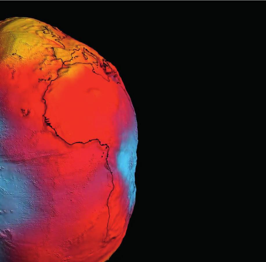
60 GOCE Geoid


61 GOCE Applications: Moho

62 Cryosat (Cryosphere Satellite) Cryosat is the second of its kind: the first Cryosat failed during launch in 2005 Launched: April 8 th, 2010 Scientific goal: determine variations in the thickness of the Earth's marine ice cover Applications: melt contributions to global sea level rise, sea-ice thickness and mass Sensor: radar altimeter Data: for the general public (no costs)

63 Cryosat: Ice stripping

64 Satellite data: global sea-level rise


65 Sea level change


66 SMOS (Soil Moisture and Ocean Salinity) Launched: November 2 nd, 2009 Scientific goal: monitor soil moisture and ocean salinity, characterization of ice & snow Applications: climatological, oceanographic, meteorological, hydrological, agronomical, and glaciological science Sensor: 2-D interferometric radiometer Data: for the general public (no costs)


67 SMOS Application: Soil Moisture


68 Department of Geography SMOS: Drought in Europe 2012 Inter-annual variation of water available in soils across Europe (images CESBIO):! Western Europe: severe lack of water due to less than average rainfall! Absence of sufficient water resources: diminishing food supply, shortage of water for households and industry, shipping routes can fall dry SMOS February 2011 SMOS February 2012


69 SWARM (Earth's magnetic field) Launched: November 22 nd, 2013 Scientific goal: measure the Earth s magnetic field and signals Applications: insight into inside processes that drive Earth s dynamo, Core dynamics, and core mantle interaction Configuration: Three identical satellites with Vector Field Magnetometer


70 SWARM constellation

71 ADM Aeolus (Atmospheric Dynamics Mission) Launch: scheduled for 2015 Scientific goal: acquire global wind profiles Applications: numerical weather predictions, climate studies, global warming to the effects of pollution Sensor: ALADIN - Atmospheric LAser Doppler INstrument Earth s wind patterns
 Launch: scheduled for 2016 Scientific goal:")


72 Earth Care (Earth Clouds, Aerosols and Radiation Explorer) Launch: scheduled for 2016 Scientific goal: observe natural and anthropogenic aerosols, atmospheric liquid water and ice, and cloud-precipitation interactions Applications: numerical weather predictions, climate studies, global warming to the effects of pollution Sensor: high-resolution atmospheric lidar and a radar, a multispectral imager and a broadband radiometer

73 Biomass Launch: scheduled for 2020 Scientific goal: measurements of forest biomass Applications: assess terrestrial carbon stocks and fluxes, ice-sheet thickness, subsurface geology in arid regions, soil moisture, permafrost and sea-surface salinity Sensor: novel P-band synthetic aperture polarimetric radar
74 Questions and Answers Any questions so far? 3/31/15 Page 74


75 Summary slides


76 Department of Geography Summary slides

77 Thank you for your attention & have a nice day!
Copernicus Introduction Lisbon, Portugal 13 th & 14 th February 2014
 Copernicus Introduction Lisbon, Portugal 13 th & 14 th February 2014 Contents Introduction GMES Copernicus Six thematic areas Infrastructure Space data An introduction to Remote Sensing In-situ data Applications
Lecture 6: Multispectral Earth Resource Satellites. The University at Albany Fall 2018 Geography and Planning
 Lecture 6: Multispectral Earth Resource Satellites The University at Albany Fall 2018 Geography and Planning Outline SPOT program and other moderate resolution systems High resolution satellite systems
How to access EO data
 How to access EO data PAC USF USF PDHS LRAC USCF PDCC Europe s expanding EO Capability Continuity & Evolution Wind Scatterometer (Low rate) all weather; day and night SAR Antenna (C-Band, 5.3 GHz) image
The studies began when the Tiros satellites (1960) provided man s first synoptic view of the Earth s weather systems.
 provided man s first synoptic view of the Earth s weather systems.") Remote sensing of the Earth from orbital altitudes was recognized in the mid-1960 s as a potential technique for obtaining information important for the effective use and conservation of natural resources.
Remote sensing of the Earth from orbital altitudes was recognized in the mid-1960 s as a potential technique for obtaining information important for the effective use and conservation of natural resources.
3/31/03. ESM 266: Introduction 1. Observations from space. Remote Sensing: The Major Source for Large-Scale Environmental Information
 Remote Sensing: The Major Source for Large-Scale Environmental Information Jeff Dozier Observations from space Sun-synchronous polar orbits Global coverage, fixed crossing, repeat sampling Typical altitude
Remote sensing radio applications/ systems for environmental monitoring
 Remote sensing radio applications/ systems for environmental monitoring Alexandre VASSILIEV ITU Radiocommunication Bureau phone: +41 22 7305924 e-mail: alexandre.vassiliev@itu.int 1 Source: European Space
NON-PHOTOGRAPHIC SYSTEMS: Multispectral Scanners Medium and coarse resolution sensor comparisons: Landsat, SPOT, AVHRR and MODIS
 NON-PHOTOGRAPHIC SYSTEMS: Multispectral Scanners Medium and coarse resolution sensor comparisons: Landsat, SPOT, AVHRR and MODIS CLASSIFICATION OF NONPHOTOGRAPHIC REMOTE SENSORS PASSIVE ACTIVE DIGITAL
remote sensing? What are the remote sensing principles behind these Definition
 Introduction to remote sensing: Content (1/2) Definition: photogrammetry and remote sensing (PRS) Radiation sources: solar radiation (passive optical RS) earth emission (passive microwave or thermal infrared
9/12/2011. Training Course Remote Sensing Basic Theory & Image Processing Methods September 2011
 Training Course Remote Sensing Basic Theory & Image Processing Methods 19 23 September 2011 Popular Remote Sensing Sensors & their Selection Michiel Damen (September 2011) damen@itc.nl 1 Overview Low resolution
Introduction of Satellite Remote Sensing
 Introduction of Satellite Remote Sensing Spatial Resolution (Pixel size) Spectral Resolution (Bands) Resolutions of Remote Sensing 1. Spatial (what area and how detailed) 2. Spectral (what colors bands)
SATELLITE OCEANOGRAPHY
 SATELLITE OCEANOGRAPHY An Introduction for Oceanographers and Remote-sensing Scientists I. S. Robinson Lecturer in Physical Oceanography Department of Oceanography University of Southampton JOHN WILEY
ESA Agency Report. Bojan R. Bojkov
 Sentinel-3 ESA Agency Report Bojan R. Bojkov Head, Sensor Performance, Products and Algorithms Directorate of Earth Observation Programmes European Space Agency (ESA/ESRIN) ESA Earth Observation missions
An Introduction to Remote Sensing & GIS. Introduction
 An Introduction to Remote Sensing & GIS Introduction Remote sensing is the measurement of object properties on Earth s surface using data acquired from aircraft and satellites. It attempts to measure something
ESA Sensor Performance, Products and Algorithms
 ESA Sensor Performance, Products and Algorithms Bojan R. Bojkov Head, Sensor Performance, Products and Algorithms Ground Segment and Mission Operations Department ESRIN, Frascati, Italy ESA EO missions
Introduction to Remote Sensing Fundamentals of Satellite Remote Sensing. Mads Olander Rasmussen
 Introduction to Remote Sensing Fundamentals of Satellite Remote Sensing Mads Olander Rasmussen (mora@dhi-gras.com) 01. Introduction to Remote Sensing DHI What is remote sensing? the art, science, and technology
The studies began when the Tiros satellites (1960) provided man s first synoptic view of the Earth s weather systems.
 provided man s first synoptic view of the Earth s weather systems.") Remote sensing of the Earth from orbital altitudes was recognized in the mid-1960 s as a potential technique for obtaining information important for the effective use and conservation of natural resources.
Remote sensing of the Earth from orbital altitudes was recognized in the mid-1960 s as a potential technique for obtaining information important for the effective use and conservation of natural resources.
The ESA Earth Observation Programmes Status and Perspectives
 The ESA Earth Observation Programmes Status and Perspectives Meeting of the Space Studies Board s Committee on Earth Science and Applications from Space (CESAS) Washington DC 4 March 2014 Dr. Maurice Borgeaud
IKONOS High Resolution Multispectral Scanner Sensor Characteristics
 High Spatial Resolution and Hyperspectral Scanners IKONOS High Resolution Multispectral Scanner Sensor Characteristics Launch Date View Angle Orbit 24 September 1999 Vandenberg Air Force Base, California,
Lecture Notes Prepared by Prof. J. Francis Spring Remote Sensing Instruments
 Lecture Notes Prepared by Prof. J. Francis Spring 2005 Remote Sensing Instruments Material from Remote Sensing Instrumentation in Weather Satellites: Systems, Data, and Environmental Applications by Rao,
Passive Microwave Sensors LIDAR Remote Sensing Laser Altimetry. 28 April 2003
 Passive Microwave Sensors LIDAR Remote Sensing Laser Altimetry 28 April 2003 Outline Passive Microwave Radiometry Rayleigh-Jeans approximation Brightness temperature Emissivity and dielectric constant
Remote Sensing 1 Principles of visible and radar remote sensing & sensors
 Remote Sensing 1 Principles of visible and radar remote sensing & sensors Nick Barrand School of Geography, Earth & Environmental Sciences University of Birmingham, UK Field glaciologist collecting data
Int n r t o r d o u d c u ti t on o n to t o Remote Sensing
 Introduction to Remote Sensing Definition of Remote Sensing Remote sensing refers to the activities of recording/observing/perceiving(sensing)objects or events at far away (remote) places. In remote sensing,
Microwave Remote Sensing
 Provide copy on a CD of the UCAR multi-media tutorial to all in class. Assign Ch-7 and Ch-9 (for two weeks) as reading material for this class. HW#4 (Due in two weeks) Problems 1,2,3 and 4 (Chapter 7)
John P. Stevens HS: Remote Sensing Test
 Name(s): Date: Team name: John P. Stevens HS: Remote Sensing Test 1 Scoring: Part I - /18 Part II - /40 Part III - /16 Part IV - /14 Part V - /93 Total: /181 2 I. History (3 pts. each) 1. What is the name
Remote Sensing Platforms
 Types of Platforms Lighter-than-air Remote Sensing Platforms Free floating balloons Restricted by atmospheric conditions Used to acquire meteorological/atmospheric data Blimps/dirigibles Major role - news
Satellite Remote Sensing: Earth System Observations
 Satellite Remote Sensing: Earth System Observations Land surface Water Atmosphere Climate Ecosystems 1 EOS (Earth Observing System) Develop an understanding of the total Earth system, and the effects of
Microwave Remote Sensing (1)
") Microwave Remote Sensing (1) Microwave sensing encompasses both active and passive forms of remote sensing. The microwave portion of the spectrum covers the range from approximately 1cm to 1m in wavelength.
Microwave Remote Sensing (1) Microwave sensing encompasses both active and passive forms of remote sensing. The microwave portion of the spectrum covers the range from approximately 1cm to 1m in wavelength.
On the use of water color missions for lakes in 2021
 Lakes and Climate: The Role of Remote Sensing June 01-02, 2017 On the use of water color missions for lakes in 2021 Cédric G. Fichot Department of Earth and Environment 1 Overview 1. Past and still-ongoing
Fundamentals of Remote Sensing
 Climate Variability, Hydrology, and Flooding Fundamentals of Remote Sensing May 19-22, 2015 GEO-Latin American & Caribbean Water Cycle Capacity Building Workshop Cartagena, Colombia 1 Objective To provide
Chapter 8. Remote sensing
 1. Remote sensing 8.1 Introduction 8.2 Remote sensing 8.3 Resolution 8.4 Landsat 8.5 Geostationary satellites GOES 8.1 Introduction What is remote sensing? One can describe remote sensing in different
Remote Sensing. Division C. Written Exam
 Remote Sensing Division C Written Exam Team Name: Team #: Team Members: _ Score: /132 A. Matching (10 points) 1. Nadir 2. Albedo 3. Diffraction 4. Refraction 5. Spatial Resolution 6. Temporal Resolution
746A27 Remote Sensing and GIS. Multi spectral, thermal and hyper spectral sensing and usage
 746A27 Remote Sensing and GIS Lecture 3 Multi spectral, thermal and hyper spectral sensing and usage Chandan Roy Guest Lecturer Department of Computer and Information Science Linköping University Multi
Solid Earth Timeline with a smattering of cryosphere technology
 Solid Earth Timeline with a smattering of cryosphere technology Muhammed Kabiru Hassan * Rebecca Boon Image from http://www.clipartheaven.com/show/clipart/technology_&_communication/satellites/satellite_23-gif.html
Introduction to Satellite Remote Sensing
 Introduction to Satellite Remote Sensing Remote sensing of the Earth from orbital altitudes was recognized in the mid-1960 s as a potential technique for obtaining information important for the effective
Remote Sensing Exam 2 Study Guide
 Remote Sensing Exam 2 Study Guide Resolution Analog to digital Instantaneous field of view (IFOV) f ( cone angle of optical system ) Everything in that area contributes to spectral response mixels Sampling
UNERSITY OF NAIROBI UNIT: PRICIPLES AND APPLICATIONS OF REMOTE SENSING AND APLLIED CLIMATOLOGY
 UNERSITY OF NAIROBI DEPARTMENT OF METEOROLOGY UNIT: PRICIPLES AND APPLICATIONS OF REMOTE SENSING AND APLLIED CLIMATOLOGY COURSE CODE: SMR 308 GROUP TWO: SENSORS MEMBERS OF GROUP TWO 1. MUTISYA J.M I10/2784/2006
ADDITIONAL SATELLITE AND SENSORS
 ADDITIONAL SATELLITE AND SENSORS A list of additional satellites and sensors, along with links to appropriate websites, is presented below. ACRIMSAT (Active Cavity Radiometer Irradiance Monitor Satellite)
Remote Sensing Platforms
 Remote Sensing Platforms Remote Sensing Platforms - Introduction Allow observer and/or sensor to be above the target/phenomena of interest Two primary categories Aircraft Spacecraft Each type offers different
The use of satellite images to forecast agricultural
 The use of satellite images to forecast agricultural Luxembourg, 12.03.2014 r. Tomasz Milewski NUTS for Poland: NUTS 1 macro-regions (grup of province, voivodships) (6), NUTS 2 - regions (province,
REMOTE SENSING INTERPRETATION
 REMOTE SENSING INTERPRETATION Jan Clevers Centre for Geo-Information - WU Remote Sensing --> RS Sensor at a distance EARTH OBSERVATION EM energy Earth RS is a tool; one of the sources of information! 1
EE 529 Remote Sensing Techniques. Introduction
 EE 529 Remote Sensing Techniques Introduction Course Contents Radar Imaging Sensors Imaging Sensors Imaging Algorithms Imaging Algorithms Course Contents (Cont( Cont d) Simulated Raw Data y r Processing
QuikScat 6/19/ km AM, 6PM. 705 km :00 PM SeaWiFS. 705 km :01 AM. SeaWinds. Aqua (PM) 5/4/02
 5/4/02") 1997-2004 Revised: 7 January 2009 1997 1998 1999 2000 OrbView-2 1 8/1/97 12:00 PM SeaWiFS TRMM 11/27/97 402 km 35 CERES LIS VIRS TMI PR Landsat 7 4/15/99 10:05 AM ETM+ QuikScat 6/19/99 803 km 98.6 6 AM,
1997-2004 Revised: 7 January 2009 1997 1998 1999 2000 OrbView-2 1 8/1/97 12:00 PM SeaWiFS TRMM 11/27/97 402 km 35 CERES LIS VIRS TMI PR Landsat 7 4/15/99 10:05 AM ETM+ QuikScat 6/19/99 803 km 98.6 6 AM,
Satellite Imagery and Remote Sensing. DeeDee Whitaker SW Guilford High EES & Chemistry
 Satellite Imagery and Remote Sensing DeeDee Whitaker SW Guilford High EES & Chemistry whitakd@gcsnc.com Outline What is remote sensing? How does remote sensing work? What role does the electromagnetic
The Global Imager (GLI)
") The Global Imager (GLI) Launch : Dec.14, 2002 Initial check out : to Apr.14, 2003 (~L+4) First image: Jan.25, 2003 Second image: Feb.6 and 7, 2003 Calibration and validation : to Dec.14, 2003(~L+4) for
The Global Imager (GLI) Launch : Dec.14, 2002 Initial check out : to Apr.14, 2003 (~L+4) First image: Jan.25, 2003 Second image: Feb.6 and 7, 2003 Calibration and validation : to Dec.14, 2003(~L+4) for
Some Basic Concepts of Remote Sensing. Lecture 2 August 31, 2005
 Some Basic Concepts of Remote Sensing Lecture 2 August 31, 2005 What is remote sensing Remote Sensing: remote sensing is science of acquiring, processing, and interpreting images and related data that
An Introduction to Geomatics. Prepared by: Dr. Maher A. El-Hallaq خاص بطلبة مساق مقدمة في علم. Associate Professor of Surveying IUG
 An Introduction to Geomatics خاص بطلبة مساق مقدمة في علم الجيوماتكس Prepared by: Dr. Maher A. El-Hallaq Associate Professor of Surveying IUG 1 Airborne Imagery Dr. Maher A. El-Hallaq Associate Professor
New capabilities in Earth Observation for agriculture
 New capabilities in Earth Observation for agriculture Prof. Katarzyna Dabrowska-Zielinska Head of Remote Sensing Department Institute of Geodesy and Cartography Modzelewskiego 27 Street 02-679 Warsaw Poland
Remote Sensing and GIS
 Remote Sensing and GIS Atmosphere Reflected radiation, e.g. Visible Emitted radiation, e.g. Infrared Backscattered radiation, e.g. Radar (λ) Visible TIR Radar & Microwave 11/9/2017 Geo327G/386G, U Texas,
Remote Sensing for Resource Management
 Remote Sensing for Resource Management Ebenezer Nyadjro US Naval Research Lab/UNO RMU Summer Program (July 31-AUG 4, 2017) Motivation Polluted Pra River Motivation. 3 Motivation Polluted Pra River Motivation.
Outline. Introduction. Introduction: Film Emulsions. Sensor Systems. Types of Remote Sensing. A/Prof Linlin Ge. Photographic systems (cf(
 GMAT x600 Remote Sensing / Earth Observation Types of Sensor Systems (1) Outline Image Sensor Systems (i) Line Scanning Sensor Systems (passive) (ii) Array Sensor Systems (passive) (iii) Antenna Radar
Futrajaya, Malaysia JULY 12, Jeong Heon SONG. Korea Aerospace Research Institution
 J P T M 2 0 1 1 Futrajaya, Malaysia JULY 12, 2011 Jeong Heon SONG Korea Aerospace Research Institution Outline Contribution of KARI Sentinel Asia / Data Provider Node International Charter KARI Space Activities
Remote Sensing. Ch. 3 Microwaves (Part 1 of 2)
") Remote Sensing Ch. 3 Microwaves (Part 1 of 2) 3.1 Introduction 3.2 Radar Basics 3.3 Viewing Geometry and Spatial Resolution 3.4 Radar Image Distortions 3.1 Introduction Microwave (1cm to 1m in wavelength)
Remote Sensing Ch. 3 Microwaves (Part 1 of 2) 3.1 Introduction 3.2 Radar Basics 3.3 Viewing Geometry and Spatial Resolution 3.4 Radar Image Distortions 3.1 Introduction Microwave (1cm to 1m in wavelength)
The Sentinel-1 Constellation
 The Sentinel-1 Constellation Evert Attema, Sentinel-1 Mission & System Manager AGRISAR and EAGLE Campaigns Final Workshop 15-16 October 2007 ESA/ESTECNoordwijk, The Netherlands Sentinel-1 Programme Sentinel-1
QUANTITATIVE GLOBAL MAPPING OF TERRESTRIAL VEGETATION PHOTOSYNTHESIS: THE FLUORESCENCE EXPLORER (FLEX) MISSION
 MISSION") 2017 IEEE International Geoscience and Remote Sensing Symposium July 23 28, 2017 Fort Worth, Texas, USA Session MO3.L12 - International Spaceborne Imaging Spectroscopy Missions: Updates and News I QUANTITATIVE
2017 IEEE International Geoscience and Remote Sensing Symposium July 23 28, 2017 Fort Worth, Texas, USA Session MO3.L12 - International Spaceborne Imaging Spectroscopy Missions: Updates and News I QUANTITATIVE
JP Stevens High School: Remote Sensing
 1 Name(s): ANSWER KEY Date: Team name: JP Stevens High School: Remote Sensing Scoring: Part I - /18 Part II - /40 Part III - /16 Part IV - /14 Part V - /93 Total: /181 2 I. History (3 pts each) 1. What
Radio Frequency Sensing from Space
 Radio Frequency Sensing from Space Edoardo Marelli ITU-R WP 7C Chairman ITU-R Seminar Manta (Ecuador) 20 September 2012 Why observing the Earth from space? Satellites orbiting around the Earth offer an
MERIS US Workshop. 14 July 2008
 MERIS US Workshop 14 July 2008 MERIS US Workshop 08:10-08:55 08:55-09:10 H. Laur (ESA) Agenda a.m. ENVISAT/MERIS mission status, access to MERIS data and distribution policy Discussion 09:10-09:40 09:40-10:00
Introduction to Remote Sensing
 Introduction to Remote Sensing Spatial, spectral, temporal resolutions Image display alternatives Vegetation Indices Image classifications Image change detections Accuracy assessment Satellites & Air-Photos
Ghazanfar A. Khattak National Centre of Excellence in Geology University of Peshawar
 INTRODUCTION TO REMOTE SENSING Ghazanfar A. Khattak National Centre of Excellence in Geology University of Peshawar WHAT IS REMOTE SENSING? Remote sensing is the science of acquiring information about
ACTIVE SENSORS RADAR
 ACTIVE SENSORS RADAR RADAR LiDAR: Light Detection And Ranging RADAR: RAdio Detection And Ranging SONAR: SOund Navigation And Ranging Used to image the ocean floor (produce bathymetic maps) and detect objects
Remote Sensing: John Wilkin IMCS Building Room 211C ext 251. Active microwave systems (1) Satellite Altimetry
 Satellite Altimetry") Remote Sensing: John Wilkin wilkin@marine.rutgers.edu IMCS Building Room 211C 732-932-6555 ext 251 Active microwave systems (1) Satellite Altimetry Active microwave instruments Scatterometer (scattering
Remote Sensing: John Wilkin wilkin@marine.rutgers.edu IMCS Building Room 211C 732-932-6555 ext 251 Active microwave systems (1) Satellite Altimetry Active microwave instruments Scatterometer (scattering
Active and Passive Microwave Remote Sensing
 Active and Passive Microwave Remote Sensing Passive remote sensing system record EMR that was reflected (e.g., blue, green, red, and near IR) or emitted (e.g., thermal IR) from the surface of the Earth.
Remote Sensing: John Wilkin IMCS Building Room 211C ext 251. Active microwave systems (1) Satellite Altimetry
 Satellite Altimetry") Remote Sensing: John Wilkin wilkin@marine.rutgers.edu IMCS Building Room 211C 732-932-6555 ext 251 Active microwave systems (1) Satellite Altimetry Active microwave instruments Scatterometer (scattering
Remote Sensing: John Wilkin wilkin@marine.rutgers.edu IMCS Building Room 211C 732-932-6555 ext 251 Active microwave systems (1) Satellite Altimetry Active microwave instruments Scatterometer (scattering
MERIS instrument. Muriel Simon, Serco c/o ESA
 MERIS instrument Muriel Simon, Serco c/o ESA Workshop on Sustainable Development in Mountain Areas of Andean Countries Mendoza, Argentina, 26-30 November 2007 ENVISAT MISSION 2 Mission Chlorophyll case
Lecture 13: Remotely Sensed Geospatial Data
 Lecture 13: Remotely Sensed Geospatial Data A. The Electromagnetic Spectrum: The electromagnetic spectrum (Figure 1) indicates the different forms of radiation (or simply stated light) emitted by nature.
GEOS 107: The Planet Earth Session 7. Geographic Information Science: Remote Sensing, GIS and GPS/1. Dr. Mark J Chopping
 GEOS 107: The Planet Earth Session 7 Geographic Information Science: Remote Sensing, GIS and GPS/1 Dr. Mark J Chopping Geographic Information Science We have 3 sessions on Geographic Information Science:
Multispectral Scanners for Wildland Fire Assessment NASA Ames Research Center Earth Science Division. Bruce Coffland U.C.
 Multispectral Scanners for Wildland Fire Assessment NASA Earth Science Division Bruce Coffland U.C. Santa Cruz Slide Fire Burn Area (MASTER/B200) R 2.2um G 0.87um B 0.65um Airborne Science & Technology
Final Examination Introduction to Remote Sensing. Time: 1.5 hrs Max. Marks: 50. Section-I (50 x 1 = 50 Marks)
") Final Examination Introduction to Remote Sensing Time: 1.5 hrs Max. Marks: 50 Note: Attempt all questions. Section-I (50 x 1 = 50 Marks) 1... is the technology of acquiring information about the Earth's
Final Examination Introduction to Remote Sensing Time: 1.5 hrs Max. Marks: 50 Note: Attempt all questions. Section-I (50 x 1 = 50 Marks) 1... is the technology of acquiring information about the Earth's
Sommersemester Prof. Dr. Christoph Kleinn Institut für Waldinventur und Waldwachstum Arbeitsbereich Fernerkundung und Waldinventur.
 Basics of Remote Sensing Some literature references Franklin, SE 2001 Remote Sensing for Sustainable Forest Management Lewis Publishers 407p Lillesand, Kiefer 2000 Remote Sensing and Image Interpretation
RADAR (RAdio Detection And Ranging)
") RADAR (RAdio Detection And Ranging) CLASSIFICATION OF NONPHOTOGRAPHIC REMOTE SENSORS PASSIVE ACTIVE DIGITAL CAMERA THERMAL (e.g. TIMS) VIDEO CAMERA MULTI- SPECTRAL SCANNERS VISIBLE & NIR MICROWAVE Real
RADAR (RAdio Detection And Ranging) CLASSIFICATION OF NONPHOTOGRAPHIC REMOTE SENSORS PASSIVE ACTIVE DIGITAL CAMERA THERMAL (e.g. TIMS) VIDEO CAMERA MULTI- SPECTRAL SCANNERS VISIBLE & NIR MICROWAVE Real
Part I. The Importance of Image Registration for Remote Sensing
 Part I The Importance of Image Registration for Remote Sensing 1 Introduction jacqueline le moigne, nathan s. netanyahu, and roger d. eastman Despite the importance of image registration to data integration
746A27 Remote Sensing and GIS
 746A27 Remote Sensing and GIS Lecture 1 Concepts of remote sensing and Basic principle of Photogrammetry Chandan Roy Guest Lecturer Department of Computer and Information Science Linköping University What
Sensor resolutions from space: the tension between temporal, spectral, spatial and swath. David Bruce UniSA and ISU
 Sensor resolutions from space: the tension between temporal, spectral, spatial and swath David Bruce UniSA and ISU 1 Presentation aims 1. Briefly summarize the different types of satellite image resolutions
Geo/SAT 2 INTRODUCTION TO REMOTE SENSING
 Geo/SAT 2 INTRODUCTION TO REMOTE SENSING Paul R. Baumann, Professor Emeritus State University of New York College at Oneonta Oneonta, New York 13820 USA COPYRIGHT 2008 Paul R. Baumann Introduction Remote
Using Freely Available. Remote Sensing to Create a More Powerful GIS
 Using Freely Available Government Data and Remote Sensing to Create a More Powerful GIS All rights reserved. ENVI, E3De, IAS, and IDL are trademarks of Exelis, Inc. All other marks are the property of
REMOTE SENSING. Topic 10 Fundamentals of Digital Multispectral Remote Sensing MULTISPECTRAL SCANNERS MULTISPECTRAL SCANNERS
 REMOTE SENSING Topic 10 Fundamentals of Digital Multispectral Remote Sensing Chapter 5: Lillesand and Keifer Chapter 6: Avery and Berlin MULTISPECTRAL SCANNERS Record EMR in a number of discrete portions
Active microwave systems (1) Satellite Altimetry
 Satellite Altimetry") Remote Sensing: John Wilkin Active microwave systems (1) Satellite Altimetry jwilkin@rutgers.edu IMCS Building Room 214C 732-932-6555 ext 251 Active microwave instruments Scatterometer (scattering from
Remote Sensing: John Wilkin Active microwave systems (1) Satellite Altimetry jwilkin@rutgers.edu IMCS Building Room 214C 732-932-6555 ext 251 Active microwave instruments Scatterometer (scattering from
Aral Sea profile Selection of area 24 February April May 1998
 250 km Aral Sea profile 1960 1960 1985 1986 1987 1988 1989 1990 1991 1992 1993 1994 1995 1996 1997 1998 2010? Selection of area Area of interest Kzyl-Orda Dried seabed 185 km Syrdarya river Aral Sea Salt
Govt. Engineering College Jhalawar Model Question Paper Subject- Remote Sensing & GIS
 Govt. Engineering College Jhalawar Model Question Paper Subject- Remote Sensing & GIS Time: Max. Marks: Q1. What is remote Sensing? Explain the basic components of a Remote Sensing system. Q2. What is
Active and Passive Microwave Remote Sensing
 Active and Passive Microwave Remote Sensing Passive remote sensing system record EMR that was reflected (e.g., blue, green, red, and near IR) or emitted (e.g., thermal IR) from the surface of the Earth.
Introduction to Remote Sensing
 Introduction to Remote Sensing Dr. Mathias (Mat) Disney UCL Geography Office: 301, 3rd Floor, Chandler House Tel: 7670 4290 Email: mdisney@ucl.geog.ac.uk www.geog.ucl.ac.uk/~mdisney 1 Course outline Format
Workshop on Practical Applications of MODIS Data in Australia
 Workshop on Practical Applications of MODIS Data in Australia Leeuwin Centre, Floreat WA November 26-29, 2002 Liam Gumley Space Science and Engineering Center University of Wisconsin-Madison Introduction
Remote Sensing : An overview
 Remote Sensing : An overview Contents Introduction Historical review Applications Electromagnetic spectrum Interaction with atmosphere- Atmospheric windows Spectral signature Multispectral Space Multispectral
2017 REMOTE SENSING EVENT TRAINING STRATEGIES 2016 SCIENCE OLYMPIAD COACHING ACADEMY CENTERVILLE, OH
 2017 REMOTE SENSING EVENT TRAINING STRATEGIES 2016 SCIENCE OLYMPIAD COACHING ACADEMY CENTERVILLE, OH This presentation was prepared using draft rules. There may be some changes in the final copy of the
Radiometric performance of Second Generation Global Imager (SGLI) using integrating sphere
 using integrating sphere") Radiometric performance of Second Generation Global Imager (SGLI) using integrating sphere Taichiro Hashiguchi, Yoshihiko Okamura, Kazuhiro Tanaka, Yukinori Nakajima Japan Aerospace Exploration Agency
Radiometric performance of Second Generation Global Imager (SGLI) using integrating sphere Taichiro Hashiguchi, Yoshihiko Okamura, Kazuhiro Tanaka, Yukinori Nakajima Japan Aerospace Exploration Agency
AGRON / E E / MTEOR 518: Microwave Remote Sensing
 AGRON / E E / MTEOR 518: Microwave Remote Sensing Dr. Brian K. Hornbuckle, Associate Professor Departments of Agronomy, ECpE, and GeAT bkh@iastate.edu What is remote sensing? Remote sensing: the acquisition
Roland Meynart. Earth Oservation Programmes Directorate ESA
 Technologies for post-eps and possibly needed developments Roland Meynart Earth Oservation Programmes Directorate ESA With the contributions of my AEG colleagues M.Betto, U.Del Bello, C.C.Lin, Y. Durand,
From Proba-V to Proba-MVA
 From Proba-V to Proba-MVA Fabrizio Niro ESA Sensor Performances Products and Algorithm (SPPA) ESA UNCLASSIFIED - For Official Use Proba-V extension in the Copernicus era Proba-V was designed with the main
Light penetration within a clear water body. E z = E 0 e -kz
 THE BLUE PLANET 1 2 Light penetration within a clear water body E z = E 0 e -kz 3 4 5 Pure Seawater Phytoplankton b w 10-2 m -1 b w 10-2 m -1 b w, Morel (1974) a w, Pope and Fry (1997) b chl,loisel and
A map says to you, 'Read me carefully, follow me closely, doubt me not.' It says, 'I am the Earth in the palm of your hand. Without me, you are alone
 A map says to you, 'Read me carefully, follow me closely, doubt me not.' It says, 'I am the Earth in the palm of your hand. Without me, you are alone and lost. Beryl Markham (West With the Night, 1946
Canadian Space Agency program update
 Canadian Space Agency program update Briefing to the meeting of the Expert Team on Satellite Systems (ET-SAT-11) Geneva, 4 April 2017 Guennadi Kroupnik Canadian Space Agency RADARSAT-2: CURRENT OPERATIONAL
Typical technical and operational characteristics of Earth exploration-satellite service (passive) systems using allocations between 1.
 systems using allocations between 1.") Recommendation ITU-R RS.1861 (01/2010) Typical technical and operational characteristics of Earth exploration-satellite service (passive) systems using allocations between 1.4 and 275 GHz RS Series Remote
Recommendation ITU-R RS.1861 (01/2010) Typical technical and operational characteristics of Earth exploration-satellite service (passive) systems using allocations between 1.4 and 275 GHz RS Series Remote
9/12/2011. Training Course Remote Sensing Basic Theory & Image Processing Methods September 2011
 Training Course Remote Sensing Basic Theory & Image Processing Methods 19 23 September 2011 Remote Sensing Platforms Michiel Damen (September 2011) damen@itc.nl 1 Overview Platforms & missions aerial surveys
ESA's activities in space-borne Imaging Spectroscopy for Earth Observation CHII, June 2016, Graz, Austria
 ESA's activities in space-borne Imaging Spectroscopy for Earth Observation CHII, 15-16 June 2016, Graz, Austria Michael Rast, ESA Observation Principle of Imaging Spectrometer The telescope images the
The Earth Observation Programme at ESA
 The Earth Observation Programme at ESA 24-October-2007, International Ice Charting Working Group Meeting Simon.Jutz@esa.int Earth Observation Programmes Directorate European Space Agency EO missions handled
RADAR REMOTE SENSING
 RADAR REMOTE SENSING Jan G.P.W. Clevers & Steven M. de Jong Chapter 8 of L&K 1 Wave theory for the EMS: Section 1.2 of L&K E = electrical field M = magnetic field c = speed of light : propagation direction
Remote Sensing for Rangeland Applications
 Remote Sensing for Rangeland Applications Jay Angerer Ecological Training June 16, 2012 Remote Sensing The term "remote sensing," first used in the United States in the 1950s by Ms. Evelyn Pruitt of the
REMOTE SENSING FOR FLOOD HAZARD STUDIES.
 REMOTE SENSING FOR FLOOD HAZARD STUDIES. OPTICAL SENSORS. 1 DRS. NANETTE C. KINGMA 1 Optical Remote Sensing for flood hazard studies. 2 2 Floods & use of remote sensing. Floods often leaves its imprint
Image interpretation and analysis
 Image interpretation and analysis Grundlagen Fernerkundung, Geo 123.1, FS 2014 Lecture 7a Rogier de Jong Michael Schaepman Why are snow, foam, and clouds white? Why are snow, foam, and clouds white? Today
29 th Annual Louisiana RS/GIS Workshop April 23, 2013 Cajundome Convention Center Lafayette, Louisiana
 Landsat Data Continuity Mission 29 th Annual Louisiana RS/GIS Workshop April 23, 2013 Cajundome Convention Center Lafayette, Louisiana http://landsat.usgs.gov/index.php# Landsat 5 Sets Guinness World Record