Brazilian GBAS experience
|
|
|
- Shanon Cunningham
- 6 years ago
- Views:
Transcription
1
2 Workshop for the implementation of Navigation Infraestructure to support PBN and GNSS precision approach in NAM/CAR/SAM Region Session 3: Current GNSS Situation and Evolution Brazilian GBAS experience Alessander de Andrade Santoro - Brazil August 16 th, 2016


3 MOTIVAÇÃO Continuos increase of demand Necessity for synchronization of CNS/ATM deployment in the world Increased efficiency = increased safety and lower costs
4 Objective Present Brazilian Ground Based Augmentation System (GBAS) experience

5 Brazilian FIR

6 13 International Adjoint FIR
7 Area comparison AMAZON FIR km 2 USA: 30 States 32 European countries

8 Radar Covereage FL290

9 Air traffic operations
10 CNS Equipments Equipment Qty Primary radar 69 Secondary radar 84 Weather radar 17 Ground radar 1 PAR 6 VOR 84 DME 112 NDB 187 ILS 88 PAPI/VASIS 83 ALS 21 VHF/UHF/HF 8458 Meteorological station 196
11 Procedures Type Qty IAC NDB 157 IAC VOR 179 IAC ILS 121 IAC LOC 57 IAC RNAV 215 RNAV ROUTES 140 CONVENTIONAL ROUTES 77
12 Standards (Annex 10 ICAO) Accuracy Availability Continuity Integrity According to the phase of flight

13 VANTAGES ell known technology perational confidence arge network DISADVANTAGES Analogic modulation interference and channel management Low range Low procedure flexibility Site constraints


14 Performance Based Navigation Less distance Less fuel Less $$$ Less CO2

15 Gate to gate Surface Movement GBAS Applications SBAS GBAS SBAS SBAS GBAS GBAS GBAS GBAS Airport Movements Uplinked Data Guided Precision Missed Approach Conceito GATE TO GATE First come, first served On time, first served
 Need of augmentation Accuracy Integrity Availability")
16 Global Positioning System Enroute Non precision Approach (reduction of MDA) Need of augmentation Accuracy Integrity Availability Continuity
 São José dos Campos Flight")

17 Honeywell SLS SCAT I operations in Joinvile (Rio Sul) São José dos Campos Flight Inspection Aircraft EMB-110 Type of technology Operational in Norway till present

18 S B A S 18

19 SBAS Test Plataform TEGUCIGALPA FAA Master Station BOGOTA MANAUS LIMA BRASILIA RECIFE El Alto ANTOFAGASTA RIO DE JANEIRO CURITIBA SANTIAGO EZEIZA MASTER STATION BALMACEDA REFERENCE STATION VHF-DL
20 RLA/00/009 PROJECT GNSS AUGMENTATION TRIALS SBAS augmentation trials in the CAR/SAM Regions MOU ICAO/FAA: signed on 2 June 2001 First flight trials in Brazil It was proven that the ionosphere effect over the GPS signal did not guarantee NPA approaches with vertical precision requirements Final report RCC/5-RLA/00/009-WP/03
21 SBAS in Equatorial Regions RLA/00/009 PROJECT GNSS AUGMENTATION TRIALS NAVIGATION SYSTEMS PANEL (NSP) - Ionospheric Effects on GNSS Aviation Operations ICAO Doc GNSS Manual IATA Report on User Requirements for Air Traffic Services Do not support the continued investment, development, and implementation of SBAS.

22 GBAS Ground Based Augmentation System 22

23 Continuous Descent Benefits One GBAS multiple approaches - up to 48 approach procedures Flexible sitting requirements Improved accuracy of positioning service Reduced building restrictions - construction of new terminals and hangars Flexible use - curved approach paths, different glide path angles, off set thresholds, etc 23
24 FAA / DECEA Cooperative History MOC / NAT-I-0801 Development of Civil Aviation Jan 2000 MOA / NAT-I-0019 Technical Assistance Jun 2000 MOC NAT-I-4016 Technical Assistance Jul 2015 Annex 1 (Oct,2001) GNSS Flight Test Trials and Demonstrations Annex 1 (Nov,2000) Purchase of equipment Appendix 1 Annex 1 (In Coord) Atmospheric Ionospheric Research Annex 2 (Oct,2001) Ionosphere Research Loan of equipment Appendix 1 Annex 2 (Nov,2002) CARSAMMA Establishment Appendix 1 Annex 3 (Ago,2003) LTP Loan of equipment Appendix 1 Annex 3 (Nov,2003) GNSS Flight Trials Purchase of equipment Annex 4 ETMS

25 LAAS Test Prototype SGBL MoU DECEA/FAA


 06")
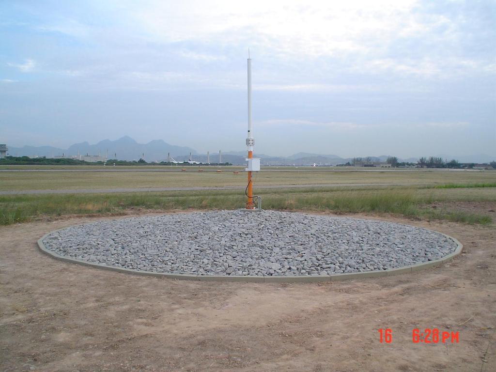
26 LAAS Test Prototype GEIV Aircrafts MMR GNU 930 (Rockwell Collins) Red label Achievements 120 approaches 03 airports (SBGL, SBRJ, SBAF) 06 runway thresholds 26

27 LAAS Test Prototype 27

28 LAAS Test Prototipe 28

29 LAAS Test Prototipe 29
30 LAAS Test Prototipe 30

31 LAAS Test Prototype 31

32 LAAS Test Prototype 32

33 LAAS Test Prototipe 33


34 LAAS Test Prototype Data collection errors Ionosphere Solar Cycle Reduce variables 34


35 SLS4000 SmartPath - SBGL June, 2011 Operation for testing purposes; Availability issues (ionosphere); Disabling monitors for data collection purposes; Approach procedures RWY 10, 15, 28 and 33.


 Omni-directional GPS Receivers 48-channel,")


36 SmartPath Components GPS Antennas Four GPS RRA/RSMU per GBAS Multipath limiting design Sharp cut-off/rejection at horizon Corrections Processor Pentium M, 1.8 GHz CPU Real time monitoring for GPS failures, local error sources Differential corrections VHF Antenna Horizontal polarized (HPOL) Omni-directional GPS Receivers 48-channel, L1 C/A GPS Signal Quality Monitoring Maintenance Data Terminal Windows OS System mode & control Component status Approach control VHF Radios Nav band, MHz D8PSK modulation, TDMA Digital data broadcast Air Traffic Status Unit Windows OS System mode Current/Predicted Availability

37 RWY 10/28 SBGL
38 GBAS AQUISITION 38
39 GBAS AQUISITION 39
40 Ionosphere 40
41 41

42 Ionosphere 42

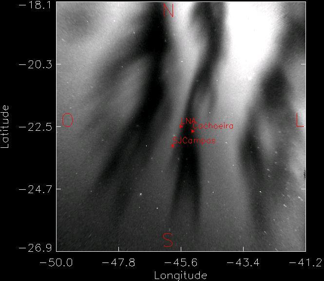
43 BRAZILIAN CONTINUOUS MONITORING NETWORK (RBMC)

44 IONO DATA COLLECTION STATIONS 44

45 CONUS THREAT MODEL 45
46 Brehmen (Germany), Newark (USA), Houston (USA), Malaga (Spain), Sydney (Australia)
47 IONO Research Network 180 receiver L1/L2 and scintilation 127 dates march 2011 / march 2014 (S4, Kp and Dst); Lowest cycle in 100 years (cycle 24); DECEA, ICEA, FAATC/NAVTAC, USTDA, Mirus Tech, SDTP, Stanford University, INPE, Boston College, UNESP, KAIST Final Report march 2015.

48 IONO RESEARCH

49 IONO RESEARCH
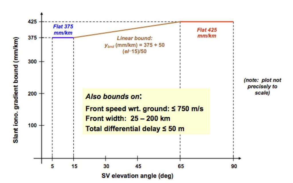
50 CONCLUSIONS of RESEARCH The highest gradient identified exceeds 850 mm/km which far exceeds the events used to define the CONUS GBAS Threat Model. Ionospheric events in the low latitudes are greater in frequency and magnitude than those in the Northern Latitudes. The current threat model implemented in SLS-4000 installation at GIG does not comply with ICAO/FAA requirements for integrity or availability.


51 Flight Inspection EMB110 / H-800XP / LEGACY 5000

52 Flight Inspection MANINV-BRASIL (2014) GNLU-930 / GLU-925 UNIFIS3000
53 Remarks about GBAS CAT I (GAST C) Only Honeywell SLS-4000 certified for CAT I (Mid Latitudes) DA within 6km (integrity) VDB coverage Block II Iono improve (only for CONUS) Expensive receiver for general aviation Cost ILS x GBAS (CBA) Concurrent technologies
54 Concurrent technologies to GAST C GAST D (CAT II/III) new receivers (SLS-5000) GBAS MF (L5) / MC (GLONASS, BEIDOU, GALILEO) SBAS LPV200 (WAAS, EGNOS) Mid latitudes SBAS MF BARO VNAV RNP-AR

55 SBRJ

56 Concurrent technologies to GAST C APP RNP AR RWY02R

57 Concurrent technologies to GAST C
58 Concurrent technologies to GAST C
; - PFF 04 Approach RNP Implementation (GBAS CAT I procedures). Information available in http://www.decea.gov.")
59 SIRIUS Program March, 2012 (PCA ); Aligned with the GANP and ASBU; Subprograms and projects CNS, ATM, MET, AIS, SAR - PFF 12 Navigation Systems Upgrade (GBAS evaluation); - PFF 04 Approach RNP Implementation (GBAS CAT I procedures). Information available in
60 CONCLUSION GBAS GAST C is operational in a few contries in mid latitudes but is still a chalenge to low latitudes Since 2003 Brazil tests GBAS stations in SBGL and technology did not meet ICAO SARPs for availabilty and integrity Brazil continues in the effort to set SLS-4000 at SBGL operational for public use New Technologies are coming to chalenge GBAS GAST C

61 Thank you Gracías Merci شكرا 谢谢 Obrigado!
RESULTS OF THE REGIONAL SBAS TEST BED TYPE WAAS PROYECT RLA/00/009. Onofrio Smarrelli ICAO SAM CNS Lima Regional Office
 WORKSHOP / SEMINAR FOR THE IMPLEMENTATION OF NAVIGATION INFRASTRUCTURE TO SUPPORT PBN AND GNSS PRECISION APPROACH OPERATIONS IN THE NAM CAR SAM REGION (Lima, Peru 15 to 17 August 2016 ) RESULTS OF THE
Excellence in Technical Solutions
 Excellence in Technical Solutions SUMARY Introduction IACIT s History Services and Products FINEP Financier of Studies and Projects GBAS IACIT Flexibility in compair with ILS Designed to Agree Perspectives
Ground Based Augmentation Systems (GBAS) Introduction
 Introduction") Ground Based Augmentation Systems (GBAS) Introduction Technical and Operational Overview Andreas Lipp GBAS Implementation Workshop, ICAO EUR/NAT Paris, 18 March 2010 The European Organisation for the Safety
Ground Based Augmentation Systems (GBAS) Introduction Technical and Operational Overview Andreas Lipp GBAS Implementation Workshop, ICAO EUR/NAT Paris, 18 March 2010 The European Organisation for the Safety
GBAS FOR ATCO. June 2017
 GBAS FOR ATCO June 2017 Disclaimer This presentation is for information purposes only. It should not be relied on as the sole source of information, and should always be used in the context of other authoritative
Aviation Benefits of GNSS Augmentation
 Aviation Benefits of GNSS Augmentation Workshop on the Applications of GNSS Chisinau, Moldova 17-21 May 2010 Jeffrey Auerbach Advisor on GNSS Affairs Office of Space and Advanced Technology U.S. Department
International Civil Aviation Organization THE SIXTH MEETING OF IONOSPHERIC STUDIES TASK FORCE (ISTF/6) OUTCOME OF THE NSP/2 MEETING
 OUTCOME OF THE NSP/2 MEETING") ISTF/6 WP/06 Agenda Item 2 15/01/16 International Civil Aviation Organization THE SIXTH MEETING OF IONOSPHERIC STUDIES TASK FORCE (ISTF/6) Bangkok, Thailand, 19 21 January 2016 Agenda Item 2: Review of
ISTF/6 WP/06 Agenda Item 2 15/01/16 International Civil Aviation Organization THE SIXTH MEETING OF IONOSPHERIC STUDIES TASK FORCE (ISTF/6) Bangkok, Thailand, 19 21 January 2016 Agenda Item 2: Review of
Performance framework for Regional Air Navigation Planning and Implementation
 GREPECAS/16 WP/21 International Civil Aviation Organization 02/03/11 CAR/SAM Regional Planning and Implementation Group (GREPECAS) Sixteenth Meeting of the CAR/SAM Regional Planning and Implementation
INTERNATIONAL CIVIL AVIATION ORGANIZATION
 INTERNATIONAL CIVIL AVIATION ORGANIZATION AFI PLANNING AND IMPLEMENTATION REGIONAL GROUP EIGHTEENTH MEETING (APIRG/18) Kampala, Uganda (27 30 March 2012) Agenda Item 3: Performance Framework for Regional
FOLLOW-UP ON ACTIVITIES OF PROJECT AIR NAVIGATION SYSTEMS IN SUPPORT OF PBN. (Presented by the Secretariat) SUMMARY
 SUMMARY") International Civil Aviation Organization SAM/IG/11-WP/17 South American Regional Office 29/4/13 Eleventh Workshop/Meeting of the SAM Implementation Group (SAM/IG/11) Regional Project RLA/06/901 (Lima,
International Civil Aviation Organization SAM/IG/11-WP/17 South American Regional Office 29/4/13 Eleventh Workshop/Meeting of the SAM Implementation Group (SAM/IG/11) Regional Project RLA/06/901 (Lima,
ICAO PBN GO TEAM PBN Implementation Workshop ENAC / ATM
 ICAO PBN GO TEAM PBN Implementation Workshop Minsk, BELARUS, 7-10 April 2015 ENAC / ATM Bertrand FOUCHER 1 PERSONAL BACKGROUND ATCO in Paris Charles de Gaulle ATC Supervisor in Paris Charles de Gaulle,
GNSS: CNS Dependencies
 GNSS: CNS Dependencies Lendina Smaja DATM/RDS/NAV 10 March 2015 Agenda The Future Technical Environment GNSS GNSS Supporting CNS Loss of Signal Impact GNSS: CNS Dependencies 2 Original FANS CNS/ATM Concept
Seminar on the Ionosphere and its Effects on GNSS Systems (Project RLA/00/009 GNSS Augmentation Trials) (Santiago, Chile, April 2008) AGENDA
 (Santiago, Chile, April 2008) AGENDA") Monday, 14 April 2008 Seminar on the Ionosphere and its Effects on GNSS Systems (Project RLA/00/009 GNSS Augmentation Trials) (Santiago, Chile, 14-16 April 2008) AGENDA REGISTRATION OF PARTICIPANTS AND
Monday, 14 April 2008 Seminar on the Ionosphere and its Effects on GNSS Systems (Project RLA/00/009 GNSS Augmentation Trials) (Santiago, Chile, 14-16 April 2008) AGENDA REGISTRATION OF PARTICIPANTS AND
IMPLEMENTATION OF GNSS BASED SERVICES
 International Civil Aviation Organization IMPLEMENTATION OF GNSS BASED SERVICES Julio Siu Communications, Navigation and Surveillance Regional Officer ICAO NACC Regional Office ICAO Workshop on PBN Airspace
Operational Benefits of Ground Based Augmentation Systems
 Operational Benefits of Ground Based Augmentation Systems Airline Perspective Ron Renk Manager, Flight Technologies/ 737 Pilot Flight Operations June 15, 2011 Today s Program What is GBAS? Why Continental
SBAS solution GCC, Yemen and Iraq System baseline and performance
 SBAS solution GCC, Yemen and Iraq System baseline and performance ACAC Workshop Rabat 7 & 8 November 2017 1 2017 Thales Alenia Space PROPRIETARY C O M MINFORMATION E R C I A L I N THALES C O ALENIA N F
Wide Area Augmentation System (WAAS)
") Wide Area Augmentation System (WAAS) Ionospheric Effects Symposium By: Jason Burns Technology Evolution Lead Date: Agenda WAAS Overview Ionospheric Effects on WAAS Future Plans User Segment Update 2 WAAS
Wide Area Augmentation System (WAAS) Ionospheric Effects Symposium By: Jason Burns Technology Evolution Lead Date: Agenda WAAS Overview Ionospheric Effects on WAAS Future Plans User Segment Update 2 WAAS
ICAO Global Provisions and Regional Developments related to GNSS
 ICAO Global Provisions and Regional Developments related to GNSS Mohamed Smaoui ICAO Deputy Regional Director, Middle East Office, Cairo, Egypt Rabat, Morocco, 7 8 November 2017 OUTLINE Introduction GNSS
Radio Navigation Aids Flight Test Seminar
 Radio Navigation Aids Flight Test Seminar FLIGHT INSPECTION IN THE NEW MILLENNIUM Curt Keedy FAA Flight Inspection Policy and Standards Change, Challenge, and Opportunity CHANGES Global Positioning system
GA and NextGen How technologies like WAAS and ADS-B will change your flying! Presented By Claire Kultgen
 GA and NextGen How technologies like WAAS and ADS-B will change your flying! Presented By Claire Kultgen Overview 1. TIS 2. ADS-B FIS-B TIS-B ADS-R 3. WAAS 4. T-Routes and GPS MEAs Questions Chat Pilot
Development of a GAST-D ground subsystem prototype and its performance evaluation with a long term-data set
 Development of a GAST-D ground subsystem prototype and its performance evaluation with a long term-data set T. Yoshihara, S. Saito, A. Kezuka, K. Hoshinoo, S. Fukushima, and S. Saitoh Electronic Navigation
Modern ARINC 743B DO-229D and DO-253C GLSSU Solutions For Retrofit
 Commercial Aviation Modern ARINC 743B DO-229D and DO-253C GLSSU Solutions For Retrofit Presented to AEEC March 2010 The Classic Retrofit Challenge Financial: Operating budget year financing ROI payback:
ICAO policy on GNSS, GNSS SARPs and global GNSS developments. Jim Nagle Chief, Communication, Navigation and Surveillance Section ICAO
 ICAO policy on GNSS, GNSS SARPs and global GNSS developments Jim Nagle Chief, Communication, Navigation and Surveillance Section ICAO Presentation overview Introduction GNSS developments in ICAO ICAO policy
Introduction to PBN and RNP
 Introduction to PBN and RNP Rick Farnworth ATM/RDS/NAV SDM PBN workshop 19 th October 2017 Summary What is PBN? Some History The ICAO PBN Manual The Benefits of PBN Some Examples PBN Approaches PBN and
GPS/WAAS Program Update
 GPS/WAAS Program Update UN/Argentina Workshop on the Applications of GNSS 19-23 March 2018 Cordoba, Argentina GNSS: A Global Navigation Satellite System of Systems Global Constellations GPS (24+3) GLONASS
AIR NAVIGATION PLAN/REGIONAL PERSPECTIVE IMPLEMENTATION OF CNS/ATM SYSTEMS
 SIP/2009 - WP/12 Performance Framework AIR NAVIGATION PLAN/REGIONAL PERSPECTIVE IMPLEMENTATION OF CNS/ATM SYSTEMS Carlos Stehli Deputy Regional Director ICAO SAM Office 1 CONTENTS ICAO REGIONAL OFFICES
Final Project Report. Abstract. Document information
 Final Project Report Document information Project Title GNSS Baseline Study Project Number 15.03.04 Project Manager LEONARDO Deliverable Name Final Project Report Deliverable ID D01 Edition 01.02.00 Template
International Civil Aviation Organization. CNS Planning and Implementation in the MID Region GNSS PLANNING AND IMPLEMENTATION
 CNS SG/8-WP/10 17/1/2018 International Civil Aviation Organization MIDANPIRG Communication, Navigation and Surveillance Sub-Group Eighth Meeting (CNS SG/8) (Cairo, Egypt, 26-28 February 2018) Agenda Item
[EN A 78] Development of a CAT III GBAS (GAST D) ground subsystem prototype and its performance evaluation with a long term data set
![[EN A 78] Development of a CAT III GBAS (GAST D) ground subsystem prototype and its performance evaluation with a long term data set](/thumbs/96/128212036.jpg "[EN A 78] Development of a CAT III GBAS (GAST D) ground subsystem prototype and its performance evaluation with a long term data set") [EN A 78] Development of a CAT III GBAS (GAST D) ground subsystem prototype and its performance evaluation with a long term data set (EIWAC 2017) + T. Yoshihara*, S. Saito*, A. Kezuka*, K. Hoshinoo*, S.
[EN A 78] Development of a CAT III GBAS (GAST D) ground subsystem prototype and its performance evaluation with a long term data set (EIWAC 2017) + T. Yoshihara*, S. Saito*, A. Kezuka*, K. Hoshinoo*, S.
GNSS Spectrum Issues and New GPS L5
 Federal Aviation Administration Washington, D.C. GNSS Spectrum Issues and New GPS L5 International Civil Aviation Organization Regional Coordination Meeting Lima, Peru March 27 28, 2001 Basic GPS System!Space
PBN fleet equipage according to FPL content. Michel ROELANDT
 PBN fleet equipage according to FPL content Michel ROELANDT EUROCONTROL RAiSG/PBN TF Meeting March 2014 Introduction 15 Nov 2012: standard ICAO format for airline flight plans changed. New fields have
[EN-A-008] GBAS Interoperability and Multi-Constellation / Multi-Frequency Trials
![[EN-A-008] GBAS Interoperability and Multi-Constellation / Multi-Frequency Trials](/thumbs/80/80771251.jpg "[EN-A-008] GBAS Interoperability and Multi-Constellation / Multi-Frequency Trials") ENRI Int. Workshop on ATM/CNS. Tokyo, Japan. (EIWAC 17) [EN-A-8] GBAS Interoperability and Multi-Constellation / Multi-Frequency Trials (EIWAC 17) + T. Feuerle *, M. Stanisak *, S. Saito, T. Yoshihara,
ENRI Int. Workshop on ATM/CNS. Tokyo, Japan. (EIWAC 17) [EN-A-8] GBAS Interoperability and Multi-Constellation / Multi-Frequency Trials (EIWAC 17) + T. Feuerle *, M. Stanisak *, S. Saito, T. Yoshihara,
REPORT OF COMMITTEE B TO THE CONFERENCE ON AGENDA ITEM 6
 1/10/03 ELEVENTH AIR NAVIGATION CONFERENCE Montreal, 22 September to 3 October 2003 REPORT OF COMMITTEE B TO THE CONFERENCE ON AGENDA ITEM 6 The attached report has been approved by Committee B for submission
Special Committee SC-159 Navigation Equipment Using the Global Navigation Satellite System (GNSS) (Version 13)
 (Version 13)") RTCA Paper No. 307-18/PMC-1839 December 13, 2018 TERMS OF REFERENCE Special Committee SC-159 Navigation Equipment Using the Global Navigation Satellite System (GNSS) (Version 13) REQUESTOR: Organization
RTCA Paper No. 307-18/PMC-1839 December 13, 2018 TERMS OF REFERENCE Special Committee SC-159 Navigation Equipment Using the Global Navigation Satellite System (GNSS) (Version 13) REQUESTOR: Organization
Navigation systems developments 2.1 Review of the results of the SBAS augmentation projects carried out in the CAR/SAM Regions
 CNS/COMM/5-WP/10 International Civil Aviation Organization 31/10/06 CAR/SAM REGIONAL PLANNING IMPLEMENTATION GROUP (GREPECAS) Fifth Meeting of the CNS Committee of the GREPECAS ATM/CNS Subgroup (CNS/COMM/5)
Japan-US Aviation Environmental Workshop Fukutake Hall University of Tokyo 29 November 2017
 Japan-US Aviation Environmental Workshop Fukutake Hall University of Tokyo 29 November 2017 Keiichi Tamura All Nippon Airways B787 Technical Pilot, Dr. Eng. 2 Fundamentals of PBN (RNAV / RNP) Fundamentals
IMPLEMENTATION OF AN SBAS-SACCSA TEST BED IN THE CAR/SAM REGIONS. (Presented by the Secretariat) SUMMARY
 SUMMARY") RLA/03/902 RCC/9 - WP/10 12/06/13 International Civil Aviation Organization South American Regional Office - Project RLA/03/902 Transition to GNSS/SBAS in the CAR/SAM Regions SACCSA Phase III Ninth Meeting
RLA/03/902 RCC/9 - WP/10 12/06/13 International Civil Aviation Organization South American Regional Office - Project RLA/03/902 Transition to GNSS/SBAS in the CAR/SAM Regions SACCSA Phase III Ninth Meeting
Special Committee SC-159 Navigation Equipment Using the Global Navigation Satellite System (GNSS) (Version 11)
 (Version 11)") RTCA Paper No. 094-18/PMC-1737 March 22, 2018 TERMS OF REFERENCE Special Committee SC-159 Navigation Equipment Using the Global Navigation Satellite System (GNSS) (Version 11) REQUESTOR: Organization Person
RTCA Paper No. 094-18/PMC-1737 March 22, 2018 TERMS OF REFERENCE Special Committee SC-159 Navigation Equipment Using the Global Navigation Satellite System (GNSS) (Version 11) REQUESTOR: Organization Person
FAA GBAS System Development. Seminar on the Ionosphere and its Effect on GNSS Systems. Carlos A. Rodriguez GBAS Program Manager
 FAA GBAS System Development for Seminar on the Ionosphere and its Effect on GNSS Systems Santiago, Chile April 14-16, 2008 Carlos A. Rodriguez GBAS Program Manager Outline LAAS Program Background Integrity
GAGAN implementation and certification Programme. Presented by India
 GAGAN implementation and certification Programme Presented by India GPS Aided Geo Augmented Navigation International Civil Aviation Organization (ICAO) Member States Endorsed Global Satellite Navigation
AEEC 2013 Presentation to the Airlines and the Aviation Industry
 AEEC 2013 Presentation to the Airlines and the Aviation Industry Multi-Frequency/Multi-Constellation (MFMC) GNSS Receivers Value for Aviation and Airlines John Studenny CMC GPS Product Manager Alain Beaulieu
PBN Operational Approval Course
 PBN Operational Approval Course Introduction and Overview PBN Operations Approval Welcome Logistics Introductions PBN Overview 2 Instructor Bob Kennedy Attendees: 3 Course Objectives The objective of this
GBAS safety assessment guidance. related to anomalous ionospheric conditions
 INTERNATIONAL CIVIL AVIATION ORGANIZATION ASIA AND PACIFIC OFFICE GBAS safety assessment guidance Edition 1.0 September 2016 Adopted by APANPIRG/27 Intentionally left blank Edition 1.0 September 2016 2
Alternate Position, Navigation & Time APNT for Civil Aviation
 Alternate Position, Navigation & Time APNT for Civil Aviation For Working Group B of the International GNSS Committee Shanghai, May 2011 by Per Enge & Leo Eldredge Work supported by the Federal Aviation
Satellite-Based Augmentation System (SBAS) Integrity Services
 Integrity Services") Satellite-Based Augmentation System (SBAS) Integrity Services Presented To: Munich, Germany Date: March 8, 2010 By: Leo Eldredge, Manager GNSS Group, FAA FAA Satellite Navigation Program 2 Wide Area Augmentation
Satellite-Based Augmentation System (SBAS) Integrity Services Presented To: Munich, Germany Date: March 8, 2010 By: Leo Eldredge, Manager GNSS Group, FAA FAA Satellite Navigation Program 2 Wide Area Augmentation
SATELLITE BASED AUGMENTATION SYSTEM (SBAS) FOR AUSTRALIA
 FOR AUSTRALIA") SATELLITE BASED AUGMENTATION SYSTEM (SBAS) FOR AUSTRALIA AN AIN POSITION PAPER SUBMITTED TO VARIOUS GOVERNMENT DEPARTMENTS BY MR KYM OSLEY AM, CSC, EXEC SECRETARY AIN What are GNSS Augmentation Systems?
SATELLITE BASED AUGMENTATION SYSTEM (SBAS) FOR AUSTRALIA AN AIN POSITION PAPER SUBMITTED TO VARIOUS GOVERNMENT DEPARTMENTS BY MR KYM OSLEY AM, CSC, EXEC SECRETARY AIN What are GNSS Augmentation Systems?
The Wide Area Augmentation System
 The Wide Area Augmentation System Stanford University http://waas.stanford.edu What is Augmentation? 2 Add to GNSS to Enhance Service Improve integrity via real time monitoring Improve availability and
TWELFTH AIR NAVIGATION CONFERENCE
 AN-Conf/12-IP/20 4/10/12 TWELFTH AIR NAVIGATION CONFERENCE Montréal, 19 to 30 November 2012 Agenda Item 1: Strategic issues that address the challenge of integration, interoperability and harmonization
GAGAN-Extension to the Gulf Region. Joint ACAC/ICAO MID Workshop on GNSS 7 th & 8 th November 2017
 GAGAN-Extension to the Gulf Region Joint ACAC/ICAO MID Workshop on GNSS 7 th & 8 th November 2017 P.N.S. KUSHWAHA EXECUTIVE DIRECTOR (CNS P) Airports Authority of India New Delhi Topics covered : 1. GAGAN
AREA NAVIGATION SYSTEMS
 AREA NAVIGATION SYSTEMS 1. Introduction RNAV is defined as a method of navigation which permits aircraft operation on any desired flight path within the coverage of station-referenced navigation aids or
Een GPS naderingshulpmiddel voor de kleine luchtvaart
 Technische ontwikkelingen: Een GPS naderingshulpmiddel voor de kleine luchtvaart Christian Tiberius Faculteit Luchtvaart- en Ruimtevaarttechniek TU Delft WORKSHOP Is er nog Lucht(ruim) voor de Kleine Luchtvaart
Experiences in. Flight Inspecting GBAS
 Experiences in Flight Inspecting GBAS Thorsten Heinke Aerodata AG 1 Flight Inspection of GBAS Overview Basics Requirements Equipment Flight Inspection 2 Ground Based Augmentation System VDB Tx-Frequency
APPENDIX C VISUAL AND NAVIGATIONAL AIDS
 VISUAL AND NAVIGATIONAL AIDS APPENDIX C VISUAL AND NAVIGATIONAL AIDS An integral part of the airport system is the visual and navigational aids provided to assist pilots in navigating both on the airfield
FAA GNSS Programs & GPS Evolutionary Architecture Study (GEAS) Status
 Status") FAA GNSS Programs & GPS Evolutionary Architecture Study (GEAS) Status Presented to: By: Date: Leo Eldredge, FAA Agenda Wide Area Augmentation System (WAAS) Status Local Area Augmentation System (LAAS)
FAA GNSS Programs & GPS Evolutionary Architecture Study (GEAS) Status Presented to: By: Date: Leo Eldredge, FAA Agenda Wide Area Augmentation System (WAAS) Status Local Area Augmentation System (LAAS)
Radio Navigation Aids Flight Test Seminar
 Radio Navigation Aids Flight Test Seminar L. Nelson Spohnheimer, US TRNSG Delegate Curt Keedy, Advisor Testing of Radio Navigation Aids Study Group TRNSG Overview & Status 11/01 1 Membership Usually 15-20
CHIPS Technology Roadmap February 2012 VERSION 1.0
 CHIPS Technology Roadmap February 2012 VERSION 1.0 circulation 150 copyright skyguide - swiss air navigation services ltd design confident gmbh CHIPS Technology Roadmap February 2012 Version 1.0 CH-wide
ASSEMBLY 37TH SESSION
 International Civil Aviation Organization WORKING PAPER A37-WP/195 1 22/9/10 (Information paper) ASSEMBLY 37TH SESSION TECHNICAL COMMISSION Agenda Item 35: The Global Air Traffic Management (ATM) System
Learning Objectives 062 Radio Navigation
 Learning Objectives 062 Radio Navigation Syllabus 060 00 00 00 NAVIGATION 062 00 00 00 RADIO NAVIGATION 062 01 00 00 BASIC RADIO PROPAGATION THEORY 062 01 01 00 Basic principles 062 01 01 01 Electromagnetic
WRC19 Preparatory Workshop
 ICAO Doc 9718 Handbook on Radio Frequency Spectrum Requirements for Civil Aviation Vol. I - ICAO Spectrum Strategy Vol. II - Frequency Planning 100 khz 200 khz 300 khz 400 khz 600 khz 800 khz 1 MHz 2 MHz
Regulations. Aeronautical Radio Service
 Regulations Aeronautical Radio Service Version 1.0 Issue Date: 30 December 2009 Copyright 2009 Telecommunications Regulatory Authority (TRA). All rights reserved. P O Box 26662, Abu Dhabi, United Arab
Integrity of Satellite Navigation in the Arctic
 Integrity of Satellite Navigation in the Arctic TODD WALTER & TYLER REID STANFORD UNIVERSITY APRIL 2018 Satellite Based Augmentation Systems (SBAS) in 2018 2 SBAS Networks in 2021? 3 What is Meant by Integrity?
ICAO Handbook on Radio Frequency Spectrum Requirements for Civil Aviation Vol. I - ICAO Spectrum Strategy Vol. II - Frequency Planning
 ICAO Handbook on Radio Frequency Spectrum Requirements for Civil Aviation Vol. I - ICAO Spectrum Strategy Vol. II - Frequency Planning 100 khz 200 khz 300 khz 400 khz 600 khz 800 khz 1 MHz 2 MHz 3 MHz
CONCEPT OF OPERATIONS (CONOPS) FOR DUAL-FREQUENCY MULTI-CONSTELLATION (DFMC) GLOBAL NAVIGATION SATELLITE SYSTEM (GNSS)
 FOR DUAL-FREQUENCY MULTI-CONSTELLATION (DFMC) GLOBAL NAVIGATION SATELLITE SYSTEM (GNSS)") CONCEPT OF OPERATIONS (CONOPS) FOR DUAL-FREQUENCY MULTI-CONSTELLATION (DFMC) GLOBAL NAVIGATION SATELLITE SYSTEM (GNSS) Prepared by the ICAO Navigation Systems Panel CONOPS V6.4 Page 1 of 49 27 April 2018
CONCEPT OF OPERATIONS (CONOPS) FOR DUAL-FREQUENCY MULTI-CONSTELLATION (DFMC) GLOBAL NAVIGATION SATELLITE SYSTEM (GNSS) Prepared by the ICAO Navigation Systems Panel CONOPS V6.4 Page 1 of 49 27 April 2018
PORTABLE GNSS MONITORING STATION (PGMS)
") SPACE PORTABLE GNSS MONITORING STATION (PGMS) Satellite communications, earth observation, navigation and positioning and control stations indracompany.com PORTABLE GNSS MONITORING STATION (PGMS) PORTABLE
SPACE PORTABLE GNSS MONITORING STATION (PGMS) Satellite communications, earth observation, navigation and positioning and control stations indracompany.com PORTABLE GNSS MONITORING STATION (PGMS) PORTABLE
[EN-107] Impact of the low latitude ionosphere disturbances on GNSS studied with a three-dimensional ionosphere model
![[EN-107] Impact of the low latitude ionosphere disturbances on GNSS studied with a three-dimensional ionosphere model](/thumbs/86/93972301.jpg "[EN-107] Impact of the low latitude ionosphere disturbances on GNSS studied with a three-dimensional ionosphere model") ENRI Int. Workshop on ATM/CNS. Tokyo, Japan (EIWAC21) [EN-17] Impact of the low latitude ionosphere disturbances on GNSS studied with a three-dimensional ionosphere model + S. Saito N. FUjii Communication
ENRI Int. Workshop on ATM/CNS. Tokyo, Japan (EIWAC21) [EN-17] Impact of the low latitude ionosphere disturbances on GNSS studied with a three-dimensional ionosphere model + S. Saito N. FUjii Communication
International Programmes & GNSS Monitoring
 International Programmes & GNSS Monitoring Patrizio Vanni (patrizio.vanni@enav.it) GNSS expert ICAO PBN and PANS-OPS Provisions Implementation workshop Lisbon, 26 August 2015 Participation to PBN/GNSS
ICG GNSS Interoperability Workshop A Civil Aviation Perspective
 Approved for Public Release; Distribution Unlimited. 13-1907. ICG GNSS Interoperability Workshop A Civil Aviation Perspective C h r i s t o p h e r J. H e g a r t y A p r i l 2 0 1 3 Disclaimer: The contents
The Wide Area Augmentation System (WAAS)
") The Wide Area Augmentation System (WAAS) Stanford University http://waas.stanford.edu !Aviation Metrics Outline!GPS/Aviation Timelines!The Wide-Area Augmentation System!Integrity Analyses!Comparison with
The Wide Area Augmentation System (WAAS) Stanford University http://waas.stanford.edu !Aviation Metrics Outline!GPS/Aviation Timelines!The Wide-Area Augmentation System!Integrity Analyses!Comparison with
Navy Landing System Overview
 Navy Landing System Overview OPNAV N8853 CDR Brett Bucket Easler 1 Interoperable Solution USN Automatic Carrier Landing System (SPN-46) LHA/D Landing System (SPN-35) Shore Precision Approach Radar (PAR)
PBN Airspace & Procedures
 PBN Airspace & Procedures Design/Database/Charting Aspects Presented by Sorin Onitiu Manager Business Affairs - Jeppesen ICAO Regional GO-TEAM Visit Belarus Minsk, 7 9 April 2015 Topics Evolution of Procedure
ext Subject: Adoption of Amendment 91 to Annex 10, Volume I
 International Civil Aviation Organization Organisation de l aviation civile internationale Tel.: +1 514-954-8219 ext. 8178 Ref.: AN 7/62.2.2-18/18 Organización de Aviación Civil Internacional Международная
Overview of GNSS Navigation Sources, Augmentation Systems, and Applications
 Overview of GNSS Navigation Sources, Augmentation Systems, and Applications The Ionosphere and its Effects on GNSS Systems 14 to 16 April 2008 Santiago, Chile Dr. S. Vincent Massimini Global Navigation
Agenda Item 3: Performance framework for Regional Air Navigation Planning and Implementation BRAZILIAN AERONAUTICAL SEARCH AND RESCUE SYSTEM
 GREPECAS/16-IP/13 International Civil Aviation Organization 03/03/11 CAR/SAM Regional Planning and Implementation Group (GREPECAS) Sixteenth Meeting of the CAR/SAM Regional Planning and Implementation
HORIZONTAL ARAIM AVAILABILITY FOR CIVIL AVIATION OPERATIONS. ARAIM Outreach event
 HORIZONTAL ARAIM AVAILABILITY FOR CIVIL AVIATION OPERATIONS ARAIM Outreach event Moses1978 copyright April 7, 2017 H-ARAIM availability for civil aviation operations 07/04/2017 1 INTRODUCTION Space Segment
GPS/GNSS What is it? How Does it Work? What are its Applications?
 GPS/GNSS What is it? How Does it Work? What are its Applications? Historic Navigation Reference points in the sky used for navigation The Sun The Pole Star / North Star Southern Cross Gives Direction,
ARAIM Fault Detection and Exclusion
 ARAIM Fault Detection and Exclusion Boris Pervan Illinois Institute of Technology Chicago, IL November 16, 2017 1 RAIM ARAIM Receiver Autonomous Integrity Monitoring (RAIM) uses redundant GNSS measurements
Arctic Navigation Issues. e-nav conference Nordic Institute of Navigation Bergen, March 5 th 2009
 Arctic Navigation Issues e-nav conference Nordic Institute of Navigation Bergen, March 5 th 2009 by Anna B.O. Jensen - AJ Geomatics Jean-Paul Sicard - Rovsing A/S March 2009 1 Outline Reduction of ice
MYANMAR CIVIL AVIATION REQUIREMENTS
 Civil Aviation Requirements THE REPULBIC OF THE UNION OF MYANMAR MINISTRY OF TRANSPORT DEPARTMENT OF CIVIL AVIATION MYANMAR CIVIL AVIATION REQUIREMENTS MCAR Part-5 ANS Section 9 Volume-V Aeronautical Telecommunications
NAVIGATION INSTRUMENTS - BASICS
 NAVIGATION INSTRUMENTS - BASICS 1. Introduction Several radio-navigation instruments equip the different airplanes available in our flight simulators software. The type of instrument that can be found
The prior specification for navaid data was XP NAV810, which was compatible with X-Plane Changes in the spec for XP NAV1100 were:
 X-PLANE NAVIGATION DATA FOR NAVAIDS (USER_NAV.DAT & EARTH_NAV.DAT) FILE SPECIFICATION VERSION 1100 REVISION HISTORY 7 May 2009 Spec converted to this new format to support new web site (http://data.x-plane.com).
CONSIDERATIONS FOR GNSS MEASUREMENTS
 CONSIDERATIONS FOR GNSS MEASUREMENTS Cornel PĂUNESCU 1, Cristian VASILE 2, Cosmin CIUCULESCU 3 1 PhD University of Bucharest, e-mail: cornelpaun@gmail.com 2 Lecturer PhD University of Craiova, cristi_vasile_4you@yahoo.com
Airspace User Forum 2012
 Airspace User Forum 2012 The must know on ICAO FPL 2012 Kim BREIVIK Expert FPL Operational Specifications & Requirements Section Purpose The nature and scope of the amendment is to update the ICAO model
Subject: Aeronautical Telecommunications Aeronautical Radio Frequency Spectrum Utilization
 GOVERNMENT OF INDIA OFFICE OF DIRECTOR GENERAL OF CIVIL AVIATION TECHNICAL CENTRE, OPP SAFDARJANG AIRPORT, NEW DELHI CIVIL AVIATION REQUIREMENTS SECTION 4 - AERODROME STANDARDS & AIR TRAFFIC SERVICES SERIES
CIVIL AVIATION REQUIREMENTS SECTION 4 - AERODROME STANDARDS & AIR TRAFFIC SERVICES SERIES 'D', PART II 12 TH JULY 2006 EFFECTIVE: FORTHWITH
 GOVERNMENT OF INDIA OFFICE OF DIRECTOR GENERAL OF CIVIL AVIATION TECHNICAL CENTRE, OPP SAFDARJANG AIRPORT, NEW DELHI CIVIL AVIATION REQUIREMENTS SECTION 4 AERODROME STANDARDS & AIR TRAFFIC SERVICES SERIES
GNSS for Landing Systems and Carrier Smoothing Techniques Christoph Günther, Patrick Henkel
 GNSS for Landing Systems and Carrier Smoothing Techniques Christoph Günther, Patrick Henkel Institute of Communications and Navigation Page 1 Instrument Landing System workhorse for all CAT-I III approach
Distributed integrity monitoring of differential GPS corrections
 Distributed integrity monitoring of differential GPS corrections by Martin Pettersson Supervised by Fredrik Gustafsson Niclas Bergman Department of Automatic Control University of Linköpings Made for Luftfartsverket
GNSS-based Flight Inspection Systems
 GNSS-based Flight Inspection Systems Euiho Kim, Todd Walter, and J. David Powell Department of Aeronautics and Astronautics Stanford University Stanford, CA 94305, USA Abstract This paper presents novel
GBAS CAT II/III concepts for flexible approach procedures
 GBAS CAT II/III concepts for flexible approach procedures Thomas Feuerle, Mark Bitter, Peter Hecker (TU Braunschweig) Robert Geister (DLR) 2 nd ENRI Workshop on ATM/CNS, Tokyo Content Motivation & preparationary
Modernizing WAAS. Todd Walter and Per Enge, Stanford University, Patrick Reddan Zeta Associates Inc.
 Modernizing WAAS Todd Walter and Per Enge, Stanford University, Patrick Reddan Zeta Associates Inc. ABSTRACT The Wide Area Augmentation System (WAAS) became operational on July 10, 003. Currently this
Alternative PNT: What comes after DME?
 Alternative PNT: What comes after DME? Gerhard Berz, Valeriu Vitan, EUROCONTROL Luca Saini, Thales Air Systems Mike Spanner, NATS 20 th International Flight Inspection Symposium (IFIS) Monterey CA, USA,
Navigation Programs Strategy
 Change History Revision Effective Sections Changes Made Date Affected 1.0 01/12/2018 Initial Release ii Preface This Navigation Programs Strategy document contains the FAA s plan to provide navigation
Galileo & EGNOS Programmes Status
 Galileo & EGNOS Programmes Status Ugo Celestino, European Commission EURO-MEDITERRANEAN TRANSPORT FORUM GNSS WORKING GROUP 16 th October 2012 17 October, 2012 The European GNSS Programmes 2 Table of contents
Satellite Navigation Science and Technology for Africa. 23 March - 9 April, Air Navigation Applications (SBAS, GBAS, RAIM)
") 2025-25 Satellite Navigation Science and Technology for Africa 23 March - 9 April, 2009 Air Navigation Applications (SBAS, GBAS, RAIM) Walter Todd Stanford University Department of Applied Physics CA 94305-4090
2025-25 Satellite Navigation Science and Technology for Africa 23 March - 9 April, 2009 Air Navigation Applications (SBAS, GBAS, RAIM) Walter Todd Stanford University Department of Applied Physics CA 94305-4090
First broadcast of SBAS- SACCSA test signal in the Caribbean, Central America and South America
 IONGNSS 2011 September 19 th -23 th 2011 Portland, Oregon First broadcast of SBAS- SACCSA test signal in the Caribbean, Central America and South America Session C4: GNSS Space Based Augmentation Systems
Global Navigation Satellite System (GNSS) GPS Serves Over 400 Million Users Today. GPS is used throughout our society
 GPS Serves Over 400 Million Users Today. GPS is used throughout our society") Global avigation Satellite System (GSS) For freshmen at CKU AA December 10th, 2009 by Shau-Shiun Jan ICA & IAA, CKU Global avigation Satellite System (GSS) GSS (Global Positioning System, GPS) Basics Today
Global avigation Satellite System (GSS) For freshmen at CKU AA December 10th, 2009 by Shau-Shiun Jan ICA & IAA, CKU Global avigation Satellite System (GSS) GSS (Global Positioning System, GPS) Basics Today
Regional and Inter-Regional Seminar and Workshop on Search and Rescue
 Regional and Inter-Regional Seminar and Workshop on Search and Rescue Mahe, Seychelles 19-22 July 2016 1 Agenda Aireon Introduction Space-Based ADS-B Overview Aireon System Deployment Status Aireon ALERT
Use of Satellite-based Technologies to Enhance safety and efficiency in ATC and Airport Operation
 Use of Satellite-based Technologies to Enhance safety and efficiency in ATC and Airport Operation Presented by Felix Tsao Senior Electronics Engineer Civil Aviation Department 26 May 2017 1 Briefing on
The Atmosphere and its Effect on GNSS Systems 14 to 16 April 2008 Santiago, Chile
 Description of a Real-Time Algorithm for Detecting Ionospheric Depletions for SBAS and the Statistics of Depletions in South America During the Peak of the Current Solar Cycle The Atmosphere and its Effect
A FAMILY OF SOLUTIONS BASED ON THE srx-10, A SW DEFINED MULTICONSTELLATION GNSS RECEIVER
 ION GNSS+ 2014, Session A5 A FAMILY OF SOLUTIONS BASED ON THE srx-10, A SW DEFINED MULTICONSTELLATION GNSS RECEIVER Teresa Ferreira, Manuel Toledo, José María López, GMV Property of GMV All rights reserved
On Location at Stanford University
 Thank you for inviting me (back) to Deutsches Zentrum für Luft- und Raumfahrt On Location at Stanford University by Per Enge (with the help of many) July 27, 2009 My thanks to the Federal Aviation Administration
ICAO Handbook on Radio Frequency Spectrum Requirements for Civil Aviation Vol. I - ICAO Spectrum Strategy Vol. II - Frequency Planning
 ICAO Handbook on Radio Frequency Spectrum Requirements for Civil Aviation Vol. I - ICAO Spectrum Strategy Vol. II - Frequency Planning Aeronautical Spectrum Workshop Preparation for WRC-15 Cairo, Egypt,