Detecting artificial areas inside reference parcels. A technique to assist the evaluation of non-eligibility in agriculture
|
|
|
- Elwin McKinney
- 5 years ago
- Views:
Transcription


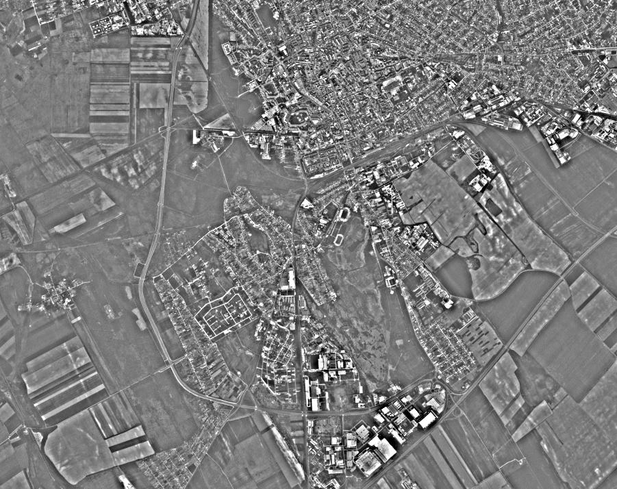
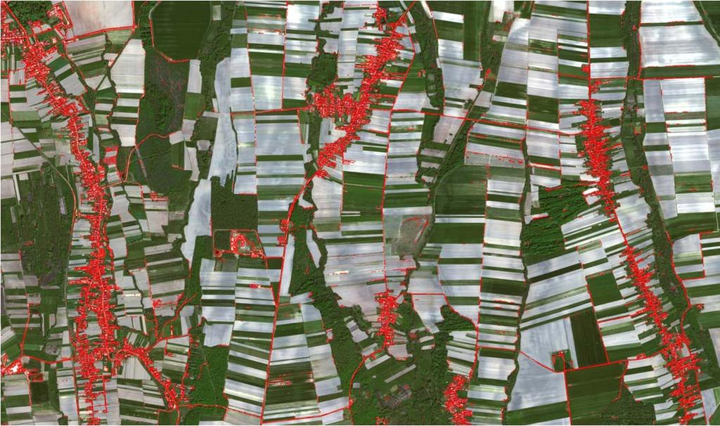
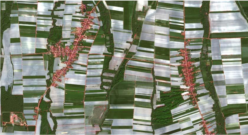
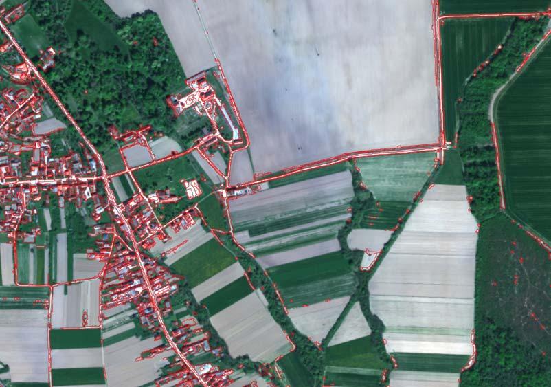
1 1 Detecting artificial areas inside reference parcels. A technique to assist the evaluation of non-eligibility in agriculture R. de Kok, C.Wirnhardt EC Joint Research Centre, IES Motivation Wall-to-wall seasonal coverage has become possible. Does it offer a basis to think about additional analysis or alternatives? Visual interpretation > 0.2 e6 polygons is not a solution. Now, wall-to-wall is at 5 meters but what if it becomes 50 cm? 2 source: 1
2 3 Topics in sequence; Automatic analysis needs one master rule set using transferable feature attributes. Contrast is such a feature attribute, applicable for; adjacent, large and very large neighborhoods. What kind of polygon population will be screened.(farmers block, eligible land, declared parcel). Single mosaic classification is insufficient, multi-stage might be necessary Cost per square KM² is a guideline. Main focus remains on anomalies in agriculture 4 NDVI-- Vegetation Index Based on physical properties; Absorption in Red, Reflection in Infrared Contrast-xxx -- Build up Index (cf. Pesaresi et.al. 2008) Could be based on; Shadow casting, an adjacent feature (on local neighborhood)? Self-repeatability, a proximity feature? ( Pesaresi, M.,Gerhardinger, A. Kayitakire F. 2008; A robust built-up area presence index by anisotropic rotation-invariant textural measure, IEEE Journal. of sel. top. in app. EO and RS, Vol 1. No. 3 Sept 2008) 2

3 5 CONTRAST, Complexity reduction and information preservation 6 CONTRAST, Can be formalized From : de Kok, R. and Taşdemir, K., Analysis of high-resolution remote sensing imagery with textures derived from single pixel objects. SPIE Remote Sensing Conference 8181, Earth Resources and Environmental Remote Sensing/GIS Applications, September, Prague. 3


4 7 dist=1 d=10 OBIA contrast allows experiments on large and very large neighborhoods From a (Binary) Value to a Value-Range 100g g d=50 d=
5 9 d =1 10 d =25 5


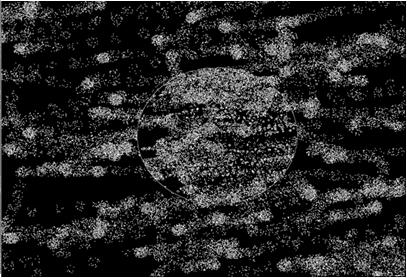
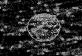
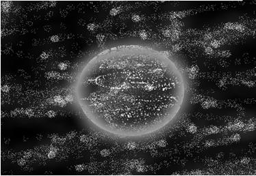
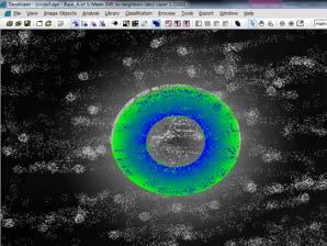
6 11 d =100 the Sinkhole Effect 12 RapidEye Red-Band 6

7 17th GeoCAP Tallinn MARS unit 17th GeoCAP Tallinn MARS unit d =25 7


8 e6 Polygons 35 out of 255 Tiles 80 hours processing 16 8
9


10 17th GeoCAP Tallinn MARS unit 17th GeoCAP Tallinn MARS unit Switching from Parcels to 250 Meter blocks. It does change statistics but not remote sensing results. 10


11 21 Detecting spatial clustering is an option 22 11


12 23 24 Source; DMC_II 12


13 25 1 Year Ago 26 13
14
15
16 31 Additional data Multi-stage classification becomes a necessity in order to remove commission failures, especially in textural vegetation detection. The spectral features in a RapidEye single mosaic causes trouble in classifying the tiled-imagery using a single master-process, due to large seasonal differences in the tiles. This influence is limited for artificial surfaces and they are therefore the first candidate to test the production time and protocol conditions. As an alternative to the development of more advanced classification techniques, the choice for extra (cheap) data allows to diminish this problem. Adding additional 5 to 15 meter Red and Infrared information to the mosaic of RapidEye certainly solves a lot of classification failures. The choice is the budget. What is a reasonable price per KM²? Conclusions: 32 o Extension of the search radius allows for a zonal definition. o Shadow is important to explain contrast for adjacent neighborhood but larger neighborhood contrast is more complex. o The extended context (self similar) defines the response to contrast over larger and very large neighborhoods, producing for example the sinkhole effect o The strategy aims at reducing the omission failures. This favors commission failures which require additional data. As long as additional cheap data is not available, the search for a better classifier remains. o OBIA contrast for single pixel objects has a modest effect on overall classification but is promising for special classes (artificial surfaces). o OBIA single pixel pre-processing also allow to exclude pixels from further segmentation and keep the single pixel information available at the lowest level (density, relative area, number of..etc.) 16
Classification in Image processing: A Survey
 Classification in Image processing: A Survey Rashmi R V, Sheela Sridhar Department of computer science and Engineering, B.N.M.I.T, Bangalore-560070 Department of computer science and Engineering, B.N.M.I.T,
Managing and Monitoring Intertidal Oyster Reefs with Remote Sensing in Coastal South Carolina
 Managing and Monitoring Intertidal Oyster Reefs with Remote Sensing in Coastal South Carolina A cooperative effort between: Coastal Services Center South Carolina Department of Natural Resources City of
AUTOMATIC DETECTION OF HEDGES AND ORCHARDS USING VERY HIGH SPATIAL RESOLUTION IMAGERY
 AUTOMATIC DETECTION OF HEDGES AND ORCHARDS USING VERY HIGH SPATIAL RESOLUTION IMAGERY Selim Aksoy Department of Computer Engineering, Bilkent University, Bilkent, 06800, Ankara, Turkey saksoy@cs.bilkent.edu.tr
APCAS/10/21 April 2010 ASIA AND PACIFIC COMMISSION ON AGRICULTURAL STATISTICS TWENTY-THIRD SESSION. Siem Reap, Cambodia, April 2010
 APCAS/10/21 April 2010 Agenda Item 8 ASIA AND PACIFIC COMMISSION ON AGRICULTURAL STATISTICS TWENTY-THIRD SESSION Siem Reap, Cambodia, 26-30 April 2010 The Use of Remote Sensing for Area Estimation by Robert
Quantifying Change in. Quality Effects on a. Wetland Extent & Wetland. Western and Clark s Grebe Breeding Population
 Quantifying Change in Wetland Extent & Wetland Quality Effects on a Western and Clark s Grebe Breeding Population Eagle Lake, CA: 1998-2010 Renée E. Robison 1, Daniel W. Anderson 2,3, and Kristofer M.
Crop area estimates in the EU. The use of area frame surveys and remote sensing
 INRA Rabat, October 14,. 2011 1 Crop area estimates in the EU. The use of area frame surveys and remote sensing Javier.gallego@jrc.ec.europa.eu Main approaches to agricultural statistics INRA Rabat, October
Digitization of Trail Network Using Remotely-Sensed Data in the CFB Suffield National Wildlife Area
 Digitization of Trail Network Using Remotely-Sensed Data in the CFB Suffield National Wildlife Area Brent Smith DLE 5-5 and Mike Tulis G3 GIS Technician Department of National Defence 27 March 2007 Introduction
Introduction to Remote Sensing Fundamentals of Satellite Remote Sensing. Mads Olander Rasmussen
 Introduction to Remote Sensing Fundamentals of Satellite Remote Sensing Mads Olander Rasmussen (mora@dhi-gras.com) 01. Introduction to Remote Sensing DHI What is remote sensing? the art, science, and technology
Detecting Land Cover Changes by extracting features and using SVM supervised classification
 Detecting Land Cover Changes by extracting features and using SVM supervised classification ABSTRACT Mohammad Mahdi Mohebali MSc (RS & GIS) Shahid Beheshti Student mo.mohebali@gmail.com Ali Akbar Matkan,
Preparing for the exploitation of Sentinel-2 data for agriculture monitoring. JACQUES Damien, DEFOURNY Pierre UCL-Geomatics Lab 2 octobre 2013
 Preparing for the exploitation of Sentinel-2 data for agriculture monitoring JACQUES Damien, DEFOURNY Pierre UCL-Geomatics Lab 2 octobre 2013 Agriculture monitoring, why? - Growing speculation on food
Caatinga - Appendix. Collection 3. Version 1. General coordinator Washington J. S. Franca Rocha (UEFS)
") Caatinga - Appendix Collection 3 Version 1 General coordinator Washington J. S. Franca Rocha (UEFS) Team Diego Pereira Costa (UEFS/GEODATIN) Frans Pareyn (APNE) José Luiz Vieira (APNE) Rodrigo N. Vasconcelos
Caatinga - Appendix Collection 3 Version 1 General coordinator Washington J. S. Franca Rocha (UEFS) Team Diego Pereira Costa (UEFS/GEODATIN) Frans Pareyn (APNE) José Luiz Vieira (APNE) Rodrigo N. Vasconcelos
Morphological Building/Shadow Index for Building Extraction From High-Resolution Imagery Over Urban Areas
 IEEE JOURNAL OF SELECTED TOPICS IN APPLIED EARTH OBSERVATIONS AND REMOTE SENSING, VOL. 5, NO. 1, FEBRUARY 2012 161 Morphological Building/Shadow Index for Building Extraction From High-Resolution Imagery
Remote Sensing. The following figure is grey scale display of SPOT Panchromatic without stretching.
 Remote Sensing Objectives This unit will briefly explain display of remote sensing image, geometric correction, spatial enhancement, spectral enhancement and classification of remote sensing image. At
White Paper. Medium Resolution Images and Clutter From Landsat 7 Sources. Pierre Missud
 White Paper Medium Resolution Images and Clutter From Landsat 7 Sources Pierre Missud Medium Resolution Images and Clutter From Landsat7 Sources Page 2 of 5 Introduction Space technologies have long been
Geocoding DoubleCheck: A Unique Location Accuracy Assessment Tool for Parcel-level Geocoding
 Measuring, Modelling and Mapping our Dynamic Home Planet Geocoding DoubleCheck: A Unique Location Accuracy Assessment Tool for Parcel-level Geocoding Page 1 Geocoding is a process of converting an address
Activity Data (AD) Monitoring in the frame of REDD+ MRV
 Monitoring in the frame of REDD+ MRV") Activity Data (AD) Monitoring in the frame of REDD+ MRV Preliminary comments REDD+ is sustainable low emissions, high carbon rural development Monitoring efforts should support this effort Challenges Diversity
Activity Data (AD) Monitoring in the frame of REDD+ MRV Preliminary comments REDD+ is sustainable low emissions, high carbon rural development Monitoring efforts should support this effort Challenges Diversity
University of Texas at San Antonio EES 5053 Term Project CORRELATION BETWEEN NDVI AND SURFACE TEMPERATURES USING LANDSAT ETM + IMAGERY NEWFEL MAZARI
 University of Texas at San Antonio EES 5053 Term Project CORRELATION BETWEEN NDVI AND SURFACE TEMPERATURES USING LANDSAT ETM + IMAGERY NEWFEL MAZARI Introduction and Objectives The present study is a correlation
GeoBase Raw Imagery Data Product Specifications. Edition
 GeoBase Raw Imagery 2005-2010 Data Product Specifications Edition 1.0 2009-10-01 Government of Canada Natural Resources Canada Centre for Topographic Information 2144 King Street West, suite 010 Sherbrooke,
ERDAS IMAGINE Suite Comparison
 ERDAS Suite Comparison A brief comparison of Essentials, Advantage and Professional age 1 of 7 Overview This document provides a brief comparison of the main features and capabilities found within the
Remote sensing in archaeology from optical to lidar. Krištof Oštir ModeLTER Scientific Research Centre of the Slovenian Academy of Sciences and Arts
 Remote sensing in archaeology from optical to lidar Krištof Oštir ModeLTER Scientific Research Centre of the Slovenian Academy of Sciences and Arts Introduction Optical remote sensing Systems Search for
Advanced Techniques in Urban Remote Sensing
 Advanced Techniques in Urban Remote Sensing Manfred Ehlers Institute for Geoinformatics and Remote Sensing (IGF) University of Osnabrueck, Germany mehlers@igf.uni-osnabrueck.de Contents Urban Remote Sensing:
Textural analysis of coca plantations using 1-meter-resolution remotely-sensed data
 UNODC Workshop, 25-28 November, Bogota, Colombia 1 Textural analysis of coca plantations using 1-meter-resolution remotely-sensed data Workshop on Measurement of Cultivation and Production of Coca Leaves
Detection of Compound Structures in Very High Spatial Resolution Images
 Detection of Compound Structures in Very High Spatial Resolution Images Selim Aksoy Department of Computer Engineering Bilkent University Bilkent, 06800, Ankara, Turkey saksoy@cs.bilkent.edu.tr Joint work
IKONOS High Resolution Multispectral Scanner Sensor Characteristics
 High Spatial Resolution and Hyperspectral Scanners IKONOS High Resolution Multispectral Scanner Sensor Characteristics Launch Date View Angle Orbit 24 September 1999 Vandenberg Air Force Base, California,
Digital Image Classification for Monitoring Landcover
 Digital Image Classification for Monitoring Landcover Trainer Khaled Mashfiq 2 / April / 2018 Training Module A1 Session 2 Advanced Application of Geospatial Information technology for Decision Support
Urban Feature Classification Technique from RGB Data using Sequential Methods
 Urban Feature Classification Technique from RGB Data using Sequential Methods Hassan Elhifnawy Civil Engineering Department Military Technical College Cairo, Egypt Abstract- This research produces a fully
Image interpretation and analysis
 Image interpretation and analysis Grundlagen Fernerkundung, Geo 123.1, FS 2014 Lecture 7a Rogier de Jong Michael Schaepman Why are snow, foam, and clouds white? Why are snow, foam, and clouds white? Today
Spectral compatibility of vegetation indices across sensors: band decomposition analysis with Hyperion data
 Journal of Applied Remote Sensing, Vol. 4, 043520 (30 March 2010) Spectral compatibility of vegetation indices across sensors: band decomposition analysis with Hyperion data Youngwook Kim,a Alfredo R.
Remote Sensing. Odyssey 7 Jun 2012 Benjamin Post
 Remote Sensing Odyssey 7 Jun 2012 Benjamin Post Definitions Applications Physics Image Processing Classifiers Ancillary Data Data Sources Related Concepts Outline Big Picture Definitions Remote Sensing
Satellite data processing and analysis: Examples and practical considerations
 Satellite data processing and analysis: Examples and practical considerations Dániel Kristóf Ottó Petrik, Róbert Pataki, András Kolesár International LCLUC Regional Science Meeting in Central Europe Sopron,
NON UNIFORM BACKGROUND REMOVAL FOR PARTICLE ANALYSIS BASED ON MORPHOLOGICAL STRUCTURING ELEMENT:
 IJCE January-June 2012, Volume 4, Number 1 pp. 59 67 NON UNIFORM BACKGROUND REMOVAL FOR PARTICLE ANALYSIS BASED ON MORPHOLOGICAL STRUCTURING ELEMENT: A COMPARATIVE STUDY Prabhdeep Singh1 & A. K. Garg2
Preparing Remote Sensing Data for Natural Resources Mapping (image enhancement, rectifications )
") Preparing Remote Sensing Data for Natural Resources Mapping (image enhancement, rectifications ) Why is this important What are the major approaches Examples of digital image enhancement Follow up exercises
Preparing Remote Sensing Data for Natural Resources Mapping (image enhancement, rectifications ) Why is this important What are the major approaches Examples of digital image enhancement Follow up exercises
Michigan Technological University. Characterization of Unpaved Road Condition Through the Use of Remote Sensing
 Michigan Technological University Characterization of Unpaved Road Condition Through the Use of Remote Sensing Deliverable 6-A: A Demonstration Mission Planning System for use in Remote Sensing the Phenomena
LPIS Orthoimagery An assessment of the Bing imagery for LPIS purpose
 LPIS Orthoimagery An assessment of the Bing imagery for LPIS purpose Slavko Lemajić Wim Devos, Pavel Milenov GeoCAP Action - MARS Unit - JRC Ispra Tallinn, 24 th November 2011 Outline JRC`s Ortho specifications
Urban Land-use Classification Using Variogram-based Analysis with an Aerial Photograph
 Urban Land-use Classification Using Variogram-based Analysis with an Aerial Photograph Shuo-sheng Wu, Bing Xu, and Le Wang Abstract In this study, a variogram-based texture analysis was tested for classifying
Lesson 9: Multitemporal Analysis
 Lesson 9: Multitemporal Analysis Lesson Description Multitemporal change analyses require the identification of features and measurement of their change through time. In this lesson, we will examine vegetation
IACS Conference Ghent May Looking back on a season of workshops and meetings on RS
 IACS Conference Ghent 29-31 May 2017 Looking back on a season of workshops and meetings on RS Looking back at a season full of RS activities Prague Brussels Amsterdam Learning Network Panta Rhei Malta
How to Access Imagery and Carry Out Remote Sensing Analysis Using Landsat Data in a Browser
 How to Access Imagery and Carry Out Remote Sensing Analysis Using Landsat Data in a Browser Including Introduction to Remote Sensing Concepts Based on: igett Remote Sensing Concept Modules and GeoTech
AUTOMATED STAND DELINEATION AND FIRE FUELS MAPPING
 AUTOMATED STAND DELINEATION AND FIRE FUELS MAPPING Jennifer Stefanacci, Director of Geospatial Services Parallel, Incorporated USGS Rocky Mountain Geographic Science Center Denver, CO 80225 jlstefanacci@usgs.gov
Spatial Analyst is an extension in ArcGIS specially designed for working with raster data.
 Spatial Analyst is an extension in ArcGIS specially designed for working with raster data. 1 Do you remember the difference between vector and raster data in GIS? 2 In Lesson 2 you learned about the difference
CLASSIFICATION OF VEGETATION AREA FROM SATELLITE IMAGES USING IMAGE PROCESSING TECHNIQUES ABSTRACT
 CLASSIFICATION OF VEGETATION AREA FROM SATELLITE IMAGES USING IMAGE PROCESSING TECHNIQUES Arpita Pandya Research Scholar, Computer Science, Rai University, Ahmedabad Dr. Priya R. Swaminarayan Professor
DISTINGUISHING URBAN BUILT-UP AND BARE SOIL FEATURES FROM LANDSAT 8 OLI IMAGERY USING DIFFERENT DEVELOPED BAND INDICES
 DISTINGUISHING URBAN BUILT-UP AND BARE SOIL FEATURES FROM LANDSAT 8 OLI IMAGERY USING DIFFERENT DEVELOPED BAND INDICES Mark Daryl C. Janiola (1), Jigg L. Pelayo (1), John Louis J. Gacad (1) (1) Central
EXAMPLES OF OBJECT-ORIENTED CLASSIFICATION PERFORMED ON HIGH-RESOLUTION SATELLITE IMAGES
 EXAMPLES OF OBJECT-ORIENTED CLASSIFICATION... 349 Stanisław Lewiński, Karol Zaremski EXAMPLES OF OBJECT-ORIENTED CLASSIFICATION PERFORMED ON HIGH-RESOLUTION SATELLITE IMAGES Abstract: Information about
Atlantic Forest - Appendix
 Atlantic Forest - Appendix Collection 3 Version 1 General coordinator Marcos Reis Rosa Team Fernando Frizeira Paternost Jacqueline Freitas Viviane Cristina Mazin Eduardo Reis Rosa 1 Landsat image mosaics
Keywords: Agriculture, Olive Trees, Supervised Classification, Landsat TM, QuickBird, Remote Sensing.
 Classification of agricultural fields by using Landsat TM and QuickBird sensors. The case study of olive trees in Lesvos island. Christos Vasilakos, University of the Aegean, Department of Environmental
large area By Juan Felipe Villegas E Scientific Colloquium Forest information technology
 A comparison of three different Land use classification methods based on high resolution satellite images to find an appropriate methodology to be applied on a large area By Juan Felipe Villegas E Scientific
A MULTISTAGE APPROACH FOR DETECTING AND CORRECTING SHADOWS IN QUICKBIRD IMAGERY
 A MULTISTAGE APPROACH FOR DETECTING AND CORRECTING SHADOWS IN QUICKBIRD IMAGERY Jindong Wu, Assistant Professor Department of Geography California State University, Fullerton 800 North State College Boulevard
USE OF DIGITAL AERIAL IMAGES TO DETECT DAMAGES DUE TO EARTHQUAKES
 USE OF DIGITAL AERIAL IMAGES TO DETECT DAMAGES DUE TO EARTHQUAKES Fumio Yamazaki 1, Daisuke Suzuki 2 and Yoshihisa Maruyama 3 ABSTRACT : 1 Professor, Department of Urban Environment Systems, Chiba University,
Lecture 19: Depth Cameras. Kayvon Fatahalian CMU : Graphics and Imaging Architectures (Fall 2011)
") Lecture 19: Depth Cameras Kayvon Fatahalian CMU 15-869: Graphics and Imaging Architectures (Fall 2011) Continuing theme: computational photography Cheap cameras capture light, extensive processing produces
Lecture 19: Depth Cameras Kayvon Fatahalian CMU 15-869: Graphics and Imaging Architectures (Fall 2011) Continuing theme: computational photography Cheap cameras capture light, extensive processing produces
GROßFLÄCHIGE UND HOCHFREQUENTE BEOBACHTUNG VON AGRARFLÄCHEN DURCH OPTISCHE SATELLITEN (RAPIDEYE, LANDSAT 8, SENTINEL-2)
") GROßFLÄCHIGE UND HOCHFREQUENTE BEOBACHTUNG VON AGRARFLÄCHEN DURCH OPTISCHE SATELLITEN (RAPIDEYE, LANDSAT 8, SENTINEL-2) Karsten Frotscher Produktmanager Landwirtschaft Slide 1 A Couple Of Words About The
GROßFLÄCHIGE UND HOCHFREQUENTE BEOBACHTUNG VON AGRARFLÄCHEN DURCH OPTISCHE SATELLITEN (RAPIDEYE, LANDSAT 8, SENTINEL-2) Karsten Frotscher Produktmanager Landwirtschaft Slide 1 A Couple Of Words About The
GE 113 REMOTE SENSING
 GE 113 REMOTE SENSING Topic 8. Image Classification and Accuracy Assessment Lecturer: Engr. Jojene R. Santillan jrsantillan@carsu.edu.ph Division of Geodetic Engineering College of Engineering and Information
In late April of 1986 a nuclear accident damaged a reactor at the Chernobyl nuclear
 CHERNOBYL NUCLEAR POWER PLANT ACCIDENT Long Term Effects on Land Use Patterns Project Introduction: In late April of 1986 a nuclear accident damaged a reactor at the Chernobyl nuclear power plant in Ukraine.
CHARACTERISTICS OF REMOTELY SENSED IMAGERY. Spatial Resolution
 CHARACTERISTICS OF REMOTELY SENSED IMAGERY Spatial Resolution There are a number of ways in which images can differ. One set of important differences relate to the various resolutions that images express.
Aerial Image Acquisition and Processing Services. Ron Coutts, M.Sc., P.Eng. RemTech, October 15, 2014
 Aerial Image Acquisition and Processing Services Ron Coutts, M.Sc., P.Eng. RemTech, October 15, 2014 Outline Applications & Benefits Image Sources Aircraft Platforms Image Products Sample Images & Comparisons
GST 101: Introduction to Geospatial Technology Lab Series. Lab 6: Understanding Remote Sensing and Aerial Photography
 GST 101: Introduction to Geospatial Technology Lab Series Lab 6: Understanding Remote Sensing and Aerial Photography Document Version: 2013-07-30 Organization: Del Mar College Author: Richard Smith Copyright
Seasonal Progression of the Normalized Difference Vegetation Index (NDVI)
") Seasonal Progression of the Normalized Difference Vegetation Index (NDVI) For this exercise you will be using a series of six SPOT 4 images to look at the phenological cycle of a crop. The images are SPOT
Seasonal Progression of the Normalized Difference Vegetation Index (NDVI) For this exercise you will be using a series of six SPOT 4 images to look at the phenological cycle of a crop. The images are SPOT
Visualizing a Pixel. Simulate a Sensor s View from Space. In this activity, you will:
 Simulate a Sensor s View from Space In this activity, you will: Measure and mark pixel boundaries Learn about spatial resolution, pixels, and satellite imagery Classify land cover types Gain exposure to
PILOTING A DECISION SUPPORT TOOL (DST) FOR MAPPING CYANOBACTERIAL HARMFUL ALGAL BLOOMS (CHABS) TO SUPPORT PUBLIC HEALTH AND RESOURCE MANAGEMENT.
 FOR MAPPING CYANOBACTERIAL HARMFUL ALGAL BLOOMS (CHABS) TO SUPPORT PUBLIC HEALTH AND RESOURCE MANAGEMENT.") PILOTING A DECISION SUPPORT TOOL (DST) FOR MAPPING CYANOBACTERIAL HARMFUL ALGAL BLOOMS (CHABS) TO SUPPORT PUBLIC HEALTH AND RESOURCE MANAGEMENT. Nathan Torbick, Applied Geosolutions Scott Stoodley, Director,
PILOTING A DECISION SUPPORT TOOL (DST) FOR MAPPING CYANOBACTERIAL HARMFUL ALGAL BLOOMS (CHABS) TO SUPPORT PUBLIC HEALTH AND RESOURCE MANAGEMENT. Nathan Torbick, Applied Geosolutions Scott Stoodley, Director,
Urban Classification of Metro Manila for Seismic Risk Assessment using Satellite Images
 Urban Classification of Metro Manila for Seismic Risk Assessment using Satellite Images Fumio YAMAZAKI/ yamazaki@edm.bosai.go.jp Hajime MITOMI/ mitomi@edm.bosai.go.jp Yalkun YUSUF/ yalkun@edm.bosai.go.jp
An NDVI image provides critical crop information that is not visible in an RGB or NIR image of the same scene. For example, plants may appear green
 Normalized Difference Vegetation Index (NDVI) Spectral Band calculation that uses the visible (RGB) and near-infrared (NIR) bands of the electromagnetic spectrum NDVI= + An NDVI image provides critical
SUGARCANE CROP EXTRACTION USING OBJECT-ORIENTED METHOD FROM ZY- 3 HIGH RESOLUTION SATELLITE TLC IMAGE
 SUGARCANE CROP EXTRACTION USING OBJECT-ORIENTED METHOD FROM ZY- 3 HIGH RESOLUTION SATELLITE TLC IMAGE H. Luo 1,2,3, Z.Y. Ling 1,2,3, *, G.Z. Shao 1,2,3, Y. Huang 1,2,3, Y.Q. He 1, W.Y. Ning 1,2,3, Z. Zhong
Documenting Land Cover and Vegetation Productivity Changes in the NWT using the Landsat Satellite Archive
 Documenting Land Cover and Vegetation Productivity Changes in the NWT using the Landsat Satellite Archive Fraser, R.H 1, Olthof, I. 1, Deschamps, A. 1, Pregitzer, M. 1, Kokelj, S. 2, Lantz, T. 3,Wolfe,
Background Adaptive Band Selection in a Fixed Filter System
 Background Adaptive Band Selection in a Fixed Filter System Frank J. Crosby, Harold Suiter Naval Surface Warfare Center, Coastal Systems Station, Panama City, FL 32407 ABSTRACT An automated band selection
Center for Advanced Land Management Information Technologies (CALMIT), School of Natural Resources, University of Nebraska-Lincoln
, School of Natural Resources, University of Nebraska-Lincoln") Geoffrey M. Henebry, Andrés Viña, and Anatoly A. Gitelson Center for Advanced Land Management Information Technologies (CALMIT), School of Natural Resources, University of Nebraska-Lincoln Introduction
Geoffrey M. Henebry, Andrés Viña, and Anatoly A. Gitelson Center for Advanced Land Management Information Technologies (CALMIT), School of Natural Resources, University of Nebraska-Lincoln Introduction
OBJECT-BASED FOREST CHANGE DETECTION USING HIGH RESOLUTION SATELLITE IMAGES
 In: Stilla U et al (Eds) PIA11. International Archives of Photogrammetry, Remote Sensing and Spatial Information Sciences 38 (3/W22) OBJECT-BASED FOREST CHANGE DETECTION USING HIGH RESOLUTION SATELLITE
Using Multi-spectral Imagery in MapInfo Pro Advanced
 Using Multi-spectral Imagery in MapInfo Pro Advanced MapInfo Pro Advanced Tom Probert, Global Product Manager MapInfo Pro Advanced: Intuitive interface for using multi-spectral / hyper-spectral imagery
Radar Imagery Filtering with Use of the Mathematical Morphology Operations
 From the SelectedWorks of Przemysław Kupidura 2008 Radar Imagery Filtering with Use of the Mathematical Morphology Operations Przemysław Kupidura Piotr Koza Available at: https://works.bepress.com/przemyslaw_kupidura/7/
LANDSLIDE MAPPING USING IMAGERY ACQUIRED BY A FIXED-WING UAV
 LANDSLIDE MAPPING USING IMAGERY ACQUIRED BY A FIXED-WING UAV J. Y. Rau a J. P. Jhan a, C. F. Lo b, Y. S. Lin b a Department of Geomatics, National Cheng Kung University, Tainan City 701, Taiwan jyrau@mail.ncku.edu.tw,
Land Cover Analysis to Determine Areas of Clear-cut and Forest Cover in Olney, Montana. Geob 373 Remote Sensing. Dr Andreas Varhola, Kathry De Rego
 1 Land Cover Analysis to Determine Areas of Clear-cut and Forest Cover in Olney, Montana Geob 373 Remote Sensing Dr Andreas Varhola, Kathry De Rego Zhu an Lim (14292149) L2B 17 Apr 2016 2 Abstract Montana
1. PHOTO ESSAY THE GREENING OF DETROIT, : PHYSICAL EFFECTS OF DECLINE
 1. PHOTO ESSAY THE GREENING OF DETROIT, 1975-1992: PHYSICAL EFFECTS OF DECLINE John D. Nystuen, The University of Michigan Rhonda Ryznar, The University of Michigan Thomas Wagner, Environmental Research
Automatic Morphological Segmentation and Region Growing Method of Diagnosing Medical Images
 International Journal of Information & Computation Technology. ISSN 0974-2239 Volume 2, Number 3 (2012), pp. 173-180 International Research Publications House http://www. irphouse.com Automatic Morphological
Stochastic Screens Robust to Mis- Registration in Multi-Pass Printing
 Published as: G. Sharma, S. Wang, and Z. Fan, "Stochastic Screens robust to misregistration in multi-pass printing," Proc. SPIE: Color Imaging: Processing, Hard Copy, and Applications IX, vol. 5293, San
University of Technology Building & Construction Department / Remote Sensing & GIS lecture
 8. Image Enhancement 8.1 Image Reduction and Magnification. 8.2 Transects (Spatial Profile) 8.3 Spectral Profile 8.4 Contrast Enhancement 8.4.1 Linear Contrast Enhancement 8.4.2 Non-Linear Contrast Enhancement
Crop Area Estimation with Remote Sensing
 Boogta 25-28 November 2008 1 Crop Area Estimation with Remote Sensing Some considerations and experiences for the application to general agricultural statistics Javier.gallego@jrc.it Some history: MARS
The techniques with ERDAS IMAGINE include:
 The techniques with ERDAS IMAGINE include: 1. Data correction - radiometric and geometric correction 2. Radiometric enhancement - enhancing images based on the values of individual pixels 3. Spatial enhancement
Automatic Vehicles Detection from High Resolution Satellite Imagery Using Morphological Neural Networks
 Automatic Vehicles Detection from High Resolution Satellite Imagery Using Morphological Neural Networks HONG ZHENG Research Center for Intelligent Image Processing and Analysis School of Electronic Information
Interpreting land surface features. SWAC module 3
 Interpreting land surface features SWAC module 3 Interpreting land surface features SWAC module 3 Different kinds of image Panchromatic image True-color image False-color image EMR : NASA Echo the bat
University of Wisconsin-Madison, Nelson Institute for Environmental Studies September 2, 2014
 University of Wisconsin-Madison, Nelson Institute for Environmental Studies September 2, 2014 The Earth from Above Introduction to Environmental Remote Sensing Lectures: Tuesday, Thursday 2:30-3:45 pm,
Coastal areas and land development. An algorithm for monitoring informal constructions An application in coastal areas. Informal building in Greece
 An algorithm for monitoring informal constructions An application in coastal areas Ch. Psaltis, Ch. Ioannidis Coastal areas and land development Coastal areas more developed than continental areas Overconcentration
Satellite Imagery and Remote Sensing. DeeDee Whitaker SW Guilford High EES & Chemistry
 Satellite Imagery and Remote Sensing DeeDee Whitaker SW Guilford High EES & Chemistry whitakd@gcsnc.com Outline What is remote sensing? How does remote sensing work? What role does the electromagnetic
Land Cover Type Changes Related to. Oil and Natural Gas Drill Sites in a. Selected Area of Williams County, ND
 Land Cover Type Changes Related to Oil and Natural Gas Drill Sites in a Selected Area of Williams County, ND FR 3262/5262 Lab Section 2 By: Andrew Kernan Tyler Kaebisch Introduction: In recent years, there
High resolution satellite imagery a shared and collective data source
 High resolution satellite imagery a shared and collective data source Jean-Philippe Cantou IGN France EFGS forum - Helsinki 16-18 october 2018 1 / 25 ign.fr IGN duties Produce and update the large scale
Efficient Target Detection from Hyperspectral Images Based On Removal of Signal Independent and Signal Dependent Noise
 IOSR Journal of Electronics and Communication Engineering (IOSR-JECE) e-issn: 2278-2834,p- ISSN: 2278-8735.Volume 9, Issue 6, Ver. III (Nov - Dec. 2014), PP 45-49 Efficient Target Detection from Hyperspectral
Removing Thick Clouds in Landsat Images
 Removing Thick Clouds in Landsat Images S. Brindha, S. Archana, V. Divya, S. Manoshruthy & R. Priya Dept. of Electronics and Communication Engineering, Avinashilingam Institute for Home Science and Higher
Enhancement of Multispectral Images and Vegetation Indices
 Enhancement of Multispectral Images and Vegetation Indices ERDAS Imagine 2016 Description: We will use ERDAS Imagine with multispectral images to learn how an image can be enhanced for better interpretation.
GE 113 REMOTE SENSING. Topic 7. Image Enhancement
 GE 113 REMOTE SENSING Topic 7. Image Enhancement Lecturer: Engr. Jojene R. Santillan jrsantillan@carsu.edu.ph Division of Geodetic Engineering College of Engineering and Information Technology Caraga State
NEW ATMOSPHERIC CORRECTION METHOD BASED ON BAND RATIOING
 NEW ATMOSPHERIC CORRECTION METHOD BASED ON BAND RATIOING DEPARTMENT OF PHYSICS/COLLEGE OF EDUCATION FOR GIRLS, UNIVERSITY OF KUFA, AL-NAJAF,IRAQ hussienalmusawi@yahoo.com ABSTRACT The Atmosphere plays
High Resolution Multi-spectral Imagery
 High Resolution Multi-spectral Imagery Jim Baily, AirAgronomics AIRAGRONOMICS Having been involved in broadacre agriculture until 2000 I perceived a need for a high resolution remote sensing service to
IMPROVEMENT IN THE DETECTION OF LAND COVER CLASSES USING THE WORLDVIEW-2 IMAGERY
 IMPROVEMENT IN THE DETECTION OF LAND COVER CLASSES USING THE WORLDVIEW-2 IMAGERY Ahmed Elsharkawy 1,2, Mohamed Elhabiby 1,3 & Naser El-Sheimy 1,4 1 Dept. of Geomatics Engineering, University of Calgary
NORMALIZING ASTER DATA USING MODIS PRODUCTS FOR LAND COVER CLASSIFICATION
 NORMALIZING ASTER DATA USING MODIS PRODUCTS FOR LAND COVER CLASSIFICATION F. Gao a, b, *, J. G. Masek a a Biospheric Sciences Branch, NASA Goddard Space Flight Center, Greenbelt, MD 20771, USA b Earth
Road Network Extraction and Recognition Using Color
 Road Network Extraction and Recognition Using Color Clustering From Color Map Images Zhang Lulu 1, He Ning,Xu Cheng 3 Beijing Key Laboratory of Information Service Engineer Information Institute,Beijing
MULTI-TEMPORAL SATELLITE IMAGES WITH BATHYMETRY CORRECTION FOR MAPPING AND ASSESSING SEAGRASS BED CHANGES IN DONGSHA ATOLL
 MULTI-TEMPORAL SATELLITE IMAGES WITH BATHYMETRY CORRECTION FOR MAPPING AND ASSESSING SEAGRASS BED CHANGES IN DONGSHA ATOLL Chih -Yuan Lin and Hsuan Ren Center for Space and Remote Sensing Research, National
Introduction to Remote Sensing
 Introduction to Remote Sensing Daniel McInerney Urban Institute Ireland, University College Dublin, Richview Campus, Clonskeagh Drive, Dublin 14. 16th June 2009 Presentation Outline 1 2 Spaceborne Sensors
Sommersemester Prof. Dr. Christoph Kleinn Institut für Waldinventur und Waldwachstum Arbeitsbereich Fernerkundung und Waldinventur.
 Basics of Remote Sensing Some literature references Franklin, SE 2001 Remote Sensing for Sustainable Forest Management Lewis Publishers 407p Lillesand, Kiefer 2000 Remote Sensing and Image Interpretation
A COMPARISON OF COVERTYPE DELINEATIONS FROM AUTOMATED IMAGE SEGMENTATION OF INDEPENDENT AND MERGED IRS AND LANDSAT TM IMAGE-BASED DATA SETS
 A COMPARISON OF COVERTYPE DELINEATIONS FROM AUTOMATED IMAGE SEGMENTATION OF INDEPENDENT AND MERGED IRS AND LANDSAT TM IMAGE-BASED DATA SETS M. Riley, Space Imaging Solutions USDA Forest Service, Region
Malaria Vector in Northeastern Venezuela. Sarah Anne Guagliardo MPH candidate, 2010 Yale University School of Epidemiology and Public Health
 Vegetation associated with the An. Aquasalis Malaria Vector in Northeastern Venezuela Sarah Anne Guagliardo g MPH candidate, 2010 Yale University School of Epidemiology and Public Health Outline Problem
APPLIED MACHINE VISION IN AGRICULTURE AT THE NCEA. C.L. McCarthy and J. Billingsley
 APPLIED MACHINE VISION IN AGRICULTURE AT THE NCEA C.L. McCarthy and J. Billingsley National Centre for Engineering in Agriculture (NCEA), USQ, Toowoomba, QLD, Australia ABSTRACT Machine vision involves
Introduction to WG5 on CwRS imagery use and alternatives and QE5 on claimed rate inside the RP Peter Viskum Jørgensen, FERV and Birger Faurholt
 Introduction to WG5 on CwRS imagery use and alternatives and QE5 on claimed rate inside the RP Peter Viskum Jørgensen, FERV and Birger Faurholt Pedersen, University of Aarhus, DK CwRS Imagery use and alternatives
Dirty REMOTE SENSING Lecture 3: First Steps in classifying Stuart Green Earthobservation.wordpress.com
 Dirty REMOTE SENSING Lecture 3: First Steps in classifying Stuart Green Earthobservation.wordpress.com Stuart.Green@Teagasc.ie You have your image, but is it any good? Is it full of cloud? Is it the right
Acquisition of Aerial Photographs and/or Satellite Imagery
 Acquisition of Aerial Photographs and/or Satellite Imagery Acquisition of Aerial Photographs and/or Imagery From time to time there is considerable interest in the purchase of special-purpose photography