GROßFLÄCHIGE UND HOCHFREQUENTE BEOBACHTUNG VON AGRARFLÄCHEN DURCH OPTISCHE SATELLITEN (RAPIDEYE, LANDSAT 8, SENTINEL-2)
|
|
|
- Julianna Bennett
- 5 years ago
- Views:
Transcription
 Karsten Frotscher Produktmanager Landwirtschaft Slide")
1 GROßFLÄCHIGE UND HOCHFREQUENTE BEOBACHTUNG VON AGRARFLÄCHEN DURCH OPTISCHE SATELLITEN (RAPIDEYE, LANDSAT 8, SENTINEL-2) Karsten Frotscher Produktmanager Landwirtschaft Slide 1

2 A Couple Of Words About The Latest Headlines BlackBridge is now part of the Planet Labs family Slide 2


3 The Challenges Slide 3
4 When You Need to Manage Fields You Want Information about your fields several times during the growing season Enough in-field detail Cost-effectiveness A reliable source of information available over large areas Slide 4

5 So That at The End of The Day You Can... Help your customers make better decisions for better field management Optimize input costs Increase yield Farm sustainability Slide 5


6 Getting a Regular Picture of Your Fields May Aug Jun Jul 22, 08, 17, 26, 15, 10, 2013 Slide 6

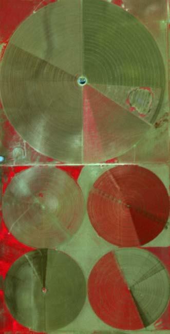
7 Enough In-field Detail to Monitor Variability Slide 7


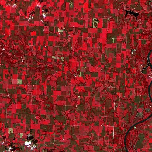
8 But When You Need to Cover Large Areas Slide 8

9 Slide 9
10 Can Satellite Imagery Take Care of All That? Broad coverage In-season revisit In-field detail Cost-effectiveness Slide 10
11 The Monitoring Solution Slide 11


12 Monitoring Program Features BROAD COVERAGE IN-SEASON REVISIT IN-FIELD DETAIL QUICK & EASY DATA MANAGEMENT + Major agricultural areas worldwide + Daily acquisition within AOI + Typically one image per month + 5 meter ortho + 5 spectral bands + High positional accuracy + API + GUI + Colocation MULTI-YEAR ARCHIVE + 7 years of archived RapidEye imagery + Co-registered Landsat 8 imagery + Sentinel-2 imagery Slide 12

13 Imagery Products RAPIDEYE ORTHO PRODUCT 3A + 5 m pixel size + 5 spectral bands + 25 x 25 km tile size + GeoTiff Download LANDSAT-8 L1T CO-REGISTERED + 30 m MS Bands + 15 m Pan Bands + TIRS + In Program AOIs + Co-registered w/ RE + GeoTiff Download SENTINEL-2 Slide 13


14 RapidEye & Landsat 8 (& Sentinel-2) Increased Reliability Improved Inter- Usability Before RapidEye L3A NIR, Red, Green meter 16 bit unsigned BlackBridge After Landsat 8 L1T NIR, Red, Green meter 16 bit unsigned USGS North Slide 14

15 Slide 15


16 Broad Coverage - North America Example Scalable Daily coverage Month 1 coverage Reliable + Month 2 coverage Easily Accessible + Month 3 coverage + Month 4 coverage RapidEye Image Takes RapidEye Ortho Products Landsat 8 Scenes Cropland Percentage (Source: IIASA) BlackBridge November 6, 2015 Slide 16

17 Multi-Year Archive - North America Example Archive Period: 15 th of May to 15 th of September for each year Slide 18


18 In-Season Revisit 25 x 25 km L3A tile footprint Monthly coverage Additional coverage Specification: 20% clouds or less May 20 Jun 20 Jul 3 Jul 14 Jul 19 Jul 26 Aug 14 Aug 18 Sep 7 Sep 15 Slide 19


19 In-Season Revisit 25 x 25 km L3A tile footprint Monthly coverage Additional coverage Specification: 20% clouds or less Jun 1 Jun 14 Jun 22 Jun 28 Jul 7 Jul 13 Aug 3 Aug 23 Sep 02 Sep 10 Slide 20


20 In-Field Detail - Color-Infrared (CIR) CIR Imagery Scout for Problems Analyze Growth Stage Monitor Crop Health Write Prescriptions Jun 1 Jun 14 Jun 22 Jun 28 Jul 7 Jul 13 Aug 3 Aug 23 Sep 02 Sep 10 Slide 21


21 Use Case Vegetation Index Jun 1 Jun 14 Jun 22 Jun 28 Jul 7 Jul 13 Aug 3 Aug 23 Sep 02 Sep 10 Slide 22


22 Use Case Vegetation Index CIR Imagery Alfalfa Alfalfa Corn Vegetation Index Onion Corn Potato Scout for Problems Analyze Growth Stage Monitor Crop Health Carrots Potato Potato Onion Onion Carrots Onion Corn Potato Potato Alfalfa Alfalfa Triticale Corn Write Prescriptions Potato Corn Potato Corn Potato Onion Jun Aug Sep 6 10 Jul 2014 BlackBridge Alfalfa Potato Onion Potato Spring Wheat Morrow County, Oregon November 6, 2015 Slide 23


23 Use Case Persistent Productivity Zones Composite Slide 24
24 In-Field Status and Variability Imagery is used to delineate management zones and for decision support: Variable rate fertilization application Detection of water issues and irrigation needs Variable rate application of pesticides Damage assessment Slide 25
 Slide")
25 Monitoring Programs Worldwide Existing Programs Program in Development Cropland Percentage (Source: IIASA) Slide 26


26 Quick and Easy Data Management Slide 27
27 Easy Imagery Access Imagery is cloud hosted and accessible via: 1. Dedicated web app for users 2. REST API for programmatic access Search all imagery from YOUR subscription Access all from YOUR Subscription Slide 28

28 Easy Imagery Access REST API Programmatic query and retrieval of imagery Full metadata search Ideal for custom workflows and automated processes. Slide 29

29 Cloud-Based Co-location Deploy your workflows on VMs next to the data: Instant data no download latency Access to scalable compute resources More than 3 times faster archive queries More than 20 times faster image downloads Slide 30


30 RapidEye Data Distribution Slide 31


31 Main Benefits Large-area collection Multiple in-season coverage Field-level detail Quick and easy access Cost-effectiveness Slide 32


32 Danke! Slide 33
PLANET IMAGERY PRODUCT SPECIFICATIONS PLANET.COM
 PLANET IMAGERY PRODUCT SPECIFICATIONS SUPPORT@PLANET.COM PLANET.COM LAST UPDATED JANUARY 2018 TABLE OF CONTENTS LIST OF FIGURES 3 LIST OF TABLES 4 GLOSSARY 5 1. OVERVIEW OF DOCUMENT 7 1.1 Company Overview
PLANET: IMAGING THE EARTH EVERY DAY
 PLANET: IMAGING THE EARTH EVERY DAY Benjamin Trigona-Harany Mailiao Refinery, Taiwan May 31, 2016 To image the whole world every day, making change visible, accessible and actionable. HONG KONG January
Planet Labs Inc 2017 Page 2
 SKYSAT IMAGERY PRODUCT SPECIFICATION: ORTHO SCENE LAST UPDATED JUNE 2017 SALES@PLANET.COM PLANET.COM Disclaimer This document is designed as a general guideline for customers interested in acquiring Planet
Determining the green vegetation fraction from RapidEye data for use in regional climate simulations
 Research Unit 1695 Determining the green vegetation fraction from RapidEye data for use in regional climate simulations Kristina Imukova, Joachim Ingwersen and Thilo Streck Institute of Soil Science and
PLANET SURFACE REFLECTANCE PRODUCT
 PLANET SURFACE REFLECTANCE PRODUCT FEBRUARY 2018 SUPPORT@PLANET.COM PLANET.COM VERSION 1.0 TABLE OF CONTENTS 3 Product Description 3 Atmospheric Correction Methodology 5 Product Limitations 6 Product Assessment
Lab 1 Introduction to ENVI
 Remote sensing for agricultural applications: principles and methods (2013-2014) Instructor: Prof. Tao Cheng (tcheng@njau.edu.cn) Nanjing Agricultural University Lab 1 Introduction to ENVI April 1 st,
Inter-Calibration of the RapidEye Sensors with Landsat 8, Sentinel and SPOT
 Inter-Calibration of the RapidEye Sensors with Landsat 8, Sentinel and SPOT Dr. Andreas Brunn, Dr. Horst Weichelt, Dr. Rene Griesbach, Dr. Pablo Rosso Content About Planet Project Context (Purpose and
SDCG-5 Session 2. Landsat 7/8 status and 2013 Implementation Plan (Element 1)
") Session 2 Landsat 7/8 status and 2013 Implementation Plan (Element 1) Gene Fosnight Mission Landsat Launch and commissioning Landsat 7 Operational: since 15 April 1999 Expected life time:; anticipate decommissioning
Session 2 Landsat 7/8 status and 2013 Implementation Plan (Element 1) Gene Fosnight Mission Landsat Launch and commissioning Landsat 7 Operational: since 15 April 1999 Expected life time:; anticipate decommissioning
Field size estimation, past and future opportunities
 Field size estimation, past and future opportunities Lin Yan & David Roy Geospatial Sciences Center of Excellence South Dakota State University February 13-15 th 2018 Advances in Emerging Technologies
Preparing for the exploitation of Sentinel-2 data for agriculture monitoring. JACQUES Damien, DEFOURNY Pierre UCL-Geomatics Lab 2 octobre 2013
 Preparing for the exploitation of Sentinel-2 data for agriculture monitoring JACQUES Damien, DEFOURNY Pierre UCL-Geomatics Lab 2 octobre 2013 Agriculture monitoring, why? - Growing speculation on food
Satellite Remote Sensing: Earth System Observations
 Satellite Remote Sensing: Earth System Observations Land surface Water Atmosphere Climate Ecosystems 1 EOS (Earth Observing System) Develop an understanding of the total Earth system, and the effects of
The Landsat Legacy: Monitoring a Changing Earth. U.S. Department of the Interior U.S. Geological Survey
 The Landsat Legacy: Monitoring a Changing Earth U.S. Department of the Interior U.S. Geological Survey Tom Loveland March 17, 2001 Landsat Science Mission Change is occurring at rates unprecedented in
Can Satellite Image Analysis Replace Manual Digitization?
 Can Satellite Image Analysis Replace Manual Digitization? GeoDATA London 30 th Nov 2017 LUCY KENNEDY Spottitt CEO Lucy.Kennedy@spottitt.com +44 772 594 4643 Agenda Why develop processes and services based
An NDVI image provides critical crop information that is not visible in an RGB or NIR image of the same scene. For example, plants may appear green
 Normalized Difference Vegetation Index (NDVI) Spectral Band calculation that uses the visible (RGB) and near-infrared (NIR) bands of the electromagnetic spectrum NDVI= + An NDVI image provides critical
USGS Welcome. 38 th CEOS Working Group on Calibration and Validation Plenary (WGCV-38)
") Landsat 5 USGS Welcome Prepared for 38 th CEOS Working Group on Calibration and Validation Plenary (WGCV-38) Presenter Tom Cecere International Liaison USGS Land Remote Sensing Program Elephant Butte Reservoir
Landsat 5 USGS Welcome Prepared for 38 th CEOS Working Group on Calibration and Validation Plenary (WGCV-38) Presenter Tom Cecere International Liaison USGS Land Remote Sensing Program Elephant Butte Reservoir
NASA Missions and Products: Update. Garik Gutman, LCLUC Program Manager NASA Headquarters Washington, DC
 NASA Missions and Products: Update Garik Gutman, LCLUC Program Manager NASA Headquarters Washington, DC 1 JPSS-2 (NOAA) SLI-TBD Formulation in 2015 RBI OMPS-Limb [[TSIS-2]] [[TCTE]] Land Monitoring at
NON-PHOTOGRAPHIC SYSTEMS: Multispectral Scanners Medium and coarse resolution sensor comparisons: Landsat, SPOT, AVHRR and MODIS
 NON-PHOTOGRAPHIC SYSTEMS: Multispectral Scanners Medium and coarse resolution sensor comparisons: Landsat, SPOT, AVHRR and MODIS CLASSIFICATION OF NONPHOTOGRAPHIC REMOTE SENSORS PASSIVE ACTIVE DIGITAL
Land Cover Type Changes Related to. Oil and Natural Gas Drill Sites in a. Selected Area of Williams County, ND
 Land Cover Type Changes Related to Oil and Natural Gas Drill Sites in a Selected Area of Williams County, ND FR 3262/5262 Lab Section 2 By: Andrew Kernan Tyler Kaebisch Introduction: In recent years, there
Rapideye (2008 -> ) Not just another high resolution satellite sensor. 5 satellites RapidEye constellation. 5 million km² daily collection capacity
 Not just another high resolution satellite sensor. 5 satellites RapidEye constellation. 5 million km² daily collection capacity") Rapideye (2008 -> ) Not just another high resolution satellite sensor 5 satellites RapidEye constellation 5 million km² daily collection capacity Price: $1.40 / sq km ($2.50 rectified) Orbit: http://www.youtube.com/watch?feature=player_embedded&v=ovpulctoqgs
Rapideye (2008 -> ) Not just another high resolution satellite sensor 5 satellites RapidEye constellation 5 million km² daily collection capacity Price: $1.40 / sq km ($2.50 rectified) Orbit: http://www.youtube.com/watch?feature=player_embedded&v=ovpulctoqgs
Standing Up NAIP and Landsat Image Services as a Processing Resource. Andrew Leason
 Standing Up NAIP and Landsat Image Services as a Processing Resource Andrew Leason NAIP and Landsat services Differences Different general uses - Landsat - Available from USGS - Designed as an analytical
PLANET IMAGERY PRODUCT SPECIFICATION: PLANETSCOPE & RAPIDEYE
 PLANET IMAGERY PRODUCT SPECIFICATION: PLANETSCOPE & RAPIDEYE LAST UPDATED OCTOBER 2016 SALES@PLANET.COM PLANET.COM Table of Contents LIST OF FIGURES 3 LIST OF TABLES 3 GLOSSARY 5 1. OVERVIEW OF DOCUMENT
Using Freely Available. Remote Sensing to Create a More Powerful GIS
 Using Freely Available Government Data and Remote Sensing to Create a More Powerful GIS All rights reserved. ENVI, E3De, IAS, and IDL are trademarks of Exelis, Inc. All other marks are the property of
Lecture 6: Multispectral Earth Resource Satellites. The University at Albany Fall 2018 Geography and Planning
 Lecture 6: Multispectral Earth Resource Satellites The University at Albany Fall 2018 Geography and Planning Outline SPOT program and other moderate resolution systems High resolution satellite systems
Please show the instructor your downloaded index files and orthoimages.
 Student Exercise 1: Sandia Forest Infestation Acquiring Orthophotos and Satellite Imagery Please show the instructor your downloaded index files and orthoimages. Objectives: Determine appropriate imagery
FUSION User Workshop
 FUSION User Workshop FUSION High Resolution Land Monitoring by Fusion of Optical and Infrared Data Normal temperature applications such as agricultural monitoring Lilit Kocharyan, RapidEye AG Gefördert
Using Web-based Tools for GIS-Friendly Satellite Imagery
 Using Web-based Tools for GIS-Friendly Satellite Imagery Lindsey Harriman SGT, Contractor to the USGS EROS Center, Sioux Falls, South Dakota **Work performed under USGS contract G10PC00044 U.S. Department
Data Warehouse Phase 2 CORE Datasets Status 15 th May 2018
 Data Warehouse Phase 2 CORE Datasets Status 15 th May 2018 The document presents the status of the open CORE datasets, for which data provision is on-going. Once closed, content of the datasets can be
Lesson 3: Working with Landsat Data
 Lesson 3: Working with Landsat Data Lesson Description The Landsat Program is the longest-running and most extensive collection of satellite imagery for Earth. These datasets are global in scale, continuously
Downloading Imagery & LIDAR
 Downloading Imagery & LIDAR 333 Earth Explorer The USGS is a great source for downloading many different GIS data products for the entire US and Canada and much of the world. Below are instructions for
Satellite data processing and analysis: Examples and practical considerations
 Satellite data processing and analysis: Examples and practical considerations Dániel Kristóf Ottó Petrik, Róbert Pataki, András Kolesár International LCLUC Regional Science Meeting in Central Europe Sopron,
CORN BEST MANAGEMENT PRACTICES CHAPTER 22. Matching Remote Sensing to Problems
 CORN BEST MANAGEMENT PRACTICES CHAPTER 22 USDA photo by Regis Lefebure Matching Remote Sensing to Problems Jiyul Chang (Jiyul.Chang@sdstate.edu) and David Clay (David.Clay@sdstate.edu) Remote sensing can
The Utility and Limitations of Remote Sensing in Land Use Change Detection and Conservation Planning
 The Utility and Limitations of Remote Sensing in Land Use Change Detection and Conservation Planning Steffen Mueller, PhD, Principal Economist Ken Copenhaver, CropGrower LLC Presentation to: US Environmental
PLANET IMAGERY PRODUCT SPECIFICATION: PLANETSCOPE & RAPIDEYE
 PLANET IMAGERY PRODUCT SPECIFICATION: PLANETSCOPE & RAPIDEYE LAST UPDATED FEBRUARY 2017 SALES@PLANET.COM PLANET.COM Table of Contents LIST OF FIGURES 3 LIST OF TABLES 3 GLOSSARY 5 1. OVERVIEW OF DOCUMENT
Valuable New Information for Precision Agriculture. Mike Ritter Founder & CEO - SLANTRANGE, Inc.
 Valuable New Information for Precision Agriculture Mike Ritter Founder & CEO - SLANTRANGE, Inc. SENSORS Accurate, Platform- Agnostic ANALYTICS On-Board, On-Location SLANTRANGE Delivering Valuable New Information
Global hot spot monitoring with Landsat 8 and Sentinel-2. Soushi Kato Atsushi Oda Ryosuke Nakamura (AIST)
") Global hot spot monitoring with Landsat 8 and Sentinel-2 Soushi Kato Atsushi Oda Ryosuke Nakamura (AIST) Motivation for Detecting Hot Spots Hotspot detection using satellite data To monitor wildfire and
Global hot spot monitoring with Landsat 8 and Sentinel-2 Soushi Kato Atsushi Oda Ryosuke Nakamura (AIST) Motivation for Detecting Hot Spots Hotspot detection using satellite data To monitor wildfire and
Summary. Introduction. Remote Sensing Basics. Selecting a Remote Sensing Product
 K. Dalsted, J.F. Paris, D.E. Clay, S.A. Clay, C.L. Reese, and J. Chang SSMG-40 Selecting the Appropriate Satellite Remote Sensing Product for Precision Farming Summary Given the large number of satellite
29 th Annual Louisiana RS/GIS Workshop April 23, 2013 Cajundome Convention Center Lafayette, Louisiana
 Landsat Data Continuity Mission 29 th Annual Louisiana RS/GIS Workshop April 23, 2013 Cajundome Convention Center Lafayette, Louisiana http://landsat.usgs.gov/index.php# Landsat 5 Sets Guinness World Record
Use of Remote Sensing to Characterize Impervious Cover in Stormwater Impaired Watersheds
 University of Massachusetts Amherst ScholarWorks@UMass Amherst Water Resources Research Center Conferences Water Resources Research Center 4-9-2007 Use of Remote Sensing to Characterize Impervious Cover
Lecture 7 Earth observation missions
 Remote sensing for agricultural applications: principles and methods (2013-2014) Instructor: Prof. Tao Cheng (tcheng@njau.edu.cn). Nanjing Agricultural University Lecture 7 Earth observation missions May
Activity Data (AD) Monitoring in the frame of REDD+ MRV
 Monitoring in the frame of REDD+ MRV") Activity Data (AD) Monitoring in the frame of REDD+ MRV Preliminary comments REDD+ is sustainable low emissions, high carbon rural development Monitoring efforts should support this effort Challenges Diversity
Activity Data (AD) Monitoring in the frame of REDD+ MRV Preliminary comments REDD+ is sustainable low emissions, high carbon rural development Monitoring efforts should support this effort Challenges Diversity
Data Requirements Definition and Data Services Options for RAPP
 Data Requirements Definition and Data Services Options for RAPP Brian Killough CEOS Systems Engineering Office (SEO) 5 th GEOGLAM RAPP Workshop Frascati, Italy May 16-17, 2017 Requirements Update The observation
NORMALIZING ASTER DATA USING MODIS PRODUCTS FOR LAND COVER CLASSIFICATION
 NORMALIZING ASTER DATA USING MODIS PRODUCTS FOR LAND COVER CLASSIFICATION F. Gao a, b, *, J. G. Masek a a Biospheric Sciences Branch, NASA Goddard Space Flight Center, Greenbelt, MD 20771, USA b Earth
News on Image Acquisition for the CwRS Campaign new sensors and changes
 Control Methods Workshop: 6-8 / 4 / 2009 [CwRS KO Meeting Campaign 2009] 1 News on Image Acquisition for the CwRS Campaign 2009 - new sensors and changes Pär Johan Åstrand, Joanna Nowak, Maria Erlandsson
Capture the invisible
 Capture the invisible A Capture the invisible The Sequoia multispectral sensor captures both visible and invisible images, providing calibrated data to optimally monitor the health and vigor of your crops.
Introduction to Remote Sensing Fundamentals of Satellite Remote Sensing. Mads Olander Rasmussen
 Introduction to Remote Sensing Fundamentals of Satellite Remote Sensing Mads Olander Rasmussen (mora@dhi-gras.com) 01. Introduction to Remote Sensing DHI What is remote sensing? the art, science, and technology
How to Access Imagery and Carry Out Remote Sensing Analysis Using Landsat Data in a Browser
 How to Access Imagery and Carry Out Remote Sensing Analysis Using Landsat Data in a Browser Including Introduction to Remote Sensing Concepts Based on: igett Remote Sensing Concept Modules and GeoTech
Using Multi-spectral Imagery in MapInfo Pro Advanced
 Using Multi-spectral Imagery in MapInfo Pro Advanced MapInfo Pro Advanced Tom Probert, Global Product Manager MapInfo Pro Advanced: Intuitive interface for using multi-spectral / hyper-spectral imagery
Sentinel-2 Products and Algorithms
 Sentinel-2 Products and Algorithms Ferran Gascon (Sentinel-2 Data Quality Manager) Workshop Preparations for Sentinel 2 in Europe, Oslo 26 November 2014 Sentinel-2 Mission Mission Overview Products and
Pléiades. Access to data. Charlotte Gabriel-Robez. January Pléiades product manager
 Pléiades Access to data Charlotte Gabriel-Robez Pléiades product manager January 2012 A variety of users 2008: Delegation of Public Service Granted by CNES to Spot Image Astrium Services (ex. Spot Image)
PILOTING A DECISION SUPPORT TOOL (DST) FOR MAPPING CYANOBACTERIAL HARMFUL ALGAL BLOOMS (CHABS) TO SUPPORT PUBLIC HEALTH AND RESOURCE MANAGEMENT.
 FOR MAPPING CYANOBACTERIAL HARMFUL ALGAL BLOOMS (CHABS) TO SUPPORT PUBLIC HEALTH AND RESOURCE MANAGEMENT.") PILOTING A DECISION SUPPORT TOOL (DST) FOR MAPPING CYANOBACTERIAL HARMFUL ALGAL BLOOMS (CHABS) TO SUPPORT PUBLIC HEALTH AND RESOURCE MANAGEMENT. Nathan Torbick, Applied Geosolutions Scott Stoodley, Director,
PILOTING A DECISION SUPPORT TOOL (DST) FOR MAPPING CYANOBACTERIAL HARMFUL ALGAL BLOOMS (CHABS) TO SUPPORT PUBLIC HEALTH AND RESOURCE MANAGEMENT. Nathan Torbick, Applied Geosolutions Scott Stoodley, Director,
MULTI-TEMPORAL LAND-COVER CLASSIFICATION APPROACH WITH NEW RAPIDEYE IMAGE DATA
 Proceedings of the 2 nd Workshop of the EARSeL SIG on Land Use and Land Cover MULTI-TEMPORAL LAND-COVER CLASSIFICATION APPROACH WITH NEW RAPIDEYE IMAGE DATA Urs Schulthess, Horst Weichelt, Stefanie Grundner,
Future US Land Imaging. Harmonized Landsat/Sentinel-2 (HLS) Project
 Project") Future US Land Imaging Jeffrey Masek, NASA GSFC Harmonized Landsat/Sentinel-2 (HLS) Project Jeff Masek, Junchang Ju, Eric Vermote, NASA GSFC Martin NASA Agency Claverie, Update Jean-Claude CEOS Roger,
Future US Land Imaging Jeffrey Masek, NASA GSFC Harmonized Landsat/Sentinel-2 (HLS) Project Jeff Masek, Junchang Ju, Eric Vermote, NASA GSFC Martin NASA Agency Claverie, Update Jean-Claude CEOS Roger,
EnMAP Environmental Mapping and Analysis Program
 EnMAP Environmental Mapping and Analysis Program www.enmap.org Mathias Schneider Mission Objectives Regular provision of high-quality calibrated hyperspectral data Precise measurement of ecosystem parameters
Not just another high resolution satellite sensor
 Global Forest Change Published by Hansen, Potapov, Moore, Hancher et al. http://earthenginepartners.appspot.com/science-2013-global-forest Rapideye Not just another high resolution satellite sensor 5 satellites
Landsat 8 and Sentinel 2 higher order products: input to S2DUP. Chris Justice (UMD) Curtis Woodcock (BU), Martin Claverie (UMD/GSFC)
 Curtis Woodcock (BU), Martin Claverie (UMD/GSFC)") Landsat 8 and Sentinel 2 higher order products: input to S2DUP Chris Justice (UMD) Curtis Woodcock (BU), Martin Claverie (UMD/GSFC) MODIS Land Products Energy Balance Product Suite Surface Reflectance
Landsat 8 and Sentinel 2 higher order products: input to S2DUP Chris Justice (UMD) Curtis Woodcock (BU), Martin Claverie (UMD/GSFC) MODIS Land Products Energy Balance Product Suite Surface Reflectance
The use of satellite images to forecast agricultural
 The use of satellite images to forecast agricultural Luxembourg, 12.03.2014 r. Tomasz Milewski NUTS for Poland: NUTS 1 macro-regions (grup of province, voivodships) (6), NUTS 2 - regions (province,
Grant Boxer Consultant Geologist March 10th 2014 (Updated Nov 2014)
") Grant Boxer Consultant Geologist March 10th 2014 (Updated Nov 2014) Work flow for Landsat 8 Landgate Data Selecting and processing basic data Importing into MapInfo Applications SLIP Portal WMS access
Grant Boxer Consultant Geologist March 10th 2014 (Updated Nov 2014) Work flow for Landsat 8 Landgate Data Selecting and processing basic data Importing into MapInfo Applications SLIP Portal WMS access
Remote sensing in FIGARO
 FIGARO FLEXIBLE AND PRECISE IRRIGATION PLATFORM TO IMPROVE FARM SCALE WATER PRODUCTIVITY Remote sensing in FIGARO Final Meeting, Brussels 19/09/2016 Technical University of Valencia Use of Remote sensing
JECAM Guidelines: Definition of the Minimum Earth Observation Dataset Requirements
 JECAM Guidelines: Definition of the Minimum Earth Observation Dataset Requirements This document is version 1.0 of the JECAM minimum dataset requirements. It has been prepared based on 20 JECAM site reports,
E m e r g e n c y M a n a g e m e n t S e r v i c e. C o p e r n i c u s A e r i a l c o m p o n e n t s t a t u s s t u d y
 E m e r g e n c y M a n a g e m e n t S e r v i c e C o p e r n i c u s A e r i a l c o m p o n e n t s t a t u s s t u d y Peter Spruyt European Commission Joint Research Centre EMS Mapping User Workshop
Update on Landsat Program and Landsat Data Continuity Mission
 Update on Landsat Program and Landsat Data Continuity Mission Dr. Jeffrey Masek LDCM Deputy Project Scientist NASA GSFC, Code 923 November 21, 2002 Draft LDCM Implementation Phase RFP Overview Page 1 Celebrate!
The studies began when the Tiros satellites (1960) provided man s first synoptic view of the Earth s weather systems.
 provided man s first synoptic view of the Earth s weather systems.") Remote sensing of the Earth from orbital altitudes was recognized in the mid-1960 s as a potential technique for obtaining information important for the effective use and conservation of natural resources.
Remote sensing of the Earth from orbital altitudes was recognized in the mid-1960 s as a potential technique for obtaining information important for the effective use and conservation of natural resources.
GMES DA COPERNICUS
 2014 Airbus Defence and Space All rights reserved. The reproduction, distribution and utilization of this document as well as the communication of its contents to others without express authorization is
WGISS-42 USGS Agency Report
 WGISS-42 USGS Agency Report U.S. Department of the Interior U.S. Geological Survey Kristi Kline USGS EROS Center Major Activities Landsat Archive/Distribution Changes Land Change Monitoring, Assessment,
Google Earth Engine Image Pre-processing Tool: User guide
 Google Earth Engine Image Pre-processing Tool: Lukas Würsch, Kaspar Hurni, and Andreas Heinimann Centre for Development and Environment (CDE) University of Bern 2017 Introduction The image pre-processing
MULTISPECTRAL AGRICULTURAL ASSESSMENT. Normalized Difference Vegetation Index. Federal Robotics INSPECTION & DOCUMENTATION
 MULTISPECTRAL AGRICULTURAL ASSESSMENT Normalized Difference Vegetation Index INSPECTION & DOCUMENTATION Federal Robotics Clearwater Dr. Amherst, New York 14228 716-221-4181 Sales@FedRobot.com www.fedrobot.com
Airbus Airbus Defence and Space - Intelligence. Price List North America
 Airbus Airbus Defence and Space - Intelligence Price List North America Effective: January 1, 2018 Pléiades and SPOT 1-7 Archive Prices are per square kilometer. Prices and minimum order size apply for
AN EVALUATION OF RESOURCESAT-1 LISS-III VERSUS AWIFS IMAGERY FOR IDENTIFYING CROPLANDS INTRODUCTION AND BACKGROUND
 AN EVALUATION OF RESOURCESAT-1 VERSUS AWIFS IMAGERY FOR IDENTIFYING CROPLANDS David M. Johnson, Geographer National Agricultural Statistics Service United States Department of Agriculture 3251 Old Lee
6th Beirut Water Week 27th February - 1st March 2017
 Assessment of chlorophyll-a concentration using Landsat Operational Land Imager in Lake Qaraoun, Lebanon Ali Fadel 6th Beirut Water Week 27th February - 1st March 2017 Introduction & problematic Worldwide
SUGAR_GIS. From a user perspective. Provides spatial distribution of a wide range of sugarcane production data in an easy to use and sensitive way.
 SUGAR_GIS From a user perspective What is Sugar_GIS? A web-based, decision support tool. Provides spatial distribution of a wide range of sugarcane production data in an easy to use and sensitive way.
Software requirements * : Part I: 1 hr. Part III: 2 hrs.
 Title: Product Type: Developer: Target audience: Format: Software requirements * : Data: Estimated time to complete: Using MODIS to Analyze the Seasonal Growing Cycle of Crops Part I: Understand and locate
DLR contribution and perspectives for JECAM
 DLR contribution and perspectives for JECAM Dr. Helmut Staudenrausch 1, Dr. Achim Roth 2 1 DLR Space Administration, Earth Observations helmut.staudenrausch@dlr.de 2 DLR, German Remote Sensing Data Center
Precision Remote Sensing and Image Processing for Precision Agriculture (PA)
") Precision Remote Sensing and Image Processing for Precision Agriculture (PA) Dr. Jack F. Paris Presented to Colorado State University, Fort Collins, CO October 20, 2005 Speaker s Current Activities: Consultant
Precision Remote Sensing and Image Processing for Precision Agriculture (PA) Dr. Jack F. Paris Presented to Colorado State University, Fort Collins, CO October 20, 2005 Speaker s Current Activities: Consultant
Robert Kevin Bohon Jr.
 COMPARING LANDSAT7 ETM+ AND NAIP IMAGERY FOR PRECISION AGRICULTURE APPLICATION IN SMALL SCALE FARMING: A CASE STUDY IN THE SOUTH EASTERN PART OF PITTSYLVANIA COUNTY, VA by Robert Kevin Bohon Jr. A Thesis
TechTime New Mapping Tools for Transportation Engineering
 GeoEye-1 Stereo Satellite Imagery Presented by Karl Kliparchuk, M.Sc., GISP kkliparchuk@mcelhanney.com 604-683-8521 All satellite imagery are copyright GeoEye Corp GeoEye-1 About GeoEye Corp Headquarters:
Crop and Irrigation Water Management Using High-resolution Airborne Remote Sensing
 Crop and Irrigation Water Management Using High-resolution Airborne Remote Sensing Christopher M. U. Neale and Hari Jayanthi Dept. of Biological and Irrigation Eng. Utah State University & James L.Wright
Imagery Archive Works
 USDA How Satellite the Imagery USDA s Archive Satellite Imagery Archive Works A. What is the USDA Satellite Imagery Archive? B. What are the benefits of participating in the USDA Archive? C. What types
SPOT4 (Take 5) time series over 45 sites to get ready for Sentinel-2
 time series over 45 sites to get ready for Sentinel-2") SPOT4 (Take 5) time series over 45 sites to get ready for Sentinel-2 O.Hagolle CESBIO/CNES ; S.Sylvander, CNES ; M.Huc, CESBIO/CNRS, D.Clesse, CAP GEMINI ; M.Leroy, CNES ; G.Dedieu, CESBIO/CNES ; J.Donadieu
SPOT4 (Take 5) time series over 45 sites to get ready for Sentinel-2 O.Hagolle CESBIO/CNES ; S.Sylvander, CNES ; M.Huc, CESBIO/CNRS, D.Clesse, CAP GEMINI ; M.Leroy, CNES ; G.Dedieu, CESBIO/CNES ; J.Donadieu
National Aeronautics and Space Administration. Landsat Update. Jeff Masek, NASA GSFC Jim Irons, NASA GSFC. April 3, 2012 LCLUC Meeting.
 National Aeronautics and Space Administration Landsat Update Jeff Masek, NASA GSFC Jim Irons, NASA GSFC April 3, 2012 LCLUC Meeting www.nasa.gov Agenda Landsat-5/7 Update LDCM / Landsat-8 Mission Status
ANALYSIS OF LAND COVER AND LAND USE CHANGES USING SENTINEL-2 IMAGES
 DOI 10.1515/pesd-2016-0034 PESD, VOL. 10, no. 2, 2016 ANALYSIS OF LAND COVER AND LAND USE CHANGES USING SENTINEL-2 IMAGES Nicoleta Iurist (Dumitrașcu) 1,, Florian Stătescu 2, Iustina Lateș 3 Key words,
Spectral Signatures. Vegetation. 40 Soil. Water WAVELENGTH (microns)
") Spectral Signatures % REFLECTANCE VISIBLE NEAR INFRARED Vegetation Soil Water.5. WAVELENGTH (microns). Spectral Reflectance of Urban Materials 5 Parking Lot 5 (5=5%) Reflectance 5 5 5 5 5 Wavelength (nm)
Spectral Signatures % REFLECTANCE VISIBLE NEAR INFRARED Vegetation Soil Water.5. WAVELENGTH (microns). Spectral Reflectance of Urban Materials 5 Parking Lot 5 (5=5%) Reflectance 5 5 5 5 5 Wavelength (nm)
European Space Imaging
 European Space Imaging Use cases of Very High Resolution satellite imagery in support of crop management GEO-CRADLE Regional Workshop, 7/12/2017, Tunis Arnaud Durand adurand@euspaceimaging.com COMPANY
PSW News. Landsat Analysis Ready Data (ARD) February 15, 2018 Volume 4 Issue 1
 February 15, 2018 Volume 4 Issue 1") February 15, 2018 Volume 4 Issue 1 Landsat Analysis Ready Data (ARD) By: Pete Coulter, PSW Region Director Inside This Issue Landsat Analysis Ready Data (ARD) 1 CalGIS 2018 / GIS-Pro Call for Participation
February 15, 2018 Volume 4 Issue 1 Landsat Analysis Ready Data (ARD) By: Pete Coulter, PSW Region Director Inside This Issue Landsat Analysis Ready Data (ARD) 1 CalGIS 2018 / GIS-Pro Call for Participation
Lecture 13: Remotely Sensed Geospatial Data
 Lecture 13: Remotely Sensed Geospatial Data A. The Electromagnetic Spectrum: The electromagnetic spectrum (Figure 1) indicates the different forms of radiation (or simply stated light) emitted by nature.
Downloading and formatting remote sensing imagery using GLOVIS
 Downloading and formatting remote sensing imagery using GLOVIS Students will become familiarized with the characteristics of LandSat, Aerial Photos, and ASTER medium resolution imagery through the USGS
Grade 3 Measurement and Data 3.MD.7a-d
 THE NEWARK PUBLIC SCHOOLS THE OFFICE OF MATHEMATICS Grade 3 Measurement and Data 3.MD.7a-d Student Pages 2012 COMMON CORE STATE STANDARDS ALIGNED MODULES Grade 3 - Lesson 1 Assessment Task Imagine that
Land Cover Analysis to Determine Areas of Clear-cut and Forest Cover in Olney, Montana. Geob 373 Remote Sensing. Dr Andreas Varhola, Kathry De Rego
 1 Land Cover Analysis to Determine Areas of Clear-cut and Forest Cover in Olney, Montana Geob 373 Remote Sensing Dr Andreas Varhola, Kathry De Rego Zhu an Lim (14292149) L2B 17 Apr 2016 2 Abstract Montana
White paper brief IdahoView Imagery Services: LISA 1 Technical Report no. 1 Processing and Evaluation
 White paper brief IdahoView Imagery Services: LISA 1 Technical Report no. 1 Processing and Evaluation Keith T. Weber, GISP, GIS Director, Idaho State University, 921 S. 8th Ave., stop 8104, Pocatello,
MAPS AND SATELLITE IMAGES TOOLS FOR AN EFFECTIVE MANAGEMENT OF THE HISTORIC CENTER OF SIGHISOARA, AN UNESCO WORLD HERITAGE SITE
 Journal of Young Scientist, Volume VI, 2018 ISSN 2344-1283; ISSN CD-ROM 2344-1291; ISSN Online 2344-1305; ISSN-L 2344 1283 MAPS AND SATELLITE IMAGES TOOLS FOR AN EFFECTIVE MANAGEMENT OF THE HISTORIC CENTER
Global Land Survey 2005
 Global Land Survey 2005 Jeff Masek, Shannon Franks, Terry Arvidson NASA GSFC Rachel Headley, Steve Covington USGS EROS April, 2008 1 Global Land Survey (GLS 2005) Follow-on to the GeoCover orthorectified
Introduction of Satellite Remote Sensing
 Introduction of Satellite Remote Sensing Spatial Resolution (Pixel size) Spectral Resolution (Bands) Resolutions of Remote Sensing 1. Spatial (what area and how detailed) 2. Spectral (what colors bands)
Managing Imagery and Raster Data. Peter Becker
 Managing Imagery and Raster Data Peter Becker ArcGIS is a Comprehensive Imagery Platform Empowering you to make informed decisions System of Engagement System of Insight Extract Information from Imagery
Monitoring of Mosul Reservoir Using Remote Sensing Techniques For the Period After ISIS Attack in 9 June Muthanna Mohammed Abdulhameed AL Bayati
 For the Period After ISIS Attack in 9 June 2014 Lecture: University of Technology Baghdad- Building and Construction Dept 1- Introduction The Mosul Dam is the fourth largest dam in the Middle East,(1)established
Sensor resolutions from space: the tension between temporal, spectral, spatial and swath. David Bruce UniSA and ISU
 Sensor resolutions from space: the tension between temporal, spectral, spatial and swath David Bruce UniSA and ISU 1 Presentation aims 1. Briefly summarize the different types of satellite image resolutions
9/12/2011. Training Course Remote Sensing Basic Theory & Image Processing Methods September 2011
 Training Course Remote Sensing Basic Theory & Image Processing Methods 19 23 September 2011 Popular Remote Sensing Sensors & their Selection Michiel Damen (September 2011) damen@itc.nl 1 Overview Low resolution
The availability of cloud free Landsat TM and ETM+ land observations and implications for global Landsat data production
 14475 The availability of cloud free Landsat TM and ETM+ land observations and implications for global Landsat data production *V. Kovalskyy, D. Roy (South Dakota State University) SUMMARY The NASA funded
Communicating Earth Observation (EO)-based landslide mapping capabilities to practitioners
-based landslide mapping capabilities to practitioners") Communicating Earth Observation (EO)-based landslide mapping capabilities to practitioners EGU 2016, Vienna, 18.04.2016 Florian Albrecht 1, Daniel Hölbling 1, Clemens Eisank 2, Elisabeth Weinke 1, Filippo
Communicating Earth Observation (EO)-based landslide mapping capabilities to practitioners EGU 2016, Vienna, 18.04.2016 Florian Albrecht 1, Daniel Hölbling 1, Clemens Eisank 2, Elisabeth Weinke 1, Filippo
European Space Imaging. Your Partner for Very High-Resolution Satellite Imagery GEOGRAPHIC
 European Space Imaging Your Partner for Very High-Resolution Satellite Imagery XVII International User Conference of GeoInformation Systems & Remote Sensing European Space Imaging Your Partner for Very
Land Remote Sensing Lab 4: Classication and Change Detection Assigned: October 15, 2017 Due: October 27, Classication
 Name: Land Remote Sensing Lab 4: Classication and Change Detection Assigned: October 15, 2017 Due: October 27, 2017 In this lab, you will generate several gures. Please sensibly name these images, save
Detecting artificial areas inside reference parcels. A technique to assist the evaluation of non-eligibility in agriculture
 1 Detecting artificial areas inside reference parcels. A technique to assist the evaluation of non-eligibility in agriculture R. de Kok, C.Wirnhardt EC Joint Research Centre, IES Motivation Wall-to-wall