Can Satellite Image Analysis Replace Manual Digitization?
|
|
|
- Meredith Hoover
- 5 years ago
- Views:
Transcription


1 Can Satellite Image Analysis Replace Manual Digitization? GeoDATA London 30 th Nov 2017 LUCY KENNEDY Spottitt CEO


2 Agenda Why develop processes and services based on satellite imagery? Traditional barriers to using satellite imagery and what is changing. What is possible in-terms of creating GIS data from satellite imagery?


3 Context For every 100MWatt of installed onshore wind power somebody has spent over 500,000 Euro and 6 months of manual effort just searching for sites with suitable geography using out of data maps and information. Could automation and satellite imagery be used to reduce cost and time to market of onshore wind developments? Thus in 2014 the concept of Automated and On Demand remote sensing analysis was born and 3 Spottitt co-founders started their journey. Thanks to European Space Agency co-funding July 2017 pre-commercial trails of the Spottitt service started with 8 customers.


4 Why consider satellite imagery? Lots has changed and is going to keep changing: Satellites becoming smaller and therefore cheaper to build and launch Single satellite to constellations Global coverage with high revisit frequency (Video) From single Competition satellitesdriving pricing and product spec. Open source and inter commercial providers To constellations Sputnik launched 4 Oct 1957 >1000 satellites >2000 satellites >3000 satellites

5 Why consider satellite imagery? Global coverage and resolution of data SPOT 1 revisit 1-4 days 20 meters 1986 IKONOS revisit 3-4 days 4 meters 1999 Geoeye meters 2008 Earth-i 3*per day <1 meter Colour video 2019 Landsat 1&2 18 days 80 meters 1972 Landsat 8 15 days 30 meters 2013 Sentinel days 10 meters 2015
")
6 Why consider satellite imagery? Similar picture for radar (SAR) satellite imagery
7 Traditional barriers? The buying process is complex and often very manual Online portals for search/purchase/download of imagery Growing number of image providers have APIs so you can seamlessly search, purchase and download imagery straight into your systems Still only a few services where you can search, purchase and download imagery from multiple commercial and non-commercial providers.


8 Traditional barriers? Commercial license agreements Competition and technical advancements forcing change Relaxing of many areas Creative business models


9 Traditional barriers? Just an expensive picture? Cloud computing Advanced image analysis techniques Automation


10 Spottitt Service Fully automated, cloud based, remote sensing analysis service, which allows customers to: select their desired automated analysis ranging from Land Cover Analysis through to Turbine Positioning analysis define their area of interest any where in the world purchase the most recent satellite imagery and data from multiple sources input their analysis parameters of choice e.g. minimum distance from buildings, roads etc. and get results in a matter of minutes/hours. Quick, efficient, affordable. No earth observation knowledge or software required.


11 Satellite versus aerial photography? 10s of centimetres 4-13 spectral bands Pre-processing required 0 14 per km 2 (40cm achieve imagery) Global coverage High revisit frequency = low prob. tasking required Centimetres Typically 4 bands Analysis ready 0-35 per km 2 (12.5 cm achieve imagery) Regional/national coverage Low revisit frequency = high prob. tasking required
 Complex rule based algorithms tailored to")
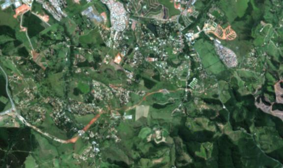
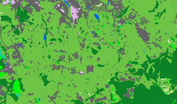
12 What is possible? Land Cover Analysis (Spottitt) Complex rule based algorithms tailored to renewables sector which provide 6m resolution LCA s anywhere in the world

13 What is possible? Feature match Wind turbines, storage tanks, (GeoVisual Search by Descartes Labs) AI used to find similar features all across America
 Neural")
14 What is possible? Feature extraction - Building recognition analysis(spottitt) Neural network trained on broad catalogue of global building types
")
15 What is possible? Forestry and agricultural insights (Global Surface Intelligence) Machine learning combined with high performance processing
 Multi input analysis of exclusion")
16 What is possible? Site selection (Spottitt) Multi input analysis of exclusion zones and buffers to determine suitable sites.

17 What is possible? Monitoring and change detection - Deforestation Time-lapse based on satellite imagery

18 What is possible? Monitoring and change detection Water depth (Proteus Geo) Satellite derived bathymetry


19 To answer the question? Can Satellite Image Analysis Replace Manual Digitization? But.it has an important role to play in the generation of valuable GIS products and services.


20 Spottitt Engage Follow our new LinkedIN page Goto and sign in as a demo user to have a play. Come and say hello at stand 36 Spottitt automation of complex EO and GIS analyses has numerous applications. Get in touch. Need automation and/or online delivery of a service you have developed: Maybe we can support you?
21

22 Spottitt - Contact Lucy Kennedy Lucy.Kennedy@spottitt.com Spottitt Ltd. Electron Building Fermi Avenue Harwell OX11 0QR UK info@spottitt.com Login to our geoportal as a demo user at View our European Space Agency project page -
KONGSBERG SATELLITE SERVICES 2017 Line Steinbakk, Director Programs. Himmel og hav - Ålesund 3. Oktober 2017
 KONGSBERG SATELLITE SERVICES 2017 Line Steinbakk, Director Programs Himmel og hav - Ålesund 3. Oktober 2017 KSAT HQ IN TROMSØ 69N Established in 1967 Kongsberg Satellite Services since 2002 World leading
Automated Damage Analysis from Overhead Imagery
 Automated Damage Analysis from Overhead Imagery EVAN JONES ANDRE COLEMAN SHARI MATZNER Pacific Northwest National Laboratory 1 PNNL FY2015 at a Glance $955 million in R&D expenditures 4,400 scientists,
The world s most advanced constellation
 The DigitalGlobe Constellation The world s most advanced constellation of very high-resolution satellites The world s most advanced constellation The DigitalGlobe constellation of high-resolution satellites
Earth Observations from Space U.S. Geological Survey
 Earth Observations from Space U.S. Geological Survey Geography Land Remote Sensing Program Dr. Bryant Cramer April 1, 2009 U.S. Department of the Interior U.S. Geological Survey USGS Landsat Historical
Our Quality Promise WHITE PAPER
 Our Quality Promise www.digitalglobe.com Corporate (U.S.) +1.303.684.4561 or +1.800.496.1225 London +44.20.8899.6801 Singapore +65.6389.4851 To ensure your success, we put quality at our core At DigitalGlobe,
GROßFLÄCHIGE UND HOCHFREQUENTE BEOBACHTUNG VON AGRARFLÄCHEN DURCH OPTISCHE SATELLITEN (RAPIDEYE, LANDSAT 8, SENTINEL-2)
") GROßFLÄCHIGE UND HOCHFREQUENTE BEOBACHTUNG VON AGRARFLÄCHEN DURCH OPTISCHE SATELLITEN (RAPIDEYE, LANDSAT 8, SENTINEL-2) Karsten Frotscher Produktmanager Landwirtschaft Slide 1 A Couple Of Words About The
GROßFLÄCHIGE UND HOCHFREQUENTE BEOBACHTUNG VON AGRARFLÄCHEN DURCH OPTISCHE SATELLITEN (RAPIDEYE, LANDSAT 8, SENTINEL-2) Karsten Frotscher Produktmanager Landwirtschaft Slide 1 A Couple Of Words About The
DIGITALGLOBE SATELLITE IMAGERY AND CLOUD SERVICES FOR SUGARCANE MAPPING
 DIGITALGLOBE SATELLITE IMAGERY AND CLOUD SERVICES FOR SUGARCANE MAPPING PRESENTER: DILLON PANIZZOLO (TECHNICAL MANAGER) COMPANY: GEO DATA DESIGN DATE: 18 TH AUGUST 2015 SASTA Congress Sugar Cane Mapping
Lecture 1 Introduction to Remote Sensing
 Lecture 1 Introduction to Remote Sensing Dr Ian Leiper School of Environmental and Life Sciences Bldg Purple 12.2.27 1 2 Lecture Outline Introductions Unit admin Learning outcomes Unit outline Practicals
TechTime New Mapping Tools for Transportation Engineering
 GeoEye-1 Stereo Satellite Imagery Presented by Karl Kliparchuk, M.Sc., GISP kkliparchuk@mcelhanney.com 604-683-8521 All satellite imagery are copyright GeoEye Corp GeoEye-1 About GeoEye Corp Headquarters:
Introduction to Remote Sensing Fundamentals of Satellite Remote Sensing. Mads Olander Rasmussen
 Introduction to Remote Sensing Fundamentals of Satellite Remote Sensing Mads Olander Rasmussen (mora@dhi-gras.com) 01. Introduction to Remote Sensing DHI What is remote sensing? the art, science, and technology
Module 3 Introduction to GIS. Lecture 8 GIS data acquisition
 Module 3 Introduction to GIS Lecture 8 GIS data acquisition GIS workflow Data acquisition (geospatial data input) GPS Remote sensing (satellites, UAV s) LiDAR Digitized maps Attribute Data Management Data
Grant Boxer Consultant Geologist March 10th 2014 (Updated Nov 2014)
") Grant Boxer Consultant Geologist March 10th 2014 (Updated Nov 2014) Work flow for Landsat 8 Landgate Data Selecting and processing basic data Importing into MapInfo Applications SLIP Portal WMS access
Grant Boxer Consultant Geologist March 10th 2014 (Updated Nov 2014) Work flow for Landsat 8 Landgate Data Selecting and processing basic data Importing into MapInfo Applications SLIP Portal WMS access
Satellite and GPS technology
 Satellite and GPS technology Maryna Strydom (GIS Tg SA) Tel: (011) 441 6163 mstrydom@srk.co.za Overview General How Earth Observation Satellites work Uses of different EOS outputs How GPS work Types of
Satellite Data Requirements - Copernicus Security Requirements focused on Support to EU External Actions
 European Union Satellite Centre Satellite Data Requirements - Copernicus Security Requirements focused on Support to EU External Actions Brussels, 17 May 2013 Gracia Joyanes Gracia.joyanes@satcen.europa.eu
GEO 428: DEMs from GPS, Imagery, & Lidar Tuesday, September 11
 GEO 428: DEMs from GPS, Imagery, & Lidar Tuesday, September 11 Global Positioning Systems GPS is a technology that provides Location coordinates Elevation For any location with a decent view of the sky
United nation, Vienna, 9-13 February 2015
 United nation, Vienna, 9-13 February 2015 RUSSIAN FEDERAL SPACE AGENCY In the Russian Federation, the federal agency in charge of space activities is the Russian Federal Space Agency (Roscosmos) Earth
The studies began when the Tiros satellites (1960) provided man s first synoptic view of the Earth s weather systems.
 provided man s first synoptic view of the Earth s weather systems.") Remote sensing of the Earth from orbital altitudes was recognized in the mid-1960 s as a potential technique for obtaining information important for the effective use and conservation of natural resources.
Remote sensing of the Earth from orbital altitudes was recognized in the mid-1960 s as a potential technique for obtaining information important for the effective use and conservation of natural resources.
PILOTING A DECISION SUPPORT TOOL (DST) FOR MAPPING CYANOBACTERIAL HARMFUL ALGAL BLOOMS (CHABS) TO SUPPORT PUBLIC HEALTH AND RESOURCE MANAGEMENT.
 FOR MAPPING CYANOBACTERIAL HARMFUL ALGAL BLOOMS (CHABS) TO SUPPORT PUBLIC HEALTH AND RESOURCE MANAGEMENT.") PILOTING A DECISION SUPPORT TOOL (DST) FOR MAPPING CYANOBACTERIAL HARMFUL ALGAL BLOOMS (CHABS) TO SUPPORT PUBLIC HEALTH AND RESOURCE MANAGEMENT. Nathan Torbick, Applied Geosolutions Scott Stoodley, Director,
PILOTING A DECISION SUPPORT TOOL (DST) FOR MAPPING CYANOBACTERIAL HARMFUL ALGAL BLOOMS (CHABS) TO SUPPORT PUBLIC HEALTH AND RESOURCE MANAGEMENT. Nathan Torbick, Applied Geosolutions Scott Stoodley, Director,
The use of satellite images to forecast agricultural
 The use of satellite images to forecast agricultural Luxembourg, 12.03.2014 r. Tomasz Milewski NUTS for Poland: NUTS 1 macro-regions (grup of province, voivodships) (6), NUTS 2 - regions (province,
UNISCAN AND ALICE-SC GROUND STATIONS AND DEVELOPMENT OF THEIR NETWORKS
 UNISCAN AND ALICE-SC GROUND STATIONS AND DEVELOPMENT OF THEIR NETWORKS Gershenzon V.E., Gershenzon O.N. R&D Center ScanEx Commission WG IV/9 KEY WORDS: Uniscan, Alice-SC, Stations, Geo-Portals ABSTRACT:
SUGAR_GIS. From a user perspective. Provides spatial distribution of a wide range of sugarcane production data in an easy to use and sensitive way.
 SUGAR_GIS From a user perspective What is Sugar_GIS? A web-based, decision support tool. Provides spatial distribution of a wide range of sugarcane production data in an easy to use and sensitive way.
Inter-Calibration of the RapidEye Sensors with Landsat 8, Sentinel and SPOT
 Inter-Calibration of the RapidEye Sensors with Landsat 8, Sentinel and SPOT Dr. Andreas Brunn, Dr. Horst Weichelt, Dr. Rene Griesbach, Dr. Pablo Rosso Content About Planet Project Context (Purpose and
Croatian ideas on simplifying the CAP
 PAYING AGENCY IN AGRICULTURE, FISHERIES AND RURAL DEVELOPMENT Croatian ideas on simplifying the CAP Karlo Banović, Sector for OTS control 2017 IACS Workshop, Ghent 30.5.2017 Contents Current use new technologies
XSAT Ground Segment at CRISP
 XSAT Ground Segment at CRISP LIEW Soo Chin Head of Research, CRISP http://www.crisp.nus.edu.sg 5 th JPTM for Sentinel Asia Step-2, 14-16 Nov 2012, Daejeon, Korea Centre for Remote Imaging, Sensing and
Q&A Earth-i Q&A Earth-i Observing the Earth Question: Can you provide an over view of Ear th-i s current capabilities and expertise?
 Q&A Earth-i Las Vegas. Photo courtesy of Earth-i Q&A Richard Blain: CEO, Earth-i Observing the Earth Earth-i is one of Europe s most prominent NewSpace companies supplying high resolution image data and
University of Wisconsin-Madison, Nelson Institute for Environmental Studies September 2, 2014
 University of Wisconsin-Madison, Nelson Institute for Environmental Studies September 2, 2014 The Earth from Above Introduction to Environmental Remote Sensing Lectures: Tuesday, Thursday 2:30-3:45 pm,
Remote Sensing Analysis Framework for Maritime Surveillance Application
 Remote Sensing Analysis Framework for Maritime Surveillance Application Olaf Frauenberger, Egbert Schwarz, Sergey Voinov Maritime Security Lab Neustrelitz (DFD) Maritime Big Data Workshop, 9-11 May, La
High resolution satellite imagery a shared and collective data source
 High resolution satellite imagery a shared and collective data source Jean-Philippe Cantou IGN France EFGS forum - Helsinki 16-18 october 2018 1 / 25 ign.fr IGN duties Produce and update the large scale
HARRIS GEOSPATIAL MARKETPLACE. HarrisGeospatial.com
 HARRIS GEOSPATIAL MARKETPLACE HarrisGeospatial.com Satellite image of Washington, D.C. Image courtesy of DigitalGlobe GET IT ALL IN ONE PLACE Data for Any Project Map Products Vis/Sim Products Geospatial
Imagery Archive Works
 USDA How Satellite the Imagery USDA s Archive Satellite Imagery Archive Works A. What is the USDA Satellite Imagery Archive? B. What are the benefits of participating in the USDA Archive? C. What types
Using Freely Available. Remote Sensing to Create a More Powerful GIS
 Using Freely Available Government Data and Remote Sensing to Create a More Powerful GIS All rights reserved. ENVI, E3De, IAS, and IDL are trademarks of Exelis, Inc. All other marks are the property of
Earth Observation Products & Services in support of the Mining Industry
 Earth Observation Products & Services in support of the Mining Industry Stephen Coulson European Space Agency Directorate of Earth Observation Programmes ESA/ESRIN 27 April 2017, Lisbon 1 ESA Earth Observation
Main topic of research: creation of tree line map. Scale: LANDSAT imagery (15-30 m spatial resolution)
") «Usage of geoportal information for mapping the northern forest line boundary» Mikhail Zimin NINA (Trondheim, Norway) Volkovo village, Zvenigorod (Moscow region), RUSSIA, 14-1717 April, 2009 Introduction
«Usage of geoportal information for mapping the northern forest line boundary» Mikhail Zimin NINA (Trondheim, Norway) Volkovo village, Zvenigorod (Moscow region), RUSSIA, 14-1717 April, 2009 Introduction
Lecture 6: Multispectral Earth Resource Satellites. The University at Albany Fall 2018 Geography and Planning
 Lecture 6: Multispectral Earth Resource Satellites The University at Albany Fall 2018 Geography and Planning Outline SPOT program and other moderate resolution systems High resolution satellite systems
Tutorial 10 Information extraction from high resolution optical satellite sensors
 Tutorial 10 Information extraction from high resolution optical satellite sensors Karsten Jacobsen 1, Emmanuel Baltsavias 2, David Holland 3 1 University of, Nienburger Strasse 1, D-30167, Germany, jacobsen@ipi.uni-hannover.de
EUROPEAN SPACE IMAGING: AERIAL PHOTOGRAPHY QUALITY FROM SPACE ALL TIME ALL CONTINENT
 Senior Adviser to the European Space Imaging GmbH, Munich / Germany European Delegate of DDGI (German Geo-Information Umbrella Association) Member of the Executive Committee of EUROGI (European Umbrella
HISTORY OF REMOTE SENSING
 HISTORY OF REMOTE SENSING IMPORTANT PERIODS The beginning: photography and flight (1858-1918) Rapid developments in photogrammetry (1918-1939) Military imperatives (1939-1945) Cold wars and environmental
European Space Imaging
 European Space Imaging Use cases of Very High Resolution satellite imagery in support of crop management GEO-CRADLE Regional Workshop, 7/12/2017, Tunis Arnaud Durand adurand@euspaceimaging.com COMPANY
WHAT IS NEXT IN EARTH OBSERVATION. SkyMed Mission
 WHAT IS NEXT IN EARTH OBSERVATION COSMO-SkyMed SkyMed Mission Paolo Ammendola Italian Space Agency Florence, Sept. 19, 2001 ammendola@asi asi.it THE NEEDS Market studies indicate that the value of the
APCAS/10/21 April 2010 ASIA AND PACIFIC COMMISSION ON AGRICULTURAL STATISTICS TWENTY-THIRD SESSION. Siem Reap, Cambodia, April 2010
 APCAS/10/21 April 2010 Agenda Item 8 ASIA AND PACIFIC COMMISSION ON AGRICULTURAL STATISTICS TWENTY-THIRD SESSION Siem Reap, Cambodia, 26-30 April 2010 The Use of Remote Sensing for Area Estimation by Robert
Image interpretation. Aliens create Indian Head with an ipod? Badlands Guardian (CBC) This feature can be found 300 KMs SE of Calgary.
 This feature can be found 300 KMs SE of Calgary.") Image interpretation Aliens create Indian Head with an ipod? Badlands Guardian (CBC) This feature can be found 300 KMs SE of Calgary. 50 1 N 110 7 W Milestones in the History of Remote Sensing 19 th century
Image interpretation Aliens create Indian Head with an ipod? Badlands Guardian (CBC) This feature can be found 300 KMs SE of Calgary. 50 1 N 110 7 W Milestones in the History of Remote Sensing 19 th century
Sources of Geographic Information
 Sources of Geographic Information Data properties: Spatial data, i.e. data that are associated with geographic locations Data format: digital (analog data for traditional paper maps) Data Inputs: sampled
Trend of Small EO Satellites and Their Applications
 UN Symposium to Strengthen the Partnership with Industry Nurturing the Development of Space Technology Trend of Small EO Satellites and Their Applications For further information, Phone: +82 42 365 7506
ArcGIS Online Content
 Esri International User Conference San Diego, California Technical Workshops July 25, 2012 ArcGIS Online Content Deane Kensok Sarah Osborne Today s Agenda Overview Esri Content Portfolio - What s Available,
HYPERSPECTRAL IMAGERY FOR SAFEGUARDS APPLICATIONS. International Atomic Energy Agency, Vienna, Austria
 HYPERSPECTRAL IMAGERY FOR SAFEGUARDS APPLICATIONS G. A. Borstad 1, Leslie N. Brown 1, Q.S. Bob Truong 2, R. Kelley, 3 G. Healey, 3 J.-P. Paquette, 3 K. Staenz 4, and R. Neville 4 1 Borstad Associates Ltd.,
Update on Landsat Program and Landsat Data Continuity Mission
 Update on Landsat Program and Landsat Data Continuity Mission Dr. Jeffrey Masek LDCM Deputy Project Scientist NASA GSFC, Code 923 November 21, 2002 Draft LDCM Implementation Phase RFP Overview Page 1 Celebrate!
23/04/2018. Global Outlook Spatial Information Industry. Graeme Kernich, CEO CRCSI
 Global Outlook 2018 Spatial Information Industry Graeme Kernich, CEO CRCSI 1 Global Outlook 2018 Spatial Information Industry 2 Global Outlook 2018: Overview 3 Source: World Economic Forum, The Global
9/12/2011. Training Course Remote Sensing Basic Theory & Image Processing Methods September 2011
 Training Course Remote Sensing Basic Theory & Image Processing Methods 19 23 September 2011 Popular Remote Sensing Sensors & their Selection Michiel Damen (September 2011) damen@itc.nl 1 Overview Low resolution
Affordable space based radar for homeland security
 Changing the economics of space Affordable space based radar for homeland security Adam Baker Brent Abbott Phil Whittaker Rachel Bird Luis Gomes Summary Why Radar? However: Radar data is expensive Users
An Introduction to Geomatics. Prepared by: Dr. Maher A. El-Hallaq خاص بطلبة مساق مقدمة في علم. Associate Professor of Surveying IUG
 An Introduction to Geomatics خاص بطلبة مساق مقدمة في علم الجيوماتكس Prepared by: Dr. Maher A. El-Hallaq Associate Professor of Surveying IUG 1 Airborne Imagery Dr. Maher A. El-Hallaq Associate Professor
CHARACTERISTICS OF REMOTELY SENSED IMAGERY. Spatial Resolution
 CHARACTERISTICS OF REMOTELY SENSED IMAGERY Spatial Resolution There are a number of ways in which images can differ. One set of important differences relate to the various resolutions that images express.
REMOTE SENSING FOR FLOOD HAZARD STUDIES.
 REMOTE SENSING FOR FLOOD HAZARD STUDIES. OPTICAL SENSORS. 1 DRS. NANETTE C. KINGMA 1 Optical Remote Sensing for flood hazard studies. 2 2 Floods & use of remote sensing. Floods often leaves its imprint
Govt. Engineering College Jhalawar Model Question Paper Subject- Remote Sensing & GIS
 Govt. Engineering College Jhalawar Model Question Paper Subject- Remote Sensing & GIS Time: Max. Marks: Q1. What is remote Sensing? Explain the basic components of a Remote Sensing system. Q2. What is
Not just another high resolution satellite sensor
 Global Forest Change Published by Hansen, Potapov, Moore, Hancher et al. http://earthenginepartners.appspot.com/science-2013-global-forest Rapideye Not just another high resolution satellite sensor 5 satellites
The Utility and Limitations of Remote Sensing in Land Use Change Detection and Conservation Planning
 The Utility and Limitations of Remote Sensing in Land Use Change Detection and Conservation Planning Steffen Mueller, PhD, Principal Economist Ken Copenhaver, CropGrower LLC Presentation to: US Environmental
News on Image Acquisition for the CwRS Campaign new sensors and changes
 Control Methods Workshop: 6-8 / 4 / 2009 [CwRS KO Meeting Campaign 2009] 1 News on Image Acquisition for the CwRS Campaign 2009 - new sensors and changes Pär Johan Åstrand, Joanna Nowak, Maria Erlandsson
Abstract Quickbird Vs Aerial photos in identifying man-made objects
 Abstract Quickbird Vs Aerial s in identifying man-made objects Abdullah Mah abdullah.mah@aramco.com Remote Sensing Group, emap Division Integrated Solutions Services Department (ISSD) Saudi Aramco, Dhahran
Stratollites set to provide persistent-image capability
 Stratollites set to provide persistent-image capability [Content preview Subscribe to Jane s Intelligence Review for full article] Persistent remote imaging of a target area is a capability previously
UNOSAT Satellite Imagery and GIS Solutions for DRR and Emergency Management
 UNOSAT Satellite Imagery and GIS Solutions for DRR and Emergency Management Francesco Pisano Director, Research, Technology Applications & Knowledge Systems January 2013 Introduction to UNOSAT 2 About
National Aeronautics and Space Administration. Landsat Update. Jeff Masek, NASA GSFC Jim Irons, NASA GSFC. April 3, 2012 LCLUC Meeting.
 National Aeronautics and Space Administration Landsat Update Jeff Masek, NASA GSFC Jim Irons, NASA GSFC April 3, 2012 LCLUC Meeting www.nasa.gov Agenda Landsat-5/7 Update LDCM / Landsat-8 Mission Status
Remote sensing in archaeology from optical to lidar. Krištof Oštir ModeLTER Scientific Research Centre of the Slovenian Academy of Sciences and Arts
 Remote sensing in archaeology from optical to lidar Krištof Oštir ModeLTER Scientific Research Centre of the Slovenian Academy of Sciences and Arts Introduction Optical remote sensing Systems Search for
GMES DA COPERNICUS
 2014 Airbus Defence and Space All rights reserved. The reproduction, distribution and utilization of this document as well as the communication of its contents to others without express authorization is
JECAM/SEN2AGRI CROSS SITES
 JECAM/SEN2AGRI CROSS SITES BENCHMARKING FOR CROP TYPE JECAM Annual Science Meeting 16-17 November 2015 Brussels, Belgium Sen2-Agri QR Meeting -ESRIN -October 30, 2015 CROP-TYPE PRODUCT Delivered as soon
Dear Sir, Regards. Dr Mike Willis. Head of Spectrum Policy, UK Space Agency
 Dear Sir, Please find below the UK Space Agency response to the fixed links spectrum review consultation. As there are a very large number of questions with many not immediately relevant to satellite systems,
KOMPSAT Constellation. November 2012 Satrec Initiative
 KOMPSAT Constellation November 2012 Satrec Initiative KOMPSAT Constellation KOMPSAT National program Developed and operated by KARI (Korea Aerospace Research Institute) Dual use : Government & commercial
INTRODUCTORY REMOTE SENSING. Geob 373
 INTRODUCTORY REMOTE SENSING Geob 373 Landsat 7 15 m image highlighting the geology of Oman http://www.satimagingcorp.com/gallery-landsat.html ASTER 15 m SWIR image, Escondida Mine, Chile http://www.satimagingcorp.com/satellite-sensors/aster.html
Copernicus Introduction Lisbon, Portugal 13 th & 14 th February 2014
 Copernicus Introduction Lisbon, Portugal 13 th & 14 th February 2014 Contents Introduction GMES Copernicus Six thematic areas Infrastructure Space data An introduction to Remote Sensing In-situ data Applications
Satellite Imagery Characteristics, Uses and Delivery to GIS Systems. Wayne Middleton April 2014
 Satellite Imagery Characteristics, Uses and Delivery to GIS Systems Wayne Middleton April 2014 About Geoimage Founded in Brisbane 1988 Leading Independent company Specialists in satellite imagery and geospatial
Vega Market Opportunities
 Vega Market Opportunities Workshop on VV02 Success ASI, Rome - Contents Space Applications Applications & Launcher Performance Vega Market Mostly Earth Observation Earth Observation Segment Launch Service
OPEN DATA. POSITIVE IMPACT. INNOVATIVE TECHNOLOGIES. Radiant.Earth Annual Report,
 OPEN DATA. POSITIVE IMPACT. INNOVATIVE TECHNOLOGIES. Radiant.Earth Annual Report, 2017 www.radiant.earth Radiant.Earth drives new technology innovation and application to support the global development
The DigitalGlobe Constellation. World s Largest Sub-Meter High Resolution Satellite Constellation
 The DigitalGlobe Constellation World s Largest Sub-Meter High Resolution Satellite Constellation The DigitalGlobe Constellation The DigitalGlobe constellation of high resolution satellites offers incredible
ROLE OF SATELLITE DATA APPLICATION IN CADASTRAL MAP AND DIGITIZATION OF LAND RECORDS DR.T. RAVISANKAR GROUP HEAD (LRUMG) RSAA/NRSC/ISRO /DOS HYDERABAD
 RSAA/NRSC/ISRO /DOS HYDERABAD") ROLE OF SATELLITE DATA APPLICATION IN CADASTRAL MAP AND DIGITIZATION OF LAND RECORDS DR.T. RAVISANKAR GROUP HEAD (LRUMG) RSAA/NRSC/ISRO /DOS HYDERABAD WORKSHOP on Best Practices under National Land Records
ROLE OF SATELLITE DATA APPLICATION IN CADASTRAL MAP AND DIGITIZATION OF LAND RECORDS DR.T. RAVISANKAR GROUP HEAD (LRUMG) RSAA/NRSC/ISRO /DOS HYDERABAD WORKSHOP on Best Practices under National Land Records
(Refer Slide Time: 1:20)
") Introduction to Remote Sensing Dr. Arun K Saraf Department of Earth Sciences Indian Institute of Technology Roorkee Lecture 02 Development of Remote Sensing Technology & Advantages Hello! This is second
Introduction to Remote Sensing Dr. Arun K Saraf Department of Earth Sciences Indian Institute of Technology Roorkee Lecture 02 Development of Remote Sensing Technology & Advantages Hello! This is second
NON-PHOTOGRAPHIC SYSTEMS: Multispectral Scanners Medium and coarse resolution sensor comparisons: Landsat, SPOT, AVHRR and MODIS
 NON-PHOTOGRAPHIC SYSTEMS: Multispectral Scanners Medium and coarse resolution sensor comparisons: Landsat, SPOT, AVHRR and MODIS CLASSIFICATION OF NONPHOTOGRAPHIC REMOTE SENSORS PASSIVE ACTIVE DIGITAL
Lecture 13: Remotely Sensed Geospatial Data
 Lecture 13: Remotely Sensed Geospatial Data A. The Electromagnetic Spectrum: The electromagnetic spectrum (Figure 1) indicates the different forms of radiation (or simply stated light) emitted by nature.
Introduction to KOMPSAT
 Introduction to KOMPSAT September, 2016 1 CONTENTS 01 Introduction of SIIS 02 KOMPSAT Constellation 03 New : KOMPSAT-3 50 cm 04 New : KOMPSAT-3A 2 KOMPSAT Constellation KOMPSAT series National space program
How to Access EO Data
 How to Access EO Data Andrea Minchella 29 June 2009, D1L1 ESA CAT-1 EO Principal Investigator ESA PIs and Projects 1-10 projects 11-20 projects 21-40 projects 41-60 projects 61-100 projects 101-200 projects
*For International Stewardship of the Maritime Environment and its Resources. Photo
 *For International Stewardship of the Maritime Environment and its Resources *For Maritime Safety *For Security Photo # Providing Environmental Monitoring* # Increasing Security* # Enabling Safety Efforts*
Rapideye (2008 -> ) Not just another high resolution satellite sensor. 5 satellites RapidEye constellation. 5 million km² daily collection capacity
 Not just another high resolution satellite sensor. 5 satellites RapidEye constellation. 5 million km² daily collection capacity") Rapideye (2008 -> ) Not just another high resolution satellite sensor 5 satellites RapidEye constellation 5 million km² daily collection capacity Price: $1.40 / sq km ($2.50 rectified) Orbit: http://www.youtube.com/watch?feature=player_embedded&v=ovpulctoqgs
Rapideye (2008 -> ) Not just another high resolution satellite sensor 5 satellites RapidEye constellation 5 million km² daily collection capacity Price: $1.40 / sq km ($2.50 rectified) Orbit: http://www.youtube.com/watch?feature=player_embedded&v=ovpulctoqgs
The Normal Baseline. Dick Gent Law of the Sea Division UK Hydrographic Office
 The Normal Baseline Dick Gent Law of the Sea Division UK Hydrographic Office 2 The normal baseline for measuring the breadth of the territorial sea is the low water line along the coast as marked on large
New Constellations, New Capabilities, and Future Opportunities
 New Constellations, New Capabilities, and Future Opportunities PETER KINNE REGIONAL DIRECTOR DIGITALGLOBE See a better world. The Past HOW FAR HAVE WE COME? See a better world. 1783 - Take couple of French
Lesson 9: Multitemporal Analysis
 Lesson 9: Multitemporal Analysis Lesson Description Multitemporal change analyses require the identification of features and measurement of their change through time. In this lesson, we will examine vegetation
High Resolution Satellite Data for Forest Management. - Algorithm for Tree Counting -
 High Resolution Satellite Data for Forest Management - Algorithm for Tree Counting - Kiyoshi HONDA ACRoRS, Asian Institute of Technology NASDA ALOS (NASDA JAPAN) 2.5m Resolution Launch in 2002 Panchromatic
How to access EO data
 How to access EO data PAC USF USF PDHS LRAC USCF PDCC Europe s expanding EO Capability Continuity & Evolution Wind Scatterometer (Low rate) all weather; day and night SAR Antenna (C-Band, 5.3 GHz) image
KONGSBERG SATELLITE SERVICES Earth Observation for Maritime Operations Current Capabilities and Future Potential
 KONGSBERG SATELLITE SERVICES 2017 Earth Observation for Maritime Operations Current Capabilities and Future Potential Andreas Hay Kaljord Project Manager KSAT HQ IN TROMSØ - 69N WELCOME TO TROMSØ Established
Day One 12/07/ Introduction to Co-ReSyF Miguel Terra-Homem. Building on the SenSyF project.
 Day One 12/07/2017 1.1. Introduction to Co-ReSyF Miguel Terra-Homem Building on the SenSyF project. Satellite data access is normally accessible through each mission. Each mission then has heterogeneous
Warren Cartwright, Product Manager MDA Geospatial Services, Canada
 Advanced InSAR Techniques for Urban Infrastructure Monitoring Warren Cartwright, Product Manager MDA Geospatial Services, Canada www.mdacorporation.com RESTRICTION ON USE, PUBLICATION OR DISCLOSURE OF
COMPARISON OF INFORMATION CONTENTS OF HIGH RESOLUTION SPACE IMAGES
 COMPARISON OF INFORMATION CONTENTS OF HIGH RESOLUTION SPACE IMAGES H. Topan*, G. Büyüksalih*, K. Jacobsen ** * Karaelmas University Zonguldak, Turkey ** University of Hannover, Germany htopan@karaelmas.edu.tr,
Data Requirements Definition and Data Services Options for RAPP
 Data Requirements Definition and Data Services Options for RAPP Brian Killough CEOS Systems Engineering Office (SEO) 5 th GEOGLAM RAPP Workshop Frascati, Italy May 16-17, 2017 Requirements Update The observation
Application and potentials of RADAR and LiDAR technologies for forest carbon assessment in Pacific Island Countries
 Application and potentials of RADAR and LiDAR technologies for forest carbon assessment in Pacific Island Countries June 19th, 2012 PNGFA-JICA Workshop Masamichi HARAGUCHI (Kokusai Kogyo Co., Ltd.) Consultant
IKONOS High Resolution Multispectral Scanner Sensor Characteristics
 High Spatial Resolution and Hyperspectral Scanners IKONOS High Resolution Multispectral Scanner Sensor Characteristics Launch Date View Angle Orbit 24 September 1999 Vandenberg Air Force Base, California,
PEGASUS : a future tool for providing near real-time high resolution data for disaster management. Lewyckyj Nicolas
 PEGASUS : a future tool for providing near real-time high resolution data for disaster management Lewyckyj Nicolas nicolas.lewyckyj@vito.be http://www.pegasus4europe.com Overview Vito in a nutshell GI
The Geotechnical Data Journey How the Way We View Data is Being Transformed
 Information Technology in Geo-Engineering D.G. Toll et al. (Eds.) IOS Press, 2014 2014 The authors and IOS Press. All rights reserved. doi:10.3233/978-1-61499-417-6-83 83 The Geotechnical Data Journey
ASSESSMENT BY ESA OF GCOS CLIMATE MONITORING PRINCIPLES FOR GMES
 Prepared by ESA Agenda Item: III.5 Discussed in WG3 ASSESSMENT BY ESA OF GCOS CLIMATE MONITORING PRINCIPLES FOR GMES The ESA Sentinel missions are being designed for the GMES services, with special emphasis
Flood modelling and management. Glasgow University. 8 September Paul Shaw - GeoVision
 Flood modelling and management Glasgow University 8 September 2004 Paul Shaw - GeoVision How important are heights in flood modelling? Comparison of data collection technologies GPS - Global Positioning
Question 1: Do you have any comments on our approach to this review?:
 Question 1: Do you have any comments on our approach to this review?: Iridium supports Ofcom to take a long-term strategic approach to spectrum planning for space services. As operator of a global satellite
From Proba-V to Proba-MVA
 From Proba-V to Proba-MVA Fabrizio Niro ESA Sensor Performances Products and Algorithm (SPPA) ESA UNCLASSIFIED - For Official Use Proba-V extension in the Copernicus era Proba-V was designed with the main
Managing Imagery and Raster Data. Peter Becker
 Managing Imagery and Raster Data Peter Becker ArcGIS is a Comprehensive Imagery Platform Empowering you to make informed decisions System of Engagement System of Insight Extract Information from Imagery
Final Examination Introduction to Remote Sensing. Time: 1.5 hrs Max. Marks: 50. Section-I (50 x 1 = 50 Marks)
") Final Examination Introduction to Remote Sensing Time: 1.5 hrs Max. Marks: 50 Note: Attempt all questions. Section-I (50 x 1 = 50 Marks) 1... is the technology of acquiring information about the Earth's
Final Examination Introduction to Remote Sensing Time: 1.5 hrs Max. Marks: 50 Note: Attempt all questions. Section-I (50 x 1 = 50 Marks) 1... is the technology of acquiring information about the Earth's
Automatic geo-registration of satellite imagery
 Fjärranalysdagarna 10-11 mars 2009 Automatic geo-registration of satellite imagery Torbjörn Westin Lars-Åke Edgardh Ian Spence Spacemetric AB www.spacemetric.com Keystone Image Server Keystone is an automatic