Croatian ideas on simplifying the CAP
|
|
|
- Rudolf Ferguson
- 5 years ago
- Views:
Transcription
1 PAYING AGENCY IN AGRICULTURE, FISHERIES AND RURAL DEVELOPMENT Croatian ideas on simplifying the CAP Karlo Banović, Sector for OTS control 2017 IACS Workshop, Ghent
2 Contents Current use new technologies in the context of supporting implementation of the current CAP in Croatia, especially in the OTSC and LPIS process Identified use-cases Ideas for the future Conclusion
3 Doubths and Limitations for use of Sentinel-2 in Croatia - EK Current use new technologies in the context of supporting implementation of the current CAP in Croatia especially in the OTSC and LPIS process: Geo-tagged photos GNSS-receivers combined with GPS, GLONASS, GALILEO and EGNOS Open data - Google Instantstreetview Unmanned Aircraft Systems - Drones The European Earth observation programme - Copernicus through a series of Sentinel sensors

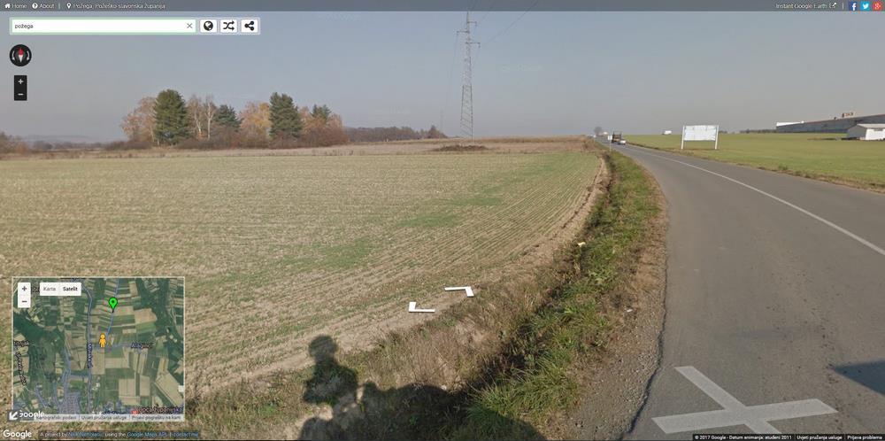
4 Geo-tagged photos Croatia: operational use since 2011 Photos taken by the controllers during RF visits or classic OTSC Hundreds of thousands of photos showing the real situation from the field at the time the photo was taken The photo speaks more than a thousand words A very useful tool for continuously collected information over the years Captured photos are useful as: - an excellent overview of the facts in the field - an audit trail, as confirmation of findings - a useful tool for checking the quality of the inspector's work

5 Geo-tagged photos Each arrow represents one georeferenced photo stored in LPIS


6 Geo-tagged photos Three options for photo geo-positioning: GNSS tool with integrated camera Simultaneously capturing the position with the GNSS tool and photos with the camera Using a camera that has an integrated GPS receiver Photos take up a lot of space on the server (Optimize photo size without dropping the quality) Sometimes there are problems with photo positions and azimuth The next step is to load photos made by farmers or other interested parties
7 Geo-tagged photos The replacement of field visit by geotagged photos coming directly from the farmers Smart mobile phones and tablets have on chipsets with GPS-receivers that determine their location with accurate position, between 4 and 15 meters. There will be problems to be solved with photo positions and azimuth of photos. It will be necessary to check, by Agency, the quality and representativeness of the photos. In some cases, however, you will need to make RFV, but in a lot less cases than now. This will reduce the agency's costs, requirements for a larger number of people involved, and increase data quality and increase the accuracy of payment approvals. It is necessary to adopt a legislative basis for the application of this solution and to develope software and methodological solutions

8 GNSS-receivers combined with GPS, GLONASS, GALILEO and EGNOS Croatia: Topcon GMS2 device Operational use since 2011 For both GPS+Glonass satellite systems Provides access to the EGNOS correction services as a standard feature. Using its internal Bluetooth connection to GSM device, GMS-2 can be configured to connect to a regional GPS reference station network (CROPOS) Profit: better and more accurate positioning and measurement in worse conditions
9 Open data Google Instantstreetview Instantstreetview covers almost all rural areas with asphalt roads In Croatia and other EU members Integration into LPIS as a layer from 2017 A useful additional source of information The photo speaks more than a thousand words Using 3D images gives a much better impression of parcel or part of the plot than just looking at 2D images from LPIS 360 degree view from the road to the parcels in the surrounding area And up to several hundred meters away from the road It should be borne in mind that the photos are not always the latest
10 Open data Google Instantstreetview

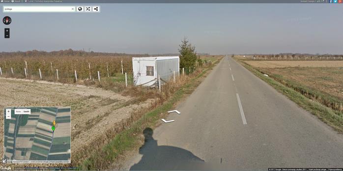
11 Open data Google Instantstreetview

12 Unmanned Aircraft Systems - Drones - very demanding to use - seek the development of special software solutions - They are looking for specially trained people - they can cover relatively small areas - Use only in special cases in limited areas - It is not for general use as the main control tool


13 Results of a small pilot project on the use of Earth Observation Products - Sentinel data in Croatia Exploratory use, no S-2 specific scientific background Basic band combinations True color False color NDVI NDWI B01 B08 B12 B01 B08 B02

14 Sentinel - hub Sentinel hub: PAYING AGENCY IN AGRICULTURE, FISHERIES AND RURAL DEVELOPMENT 12/preset=CUSTOM/layers=B04,B03,B02/maxcc=20/gain=1/gamma=1/ time= /cloudCorrection=none/atmFilter=/


15 Possibilities of use Sentinel images in conducting classical OTS controls PAYING AGENCY IN AGRICULTURE, FISHERIES AND RURAL DEVELOPMENT


16 Tools in use Sentinel Hub services integrated in OTS tools 2016 Download Images problem and solution Simple inclusion of WMS services Full control over EO products visualisation Prototype use Sentinel Playground (free web tool) Testing various combinations Exploration

")
")
17 Greening winter-crop inspection Remote control of areas with greening measure (stubble crop) Cross-check with NDVI in late autumn (November) Could be semi-automated
 PAYING AGENCY IN AGRICULTURE, FISHERIES AND RURAL DEVELOPMENT Ploughing on")
18 Possibilities of use Sentinel images in conducting controls with remote sensing (CWRS) PAYING AGENCY IN AGRICULTURE, FISHERIES AND RURAL DEVELOPMENT Ploughing on parcels


19 Cross-check of farmer s appeal Farmer claiming that water was not present during growing season; 4.3 ha of illegible area proven by use of S-2
20 Doubths and Limitations for use of Sentinel-2 in Croatia Determined possibilities of using sentinel data existence and duration of catch crops cuting on grassland ploughing on parcels if the winter soil cover is kept the existence of weeds on parcels non compliance with minimum farmers activity
21 Conclusion on use of Sentinel-2 in Croatia Pilot use in 2016 proved to add value, operational use planned for 2017 At the moment treated as a supportive layer, not yet part of official procedure Manual use, no automatics Free data, low cost of operation and benefits of additional data source make it a must-have
22 How about the future?


 if")

23 Supportive data during submission process Farmers and operators can get access to most recent imagery, which might be useful in cases of 3 years old aerial imagery Layers should not be overlaid with LPIS data to prevent point-by-point digitization/delineation (too low resolution) if presented in a pop-up, they help with interpretation but do not get in the way


24 Sentinel-powered Risk Analysis today and in the future Selection of zones Satellite imagery acquisition Selection Manual photointerpretation Rapid field-visit Ongoing ingestion of EO data Automatic identification of problems Manual postselection Manual photointerpretation Rapid field-visit Follow-up Follow-up
25 Sentinel-powered Risk Analysis Full agriculture area is checked automatically or semi-automatically country wide OTSC/CWRS process focused to identified issues to assure audit-proof evidence Long-term effects as farm holders know they are being watched Current IACS methodology does not put incentive to such processes
26 Doubths and Limitations for use of Sentinel-2 in Croatia - EK The possibility of continuously monitoring the agricultural activity Legislation should be adapted to promote ongoing monitoring The possible increase of error rate due to new technologies allowing to detect more errors. The high number of small reference parcels in MS does not allow monitoring of 100% of the areas by the Sentinel data.
27 Doubths and Limitations for use of Sentinel-2 in Croatia - EK There is still a lack of expertise, knowledge and validation of methods using sentinel data and new technologies. New algorithms need to be developed, implemented and fully tested. Sentinel image storage is a real challenge. Croatia proposes the active involvement of the EC to support the use of Sentinels data in IACS: improving data availability, providing data storage, validation of methods, software development, evaluation of the technical guidance. Best approaches must be proven by the EC before operational use.
28 Doubths and Limitations for use of Sentinel-2 in Croatia Common pilot project (EU level) are needed for proving the methodology, validation and real implementation in the IACS workflow. Croatia is willing to cooperate but also expressed the need of EC/ESA/JRC support. Common data availability is essential (common Sentinel hub) Shorter revisit time will be useful because of the presence of clouds Technical support/guidance by JRC would be appreciated More examples and more practice are necessary to implement solutions in real working environment. Croatia proposes that the EC amend the Working Document on the increase of rate on-the-spot checks in such a way that the use of those new technologies will not lead to more controls.
IACS Conference Ghent May Looking back on a season of workshops and meetings on RS
 IACS Conference Ghent 29-31 May 2017 Looking back on a season of workshops and meetings on RS Looking back at a season full of RS activities Prague Brussels Amsterdam Learning Network Panta Rhei Malta
Some elements on On-The-Spot Checks (OTSC) and area measurement
 and area measurement") Some elements on On-The-Spot Checks (OTSC) and area measurement DSCG/2014/32 FINAL Philippe LOUDJANI MARS (Monitoring Agricultural Resources) Unit DG Joint Research Centre Evidence-based scientific and
Some elements on On-The-Spot Checks (OTSC) and area measurement DSCG/2014/32 FINAL Philippe LOUDJANI MARS (Monitoring Agricultural Resources) Unit DG Joint Research Centre Evidence-based scientific and
European Space Imaging
 European Space Imaging Use cases of Very High Resolution satellite imagery in support of crop management GEO-CRADLE Regional Workshop, 7/12/2017, Tunis Arnaud Durand adurand@euspaceimaging.com COMPANY
Topcon Solutions For Land Parcel Measurement In Agriculture & Forestry. Stefan Naumann
 Topcon Solutions For Land Parcel Measurement In Agriculture & Forestry Stefan Naumann Who is Topcon? Within Positioning Various Solutions Requirements for a Solution? Solution = Method or process of solving
SUGAR_GIS. From a user perspective. Provides spatial distribution of a wide range of sugarcane production data in an easy to use and sensitive way.
 SUGAR_GIS From a user perspective What is Sugar_GIS? A web-based, decision support tool. Provides spatial distribution of a wide range of sugarcane production data in an easy to use and sensitive way.
Crop Scouting with Drones Identifying Crop Variability with UAVs
 DroneDeploy Crop Scouting with Drones Identifying Crop Variability with UAVs A Guide to Evaluating Plant Health and Detecting Crop Stress with Drone Data Table of Contents 01 Introduction Crop Scouting
European GNSS Applications in H2020
 European GNSS Applications in H2020 Countdown to H2020 12.12.2013, Brussels Carmen Aguilera European GNSS Agency Agenda European GNSS Agency EU-GNSS market potential FP7- experience and results H2020 opportunities
The use of satellite images to forecast agricultural
 The use of satellite images to forecast agricultural Luxembourg, 12.03.2014 r. Tomasz Milewski NUTS for Poland: NUTS 1 macro-regions (grup of province, voivodships) (6), NUTS 2 - regions (province,
Can Satellite Image Analysis Replace Manual Digitization?
 Can Satellite Image Analysis Replace Manual Digitization? GeoDATA London 30 th Nov 2017 LUCY KENNEDY Spottitt CEO Lucy.Kennedy@spottitt.com +44 772 594 4643 Agenda Why develop processes and services based
How Farmer Can Utilize Drone Mapping?
 Presented at the FIG Working Week 2017, May 29 - June 2, 2017 in Helsinki, Finland How Farmer Can Utilize Drone Mapping? National Land Survey of Finland Finnish Geospatial Research Institute Roope Näsi,
Organization of validation tests
 Organization of validation tests (Ortho-imagery & GNSS receivers) Berlin, November 5-7, 2013 Philippe LOUDJANI, Dominique FASBENDER, Cozmin LUCAU www.jrc.ec.europa.eu Serving society Stimulating innovation
Satellite imagery for CWRS from Irish perspective. Speaker: Aleksandra Kocon Author: Aleksandra Kocon
 Satellite imagery for CWRS from Irish perspective Speaker: Aleksandra Kocon Author: Aleksandra Kocon aleksandra@icon.ie Introduction Long acquisition windows / windows fitting with crop cycle problem Main
DG GROW - Internal Market, Industry Entrepreneurship and SMEs GROW/I1 - Space Policy and Research Unit
 1 DG GROW - Internal Market, Industry Entrepreneurship and SMEs GROW/I1 - Policy and Research Unit mats.ljungqvist@ec.europa.eu London 5 July 2016 Summary 1. in Union Research Framework Programmes 2. Programmes
DISCO-PRO AG ALL-IN-ONE DRONE SOLUTION FOR PRECISION AGRICULTURE. 80ha COVERAGE PARROT SEQUOIA INCLUDES MULTI-PURPOSE TOOL SAFE ANALYZE & DECIDE
 DISCO-PRO AG ALL-IN-ONE DRONE SOLUTION FOR PRECISION AGRICULTURE Powered by 80ha COVERAGE AT 120M * FLIGHT ALTITUDE (200AC @ 400FT) MULTI-PURPOSE TOOL PHOTO 14MPX VIDEO 1080P FULL HD PARROT SEQUOIA RGB
GSA GNSS Technology Report Main highlights IPIN 2018
 GSA GNSS Technology Report Main highlights IPIN 2018 Justyna Redelkiewicz, European GNSS Agency 25 September 2018, Nantes The European GNSS Agency (GSA) is responsible for market development and operations
Satellite Technologies for Fisheries Monitoring, Control and Surveillance (MCS)
") JRC IPSC Maritime Affairs 1 Satellite Technologies for Fisheries Monitoring, Control and Surveillance (MCS) Juan Cicuendez, Marlene Alvarez JRC Info Day Madrid, 2 June 2010 IPSC - Institute for the Protection
JRC IPSC Maritime Affairs 1 Satellite Technologies for Fisheries Monitoring, Control and Surveillance (MCS) Juan Cicuendez, Marlene Alvarez JRC Info Day Madrid, 2 June 2010 IPSC - Institute for the Protection
Geo-localization and Mosaicing System (GEMS): Enabling Precision Image Feature Location and Rapid Mosaicing General:
: Enabling Precision Image Feature Location and Rapid Mosaicing General:") Geo-localization and Mosaicing System (GEMS): Enabling Precision Image Feature Location and Rapid Mosaicing General: info@senteksystems.com www.senteksystems.com 12/6/2014 Precision Agriculture Multi-Spectral
Geo-localization and Mosaicing System (GEMS): Enabling Precision Image Feature Location and Rapid Mosaicing General: info@senteksystems.com www.senteksystems.com 12/6/2014 Precision Agriculture Multi-Spectral
Agrosky. Precision agriculture.
 Agrosky. Precision agriculture. DEUTZ-FAHR, SAME, LAMBORGHINI and HÜRLIMANN take the top option. The production cycle Farmers have always been under pressure to produce more food as the population increases,
Augmented Reality in Transportation Construction
 September 2018 Augmented Reality in Transportation Construction FHWA Contract DTFH6117C00027: LEVERAGING AUGMENTED REALITY FOR HIGHWAY CONSTRUCTION Hoda Azari, Nondestructive Evaluation Research Program
EUROPEAN GNSS APPLICATIONS IN H2020
 EUROPEAN GNSS APPLICATIONS IN H2020 Introduction to Call H2020-Galileo-2014-1 Marta Krywanis-Brzostowska Market Development European GNSS Agency www.gsa.europa.eu/r-d/h2020 Agenda R&D in the European GNSS
An Analysis of Aerial Imagery and Yield Data Collection as Management Tools in Rice Production
 RICE CULTURE An Analysis of Aerial Imagery and Yield Data Collection as Management Tools in Rice Production C.W. Jayroe, W.H. Baker, and W.H. Robertson ABSTRACT Early estimates of yield and correcting
Satellite navigation applications: opportunities from the European GNSS. Fiammetta Diani Deputy Head of Market Development European GNSS Agency
 Satellite navigation applications: opportunities from the European GNSS Fiammetta Diani Deputy Head of Market Development European GNSS Agency FP7 success story in Lithuania COSUDEC Coastal Surveying of
High resolution satellite imagery a shared and collective data source
 High resolution satellite imagery a shared and collective data source Jean-Philippe Cantou IGN France EFGS forum - Helsinki 16-18 october 2018 1 / 25 ign.fr IGN duties Produce and update the large scale
MULTISPECTRAL AGRICULTURAL ASSESSMENT. Normalized Difference Vegetation Index. Federal Robotics INSPECTION & DOCUMENTATION
 MULTISPECTRAL AGRICULTURAL ASSESSMENT Normalized Difference Vegetation Index INSPECTION & DOCUMENTATION Federal Robotics Clearwater Dr. Amherst, New York 14228 716-221-4181 Sales@FedRobot.com www.fedrobot.com
Overview of the global GNSS market and status of Galileo
 2012 GNSS.asia workshop Overview of the global GNSS market and status of Galileo 6 November, 2012 Taipei Justyna Redelkiewicz, European GNSS Agency European GNNS Agency supports European Commission in
High Resolution Multi-spectral Imagery
 High Resolution Multi-spectral Imagery Jim Baily, AirAgronomics AIRAGRONOMICS Having been involved in broadacre agriculture until 2000 I perceived a need for a high resolution remote sensing service to
EUROPEAN SPACE IMAGING: AERIAL PHOTOGRAPHY QUALITY FROM SPACE ALL TIME ALL CONTINENT
 Senior Adviser to the European Space Imaging GmbH, Munich / Germany European Delegate of DDGI (German Geo-Information Umbrella Association) Member of the Executive Committee of EUROGI (European Umbrella
SPACE: EPIC SRC workshop
 1 SPACE: EPIC SRC workshop DG GROW Internal Market, Industry Entrepreneurship and SMEs GROW/I1 - Policy and Research Unit Tanja.Zegers@ec.europa.eu Madrid, 24 October 2017 SRC & EPIC policy context H2020
Differential adoption of digital technology in the Canadian agriculture and mining sectors
 Differential adoption of digital technology in the Canadian agriculture and mining sectors Peter W.B. Phillips, Ph.D. Distinguished Professor of Public Policy Brian Wixted, Ph.D. Adjunct Professor Centre
EUROPEAN GNSS ADOPTION OPPORTUNITIES IN TRANSPORT WITH FOCUS ON RAIL
 EUROPEAN GNSS ADOPTION OPPORTUNITIES IN TRANSPORT WITH FOCUS ON RAIL Gian Gherardo Calini European GNSS Agency III Workshop GNSS Technology Advances in a Multi-Constellation Framework 22 January 2016 This
European Radio Navigation Plan. Gilles LEQUEUX, European Commission Policy Development and Strategies
 European Radio Navigation Plan Gilles LEQUEUX, European Commission Policy Development and Strategies CONTEXT - BENEFITS Space Strategy for Europe Introduction of EGNSS in EU sectoral policies Better strategic
Role, Workflow and Challenges
 1 Workshop on checks and management of agricultural land in IACS The actual use of imagery Image Processing at EFTAS Role, Workflow and Challenges Head of IT, Image Processing Unit CwRS 2 The Role 30 years
UAV Imagery and Data Management for Precision Agriculture. John Nowatzki Extension Ag Machine Systems Specialist North Dakota State University
 UAV Imagery and Data Management for Precision Agriculture John Nowatzki Extension Ag Machine Systems Specialist North Dakota State University UAS in Precision Agriculture NDSU UAS & Sensing Activities
European GNSS Evolution
 Ref. Ares(204)902599 - /06/204 European GNSS Evolution Hermann Ebner Galileo and EGNOS Programme Management DG Enterprise and Industry Content Introduction 2 2 Major Challenges for EGNSS Evolution 3 EGNSS
Validation of the QuestUAV PPK System
 Validation of the QuestUAV PPK System 3cm in xy, 400ft, no GCPs, 100Ha, 25 flights Nigel King 1, Kerstin Traut 2, Cameron Weeks 3 & Ruairi Hardman 4 1 Director QuestUAV, 2 Data Analyst QuestUAV, 3 Production
The EU Satellite Navigation programmes status Applications for the CAP
 The EU Satellite Navigation programmes status Applications for the CAP Michaël MASTIER European Commission DG ENTR GP3 GNSS Applications, Security and International aspects GPS Workshop 2010 Montpellier
Author s Name Name of the Paper Session. DYNAMIC POSITIONING CONFERENCE October 10-11, 2017 SENSORS SESSION. Sensing Autonomy.
 Author s Name Name of the Paper Session DYNAMIC POSITIONING CONFERENCE October 10-11, 2017 SENSORS SESSION Sensing Autonomy By Arne Rinnan Kongsberg Seatex AS Abstract A certain level of autonomy is already
Remote Sensing. in Agriculture. Dr. Baqer Ramadhan CRP 514 Geographic Information System. Adel M. Al-Rebh G Term Paper.
 Remote Sensing in Agriculture Term Paper to Dr. Baqer Ramadhan CRP 514 Geographic Information System By Adel M. Al-Rebh G199325390 May 2012 Table of Contents 1.0 Introduction... 4 2.0 Objective... 4 3.0
TimeSync V3 User Manual. January Introduction
 TimeSync V3 User Manual January 2017 Introduction TimeSync is an application that allows researchers and managers to characterize and quantify disturbance and landscape change by facilitating plot-level
Capture the invisible
 Capture the invisible A Capture the invisible The Sequoia multispectral sensor captures both visible and invisible images, providing calibrated data to optimally monitor the health and vigor of your crops.
Innovation in on-the-spot checks with aerial photographs; UAV and dynamic publication of orthoimages.
 Generalitat de Catalunya Innovation in on-the-spot checks with aerial photographs; UAV and dynamic publication of orthoimages. 6th GeoCAP Annual Conference: Geomatics in support of the CAP Bergamo ITALY
Earth Observation - Marine Horizonte 2020 Calls 2017
 Earth Observation - Marine Horizonte 2020 Calls 2017 Fundação para a Ciência e Tecnologia Agência de Inovação Ana Sutcliffe NCP Space Ana.sutcliffe@gppq.pt IPMA, Algés 16 September 2016 H2020 EO- Marine
European space sector, an industry view
 European space sector, an industry view ( Área reservada a imagen ) Technological and Industrial Capabilities Space, defence and European security - Kouru, 21st september 2006 MIGUEL LLOPIS/ International
SPACE. Conor Sheehan, based on presentation from DG-GROW I1 Dublin, 18th October Space
 SPACE Conor Sheehan, based on presentation from DG-GROW I1 Dublin, 18th October 2017 Space Space-related work programmes Horizon 2020 Space Work Programme 2018-2020 European Innovation Council (EIC) Pilot
Technical Notes LAND MAPPING APPLICATIONS. Leading the way with increased reliability.
 LAND MAPPING APPLICATIONS Technical Notes Leading the way with increased reliability. Industry-leading post-processing software designed to maximize the accuracy potential of your POS LV (Position and
Outline. From AGEA-JRC I (2007) to AGEA-JRC II ( ) COSMO-SkyMed constellation for Earth observation and applications
 to AGEA-JRC II ( ) COSMO-SkyMed constellation for Earth observation and applications") Outline From AGEA-JRC I (2007) to AGEA-JRC II (2008-09) COSMO-SkyMed constellation for Earth observation and applications COSMO-SkyMed GeoAccuracy assessment o Geometric o Parcels measurements performances
Outline From AGEA-JRC I (2007) to AGEA-JRC II (2008-09) COSMO-SkyMed constellation for Earth observation and applications COSMO-SkyMed GeoAccuracy assessment o Geometric o Parcels measurements performances
Copernicus Evolution: Fostering Growth in the EO Downstream Services Sector
 Copernicus Evolution: Fostering Growth in the EO Downstream Services Sector Summary: Copernicus is a European programme designed to meet the needs of the public sector for spacederived, geospatial information
23/04/2018. Global Outlook Spatial Information Industry. Graeme Kernich, CEO CRCSI
 Global Outlook 2018 Spatial Information Industry Graeme Kernich, CEO CRCSI 1 Global Outlook 2018 Spatial Information Industry 2 Global Outlook 2018: Overview 3 Source: World Economic Forum, The Global
Introduction to WG5 on CwRS imagery use and alternatives and QE5 on claimed rate inside the RP Peter Viskum Jørgensen, FERV and Birger Faurholt
 Introduction to WG5 on CwRS imagery use and alternatives and QE5 on claimed rate inside the RP Peter Viskum Jørgensen, FERV and Birger Faurholt Pedersen, University of Aarhus, DK CwRS Imagery use and alternatives
SPACE. DG GROW Internal Market, Industry Entrepreneurship and SMEs GROW/I1 - Space Policy and Research Unit
 1 SPACE DG GROW Internal Market, Industry Entrepreneurship and SMEs GROW/I1 - Policy and Research Unit Jean-Michel.Monthiller@ec.europa.eu Toulouse, 13 September 2017 European Union Programmes 3 Multiannual
Sokkia GNSS Receiver. Product Portfolio. Price GRX2 GCX2. GHX2 MESA Field Tablet SA300 S-10. Features
 Only from Sokkia GNSS Receiver Price Product Portfolio GRX2 GCX2 S-10 GHX2 MESA Field Tablet SA300 Features Product Overview Smallest and lightest GNSS integrated receiver Innovative and ergonomic shape
Crop Area Estimation with Remote Sensing
 Boogta 25-28 November 2008 1 Crop Area Estimation with Remote Sensing Some considerations and experiences for the application to general agricultural statistics Javier.gallego@jrc.it Some history: MARS
Using Freely Available. Remote Sensing to Create a More Powerful GIS
 Using Freely Available Government Data and Remote Sensing to Create a More Powerful GIS All rights reserved. ENVI, E3De, IAS, and IDL are trademarks of Exelis, Inc. All other marks are the property of
MULTIPURPOSE QUADCOPTER SOLUTION FOR AGRICULTURE
 MULTIPURPOSE QUADCOPTER SOLUTION FOR AGRICULTURE Powered by COVERS UP TO 30HA AT 70M FLIGHT ALTITUDE PER BATTERY PHOTO & VIDEO FULL HD 1080P - 14MP 3-AXIS STABILIZATION INCLUDES NDVI & ZONING MAPS SERVICE
ProMark 500 White Paper
 ProMark 500 White Paper How Magellan Optimally Uses GLONASS in the ProMark 500 GNSS Receiver How Magellan Optimally Uses GLONASS in the ProMark 500 GNSS Receiver 1. Background GLONASS brings to the GNSS
APCAS/10/21 April 2010 ASIA AND PACIFIC COMMISSION ON AGRICULTURAL STATISTICS TWENTY-THIRD SESSION. Siem Reap, Cambodia, April 2010
 APCAS/10/21 April 2010 Agenda Item 8 ASIA AND PACIFIC COMMISSION ON AGRICULTURAL STATISTICS TWENTY-THIRD SESSION Siem Reap, Cambodia, 26-30 April 2010 The Use of Remote Sensing for Area Estimation by Robert
COSMOS 2020 Infoday Bratislava Space Call 2015
 DLR.de Chart 1 COSMOS 2020 Infoday Bratislava Space Call 2015 Marc Jochemich DLR - German Aerospace Center Space Administration DLR.de Chart 2 https://ec.europa.eu/research/participants/portal/ DLR.de
Galileo. Opportunities and Challenges by Gard Ueland. November 22, 2011, Brussels. Secure World Foundation Conference. Chairman Galileo Services
 Galileo Opportunities and Challenges by Gard Ueland Chairman Galileo Services Secure World Foundation Conference The Brussels Space Policy Round Table - Galileo November 22, 2011, Brussels Galileo Launch
Assessing the Welfare of Farm Animals
 Assessing the Welfare of Farm Animals Part 1. Part 2. Review Development and Implementation of a Unified field Index (UFI) February 2013 Drewe Ferguson 1, Ian Colditz 1, Teresa Collins 2, Lindsay Matthews
Introduction to GNSS opportunities in different Market Segments. Fiammetta Diani Market Development
 Introduction to GNSS opportunities in different Market Segments Fiammetta Diani Market Development fiammetta.diani@gsa.europa.eu 3-Mar-14 European GNSS Agency 2 Congratulations! Agenda European GNSS market
PRECISION FARMING TRADE UP PROGRAM Valid until 24th June 2014
 PRECISION FARMING TRADE UP PROGRAM Valid until 24th June 2014 Trade NOW for a new 372 Receiver Part Number Description 262 Special Trade Up List Price ZTN57513363SP PLM 262 to PLM 372 GNSS Receiver, OmniSTAR,
Using Multi-spectral Imagery in MapInfo Pro Advanced
 Using Multi-spectral Imagery in MapInfo Pro Advanced MapInfo Pro Advanced Tom Probert, Global Product Manager MapInfo Pro Advanced: Intuitive interface for using multi-spectral / hyper-spectral imagery
Status of the European EGNOS and Galileo Programmes. Frank Udnaes Galileo policy and Infrastructure group EC DG-TREN. June 2008
 Status of the European EGNOS and Galileo Programmes Frank Udnaes Galileo policy and Infrastructure group EC DG-TREN EUROPEAN COMMISSION z June 2008 Galileo An infrastructure 30 satellite Constellation
GE 113 REMOTE SENSING
 GE 113 REMOTE SENSING Topic 9. Introduction to Global Positioning Systems (GPS) and Other GNSS Technologies Lecturer: Engr. Jojene R. Santillan jrsantillan@carsu.edu.ph Division of Geodetic Engineering
Digital Scouting Report
 REPORT #5799 Page 1 Digital Scouting Report Version 1.0 Flight name: SipeFarms 14Jul16 120m Location: 2731_TESTING (-105.020951791, 40.1924286792) Date: 2016-07-14 Acres: 72.49 Photos taken 91 Agribotix
Development of SPIES (Space Intelligent Eyeing System) for smart vehicle tracing and tracking
 for smart vehicle tracing and tracking") IOP Conference Series: Earth and Environmental Science PAPER OPEN ACCESS Development of SPIES (Space Intelligent Eyeing System) for smart vehicle tracing and tracking To cite this article: Suzanah Abdullah
IOP Conference Series: Earth and Environmental Science PAPER OPEN ACCESS Development of SPIES (Space Intelligent Eyeing System) for smart vehicle tracing and tracking To cite this article: Suzanah Abdullah
NASA Missions and Products: Update. Garik Gutman, LCLUC Program Manager NASA Headquarters Washington, DC
 NASA Missions and Products: Update Garik Gutman, LCLUC Program Manager NASA Headquarters Washington, DC 1 JPSS-2 (NOAA) SLI-TBD Formulation in 2015 RBI OMPS-Limb [[TSIS-2]] [[TCTE]] Land Monitoring at
New Markets Emerging from Aviation and Autonomy (M. Brancati CTO Telespazio)
") New Markets Emerging from Aviation and Autonomy (M. Brancati CTO Telespazio) 23rd Ka and Broadband Communications Conference Trieste, October 18th, 2017 2 Final Declaration G7 Transport Cagliari 22/06/2017
New Markets Emerging from Aviation and Autonomy (M. Brancati CTO Telespazio) 23rd Ka and Broadband Communications Conference Trieste, October 18th, 2017 2 Final Declaration G7 Transport Cagliari 22/06/2017
CENTRAL BANK OF MALTA
 CENTRAL BANK OF MALTA DIRECTIVE NO 10 in terms of the CENTRAL BANK OF MALTA ACT (CAP. 204) AUTHENTICATION, FITNESS CHECKING AND RECIRCULATION OF EURO BANKNOTES AND COINS Ref: CBM/10 DIRECTIVE NO 10 DIRECTIVE
Communicating Earth Observation (EO)-based landslide mapping capabilities to practitioners
-based landslide mapping capabilities to practitioners") Communicating Earth Observation (EO)-based landslide mapping capabilities to practitioners EGU 2016, Vienna, 18.04.2016 Florian Albrecht 1, Daniel Hölbling 1, Clemens Eisank 2, Elisabeth Weinke 1, Filippo
Communicating Earth Observation (EO)-based landslide mapping capabilities to practitioners EGU 2016, Vienna, 18.04.2016 Florian Albrecht 1, Daniel Hölbling 1, Clemens Eisank 2, Elisabeth Weinke 1, Filippo
Nigerian Communications Satellite Ltd. (NIGCOMSAT)
") OVERVIEW OF NIGERIAN SATELLITE AUGMENTATION SYSTEM COMMENCING WITH PILOT DEMONSTRATION TO VALIDATE NATIONAL WORK PLAN presented by Dr. Lawal Lasisi Salami, NIGERIAN COMMUNICATIONS SATELLITE LTD UNDER FEDERAL
OVERVIEW OF NIGERIAN SATELLITE AUGMENTATION SYSTEM COMMENCING WITH PILOT DEMONSTRATION TO VALIDATE NATIONAL WORK PLAN presented by Dr. Lawal Lasisi Salami, NIGERIAN COMMUNICATIONS SATELLITE LTD UNDER FEDERAL
The Galileo and EGNOS Programmes
 The Galileo and EGNOS Programmes Dominic Hayes European Commission ignss, Gold Coast, 14 July 2015 The European GNSS Programmes 2 Organisation and Contractual Frameworks European Union Member States (28)
Module 3 Introduction to GIS. Lecture 8 GIS data acquisition
 Module 3 Introduction to GIS Lecture 8 GIS data acquisition GIS workflow Data acquisition (geospatial data input) GPS Remote sensing (satellites, UAV s) LiDAR Digitized maps Attribute Data Management Data
International Programmes & GNSS Monitoring
 International Programmes & GNSS Monitoring Patrizio Vanni (patrizio.vanni@enav.it) GNSS expert ICAO PBN and PANS-OPS Provisions Implementation workshop Lisbon, 26 August 2015 Participation to PBN/GNSS
Image Acquisition Campaign 2008
 Madrid, 12-14 November, 2007 Geomatics in Support of the CAP 1 Image Acquisition Campaign 2008 Pär Johan Åstrand, Maria Erlandsson Mihaela Fotin, Cherith Aspinall JRC, CID JRC, CID Madrid, 12-14 November,
Simulation Analysis for Performance Improvements of GNSS-based Positioning in a Road Environment
 Simulation Analysis for Performance Improvements of GNSS-based Positioning in a Road Environment Nam-Hyeok Kim, Chi-Ho Park IT Convergence Division DGIST Daegu, S. Korea {nhkim, chpark}@dgist.ac.kr Soon
New Funding Opportunities to Support Safety of Navigation: EGNOS and Galileo
 New Funding Opportunities to Support Safety of Navigation: EGNOS and Galileo e-navigation Underway 31 January-2 February 2017 GSA 2016 The European GNSS Agency (GSA) today: Staff: about 145 Nationalities:
GNSS MONITORING NETWORKS
 SPACE GNSS MONITORING NETWORKS Satellite communications, earth observation, navigation and positioning and control stations indracompany.com GNSS MONITORING NETWORKS GNSS MONITORING NETWORKS Indra s solutions
UNOSAT Satellite Imagery and GIS Solutions for DRR and Emergency Management
 UNOSAT Satellite Imagery and GIS Solutions for DRR and Emergency Management Francesco Pisano Director, Research, Technology Applications & Knowledge Systems January 2013 Introduction to UNOSAT 2 About
Dimov Stojče Ilčev. CNS Systems
 Stratospheric Platform Systems (SPS) Presentation by: Dimov Stojče Ilčev Durban University of Technology (DUT) Space Science Centre (SSC) CNS Systems August 2011 SPS for Mobile CNS Applications Stratospheric
CORN BEST MANAGEMENT PRACTICES CHAPTER 22. Matching Remote Sensing to Problems
 CORN BEST MANAGEMENT PRACTICES CHAPTER 22 USDA photo by Regis Lefebure Matching Remote Sensing to Problems Jiyul Chang (Jiyul.Chang@sdstate.edu) and David Clay (David.Clay@sdstate.edu) Remote sensing can
The International Scene: How Precise Positioning Will Underpin Critical GNSS Applications
 The International Scene: How Precise Positioning Will Underpin Critical GNSS Applications School of Civil & Environmental Engineering, UNSW, Sydney, Australia Chris Rizos Member of the IGS Governing Board
GeoMax GNSS. Zenith35 Pro Series. Product Presentation V 3.0
 GeoMax GNSS Zenith35 Pro Series Product Presentation V 3.0 GeoMax Zenith35 Pro Series Table of Contents Receiver Overview Specs Options GeoMax Geo Office Datalogger Field Software Packages Promotion Material
MSB Imagery Program FAQ v1
 MSB Imagery Program FAQ v1 (F)requently (A)sked (Q)uestions 9/22/2016 This document is intended to answer commonly asked questions related to the MSB Recurring Aerial Imagery Program. Table of Contents
SPACE-BASED SOLUTIONS & ANALYTICS
 SPACE-BASED SOLUTIONS & ANALYTICS Enable development and optimisation of airspace use, and no aircraft to be lost again wherever on Earth C N S S y m p o s i u m E u r o c o n t r o l 2 & 3 O c t o b e
The (False) Color World
 Color World") There s more to the world than meets the eye In this activity, your group will explore: The Value of False Color Images Different Types of Color Images The Use of Contextual Clues for Feature Identification
There s more to the world than meets the eye In this activity, your group will explore: The Value of False Color Images Different Types of Color Images The Use of Contextual Clues for Feature Identification
Results of the field day of 8th GNSS Workshop, Dublin, 10th April 2008
 EUROPEAN COMMISSION JOINT RESEARCH CENTRE Institute for the Protection and Security of the Citizen Agriculture Unit JRC IPSC/G03/P/ASI/asi D(2008)(9481) / Report Results of the field day of 8th GNSS Workshop,
Responsible Fishing Scheme. Kara Brydson RFS Programme Manager IIFET, 13 th July 2016
 Responsible Fishing Scheme Kara Brydson RFS Programme Manager IIFET, 13 th July 2016 The UK Seafood Industry Authority A Non-Departmental Public Body Funded by a levy on first sale of marine seafood (domestic
GEOGRAPHIC INFORMATION SYSTEMS Lecture 22: Field Mapping with GPS
 GEOGRAPHIC INFORMATION SYSTEMS Lecture 22: Field Mapping with GPS GPS Receivers - there are many GPS receivers on the market today - some receivers are relatively inexpensive (recreational grade receivers)
Monitoring the EGNOS SYSTEM TEST BED at the Radio Navigation Experimentation Unit (RNEU)
") Monitoring the EGNOS SYSTEM TEST BED at the Radio Navigation Experimentation Unit (RNEU) ESTEC/ESA 2nd ESTB Workshop, Nice, 12th November 2001 What is the RNEU? Specialised facilities located at ESTEC/TOS-ET
Monitoring the EGNOS SYSTEM TEST BED at the Radio Navigation Experimentation Unit (RNEU) ESTEC/ESA 2nd ESTB Workshop, Nice, 12th November 2001 What is the RNEU? Specialised facilities located at ESTEC/TOS-ET
Top Manufacturing & Construction Technology Trends. Finding agility, security and connectivity to keep up with today s fast-paced market
 Top Manufacturing & Construction Technology Trends Finding agility, security and connectivity to keep up with today s fast-paced market Your guide to greater productivity Your business needs to balance
Global Positioning System (GPS)
") Global Positioning System (GPS) GPS enables users to easily record the location of natural and man-made features on the land. It allows users to identify where a photo or video is taken, revisit previously
Global Positioning System (GPS) GPS enables users to easily record the location of natural and man-made features on the land. It allows users to identify where a photo or video is taken, revisit previously
News on Image Acquisition for the CwRS Campaign new sensors and changes
 Control Methods Workshop: 6-8 / 4 / 2009 [CwRS KO Meeting Campaign 2009] 1 News on Image Acquisition for the CwRS Campaign 2009 - new sensors and changes Pär Johan Åstrand, Joanna Nowak, Maria Erlandsson
CHC MINING DEFORMATION MONITORING SOLUTION
 CHC MINING DEFORMATION MONITORING SOLUTION Safety is first in mining. CHC offers solutions designed to improve safety for personnel on the ground and in the cab with 24/7 precision positioning for automatic
Earth Observation Products & Services in support of the Mining Industry
 Earth Observation Products & Services in support of the Mining Industry Stephen Coulson European Space Agency Directorate of Earth Observation Programmes ESA/ESRIN 27 April 2017, Lisbon 1 ESA Earth Observation
Public Workshop on Optimising the Use of the Radio Spectrum by the Public Sector in the EU. Applications and Technologies
 Public Workshop on Optimising the Use of the Radio Spectrum by the Public Sector in the EU Applications and Technologies John Burns, Aegis Systems Ltd 1st April 2008 0 Scope of Presentation Overview of
S3P AGRI-FOOD Updates and next steps. Thematic Partnership TRACEABILITY AND BIG DATA Andalusia
 S3P AGRI-FOOD Updates and next steps Thematic Partnership TRACEABILITY AND BIG DATA Andalusia judit.anda@juntadeandalucia.es internacional.viceconsejeria.capder@juntadeandalucia.es Agro food Digital Innovation
Galileo & EGNOS Programmes Status
 Galileo & EGNOS Programmes Status Ugo Celestino, European Commission EURO-MEDITERRANEAN TRANSPORT FORUM GNSS WORKING GROUP 16 th October 2012 17 October, 2012 The European GNSS Programmes 2 Table of contents
PRELIMINARY PROGRAMME
 ICG EXPERTS MEETING: GLOBAL NAVIGATION SATELLITE SYSTEMS SERVICES 14-18 December 2015 Vienna International Centre, Vienna, Austria Organized by International Committee on Global Navigation Satellite Systems
Seasonal Progression of the Normalized Difference Vegetation Index (NDVI)
") Seasonal Progression of the Normalized Difference Vegetation Index (NDVI) For this exercise you will be using a series of six SPOT 4 images to look at the phenological cycle of a crop. The images are SPOT
Seasonal Progression of the Normalized Difference Vegetation Index (NDVI) For this exercise you will be using a series of six SPOT 4 images to look at the phenological cycle of a crop. The images are SPOT