Lab 1 Introduction to ENVI
|
|
|
- Juniper Lee
- 5 years ago
- Views:
Transcription
1 Remote sensing for agricultural applications: principles and methods ( ) Instructor: Prof. Tao Cheng Nanjing Agricultural University Lab 1 Introduction to ENVI April 1 st, 2014

2 Why ENVI? One of the best remote sensing software packages in the world Very popular in academic institutions Famous for hyperspectral analysis Developed using the programming language IDL and therefore easy to be extended with IDL

3 ENVI versions Latest version: ENVI IDL 8.3 ENVI 5.1 A significant change in the interface Changes in ENVI and IDL programming ENVI 5.1 Classic has the ENVI heritage interface. If you are a long time ENVI user since ENVI 4.0, you may want to use the Classic one. Run your old IDL scripts in ENVI Classic.
4 ENVI Start( 开始 ) -> Programs( 程序 )-> ENVI 5.1 -> Tools -> ENVI Classic + IDL After ENVI Classic is started, you should see a menu as below: Interactive Displays File management Basic Tools Classification Tools Transform Tools Filter Tools Spectral Tools Map Tools Vector Tools Topographic Tools Radar Tools
 Satellite orbit location at acquisition: path=119, row=238 File type: each band is in a separate GeoTIFF file Data format: 16-bit unsigned integer LANDSAT_SCENE_ID = \"LC81190382014075LGN00\"")
5 Test data: a Landsat Scene Collected by the OLI on Landsat-8 Time of acquisition: , 05:07:50 A Landsat-8 false color composite (4-5-3) Data_type = L1T (Landsat-8 Level 1 Terrain corrected product) Satellite orbit location at acquisition: path=119, row=238 File type: each band is in a separate GeoTIFF file Data format: 16-bit unsigned integer LANDSAT_SCENE_ID = "LC LGN00" Data download: Data files 8 TIFF files and one txt file We only use the 7 multispectral bands.
6
 0.85-0.88 0.865 30 Band 6 - SWIR 1 1.57-1.")
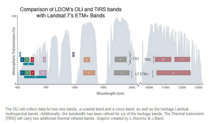
7 Landsat -8 band designations Landsat 8 Operational Land Imager (OLI) and Thermal Infrared Sensor (TIRS) Launched February 11, 2013 Bands Wavelength (µm) Band center (µm) Resolution (m) Band 1 - Coastal Band 2 - Blue Band 3 - Green Band 4 - Red Band 5 - Near Infrared (NIR) Band 6 - SWIR Band 7 - SWIR Band 8 - Panchromatic Band 9 - Cirrus Band 10 - Thermal Infrared (TIRS) 1 Band 11 - Thermal Infrared (TIRS)
8 What to do with this Landsat scene in ENVI? 1. Image loading 2. Image displaying 3. Image stacking 4. Image cropping 5. Image calibration

9 All the file and sensor types that supported by ENVI 5.1 classic. These files can be directly opened in ENVI. We are going to open Landsat-8 image files that are downloaded in GeoTIFF format. Tips: to select multiple files, hold the Ctrl key and click.
 Try making different color composites Data info: Dims 7791 x 7941: # of columns x # of rows Unsigned Int: data type = Unsigned integer (16 bit) (data range?")
10 Load your data Once your files are loaded into ENVI, you should see this window (Available Bands List). Display mode Gray Scale: individual bands RGB Color: band combinations (e.g. R-NIR-G) Try making different color composites Data info: Dims 7791 x 7941: # of columns x # of rows Unsigned Int: data type = Unsigned integer (16 bit) (data range?) BSQ: data storage method What is the file size of a 7-band Landsat-8 image?
11 Interactive displays Image window 1. Be familiar with the display group. Navigate on your image and focus on your target area. Scroll window Scroll window Zoom control
 Scrn: screen values (0~255) Projection: coordinate system Map: coordinates in m LL:")
12 2. Double click in the Image window to display cursor info. Image window How to read these values: Disp #: (col #, row #) Scrn: screen values (0~255) Projection: coordinate system Map: coordinates in m LL: coordinates in Lat/Lon Data: DN for the RGB bands Scroll window Zoom control Scroll window
?")
13 3. Right click in any window to bring up a box with commonly used functions. Image window Right click with your mouse: How to locate the pixel for Ruigao ( ºN, ºE)? Scroll window Scroll window Zoom control


14 Save data as ENVI standard format Step 1 Step 2 Load Landsat-8 bands 1~7 and stack them up to generate a multispectral image file. Step 3 Step 4


15 Edit band names Step 2 Step 4 Step 1 Assign meaningful band names. Find this file in your working directory. Check if the file size matches the number you calculated in slide 8. Step 3


16 Image cropping: create a subset image Step 1: draw a rectangle ROI in the Scroll window to include your study area (hold left key and drag, right click to select).

17 The subset image is in display.
 M L = the band-specific multiplicative")
 DN = Landsat-8 level-1 product pixel values Step 1")
18 Conversion of DN to TOA (Top of Atmosphere) radiance L = M L DN + A L L λ = TOA spectral radiance (W/m2*srad*um) M L = the band-specific multiplicative factor (RADIANCE_MULT_BAND_x) A L = the band-specific multiplicative factor (RADIANCE_ADD_BAND_x) DN = Landsat-8 level-1 product pixel values Step 1 Step 2


19 Input band-specific gain and offset values Gain = RADIANCE_MULT_BAND_x (in the *_MTL.txt file) Offset = RADIANCE_ADD_BAND_x


20 Compare DN data to radiance data Radiance data Unit: W/m2*srad*um DN data Unit: dimensionless
21 Resources ENVI help documentation eaks.aspx - Imagery Speaks Blog (a good blog site) - ENVI/IDL webinars - Exelis VIS, the developer of IDL. int.aspx - IDL data point (a good Blog site) LearnIDL.com Dr. Ken Bowman s web site - Coyote s guide to IDL programming (IDL tips, training, consulting) - Practical IDL programming (IDL book) - resources for IDL developers
22 Class project Think about what to do in your project. Make a tem of two students for each project. Start developing ideas and collecting materials (making notes is necessary) for your project. Allocate reasonable workload.
Basic Hyperspectral Analysis Tutorial
 Basic Hyperspectral Analysis Tutorial This tutorial introduces you to visualization and interactive analysis tools for working with hyperspectral data. In this tutorial, you will: Analyze spectral profiles
Remote Sensing Instruction Laboratory
 Laboratory Session 217513 Geographic Information System and Remote Sensing - 1 - Remote Sensing Instruction Laboratory Assist.Prof.Dr. Weerakaset Suanpaga Department of Civil Engineering, Faculty of Engineering
Lesson 3: Working with Landsat Data
 Lesson 3: Working with Landsat Data Lesson Description The Landsat Program is the longest-running and most extensive collection of satellite imagery for Earth. These datasets are global in scale, continuously
Files Used in This Tutorial. Background. Calibrating Images Tutorial
 In this tutorial, you will calibrate a QuickBird Level-1 image to spectral radiance and reflectance while learning about the various metadata fields that ENVI uses to perform calibration. This tutorial
29 th Annual Louisiana RS/GIS Workshop April 23, 2013 Cajundome Convention Center Lafayette, Louisiana
 Landsat Data Continuity Mission 29 th Annual Louisiana RS/GIS Workshop April 23, 2013 Cajundome Convention Center Lafayette, Louisiana http://landsat.usgs.gov/index.php# Landsat 5 Sets Guinness World Record
Enhancement of Multispectral Images and Vegetation Indices
 Enhancement of Multispectral Images and Vegetation Indices ERDAS Imagine 2016 Description: We will use ERDAS Imagine with multispectral images to learn how an image can be enhanced for better interpretation.
NON-PHOTOGRAPHIC SYSTEMS: Multispectral Scanners Medium and coarse resolution sensor comparisons: Landsat, SPOT, AVHRR and MODIS
 NON-PHOTOGRAPHIC SYSTEMS: Multispectral Scanners Medium and coarse resolution sensor comparisons: Landsat, SPOT, AVHRR and MODIS CLASSIFICATION OF NONPHOTOGRAPHIC REMOTE SENSORS PASSIVE ACTIVE DIGITAL
Land Cover Change Analysis An Introduction to Land Cover Change Analysis using the Multispectral Image Data Analysis System (MultiSpec )
") Land Cover Change Analysis An Introduction to Land Cover Change Analysis using the Multispectral Image Data Analysis System (MultiSpec ) Level: Grades 9 to 12 Macintosh version Earth Observation Day Tutorial
Land Cover Change Analysis An Introduction to Land Cover Change Analysis using the Multispectral Image Data Analysis System (MultiSpec ) Level: Grades 9 to 12 Macintosh version Earth Observation Day Tutorial
Files Used in this Tutorial
 Burn Indices Tutorial This tutorial shows how to create various burn index images from Landsat 8 imagery, using the May 2014 San Diego County wildfires as a case study. You will learn how to perform the
Landsat 8 Pansharpen and Mosaic Geomatica 2015 Tutorial
 Landsat 8 Pansharpen and Mosaic Geomatica 2015 Tutorial On February 11, 2013, Landsat 8 was launched adding to the constellation of Earth imaging satellites. It is the seventh satellite to reach orbit
BV NNET User manual. V0.2 (Draft) Rémi Lecerf, Marie Weiss
 Rémi Lecerf, Marie Weiss") BV NNET User manual V0.2 (Draft) Rémi Lecerf, Marie Weiss 1. Introduction... 2 2. Installation... 2 3. Prerequisites... 2 3.1. Image file format... 2 3.2. Retrieving atmospheric data... 3 3.2.1. Using
BV NNET User manual V0.2 (Draft) Rémi Lecerf, Marie Weiss 1. Introduction... 2 2. Installation... 2 3. Prerequisites... 2 3.1. Image file format... 2 3.2. Retrieving atmospheric data... 3 3.2.1. Using
Remote Sensing in Daily Life. What Is Remote Sensing?
 Remote Sensing in Daily Life What Is Remote Sensing? First time term Remote Sensing was used by Ms Evelyn L Pruitt, a geographer of US in mid 1950s. Minimal definition (not very useful): remote sensing
Land Cover Change Analysis An Introduction to Land Cover Change Analysis using the Multispectral Image Data Analysis System (MultiSpec )
") Land Cover Change Analysis An Introduction to Land Cover Change Analysis using the Multispectral Image Data Analysis System (MultiSpec ) Level: Grades 9 to 12 Windows version With Teacher Notes Earth Observation
Land Cover Change Analysis An Introduction to Land Cover Change Analysis using the Multispectral Image Data Analysis System (MultiSpec ) Level: Grades 9 to 12 Windows version With Teacher Notes Earth Observation
Downloading and formatting remote sensing imagery using GLOVIS
 Downloading and formatting remote sensing imagery using GLOVIS Students will become familiarized with the characteristics of LandSat, Aerial Photos, and ASTER medium resolution imagery through the USGS
How to Access Imagery and Carry Out Remote Sensing Analysis Using Landsat Data in a Browser
 How to Access Imagery and Carry Out Remote Sensing Analysis Using Landsat Data in a Browser Including Introduction to Remote Sensing Concepts Based on: igett Remote Sensing Concept Modules and GeoTech
Module 11 Digital image processing
 Introduction Geo-Information Science Practical Manual Module 11 Digital image processing 11. INTRODUCTION 11-1 START THE PROGRAM ERDAS IMAGINE 11-2 PART 1: DISPLAYING AN IMAGE DATA FILE 11-3 Display of
University of Texas at San Antonio EES 5053 Term Project CORRELATION BETWEEN NDVI AND SURFACE TEMPERATURES USING LANDSAT ETM + IMAGERY NEWFEL MAZARI
 University of Texas at San Antonio EES 5053 Term Project CORRELATION BETWEEN NDVI AND SURFACE TEMPERATURES USING LANDSAT ETM + IMAGERY NEWFEL MAZARI Introduction and Objectives The present study is a correlation
Lecture 7 Earth observation missions
 Remote sensing for agricultural applications: principles and methods (2013-2014) Instructor: Prof. Tao Cheng (tcheng@njau.edu.cn). Nanjing Agricultural University Lecture 7 Earth observation missions May
Planet Labs Inc 2017 Page 2
 SKYSAT IMAGERY PRODUCT SPECIFICATION: ORTHO SCENE LAST UPDATED JUNE 2017 SALES@PLANET.COM PLANET.COM Disclaimer This document is designed as a general guideline for customers interested in acquiring Planet
IMAGE ANALYSIS TOOLBOX AND ENHANCED SATELLITE IMAGERY INTEGRATED INTO THE MAPPLACE By Ward E. Kilby 1, Karl Kliparchuk 2 and Andrew McIntosh 2
 IMAGE ANALYSIS TOOLBOX AND ENHANCED SATELLITE IMAGERY INTEGRATED INTO THE MAPPLACE By Ward E. Kilby 1, Karl Kliparchuk 2 and Andrew McIntosh 2 KEYWORDS: MapPlace, Landsat, ASTER, Image Analysis, Structural
RGB colours: Display onscreen = RGB
 RGB colours: http://www.colorspire.com/rgb-color-wheel/ Display onscreen = RGB DIGITAL DATA and DISPLAY Myth: Most satellite images are not photos Photographs are also 'images', but digital images are
Due Date: September 22
 Geography 309 Lab 1 Page 1 LAB 1: INTRODUCTION TO REMOTE SENSING Due Date: September 22 Objectives To familiarize yourself with: o remote sensing resources on the Internet o some remote sensing sensors
Using the Chip Database
 Using the Chip Database TUTORIAL A chip database is a collection of image chips or subsetted images where each image has a GCP associated with it. A chip database can be useful when orthorectifying different
MAPS AND SATELLITE IMAGES TOOLS FOR AN EFFECTIVE MANAGEMENT OF THE HISTORIC CENTER OF SIGHISOARA, AN UNESCO WORLD HERITAGE SITE
 Journal of Young Scientist, Volume VI, 2018 ISSN 2344-1283; ISSN CD-ROM 2344-1291; ISSN Online 2344-1305; ISSN-L 2344 1283 MAPS AND SATELLITE IMAGES TOOLS FOR AN EFFECTIVE MANAGEMENT OF THE HISTORIC CENTER
Land Remote Sensing Lab 4: Classication and Change Detection Assigned: October 15, 2017 Due: October 27, Classication
 Name: Land Remote Sensing Lab 4: Classication and Change Detection Assigned: October 15, 2017 Due: October 27, 2017 In this lab, you will generate several gures. Please sensibly name these images, save
Remote Sensing 4113 Lab 10: Lunar Classification April 11, 2018
 Remote Sensing 4113 Lab 10: Lunar Classification April 11, 2018 Part I Introduction In this lab we ll explore the use of sophisticated band math to estimate composition, and we ll also explore the use
QGIS LAB SERIES GST 101: Introduction to Geospatial Technology Lab 6: Understanding Remote Sensing and Analysis
 QGIS LAB SERIES GST 101: Introduction to Geospatial Technology Lab 6: Understanding Remote Sensing and Analysis Objective Explore and Understand How to Display and Analyze Remotely Sensed Imagery Document
Remote Sensing And Gis Application in Image Classification And Identification Analysis.
 Quest Journals Journal of Research in Environmental and Earth Science Volume 3~ Issue 5 (2017) pp: 55-66 ISSN(Online) : 2348-2532 www.questjournals.org Research Paper Remote Sensing And Gis Application
Using Freely Available. Remote Sensing to Create a More Powerful GIS
 Using Freely Available Government Data and Remote Sensing to Create a More Powerful GIS All rights reserved. ENVI, E3De, IAS, and IDL are trademarks of Exelis, Inc. All other marks are the property of
An Introduction to Remote Sensing & GIS. Introduction
 An Introduction to Remote Sensing & GIS Introduction Remote sensing is the measurement of object properties on Earth s surface using data acquired from aircraft and satellites. It attempts to measure something
USGS Welcome. 38 th CEOS Working Group on Calibration and Validation Plenary (WGCV-38)
") Landsat 5 USGS Welcome Prepared for 38 th CEOS Working Group on Calibration and Validation Plenary (WGCV-38) Presenter Tom Cecere International Liaison USGS Land Remote Sensing Program Elephant Butte Reservoir
Landsat 5 USGS Welcome Prepared for 38 th CEOS Working Group on Calibration and Validation Plenary (WGCV-38) Presenter Tom Cecere International Liaison USGS Land Remote Sensing Program Elephant Butte Reservoir
IKONOS High Resolution Multispectral Scanner Sensor Characteristics
 High Spatial Resolution and Hyperspectral Scanners IKONOS High Resolution Multispectral Scanner Sensor Characteristics Launch Date View Angle Orbit 24 September 1999 Vandenberg Air Force Base, California,
FUNDAMENTALS OF DIGITAL IMAGES
 FUNDAMENTALS OF DIGITAL IMAGES Lecture Image Data Structures Common Data Structures to Store Multiband Data BIL band interleaved by line BSQ band sequential BIP band interleaved by pixel Example Band Band
Lab 3: Image Enhancements I 65 pts Due > Canvas by 10pm
 Geo 448/548 Spring 2016 Lab 3: Image Enhancements I 65 pts Due > Canvas by 3/11 @ 10pm For this lab, you will learn different ways to calculate spectral vegetation indices (SVIs). These are one category
TimeSync V3 User Manual. January Introduction
 TimeSync V3 User Manual January 2017 Introduction TimeSync is an application that allows researchers and managers to characterize and quantify disturbance and landscape change by facilitating plot-level
LAND SURFACE TEMPERATURE MONITORING THROUGH GIS TECHNOLOGY USING SATELLITE LANDSAT IMAGES
 Abstract LAND SURFACE TEMPERATURE MONITORING THROUGH GIS TECHNOLOGY USING SATELLITE LANDSAT IMAGES Aurelian Stelian HILA, Zoltán FERENCZ, Sorin Mihai CIMPEANU University of Agronomic Sciences and Veterinary
Satellite Remote Sensing: Earth System Observations
 Satellite Remote Sensing: Earth System Observations Land surface Water Atmosphere Climate Ecosystems 1 EOS (Earth Observing System) Develop an understanding of the total Earth system, and the effects of
Viewing Landsat TM images with Adobe Photoshop
 Viewing Landsat TM images with Adobe Photoshop Reformatting images into GeoTIFF format Of the several formats in which Landsat TM data are available, only a few formats (primarily TIFF or GeoTIFF) can
Assessment of Spatiotemporal Changes in Vegetation Cover using NDVI in The Dangs District, Gujarat
 Assessment of Spatiotemporal Changes in Vegetation Cover using NDVI in The Dangs District, Gujarat Using SAGA GIS and Quantum GIS Tutorial ID: IGET_CT_003 This tutorial has been developed by BVIEER as
Laboratory Exercise 1
 Page 1 Laboratory Exercise 1 GEOG*2420 The Earth From Space University of Guelph, Department of Geography Prof. John Lindsay Fall 2013 Total of 32 marks Learning objectives The intention of this lab exercise
ATCOR Workflow for IMAGINE 2016
 ATCOR Workflow for IMAGINE 2016 Version 1.0 Step-by-Step Guide January 2017 ATCOR Workflow for IMAGINE Page 2/24 The ATCOR trademark is owned by DLR German Aerospace Center D-82234 Wessling, Germany URL:
Lecture 6: Multispectral Earth Resource Satellites. The University at Albany Fall 2018 Geography and Planning
 Lecture 6: Multispectral Earth Resource Satellites The University at Albany Fall 2018 Geography and Planning Outline SPOT program and other moderate resolution systems High resolution satellite systems
Lab 1: Introduction to MODIS data and the Hydra visualization tool 21 September 2011
 WMO RA Regional Training Course on Satellite Applications for Meteorology Cieko, Bogor Indonesia 19-27 September 2011 Kathleen Strabala University of Wisconsin-Madison, USA kathy.strabala@ssec.wisc.edu
Sommersemester Prof. Dr. Christoph Kleinn Institut für Waldinventur und Waldwachstum Arbeitsbereich Fernerkundung und Waldinventur.
 Basics of Remote Sensing Some literature references Franklin, SE 2001 Remote Sensing for Sustainable Forest Management Lewis Publishers 407p Lillesand, Kiefer 2000 Remote Sensing and Image Interpretation
GEOSS Americas/Caribbean Remote Sensing Workshop November Lab 2 Investigating Cloud Phase, NDVI, Ocean Color and Sea Surface Temperatures
 GEOSS Americas/Caribbean Remote Sensing Workshop 26-30 November 2007 Lab 2 Investigating Cloud Phase, NDVI, Ocean Color and Sea Surface Temperatures Kathleen Strabala kathy.strabala@ssec.wisc.edu Table:
Landsat 8. Snabba leveranser av bilder till användarna. Lars-Åke Edgardh. tisdag 9 april 13
 Landsat 8 Snabba leveranser av bilder till användarna Lars-Åke Edgardh Keystone A single system for: Many sensors Many types of clients Hides the complexity of sensors. Specialised on: Services High volume
PLANET IMAGERY PRODUCT SPECIFICATIONS PLANET.COM
 PLANET IMAGERY PRODUCT SPECIFICATIONS SUPPORT@PLANET.COM PLANET.COM LAST UPDATED JANUARY 2018 TABLE OF CONTENTS LIST OF FIGURES 3 LIST OF TABLES 4 GLOSSARY 5 1. OVERVIEW OF DOCUMENT 7 1.1 Company Overview
Impact toolbox. ZIP/DN to TOA reflectance. Principles and tutorial
 Impact toolbox ZIP/DN to TOA reflectance Principles and tutorial ZIP/DN to TOA reflectance principles RapidEye, Landsat and Sentinel 2 are distributed by their owner in a specific format. The file itself
Menzel / Antonelli Lab 1 Using HYDRA to Inspect Multispectral Remote Sensing Data
 Menzel / Antonelli Lab 1 Using HYDRA to Inspect Multispectral Remote Sensing Data Table: MODIS Channel Number, Wavelength (µm), and Primary Application Reflective Bands Emissive Bands 1,2 0.645, 0.865
Creating a Colour Composite from MERIS L1 Data
 LearnEO! Bilko Tutorial T2.4 www.learn-eo.org/tutorial/ Creating a Colour Composite from MERIS L1 Data Required resources MER_FR 1PNEPA20080812_095210_~.N1 - Envisat MERIS Full Resolution Level 1 data
Introduction of Satellite Remote Sensing
 Introduction of Satellite Remote Sensing Spatial Resolution (Pixel size) Spectral Resolution (Bands) Resolutions of Remote Sensing 1. Spatial (what area and how detailed) 2. Spectral (what colors bands)
EE/GP140-The Earth From Space- Winter 2008 Handout #16 Lab Exercise #3
 EE/GP140-The Earth From Space- Winter 2008 Handout #16 Lab Exercise #3 Topic 1: Color Combination. We will see how all colors can be produced by combining red, green, and blue in different proportions.
Course overview; Remote sensing introduction; Basics of image processing & Color theory
 GEOL 1460 /2461 Ramsey Introduction to Remote Sensing Fall, 2018 Course overview; Remote sensing introduction; Basics of image processing & Color theory Week #1: 29 August 2018 I. Syllabus Review we will
Grant Boxer Consultant Geologist March 10th 2014 (Updated Nov 2014)
") Grant Boxer Consultant Geologist March 10th 2014 (Updated Nov 2014) Work flow for Landsat 8 Landgate Data Selecting and processing basic data Importing into MapInfo Applications SLIP Portal WMS access
Grant Boxer Consultant Geologist March 10th 2014 (Updated Nov 2014) Work flow for Landsat 8 Landgate Data Selecting and processing basic data Importing into MapInfo Applications SLIP Portal WMS access
REMOTE SENSING INTERPRETATION
 REMOTE SENSING INTERPRETATION Jan Clevers Centre for Geo-Information - WU Remote Sensing --> RS Sensor at a distance EARTH OBSERVATION EM energy Earth RS is a tool; one of the sources of information! 1
GIS and Remote Sensing
 GE110 Fall 2008 Week 4 October 18, 2010 GIS and Remote Sensing Lab 2 LANDSAT 7 and ASTER In this lab, you will: 1. Process the LANDSAT 7 ETM+ image to emphasize the useful information a. Transformations
The studies began when the Tiros satellites (1960) provided man s first synoptic view of the Earth s weather systems.
 provided man s first synoptic view of the Earth s weather systems.") Remote sensing of the Earth from orbital altitudes was recognized in the mid-1960 s as a potential technique for obtaining information important for the effective use and conservation of natural resources.
Remote sensing of the Earth from orbital altitudes was recognized in the mid-1960 s as a potential technique for obtaining information important for the effective use and conservation of natural resources.
GROßFLÄCHIGE UND HOCHFREQUENTE BEOBACHTUNG VON AGRARFLÄCHEN DURCH OPTISCHE SATELLITEN (RAPIDEYE, LANDSAT 8, SENTINEL-2)
") GROßFLÄCHIGE UND HOCHFREQUENTE BEOBACHTUNG VON AGRARFLÄCHEN DURCH OPTISCHE SATELLITEN (RAPIDEYE, LANDSAT 8, SENTINEL-2) Karsten Frotscher Produktmanager Landwirtschaft Slide 1 A Couple Of Words About The
GROßFLÄCHIGE UND HOCHFREQUENTE BEOBACHTUNG VON AGRARFLÄCHEN DURCH OPTISCHE SATELLITEN (RAPIDEYE, LANDSAT 8, SENTINEL-2) Karsten Frotscher Produktmanager Landwirtschaft Slide 1 A Couple Of Words About The
Precision Remote Sensing and Image Processing for Precision Agriculture (PA)
") Precision Remote Sensing and Image Processing for Precision Agriculture (PA) Dr. Jack F. Paris Presented to Colorado State University, Fort Collins, CO October 20, 2005 Speaker s Current Activities: Consultant
Precision Remote Sensing and Image Processing for Precision Agriculture (PA) Dr. Jack F. Paris Presented to Colorado State University, Fort Collins, CO October 20, 2005 Speaker s Current Activities: Consultant
Multilook scene classification with spectral imagery
 Multilook scene classification with spectral imagery Richard C. Olsen a*, Brandt Tso b a Physics Department, Naval Postgraduate School, Monterey, CA, 93943, USA b Department of Resource Management, National
The (False) Color World
 Color World") There s more to the world than meets the eye In this activity, your group will explore: The Value of False Color Images Different Types of Color Images The Use of Contextual Clues for Feature Identification
There s more to the world than meets the eye In this activity, your group will explore: The Value of False Color Images Different Types of Color Images The Use of Contextual Clues for Feature Identification
White Paper. Medium Resolution Images and Clutter From Landsat 7 Sources. Pierre Missud
 White Paper Medium Resolution Images and Clutter From Landsat 7 Sources Pierre Missud Medium Resolution Images and Clutter From Landsat7 Sources Page 2 of 5 Introduction Space technologies have long been
Unsupervised Classification
 Unsupervised Classification Using SAGA Tutorial ID: IGET_RS_007 This tutorial has been developed by BVIEER as part of the IGET web portal intended to provide easy access to geospatial education. This tutorial
Module 3 Introduction to GIS. Lecture 8 GIS data acquisition
 Module 3 Introduction to GIS Lecture 8 GIS data acquisition GIS workflow Data acquisition (geospatial data input) GPS Remote sensing (satellites, UAV s) LiDAR Digitized maps Attribute Data Management Data
Present and future of marine production in Boka Kotorska
 Present and future of marine production in Boka Kotorska First results from satellite remote sensing for the breeding areas of filter feeders in the Bay of Kotor INTRODUCTION Environmental monitoring is
Lab 6: Multispectral Image Processing Using Band Ratios
 Lab 6: Multispectral Image Processing Using Band Ratios due Dec. 11, 2017 Goals: 1. To learn about the spectral characteristics of vegetation and geologic materials. 2. To experiment with vegetation indices
AmericaView EOD 2016 page 1 of 16
 Remote Sensing Flood Analysis Lesson Using MultiSpec Online By Larry Biehl Systems Manager, Purdue Terrestrial Observatory (biehl@purdue.edu) v Objective The objective of these exercises is to analyze
On the use of water color missions for lakes in 2021
 Lakes and Climate: The Role of Remote Sensing June 01-02, 2017 On the use of water color missions for lakes in 2021 Cédric G. Fichot Department of Earth and Environment 1 Overview 1. Past and still-ongoing
DESIS Applications & Processing Extracted from Teledyne & DLR Presentations to JACIE April 14, Ray Perkins, Teledyne Brown Engineering
 DESIS Applications & Processing Extracted from Teledyne & DLR Presentations to JACIE April 14, 2016 Ray Perkins, Teledyne Brown Engineering 1 Presentation Agenda Imaging Spectroscopy Applications of DESIS
CHAPTER 7: Multispectral Remote Sensing
 CHAPTER 7: Multispectral Remote Sensing REFERENCE: Remote Sensing of the Environment John R. Jensen (2007) Second Edition Pearson Prentice Hall Overview of How Digital Remotely Sensed Data are Transformed
Calibration of a Multi-Spectral CubeSat with LandSat Filters
 Calibration of a Multi-Spectral CubeSat with LandSat Filters Sloane Wiktorowicz, Ray Russell, Dee Pack, Eric Herman, George Rossano, Christopher Coffman, Brian Hardy, & Bonnie Hattersley (The Aerospace
Landsat 8, Level 1 Product Performance Cyclic Report July 2016
 Landsat 8, Level 1 Product Performance Cyclic Report July 2016 Author(s) : Sébastien Saunier (IDEAS+, Telespazio VEGA) Amy Northrop (IDEAS+, Telespazio VEGA) IDEAS+-VEG-OQC-REP-2647 Issue July 2016 1 September
-f/d-b '') o, q&r{laniels, Advisor. 20rt. lmage Processing of Petrographic and SEM lmages. By James Gonsiewski. The Ohio State University
 o, q&r{laniels, Advisor. 20rt. lmage Processing of Petrographic and SEM lmages. By James Gonsiewski. The Ohio State University") lmage Processing of Petrographic and SEM lmages Senior Thesis Submitted in partial fulfillment of the requirements for the Bachelor of Science Degree At The Ohio State Universitv By By James Gonsiewski
lmage Processing of Petrographic and SEM lmages Senior Thesis Submitted in partial fulfillment of the requirements for the Bachelor of Science Degree At The Ohio State Universitv By By James Gonsiewski
Benchtop System Quick Start
 Benchtop System Quick Start Release 5.2 Resonon Inc. Dec 11, 2018 CONTENTS 1 System Overview 1 2 Basic Data Acquisition 3 2.1 Data Modes................................................ 3 2.2 Start The
REMOTE SENSING. Topic 10 Fundamentals of Digital Multispectral Remote Sensing MULTISPECTRAL SCANNERS MULTISPECTRAL SCANNERS
 REMOTE SENSING Topic 10 Fundamentals of Digital Multispectral Remote Sensing Chapter 5: Lillesand and Keifer Chapter 6: Avery and Berlin MULTISPECTRAL SCANNERS Record EMR in a number of discrete portions
Part 1 Using GIS for Tsunami Disaster Assessment
 Tsunami_Hood_SG_June_2009 Learning Unit Student Guide Outline Name of Creator: Scott Hood Institution: Kennebec Valley Community College Email contact for more information: shood@kvcc.me.edu Title: Tsunami
2. DATA AND METHOD Data and Research Sites
 International Journal of Remote Sensing and Earth Sciences Vol.13 No.1 Juni 2016 : hal 51 60 DEVELOPMENT OF ANNUAL LANDSAT-8 COMPOSITE OVER CENTRAL KALIMANTAN, INDONESIA USING AUTOMATIC ALGORITHM TO MINIMIZES
INTERNATIONAL JOURNAL OF ENVIRONMENTAL SCIENCES Volume 6, No 5, Copyright by the authors - Licensee IPA- Under Creative Commons license 3.
 INTERNATIONAL JOURNAL OF ENVIRONMENTAL SCIENCES Volume 6, No 5, 2016 Copyright by the authors - Licensee IPA- Under Creative Commons license 3.0 Research article ISSN 0976 4402 Normalised difference water
GEOG432: Remote sensing Lab 3 Unsupervised classification
 GEOG432: Remote sensing Lab 3 Unsupervised classification Goal: This lab involves identifying land cover types by using agorithms to identify pixels with similar Digital Numbers (DN) and spectral signatures
GIS Data Collection. Remote Sensing
 GIS Data Collection Remote Sensing Data Collection Remote sensing Introduction Concepts Spectral signatures Resolutions: spectral, spatial, temporal Digital image processing (classification) Other systems
v References Nexus RS Workshop (English Version) August 2018 page 1 of 44
 August 2018 page 1 of 44") v References NEXUS Remote Sensing Workshop August 6, 2018 Intro to Remote Sensing using MultiSpec By Larry Biehl Systems Manager, Purdue Terrestrial Observatory (biehl@purdue.edu) MultiSpec Introduction
v References NEXUS Remote Sensing Workshop August 6, 2018 Intro to Remote Sensing using MultiSpec By Larry Biehl Systems Manager, Purdue Terrestrial Observatory (biehl@purdue.edu) MultiSpec Introduction
366 Glossary. Popular method for scale drawings in a computer similar to GIS but without the necessity for spatial referencing CEP
 366 Glossary GISci Glossary ASCII ASTER American Standard Code for Information Interchange Advanced Spaceborne Thermal Emission and Reflection Radiometer Computer Aided Design Circular Error Probability
remote sensing? What are the remote sensing principles behind these Definition
 Introduction to remote sensing: Content (1/2) Definition: photogrammetry and remote sensing (PRS) Radiation sources: solar radiation (passive optical RS) earth emission (passive microwave or thermal infrared
Radiometric Use of WorldView-3 Imagery. Technical Note. 1 WorldView-3 Instrument. 1.1 WorldView-3 Relative Radiance Response
 Radiometric Use of WorldView-3 Imagery Technical Note Date: 2016-02-22 Prepared by: Michele Kuester This technical note discusses the radiometric use of WorldView-3 imagery. The first two sections briefly
Atmospheric interactions; Aerial Photography; Imaging systems; Intro to Spectroscopy Week #3: September 12, 2018
 GEOL 1460/2461 Ramsey Introduction/Advanced Remote Sensing Fall, 2018 Atmospheric interactions; Aerial Photography; Imaging systems; Intro to Spectroscopy Week #3: September 12, 2018 I. Quick Review from
Application of GIS to Fast Track Planning and Monitoring of Development Agenda
 Application of GIS to Fast Track Planning and Monitoring of Development Agenda Radiometric, Atmospheric & Geometric Preprocessing of Optical Remote Sensing 13 17 June 2018 Outline 1. Why pre-process remotely
Important Missions. weather forecasting and monitoring communication navigation military earth resource observation LANDSAT SEASAT SPOT IRS
 Fundamentals of Remote Sensing Pranjit Kr. Sarma, Ph.D. Assistant Professor Department of Geography Mangaldai College Email: prangis@gmail.com Ph. No +91 94357 04398 Remote Sensing Remote sensing is defined
Landsat 8, Level 1 Product Performance Cyclic Report February 2017
 Landsat 8, Level 1 Product Performance Cyclic Report February 2017 Author(s) : Sébastien Saunier (IDEAS+, Telespazio VEGA) Amy Northrop (IDEAS+, Telespazio VEGA) IDEAS+-VEG-OQC-REP-2647 Issue February
Ground Truth for Calibrating Optical Imagery to Reflectance
 Visual Information Solutions Ground Truth for Calibrating Optical Imagery to Reflectance The by: Thomas Harris Whitepaper Introduction: Atmospheric Effects on Optical Imagery Remote sensing of the Earth
Landsat 8, Level 1 Product Performance Cyclic Report November 2016
 Landsat 8, Level 1 Product Performance Cyclic Report November 2016 Author(s) : Sébastien Saunier (IDEAS+, Telespazio VEGA) Amy Northrop (IDEAS+, Telespazio VEGA) IDEAS+-VEG-OQC-REP-2647 Issue November
Supervised Land Cover Classification An introduction to digital image classification using the Multispectral Image Data Analysis System (MultiSpec )
") Supervised Land Cover Classification An introduction to digital image classification using the Multispectral Image Data Analysis System (MultiSpec ) Level: Grades 9 to 12 Windows version With Teacher Notes
Supervised Land Cover Classification An introduction to digital image classification using the Multispectral Image Data Analysis System (MultiSpec ) Level: Grades 9 to 12 Windows version With Teacher Notes
Global hot spot monitoring with Landsat 8 and Sentinel-2. Soushi Kato Atsushi Oda Ryosuke Nakamura (AIST)
") Global hot spot monitoring with Landsat 8 and Sentinel-2 Soushi Kato Atsushi Oda Ryosuke Nakamura (AIST) Motivation for Detecting Hot Spots Hotspot detection using satellite data To monitor wildfire and
Global hot spot monitoring with Landsat 8 and Sentinel-2 Soushi Kato Atsushi Oda Ryosuke Nakamura (AIST) Motivation for Detecting Hot Spots Hotspot detection using satellite data To monitor wildfire and
CHARACTERISTICS OF REMOTELY SENSED IMAGERY. Radiometric Resolution
 CHARACTERISTICS OF REMOTELY SENSED IMAGERY Radiometric Resolution There are a number of ways in which images can differ. One set of important differences relate to the various resolutions that images express.
Int n r t o r d o u d c u ti t on o n to t o Remote Sensing
 Introduction to Remote Sensing Definition of Remote Sensing Remote sensing refers to the activities of recording/observing/perceiving(sensing)objects or events at far away (remote) places. In remote sensing,
Textbook, Chapter 15 Textbook, Chapter 10 (only 10.6)
") AGOG 484/584/ APLN 551 Fall 2018 Concept definition Applications Instruments and platforms Techniques to process hyperspectral data A problem of mixed pixels and spectral unmixing Reading Textbook, Chapter
AGOG 484/584/ APLN 551 Fall 2018 Concept definition Applications Instruments and platforms Techniques to process hyperspectral data A problem of mixed pixels and spectral unmixing Reading Textbook, Chapter
Remote Sensing 4113 Lab 08: Filtering and Principal Components Mar. 28, 2018
 Remote Sensing 4113 Lab 08: Filtering and Principal Components Mar. 28, 2018 In this lab we will explore Filtering and Principal Components analysis. We will again use the Aster data of the Como Bluffs
Files Used in this Tutorial
 This tutorial shows how to create various burn index images from Landsat 8 imagery, using the May 2014 San Diego County wildfires as a case study. You will learn how to perform the following tasks: Create
Lesson 9: Multitemporal Analysis
 Lesson 9: Multitemporal Analysis Lesson Description Multitemporal change analyses require the identification of features and measurement of their change through time. In this lesson, we will examine vegetation
MULTISPECTRAL IMAGE PROCESSING I
 TM1 TM2 337 TM3 TM4 TM5 TM6 Dr. Robert A. Schowengerdt TM7 Landsat Thematic Mapper (TM) multispectral images of desert and agriculture near Yuma, Arizona MULTISPECTRAL IMAGE PROCESSING I SENSORS Multispectral
A broad survey of remote sensing applications for many environmental disciplines
 1 2 3 4 A broad survey of remote sensing applications for many environmental disciplines 5 6 7 8 9 10 1. First definition is very general and applies to many types of remote sensing. You use your eyes