large area By Juan Felipe Villegas E Scientific Colloquium Forest information technology
|
|
|
- Roger Cain
- 5 years ago
- Views:
Transcription

1 A comparison of three different Land use classification methods based on high resolution satellite images to find an appropriate methodology to be applied on a large area By Juan Felipe Villegas E Scientific Colloquium Forest information technology University of Applied Sciences Eberswalde 2008
2 Content Objectives Background Methodology Results Conclusions and limitations
3 Objectives -To find an appropiate method to classify a Large area based on high resolution quickbird satellite images. -To classify the entire area under consideration with the selected method. -To create a continuous surface with the total number of images to calculate some important patch,class and landscape metrics.

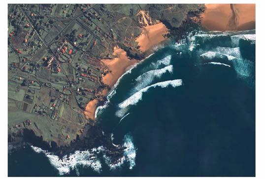
4 Quickbird images Source: DigitalGlobe, Inc Pike Road Longmont, Colorado 80501

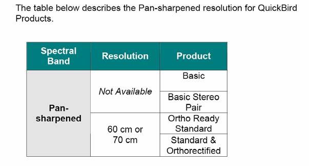
5 Natural Color (Pan-sharpened) Source :DigitalGlobe, Inc Pike Road Longmont, Colorado Synonym: 3-band Pan-sharpened, color Imagery covers the Black & White, Red, Blue, and Green bands. Pan-sharpened using a proprietary algorithm to combine the spatial information of the black and whiteband withthevisual three multispectral bands. All three spectral bands delivered as one image file. informationof

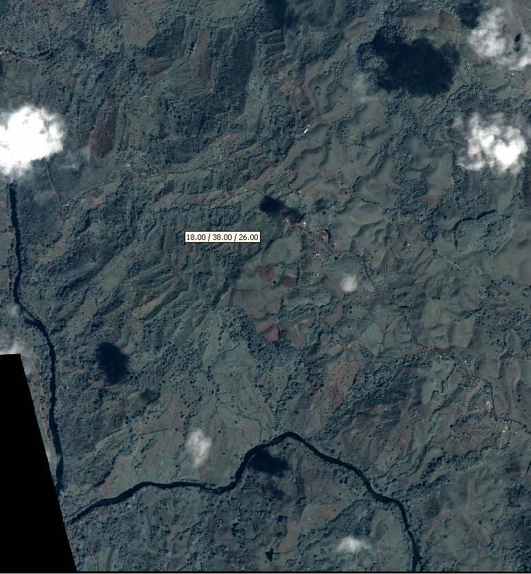
6 Methodology Area of study: The area of study is located in Colombia in the nort-west of Quindio department and in the nort-east of Valle del cauca. The total region has an area of Km2 and it belongs to the municipalitys of Finlandia,Circasia,Armenia,Montenegro,La Tebaida, cartago,alcalá and Ulloa. The area Falls between 950 and 1800 m.a.s.l Taken From Camargo 2005
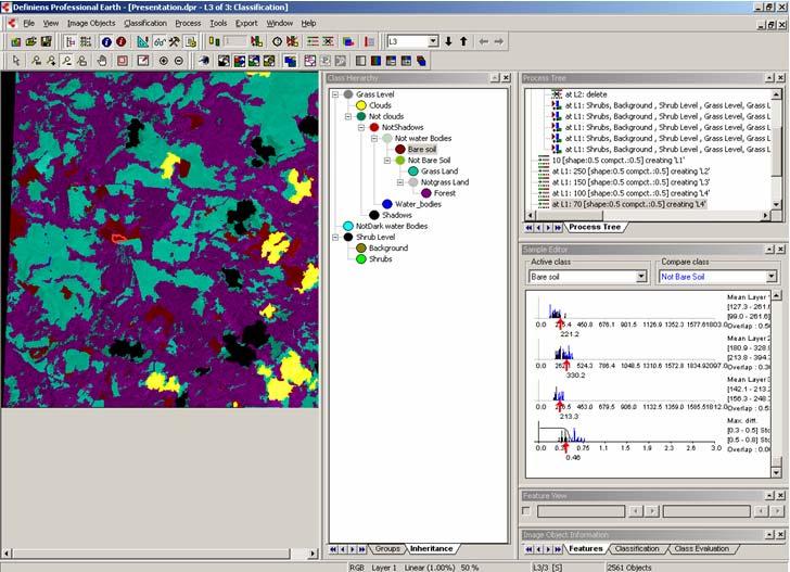
7 Land use Classification methods Pixel based classification Unsupervised classification : K-means unsupervised clustering was selected. Five classes were selected. Supervised classification Five classes were expected to be classified Forest, grassland, bare soil, water bodies and clouds. Object Oriented classification As a first step a segmentation process was executed to divide the images into unclassified objects. These unclassifiedobjects contain information about their spectral characteristic, shape, texture, position and information about their neighbourhood.

8 The workflow of classification consists of the following sequence Source:Defiens Profesional 5 Users Guide


9 Segmentation to Classify clouds, shadows And water bodies Selection of scale,shape And compactness parameters Image Object Hierarchy Selection of rules for an specific class using membership functions

10 Results Pixel Based Unsupervised classification The unsupervised classification presented confuse patterns for all the classes that were included in the analysis procedure. Clouds were easily recognized. Water bodies are dispersed on the whole area It was not even possible to define a legend for the classified areas among the different land cover types.

11 Pixel Based Supervised classification Theoretically a training sample should be just composed of pixels that belong to its corresponding class.
12 Error matrix for Pixel Based Supervised classifiation. Best result After several attempts for the classification. The error matrix shows that 40.47% of the forest area of the training samples could be also classified as grass.forest was also represented in a high percentage by water %. This high representation was observed just between these two types of land covers.


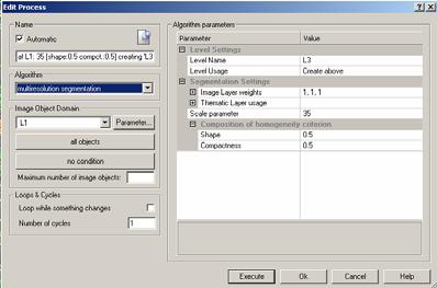
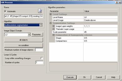
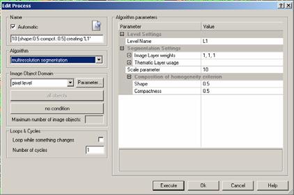
13 Object Oriented Classifiation Different parameters were tested as a trial and error experiment to find the appropriate scale, shape and compactness. The Scale parameter is an abstract term which determines the maximum allowed heterogeneity for the resulting image objects. Applied parameters were. 17 for scale 0,1 for shape, and 0,9 for compactness.


14 Miss classified areas Addition of area and length For the feature domain
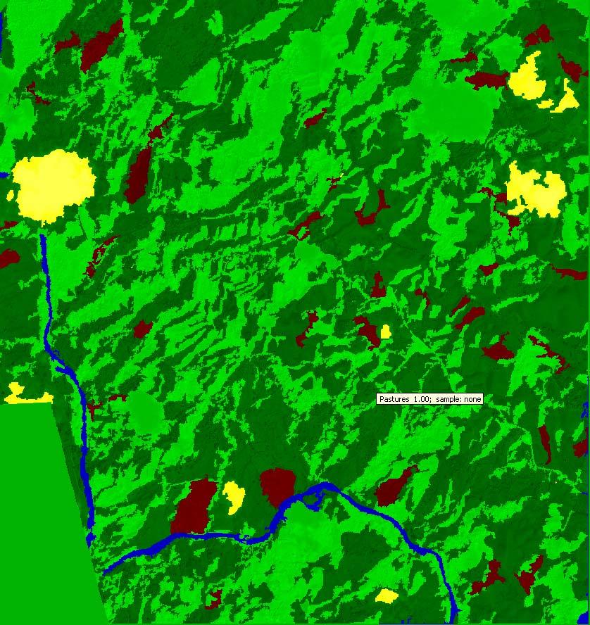
15 Final Classification result


16 Selection of samples Available features for the classification
17

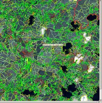
18 Three different segmentation levels for the classification of the area


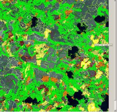
19 Classification of shrubs and trees creating a new segmentation level Miss classified areas are observed for agriculture areas and forest


20 Final classification result with 12 different land use classes


21 Sample editor to compare the spectral Properties of two different classes
22 Conclusions and limitations Several differences among all the methods were found The high resolution of the images produced in both the unsupervised and in the Pixel oriented classification the so called Salt pepper effect Object oriented classification offers a flexible environment for the classification that can be adapted to the specific task. Nonetheless this technique requires an advance knowledge and experience to find the correct parameters for the segmentation that is needed to start with the classification of the area. Pan-sharpened images are absolutely negative for the performance of the computer hardware that is required for the analysis. Therefore it is strictly recommended to work with the original spectral images(multispectral images) with a coarse resolution (2.6 m) and use the panchromatic layer just when additional segmentation processes are needed. Classification results are seriously influenced by the experience of the person. Developing an appropiate set of rules for the classification is a very time consuming activity.
Land Cover Analysis to Determine Areas of Clear-cut and Forest Cover in Olney, Montana. Geob 373 Remote Sensing. Dr Andreas Varhola, Kathry De Rego
 1 Land Cover Analysis to Determine Areas of Clear-cut and Forest Cover in Olney, Montana Geob 373 Remote Sensing Dr Andreas Varhola, Kathry De Rego Zhu an Lim (14292149) L2B 17 Apr 2016 2 Abstract Montana
DISTINGUISHING URBAN BUILT-UP AND BARE SOIL FEATURES FROM LANDSAT 8 OLI IMAGERY USING DIFFERENT DEVELOPED BAND INDICES
 DISTINGUISHING URBAN BUILT-UP AND BARE SOIL FEATURES FROM LANDSAT 8 OLI IMAGERY USING DIFFERENT DEVELOPED BAND INDICES Mark Daryl C. Janiola (1), Jigg L. Pelayo (1), John Louis J. Gacad (1) (1) Central
Keywords: Agriculture, Olive Trees, Supervised Classification, Landsat TM, QuickBird, Remote Sensing.
 Classification of agricultural fields by using Landsat TM and QuickBird sensors. The case study of olive trees in Lesvos island. Christos Vasilakos, University of the Aegean, Department of Environmental
Remote Sensing. Odyssey 7 Jun 2012 Benjamin Post
 Remote Sensing Odyssey 7 Jun 2012 Benjamin Post Definitions Applications Physics Image Processing Classifiers Ancillary Data Data Sources Related Concepts Outline Big Picture Definitions Remote Sensing
Advanced Techniques in Urban Remote Sensing
 Advanced Techniques in Urban Remote Sensing Manfred Ehlers Institute for Geoinformatics and Remote Sensing (IGF) University of Osnabrueck, Germany mehlers@igf.uni-osnabrueck.de Contents Urban Remote Sensing:
AUTOMATIC DETECTION OF HEDGES AND ORCHARDS USING VERY HIGH SPATIAL RESOLUTION IMAGERY
 AUTOMATIC DETECTION OF HEDGES AND ORCHARDS USING VERY HIGH SPATIAL RESOLUTION IMAGERY Selim Aksoy Department of Computer Engineering, Bilkent University, Bilkent, 06800, Ankara, Turkey saksoy@cs.bilkent.edu.tr
Classification in Image processing: A Survey
 Classification in Image processing: A Survey Rashmi R V, Sheela Sridhar Department of computer science and Engineering, B.N.M.I.T, Bangalore-560070 Department of computer science and Engineering, B.N.M.I.T,
Pléiades potentialities :
 GT2 Risque et Aide humanitaire Pléiades potentialities : Assessment of clearing levels for operational management of forest fires in the Maures massif Marechal D., Thierion V., Kabar B., Ayral P.-A., Salze
IMPROVEMENT IN THE DETECTION OF LAND COVER CLASSES USING THE WORLDVIEW-2 IMAGERY
 IMPROVEMENT IN THE DETECTION OF LAND COVER CLASSES USING THE WORLDVIEW-2 IMAGERY Ahmed Elsharkawy 1,2, Mohamed Elhabiby 1,3 & Naser El-Sheimy 1,4 1 Dept. of Geomatics Engineering, University of Calgary
AUTOMATED STAND DELINEATION AND FIRE FUELS MAPPING
 AUTOMATED STAND DELINEATION AND FIRE FUELS MAPPING Jennifer Stefanacci, Director of Geospatial Services Parallel, Incorporated USGS Rocky Mountain Geographic Science Center Denver, CO 80225 jlstefanacci@usgs.gov
CHARACTERISTICS OF REMOTELY SENSED IMAGERY. Spatial Resolution
 CHARACTERISTICS OF REMOTELY SENSED IMAGERY Spatial Resolution There are a number of ways in which images can differ. One set of important differences relate to the various resolutions that images express.
AN OBJECT-ORIENTED CLASSIFICATION METHOD ON HIGH RESOLUTION SATELLITE DATA , China -
 25 th ACRS 2004 Chiang Mai, Thailand 347 AN OBJECT-ORIENTED CLASSIFICATION METHOD ON HIGH RESOLUTION SATELLITE DATA Sun Xiaoxia a Zhang Jixian a Liu Zhengjun a a Chinese Academy of Surveying and Mapping,
Evaluating the Effects of Shadow Detection on QuickBird Image Classification and Spectroradiometric Restoration
 Remote Sens. 2013, 5, 4450-4469; doi:10.3390/rs5094450 Article OPEN ACCESS Remote Sensing ISSN 2072-4292 www.mdpi.com/journal/remotesensing Evaluating the Effects of Shadow Detection on QuickBird Image
Raster is faster but vector is corrector
 Account not required Raster is faster but vector is corrector The old GIS adage raster is faster but vector is corrector comes from the two different fundamental GIS models: vector and raster. Each of
Sommersemester Prof. Dr. Christoph Kleinn Institut für Waldinventur und Waldwachstum Arbeitsbereich Fernerkundung und Waldinventur.
 Basics of Remote Sensing Some literature references Franklin, SE 2001 Remote Sensing for Sustainable Forest Management Lewis Publishers 407p Lillesand, Kiefer 2000 Remote Sensing and Image Interpretation
Textural analysis of coca plantations using 1-meter-resolution remotely-sensed data
 UNODC Workshop, 25-28 November, Bogota, Colombia 1 Textural analysis of coca plantations using 1-meter-resolution remotely-sensed data Workshop on Measurement of Cultivation and Production of Coca Leaves
GEOG432: Remote sensing Lab 3 Unsupervised classification
 GEOG432: Remote sensing Lab 3 Unsupervised classification Goal: This lab involves identifying land cover types by using agorithms to identify pixels with similar Digital Numbers (DN) and spectral signatures
Improvements in Landsat Pathfinder Methods for Monitoring Tropical Deforestation and Their Extension to Extra-tropical Areas
 Improvements in Landsat Pathfinder Methods for Monitoring Tropical Deforestation and Their Extension to Extra-tropical Areas PI: John R. G. Townshend Department of Geography (and Institute for Advanced
Statistical Analysis of SPOT HRV/PA Data
 Statistical Analysis of SPOT HRV/PA Data Masatoshi MORl and Keinosuke GOTOR t Department of Management Engineering, Kinki University, Iizuka 82, Japan t Department of Civil Engineering, Nagasaki University,
IKONOS High Resolution Multispectral Scanner Sensor Characteristics
 High Spatial Resolution and Hyperspectral Scanners IKONOS High Resolution Multispectral Scanner Sensor Characteristics Launch Date View Angle Orbit 24 September 1999 Vandenberg Air Force Base, California,
Urban Feature Classification Technique from RGB Data using Sequential Methods
 Urban Feature Classification Technique from RGB Data using Sequential Methods Hassan Elhifnawy Civil Engineering Department Military Technical College Cairo, Egypt Abstract- This research produces a fully
What can we check with VHR Pan and HR multispectral imagery?
 2008 CwRS Campaign Kick-off meeting, Ispra, 03-04 April 2008 1 What can we check with VHR Pan and HR multispectral imagery? Pavel MILENOV GeoCAP, Agriculture Unit, JRC 2008 CwRS Campaign Kick-off meeting,
EXAMPLES OF OBJECT-ORIENTED CLASSIFICATION PERFORMED ON HIGH-RESOLUTION SATELLITE IMAGES
 EXAMPLES OF OBJECT-ORIENTED CLASSIFICATION... 349 Stanisław Lewiński, Karol Zaremski EXAMPLES OF OBJECT-ORIENTED CLASSIFICATION PERFORMED ON HIGH-RESOLUTION SATELLITE IMAGES Abstract: Information about
Land Cover Type Changes Related to. Oil and Natural Gas Drill Sites in a. Selected Area of Williams County, ND
 Land Cover Type Changes Related to Oil and Natural Gas Drill Sites in a Selected Area of Williams County, ND FR 3262/5262 Lab Section 2 By: Andrew Kernan Tyler Kaebisch Introduction: In recent years, there
Module 11 Digital image processing
 Introduction Geo-Information Science Practical Manual Module 11 Digital image processing 11. INTRODUCTION 11-1 START THE PROGRAM ERDAS IMAGINE 11-2 PART 1: DISPLAYING AN IMAGE DATA FILE 11-3 Display of
Remote sensing in archaeology from optical to lidar. Krištof Oštir ModeLTER Scientific Research Centre of the Slovenian Academy of Sciences and Arts
 Remote sensing in archaeology from optical to lidar Krištof Oštir ModeLTER Scientific Research Centre of the Slovenian Academy of Sciences and Arts Introduction Optical remote sensing Systems Search for
F2 - Fire 2 module: Remote Sensing Data Classification
 F2 - Fire 2 module: Remote Sensing Data Classification F2.1 Task_1: Supervised and Unsupervised classification examples of a Landsat 5 TM image from the Center of Portugal, year 2005 F2.1 Task_2: Burnt
Building Damage Mapping of the 2006 Central Java, Indonesia Earthquake Using High-Resolution Satellite Images
 4th International Workshop on Remote Sensing for Post-Disaster Response, 25-26 Sep. 2006, Cambridge, UK Building Damage Mapping of the 2006 Central Java, Indonesia Earthquake Using High-Resolution Satellite
Cellular automata applied in remote sensing to implement contextual pseudo-fuzzy classication - The Ninth International Conference on Cellular
 INDEX Introduction Spectral and Contextual Classification of Satellite Images Classical aplications of Cellular Automata in Remote Sensing Classification of Satellite Images with Cellular Automata (ACA)
USE OF LANDSAT 7 ETM+ DATA AS BASIC INFORMATION FOR INFRASTRUCTURE PLANNING
 USE OF LANDSAT 7 ETM+ DATA AS BASIC INFORMATION FOR INFRASTRUCTURE PLANNING H. Rüdenauer, M. Schmitz University of Duisburg-Essen, Dept. of Civil Engineering, 45117 Essen, Germany ruedenauer@uni-essen.de,
San Diego State University Department of Geography, San Diego, CA. USA b. University of California, Department of Geography, Santa Barbara, CA.
 1 Plurimondi, VII, No 14: 1-9 Land Cover/Land Use Change analysis using multispatial resolution data and object-based image analysis Sory Toure a Douglas Stow a Lloyd Coulter a Avery Sandborn c David Lopez-Carr
USE OF DIGITAL AERIAL IMAGES TO DETECT DAMAGES DUE TO EARTHQUAKES
 USE OF DIGITAL AERIAL IMAGES TO DETECT DAMAGES DUE TO EARTHQUAKES Fumio Yamazaki 1, Daisuke Suzuki 2 and Yoshihisa Maruyama 3 ABSTRACT : 1 Professor, Department of Urban Environment Systems, Chiba University,
GE 113 REMOTE SENSING
 GE 113 REMOTE SENSING Topic 8. Image Classification and Accuracy Assessment Lecturer: Engr. Jojene R. Santillan jrsantillan@carsu.edu.ph Division of Geodetic Engineering College of Engineering and Information
A Hierarchical Fuzzy Classification Approach for High-Resolution Multispectral Data Over Urban Areas
 1920 IEEE TRANSACTIONS ON GEOSCIENCE AND REMOTE SENSING, VOL. 41, NO. 9, SEPTEMBER 2003 A Hierarchical Fuzzy Classification Approach for High-Resolution Multispectral Data Over Urban Areas Aaron K. Shackelford,
A MULTISTAGE APPROACH FOR DETECTING AND CORRECTING SHADOWS IN QUICKBIRD IMAGERY
 A MULTISTAGE APPROACH FOR DETECTING AND CORRECTING SHADOWS IN QUICKBIRD IMAGERY Jindong Wu, Assistant Professor Department of Geography California State University, Fullerton 800 North State College Boulevard
Image interpretation I and II
 Image interpretation I and II Looking at satellite image, identifying different objects, according to scale and associated information and to communicate this information to others is what we call as IMAGE
VALIDATION OF A SEMI-AUTOMATED CLASSIFICATION APPROACH FOR URBAN GREEN STRUCTURE
 VALIDATION OF A SEMI-AUTOMATED CLASSIFICATION APPROACH FOR URBAN GREEN STRUCTURE Øivind Due Trier a, * and Einar Lieng b a Norwegian Computing Center, Gaustadalléen 23, P.O. Box 114 Blindern, NO-0314 Oslo,
DIGITALGLOBE ATMOSPHERIC COMPENSATION
 See a better world. DIGITALGLOBE BEFORE ACOMP PROCESSING AFTER ACOMP PROCESSING Summary KOBE, JAPAN High-quality imagery gives you answers and confidence when you face critical problems. Guided by our
Abstract Quickbird Vs Aerial photos in identifying man-made objects
 Abstract Quickbird Vs Aerial s in identifying man-made objects Abdullah Mah abdullah.mah@aramco.com Remote Sensing Group, emap Division Integrated Solutions Services Department (ISSD) Saudi Aramco, Dhahran
Compound Object Detection Using Region Co-occurrence Statistics
 Compound Object Detection Using Region Co-occurrence Statistics Selim Aksoy 1 Krzysztof Koperski 2 Carsten Tusk 2 Giovanni Marchisio 2 1 Department of Computer Engineering, Bilkent University, Ankara,
Use of Remote Sensing to Characterize Impervious Cover in Stormwater Impaired Watersheds
 University of Massachusetts Amherst ScholarWorks@UMass Amherst Water Resources Research Center Conferences Water Resources Research Center 4-9-2007 Use of Remote Sensing to Characterize Impervious Cover
C AssesSeg concurrent computing version of AssesSeg: a benchmark between the new and previous version
 C AssesSeg concurrent computing version of AssesSeg: a benchmark between the new and previous version Antonio Novelli 1, Manuel A. Aguilar 2, Fernando J. Aguilar 2, Abderrahim Nemmaoui 2, Eufemia Tarantino
Application of Satellite Image Processing to Earth Resistivity Map
 Application of Satellite Image Processing to Earth Resistivity Map KWANCHAI NORSANGSRI and THANATCHAI KULWORAWANICHPONG Power System Research Unit School of Electrical Engineering Suranaree University
Andrea Baraldi, Luigi Boschetti and Chris Justice. University of Maryland, Dept. of Geographical Sciences, College Park, MD 20740, USA
 Potential for automatic near realtime preliminary classification of Sentinel-2 (and Sentinel-3) imagery using the Satellite Image Automatic Mapper (SIAM ) Andrea Baraldi, Luigi Boschetti and Chris Justice
DEM GENERATION WITH WORLDVIEW-2 IMAGES
 DEM GENERATION WITH WORLDVIEW-2 IMAGES G. Büyüksalih a, I. Baz a, M. Alkan b, K. Jacobsen c a BIMTAS, Istanbul, Turkey - (gbuyuksalih, ibaz-imp)@yahoo.com b Zonguldak Karaelmas University, Zonguldak, Turkey
EVALUATION OF CAPABILITIES OF FUZZY LOGIC CLASSIFICATION OF DIFFERENT KIND OF DATA
 EVALUATION OF CAPABILITIES OF FUZZY LOGIC CLASSIFICATION OF DIFFERENT KIND OF DATA D. Emmolo a, P. Orlando a, B. Villa a a Dipartimento di Rappresentazione, Università degli Studi di Palermo, Via Cavour
Digital Image Classification for Monitoring Landcover
 Digital Image Classification for Monitoring Landcover Trainer Khaled Mashfiq 2 / April / 2018 Training Module A1 Session 2 Advanced Application of Geospatial Information technology for Decision Support
LAND USE MAP PRODUCTION BY FUSION OF MULTISPECTRAL CLASSIFICATION OF LANDSAT IMAGES AND TEXTURE ANALYSIS OF HIGH RESOLUTION IMAGES
 LAND USE MAP PRODUCTION BY FUSION OF MULTISPECTRAL CLASSIFICATION OF LANDSAT IMAGES AND TEXTURE ANALYSIS OF HIGH RESOLUTION IMAGES Xavier OTAZU, Roman ARBIOL Institut Cartogràfic de Catalunya, Spain xotazu@icc.es,
Managing and Monitoring Intertidal Oyster Reefs with Remote Sensing in Coastal South Carolina
 Managing and Monitoring Intertidal Oyster Reefs with Remote Sensing in Coastal South Carolina A cooperative effort between: Coastal Services Center South Carolina Department of Natural Resources City of
DigitalGlobe High Resolution Satellite Imagery
 DigitalGlobe High Resolution Satellite Imagery KIAN KANG, SALES MANAGER, SOUTH EAST ASIA & TAIWAN See a better world. DigitalGlobe Overview Over 1,300 employees spanning the globe H E A D Q UA R T E R
Mapping Open Water Bodies with Optical Remote Sensing
 Mapping Open Water Bodies with Optical Remote Sensing M. O Donnell 1,2 and E. Podest 1 1.Jet Propulsion Laboratory, California Institute of Technology 2 Alliance Gertz-Ressler High School, Los Angeles,
* Tokai University Research and Information Center
 Effects of tial Resolution to Accuracies for t HRV and Classification ta Haruhisa SH Kiyonari i KASA+, uji, and Toshibumi * Tokai University Research and nformation Center 2-28-4 Tomigaya, Shi, T 151,
OBJECT-ORIENTED CHANGE DETECTION OF RIPARIAN ENVIRONMENTS FROM HIGH SPATIAL RESOLUTION MULTI-SPECTRAL IMAGES
 OBJECT-ORIENTED CHANGE DETECTION OF RIPARIAN ENVIRONMENTS FROM HIGH SPATIAL RESOLUTION MULTI-SPECTRAL IMAGES K. Johansen a,b*, L.A. Arroyo a,b, S. Phinn a,b, C. Witte a,c a Joint Remote Sensing Research
Visualizing a Pixel. Simulate a Sensor s View from Space. In this activity, you will:
 Simulate a Sensor s View from Space In this activity, you will: Measure and mark pixel boundaries Learn about spatial resolution, pixels, and satellite imagery Classify land cover types Gain exposure to
COMBINATION OF OBJECT-BASED AND PIXEL-BASED IMAGE ANALYSIS FOR CLASSIFICATION OF VHR IMAGERY OVER URBAN AREAS INTRODUCTION
 COMBINATION OF OBJECT-BASED AND PIXEL-BASED IMAGE ANALYSIS FOR CLASSIFICATION OF VHR IMAGERY OVER URBAN AREAS Bahram Salehi a, PhD Candidate Yun Zhang a, Professor Ming Zhong b, Associates Professor a
Summary. Introduction. Remote Sensing Basics. Selecting a Remote Sensing Product
 K. Dalsted, J.F. Paris, D.E. Clay, S.A. Clay, C.L. Reese, and J. Chang SSMG-40 Selecting the Appropriate Satellite Remote Sensing Product for Precision Farming Summary Given the large number of satellite
Increasing the potential of Razaksat images for map-updating in the Tropics
 IOP Conference Series: Earth and Environmental Science OPEN ACCESS Increasing the potential of Razaksat images for map-updating in the Tropics To cite this article: C Pohl and M Hashim 2014 IOP Conf. Ser.:
Remote Sensing. The following figure is grey scale display of SPOT Panchromatic without stretching.
 Remote Sensing Objectives This unit will briefly explain display of remote sensing image, geometric correction, spatial enhancement, spectral enhancement and classification of remote sensing image. At
A SYNERGETIC USE OF REMOTE-SENSED DATA TO ASSESS THE EVOLUTION OF BURNT AREA BY WILDFIRES IN PORTUGAL
 A SYNERGETIC USE OF REMOTE-SENSED DATA TO ASSESS THE EVOLUTION OF BURNT AREA BY WILDFIRES IN PORTUGAL Teresa J. Calado and Carlos C. DaCamara CGUL, Faculty of Sciences, University of Lisbon, Campo Grande,
Investigating the impact of spatial and spectral resolution of satellite images on segmentation quality
 Investigating the impact of spatial and spectral resolution of satellite images on segmentation quality Nika Mesner Krištof Oštir Investigating the impact of spatial and spectral resolution of satellite
COMPARISON OF INFORMATION CONTENTS OF HIGH RESOLUTION SPACE IMAGES
 COMPARISON OF INFORMATION CONTENTS OF HIGH RESOLUTION SPACE IMAGES H. Topan*, G. Büyüksalih*, K. Jacobsen ** * Karaelmas University Zonguldak, Turkey ** University of Hannover, Germany htopan@karaelmas.edu.tr,
Texture Analysis for Correcting and Detecting Classification Structures in Urban Land Uses i
 Texture Analysis for Correcting and Detecting Classification Structures in Urban Land Uses i Metropolitan area case study Spain Bahaaeddin IZ Alhaddadª, Malcolm C. Burnsª and Josep Roca Claderaª ª Centre
Spectral Signatures of Tombs and their Classification*
 Journal of the Korean Geographical Society, Vol.39, No.2, 2004(283~296) Spectral Signatures of Tombs and their Classification* Eunmi Chang**, Kyeong Park***, and Minho Kim**** * Abstract : More than 0.5
A Survey on Road Extraction from Satellite Images
 127 A Survey on Road Extraction from Satellite Images 1 Reshma Suresh Babu, 2 Radhakrishnan B 1 PG Student, Department Of Computer Science and Engineering, Baselios Mathews II College Of Engineering Sasthamcotta,
In late April of 1986 a nuclear accident damaged a reactor at the Chernobyl nuclear
 CHERNOBYL NUCLEAR POWER PLANT ACCIDENT Long Term Effects on Land Use Patterns Project Introduction: In late April of 1986 a nuclear accident damaged a reactor at the Chernobyl nuclear power plant in Ukraine.
NRS 415 Remote Sensing of Environment
 NRS 415 Remote Sensing of Environment 1 High Oblique Perspective (Side) Low Oblique Perspective (Relief) 2 Aerial Perspective (See What s Hidden) An example of high spatial resolution true color remote
Update on Landsat Program and Landsat Data Continuity Mission
 Update on Landsat Program and Landsat Data Continuity Mission Dr. Jeffrey Masek LDCM Deputy Project Scientist NASA GSFC, Code 923 November 21, 2002 Draft LDCM Implementation Phase RFP Overview Page 1 Celebrate!
Image Analysis based on Spectral and Spatial Grouping
 Image Analysis based on Spectral and Spatial Grouping B. Naga Jyothi 1, K.S.R. Radhika 2 and Dr. I. V.Murali Krishna 3 1 Assoc. Prof., Dept. of ECE, DMS SVHCE, Machilipatnam, A.P., India 2 Assoc. Prof.,
Unsupervised Clustering of EO-1 ALI Panchromatic Data Using Multilevel Local Pattern Histograms and Latent Dirichlet Allocation Classification
 ANALELE UNIVERSITĂłII EFTIMIE MURGU REŞIłA ANUL XVIII, NR., 011, ISSN 1453-7397 Costăchioiu Teodor, Niță Iulian, Lăzărescu Vasile, Datcu Mihai Unsupervised Clustering of EO-1 ALI Panchromatic Data Using
DEVELOPMENT OF A NEW SOUTH AFRICAN LAND-COVER DATASET USING AUTOMATED MAPPING TECHINQUES. Mark Thompson 1
 DEVELOPMENT OF A NEW SOUTH AFRICAN LAND-COVER DATASET USING AUTOMATED MAPPING TECHINQUES. Mark Thompson 1 1 GeoTerraImage Pty Ltd, Pretoria, South Africa Abstract This talk will discuss the development
GEOG432: Remote sensing Lab 3 Unsupervised classification
 GEOG432: Remote sensing Lab 3 Unsupervised classification Goal: This lab involves identifying land cover types by using agorithms to identify pixels with similar Digital Numbers (DN) and spectral signatures
DISCRIMINANT FUNCTION CHANGE IN ERDAS IMAGINE
 DISCRIMINANT FUNCTION CHANGE IN ERDAS IMAGINE White Paper April 20, 2015 Discriminant Function Change in ERDAS IMAGINE For ERDAS IMAGINE, Hexagon Geospatial has developed a new algorithm for change detection
EVALUATION OF THE EXTENSION AND DEGRADATION OF MANGROVE AREAS IN SERGIPE STATE WITH REMOTE SENSING DATA
 EVALUATION OF THE EXTENSION AND DEGRADATION OF MANGROVE ABSTRACT AREAS IN SERGIPE STATE WITH REMOTE SENSING DATA Myrian M. Abdon Ernesto G.M.Vieira Carmem R.S. Espindola Alberto W. Setzer Instituto de
Lecture 13: Remotely Sensed Geospatial Data
 Lecture 13: Remotely Sensed Geospatial Data A. The Electromagnetic Spectrum: The electromagnetic spectrum (Figure 1) indicates the different forms of radiation (or simply stated light) emitted by nature.
Optimizing Multiresolution Segmentation for Extracting Plastic Greenhouses from WorldView 3 Imagery
 Optimizing Multiresolution Segmentation for Extracting Plastic Greenhouses from WorldView 3 Imagery Manuel A. Aguilar, Antonio Novelli, Abderrahim Nemmaoui, Fernando J. Aguilar, Andrés García Lorca, Óscar
Precision Remote Sensing and Image Processing for Precision Agriculture (PA)
") Precision Remote Sensing and Image Processing for Precision Agriculture (PA) Dr. Jack F. Paris Presented to Colorado State University, Fort Collins, CO October 20, 2005 Speaker s Current Activities: Consultant
Precision Remote Sensing and Image Processing for Precision Agriculture (PA) Dr. Jack F. Paris Presented to Colorado State University, Fort Collins, CO October 20, 2005 Speaker s Current Activities: Consultant
TEMPORAL ANALYSIS OF MULTI EPOCH LANDSAT GEOCOVER IMAGES IN ZONGULDAK TESTFIELD
 TEMPORAL ANALYSIS OF MULTI EPOCH LANDSAT GEOCOVER IMAGES IN ZONGULDAK TESTFIELD Şahin, H. a*, Oruç, M. a, Büyüksalih, G. a a Zonguldak Karaelmas University, Zonguldak, Turkey - (sahin@karaelmas.edu.tr,
Texture Feature Extraction for Land-cover Classification of Remote Sensing Data in Land Consolidation District Using Semi-variogram
 Texture Feature Extraction for Land-cover Classification of Remote Sensing Data in Land Consolidation District Using Semi-variogram Anzhi Yue, Su Wei, Daoliang Li, Chao Zhang *, Yan Huang College of Information
Augment the Spatial Resolution of Multispectral Image Using PCA Fusion Method and Classified It s Region Using Different Techniques.
 Augment the Spatial Resolution of Multispectral Image Using PCA Fusion Method and Classified It s Region Using Different Techniques. Israa Jameel Muhsin 1, Khalid Hassan Salih 2, Ebtesam Fadhel 3 1,2 Department
USAGE OF SPECTRAL INDICES IN MONITORING OF GREEN IN THE SELECTED PARTS OF THE PARDUBICE REGION (THE CZECH REPUBLIC)
") USAGE OF SPECTRAL INDICES IN MONITORING OF GREEN IN THE SELECTED PARTS OF THE PARDUBICE REGION (THE CZECH REPUBLIC) Pavel Sedlák, Jitka Komárková, Magdaléna Langerová, Ivana Čermáková Affiliations: Include
USAGE OF SPECTRAL INDICES IN MONITORING OF GREEN IN THE SELECTED PARTS OF THE PARDUBICE REGION (THE CZECH REPUBLIC) Pavel Sedlák, Jitka Komárková, Magdaléna Langerová, Ivana Čermáková Affiliations: Include
Application of Linear Spectral unmixing to Enrique reef for classification
 Application of Linear Spectral unmixing to Enrique reef for classification Carmen C. Zayas-Santiago University of Puerto Rico Mayaguez Marine Sciences Department Stefani 224 Mayaguez, PR 00681 c_castula@hotmail.com
DATA FUSION AND TEXTURE-DIRECTION ANALYSES FOR URBAN STUDIES IN VIETNAM
 1 DATA FUSION AND TEXTURE-DIRECTION ANALYSES FOR URBAN STUDIES IN VIETNAM Tran Dong Binh 1, Weber Christiane 1, Serradj Aziz 1, Badariotti Dominique 2, Pham Van Cu 3 1. University of Louis Pasteur, Department
University of Technology Building & Construction Department / Remote Sensing & GIS lecture
 8. Image Enhancement 8.1 Image Reduction and Magnification. 8.2 Transects (Spatial Profile) 8.3 Spectral Profile 8.4 Contrast Enhancement 8.4.1 Linear Contrast Enhancement 8.4.2 Non-Linear Contrast Enhancement
!!!! Remote Sensing of Roads and Highways in Colorado
 !!!! Remote Sensing of Roads and Highways in Colorado Large-Area Road-Surface Quality and Land-Cover Classification Using Very-High Spatial Resolution Aerial and Satellite Data Contract No. RITARS-12-H-CUB
Overview of how remote sensing is used by the wildland fire community.
 Overview of how remote sensing is used by the wildland fire community. Presented to the ASEN 6210 Remote Sensing Seminar on 2/18/04 by: Jeff Baranyi ESRI Denver Reported by Gary Fager. Images are from
FOREST MAPPING IN MONGOLIA USING OPTICAL AND SAR IMAGES
 FOREST MAPPING IN MONGOLIA USING OPTICAL AND SAR IMAGES D.Enkhjargal 1, D.Amarsaikhan 1, G.Bolor 1, N.Tsetsegjargal 1 and G.Tsogzol 1 1 Institute of Geography and Geoecology, Mongolian Academy of Sciences
APCAS/10/21 April 2010 ASIA AND PACIFIC COMMISSION ON AGRICULTURAL STATISTICS TWENTY-THIRD SESSION. Siem Reap, Cambodia, April 2010
 APCAS/10/21 April 2010 Agenda Item 8 ASIA AND PACIFIC COMMISSION ON AGRICULTURAL STATISTICS TWENTY-THIRD SESSION Siem Reap, Cambodia, 26-30 April 2010 The Use of Remote Sensing for Area Estimation by Robert
Module 3 Introduction to GIS. Lecture 8 GIS data acquisition
 Module 3 Introduction to GIS Lecture 8 GIS data acquisition GIS workflow Data acquisition (geospatial data input) GPS Remote sensing (satellites, UAV s) LiDAR Digitized maps Attribute Data Management Data
Land cover change methods. Ned Horning
 Land cover change methods Ned Horning Version: 1.0 Creation Date: 2004-01-01 Revision Date: 2004-01-01 License: This document is licensed under a Creative Commons Attribution-Share Alike 3.0 Unported License.
Automated GIS data collection and update
 Walter 267 Automated GIS data collection and update VOLKER WALTER, S tuttgart ABSTRACT This paper examines data from different sensors regarding their potential for an automatic change detection approach.
Restoration of Missing Data due to Clouds on Optical Satellite Imagery Using Neural
 Restoration of Missing Data due to Clouds on Optical Satellite Imagery Using Neural Sergii Skakun 1, Nataliia Kussul 1, Ruslan Basarab 2 1 Space Research Institute NAS and SSA Ukraine 2 National University
Remote Sensing And Gis Application in Image Classification And Identification Analysis.
 Quest Journals Journal of Research in Environmental and Earth Science Volume 3~ Issue 5 (2017) pp: 55-66 ISSN(Online) : 2348-2532 www.questjournals.org Research Paper Remote Sensing And Gis Application
USING LANDSAT MULTISPECTRAL IMAGES IN ANALYSING FOREST VEGETATION
 Technical Sciences 243 USING LANDSAT MULTISPECTRAL IMAGES IN ANALYSING FOREST VEGETATION Teodor TODERA teotoderas@yahoo.com Traian CR CEA traiancracea@yahoo.com Alina NEGOESCU alina.negoescu@yahoo.com
Fusion of Heterogeneous Multisensor Data
 Fusion of Heterogeneous Multisensor Data Karsten Schulz, Antje Thiele, Ulrich Thoennessen and Erich Cadario Research Institute for Optronics and Pattern Recognition Gutleuthausstrasse 1 D 76275 Ettlingen
FUNDAMENTALS OF DIGITAL IMAGES
 FUNDAMENTALS OF DIGITAL IMAGES Lecture Image Data Structures Common Data Structures to Store Multiband Data BIL band interleaved by line BSQ band sequential BIP band interleaved by pixel Example Band Band
Basic Digital Image Processing. The Structure of Digital Images. An Overview of Image Processing. Image Restoration: Line Drop-outs
 Basic Digital Image Processing A Basic Introduction to Digital Image Processing ~~~~~~~~~~ Rev. Ronald J. Wasowski, C.S.C. Associate Professor of Environmental Science University of Portland Portland,
Detection of Compound Structures in Very High Spatial Resolution Images
 Detection of Compound Structures in Very High Spatial Resolution Images Selim Aksoy Department of Computer Engineering Bilkent University Bilkent, 06800, Ankara, Turkey saksoy@cs.bilkent.edu.tr Joint work
NORMALIZING ASTER DATA USING MODIS PRODUCTS FOR LAND COVER CLASSIFICATION
 NORMALIZING ASTER DATA USING MODIS PRODUCTS FOR LAND COVER CLASSIFICATION F. Gao a, b, *, J. G. Masek a a Biospheric Sciences Branch, NASA Goddard Space Flight Center, Greenbelt, MD 20771, USA b Earth
An Introduction to Geomatics. Prepared by: Dr. Maher A. El-Hallaq خاص بطلبة مساق مقدمة في علم. Associate Professor of Surveying IUG
 An Introduction to Geomatics خاص بطلبة مساق مقدمة في علم الجيوماتكس Prepared by: Dr. Maher A. El-Hallaq Associate Professor of Surveying IUG 1 Airborne Imagery Dr. Maher A. El-Hallaq Associate Professor
Satellite image classification
 Satellite image classification EG2234 Earth Observation Image Classification Exercise 29 November & 6 December 2007 Introduction to the practical This practical, which runs over two weeks, is concerned