CHARLES MONDELLO PAST PRESIDENT PDC ASPRS FELLOW
|
|
|
- Aubrey Watts
- 5 years ago
- Views:
Transcription


1 SMALL UNMANNED AERIAL SYSTEMS (SUAS) IN EMERGENCY MANAGEMENT RANDY FRANK MARION COUNTY DIRECTOR EMERGENCY MANAGEMENT CHARLES MONDELLO PAST PRESIDENT PDC ASPRS FELLOW
2 SUAS OR DRONE OR UAV 1) Small Unmanned Aerial System 2) Less than 55 pounds 3) An unmanned aerial vehicle (UAV), commonly known as a drone, unmanned aircraft system (UAS), or by several other names, is an aircraft without a human pilot aboard.
3 WHAT CAN A DRONE/SUAS DO? a) Think of it as a tool that can allow you to do different things. b) What you want to accomplish affects the cost, and user interface of the unmanned system. c) Technology changes (monthly) more things become possible. d) Lets explore just a few tools a drone can give you today.
4 WHAT CAN THEY BRING TO THE TABLE? For Emergency Managers it brings a combination of benefits: Increased Situational Awareness Safety Cost Efficiency

5 SITUATIONAL AWARENESS The increased situational awareness allows for better decisions to be made earlier in the process.

6 NATURAL DISASTERS
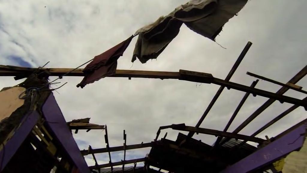
7
8 NATURAL DISASTERS a) Best access to the site b) Areas most impacted c) Direct your resources d) Reach areas with no access

9 NATURAL DISASTERS

10 Reduce the need for people to enter dangerous areas. SAFETY

11 Less expensive than other traditional aerial assets. COST

12 Reach the sight instantly EFFICIENCY Real time video and pictures that can be shared with other first responders.

13 Get everyone the information to make decisions. Find the problem fast. No need to wait for aerial support. EFFICIENCY
14 How many contract aerial or satellite photography for assessment or in a catastrophe? 14
15 If you intend to do the work yourself with a UAS you are now a pilot, image processor, imaging scientist, data manager, and lawyer 15


16 The type of UAS chosen will be based on mission requirements and rely heavily on payload and area coverage 16

17 A sensors equipped UAV constitute a UAS: Unmanned Airborne System. Multi rotor are defined often by rotor configuration and number of motors 17

18 Sensors should be mounted on a vibration stabilized gimbal mount to insure high quality data capture 18

19 Imaging Define the deliverable is the first step Defining what is to be captured? Does the end product require sensor fusion? Is it a simple image or an extended data set? Is it visualization or authoritative?


20 Imaging Metrics Spatial and Spectral metrics define what can be resolved by a sensor given understating of the device, imaging conditions, and the target 20

21 Sensors can see details when specified accurately. Focal length, field of view all work in conjunction with the operations envelope 21

22 Multiple Aspects of Making the Correct Data Set (Pun intended) Orthophoto, Oblique, 3D, Elevation, Planimetrics, Other? Authoritative or Visualization We will not be doing the math today 22

23 Spatial Metrics define the resolution "possible" from a UAS Understand Capture metrics H = Height GSD= Ground Sample Distance F P = Focal Length = Pixel = Picture element This is meant to be here... A white target On a white background doesn t work Despite the resolution Modulation transfer function = MTF 23


24 Resolution on Targets depend on Background as well 24

25 Sensors can see details when specified accurately. Focal length, field of view all work in conjunction with the operations envelope 25


26 Sample Resolution versus Area UAS can be a fraction of an inch Ground Sample Distance (GSD)in a comparatively small coverage footprint Inches Feet
27 Steps to measure Similar Triangles Pixel To find any unknown Have 3 of :P FL H or GSD Calculate the unknown using similar triangles Key is to divide common units Sample focal length of the lens: 12mm Sample pixel size for the camera is 8microns A micron is 1000 th of a mm so to keep common units 0.008mm should be used Focal length Height GSD 27

28 Spectral Metrics in UAS Data capture Defines the understanding of imaging in terms of the electromagnetic spectrum 28


29 Sensors can see more than the eye and classify different materials in an automated fashion 29
30 The Spectral Bands Approximate bandpass Blue, nm, is used for atmosphere and deep water imaging, and can reach depths up to 150 feet (50 m) in clear water Green, nm, is used for imaging vegetation and deep water structures, up to 90 feet (30 m) in clear water Red, nm, is used for imaging man-made objects, in water up to 30 feet (9 m) deep, soil, and vegetation Near infrared, nm, red edge for reflected chlorophyll imaging vegetation SWIR nm, is used for imaging vegetation, soil moisture content, and some forest fires MWIR 3-5microns half emitted half reflected IR cross between solar and target radiated data Thermal infrared, 8-12 microns, uses emitted instead of reflected radiation thermal characterization 30


31 Common Spectral Bands Groupings Pan Chromatic an aggregation of all bands seen by the sensor into a single wide band shown often as B&W image RGB Red-Green-Blue or True-color uses only red, green, and blue channels, mapped to same colors. As a Standard color image, traditional imaging Green-red-infrared, where the blue channel has a yellow filer applied and no IR blocking to permit capture as NIR. is used for vegetation, which is highly reflective in near IR, NDVI is used to show the infrared to red green ratio 31


32 TECHNOLOGIES OF A UAS EVOLVES FROM OUTSIDE SOURCES Your Phone is a great indicator of the drone s technology Inertial Compass GPS Camera Transmit Receive Display Firmware/OS/Apps CPU Storage 32
33 In most cases the success of a drone mission will only be as good as the images or data you can show 33


34 Many terms have their roots in traditional imaging ISO S P AE M EV A 34

35 Many terms have their roots in traditional imaging ISO: American Standards Association, but now ISO, Int l Org for Standardization Gain: More isn t always better based on signal to noise S: Shutter speed, 1/x seconds, key to the degree of blur P: Program, often lets system pick what's best mix of gain, shutter & aperture AE: Auto Expose lock keeps the settings fixed versus floating for best exposure M: Manual aka the operator knows what's best, example shadowed or high glare EV: Exposure Value represents a combination of shutter speed and aperture that give the same exposure have the same result. A good tool is EV Bias in which you can set a trend or bracket exposures automatically A: Aperture is the opening in the lens that lets in the light The f-stop or F/N indicates degree of aperture opening F-stop is the focal length divided by the diameter of the lens Depth of field and in some cases distortion 35
36 Missing Persons SCENARIOS FOR SUAS Natural Disasters Man-made Disasters Support for Fire and Police Accident Reconstruction Aerial Documentation and Surveying Reach difficult areas
37 Using Geotagged images Using Live video feeds Search Patterns Then Processing data Data storage and access Policy and Procedures HOW TO INTEGRATE DRONES INTO EMERGENCY MANAGEMENT?

38 SUAS WORK FLOW First Responder Drone Pilot Incident Commander (Increased Situational Awareness to make better decisions)
39 CHALLENGES Technical Dual Cameras (Zoom/Thermal) Battery Life Weather (Wind/Rain) Streaming/sharing data Other Knowing how to best use the drone Getting everyone on board Keeping a positive public view on its use
40 COA s vs Part 107 TRAINING AND WHAT ARE THE RULES FOR FLYING?
41 PUBLIC COA Positives More flexibility in your operation Easier to get permission to fly in large controlled airspace (Kansas City class B) Self train your pilots Negatives Monthly Reports Takes more time and paperwork to complete ( days) Aircraft specific

42 September 2016, Part Rules for Commercial use of suas PART 107

43 PART 107 Remote Pilot Certificate allows you to operate suas commercially. Positives Easy to obtain Not specific to your department. Easier to obtain insurance Standardized training Part 107 was designed to be flexible Negatives Need authorization to fly in controlled airspace.(2 4 weeks) Need waiver for night flying (30 90 days)
44 HOW ABOUT FLIGHT TRAINING? None required Knowledge of the equipment and systems Batteries Cold/Hot weather flying Limitations Easy to fly
45 WHICH DIRECTION IS SUAS MOVING? New technology Drones designed for specific needs Software to make your job easy New Rules Less strict Lots of learning Changing every day Many benefits
46 RECENT SUAS EVENTS

47 US military bases have been given permission to shoot down drones when appropriate
 Cease all use of DJI Drones on Army Installations 2) Uninstall all DJI applications 3) Remove all batteries/storage")
48 a) April 2017 It became illegal to fly personal drones within 400ft (122m) of the US's 133 military facilities b) August 2, 2017; Army Air Directorate's Deputy Chief of Staff Lt. General Joseph Anderson issued an Office Memorandum ordering the following: 1) Cease all use of DJI Drones on Army Installations 2) Uninstall all DJI applications 3) Remove all batteries/storage media from devices 4) Secure equipment for follow-on direction 5) The Pentagon has given US military bases permission to shoot down or otherwise destroy consumer drones flying overhead and nearby Military Bases
49 CURRENT PROECTS
50 Marion County Kansas Emergency Management Agency (MN EMA) in partnership with the Property Drone Consortium (PDC) are working jointly with the Department of Homeland Security (DHS) on a Cooperative Research and Development Agreement (CRADA). The Federal CRADA Partners will collaborate with PDC to leverage knowledge, assets and other resources toward joint conduct of research with the goal of advancing small unmanned aerial systems (suas) education for public safety. The evaluation will focus on beginning use of suas to support public safety missions, testing, evaluation and training. The end result will be the development of a document that directs, educates and instructs the private sector on how to safely interact and work with public safety efforts for the benefit of all parties.
51 TARGET AUDIENCE Federal, State and Local Emergency Services in conjunction with private organizations and non-government organizations (NGOs) who respond to natural or manmade disasters within the United States or America and its Territories.
52 RISK/OPPORTUNITY 1. Working with the Federal Aviation Administration (FAA) using Small Unmanned Aircraft Systems (suas). 2. Fulfilling all laws and rules of the FAA. 3. Identify a structure that will be used for suas during a declared disaster which will ensure safety of manned aircraft, suas, hobbyist and the general public. 4. Provide structure for all aircraft to deploy while not limiting lifesaving and emergency response aircraft. 5. Provide an avenue for emergency responders to locate missing persons both during the day and at night. 6. Identifying the areas of disaster damage so that responders can focus their efforts. 7. Integrate the suas as a part of a Standard Operating Guidelines (SOG). 8. Identify types of training for suas pilots for disaster response. 9. Identify types and quantity of equipment needed for response.
53 CONCLUSIONS It is clear that the role of SUAS and the growing need in the emergency services sector with respects to future enhancements of technology in the near future will increase substantially. Technological challenges that will need to be overcome are longer flight times and the ability to sustain higher wind speeds. During the Full Scale Exercise we will be able to identify strengths and challenges in responding to a disaster while using suas. These aircraft are quickly becoming the symbol of disaster response as they are used for identifying areas of debris removal and locate survivors in the disaster area. The access to the images from the suas will assist response leadership teams with a more accurate situational awareness and which will uphold the Disaster Response Plan.
54 QUESTIONS?
MULTISPECTRAL AGRICULTURAL ASSESSMENT. Normalized Difference Vegetation Index. Federal Robotics INSPECTION & DOCUMENTATION
 MULTISPECTRAL AGRICULTURAL ASSESSMENT Normalized Difference Vegetation Index INSPECTION & DOCUMENTATION Federal Robotics Clearwater Dr. Amherst, New York 14228 716-221-4181 Sales@FedRobot.com www.fedrobot.com
Phase One 190MP Aerial System
 White Paper Phase One 190MP Aerial System Introduction Phase One Industrial s 100MP medium format aerial camera systems have earned a worldwide reputation for its high performance. They are commonly used
RPAS Photogrammetric Mapping Workflow and Accuracy
 RPAS Photogrammetric Mapping Workflow and Accuracy Dr Yincai Zhou & Dr Craig Roberts Surveying and Geospatial Engineering School of Civil and Environmental Engineering, UNSW Background RPAS category and
Overview. Objectives. The ultimate goal is to compare the performance that different equipment offers us in a photogrammetric flight.
 Overview At present, one of the most commonly used technique for topographic surveys is aerial photogrammetry. This technique uses aerial images to determine the geometric properties of objects and spatial
REMOTE SENSING WITH DRONES. YNCenter Video Conference Chang Cao
 REMOTE SENSING WITH DRONES YNCenter Video Conference Chang Cao 08-28-2015 28 August 2015 2 Drone remote sensing It was first utilized in military context and has been given great attention in civil use
Aerial photography and Remote Sensing. Bikini Atoll, 2013 (60 years after nuclear bomb testing)
") Aerial photography and Remote Sensing Bikini Atoll, 2013 (60 years after nuclear bomb testing) Computers have linked mapping techniques under the umbrella term : Geomatics includes all the following spatial
Aerial photography and Remote Sensing Bikini Atoll, 2013 (60 years after nuclear bomb testing) Computers have linked mapping techniques under the umbrella term : Geomatics includes all the following spatial
MSB Imagery Program FAQ v1
 MSB Imagery Program FAQ v1 (F)requently (A)sked (Q)uestions 9/22/2016 This document is intended to answer commonly asked questions related to the MSB Recurring Aerial Imagery Program. Table of Contents
Crop Scouting with Drones Identifying Crop Variability with UAVs
 DroneDeploy Crop Scouting with Drones Identifying Crop Variability with UAVs A Guide to Evaluating Plant Health and Detecting Crop Stress with Drone Data Table of Contents 01 Introduction Crop Scouting
Customer Showcase > Defense and Intelligence
 Customer Showcase Skyline TerraExplorer is a critical visualization technology broadly deployed in defense and intelligence, public safety and security, 3D geoportals, and urban planning markets. It fuses
Aerial Image Acquisition and Processing Services. Ron Coutts, M.Sc., P.Eng. RemTech, October 15, 2014
 Aerial Image Acquisition and Processing Services Ron Coutts, M.Sc., P.Eng. RemTech, October 15, 2014 Outline Applications & Benefits Image Sources Aircraft Platforms Image Products Sample Images & Comparisons
Drones and Ham Radio. Bob Schatzman KD9AAD
 Drones and Ham Radio Bob Schatzman KD9AAD Not Your Childhood RC Toy! Highly Accurate GPS receiver! Magnetic Compass! R/C Transmitter/Receiver! Accelerometers/Gyros! HDTV & HQ Still Camera on a Smart Gimbal!
Rochester Institute of Technology. Wildfire Airborne Sensor Program (WASP) Project Overview
 Project Overview") Rochester Institute of Technology Wildfire Airborne Sensor Program (WASP) Project Overview Introduction The following slides describe a program underway at RIT The sensor system described herein is being
Rochester Institute of Technology Wildfire Airborne Sensor Program (WASP) Project Overview Introduction The following slides describe a program underway at RIT The sensor system described herein is being
AIRPORT MAPPING JUNE 2016 EXPLORING UAS EFFECTIVENESS GEOSPATIAL SLAM TECHNOLOGY FEMA S ROMANCE WITH LIDAR VOLUME 6 ISSUE 4
 VOLUME 6 ISSUE 4 JUNE 2016 AIRPORT MAPPING 18 EXPLORING UAS EFFECTIVENESS 29 GEOSPATIAL SLAM TECHNOLOGY 36 FEMA S ROMANCE WITH LIDAR Nearly 2,000 U.S. landfill facilities stand to gain from cost-effective
Choosing the Best Optical Filter for Your Application. Georgy Das Midwest Optical Systems, Inc.
 Choosing the Best Optical Filter for Your Application Georgy Das Midwest Optical Systems, Inc. Filters are a Necessity, Not an Accessory. Key Terms Transmission (%) 100 90 80 70 60 50 40 30 20 10 OUT-OF-BAND
An Introduction to Geomatics. Prepared by: Dr. Maher A. El-Hallaq خاص بطلبة مساق مقدمة في علم. Associate Professor of Surveying IUG
 An Introduction to Geomatics خاص بطلبة مساق مقدمة في علم الجيوماتكس Prepared by: Dr. Maher A. El-Hallaq Associate Professor of Surveying IUG 1 Airborne Imagery Dr. Maher A. El-Hallaq Associate Professor
Remote Sensing Platforms
 Types of Platforms Lighter-than-air Remote Sensing Platforms Free floating balloons Restricted by atmospheric conditions Used to acquire meteorological/atmospheric data Blimps/dirigibles Major role - news
USE OF IMPROVISED REMOTELY SENSED DATA FROM UAV FOR GIS AND MAPPING, A CASE STUDY OF GOMA CITY, DR CONGO
 USE OF IMPROVISED REMOTELY SENSED DATA FROM UAV FOR GIS AND MAPPING, A CASE STUDY OF GOMA CITY, DR CONGO Cung Chin Thang United Nations Global Support Center, Brindisi, Italy, Email: thang@un.org KEY WORDS:
Lecture 13: Remotely Sensed Geospatial Data
 Lecture 13: Remotely Sensed Geospatial Data A. The Electromagnetic Spectrum: The electromagnetic spectrum (Figure 1) indicates the different forms of radiation (or simply stated light) emitted by nature.
AERIAL SURVEY TEST PROJECT WITH DJI PHANTOM 3 QUADROCOPTER DRONE
 T. Jancso, P. Engler, P. Udvardy Aerial Survey Test Project with DJI Phantom 3 Quadrocopter Drone AERIAL SURVEY TEST PROJECT WITH DJI PHANTOM 3 QUADROCOPTER DRONE Tamas JANCSO, Associate Professor Phd
An NDVI image provides critical crop information that is not visible in an RGB or NIR image of the same scene. For example, plants may appear green
 Normalized Difference Vegetation Index (NDVI) Spectral Band calculation that uses the visible (RGB) and near-infrared (NIR) bands of the electromagnetic spectrum NDVI= + An NDVI image provides critical
LAST GENERATION UAV-BASED MULTI- SPECTRAL CAMERA FOR AGRICULTURAL DATA ACQUISITION
 LAST GENERATION UAV-BASED MULTI- SPECTRAL CAMERA FOR AGRICULTURAL DATA ACQUISITION FABIO REMONDINO, Erica Nocerino, Fabio Menna Fondazione Bruno Kessler Trento, Italy http://3dom.fbk.eu Marco Dubbini,
Monitoring the vegetation success of a rehabilitated mine site using multispectral UAV imagery. Tim Whiteside & Renée Bartolo, eriss
 Monitoring the vegetation success of a rehabilitated mine site using multispectral UAV imagery Tim Whiteside & Renée Bartolo, eriss About the Supervising Scientist Main roles Working to protect the environment
Remote Sensing Platforms
 Remote Sensing Platforms Remote Sensing Platforms - Introduction Allow observer and/or sensor to be above the target/phenomena of interest Two primary categories Aircraft Spacecraft Each type offers different
Module 3 Introduction to GIS. Lecture 8 GIS data acquisition
 Module 3 Introduction to GIS Lecture 8 GIS data acquisition GIS workflow Data acquisition (geospatial data input) GPS Remote sensing (satellites, UAV s) LiDAR Digitized maps Attribute Data Management Data
PRODUCT OVERVIEW FOR THE. Corona 350 II FLIR SYSTEMS POLYTECH AB
 PRODUCT OVERVIEW FOR THE Corona 350 II FLIR SYSTEMS POLYTECH AB Table of Contents Table of Contents... 1 Introduction... 2 Overview... 2 Purpose... 2 Airborne Data Acquisition and Management Software (ADAMS)...
VisionMap A3 Edge A Single Camera for Multiple Solutions
 Photogrammetric Week '15 Dieter Fritsch (Ed.) Wichmann/VDE Verlag, Belin & Offenbach, 2015 Raizman, Gozes 57 VisionMap A3 Edge A Single Camera for Multiple Solutions Yuri Raizman, Adi Gozes, Tel-Aviv ABSTRACT
TRUESENSE SPARSE COLOR FILTER PATTERN OVERVIEW SEPTEMBER 30, 2013 APPLICATION NOTE REVISION 1.0
 TRUESENSE SPARSE COLOR FILTER PATTERN OVERVIEW SEPTEMBER 30, 2013 APPLICATION NOTE REVISION 1.0 TABLE OF CONTENTS Overview... 3 Color Filter Patterns... 3 Bayer CFA... 3 Sparse CFA... 3 Image Processing...
Countering Weapons of Mass Destruction (CWMD) Capability Assessment Event (CAE)
 Capability Assessment Event (CAE)") Countering Weapons of Mass Destruction (CWMD) Capability Assessment Event (CAE) Overview 08-09 May 2019 Submit NLT 22 March On 08-09 May, SOFWERX, in collaboration with United States Special Operations
Countering Weapons of Mass Destruction (CWMD) Capability Assessment Event (CAE) Overview 08-09 May 2019 Submit NLT 22 March On 08-09 May, SOFWERX, in collaboration with United States Special Operations
PEGASUS : a future tool for providing near real-time high resolution data for disaster management. Lewyckyj Nicolas
 PEGASUS : a future tool for providing near real-time high resolution data for disaster management Lewyckyj Nicolas nicolas.lewyckyj@vito.be http://www.pegasus4europe.com Overview Vito in a nutshell GI
FOR 353: Air Photo Interpretation and Photogrammetry. Lecture 2. Electromagnetic Energy/Camera and Film characteristics
 FOR 353: Air Photo Interpretation and Photogrammetry Lecture 2 Electromagnetic Energy/Camera and Film characteristics Lecture Outline Electromagnetic Radiation Theory Digital vs. Analog (i.e. film ) Systems
RECONNAISSANCE PAYLOADS FOR RESPONSIVE SPACE
 3rd Responsive Space Conference RS3-2005-5004 RECONNAISSANCE PAYLOADS FOR RESPONSIVE SPACE Charles Cox Stanley Kishner Richard Whittlesey Goodrich Optical and Space Systems Division Danbury, CT Frederick
FLIGHT SUMMARY REPORT
 FLIGHT SUMMARY REPORT Flight Number: 97-011 Calendar/Julian Date: 23 October 1996 297 Sensor Package: Area(s) Covered: Wild-Heerbrugg RC-10 Airborne Visible and Infrared Imaging Spectrometer (AVIRIS) Southern
UAV Technologies for 3D Mapping. Rolf Schaeppi Director Geospatial Solutions APAC / India
 UAV Technologies for 3D Mapping Rolf Schaeppi Director Geospatial Solutions APAC / India Some main application areas? Market situation Analyst statements billion dollars 7,3 defense market 2,5 civil market
An Introduction to Remote Sensing & GIS. Introduction
 An Introduction to Remote Sensing & GIS Introduction Remote sensing is the measurement of object properties on Earth s surface using data acquired from aircraft and satellites. It attempts to measure something
How Farmer Can Utilize Drone Mapping?
 Presented at the FIG Working Week 2017, May 29 - June 2, 2017 in Helsinki, Finland How Farmer Can Utilize Drone Mapping? National Land Survey of Finland Finnish Geospatial Research Institute Roope Näsi,
Validation of the QuestUAV PPK System
 Validation of the QuestUAV PPK System 3cm in xy, 400ft, no GCPs, 100Ha, 25 flights Nigel King 1, Kerstin Traut 2, Cameron Weeks 3 & Ruairi Hardman 4 1 Director QuestUAV, 2 Data Analyst QuestUAV, 3 Production
MSRC Tactical Oil Spill Surveillance and Remote Sensing
 MSRC Tactical Oil Spill Surveillance and Remote Sensing Industry Technical Advisory Committee for Oil spill Response October 25, 2016 0 Historical Perspective -- Oil Spill Surveillance in U.S Exxon Valdez
Vegetation Indexing made easier!
 Remote Sensing Vegetation Indexing made easier! TETRACAM MCA & ADC Multispectral Camera Systems TETRACAM MCA and ADC are multispectral cameras for critical narrow band digital photography. Based on the
Unmanned Aerial Vehicles: A New Approach for Coastal Habitat Assessment
 Unmanned Aerial Vehicles: A New Approach for Coastal Habitat Assessment David Ryan Principal Marine Scientist WorleyParsons Western Operations 2 OUTLINE Importance of benthic habitat assessment. Common
AERIAL PHOTOGRAPHY AND THE USE OF PHOTO CAMERAS ATTACHED TO DRONES
 AERIAL SYSTEMS AND AEROSPACE ENGINEERING AERIAL PHOTOGRAPHY AND THE USE OF PHOTO CAMERAS ATTACHED TO DRONES Mihai RADULESCU, Victor VLADAREANU Institute of Solid Mechanics of the Romanian Academy (mih_rad@yahoo.com)
Digital Aerial Photography UNBC March 22, Presented by: Dick Mynen TDB Consultants Inc.
 Digital Aerial Photography UNBC March 22, 2011 Presented by: Dick Mynen TDB Consultants Inc. Airborne Large Scale Digital Photography Who is using the technology in today s environment Options available
Using Unmanned Aircraft Systems for Communications Support
 A NPSTC Public Safety Communications Report Using Unmanned Aircraft Systems for Communications Support NPSTC Technology and Broadband Committee Unmanned Aircraft Systems and Robotics Working Group National
All About Drone Photography
 All About Drone Photography What is Drone? Originally Drones were developed and used by the military and used for reconnaissance, targe
Compact Dual Field-of-View Telescope for Small Satellite Payloads
 Compact Dual Field-of-View Telescope for Small Satellite Payloads James C. Peterson Space Dynamics Laboratory 1695 North Research Park Way, North Logan, UT 84341; 435-797-4624 Jim.Peterson@sdl.usu.edu
Developing GeoINT (Geospatial Intelligence) and UAS (Drone) Courses and Programs
 and UAS (Drone) Courses and Programs") Developing GeoINT (Geospatial Intelligence) and UAS (Drone) Courses and Programs Vincent A. DiNoto, Jr. Director of GeoTech Center Vince.dinoto@kctcs.edu Based upon work supported by the National Science
Developing GeoINT (Geospatial Intelligence) and UAS (Drone) Courses and Programs Vincent A. DiNoto, Jr. Director of GeoTech Center Vince.dinoto@kctcs.edu Based upon work supported by the National Science
Scaling Up Drone Science for Agriculture & Nature Resources through Cooperative Extension
 Scaling Up Drone Science for Agriculture & Nature Resources through Cooperative Extension Andy Lyons, Maggi Kelly, Sean Hogan, Shane Feirer, Robert Johnson CalGIS 2017, Oakland, CA. May 23, 2017 How and
sensefly Camera Collection
 Camera Collection A professional sensor for every application Introducing S.O.D.A. 3D 3D mapping, redefined Image: S.O.D.A. 3D oblique image (left) merging into 3D mesh (right). Stunning digital 3D reconstructions
VisionMap Sensors and Processing Roadmap
 Vilan, Gozes 51 VisionMap Sensors and Processing Roadmap YARON VILAN, ADI GOZES, Tel-Aviv ABSTRACT The A3 is a family of digital aerial mapping cameras and photogrammetric processing systems, which is
How to Access Imagery and Carry Out Remote Sensing Analysis Using Landsat Data in a Browser
 How to Access Imagery and Carry Out Remote Sensing Analysis Using Landsat Data in a Browser Including Introduction to Remote Sensing Concepts Based on: igett Remote Sensing Concept Modules and GeoTech
Satellite Imagery and Remote Sensing. DeeDee Whitaker SW Guilford High EES & Chemistry
 Satellite Imagery and Remote Sensing DeeDee Whitaker SW Guilford High EES & Chemistry whitakd@gcsnc.com Outline What is remote sensing? How does remote sensing work? What role does the electromagnetic
UAV applications for oil spill detection, suspended matter distribution and ice monitoring first tests and trials in Estonia 2015/2016
 UAV applications for oil spill detection, suspended matter distribution and ice monitoring first tests and trials in Estonia 2015/2016 Sander Rikka Marine Systems Institute at TUT 1.11.2016 1 Outlook Introduction
Geo-localization and Mosaicing System (GEMS): Enabling Precision Image Feature Location and Rapid Mosaicing General:
: Enabling Precision Image Feature Location and Rapid Mosaicing General:") Geo-localization and Mosaicing System (GEMS): Enabling Precision Image Feature Location and Rapid Mosaicing General: info@senteksystems.com www.senteksystems.com 12/6/2014 Precision Agriculture Multi-Spectral
Geo-localization and Mosaicing System (GEMS): Enabling Precision Image Feature Location and Rapid Mosaicing General: info@senteksystems.com www.senteksystems.com 12/6/2014 Precision Agriculture Multi-Spectral
SFR 406 Spring 2015 Lecture 7 Notes Film Types and Filters
 SFR 406 Spring 2015 Lecture 7 Notes Film Types and Filters 1. Film Resolution Introduction Resolution relates to the smallest size features that can be detected on the film. The resolving power is a related
Valuable New Information for Precision Agriculture. Mike Ritter Founder & CEO - SLANTRANGE, Inc.
 Valuable New Information for Precision Agriculture Mike Ritter Founder & CEO - SLANTRANGE, Inc. SENSORS Accurate, Platform- Agnostic ANALYTICS On-Board, On-Location SLANTRANGE Delivering Valuable New Information
REMOTE SENSING. Topic 10 Fundamentals of Digital Multispectral Remote Sensing MULTISPECTRAL SCANNERS MULTISPECTRAL SCANNERS
 REMOTE SENSING Topic 10 Fundamentals of Digital Multispectral Remote Sensing Chapter 5: Lillesand and Keifer Chapter 6: Avery and Berlin MULTISPECTRAL SCANNERS Record EMR in a number of discrete portions
Remote Sensing is the observation of the Earth from satellites or aircrafts.
 Remote Sensing? Remote Sensing is the observation of the Earth from satellites or aircrafts. Sensors mounted on these platforms capture images of the Earth that reveal features may or may not apparent
Five Sensors, One Day: Unmanned vs. Manned Logistics and Accuracy
 Five Sensors, One Day: Unmanned vs. Manned Logistics and Accuracy ASPRS UAS Mapping Technical Symposium Sept 13 th, 2016 Presenter: David Day, CP, GISP Keystone Aerial Surveys, Inc. Summary of activities
746A27 Remote Sensing and GIS
 746A27 Remote Sensing and GIS Lecture 1 Concepts of remote sensing and Basic principle of Photogrammetry Chandan Roy Guest Lecturer Department of Computer and Information Science Linköping University What
Brian Arnall Precision Nutrient Management Oklahoma State University
 A Down to Earth Look at UAVs in Agriculture Brian Arnall Precision Nutrient Management Oklahoma State University Ok State has provided cease and desist. I have not flown one. I am very familiar with their
Introduction of Satellite Remote Sensing
 Introduction of Satellite Remote Sensing Spatial Resolution (Pixel size) Spectral Resolution (Bands) Resolutions of Remote Sensing 1. Spatial (what area and how detailed) 2. Spectral (what colors bands)
MANNED AIRBORNE REAL-TIME SURVEILLANCE OBSERVATION SYSTEM
 MARSO WWW.MARSO.AERO MANNED AIRBORNE REAL-TIME SURVEILLANCE OBSERVATION & SYSTEM THE MARSO SYSTEM is a versatile surveillance system for a large class of missions ranging from large area ship detection
HALS-H1 Ground Surveillance & Targeting Helicopter
 ARATOS-SWISS Homeland Security AG & SMA PROGRESS, LLC HALS-H1 Ground Surveillance & Targeting Helicopter Defense, Emergency, Homeland Security (Border Patrol, Pipeline Monitoring)... Automatic detection
PHOTOGRAMMETRY STEREOSCOPY FLIGHT PLANNING PHOTOGRAMMETRIC DEFINITIONS GROUND CONTROL INTRODUCTION
 PHOTOGRAMMETRY STEREOSCOPY FLIGHT PLANNING PHOTOGRAMMETRIC DEFINITIONS GROUND CONTROL INTRODUCTION Before aerial photography and photogrammetry became a reliable mapping tool, planimetric and topographic
The Hyperspectral UAV (HyUAV) a novel UAV-based spectroscopy tool for environmental monitoring
 a novel UAV-based spectroscopy tool for environmental monitoring") The Hyperspectral UAV (HyUAV) a novel UAV-based spectroscopy tool for environmental monitoring R. Garzonio 1, S. Cogliati 1, B. Di Mauro 1, A. Zanin 2, B. Tattarletti 2, F. Zacchello 2, P. Marras 2 and
The Hyperspectral UAV (HyUAV) a novel UAV-based spectroscopy tool for environmental monitoring R. Garzonio 1, S. Cogliati 1, B. Di Mauro 1, A. Zanin 2, B. Tattarletti 2, F. Zacchello 2, P. Marras 2 and
Detection and Monitoring Through Remote Sensing....The Need For A New Remote Sensing Platform
 WILDFIRES Detection and Monitoring Through Remote Sensing...The Need For A New Remote Sensing Platform Peter Kimball ASEN 5235 Atmospheric Remote Sensing 5/1/03 1. Abstract This paper investigates the
The drone for precision agriculture
 The drone for precision agriculture Reap the benefits of scouting crops from above If precision technology has driven the farming revolution of recent years, monitoring crops from the sky will drive the
Deliverable 5-B: Review and Update on AURA System Requirements, Sensors, and Platforms Supplemental Report
 Deliverable 5-B: Review and Update on AURA System Requirements, Sensors, and Platforms Supplemental Report Focusing on education, research, and development of technology to sense and understand natural
PHOTOGRAMMETRIC RESECTION DIFFERENCES BASED ON LABORATORY vs. OPERATIONAL CALIBRATIONS
 PHOTOGRAMMETRIC RESECTION DIFFERENCES BASED ON LABORATORY vs. OPERATIONAL CALIBRATIONS Dean C. MERCHANT Topo Photo Inc. Columbus, Ohio USA merchant.2@osu.edu KEY WORDS: Photogrammetry, Calibration, GPS,
Monitoring water pollution in the river Ganga with innovations in airborne remote sensing and drone technology
 Monitoring water pollution in the river Ganga with innovations in airborne remote sensing and drone technology RAJIV SINHA, DIPRO SARKAR DEPARTMENT OF EARTH SCIENCES, INDIAN INSTITUTE OF TECHNOLOGY KANPUR,
Advanced Technologies Group programs aim to improve security
 Advanced Technologies Group programs aim to improve security Dr. Brian Lemoff The Robert H. Mollohan Research Center, located in Fairmont's I 79 Technology Park, is home to the WVHTC Foundation's Advanced
ADS-B Primer. FlyQ EFB from Seattle Avionics. A pilot s guide to practical ADS-B information without the acronyms
 FlyQ EFB from Seattle Avionics ADS-B Primer A pilot s guide to practical ADS-B information without the acronyms Updated October 15, 2014 Steve Podradchik Summary FlyQ EFB includes support for in-flight
PICTOMETRY REAL-TIME AIRBORNE MANAGEMENT SYSTEM
 PICTOMETRY REAL-TIME AIRBORNE MANAGEMENT SYSTEM Work Flow in Emergency Response ESRI FED UC 2012 Charles Mondello Deputy CTO Pictometry International Corp. Orthogonal View Versus Oblique View The Transamerica
UAS Photogrammetry Best Practices
 UAS Photogrammetry Best Practices Pennsylvania Society of Land Surveyors January 15, 2019 Bryan Baker Certified Mapping Scientist (UAS) Bryan Baker UAS Sales Manager Leica Geosystems Reality Capture Team
Aerial efficiency, photogrammetric accuracy
 Aerial efficiency, photogrammetric accuracy Why sensefly 3 reasons to choose the ebee Plus Large coverage for optimal efficiency The ebee Plus can map more square kilometres per flight, than any drone
accuracy. You even hear the terms subcentimeter or even millimeter absolute accuracy during some of these
 Question: I would like to get your expert opinion on a dataset I just received. It is UAS-based imagery collected to produce a 50cm Digital Elevation Models (DEM) and 5cm resolution true color orthos.
IMAGE ACQUISITION GUIDELINES FOR SFM
 IMAGE ACQUISITION GUIDELINES FOR SFM a.k.a. Close-range photogrammetry (as opposed to aerial/satellite photogrammetry) Basic SfM requirements (The Golden Rule): minimum of 60% overlap between the adjacent
Drones for Telecommunications
 April 6, 2017 Drones for Telecommunications How AT&T uses drones to support and enhance its network Art Pregler AT&T UAS Program Director 2017 AT&T Intellectual Property. All rights reserved. AT&T, Globe
Water Leak Detection Report
 Water Leak Detection Report Proof of Concept Client: Anglian Water Site 1: Somersham, Ipswich Site 2: Bramford, Ipswich Site 3: Caister, Great Yarmouth Engineer(s): J. Arnott, D. Williams, S. Welland Date
COLOR FILTER PATTERNS
 Sparse Color Filter Pattern Overview Overview The Sparse Color Filter Pattern (or Sparse CFA) is a four-channel alternative for obtaining full-color images from a single image sensor. By adding panchromatic
Outline for today. Geography 411/611 Remote sensing: Principles and Applications. Remote sensing: RS for biogeochemical cycles
 Geography 411/611 Remote sensing: Principles and Applications Thomas Albright, Associate Professor Laboratory for Conservation Biogeography, Department of Geography & Program in Ecology, Evolution, & Conservation
UAV Imagery and Data Management for Precision Agriculture. John Nowatzki Extension Ag Machine Systems Specialist North Dakota State University
 UAV Imagery and Data Management for Precision Agriculture John Nowatzki Extension Ag Machine Systems Specialist North Dakota State University UAS in Precision Agriculture NDSU UAS & Sensing Activities
SOLAR CELL INSPECTION WITH RAPTOR PHOTONICS OWL (SWIR) AND FALCON (EMCCD)
 AND FALCON (EMCCD)") Technical Note Solar Cell Inspection SOLAR CELL INSPECTION WITH RAPTOR PHOTONICS OWL (SWIR) AND FALCON (EMCCD) August 2012, Northern Ireland Solar cell inspection relies on imaging the photoluminescence
Technical Note Solar Cell Inspection SOLAR CELL INSPECTION WITH RAPTOR PHOTONICS OWL (SWIR) AND FALCON (EMCCD) August 2012, Northern Ireland Solar cell inspection relies on imaging the photoluminescence
Introduction to Remote Sensing Fundamentals of Satellite Remote Sensing. Mads Olander Rasmussen
 Introduction to Remote Sensing Fundamentals of Satellite Remote Sensing Mads Olander Rasmussen (mora@dhi-gras.com) 01. Introduction to Remote Sensing DHI What is remote sensing? the art, science, and technology
Sample Copy. Not For Distribution.
 Photogrammetry, GIS & Remote Sensing Quick Reference Book i EDUCREATION PUBLISHING Shubham Vihar, Mangla, Bilaspur, Chhattisgarh - 495001 Website: www.educreation.in Copyright, 2017, S.S. Manugula, V.
UAV PHOTOGRAMMETRY COMPARED TO TRADITIONAL RTK GPS SURVEYING
 UAV PHOTOGRAMMETRY COMPARED TO TRADITIONAL RTK GPS SURVEYING Brad C. Mathison and Amber Warlick March 20, 2016 Fearless Eye Inc. Kansas City, Missouri www.fearlesseye.com KEY WORDS: UAV, UAS, Accuracy
Chapters 1 & 2. Definitions and applications Conceptual basis of photogrammetric processing
 Chapters 1 & 2 Chapter 1: Photogrammetry Definitions and applications Conceptual basis of photogrammetric processing Transition from two-dimensional imagery to three-dimensional information Automation
High Resolution Sensor Test Comparison with SPOT, KFA1000, KVR1000, IRS-1C and DPA in Lower Saxony
 High Resolution Sensor Test Comparison with SPOT, KFA1000, KVR1000, IRS-1C and DPA in Lower Saxony K. Jacobsen, G. Konecny, H. Wegmann Abstract The Institute for Photogrammetry and Engineering Surveys
Microwave Remote Sensing
 Provide copy on a CD of the UCAR multi-media tutorial to all in class. Assign Ch-7 and Ch-9 (for two weeks) as reading material for this class. HW#4 (Due in two weeks) Problems 1,2,3 and 4 (Chapter 7)
Innovative Imaging. Feature Articles Q Client Stories Q Company Profiles Q Aerial Mapping Companies Directory
 2019 Innovative Imaging + Feature Articles Q Client Stories Q Company Profiles Q Aerial Mapping Companies Directory SPECIAL EDITION FROM THE PUBLISHERS OF IN COLLABORATION WITH Nighttime Imaging 30 xyht
GEO 428: DEMs from GPS, Imagery, & Lidar Tuesday, September 11
 GEO 428: DEMs from GPS, Imagery, & Lidar Tuesday, September 11 Global Positioning Systems GPS is a technology that provides Location coordinates Elevation For any location with a decent view of the sky
The Philippines SHARE Program in Aerial Imaging
 The Philippines SHARE Program in Aerial Imaging G. Tangonan, N. Libatique, C. Favila, J. Honrado, D. Solpico Ateneo Innovation Center This presentation is about our ongoing aerial imaging research in the
EXAMPLES OF TOPOGRAPHIC MAPS PRODUCED FROM SPACE AND ACHIEVED ACCURACY CARAVAN Workshop on Mapping from Space, Phnom Penh, June 2000
 EXAMPLES OF TOPOGRAPHIC MAPS PRODUCED FROM SPACE AND ACHIEVED ACCURACY CARAVAN Workshop on Mapping from Space, Phnom Penh, June 2000 Jacobsen, Karsten University of Hannover Email: karsten@ipi.uni-hannover.de
The MARS Helicopter and Lessons for SATCOM Testing
 The MARS Helicopter and Lessons for SATCOM Testing Innovation: Kratos Defense Byline NASA engineers dreamed up an ingenious solution to this problem: pair the rover with a flying scout that can peer over
1. This paper contains 45 multiple-choice-questions (MCQ) in 6 pages. 2. All questions carry equal marks. 3. You can take 1 hour for answering.
 in 6 pages. 2. All questions carry equal marks. 3. You can take 1 hour for answering.") UNIVERSITY OF MORATUWA, SRI LANKA FACULTY OF ENGINEERING END OF SEMESTER EXAMINATION 2007/2008 (Held in Aug 2008) B.Sc. ENGINEERING LEVEL 2, JUNE TERM DE 2290 PHOTOGRAPHY Answer ALL questions in the answer
UNIVERSITY OF MORATUWA, SRI LANKA FACULTY OF ENGINEERING END OF SEMESTER EXAMINATION 2007/2008 (Held in Aug 2008) B.Sc. ENGINEERING LEVEL 2, JUNE TERM DE 2290 PHOTOGRAPHY Answer ALL questions in the answer
ACAS Xu UAS Detect and Avoid Solution
 ACAS Xu UAS Detect and Avoid Solution Wes Olson 8 December, 2016 Sponsor: Neal Suchy, TCAS Program Manager, AJM-233 DISTRIBUTION STATEMENT A. Approved for public release: distribution unlimited. Legal
The Detect & Avoid Requirements and Technologies for small RPAS
 Royal Aeronautical Society Detect & Avoid Workshop 2015 31 March, 2015 The Detect & Avoid Requirements and Technologies for small RPAS Dr Joseph Barnard joseph.barnard@barnardmicrosystems.com Barnard Microsystems
detected by Himawari-8 then the location will be uplinked to approaching Cubesats as an urgent location for medium resolution imaging.
 Title: Cubesat constellation for monitoring and detection of bushfires in Australia Primary Point of Contact (POC) & email: siddharth.doshi2@gmail.com Co-authors: Siddharth Doshi, David Lam, Himmat Panag
11/25/2009 CHAPTER THREE INTRODUCTION INTRODUCTION (CONT D) THE AERIAL CAMERA: LENS PHOTOGRAPHIC SENSORS
 THE AERIAL CAMERA: LENS PHOTOGRAPHIC SENSORS") INTRODUCTION CHAPTER THREE IC SENSORS Photography means to write with light Today s meaning is often expanded to include radiation just outside the visible spectrum, i. e. ultraviolet and near infrared
INTRODUCTION CHAPTER THREE IC SENSORS Photography means to write with light Today s meaning is often expanded to include radiation just outside the visible spectrum, i. e. ultraviolet and near infrared
Introduction to Photogrammetry
 Introduction to Photogrammetry Presented By: Sasanka Madawalagama Geoinformatics Center Asian Institute of Technology Thailand www.geoinfo.ait.asia Content Introduction to photogrammetry 2D to 3D Drones
Govt. Engineering College Jhalawar Model Question Paper Subject- Remote Sensing & GIS
 Govt. Engineering College Jhalawar Model Question Paper Subject- Remote Sensing & GIS Time: Max. Marks: Q1. What is remote Sensing? Explain the basic components of a Remote Sensing system. Q2. What is