UAV Technologies for 3D Mapping. Rolf Schaeppi Director Geospatial Solutions APAC / India
|
|
|
- Bryce Elliott
- 6 years ago
- Views:
Transcription
1 UAV Technologies for 3D Mapping Rolf Schaeppi Director Geospatial Solutions APAC / India

2 Some main application areas?


3 Market situation Analyst statements billion dollars 7,3 defense market 2,5 civil market Fixed wing versus Rotary Civil UAS market 2017: Civil UAS market 2012: $ 100 mio dollars $ 3,5 billion dollars Source: Estimation Aibotix Marketing


4 Market Analysis for UAV Applications small large Security Crime Scene Documentation (Metric) Hazard Monitoring Powergrid Monitoring Transportation Infrastructure Powergrid Monitoring Mapping Infrastructure Water Management Law Enforcement Recon. Imagery (non-metric) Environmental Research Integrated City Modelling Disaster Response Agriculture Fixed Wing Oil / Gas Windparks Autonomous Monitoring Environmental Research Corridor Mapping Mining Monitoring Border Security Large Scale Engineering Forestry Disaster Response Military Base Mapping Updates Disaster Response Source: LGS 10 small Surveyable Area large


5 5 Leica Geosystems Solutions for UAV Mapping
6 The SwissDrone Flettner Helicopter in action SwissDrones Dragon 35 Movie File
 Camera pod 15-20kg Maximum take off weight 76kg Maximum fuel capacity 20l Maximum flight operation 4hrs Maximum airspeed 100km/h Camera System fully")
7 The SwissDrones Dragon 35 designed to perform Flettner Dual Rotor 2 x 2.8m Twin Boxer Motor, 170ccm, 14.5 kw Dimensions l 1.7m x h 0.9m x w 0.7m Empty weight 35kg (without camera pod) Camera pod 15-20kg Maximum take off weight 76kg Maximum fuel capacity 20l Maximum flight operation 4hrs Maximum airspeed 100km/h Camera System fully integrated with onboard generator and akku, providing 28VDC Full integration possible with autopilot Ground monitoring possible


8 System Description Exhaust GPS Antenna Twin Boxer Motor Generator Autopilot Fuel Tank Powersupply Leica RCD30 CH62 Shockmounted Pod Novatel CPT IMU Class 4 Data Storage MM30, up to 2.4TB Camera Controller CC32 with embedded Novatel SPAN

9 Pointclouds from UAV using the RCD30 Malaysia, July 2013 Leica RCD30 3cm GSD RGB colorized point cloud

10 Pointclouds from UAV using the RCD30 Malaysia, July 2013 Leica RCD30 3cm GSD RGB colorized point cloud
11 Our advantage accurate geospatial information Able to cover medium to large mapping areas Multispectral imagery in RGB and NIR (mapping of infrastructure, site, vegetation and environment in one go!) Highly accurate mapping product <= 1GSD (meets demands of mining / mapping industry) Highly accurate DSM (perfectly matching the image product no LIDAR required) Highly accurate, spectrally coded info-cloud (easier interpretation and analysis) Classified point clouds (helping experts to make smarter decisions) High degree of automation possible In addition, Hexagon offers full image processing workflow, including


12 Leica RCD30 General Description and Specifications
13 RCD30 Series - Camera Head CH6x Specifications CCD Size (60MP*) Pixel Size (60MP) Dynamic Range of CCD Resolution A/D Converter Data Channel Maximum Frame Rate (Uno/Duo) Maximum Frame Rate (Trio) Maximum Frame Rate (Penta) Motion Compensation 8956 x 6708 pixels 6 um 73dB 14-bit 16-bit lossless compressed 1.0sec 1.5sec 1.8sec Spectral Range CH61 RGB Mechanical, multi-directional Spectral Range CH62 RGB and NIR ( nm), coregistered Weight (w/o lens) Dimensions 3.1kg *sensor upgrades to 80MP available from Q Height 167mm, diameter 128mm
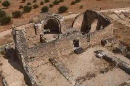
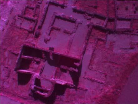
14 Status Update Small UAV Initiative Aibotix UAV Solutions
15 Mapping using small UAV Solution Aibotix Movie File 15
16 Comparison: Actual vs. Model 16


17 Product USPs and Added Values Professional Body Shielded propeller for collision protection and personal safety Automatic Take-off and Landing Automatic takeoff, landing and flight plan execution for 100% autonomous flights. Intuitive steering by tablet No need for complex piloting focus is entirely on application Future oriented HW/SW architecture Allows flexible adaptation of sensors and flight navigation components implemented In development Page 17


18 Some technical figures Main features: 40 km/h 12 m/s wind 5 kg total weight 2.5 kg payload Autopilot Up to 5 ha per flight Safety features: Shielded propellers Up to 2 mot. failsafe Emergency landing Coming home


19 Sensoric platform Platform Sensoric Thermocamera GPR Multispectral Odorsensors Promising Applications and Industry Solutions!


20 Fields of Application Application Customer/References Video x Inspection of power lines Industrial Inspection Bridge and facade inspections Inspection of photovoltaic systems Inspections in production plants Research project GIS Mapping/GIS- Applications Orthophoto, 3D-Models Virtual-Surveying


21 Rapid environmental mapping


22 Flight Area Zorita de los Canes - Spain Geo Referenced Satellite Image Base Map Flight Plan The Flight Plan was used three times for: 1. Multispectral Flight 2. Video Flight 3. Photo Flight for 3D Model


23 Collecting Ground Control Points - GCPs + + The Orthophoto is measured in with Ground GPS, which provides GCPs Ground Control Points. With those GCPs we geo - reference the Orthophoto and we enhance it with a GEO GRID. Note: Without Reference Image and without GCPs you cannot measure correctly and this is what you definetley need!


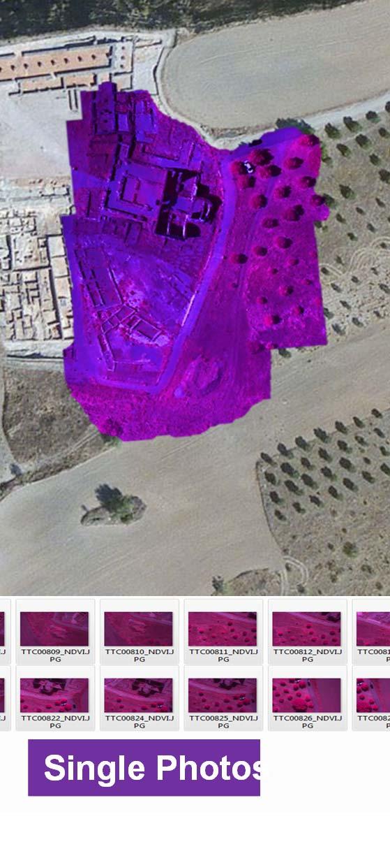
24 Flight Area Zorita de los Canes - Spain Multispectral NDVI Multispectral NIR Video Cut Out Single Photos
25 Mosaic Georeferenced Mosaic with Filter

26 Thank You! 04/07/10: EDIT OR DELETE THIS IN THE MASTER > SLIDE MASTER UNDER THE INSERT MENU.
Geo-localization and Mosaicing System (GEMS): Enabling Precision Image Feature Location and Rapid Mosaicing General:
: Enabling Precision Image Feature Location and Rapid Mosaicing General:") Geo-localization and Mosaicing System (GEMS): Enabling Precision Image Feature Location and Rapid Mosaicing General: info@senteksystems.com www.senteksystems.com 12/6/2014 Precision Agriculture Multi-Spectral
Geo-localization and Mosaicing System (GEMS): Enabling Precision Image Feature Location and Rapid Mosaicing General: info@senteksystems.com www.senteksystems.com 12/6/2014 Precision Agriculture Multi-Spectral
Leica - 3 rd Generation Airborne Digital Sensors Features / Benefits for Remote Sensing & Environmental Applications
 Leica - 3 rd Generation Airborne Digital Sensors Features / Benefits for Remote Sensing & Environmental Applications Arthur Rohrbach, Sensor Sales Dir Europe, Middle-East and Africa (EMEA) Luzern, Switzerland,
Phase One 190MP Aerial System
 White Paper Phase One 190MP Aerial System Introduction Phase One Industrial s 100MP medium format aerial camera systems have earned a worldwide reputation for its high performance. They are commonly used
EnsoMOSAIC Aerial mapping tools
 EnsoMOSAIC Aerial mapping tools Jakarta and Kuala Lumpur, 2013 Contents MosaicMill MM Application examples Software introduction System introduction Rikola HS sensor UAV platform examples SW Syst HS UAV
The drone for precision agriculture
 The drone for precision agriculture Reap the benefits of scouting crops from above If precision technology has driven the farming revolution of recent years, monitoring crops from the sky will drive the
Unmanned Aerial Vehicles: A New Approach for Coastal Habitat Assessment
 Unmanned Aerial Vehicles: A New Approach for Coastal Habitat Assessment David Ryan Principal Marine Scientist WorleyParsons Western Operations 2 OUTLINE Importance of benthic habitat assessment. Common
Monitoring the vegetation success of a rehabilitated mine site using multispectral UAV imagery. Tim Whiteside & Renée Bartolo, eriss
 Monitoring the vegetation success of a rehabilitated mine site using multispectral UAV imagery Tim Whiteside & Renée Bartolo, eriss About the Supervising Scientist Main roles Working to protect the environment
HIGH RESOLUTION COLOR IMAGERY FOR ORTHOMAPS AND REMOTE SENSING. Author: Peter Fricker Director Product Management Image Sensors
 HIGH RESOLUTION COLOR IMAGERY FOR ORTHOMAPS AND REMOTE SENSING Author: Peter Fricker Director Product Management Image Sensors Co-Author: Tauno Saks Product Manager Airborne Data Acquisition Leica Geosystems
MULTISPECTRAL AGRICULTURAL ASSESSMENT. Normalized Difference Vegetation Index. Federal Robotics INSPECTION & DOCUMENTATION
 MULTISPECTRAL AGRICULTURAL ASSESSMENT Normalized Difference Vegetation Index INSPECTION & DOCUMENTATION Federal Robotics Clearwater Dr. Amherst, New York 14228 716-221-4181 Sales@FedRobot.com www.fedrobot.com
The survey-grade mapping drone
 The survey-grade mapping drone 3 reasons to choose the ebee RTK 01. Survey-grade accuracy Absolute orthomosaic / Digital Elevation Model accuracy of down to 3 cm (1.2 in) without the need for GCPs meaning
LAST GENERATION UAV-BASED MULTI- SPECTRAL CAMERA FOR AGRICULTURAL DATA ACQUISITION
 LAST GENERATION UAV-BASED MULTI- SPECTRAL CAMERA FOR AGRICULTURAL DATA ACQUISITION FABIO REMONDINO, Erica Nocerino, Fabio Menna Fondazione Bruno Kessler Trento, Italy http://3dom.fbk.eu Marco Dubbini,
Leica ADS80 - Digital Airborne Imaging Solution NAIP, Salt Lake City 4 December 2008
 Luzern, Switzerland, acquired at 5 cm GSD, 2008. Leica ADS80 - Digital Airborne Imaging Solution NAIP, Salt Lake City 4 December 2008 Shawn Slade, Doug Flint and Ruedi Wagner Leica Geosystems AG, Airborne
Capture the invisible
 Capture the invisible A Capture the invisible The Sequoia multispectral sensor captures both visible and invisible images, providing calibrated data to optimally monitor the health and vigor of your crops.
Aerial Image Acquisition and Processing Services. Ron Coutts, M.Sc., P.Eng. RemTech, October 15, 2014
 Aerial Image Acquisition and Processing Services Ron Coutts, M.Sc., P.Eng. RemTech, October 15, 2014 Outline Applications & Benefits Image Sources Aircraft Platforms Image Products Sample Images & Comparisons
Jens Kremer ISPRS Hannover Workshop 2017,
 Jens Kremer ISPRS Hannover Workshop 2017, 8.06.2017 Modular aerial camera-systems The IGI UrbanMapper 2-in1 concept System Layout The DigiCAM-100 module The IGI UrbanMapper Sensor geometry & stitching
MULTIPURPOSE QUADCOPTER SOLUTION FOR AGRICULTURE
 MULTIPURPOSE QUADCOPTER SOLUTION FOR AGRICULTURE Powered by COVERS UP TO 30HA AT 70M FLIGHT ALTITUDE PER BATTERY PHOTO & VIDEO FULL HD 1080P - 14MP 3-AXIS STABILIZATION INCLUDES NDVI & ZONING MAPS SERVICE
Digital Aerial Photography UNBC March 22, Presented by: Dick Mynen TDB Consultants Inc.
 Digital Aerial Photography UNBC March 22, 2011 Presented by: Dick Mynen TDB Consultants Inc. Airborne Large Scale Digital Photography Who is using the technology in today s environment Options available
ScienceDirect. The potential of UAV-based remote sensing for supporting precision agriculture in Indonesia
 Available online at www.sciencedirect.com ScienceDirect Procedia Environmental Sciences 24 (2015 ) 245 253 The 1st International Symposium on LAPAN-IPB Satellite for Food Security and Environmental Monitoring
Five Sensors, One Day: Unmanned vs. Manned Logistics and Accuracy
 Five Sensors, One Day: Unmanned vs. Manned Logistics and Accuracy ASPRS UAS Mapping Technical Symposium Sept 13 th, 2016 Presenter: David Day, CP, GISP Keystone Aerial Surveys, Inc. Summary of activities
Ground Control Configuration Analysis for Small Area UAV Imagery Based Mapping
 Ground Control Configuration Analysis for Small Area UAV Imagery Based Mapping ASPRS IGTF 2017, Baltimore, MD March 15 th, 2017 Presenter: David Day, CP, GISP Wes Weaver Keystone Aerial Surveys, Inc. Summary
DISCO-PRO AG ALL-IN-ONE DRONE SOLUTION FOR PRECISION AGRICULTURE. 80ha COVERAGE PARROT SEQUOIA INCLUDES MULTI-PURPOSE TOOL SAFE ANALYZE & DECIDE
 DISCO-PRO AG ALL-IN-ONE DRONE SOLUTION FOR PRECISION AGRICULTURE Powered by 80ha COVERAGE AT 120M * FLIGHT ALTITUDE (200AC @ 400FT) MULTI-PURPOSE TOOL PHOTO 14MPX VIDEO 1080P FULL HD PARROT SEQUOIA RGB
PEGASUS : a future tool for providing near real-time high resolution data for disaster management. Lewyckyj Nicolas
 PEGASUS : a future tool for providing near real-time high resolution data for disaster management Lewyckyj Nicolas nicolas.lewyckyj@vito.be http://www.pegasus4europe.com Overview Vito in a nutshell GI
USE OF IMPROVISED REMOTELY SENSED DATA FROM UAV FOR GIS AND MAPPING, A CASE STUDY OF GOMA CITY, DR CONGO
 USE OF IMPROVISED REMOTELY SENSED DATA FROM UAV FOR GIS AND MAPPING, A CASE STUDY OF GOMA CITY, DR CONGO Cung Chin Thang United Nations Global Support Center, Brindisi, Italy, Email: thang@un.org KEY WORDS:
22/11/2013. UAV: Overview of systems, applications and processing Kris Nackaerts, Peter Strigencz
 22/11/2013 UAV: Overview of systems, applications and processing Kris Nackaerts, Peter Strigencz Introduction» Systems» Applications» Non-imaging» Imaging» Processing, focus on photogrammetry» Use case
DigitalGlobe High Resolution Satellite Imagery
 DigitalGlobe High Resolution Satellite Imagery KIAN KANG, SALES MANAGER, SOUTH EAST ASIA & TAIWAN See a better world. DigitalGlobe Overview Over 1,300 employees spanning the globe H E A D Q UA R T E R
Aerial efficiency, photogrammetric accuracy
 Aerial efficiency, photogrammetric accuracy Why sensefly 3 reasons to choose the ebee Plus Large coverage for optimal efficiency The ebee Plus can map more square kilometres per flight, than any drone
sensefly Camera Collection
 Camera Collection A professional sensor for every application Introducing S.O.D.A. 3D 3D mapping, redefined Image: S.O.D.A. 3D oblique image (left) merging into 3D mesh (right). Stunning digital 3D reconstructions
The brain for the plane is the Airelectronics' U-Pilot flight control system, which is embedded inside the plane's fuselage, leaving a lot of space on
 Airelectronics has developed a new complete solution meeting the needs of the farming science. The completely test Skywalkerplatform has been equipped with both thermal and multispectral cameras to measure
RPAS Photogrammetric Mapping Workflow and Accuracy
 RPAS Photogrammetric Mapping Workflow and Accuracy Dr Yincai Zhou & Dr Craig Roberts Surveying and Geospatial Engineering School of Civil and Environmental Engineering, UNSW Background RPAS category and
How Farmer Can Utilize Drone Mapping?
 Presented at the FIG Working Week 2017, May 29 - June 2, 2017 in Helsinki, Finland How Farmer Can Utilize Drone Mapping? National Land Survey of Finland Finnish Geospatial Research Institute Roope Näsi,
The survey-grade mapping drone
 The survey-grade mapping drone +380,000 +110,000 +19,000,000 FLIGHTS TO DATE FLIGHT HOURS HA COVERAGE 3 reasons to choose the ebee RTK Survey-grade accuracy Fully integrated workflow Compatible with existing
NAVIGATION AND REMOTE SENSING PAYLOADS AND METHODS OF THE SARVANT UNMANNED AERIAL SYSTEM
 NAVIGATION AND REMOTE SENSING PAYLOADS AND METHODS OF THE SARVANT UNMANNED AERIAL SYSTEM P. Molina, P. Fortuny, I. Colomina Institute of Geomatics -- Castelldefels (ES) M. Remy, K.A.C. Macedo, Y.R.C. Zúnigo,
ROLE OF SATELLITE DATA APPLICATION IN CADASTRAL MAP AND DIGITIZATION OF LAND RECORDS DR.T. RAVISANKAR GROUP HEAD (LRUMG) RSAA/NRSC/ISRO /DOS HYDERABAD
 RSAA/NRSC/ISRO /DOS HYDERABAD") ROLE OF SATELLITE DATA APPLICATION IN CADASTRAL MAP AND DIGITIZATION OF LAND RECORDS DR.T. RAVISANKAR GROUP HEAD (LRUMG) RSAA/NRSC/ISRO /DOS HYDERABAD WORKSHOP on Best Practices under National Land Records
ROLE OF SATELLITE DATA APPLICATION IN CADASTRAL MAP AND DIGITIZATION OF LAND RECORDS DR.T. RAVISANKAR GROUP HEAD (LRUMG) RSAA/NRSC/ISRO /DOS HYDERABAD WORKSHOP on Best Practices under National Land Records
Validation of the QuestUAV PPK System
 Validation of the QuestUAV PPK System 3cm in xy, 400ft, no GCPs, 100Ha, 25 flights Nigel King 1, Kerstin Traut 2, Cameron Weeks 3 & Ruairi Hardman 4 1 Director QuestUAV, 2 Data Analyst QuestUAV, 3 Production
Crop Scouting with Drones Identifying Crop Variability with UAVs
 DroneDeploy Crop Scouting with Drones Identifying Crop Variability with UAVs A Guide to Evaluating Plant Health and Detecting Crop Stress with Drone Data Table of Contents 01 Introduction Crop Scouting
While film cameras still
 aerial perspective by Mathias Lemmens, editor-in-chief, GIM International Digital Aerial Cameras System Configurations and Sensor Architectures Editor s note: This issue includes an extensive product survey
Intergeo 2017: Transition from Providing Solutions to Value Partnership
 ARTICLE Intergeo 2017: Transition from Providing Solutions to Value Partnership Intergeo 2017, the world s leading fair and conference on geodesy, geoinformation and land management, recently took place
MEDIUM FORMAT CAMERA EVALUATION BASED ON THE LATEST PHASE ONE TECHNOLOGY
 MEDIUM FORMAT CAMERA EVALUATION BASED ON THE LATEST PHASE ONE TECHNOLOGY T.Tölg a, G. Kemper b, D. Kalinski c a Phase One / Germany tto@phaseone.com b GGS GmbH, Speyer / Germany kemper@ggs-speyer.de c
EVALUATION OF PLEIADES-1A TRIPLET ON TRENTO TESTFIELD
 EVALUATION OF PLEIADES-1A TRIPLET ON TRENTO TESTFIELD D. Poli a, F. Remondino b, E. Angiuli c, G. Agugiaro b a Terra Messflug GmbH, Austria b 3D Optical Metrology Unit, Fondazione Bruno Kessler, Trento,
The Philippines SHARE Program in Aerial Imaging
 The Philippines SHARE Program in Aerial Imaging G. Tangonan, N. Libatique, C. Favila, J. Honrado, D. Solpico Ateneo Innovation Center This presentation is about our ongoing aerial imaging research in the
Baldwin and Mobile Counties, AL Orthoimagery Project Report. Submitted: March 23, 2016
 2015 Orthoimagery Project Report Submitted: Prepared by: Quantum Spatial, Inc 523 Wellington Way, Suite 375 Lexington, KY 40503 859-277-8700 Page i of iii Contents Project Report 1. Summary / Scope...
IGI Ltd. Serving the Aerial Survey Industry for more than 20 Years
 'Photogrammetric Week 05' Dieter Fritsch, Ed. Wichmann Verlag, Heidelberg 2005. Kremer 33 IGI Ltd. Serving the Aerial Survey Industry for more than 20 Years JENS KREMER, Kreuztal ABSTRACT Since 1982 IGI
The intelligent mapping & inspection drone
 The intelligent mapping & inspection drone 3 reasons to choose albris 1 flight, 3 types of imagery With the sensefly albris (previously called exom) you can switch between capturing high-res still, thermal
U-Pilot can fly the aircraft using waypoint navigation, even when the GPS signal has been lost by using dead-reckoning navigation. Can also orbit arou
 We offer a complete solution for a user that need to put a payload in a advanced position at low cost completely designed by the Spanish company Airelectronics. Using a standard computer, the user can
Some Notes on Using Balloon Photography For Modeling the Landslide Area
 Some Notes on Using Balloon Photography For Modeling the Landslide Area Catur Aries Rokhmana Department of Geodetic-Geomatics Engineering Gadjah Mada University Grafika No.2 Yogyakarta 55281 - Indonesia
Overview. Objectives. The ultimate goal is to compare the performance that different equipment offers us in a photogrammetric flight.
 Overview At present, one of the most commonly used technique for topographic surveys is aerial photogrammetry. This technique uses aerial images to determine the geometric properties of objects and spatial
REMOTE SENSING WITH DRONES. YNCenter Video Conference Chang Cao
 REMOTE SENSING WITH DRONES YNCenter Video Conference Chang Cao 08-28-2015 28 August 2015 2 Drone remote sensing It was first utilized in military context and has been given great attention in civil use
NEW. Airborne Laser Scanning. Dual Wavelength Waveform Processing Airborne LiDAR Scanning System for High-Point Density Mapping Applications
 Dual Wavelength Waveform Processing Airborne LiDAR Scanning System for High-Point Density Mapping Applications NEW RIEGL VQ-156i-DW enhanced target characterization based upon simultaneous measurements
Drones for Telecommunications
 April 6, 2017 Drones for Telecommunications How AT&T uses drones to support and enhance its network Art Pregler AT&T UAS Program Director 2017 AT&T Intellectual Property. All rights reserved. AT&T, Globe
Lecture 7. Leica ADS 80 Camera System and Imagery. Ontario ADS 80 FRI Imagery. NRMT 2270, Photogrammetry/Remote Sensing
 NRMT 2270, Photogrammetry/Remote Sensing Lecture 7 Leica ADS 80 Camera System and Imagery. Ontario ADS 80 FRI Imagery. Tomislav Sapic GIS Technologist Faculty of Natural Resources Management Lakehead University
Update on UltraCam and UltraMap technology
 Update on UltraCam and UltraMap technology Alexander Wiechert, Michael Gruber Anzengrubergasse 8/4, 8010 Graz, Austria {alexander.wiechert, michael.gruber}@vexcel-imaging.com Stuttgart, September 2017
VisionMap Sensors and Processing Roadmap
 Vilan, Gozes 51 VisionMap Sensors and Processing Roadmap YARON VILAN, ADI GOZES, Tel-Aviv ABSTRACT The A3 is a family of digital aerial mapping cameras and photogrammetric processing systems, which is
Introduction to Remote Sensing Lab 6 Dr. Hurtado Wed., Nov. 28, 2018
 Lab 6: UAS Remote Sensing Due Wed., Dec. 5, 2018 Goals 1. To learn about the operation of a small UAS (unmanned aerial system), including flight characteristics, mission planning, and FAA regulations.
Visual inspection strategies for large bridges using Unmanned Aerial Vehicles (UAV)
") Visual inspection strategies for large bridges using Unmanned Aerial Vehicles (UAV) Norman Hallermann & Guido Morgenthal Bauhaus-Universität Weimar, Chair of Modeling and Simulation of Structures, Weimar,
Visual inspection strategies for large bridges using Unmanned Aerial Vehicles (UAV) Norman Hallermann & Guido Morgenthal Bauhaus-Universität Weimar, Chair of Modeling and Simulation of Structures, Weimar,
Heterogeneous Control of Small Size Unmanned Aerial Vehicles
 Magyar Kutatók 10. Nemzetközi Szimpóziuma 10 th International Symposium of Hungarian Researchers on Computational Intelligence and Informatics Heterogeneous Control of Small Size Unmanned Aerial Vehicles
Flood modelling and management. Glasgow University. 8 September Paul Shaw - GeoVision
 Flood modelling and management Glasgow University 8 September 2004 Paul Shaw - GeoVision How important are heights in flood modelling? Comparison of data collection technologies GPS - Global Positioning
An NDVI image provides critical crop information that is not visible in an RGB or NIR image of the same scene. For example, plants may appear green
 Normalized Difference Vegetation Index (NDVI) Spectral Band calculation that uses the visible (RGB) and near-infrared (NIR) bands of the electromagnetic spectrum NDVI= + An NDVI image provides critical
The Hyperspectral UAV (HyUAV) a novel UAV-based spectroscopy tool for environmental monitoring
 a novel UAV-based spectroscopy tool for environmental monitoring") The Hyperspectral UAV (HyUAV) a novel UAV-based spectroscopy tool for environmental monitoring R. Garzonio 1, S. Cogliati 1, B. Di Mauro 1, A. Zanin 2, B. Tattarletti 2, F. Zacchello 2, P. Marras 2 and
The Hyperspectral UAV (HyUAV) a novel UAV-based spectroscopy tool for environmental monitoring R. Garzonio 1, S. Cogliati 1, B. Di Mauro 1, A. Zanin 2, B. Tattarletti 2, F. Zacchello 2, P. Marras 2 and
Abstract Quickbird Vs Aerial photos in identifying man-made objects
 Abstract Quickbird Vs Aerial s in identifying man-made objects Abdullah Mah abdullah.mah@aramco.com Remote Sensing Group, emap Division Integrated Solutions Services Department (ISSD) Saudi Aramco, Dhahran
Module 3 Introduction to GIS. Lecture 8 GIS data acquisition
 Module 3 Introduction to GIS Lecture 8 GIS data acquisition GIS workflow Data acquisition (geospatial data input) GPS Remote sensing (satellites, UAV s) LiDAR Digitized maps Attribute Data Management Data
Assessment of Unmanned Aerial Vehicle for Management of Disaster Information
 Journal of the Korea Academia-Industrial cooperation Society Vol. 16, No. 1 pp. 697-702, 2015 http://dx.doi.org/10.5762/kais.2015.16.1.697 ISSN 1975-4701 / eissn 2288-4688 Assessment of Unmanned Aerial
Hardware Modeling and Machining for UAV- Based Wideband Radar
 Hardware Modeling and Machining for UAV- Based Wideband Radar By Ryan Tubbs Abstract The Center for Remote Sensing of Ice Sheets (CReSIS) at the University of Kansas is currently implementing wideband
MSB Imagery Program FAQ v1
 MSB Imagery Program FAQ v1 (F)requently (A)sked (Q)uestions 9/22/2016 This document is intended to answer commonly asked questions related to the MSB Recurring Aerial Imagery Program. Table of Contents
Earth Observation at Spin.Works
 Earth Observation at Spin.Works H2020 Space Information Day Lisboa September 29, 2016 Spin.Works, S.A. Av. Da Igreja nº42 6º 1700-239 Lisboa Phone/Fax +351 21 012 8452 info@spinworks.pt www.spinworks.pt
Phase One ixu-rs1000 Accuracy Assessment Report Yu. Raizman, PhaseOne.Industrial, Israel
 17 th International Scientific and Technical Conference FROM IMAGERY TO DIGITAL REALITY: ERS & Photogrammetry Phase One ixu-rs1000 Accuracy Assessment Report Yu. Raizman, PhaseOne.Industrial, Israel 1.
Classical Control Based Autopilot Design Using PC/104
 Classical Control Based Autopilot Design Using PC/104 Mohammed A. Elsadig, Alneelain University, Dr. Mohammed A. Hussien, Alneelain University. Abstract Many recent papers have been written in unmanned
AG-VA Fully Autonomous UAV Sprayers
 AG-VA Fully Autonomous UAV Sprayers One of the most advance sprayer technology on the market! Best Price - Best Flight Time - Best Coverage Rate - 1 Yr Warranty* The AG-VA UAV Sprayer is available in 3
BIOMEDICAL ELECTRONICS. Date & Day II - SEMESTER ADVANCED MEDICAL IMAGING DIAGNOSTIC AND THERAPEUTIC EQUIPMENT MEDICAL PRODUCT DESIGN
 OSMANIA UNIVERSITY, HYDERABAD - 7 M. E. (BME) (Main) Examination, September 2013 EXAMINATION TIME TABLE Time : 2.00 PM to 5.00 PM Department of BME Date & Day BIOMEDICAL ELECTRONICS II - SEMESTER ADVANCED
Photomod Lite Contest 2013 Creating vegetation map using UAV at Seaside Palouki forest (Greece) by Apostolos Nteris
 by Apostolos Nteris") P r o j e c t I n f o r m a t i o n Title: Creating vegetation map using UAV at seaside Palouki forest (Greece) Author: Apostolos Nteris, Surveyor engineer OLYZON consulting - Trikala Greece Contact: Apostolos
P r o j e c t I n f o r m a t i o n Title: Creating vegetation map using UAV at seaside Palouki forest (Greece) Author: Apostolos Nteris, Surveyor engineer OLYZON consulting - Trikala Greece Contact: Apostolos
2/9/2018. Fun with Drones Raymond J. Hintz, PLS, PhD University of Maine
 Fun with Drones Raymond J. Hintz, PLS, PhD University of Maine Raymond.hintz@umit.maine.edu 2 types (1)Fixed wing (airplane) -can be cheaper -can be faster and last longer on a battery -Need a take-off
Fun with Drones Raymond J. Hintz, PLS, PhD University of Maine
 Fun with Drones Raymond J. Hintz, PLS, PhD University of Maine Raymond.hintz@umit.maine.edu 2 types (1)Fixed wing (airplane) -can be cheaper -can be faster and last longer on a battery -Need a take-off
The intelligent mapping & inspection drone
 The intelligent mapping & inspection drone 3 reasons to choose albris 1 flight, 3 types of imagery With the sensefly albris you can switch between capturing highres still, thermal and video imagery during
VisionMap A3 Edge A Single Camera for Multiple Solutions
 Photogrammetric Week '15 Dieter Fritsch (Ed.) Wichmann/VDE Verlag, Belin & Offenbach, 2015 Raizman, Gozes 57 VisionMap A3 Edge A Single Camera for Multiple Solutions Yuri Raizman, Adi Gozes, Tel-Aviv ABSTRACT
NovAtel SPAN and Waypoint. GNSS + INS Technology
 NovAtel SPAN and Waypoint GNSS + INS Technology SPAN Technology SPAN provides continual 3D positioning, velocity and attitude determination anywhere satellite reception may be compromised. SPAN uses NovAtel
UAS Photogrammetry Best Practices
 UAS Photogrammetry Best Practices Pennsylvania Society of Land Surveyors January 15, 2019 Bryan Baker Certified Mapping Scientist (UAS) Bryan Baker UAS Sales Manager Leica Geosystems Reality Capture Team
Unmanned Aerial Vehicle Data Acquisition for Damage Assessment in. Hurricane Events
 Unmanned Aerial Vehicle Data Acquisition for Damage Assessment in Hurricane Events Stuart M. Adams a Carol J. Friedland b and Marc L. Levitan c ABSTRACT This paper examines techniques for data collection
CHARLES MONDELLO PAST PRESIDENT PDC ASPRS FELLOW
 SMALL UNMANNED AERIAL SYSTEMS (SUAS) IN EMERGENCY MANAGEMENT RANDY FRANK MARION COUNTY DIRECTOR EMERGENCY MANAGEMENT CHARLES MONDELLO PAST PRESIDENT PDC ASPRS FELLOW SUAS OR DRONE OR UAV 1) Small Unmanned
Remote Sensing Platforms
 Types of Platforms Lighter-than-air Remote Sensing Platforms Free floating balloons Restricted by atmospheric conditions Used to acquire meteorological/atmospheric data Blimps/dirigibles Major role - news
HALS-H1 Ground Surveillance & Targeting Helicopter
 ARATOS-SWISS Homeland Security AG & SMA PROGRESS, LLC HALS-H1 Ground Surveillance & Targeting Helicopter Defense, Emergency, Homeland Security (Border Patrol, Pipeline Monitoring)... Automatic detection
Vexcel Imaging GmbH Innovating in Photogrammetry: UltraCamXp, UltraCamLp and UltraMap
 Photogrammetric Week '09 Dieter Fritsch (Ed.) Wichmann Verlag, Heidelberg, 2009 Wiechert, Gruber 27 Vexcel Imaging GmbH Innovating in Photogrammetry: UltraCamXp, UltraCamLp and UltraMap ALEXANDER WIECHERT,
IGI mbh - 40 years celebration
 ntegrated eospatial nnovations IGI mbh - 40 years celebration Founded 1978 More than 500 customers in 84 different countries World-wide technical support IGI office in Kreuztal, Germany 3 Open Skies Area
Scaling Up Drone Science for Agriculture & Nature Resources through Cooperative Extension
 Scaling Up Drone Science for Agriculture & Nature Resources through Cooperative Extension Andy Lyons, Maggi Kelly, Sean Hogan, Shane Feirer, Robert Johnson CalGIS 2017, Oakland, CA. May 23, 2017 How and
2017 TSPS Annual Conference & Tech Expo Unmanned Aircraft Systems (UAS) As a Tool for Land Surveyors
 As a Tool for Land Surveyors") 2017 TSPS Annual Conference & Tech Expo Unmanned Aircraft Systems (UAS) As a Tool for Land Surveyors George Southard GSKS Associates LLC Introduction George Southard: Master s Degree in Photogrammetry
2017 TSPS Annual Conference & Tech Expo Unmanned Aircraft Systems (UAS) As a Tool for Land Surveyors George Southard GSKS Associates LLC Introduction George Southard: Master s Degree in Photogrammetry
E m e r g e n c y M a n a g e m e n t S e r v i c e. C o p e r n i c u s A e r i a l c o m p o n e n t s t a t u s s t u d y
 E m e r g e n c y M a n a g e m e n t S e r v i c e C o p e r n i c u s A e r i a l c o m p o n e n t s t a t u s s t u d y Peter Spruyt European Commission Joint Research Centre EMS Mapping User Workshop
Managing Imagery and Raster Data. Peter Becker
 Managing Imagery and Raster Data Peter Becker ArcGIS is a Comprehensive Imagery Platform Empowering you to make informed decisions System of Engagement System of Insight Extract Information from Imagery
Vegetation Indexing made easier!
 Remote Sensing Vegetation Indexing made easier! TETRACAM MCA & ADC Multispectral Camera Systems TETRACAM MCA and ADC are multispectral cameras for critical narrow band digital photography. Based on the
Processing of stereo scanner: from stereo plotter to pixel factory
 Photogrammetric Week '03 Dieter Fritsch (Ed.) Wichmann Verlag, Heidelberg, 2003 Bignone 141 Processing of stereo scanner: from stereo plotter to pixel factory FRANK BIGNONE, ISTAR, France ABSTRACT With
Airborne hyperspectral data over Chikusei
 SPACE APPLICATION LABORATORY, THE UNIVERSITY OF TOKYO Airborne hyperspectral data over Chikusei Naoto Yokoya and Akira Iwasaki E-mail: {yokoya, aiwasaki}@sal.rcast.u-tokyo.ac.jp May 27, 2016 ABSTRACT Airborne
High throughput phenotyping of field crop experiments using UAVs. Ph. Burger, R. Marandel, F. Baret, G. Colombeau, A. Comar
 High throughput phenotyping of field crop experiments using UAVs Ph. Burger, R. Marandel, F. Baret, G. Colombeau, A. Comar PHILIPPE BURGER Drone Garden Workshop - 10/07/2018 Phenotyping? Genotype= the
Introduction to KOMPSAT
 Introduction to KOMPSAT September, 2016 1 CONTENTS 01 Introduction of SIIS 02 KOMPSAT Constellation 03 New : KOMPSAT-3 50 cm 04 New : KOMPSAT-3A 2 KOMPSAT Constellation KOMPSAT series National space program
Application of Satellite Remote Sensing for Natural Disasters Observation
 Application of Satellite Remote Sensing for Natural Disasters Observation Prof. Krištof Oštir, Ph.D. University of Ljubljana Faculty of Civil and Geodetic Engineering Outline Earth observation current
Leica RCD30 Calibration Certificate
 Leica RCD30 Calibration Certificate Camera Head Serial Number Lens Serial Number This certificate is valid for CH62 62001 NAG-D 3.5/50 50002 Inspector Calibration certificate issued on 23 June 2011 Udo
LECTURE NOTES 2016 CONTENTS. Sensors and Platforms for Acquisition of Aerial and Satellite Image Data
 LECTURE NOTES 2016 Prof. John TRINDER School of Civil and Environmental Engineering Telephone: (02) 9 385 5020 Fax: (02) 9 313 7493 j.trinder@unsw.edu.au CONTENTS Chapter 1 Chapter 2 Sensors and Platforms
The EDA SUM Project. Surveillance in an Urban environment using Mobile sensors. 2012, September 13 th - FMV SENSORS SYMPOSIUM 2012
 Surveillance in an Urban environment using Mobile sensors 2012, September 13 th - FMV SENSORS SYMPOSIUM 2012 TABLE OF CONTENTS European Defence Agency Supported Project 1. SUM Project Description. 2. Subsystems
FLCS V2.1. AHRS, Autopilot, Gyro Stabilized Gimbals Control, Ground Control Station
 AHRS, Autopilot, Gyro Stabilized Gimbals Control, Ground Control Station The platform provides a high performance basis for electromechanical system control. Originally designed for autonomous aerial vehicle
GIS in Water Resources CEE 6440
 GIS in Water Resources CEE 6440 Optimal representation of plants & soils characteristics using high resolution imagery" Prepared by Manal ELarab Fall 202 Outline. Introduction: Precision Agriculture...
NovAtel SPAN and Waypoint GNSS + INS Technology
 NovAtel SPAN and Waypoint GNSS + INS Technology SPAN Technology SPAN provides real-time positioning and attitude determination where traditional GNSS receivers have difficulties; in urban canyons or heavily
Geospatial Vision and Policies Korean Industry View 26 November, 2014 SI Imaging Services
 Geospatial Vision and Policies Korean Industry View 26 November, 2014 SI Imaging Services Distribution Limitation, SI Imaging Services Proprietary Data : The data contained in this document, without the
Helicopter Aerial Laser Ranging
 Helicopter Aerial Laser Ranging Håkan Sterner TopEye AB P.O.Box 1017, SE-551 11 Jönköping, Sweden 1 Introduction Measuring distances with light has been used for terrestrial surveys since the fifties.
TESTFIELD TRENTO: GEOMETRIC EVALUATION OF VERY HIGH RESOLUTION SATELLITE IMAGERY
 TESTFIELD TRENTO: GEOMETRIC EVALUATION OF VERY HIGH RESOLUTION SATELLITE IMAGERY G. AGUGIAROa, D. POLIb, F. REMONDINOa, 3DOM, 3D Optical Metrology Unit Bruno Kessler Foundation, Trento, Italy a b Vermessung