Aerial efficiency, photogrammetric accuracy
|
|
|
- Everett Fox
- 5 years ago
- Views:
Transcription
1 Aerial efficiency, photogrammetric accuracy


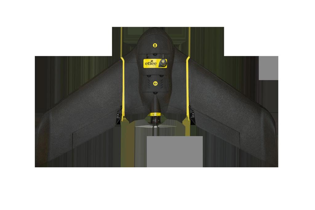
2 Why sensefly 3 reasons to choose the ebee Plus Large coverage for optimal efficiency The ebee Plus can map more square kilometres per flight, than any drone in its weight class, allowing you to maximise your efficiency and plan projects with confidence. High Precision on Demand (HPoD) The ebee Plus includes built-in RTK/PPK functionality that can be activated either out of the box or later when required. It s survey-grade accuracy you control, without the need for ground control points for less time in the field and more time putting your data to work. Project-perfect payloads The ebee Plus offers a camera to suit every application, including the sensefly S.O.D.A. (supplied), the first camera designed for photogrammetric drone mapping. Intelligent integration sensefly drones are ready to fly out of the box. Lightweight, safe & durable, these fully-integrated systems are powered by a single battery and managed by our aviation-quality autopilot. Quality global support sensefly drones include free software updates & efficient online support linked to local expert repair centres. Further maintenance packages & extended warranty options are also available. +380, , ,000,000 Education included sensefly s sales staff are experts in their fields, plus sensefly customers gain free access to a wealth of educational materials, including a full online Knowledge Base, tutorials, webinars & more. emotion excellence sensefly s emotion is the most advanced flight planning & control software around. Built with safety in mind, it makes planning, simulation & monitoring automatic drone flights simple. FLIGHTS TO DATE FLIGHT HOURS HA COVERAGE


 maximum coverage Includes emotion 3! emotion 3 is sensefly s next-generation drone flight & data management software.")
3 Project-perfect payloads The ebee Plus in a uniquely flexible tool. It is available with multiple camera payloads, so you need only invest in the configuration that suits your business needs. Large coverage for optimal efficiency > A sensor for every application: Professional-grade RGB: surveying/geospatial Thermal infrared: photovoltaic/rescue/environmental Multispectral: agriculture/forestry/conservation > Supplied with sensefly S.O.D.A. (Sensor Optimised for Drone Applications) > Backwards-compatible with existing ebee sensors * (upgrade to ebee Plus to extend ground coverage while minimising your sensor costs) The lightweight, hand-launched ebee Plus is a seriously efficient data collection tool. Its flight time of 59 minutes is a figure you can rely on: whichever camera you fly, at virtually any altitude, and in varying wind conditions. The result is less time spent flight planning and swapping batteries, and more time collecting exactly the geospatial data you need. > Confirmed real-world flight time: 59 minutes > Capable of mapping more, per flight, than any drone in its weight class: Up to 220 ha (540 ac) in a single 122 m (400 ft) flight Up to 40 km 2 (15.4 mi 2 ) maximum coverage Includes emotion 3! emotion 3 is sensefly s next-generation drone flight & data management software. It includes: mission block flight planning, efficient multi-flight missions, a full 3D control environment, multiple payload support, cloud connectivity & more sensefly S.O.D.A. Sensor Optimised for Drone Applications The sensefly S.O.D.A. is the first camera to be designed for professional drone photogrammetry. It captures amazingly sharp aerial RGB images, across a range of light conditions, allowing you to produce detailed, vivid orthomosaics and highly precise digital surface models. * select cameras may only support RTK standalone mode


 PPK (Raw dual-frequency logging) No base station or VRS (with GCPs) VRS Virtual Reference Station (real-time) Base station Known position (e.g. CORS) Unknown position (real-time) Orthomosaic overlaid on DSM.")
4 High Precision on Demand (HPoD) The ebee Plus features High Precision on Demand (HPoD) thanks to its built-in RTK/ PPK functionality. You can activate this whenever it suits your business right out of the box, or later. It s survey-grade accuracy you control, without the need for ground control points for less time in the field and more time putting your data to work. On-demand survey-grade outputs without ground control points Absolute orthomosaic & digital surface model accuracy of down to 3 cm (1.2 in) Achievable across virtually every site Employ your existing reference station & GNSS knowledge Achievable absolute accuracy Standalone mode (RTK/PPK not activated) RTK (RTCM 2/3 corrections) PPK (Raw dual-frequency logging) No base station or VRS (with GCPs) VRS Virtual Reference Station (real-time) Base station Known position (e.g. CORS) Unknown position (real-time) Orthomosaic overlaid on DSM. GSD: 3 cm (1.2 in)/pixel. Coverage: 72 ha (178 ac). Flight height: 122 m (400 ft) AGL. RTK to PPK fallback always available 1 down to 3 cm (1.2 in) horizontal / 5 cm (2 in) vertical
 Detachable wings Yes Sensor (supplied2) sensefly S.O.D.A.")
5 Technical specifications HARDWARE Wingspan 110 cm (43.3 in) Weight 1.1 kg (2.4 lb) Motor Low-noise, brushless, electric Radio link range 3 km nominal (up to1 8 km) / 1.86 mi (up to mi) Detachable wings Yes Sensor (supplied2) sensefly S.O.D.A. Sensors (optional) Parrot Sequoia, thermomap Accessories (optional) Radio tracker, backpack, camera protection kit SOFTWARE Flight planning & control software (supplied) emotion 3 Image processing software (optional) Pix4Dmapper OPERATION Automatic 3D flight planning Yes Cruise speed km/h (11-30 m/s or mph) Wind resistance Up to 45 km/h (12 m/s or 28 mph) Maximum flight time 59 minutes Automatic landing Linear landing with ~ 5 m (16 ft) accuracy Ground control points (GCPs) required No (RTK/PPK activated), optional (RTK/PPK unactivated) Hand launch (no catapult required) Yes RESULTS Nominal coverage at 120 m (400 ft) 220 ha (540 ac) 3 Maximum coverage4 40 km2 (15.4 mi2) Ground Sampling Distance Down to 1 cm (0.4 in) / pixel Absolute X, Y, Z accuracy (RTK/PPK activated or w/gcps) Down to 3 cm (1.2 in) / 5 cm (2 in) Absolute X, Y, Z accuracy (no RTK/PPK, no GCPs) 1-5 m (3-16 ft) sensefly S.O.D.A. Sensor type RGB (20 megapixel) Sensor size 1-inch (optical format) Pixel pitch 2.33 μm Shutter Global Ground resolution (at 122 m/400 ft AGL) 2.9 cm/px (1.1 in/px) Dust & shock protection Yes in ideal conditions optional in Turkey flight height above ground level; results excl. reconstructible zone around planned area 4 based on 2,500 m (8,202 ft) flight altitude above ground level; results incl. reconstructible zone around planned area 1 2 3
The survey-grade mapping drone
 The survey-grade mapping drone 3 reasons to choose the ebee RTK 01. Survey-grade accuracy Absolute orthomosaic / Digital Elevation Model accuracy of down to 3 cm (1.2 in) without the need for GCPs meaning
The drone for precision agriculture
 The drone for precision agriculture Reap the benefits of scouting crops from above If precision technology has driven the farming revolution of recent years, monitoring crops from the sky will drive the
The survey-grade mapping drone
 The survey-grade mapping drone +380,000 +110,000 +19,000,000 FLIGHTS TO DATE FLIGHT HOURS HA COVERAGE 3 reasons to choose the ebee RTK Survey-grade accuracy Fully integrated workflow Compatible with existing
White Paper Reaching 1 cm (0.4 in) drone survey accuracy
 drone survey accuracy") White Paper Reaching 1 cm (0.4 in) drone survey accuracy 3x higher absolute accuracy with WingtraOne Latest tests in USA and Switzerland prove that the VTOL WingtraOne drone repeatably reaches the best-in-class
White Paper Reaching 1 cm (0.4 in) drone survey accuracy 3x higher absolute accuracy with WingtraOne Latest tests in USA and Switzerland prove that the VTOL WingtraOne drone repeatably reaches the best-in-class
White Paper Reaching 1 cm (0.4 in) drone survey accuracy
 drone survey accuracy") White Paper Reaching 1 cm (0.4 in) drone survey accuracy 3x higher absolute accuracy with WingtraOne Latest tests in the USA and Switzerland prove that the VTOL WingtraOne drone repeatedly reaches the
White Paper Reaching 1 cm (0.4 in) drone survey accuracy 3x higher absolute accuracy with WingtraOne Latest tests in the USA and Switzerland prove that the VTOL WingtraOne drone repeatedly reaches the
White Paper Reaching 1 cm (0.4 in) drone survey accuracy
 drone survey accuracy") White Paper Reaching 1 cm (0.4 in) drone survey accuracy 3x higher absolute accuracy with WingtraOne Latest tests in USA and Switzerland prove that the VTOL WingtraOne drone repeatably reaches the best-in-class
White Paper Reaching 1 cm (0.4 in) drone survey accuracy 3x higher absolute accuracy with WingtraOne Latest tests in USA and Switzerland prove that the VTOL WingtraOne drone repeatably reaches the best-in-class
sensefly Camera Collection
 Camera Collection A professional sensor for every application Introducing S.O.D.A. 3D 3D mapping, redefined Image: S.O.D.A. 3D oblique image (left) merging into 3D mesh (right). Stunning digital 3D reconstructions
The intelligent mapping & inspection drone
 The intelligent mapping & inspection drone 3 reasons to choose albris 1 flight, 3 types of imagery With the sensefly albris you can switch between capturing highres still, thermal and video imagery during
Validation of the QuestUAV PPK System
 Validation of the QuestUAV PPK System 3cm in xy, 400ft, no GCPs, 100Ha, 25 flights Nigel King 1, Kerstin Traut 2, Cameron Weeks 3 & Ruairi Hardman 4 1 Director QuestUAV, 2 Data Analyst QuestUAV, 3 Production
The intelligent mapping & inspection drone
 The intelligent mapping & inspection drone 3 reasons to choose albris 1 flight, 3 types of imagery With the sensefly albris (previously called exom) you can switch between capturing high-res still, thermal
RPAS Photogrammetric Mapping Workflow and Accuracy
 RPAS Photogrammetric Mapping Workflow and Accuracy Dr Yincai Zhou & Dr Craig Roberts Surveying and Geospatial Engineering School of Civil and Environmental Engineering, UNSW Background RPAS category and
DISCO-PRO AG ALL-IN-ONE DRONE SOLUTION FOR PRECISION AGRICULTURE. 80ha COVERAGE PARROT SEQUOIA INCLUDES MULTI-PURPOSE TOOL SAFE ANALYZE & DECIDE
 DISCO-PRO AG ALL-IN-ONE DRONE SOLUTION FOR PRECISION AGRICULTURE Powered by 80ha COVERAGE AT 120M * FLIGHT ALTITUDE (200AC @ 400FT) MULTI-PURPOSE TOOL PHOTO 14MPX VIDEO 1080P FULL HD PARROT SEQUOIA RGB
UAV PHOTOGRAMMETRY COMPARED TO TRADITIONAL RTK GPS SURVEYING
 UAV PHOTOGRAMMETRY COMPARED TO TRADITIONAL RTK GPS SURVEYING Brad C. Mathison and Amber Warlick March 20, 2016 Fearless Eye Inc. Kansas City, Missouri www.fearlesseye.com KEY WORDS: UAV, UAS, Accuracy
MULTIPURPOSE QUADCOPTER SOLUTION FOR AGRICULTURE
 MULTIPURPOSE QUADCOPTER SOLUTION FOR AGRICULTURE Powered by COVERS UP TO 30HA AT 70M FLIGHT ALTITUDE PER BATTERY PHOTO & VIDEO FULL HD 1080P - 14MP 3-AXIS STABILIZATION INCLUDES NDVI & ZONING MAPS SERVICE
Capture the invisible
 Capture the invisible A Capture the invisible The Sequoia multispectral sensor captures both visible and invisible images, providing calibrated data to optimally monitor the health and vigor of your crops.
Overview. Objectives. The ultimate goal is to compare the performance that different equipment offers us in a photogrammetric flight.
 Overview At present, one of the most commonly used technique for topographic surveys is aerial photogrammetry. This technique uses aerial images to determine the geometric properties of objects and spatial
Deliverable 5-B: Review and Update on AURA System Requirements, Sensors, and Platforms Supplemental Report
 Deliverable 5-B: Review and Update on AURA System Requirements, Sensors, and Platforms Supplemental Report Focusing on education, research, and development of technology to sense and understand natural
Five Sensors, One Day: Unmanned vs. Manned Logistics and Accuracy
 Five Sensors, One Day: Unmanned vs. Manned Logistics and Accuracy ASPRS UAS Mapping Technical Symposium Sept 13 th, 2016 Presenter: David Day, CP, GISP Keystone Aerial Surveys, Inc. Summary of activities
Introduction to Photogrammetry
 Introduction to Photogrammetry Presented By: Sasanka Madawalagama Geoinformatics Center Asian Institute of Technology Thailand www.geoinfo.ait.asia Content Introduction to photogrammetry 2D to 3D Drones
Phase One 190MP Aerial System
 White Paper Phase One 190MP Aerial System Introduction Phase One Industrial s 100MP medium format aerial camera systems have earned a worldwide reputation for its high performance. They are commonly used
Geo-localization and Mosaicing System (GEMS): Enabling Precision Image Feature Location and Rapid Mosaicing General:
: Enabling Precision Image Feature Location and Rapid Mosaicing General:") Geo-localization and Mosaicing System (GEMS): Enabling Precision Image Feature Location and Rapid Mosaicing General: info@senteksystems.com www.senteksystems.com 12/6/2014 Precision Agriculture Multi-Spectral
Geo-localization and Mosaicing System (GEMS): Enabling Precision Image Feature Location and Rapid Mosaicing General: info@senteksystems.com www.senteksystems.com 12/6/2014 Precision Agriculture Multi-Spectral
AG-VA Fully Autonomous UAV Sprayers
 AG-VA Fully Autonomous UAV Sprayers One of the most advance sprayer technology on the market! Best Price - Best Flight Time - Best Coverage Rate - 1 Yr Warranty* The AG-VA UAV Sprayer is available in 3
Monitoring the vegetation success of a rehabilitated mine site using multispectral UAV imagery. Tim Whiteside & Renée Bartolo, eriss
 Monitoring the vegetation success of a rehabilitated mine site using multispectral UAV imagery Tim Whiteside & Renée Bartolo, eriss About the Supervising Scientist Main roles Working to protect the environment
EnsoMOSAIC Aerial mapping tools
 EnsoMOSAIC Aerial mapping tools Jakarta and Kuala Lumpur, 2013 Contents MosaicMill MM Application examples Software introduction System introduction Rikola HS sensor UAV platform examples SW Syst HS UAV
ACCURACY ASSESSMENT OF DIRECT GEOREFERENCING FOR PHOTOGRAMMETRIC APPLICATIONS ON SMALL UNMANNED AERIAL PLATFORMS
 ACCURACY ASSESSMENT OF DIRECT GEOREFERENCING FOR PHOTOGRAMMETRIC APPLICATIONS ON SMALL UNMANNED AERIAL PLATFORMS O. Mian a, J. Lutes a, G. Lipa a, J. J. Hutton a, E. Gavelle b S. Borghini c * a Applanix
Experimental aerial photogrammetry with professional non metric camera Canon EOS 5D
 Experimental aerial photogrammetry with professional non metric camera Canon EOS 5D Ante Sladojević, Goran Mrvoš Galileo Geo Sustavi, Croatia 1. Introduction With this project we wanted to test professional
AIRPORT MAPPING JUNE 2016 EXPLORING UAS EFFECTIVENESS GEOSPATIAL SLAM TECHNOLOGY FEMA S ROMANCE WITH LIDAR VOLUME 6 ISSUE 4
 VOLUME 6 ISSUE 4 JUNE 2016 AIRPORT MAPPING 18 EXPLORING UAS EFFECTIVENESS 29 GEOSPATIAL SLAM TECHNOLOGY 36 FEMA S ROMANCE WITH LIDAR Nearly 2,000 U.S. landfill facilities stand to gain from cost-effective
VisionMap Sensors and Processing Roadmap
 Vilan, Gozes 51 VisionMap Sensors and Processing Roadmap YARON VILAN, ADI GOZES, Tel-Aviv ABSTRACT The A3 is a family of digital aerial mapping cameras and photogrammetric processing systems, which is
Aerial Image Acquisition and Processing Services. Ron Coutts, M.Sc., P.Eng. RemTech, October 15, 2014
 Aerial Image Acquisition and Processing Services Ron Coutts, M.Sc., P.Eng. RemTech, October 15, 2014 Outline Applications & Benefits Image Sources Aircraft Platforms Image Products Sample Images & Comparisons
Ground Control Configuration Analysis for Small Area UAV Imagery Based Mapping
 Ground Control Configuration Analysis for Small Area UAV Imagery Based Mapping ASPRS IGTF 2017, Baltimore, MD March 15 th, 2017 Presenter: David Day, CP, GISP Wes Weaver Keystone Aerial Surveys, Inc. Summary
How Farmer Can Utilize Drone Mapping?
 Presented at the FIG Working Week 2017, May 29 - June 2, 2017 in Helsinki, Finland How Farmer Can Utilize Drone Mapping? National Land Survey of Finland Finnish Geospatial Research Institute Roope Näsi,
Update on UltraCam and UltraMap technology
 Update on UltraCam and UltraMap technology Alexander Wiechert, Michael Gruber Anzengrubergasse 8/4, 8010 Graz, Austria {alexander.wiechert, michael.gruber}@vexcel-imaging.com Stuttgart, September 2017
UAV Technologies for 3D Mapping. Rolf Schaeppi Director Geospatial Solutions APAC / India
 UAV Technologies for 3D Mapping Rolf Schaeppi Director Geospatial Solutions APAC / India Some main application areas? Market situation Analyst statements billion dollars 7,3 defense market 2,5 civil market
ULTRACAM EAGLE MARK 3. One system for endless possibilities
 ULTRACAM EAGLE MARK 3 One system for endless possibilities ULTRACAM EAGLE MARK 3 26,460 pixels across track An ultra-large footprint coupled with a unique user-exchangeable lens system makes the UltraCam
High Latitude Drone Ecology Network Multispectral Flight Protocol and Guidance Document
 High Latitude Drone Ecology Network Multispectral Flight Protocol and Guidance Document By Jakob Assmann (j.assmann@ed.ac.uk), Jeff Kerby (jtkerb@gmail.com) and Isla Myers-Smith The University of Edinburgh,
LAST GENERATION UAV-BASED MULTI- SPECTRAL CAMERA FOR AGRICULTURAL DATA ACQUISITION
 LAST GENERATION UAV-BASED MULTI- SPECTRAL CAMERA FOR AGRICULTURAL DATA ACQUISITION FABIO REMONDINO, Erica Nocerino, Fabio Menna Fondazione Bruno Kessler Trento, Italy http://3dom.fbk.eu Marco Dubbini,
PEGASUS : a future tool for providing near real-time high resolution data for disaster management. Lewyckyj Nicolas
 PEGASUS : a future tool for providing near real-time high resolution data for disaster management Lewyckyj Nicolas nicolas.lewyckyj@vito.be http://www.pegasus4europe.com Overview Vito in a nutshell GI
Crop Scouting with Drones Identifying Crop Variability with UAVs
 DroneDeploy Crop Scouting with Drones Identifying Crop Variability with UAVs A Guide to Evaluating Plant Health and Detecting Crop Stress with Drone Data Table of Contents 01 Introduction Crop Scouting
NAVIGATION AND REMOTE SENSING PAYLOADS AND METHODS OF THE SARVANT UNMANNED AERIAL SYSTEM
 NAVIGATION AND REMOTE SENSING PAYLOADS AND METHODS OF THE SARVANT UNMANNED AERIAL SYSTEM P. Molina, P. Fortuny, I. Colomina Institute of Geomatics -- Castelldefels (ES) M. Remy, K.A.C. Macedo, Y.R.C. Zúnigo,
Black Marlin radar systems may be purchased with a flat-top radome for mounting cameras on
 SPECIFICATIONS The Black Marlin is DMT s midrange security radar system. It may be used to search and track threats from land and sea. This radar is an X- Band, pulsed- Doppler system that operates in
Baldwin and Mobile Counties, AL Orthoimagery Project Report. Submitted: March 23, 2016
 2015 Orthoimagery Project Report Submitted: Prepared by: Quantum Spatial, Inc 523 Wellington Way, Suite 375 Lexington, KY 40503 859-277-8700 Page i of iii Contents Project Report 1. Summary / Scope...
Phase One ixu-rs1000 Accuracy Assessment Report Yu. Raizman, PhaseOne.Industrial, Israel
 17 th International Scientific and Technical Conference FROM IMAGERY TO DIGITAL REALITY: ERS & Photogrammetry Phase One ixu-rs1000 Accuracy Assessment Report Yu. Raizman, PhaseOne.Industrial, Israel 1.
accuracy. You even hear the terms subcentimeter or even millimeter absolute accuracy during some of these
 Question: I would like to get your expert opinion on a dataset I just received. It is UAS-based imagery collected to produce a 50cm Digital Elevation Models (DEM) and 5cm resolution true color orthos.
EXAMPLES OF TOPOGRAPHIC MAPS PRODUCED FROM SPACE AND ACHIEVED ACCURACY CARAVAN Workshop on Mapping from Space, Phnom Penh, June 2000
 EXAMPLES OF TOPOGRAPHIC MAPS PRODUCED FROM SPACE AND ACHIEVED ACCURACY CARAVAN Workshop on Mapping from Space, Phnom Penh, June 2000 Jacobsen, Karsten University of Hannover Email: karsten@ipi.uni-hannover.de
22/11/2013. UAV: Overview of systems, applications and processing Kris Nackaerts, Peter Strigencz
 22/11/2013 UAV: Overview of systems, applications and processing Kris Nackaerts, Peter Strigencz Introduction» Systems» Applications» Non-imaging» Imaging» Processing, focus on photogrammetry» Use case
The on board surveyor
 The on board surveyor A PPK solution for drone-mapping Introduction DROBIT is a high precision positioning system created for drone-based photogrammetry. Its working principle is differential correction
PROPERTY OF THE LARGE FORMAT DIGITAL AERIAL CAMERA DMC II
 PROPERTY OF THE LARGE FORMAT DIGITAL AERIAL CAMERA II K. Jacobsen a, K. Neumann b a Institute of Photogrammetry and GeoInformation, Leibniz University Hannover, Germany jacobsen@ipi.uni-hannover.de b Z/I
Scaling Up Drone Science for Agriculture & Nature Resources through Cooperative Extension
 Scaling Up Drone Science for Agriculture & Nature Resources through Cooperative Extension Andy Lyons, Maggi Kelly, Sean Hogan, Shane Feirer, Robert Johnson CalGIS 2017, Oakland, CA. May 23, 2017 How and
TELLS THE NUMBER OF PIXELS THE TRUTH? EFFECTIVE RESOLUTION OF LARGE SIZE DIGITAL FRAME CAMERAS
 TELLS THE NUMBER OF PIXELS THE TRUTH? EFFECTIVE RESOLUTION OF LARGE SIZE DIGITAL FRAME CAMERAS Karsten Jacobsen Leibniz University Hannover Nienburger Str. 1 D-30167 Hannover, Germany jacobsen@ipi.uni-hannover.de
Motion & Navigation Solution
 Navsight Land & Air Solution Motion & Navigation Solution FOR SURVEYING APPLICATIONS Motion, Navigation, and Geo-referencing NAVSIGHT LAND/AIR SOLUTION is a full high performance inertial navigation solution
PRODUCT OVERVIEW FOR THE. Corona 350 II FLIR SYSTEMS POLYTECH AB
 PRODUCT OVERVIEW FOR THE Corona 350 II FLIR SYSTEMS POLYTECH AB Table of Contents Table of Contents... 1 Introduction... 2 Overview... 2 Purpose... 2 Airborne Data Acquisition and Management Software (ADAMS)...
Rochester Institute of Technology. Wildfire Airborne Sensor Program (WASP) Project Overview
 Project Overview") Rochester Institute of Technology Wildfire Airborne Sensor Program (WASP) Project Overview Introduction The following slides describe a program underway at RIT The sensor system described herein is being
Rochester Institute of Technology Wildfire Airborne Sensor Program (WASP) Project Overview Introduction The following slides describe a program underway at RIT The sensor system described herein is being
AERIAL SURVEY TEST PROJECT WITH DJI PHANTOM 3 QUADROCOPTER DRONE
 T. Jancso, P. Engler, P. Udvardy Aerial Survey Test Project with DJI Phantom 3 Quadrocopter Drone AERIAL SURVEY TEST PROJECT WITH DJI PHANTOM 3 QUADROCOPTER DRONE Tamas JANCSO, Associate Professor Phd
High Resolution Sensor Test Comparison with SPOT, KFA1000, KVR1000, IRS-1C and DPA in Lower Saxony
 High Resolution Sensor Test Comparison with SPOT, KFA1000, KVR1000, IRS-1C and DPA in Lower Saxony K. Jacobsen, G. Konecny, H. Wegmann Abstract The Institute for Photogrammetry and Engineering Surveys
Assessment of Unmanned Aerial Vehicle for Management of Disaster Information
 Journal of the Korea Academia-Industrial cooperation Society Vol. 16, No. 1 pp. 697-702, 2015 http://dx.doi.org/10.5762/kais.2015.16.1.697 ISSN 1975-4701 / eissn 2288-4688 Assessment of Unmanned Aerial
The Philippines SHARE Program in Aerial Imaging
 The Philippines SHARE Program in Aerial Imaging G. Tangonan, N. Libatique, C. Favila, J. Honrado, D. Solpico Ateneo Innovation Center This presentation is about our ongoing aerial imaging research in the
Leica - 3 rd Generation Airborne Digital Sensors Features / Benefits for Remote Sensing & Environmental Applications
 Leica - 3 rd Generation Airborne Digital Sensors Features / Benefits for Remote Sensing & Environmental Applications Arthur Rohrbach, Sensor Sales Dir Europe, Middle-East and Africa (EMEA) Luzern, Switzerland,
BLACK MARLIN Specification SPECIFICATIONS. Black Marlin radar systems may be purchased with a flattop radome for mounting
 Black Marlin radar systems may be purchased with a flattop radome for mounting cameras on top. This gives 360 degrees of coverage for both the radar and camera. SPECIFICATIONS The Black Marlin is DMT s
OEM Low Cost CCD Cameras
 OEM Low Cost OEM Imaging Solutions Apogee is a proven supplier of OEM imaging solutions. We can provide a modified version of any of our standard models or a completely new design to your requirements.
Vexcel Imaging GmbH Innovating in Photogrammetry: UltraCamXp, UltraCamLp and UltraMap
 Photogrammetric Week '09 Dieter Fritsch (Ed.) Wichmann Verlag, Heidelberg, 2009 Wiechert, Gruber 27 Vexcel Imaging GmbH Innovating in Photogrammetry: UltraCamXp, UltraCamLp and UltraMap ALEXANDER WIECHERT,
HALS-H1 Ground Surveillance & Targeting Helicopter
 ARATOS-SWISS Homeland Security AG & SMA PROGRESS, LLC HALS-H1 Ground Surveillance & Targeting Helicopter Defense, Emergency, Homeland Security (Border Patrol, Pipeline Monitoring)... Automatic detection
Photomod Lite Contest 2013 Creating vegetation map using UAV at Seaside Palouki forest (Greece) by Apostolos Nteris
 by Apostolos Nteris") P r o j e c t I n f o r m a t i o n Title: Creating vegetation map using UAV at seaside Palouki forest (Greece) Author: Apostolos Nteris, Surveyor engineer OLYZON consulting - Trikala Greece Contact: Apostolos
P r o j e c t I n f o r m a t i o n Title: Creating vegetation map using UAV at seaside Palouki forest (Greece) Author: Apostolos Nteris, Surveyor engineer OLYZON consulting - Trikala Greece Contact: Apostolos
UAV applications for oil spill detection, suspended matter distribution and ice monitoring first tests and trials in Estonia 2015/2016
 UAV applications for oil spill detection, suspended matter distribution and ice monitoring first tests and trials in Estonia 2015/2016 Sander Rikka Marine Systems Institute at TUT 1.11.2016 1 Outlook Introduction
PAYLOAD DESIGN FOR A MICROSATELLITE II. Aukai Kent Department of Mechanical Engineering University of Hawai i at Mānoa Honolulu, HI ABSTRACT
 PAYLOAD DESIGN FOR A MICROSATELLITE II Aukai Kent Department of Mechanical Engineering University of Hawai i at Mānoa Honolulu, HI 96822 ABSTRACT Conventional satellites are extremely large, highly expensive,
Calibration Certificate
 Calibration Certificate Digital Mapping Camera (DMC) DMC Serial Number: DMC01-0053 CBU Serial Number: 0100053 For MPPG AERO Sp. z. o. o., ul. Kaczkowskiego 6 33-100 Tarnow Poland System Overview Flight
Inertial Sensors. Ellipse 2 Series MINIATURE HIGH PERFORMANCE. Navigation, Motion & Heave Sensing IMU AHRS MRU INS VG
 Ellipse 2 Series MINIATURE HIGH PERFORMANCE Inertial Sensors IMU AHRS MRU INS VG ITAR Free 0.1 RMS Navigation, Motion & Heave Sensing ELLIPSE SERIES sets up new standard for miniature and cost-effective
I am confused by the different models, what are the differences?
 GeoMax Robot Notes A Robotic Total Station (RTS) is one of the most important and most expensive equipment purchases that a surveyor will make. These notes are updated to include commonly and recently
MEDIUM FORMAT CAMERA EVALUATION BASED ON THE LATEST PHASE ONE TECHNOLOGY
 MEDIUM FORMAT CAMERA EVALUATION BASED ON THE LATEST PHASE ONE TECHNOLOGY T.Tölg a, G. Kemper b, D. Kalinski c a Phase One / Germany tto@phaseone.com b GGS GmbH, Speyer / Germany kemper@ggs-speyer.de c
HIGH RESOLUTION COLOR IMAGERY FOR ORTHOMAPS AND REMOTE SENSING. Author: Peter Fricker Director Product Management Image Sensors
 HIGH RESOLUTION COLOR IMAGERY FOR ORTHOMAPS AND REMOTE SENSING Author: Peter Fricker Director Product Management Image Sensors Co-Author: Tauno Saks Product Manager Airborne Data Acquisition Leica Geosystems
Utilizing A GNSS Network Solution for Utility Applications
 Utilizing A GNSS Network Solution for Utility Applications David Newcomer, PE, PLS GPServ, Inc. newcomer@ (407) 601-5816 AGENDA Types and accuracies of data collection o Autonomous o Meter + o Sub-meter
GNSS CONSTRUCTION INSPECTION EQUIPMENT
 Project: Jamaica-Winhall STP 2904(1) Advertised Date: 5/30/2018 GNSS CONSTRUCTION INSPECTION EQUIPMENT DESCRIPTION. This work shall consist of furnishing, configuring, installing, maintaining, and removing
SL 300 GNSS Receiver. w w w.sa tla b g p s. c o m
 SL 300 GNSS Receiver w w w.sa tla b g p s. c o m SL 300 GNSS Receiver The Ultimate Expandable Handheld Smart GNSS Sensor with Multi Constellation Tracking European Standards Lightweight Bluetooth Multi
CALIBRATING THE NEW ULTRACAM OSPREY OBLIQUE AERIAL SENSOR Michael Gruber, Wolfgang Walcher
 CALIBRATING THE NEW ULTRACAM OSPREY OBLIQUE AERIAL SENSOR Michael Gruber, Wolfgang Walcher Microsoft UltraCam Business Unit Anzengrubergasse 8/4, 8010 Graz / Austria {michgrub, wwalcher}@microsoft.com
Jens Kremer ISPRS Hannover Workshop 2017,
 Jens Kremer ISPRS Hannover Workshop 2017, 8.06.2017 Modular aerial camera-systems The IGI UrbanMapper 2-in1 concept System Layout The DigiCAM-100 module The IGI UrbanMapper Sensor geometry & stitching
UltraCam and UltraMap An Update
 Photogrammetric Week '15 Dieter Fritsch (Ed.) Wichmann/VDE Verlag, Belin & Offenbach, 2015 Wiechert, Gruber 45 UltraCam and UltraMap An Update Alexander Wiechert, Michael Gruber, Graz ABSTRACT When UltraCam
CALIBRATION OF OPTICAL SATELLITE SENSORS
 CALIBRATION OF OPTICAL SATELLITE SENSORS KARSTEN JACOBSEN University of Hannover Institute of Photogrammetry and Geoinformation Nienburger Str. 1, D-30167 Hannover, Germany jacobsen@ipi.uni-hannover.de
Introduction to Remote Sensing Lab 6 Dr. Hurtado Wed., Nov. 28, 2018
 Lab 6: UAS Remote Sensing Due Wed., Dec. 5, 2018 Goals 1. To learn about the operation of a small UAS (unmanned aerial system), including flight characteristics, mission planning, and FAA regulations.
SONOBOT AUTONOMOUS HYDROGRAPHIC SURVEY VEHICLE PRODUCT INFORMATION GUIDE
 SONOBOT AUTONOMOUS HYDROGRAPHIC SURVEY VEHICLE PRODUCT INFORMATION GUIDE EvoLogics Sonobot an autonomous unmanned surface vehicle for hydrographic surveys High Precision Differential GPS for high-accuracy
Full Waveform Digitizing, Dual Channel Airborne LiDAR Scanning System for Ultra Wide Area Mapping
 Full Waveform Digitizing, Dual Channel Airborne LiDAR Scanning System for Ultra Wide Area Mapping RIEGL LMS-Q56 high laser pulse repetition rate up to 8 khz digitization electronics for full waveform data
Integrating 3D Optical Imagery with Thermal Remote Sensing for Evaluating Bridge Deck Conditions
 Integrating 3D Optical Imagery with Thermal Remote Sensing for Evaluating Bridge Deck Conditions Richard Dobson www.mtri.org Project History 3D Optical Bridge-evaluation System (3DOBS) Proof-of-Concept
GEO 428: DEMs from GPS, Imagery, & Lidar Tuesday, September 11
 GEO 428: DEMs from GPS, Imagery, & Lidar Tuesday, September 11 Global Positioning Systems GPS is a technology that provides Location coordinates Elevation For any location with a decent view of the sky
NovAtel SPAN and Waypoint GNSS + INS Technology
 NovAtel SPAN and Waypoint GNSS + INS Technology SPAN Technology SPAN provides real-time positioning and attitude determination where traditional GNSS receivers have difficulties; in urban canyons or heavily
USE OF IMPROVISED REMOTELY SENSED DATA FROM UAV FOR GIS AND MAPPING, A CASE STUDY OF GOMA CITY, DR CONGO
 USE OF IMPROVISED REMOTELY SENSED DATA FROM UAV FOR GIS AND MAPPING, A CASE STUDY OF GOMA CITY, DR CONGO Cung Chin Thang United Nations Global Support Center, Brindisi, Italy, Email: thang@un.org KEY WORDS:
MINNESOTA DEPARTMENT OF TRANSPORTATION OFFICE OF LAND MANAGEMENT SURVEYING AND MAPPING SECTION PHOTOGRAMMETRY UNIT
 SEP. 2011 MINNESOTA DEPARTMENT OF TRANSPORTATION OFFICE OF LAND MANAGEMENT SURVEYING AND MAPPING SECTION PHOTOGRAMMETRY UNIT SPECIAL PROVISIONS FOR: GROUP 1: AERIAL PHOTOGRAPHY/PHOTOGRAMMETRIC LAB SERVICES
2/9/2018. Fun with Drones Raymond J. Hintz, PLS, PhD University of Maine
 Fun with Drones Raymond J. Hintz, PLS, PhD University of Maine Raymond.hintz@umit.maine.edu 2 types (1)Fixed wing (airplane) -can be cheaper -can be faster and last longer on a battery -Need a take-off
Fun with Drones Raymond J. Hintz, PLS, PhD University of Maine
 Fun with Drones Raymond J. Hintz, PLS, PhD University of Maine Raymond.hintz@umit.maine.edu 2 types (1)Fixed wing (airplane) -can be cheaper -can be faster and last longer on a battery -Need a take-off
Hyper-spectral, UHD imaging NANO-SAT formations or HAPS to detect, identify, geolocate and track; CBRN gases, fuel vapors and other substances
 Hyper-spectral, UHD imaging NANO-SAT formations or HAPS to detect, identify, geolocate and track; CBRN gases, fuel vapors and other substances Arnold Kravitz 8/3/2018 Patent Pending US/62544811 1 HSI and
IGI Ltd. Serving the Aerial Survey Industry for more than 20 Years
 'Photogrammetric Week 05' Dieter Fritsch, Ed. Wichmann Verlag, Heidelberg 2005. Kremer 33 IGI Ltd. Serving the Aerial Survey Industry for more than 20 Years JENS KREMER, Kreuztal ABSTRACT Since 1982 IGI
Camera Calibration Certificate No: DMC IIe
 Calibration DMC IIe 230 23522 Camera Calibration Certificate No: DMC IIe 230 23522 For Richard Crouse & Associates 467 Aviation Way Frederick, MD 21701 USA Calib_DMCIIe230-23522.docx Document Version 3.0
Aerial Survey & Classification of Bush Honeysuckle
 Aerial Survey & Classification of Bush Honeysuckle Project Report June 2017 Project Participants, Authors: Kurt Carraway, UAS Executive Director Andi Meyer, UAS Research Program Manager Travis Balthazor,
VisionMap A3 Edge A Single Camera for Multiple Solutions
 Photogrammetric Week '15 Dieter Fritsch (Ed.) Wichmann/VDE Verlag, Belin & Offenbach, 2015 Raizman, Gozes 57 VisionMap A3 Edge A Single Camera for Multiple Solutions Yuri Raizman, Adi Gozes, Tel-Aviv ABSTRACT
Inertial Sensors. Ellipse Series MINIATURE HIGH PERFORMANCE. Navigation, Motion & Heave Sensing IMU AHRS MRU INS VG
 Ellipse Series MINIATURE HIGH PERFORMANCE Inertial Sensors IMU AHRS MRU INS VG ITAR Free 0.1 RMS Navigation, Motion & Heave Sensing ELLIPSE SERIES sets up new standard for miniature and cost-effective
Unmanned Aerial Vehicles: A New Approach for Coastal Habitat Assessment
 Unmanned Aerial Vehicles: A New Approach for Coastal Habitat Assessment David Ryan Principal Marine Scientist WorleyParsons Western Operations 2 OUTLINE Importance of benthic habitat assessment. Common
PARROT SKYCONTROLLER 2 PARROT COCKPITGLASSES 2 2 POWER BATTERIES
 F P V P A C K L I M I T L E S S F R E E D O M PARROT SKYCONTROLLER 2 PARROT COCKPITGLASSES 2 2 POWER BATTERIES PARROT BEBOP 2 POWER Parrot BEBOP 2 POWER is a compact drone equipped with cutting-edge technology,
CAESultra for Mining. Machine Compatibility. Shovels, Motor Graders, Hydraulic Excavators, Track-Type Tractors
 CAESultra for Mining Machine Compatibility Machine Family Scrapers, Loaders, Dozers, Shovels, Motor Graders, Hydraulic Excavators, Track-Type Tractors CAESultra for Mining CAESultra for Mining is a versatile
The Hyperspectral UAV (HyUAV) a novel UAV-based spectroscopy tool for environmental monitoring
 a novel UAV-based spectroscopy tool for environmental monitoring") The Hyperspectral UAV (HyUAV) a novel UAV-based spectroscopy tool for environmental monitoring R. Garzonio 1, S. Cogliati 1, B. Di Mauro 1, A. Zanin 2, B. Tattarletti 2, F. Zacchello 2, P. Marras 2 and
The Hyperspectral UAV (HyUAV) a novel UAV-based spectroscopy tool for environmental monitoring R. Garzonio 1, S. Cogliati 1, B. Di Mauro 1, A. Zanin 2, B. Tattarletti 2, F. Zacchello 2, P. Marras 2 and
Visione per il veicolo Paolo Medici 2017/ Visual Perception
 Visione per il veicolo Paolo Medici 2017/2018 02 Visual Perception Today Sensor Suite for Autonomous Vehicle ADAS Hardware for ADAS Sensor Suite Which sensor do you know? Which sensor suite for Which algorithms
Reikan FoCal Fully Automatic Test Report
 Focus Calibration and Analysis Software Test run on: 02/02/2016 00:07:17 with FoCal 2.0.6.2416W Report created on: 02/02/2016 00:12:31 with FoCal 2.0.6W Overview Test Information Property Description Data
SL 300 GNSS Receiver. w w w. s a t l a b g p s. c o m
 SL 300 GNSS Receiver w w w. s a t l a b g p s. c o m SL 300 6G GNSS Receiver The Ultimate Expandable Handheld Smart GNSS Sensor with 6G Tracking European Standards Lightweight Bluetooth GPS GLONASS BEIDOU