Ground Control Configuration Analysis for Small Area UAV Imagery Based Mapping
|
|
|
- Dinah Cobb
- 5 years ago
- Views:
Transcription


1
2 Ground Control Configuration Analysis for Small Area UAV Imagery Based Mapping ASPRS IGTF 2017, Baltimore, MD March 15 th, 2017 Presenter: David Day, CP, GISP Wes Weaver Keystone Aerial Surveys, Inc.

3 Summary of activities 1. Set out to test as many sensors over the same location as possible during the same day 2. Location as close as possible to Northeast Philadelphia Headquarters for reduction of costs

 Multiple pulse capabilities")

4 Manned Sensors Used High resolution, multispectral digital image sensor Vexcel Ultracam Falcon Prime Focal Length: mm Pixel Size: 6 μm Image format: x pixels Teledyne Optech Galaxy Dynamic Field of View (0-60 degrees) Multiple pulse capabilities Record 8 range and intensity measurements per pulse Unique Swath Tracking mode maintains constant-width flight lines for consistent data density in variable terrain. Ultracam Falcon Prime Galaxy


5 Manned Aircraft Used Cessna 210 single engine aircraft for Ultracam Falcon Operating Ceiling of 26,000 Cruise speed of 190 kts Single camera port Cessna 310 twin engine aircraft for Galaxy Operating Ceiling of 30,000 Cruise speed of 205 kts Single camera port
 Hand-launched")


6 UAS Used Altavian Nova F6500 (fixed wing) Hand-launched Endurance: 90 min Cruise Speed: 35mph Altitude: 200ft AGL/10, 000ft MSL Wing Span: 108" Weight: 15lbs Maximum Take Off
 Sony A7r on Mavrik Effective Pixels: 36.")
7 UAS & Sensors Used SteadiDrone Mavrik X8 (Rotorcraft) 8 Propellers Dimensions: 960mm x 970mm x 495mm Max Weight with payload: 18 kg Max Altitude: 4000m Estimated Endurance: 10 min Altavian Canon MP22 for RGB and CIR Effective Pixels: 22MP Image Max Size: 5184x3456 Focal Length: 20mm (effective 35mm) Sony A7r on Mavrik Effective Pixels: 36.4MP Image Max Size: 7360x4912 Sony/Zeiss FE 35mm f/2.8

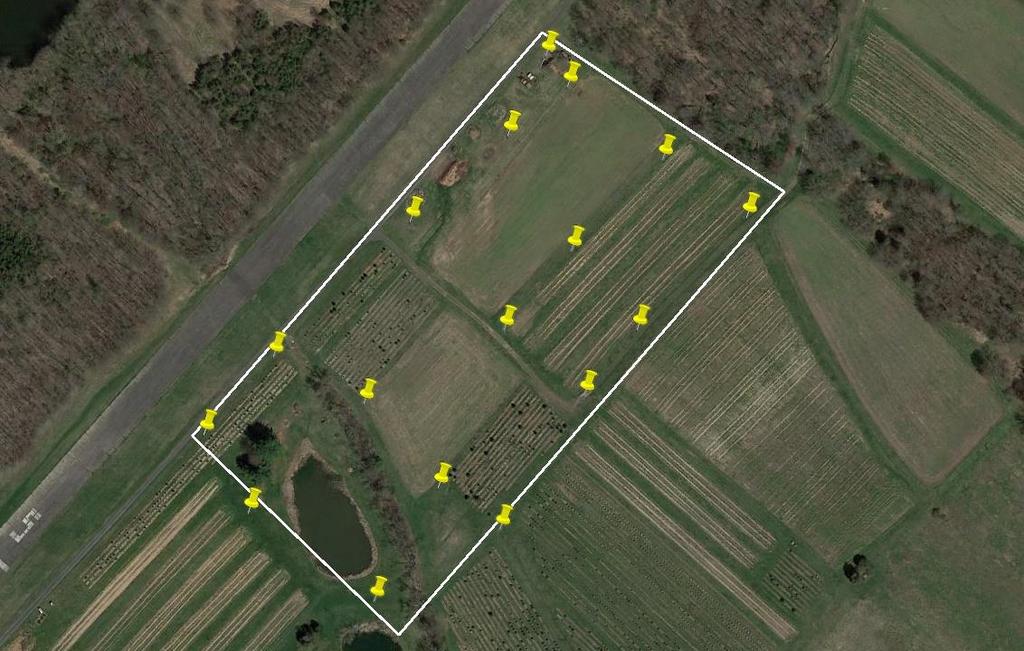
8 Planned Location and Flights AGA Farms in Perkasie, PA 10 acres AOI on 100 acre farm Fully compatible with 333 rules working under at the time
9

10
11 Planned Location and Flights Falcon Prime: 2cm and 4cm 18 ppm2 Altavian RGB: 400ft & 200 ft Altavian CIR: 400ft & 200 ft Mavrik RGB: 200ft & 400 ft (with and without IMU)

12 Planned Location and Flights UltraCam Falcon 2cm GSD Galaxy Flight Plan


13 Planned Location and Flights Altavian MP22 400ft Plan Sony A7r 200ft Plan

14 Timeline Ground Control Placed: June 28 th Galaxy flown: June 29 th 7:44 am local time Altavian: 10:00 10:10 am UltraCam Falcon: 10:33 10:39 am Mavrik: 10:42 10:52 am UltraCam Falcon: 10:46-10:52am Altavian: 11:06 11:20 am Mavrik: 11:45 11:54 am Altavian: 12:14 12:36 pm
15 Capture Statistics Platform Sensor Bands GSD Altitude Lines Images Time Cessna 210 UC FalconP RGBI 4cm 2575 ft min Cessna 210 UC FalconP RGBI 2cm 1375 ft min F6500 Cannon RGB 2.76cm 400 ft min F6500 Cannon RGB 1.38cm 200 ft min F6500 Cannon CIR 2.76cm 400 ft min F6500 Cannon CIR 1.38cm 200 ft min Mavrik Sony RGB 1.47cm 400 ft min Mavrik Sony RGB 0.72cm 200 ft min The Galaxy captured the area in 5 strips in 9 minutes of production flight time. The point density averaged 17.8 points per square meter using a PRF of 300 khz and a scan frequency of 92 Hz at an altitude of 3000 feet AGL.
16 Results of AT RMSE on Check Points DX in cm DY in cm DZ in cm Flight 0 GCP 2GCP 3GCP 0 GCP 2GCP 3GCP 0 GCP 2GCP 3GCP Sony 200ft Sony 400ft Cannon 200ft Cannon 400ft UCFp 1387ft UCFp 2560ft GCPs used resulted in 15 Check Points 2 GCPs used resulted in 13 Check Points 3 GCPs used resulted in 12 Check Points
17 Results of AT RMSE on Check Points DX in cm DY in cm DZ in cm Flight 5GCP 7GCP 10GCP 5GCP 7GCP 10GCP 5GCP 7GCP 10GCP Sony 200ft Sony 400ft Cannon 200ft Cannon 400ft UCFp 1387ft UCFp 2560ft GCPs used resulted in 10 Check Points 7 GCPs used resulted in 8 Check Points 10 GCPs used resulted in 5 Check Points

18 Results of AT All measurements in meters. The UAV residuals are worse for 10 control points with all X and one Y. From 3 GCPs onward for most are at or below the expected accuracy of the control.
19 Results of AT
20 Control Layout Statistics Percentage of RMSE Improvement by GCP Count Flight 3 to 5 x/y 3 to 5 z 5 to 7 x/y 5 to 7 z 5 to 10 x/y 5 to 10 z Sony 200ft -6% 81% 48% -4% 23% 4% Sony 400ft 10% 72% -5% -13% 14% 54% Cannon 200ft 25% 66% 16% 26% 8% 11% Cannon 400ft -14% 57% -14% 10% 12% 10% Mean 4% 69% 11% 5% 14% 20%
21 UltraCam Image Sharpness There was concern that the imagery from the UltraCam Falcon taken in the Cessna 210 could have resulted in image blurring due to heat/exhaust. Although there were no visible signs of blur or fuzziness in the imagery, a standard sharpening was performed on the imagery using the Vexcel UltraMap suite. Standard vs Sharpened Imagery The two UltraCam flights were then run through the same AT as the unsharpened imagery. The results below show that sharpening had a slightly negative impact (generally 2-3 millimeters) and indicates that the imagery was not negatively affected by aircraft heat or exhaust Sharpened RMSE - Standard RMSE No Sharpened is: Better Worse Change No GCP 2GCP 3GCP 5GCP 7GCP 10GCP UCFp 1387ft Dx Dy Dz UCFp 2560ft Dx Dy Dz


22 Study using MEMS IMU with L1 GPS In January of 2017, the area was flown again using new control, a new UAV with the same Sony A7R and Vectornav VN-200
23 Study using MEMS IMU with L1 GPS Due to time and budget constraints, only 5 GCPs were placed with the same methodology Sony A7R flown with DJI M600 at 200ft Raw EO values from the sensor were compared to Controlled AT EO results Raw EO error (raw EO minus controlled adjusted EO) Delta X Delta Y Delta Z Delta Omega Delta Phi Delta Kappa Mean Mean (abs) Min (abs) Max (abs) RMSE
24 Study using IMU with L1 GPS Results of January Flight with M600 UAV at 200 ft. were poor, reasons for this The antenna offsets from the camera to antenna are further on the M600 than with the Marvrik and without being entered, caused GPS error and possibly poor IMU data through the Kalman filter A different FMS was used to trigger the camera that did not rotate the aircraft or camera for each line, so GPS shift/drift cannot be modeled and removed The small number of control points does not lend to a rigorous solution Error on Checkpoints in meters Further study and flights are being conducted to determine methodology to achieve better results RMSE DX DY DZ 0 GCP 5 Check GCP 4 CHECK GCP 3 CHECK GCP 2 CHECK DX in cm DY in cm DZ in cm Flight 0 GCP 2GCP 3GCP 0 GCP 2GCP 3GCP 0 GCP 2GCP 3GCP Sony 200ft June Sony 200ft January
25 Conclusions The Canon 22MP camera mounted on the fixed wing aircraft performed better than the Sony A7R 36MP camera on the rotorcraft in lower control situations. However, with more control, the Sony sensor produced accuracies comparable to the UCFp. Despite the high quality Zeiss 35mm lens on the Sony A7R, the adjustments performed by the software would suggest an instability in the lens. In the case of the Zeiss lens, the situation of less control caused the errors to manifest without the ability to be systematically corrected. For the UltraCam imagery, it is clear that applying sharpening techniques to imagery that is already crisp results in no appreciable improvement for automated aerial triangulation results.
26 Conclusions Control point accuracy is increasingly important as pixel sizes allow for better results. It is increasingly possible to exceed the limits of GPS control The largest improvement in terms of RMSE in Z was from 3 to 5 GCPS (69%) while increasing from 5 to 7 resulted in less impressive improvements in x/y (11%) and z (5%). Using a MEMS IMU with L1 GPS does not show improved results as compared to the navigation GPS and telemetry data on board the UAV The use of a MEMS IMU for systems unable to export location data is an excellent an reliable solution
27 Special Thanks Special thanks must go to Wes Weaver of Keystone Aerial Surveys, Inc. for his commitment to running the same datasets through so many iterations!
28 Thank You! Contact Us David Day: Web: Facebook:
Five Sensors, One Day: Unmanned vs. Manned Logistics and Accuracy
 Five Sensors, One Day: Unmanned vs. Manned Logistics and Accuracy ASPRS UAS Mapping Technical Symposium Sept 13 th, 2016 Presenter: David Day, CP, GISP Keystone Aerial Surveys, Inc. Summary of activities
Overview. Objectives. The ultimate goal is to compare the performance that different equipment offers us in a photogrammetric flight.
 Overview At present, one of the most commonly used technique for topographic surveys is aerial photogrammetry. This technique uses aerial images to determine the geometric properties of objects and spatial
accuracy. You even hear the terms subcentimeter or even millimeter absolute accuracy during some of these
 Question: I would like to get your expert opinion on a dataset I just received. It is UAS-based imagery collected to produce a 50cm Digital Elevation Models (DEM) and 5cm resolution true color orthos.
UltraCam and UltraMap An Update
 Photogrammetric Week '15 Dieter Fritsch (Ed.) Wichmann/VDE Verlag, Belin & Offenbach, 2015 Wiechert, Gruber 45 UltraCam and UltraMap An Update Alexander Wiechert, Michael Gruber, Graz ABSTRACT When UltraCam
Phase One ixu-rs1000 Accuracy Assessment Report Yu. Raizman, PhaseOne.Industrial, Israel
 17 th International Scientific and Technical Conference FROM IMAGERY TO DIGITAL REALITY: ERS & Photogrammetry Phase One ixu-rs1000 Accuracy Assessment Report Yu. Raizman, PhaseOne.Industrial, Israel 1.
2019 NYSAPLS Conf> Fundamentals of Photogrammetry for Land Surveyors
 2019 NYSAPLS Conf> Fundamentals of Photogrammetry for Land Surveyors George Southard GSKS Associates LLC Introduction George Southard: Master s Degree in Photogrammetry and Cartography 40 years working
NEWS FROM THE ULTRACAM CAMERA LINE-UP INTRODUCTION
 NEWS FROM THE ULTRACAM CAMERA LINE-UP Alexander Wiechert, Michael Gruber Vexcel Imaging Austria / Microsoft Photogrammetry Anzengrubergasse 8/4, 8010 Graz / Austria {alwieche, michgrub}@microsoft.com ABSTRACT
Update on UltraCam and UltraMap technology
 Update on UltraCam and UltraMap technology Alexander Wiechert, Michael Gruber Anzengrubergasse 8/4, 8010 Graz, Austria {alexander.wiechert, michael.gruber}@vexcel-imaging.com Stuttgart, September 2017
Calibration Certificate
 Calibration Certificate Digital Mapping Camera (DMC) DMC Serial Number: DMC01-0053 CBU Serial Number: 0100053 For MPPG AERO Sp. z. o. o., ul. Kaczkowskiego 6 33-100 Tarnow Poland System Overview Flight
UltraCam and UltraMap An Update
 Photogrammetric Week '13 Dieter Fritsch (Ed.) Wichmann/VDE Verlag, Belin & Offenbach, 2013 Wiechert 37 UltraCam and UltraMap An Update ALEXANDER WIECHERT, Graz ABSTRACT When UltraCam D was presented first
CALIBRATING THE NEW ULTRACAM OSPREY OBLIQUE AERIAL SENSOR Michael Gruber, Wolfgang Walcher
 CALIBRATING THE NEW ULTRACAM OSPREY OBLIQUE AERIAL SENSOR Michael Gruber, Wolfgang Walcher Microsoft UltraCam Business Unit Anzengrubergasse 8/4, 8010 Graz / Austria {michgrub, wwalcher}@microsoft.com
AIRPORT MAPPING JUNE 2016 EXPLORING UAS EFFECTIVENESS GEOSPATIAL SLAM TECHNOLOGY FEMA S ROMANCE WITH LIDAR VOLUME 6 ISSUE 4
 VOLUME 6 ISSUE 4 JUNE 2016 AIRPORT MAPPING 18 EXPLORING UAS EFFECTIVENESS 29 GEOSPATIAL SLAM TECHNOLOGY 36 FEMA S ROMANCE WITH LIDAR Nearly 2,000 U.S. landfill facilities stand to gain from cost-effective
ACCURACY ASSESSMENT OF DIRECT GEOREFERENCING FOR PHOTOGRAMMETRIC APPLICATIONS ON SMALL UNMANNED AERIAL PLATFORMS
 ACCURACY ASSESSMENT OF DIRECT GEOREFERENCING FOR PHOTOGRAMMETRIC APPLICATIONS ON SMALL UNMANNED AERIAL PLATFORMS O. Mian a, J. Lutes a, G. Lipa a, J. J. Hutton a, E. Gavelle b S. Borghini c * a Applanix
Digital Aerial Photography UNBC March 22, Presented by: Dick Mynen TDB Consultants Inc.
 Digital Aerial Photography UNBC March 22, 2011 Presented by: Dick Mynen TDB Consultants Inc. Airborne Large Scale Digital Photography Who is using the technology in today s environment Options available
** KEYSTONE AERIAL SURVEYS R. David Day, Wesley Weaver **
 AN ACCURACY ANALYSIS OF LARGE RESOLUTION IMAGES CAPTURED WITH THE NIKON D810 DIGITAL CAMERA SYSTEM Ricardo M. Passini * * ricardopassini2012@outlook.com ** KEYSTONE AERIAL SURVEYS R. David Day, Wesley
Baldwin and Mobile Counties, AL Orthoimagery Project Report. Submitted: March 23, 2016
 2015 Orthoimagery Project Report Submitted: Prepared by: Quantum Spatial, Inc 523 Wellington Way, Suite 375 Lexington, KY 40503 859-277-8700 Page i of iii Contents Project Report 1. Summary / Scope...
Consumer digital CCD cameras
 CAMERAS Consumer digital CCD cameras Leica RC-30 Aerial Cameras Zeiss RMK Zeiss RMK in aircraft Vexcel UltraCam Digital (note multiple apertures Lenses for Leica RC-30. Many elements needed to minimize
Validation of the QuestUAV PPK System
 Validation of the QuestUAV PPK System 3cm in xy, 400ft, no GCPs, 100Ha, 25 flights Nigel King 1, Kerstin Traut 2, Cameron Weeks 3 & Ruairi Hardman 4 1 Director QuestUAV, 2 Data Analyst QuestUAV, 3 Production
EnsoMOSAIC Aerial mapping tools
 EnsoMOSAIC Aerial mapping tools Jakarta and Kuala Lumpur, 2013 Contents MosaicMill MM Application examples Software introduction System introduction Rikola HS sensor UAV platform examples SW Syst HS UAV
Phase One 190MP Aerial System
 White Paper Phase One 190MP Aerial System Introduction Phase One Industrial s 100MP medium format aerial camera systems have earned a worldwide reputation for its high performance. They are commonly used
Rochester Institute of Technology. Wildfire Airborne Sensor Program (WASP) Project Overview
 Project Overview") Rochester Institute of Technology Wildfire Airborne Sensor Program (WASP) Project Overview Introduction The following slides describe a program underway at RIT The sensor system described herein is being
Rochester Institute of Technology Wildfire Airborne Sensor Program (WASP) Project Overview Introduction The following slides describe a program underway at RIT The sensor system described herein is being
Calibration Report. UC-SXp Version of Report:
 Calibration Report Camera: Serial: UltraCam Xp UC-SXp-1-40719017 Calibration Date: Date of Report: Camera Revision: Version of Report: Feb-28-2018 Mar-05-2018 Rev13.00 V01 www.vexcel-imaging.com Copyright
ULTRACAM EAGLE MARK 3. One system for endless possibilities
 ULTRACAM EAGLE MARK 3 One system for endless possibilities ULTRACAM EAGLE MARK 3 26,460 pixels across track An ultra-large footprint coupled with a unique user-exchangeable lens system makes the UltraCam
Vexcel Imaging GmbH Innovating in Photogrammetry: UltraCamXp, UltraCamLp and UltraMap
 Photogrammetric Week '09 Dieter Fritsch (Ed.) Wichmann Verlag, Heidelberg, 2009 Wiechert, Gruber 27 Vexcel Imaging GmbH Innovating in Photogrammetry: UltraCamXp, UltraCamLp and UltraMap ALEXANDER WIECHERT,
UltraCam and UltraMap Towards All in One Solution by Photogrammetry
 Photogrammetric Week '11 Dieter Fritsch (Ed.) Wichmann/VDE Verlag, Belin & Offenbach, 2011 Wiechert, Gruber 33 UltraCam and UltraMap Towards All in One Solution by Photogrammetry ALEXANDER WIECHERT, MICHAEL
UltraCam Eagle Prime Aerial Sensor Calibration and Validation
 UltraCam Eagle Prime Aerial Sensor Calibration and Validation Michael Gruber, Marc Muick Vexcel Imaging GmbH Anzengrubergasse 8/4, 8010 Graz / Austria {michael.gruber, marc.muick}@vexcel-imaging.com Key
Leica - 3 rd Generation Airborne Digital Sensors Features / Benefits for Remote Sensing & Environmental Applications
 Leica - 3 rd Generation Airborne Digital Sensors Features / Benefits for Remote Sensing & Environmental Applications Arthur Rohrbach, Sensor Sales Dir Europe, Middle-East and Africa (EMEA) Luzern, Switzerland,
The Airphoto Ortho Suite is an add-on to Geomatica. It requires Geomatica Core or Geomatica Prime as a pre-requisite.
 Airphoto Ortho Suite The Airphoto Ortho Suite includes rigorous models used to correct the geometry of analogue and digital/video cameras and to produce orthorectified air photos. These models compensate
UAV Technologies for 3D Mapping. Rolf Schaeppi Director Geospatial Solutions APAC / India
 UAV Technologies for 3D Mapping Rolf Schaeppi Director Geospatial Solutions APAC / India Some main application areas? Market situation Analyst statements billion dollars 7,3 defense market 2,5 civil market
Aerial efficiency, photogrammetric accuracy
 Aerial efficiency, photogrammetric accuracy Why sensefly 3 reasons to choose the ebee Plus Large coverage for optimal efficiency The ebee Plus can map more square kilometres per flight, than any drone
RPAS Photogrammetric Mapping Workflow and Accuracy
 RPAS Photogrammetric Mapping Workflow and Accuracy Dr Yincai Zhou & Dr Craig Roberts Surveying and Geospatial Engineering School of Civil and Environmental Engineering, UNSW Background RPAS category and
Full Waveform Digitizing, Dual Channel Airborne LiDAR Scanning System for Ultra Wide Area Mapping
 Full Waveform Digitizing, Dual Channel Airborne LiDAR Scanning System for Ultra Wide Area Mapping RIEGL LMS-Q56 high laser pulse repetition rate up to 8 khz digitization electronics for full waveform data
Deliverable 5-B: Review and Update on AURA System Requirements, Sensors, and Platforms Supplemental Report
 Deliverable 5-B: Review and Update on AURA System Requirements, Sensors, and Platforms Supplemental Report Focusing on education, research, and development of technology to sense and understand natural
Experimental aerial photogrammetry with professional non metric camera Canon EOS 5D
 Experimental aerial photogrammetry with professional non metric camera Canon EOS 5D Ante Sladojević, Goran Mrvoš Galileo Geo Sustavi, Croatia 1. Introduction With this project we wanted to test professional
AERIAL SURVEY TEST PROJECT WITH DJI PHANTOM 3 QUADROCOPTER DRONE
 T. Jancso, P. Engler, P. Udvardy Aerial Survey Test Project with DJI Phantom 3 Quadrocopter Drone AERIAL SURVEY TEST PROJECT WITH DJI PHANTOM 3 QUADROCOPTER DRONE Tamas JANCSO, Associate Professor Phd
Geo-localization and Mosaicing System (GEMS): Enabling Precision Image Feature Location and Rapid Mosaicing General:
: Enabling Precision Image Feature Location and Rapid Mosaicing General:") Geo-localization and Mosaicing System (GEMS): Enabling Precision Image Feature Location and Rapid Mosaicing General: info@senteksystems.com www.senteksystems.com 12/6/2014 Precision Agriculture Multi-Spectral
Geo-localization and Mosaicing System (GEMS): Enabling Precision Image Feature Location and Rapid Mosaicing General: info@senteksystems.com www.senteksystems.com 12/6/2014 Precision Agriculture Multi-Spectral
HIGH RESOLUTION COLOR IMAGERY FOR ORTHOMAPS AND REMOTE SENSING. Author: Peter Fricker Director Product Management Image Sensors
 HIGH RESOLUTION COLOR IMAGERY FOR ORTHOMAPS AND REMOTE SENSING Author: Peter Fricker Director Product Management Image Sensors Co-Author: Tauno Saks Product Manager Airborne Data Acquisition Leica Geosystems
The drone for precision agriculture
 The drone for precision agriculture Reap the benefits of scouting crops from above If precision technology has driven the farming revolution of recent years, monitoring crops from the sky will drive the
OLC Turnbull. wsidata.com
 OLC Turnbull wsidata.com August 26, 2013 Base station set up over control TURN_03 Data collected for: Department of Geology and Mineral Industries 800 NE Oregon Street Suite 965 Portland, OR 97232 Prepared
SENSITIVITY ANALYSIS OF UAV-PHOTOGRAMMETRY FOR CREATING DIGITAL ELEVATION MODELS (DEM)
") SENSITIVITY ANALYSIS OF UAV-PHOTOGRAMMETRY FOR CREATING DIGITAL ELEVATION MODELS (DEM) G. Rock a, *, J.B. Ries b, T. Udelhoven a a Dept. of Remote Sensing and Geomatics. University of Trier, Behringstraße,
SENSITIVITY ANALYSIS OF UAV-PHOTOGRAMMETRY FOR CREATING DIGITAL ELEVATION MODELS (DEM) G. Rock a, *, J.B. Ries b, T. Udelhoven a a Dept. of Remote Sensing and Geomatics. University of Trier, Behringstraße,
Leica ADS80 - Digital Airborne Imaging Solution NAIP, Salt Lake City 4 December 2008
 Luzern, Switzerland, acquired at 5 cm GSD, 2008. Leica ADS80 - Digital Airborne Imaging Solution NAIP, Salt Lake City 4 December 2008 Shawn Slade, Doug Flint and Ruedi Wagner Leica Geosystems AG, Airborne
UAV PHOTOGRAMMETRY COMPARED TO TRADITIONAL RTK GPS SURVEYING
 UAV PHOTOGRAMMETRY COMPARED TO TRADITIONAL RTK GPS SURVEYING Brad C. Mathison and Amber Warlick March 20, 2016 Fearless Eye Inc. Kansas City, Missouri www.fearlesseye.com KEY WORDS: UAV, UAS, Accuracy
Calibration Report. Short Version. UltraCam L, S/N UC-L Vexcel Imaging GmbH, A-8010 Graz, Austria
 Calibration Report Short Version Camera: Manufacturer: UltraCam L, S/N UC-L-1-00612089 Vexcel Imaging GmbH, A-8010 Graz, Austria Date of Calibration: Mar-23-2010 Date of Report: May-17-2010 Camera Revision:
White Paper Reaching 1 cm (0.4 in) drone survey accuracy
 drone survey accuracy") White Paper Reaching 1 cm (0.4 in) drone survey accuracy 3x higher absolute accuracy with WingtraOne Latest tests in USA and Switzerland prove that the VTOL WingtraOne drone repeatably reaches the best-in-class
White Paper Reaching 1 cm (0.4 in) drone survey accuracy 3x higher absolute accuracy with WingtraOne Latest tests in USA and Switzerland prove that the VTOL WingtraOne drone repeatably reaches the best-in-class
OLC West Metro. wsidata.com
 OLC West Metro wsidata.com February 19, 2013 Hillsboro Airport, LiDAR point cloud Data collected for: Department of Geology and Mineral Industries 800 NE Oregon Street Suite 965 Portland, OR 97232 Prepared
NAVIGATION AND REMOTE SENSING PAYLOADS AND METHODS OF THE SARVANT UNMANNED AERIAL SYSTEM
 NAVIGATION AND REMOTE SENSING PAYLOADS AND METHODS OF THE SARVANT UNMANNED AERIAL SYSTEM P. Molina, P. Fortuny, I. Colomina Institute of Geomatics -- Castelldefels (ES) M. Remy, K.A.C. Macedo, Y.R.C. Zúnigo,
POTENTIAL OF LARGE FORMAT DIGITAL AERIAL CAMERAS. Dr. Karsten Jacobsen Leibniz University Hannover, Germany
 POTENTIAL OF LARGE FORMAT DIGITAL AERIAL CAMERAS Dr. Karsten Jacobsen Leibniz University Hannover, Germany jacobsen@ipi.uni-hannover.de Introduction: Digital aerial cameras are replacing traditional analogue
National Oceanic and Atmospheric Administration (NOAA) Small Unmanned Aircraft Systems (suas) Avon Park Demonstration Executive Summary
 Small Unmanned Aircraft Systems (suas) Avon Park Demonstration Executive Summary") (NOAA) (suas) Avon Park Demonstration Executive Summary Contents 1.0 Background... 1 2.0 Objective... 1 3.0 Test Site... 2 4.0 Observations... 2 5.0 System Observations... 3 SenseFly ebee:... 3 AV Puma
(NOAA) (suas) Avon Park Demonstration Executive Summary Contents 1.0 Background... 1 2.0 Objective... 1 3.0 Test Site... 2 4.0 Observations... 2 5.0 System Observations... 3 SenseFly ebee:... 3 AV Puma
Calibration Report. Short Version. UltraCam Eagle, S/N UC-E f210. Vexcel Imaging GmbH, A-8010 Graz, Austria
 Calibration Report Short Version Camera: Manufacturer: Date of Calibration: Date of Report: Revision of Camera: Version of Report: UltraCam Eagle, S/N UC-E-1-00518105-f210 Vexcel Imaging GmbH, A-8010 Graz,
Sampling the World in 3D by Airborne LIDAR Assessing the Information Content of LIDAR Point Clouds
 Sampling the World in 3D by Airborne LIDAR Assessing the Information Content of LIDAR Point Clouds PhoWo 2013 September 11 th, 2013 Stuttgart, Germany Andreas Ullrich RIEGL LMS GmbH sequential data acquisition
White Paper Reaching 1 cm (0.4 in) drone survey accuracy
 drone survey accuracy") White Paper Reaching 1 cm (0.4 in) drone survey accuracy 3x higher absolute accuracy with WingtraOne Latest tests in USA and Switzerland prove that the VTOL WingtraOne drone repeatably reaches the best-in-class
White Paper Reaching 1 cm (0.4 in) drone survey accuracy 3x higher absolute accuracy with WingtraOne Latest tests in USA and Switzerland prove that the VTOL WingtraOne drone repeatably reaches the best-in-class
Calibration Report. UltraCam Eagle, S/N UC-Eagle f80. Vexcel Imaging GmbH, A-8010 Graz, Austria
 Calibration Report Camera: Manufacturer: UltraCam Eagle, S/N UC-Eagle-1-60411397-f80 Vexcel Imaging GmbH, A-8010 Graz, Austria Date of Calibration: Jul-23-2013 Date of Report: Aug-06-2013 Camera Revision:
White Paper Reaching 1 cm (0.4 in) drone survey accuracy
 drone survey accuracy") White Paper Reaching 1 cm (0.4 in) drone survey accuracy 3x higher absolute accuracy with WingtraOne Latest tests in the USA and Switzerland prove that the VTOL WingtraOne drone repeatedly reaches the
White Paper Reaching 1 cm (0.4 in) drone survey accuracy 3x higher absolute accuracy with WingtraOne Latest tests in the USA and Switzerland prove that the VTOL WingtraOne drone repeatedly reaches the
Aerial Image Acquisition and Processing Services. Ron Coutts, M.Sc., P.Eng. RemTech, October 15, 2014
 Aerial Image Acquisition and Processing Services Ron Coutts, M.Sc., P.Eng. RemTech, October 15, 2014 Outline Applications & Benefits Image Sources Aircraft Platforms Image Products Sample Images & Comparisons
MEDIUM FORMAT CAMERA EVALUATION BASED ON THE LATEST PHASE ONE TECHNOLOGY
 MEDIUM FORMAT CAMERA EVALUATION BASED ON THE LATEST PHASE ONE TECHNOLOGY T.Tölg a, G. Kemper b, D. Kalinski c a Phase One / Germany tto@phaseone.com b GGS GmbH, Speyer / Germany kemper@ggs-speyer.de c
Objectives: 1. Assess the feasibility of using high spatial resolution image data for counting male Common Eiders.
 Sea Duck Joint Venture Annual Project Summary FY 2016 - (1 April 2016-31 March 2017) Cooperative Agreement F12AC01228 Project Title: Sea Duck Research and Monitoring in the Atlantic Flyway: Development
Digital airborne cameras Status & future
 Institut für Photogrammetrie ifp Digital airborne cameras Status & future Michael Cramer Institute for Photogrammetry, Univ. of Stuttgart Geschwister-Scholl-Str.24, D-70174 Stuttgart Tel: + 49 711 121
Dual Channel Waveform Processing Airborne LiDAR Scanning System for High Point Density and Ultra Wide Area Mapping
 Dual Channel Waveform Processing Airborne LiDAR Scanning System for High Point Density and Ultra Wide Area Mapping RIEGL VQ-156i high laser pulse repetition rate: up to 2 MHz up to 1.33 million measurements
Inertial Sensors. Ellipse Series MINIATURE HIGH PERFORMANCE. Navigation, Motion & Heave Sensing IMU AHRS MRU INS VG
 Ellipse Series MINIATURE HIGH PERFORMANCE Inertial Sensors IMU AHRS MRU INS VG ITAR Free 0.1 RMS Navigation, Motion & Heave Sensing ELLIPSE SERIES sets up new standard for miniature and cost-effective
Jens Kremer ISPRS Hannover Workshop 2017,
 Jens Kremer ISPRS Hannover Workshop 2017, 8.06.2017 Modular aerial camera-systems The IGI UrbanMapper 2-in1 concept System Layout The DigiCAM-100 module The IGI UrbanMapper Sensor geometry & stitching
Camera Calibration Certificate No: DMC IIe
 Calibration DMC IIe 230 23522 Camera Calibration Certificate No: DMC IIe 230 23522 For Richard Crouse & Associates 467 Aviation Way Frederick, MD 21701 USA Calib_DMCIIe230-23522.docx Document Version 3.0
VisionMap Sensors and Processing Roadmap
 Vilan, Gozes 51 VisionMap Sensors and Processing Roadmap YARON VILAN, ADI GOZES, Tel-Aviv ABSTRACT The A3 is a family of digital aerial mapping cameras and photogrammetric processing systems, which is
HD aerial video for coastal zone ecological mapping
 HD aerial video for coastal zone ecological mapping Albert K. Chong University of Otago, Dunedin, New Zealand Phone: +64 3 479-7587 Fax: +64 3 479-7586 Email: albert.chong@surveying.otago.ac.nz Presented
Flood modelling and management. Glasgow University. 8 September Paul Shaw - GeoVision
 Flood modelling and management Glasgow University 8 September 2004 Paul Shaw - GeoVision How important are heights in flood modelling? Comparison of data collection technologies GPS - Global Positioning
How Farmer Can Utilize Drone Mapping?
 Presented at the FIG Working Week 2017, May 29 - June 2, 2017 in Helsinki, Finland How Farmer Can Utilize Drone Mapping? National Land Survey of Finland Finnish Geospatial Research Institute Roope Näsi,
PROPERTY OF THE LARGE FORMAT DIGITAL AERIAL CAMERA DMC II
 PROPERTY OF THE LARGE FORMAT DIGITAL AERIAL CAMERA II K. Jacobsen a, K. Neumann b a Institute of Photogrammetry and GeoInformation, Leibniz University Hannover, Germany jacobsen@ipi.uni-hannover.de b Z/I
Inertial Sensors. Ellipse Series MINIATURE HIGH PERFORMANCE. Navigation, Motion & Heave Sensing IMU AHRS MRU INS VG
 Ellipse Series MINIATURE HIGH PERFORMANCE Inertial Sensors IMU AHRS MRU INS VG ITAR Free 0.2 RMS Navigation, Motion & Heave Sensing ELLIPSE SERIES sets up new standard for miniature and cost-effective
Remote Sensing Platforms
 Types of Platforms Lighter-than-air Remote Sensing Platforms Free floating balloons Restricted by atmospheric conditions Used to acquire meteorological/atmospheric data Blimps/dirigibles Major role - news
Camera Calibration Certificate No: DMC II
 Calibration DMC II 140-036 Camera Calibration Certificate No: DMC II 140-036 For Midwest Aerial Photography 7535 West Broad St, Galloway, OH 43119 USA Calib_DMCII140-036.docx Document Version 3.0 page
LiDAR Remote Sensing Data Collection Department of Geology and Mineral Industries Mt. Shasta Study Area February 2, 2011
 LLiiD DA AR RR Reem moottee SSeennssiinngg D Daattaa C Coolllleeccttiioonn D Deeppaarrttm meenntt ooff G Geeoollooggyy aanndd M Miinneerraall IInndduussttrriieess M Mtt.. SShhaassttaa SSttuuddyy A Arreeaa
Camera Calibration Certificate No: DMC II
 Calibration DMC II 230 015 Camera Calibration Certificate No: DMC II 230 015 For Air Photographics, Inc. 2115 Kelly Island Road MARTINSBURG WV 25405 USA Calib_DMCII230-015_2014.docx Document Version 3.0
Camera Calibration Certificate No: DMC II
 Calibration DMC II 140-005 Camera Calibration Certificate No: DMC II 140-005 For Midwest Aerial Photography 7535 West Broad St, Galloway, OH 43119 USA Calib_DMCII140-005.docx Document Version 3.0 page
NEW. Airborne Laser Scanning. Dual Wavelength Waveform Processing Airborne LiDAR Scanning System for High-Point Density Mapping Applications
 Dual Wavelength Waveform Processing Airborne LiDAR Scanning System for High-Point Density Mapping Applications NEW RIEGL VQ-156i-DW enhanced target characterization based upon simultaneous measurements
Monitoring water pollution in the river Ganga with innovations in airborne remote sensing and drone technology
 Monitoring water pollution in the river Ganga with innovations in airborne remote sensing and drone technology RAJIV SINHA, DIPRO SARKAR DEPARTMENT OF EARTH SCIENCES, INDIAN INSTITUTE OF TECHNOLOGY KANPUR,
PHOTOGRAMMETRIC RESECTION DIFFERENCES BASED ON LABORATORY vs. OPERATIONAL CALIBRATIONS
 PHOTOGRAMMETRIC RESECTION DIFFERENCES BASED ON LABORATORY vs. OPERATIONAL CALIBRATIONS Dean C. MERCHANT Topo Photo Inc. Columbus, Ohio USA merchant.2@osu.edu KEY WORDS: Photogrammetry, Calibration, GPS,
Camera Calibration Certificate No: DMC II
 Calibration DMC II 230 027 Camera Calibration Certificate No: DMC II 230 027 For Peregrine Aerial Surveys, Inc. 103-20200 56 th Ave Langley, BC V3A 8S1 Canada Calib_DMCII230-027.docx Document Version 3.0
MINNESOTA DEPARTMENT OF TRANSPORTATION OFFICE OF LAND MANAGEMENT SURVEYING AND MAPPING SECTION PHOTOGRAMMETRY UNIT
 SEP. 2011 MINNESOTA DEPARTMENT OF TRANSPORTATION OFFICE OF LAND MANAGEMENT SURVEYING AND MAPPING SECTION PHOTOGRAMMETRY UNIT SPECIAL PROVISIONS FOR: GROUP 1: AERIAL PHOTOGRAPHY/PHOTOGRAMMETRIC LAB SERVICES
Dual Channel Waveform Processing Airborne LiDAR Scanning System for High-Point Density and Ultra-Wide Area Mapping
 Dual Channel Waveform Processing Airborne LiDAR Scanning System for High-Point Density and Ultra-Wide Area Mapping RIEGL VQ-156i high laser pulse repetition rate up to 2 MHz up to 1.33 million measurements
Camera Calibration Certificate No: DMC II Aero Photo Europe Investigation
 Calibration DMC II 250 030 Camera Calibration Certificate No: DMC II 250 030 For Aero Photo Europe Investigation Aerodrome de Moulins Montbeugny Yzeure Cedex 03401 France Calib_DMCII250-030.docx Document
Camera Calibration Certificate No: DMC II
 Calibration DMC II 230 020 Camera Calibration Certificate No: DMC II 230 020 For MGGP Aero Sp. z o.o. ul. Słowackiego 33-37 33-100 Tarnów Poland Calib_DMCII230-020.docx Document Version 3.0 page 1 of 40
FLIGHT SUMMARY REPORT
 FLIGHT SUMMARY REPORT Flight Number: 97-011 Calendar/Julian Date: 23 October 1996 297 Sensor Package: Area(s) Covered: Wild-Heerbrugg RC-10 Airborne Visible and Infrared Imaging Spectrometer (AVIRIS) Southern
Calibration Report. Short version. UltraCam Xp, S/N UC-SXp Vexcel Imaging GmbH, A-8010 Graz, Austria
 Calibration Report Short version Camera: Manufacturer: UltraCam Xp, S/N UC-SXp-1-61212452 Vexcel Imaging GmbH, A-8010 Graz, Austria Date of Calibration: Mar-05-2009 Date of Report: Mar-13-2009 Camera Revision:
Planet Labs Inc 2017 Page 2
 SKYSAT IMAGERY PRODUCT SPECIFICATION: ORTHO SCENE LAST UPDATED JUNE 2017 SALES@PLANET.COM PLANET.COM Disclaimer This document is designed as a general guideline for customers interested in acquiring Planet
Hyper-spectral, UHD imaging NANO-SAT formations or HAPS to detect, identify, geolocate and track; CBRN gases, fuel vapors and other substances
 Hyper-spectral, UHD imaging NANO-SAT formations or HAPS to detect, identify, geolocate and track; CBRN gases, fuel vapors and other substances Arnold Kravitz 8/3/2018 Patent Pending US/62544811 1 HSI and
DEM Generation Using a Digital Large Format Frame Camera
 DEM Generation Using a Digital Large Format Frame Camera Joachim Höhle Abstract Progress in automated photogrammetric DEM generation is presented. Starting from the procedures and the performance parameters
While film cameras still
 aerial perspective by Mathias Lemmens, editor-in-chief, GIM International Digital Aerial Cameras System Configurations and Sensor Architectures Editor s note: This issue includes an extensive product survey
Airborne High-resolution, Panoramic Camera Systems Floating Debris Detection
 SR-71 Optical Bar Film Camera NASA WB-57 Argus Digital Camera Airborne High-resolution, Panoramic Camera Systems Floating Debris Detection John Arvesen January 20, 2016 Marine Debris Mapping System - Guidelines
Aerial Triangulation Radiometry Essentials Dense Matching Ortho Generation
 Radiometry Aerial Triangulation Essentials Dense Matching Ortho Generation Highly advanced photogrammetric workflow system for UltraCam images. Microsoft UltraMap is a state-of-the-art, end-to-end, complete
Inertial Sensors. Ellipse 2 Series MINIATURE HIGH PERFORMANCE. Navigation, Motion & Heave Sensing IMU AHRS MRU INS VG
 Ellipse 2 Series MINIATURE HIGH PERFORMANCE Inertial Sensors IMU AHRS MRU INS VG ITAR Free 0.1 RMS Navigation, Motion & Heave Sensing ELLIPSE SERIES sets up new standard for miniature and cost-effective
Monitoring the vegetation success of a rehabilitated mine site using multispectral UAV imagery. Tim Whiteside & Renée Bartolo, eriss
 Monitoring the vegetation success of a rehabilitated mine site using multispectral UAV imagery Tim Whiteside & Renée Bartolo, eriss About the Supervising Scientist Main roles Working to protect the environment
FLCS V2.1. AHRS, Autopilot, Gyro Stabilized Gimbals Control, Ground Control Station
 AHRS, Autopilot, Gyro Stabilized Gimbals Control, Ground Control Station The platform provides a high performance basis for electromechanical system control. Originally designed for autonomous aerial vehicle
LPIS Orthoimagery An assessment of the Bing imagery for LPIS purpose
 LPIS Orthoimagery An assessment of the Bing imagery for LPIS purpose Slavko Lemajić Wim Devos, Pavel Milenov GeoCAP Action - MARS Unit - JRC Ispra Tallinn, 24 th November 2011 Outline JRC`s Ortho specifications
Abstract Quickbird Vs Aerial photos in identifying man-made objects
 Abstract Quickbird Vs Aerial s in identifying man-made objects Abdullah Mah abdullah.mah@aramco.com Remote Sensing Group, emap Division Integrated Solutions Services Department (ISSD) Saudi Aramco, Dhahran
RIEGL VQ -780i NEW. Airborne Laser Scanning. Waveform Processing Airborne Laser Scanner for Ultra Wide Area Mapping and High Productivity.
 Waveform Processing Airborne Laser Scanner for Ultra Wide Area Mapping and High Productivity. NEW RIEGL VQ -78i online waveform processing as well as smart and full waveform recording excellent multiple
USE OF IMPROVISED REMOTELY SENSED DATA FROM UAV FOR GIS AND MAPPING, A CASE STUDY OF GOMA CITY, DR CONGO
 USE OF IMPROVISED REMOTELY SENSED DATA FROM UAV FOR GIS AND MAPPING, A CASE STUDY OF GOMA CITY, DR CONGO Cung Chin Thang United Nations Global Support Center, Brindisi, Italy, Email: thang@un.org KEY WORDS:
Scaling Up Drone Science for Agriculture & Nature Resources through Cooperative Extension
 Scaling Up Drone Science for Agriculture & Nature Resources through Cooperative Extension Andy Lyons, Maggi Kelly, Sean Hogan, Shane Feirer, Robert Johnson CalGIS 2017, Oakland, CA. May 23, 2017 How and
The survey-grade mapping drone
 The survey-grade mapping drone 3 reasons to choose the ebee RTK 01. Survey-grade accuracy Absolute orthomosaic / Digital Elevation Model accuracy of down to 3 cm (1.2 in) without the need for GCPs meaning
TELLS THE NUMBER OF PIXELS THE TRUTH? EFFECTIVE RESOLUTION OF LARGE SIZE DIGITAL FRAME CAMERAS
 TELLS THE NUMBER OF PIXELS THE TRUTH? EFFECTIVE RESOLUTION OF LARGE SIZE DIGITAL FRAME CAMERAS Karsten Jacobsen Leibniz University Hannover Nienburger Str. 1 D-30167 Hannover, Germany jacobsen@ipi.uni-hannover.de
NEW. Airborne Laser Scanning. Waveform Processing Airborne Laser Scanner for Wide Area Mapping and High Productivity. visit our website
 Waveform Processing Airborne Laser Scanner for Wide Area Mapping and High Productivity. NEW RIEGL VQ -780i online waveform processing as well as smart and full waveform recording excellent multiple target