While film cameras still
|
|
|
- Joel Cecil Mills
- 5 years ago
- Views:
Transcription

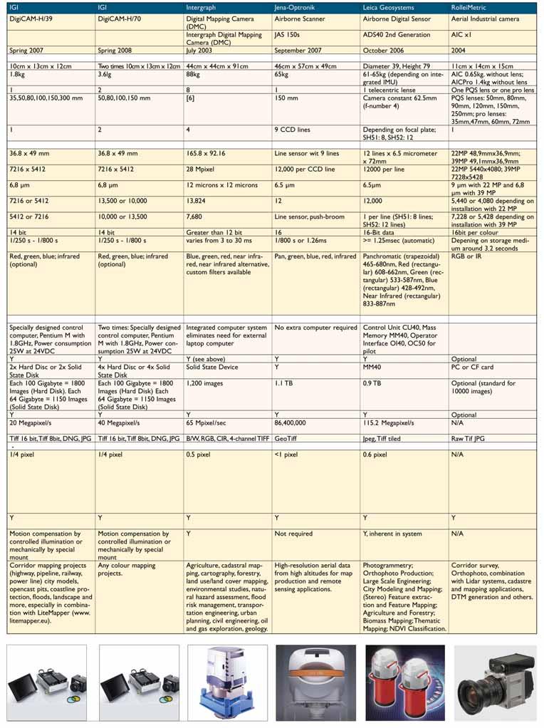
1 aerial perspective by Mathias Lemmens, editor-in-chief, GIM International Digital Aerial Cameras System Configurations and Sensor Architectures Editor s note: This issue includes an extensive product survey on digital aerial cameras, reprinted from our sister publication, GIM International. In support of the specifications is additional information below on system configuration and sensor architecture of the camera systems from nine manufacturers. While film cameras still have their place and may stick around for awhile longer, digital aerial cameras are seeing increased use and offer clear advantages. For starters, this includes better radiometric performance and elimination of film processing and scanning costs. Availability of image content in digital format enables a highly automated workflow, creating the possibility of generating photogrammetry products such as orthophotos/mosaics with little delay between capture and end product. This might allow, for example, for rapid response after a disaster. Linear and Area Twelve-bit-per-pixel radiometric resolution, or even higher, ensures better light sensitivity. The use of image enhancement techniques means details can be made visible in parts of the imagery made bright by reflections or overcast and dark due to shadow or cloud. This relative insensitivity to unfavorable light conditions also enables extension of the daily time-span during which images can be taken and of flight season. It also allows data collection on overcast days, thus optimizing aerial survey productivity and area coverage. Basically, the architecture of a digital area camera consists either of linear CCD arrays or area CCD chips placed in the focal plane. The linear-array architecture, also called the pushbroom scanner, principally employs a single lens head. Color (or multi-spectral band capture) is obtained by placing three or more linear arrays in the focal plane, upon each of which are projected different parts of the visible and near-infrared electromagnetic spectrum. Beam-splitters are used for this. The area CCD array solution is camera architecture consisting of several (multi-head) cones. Since linear- and area-array solutions are the most important features of camera architecture, the camera systems from various manufacturers are grouped accordingly. Area Array Acronyms CIR GSD MP PDA RGB Color Infrared Ground Sample Distance Mega pixels Personal Digital Assistant Red, Green, Blue Applanix The two Applanix Digital Sensor Systems (DSS) consist of completely integrated medium-sized digital camera, GPS-aided INS direct georeferencing system (POS AV), and flight-management system software for generating orthomosaics (Figure 1). POS AV provides the exterior orientation parameters in both real-time and post-mission mode. Although primarily used to generate high-resolution color and color infrared digital orthophotos/mosaics using POS AV data and an existing digital elevation model (DEM), the system also supports full stereo imagery for DEM extraction and visualization. The data interfaces directly and seamlessly with photogrammetry software to allow for fast map production. The DSS 322 array measures 5,436 pixels across and 4,092 along the flight line (in total 22MP); for the DSS 439 these figures are 7,216 and 5412 pixels respectively (39MP). The pixel size of the DSS 322 is 9µm and of the DSS µm, so that the field of view of both is the same. GSD ranges from 3.3cm to 1.0m, depending on platform and using 40mm and 60mm lenses. The DSS system sensor heads weigh about 7kg; they are thus medium-sized and presented by the manufacturer as complementary to large-format digital cameras. They can be flown in small, low-cost, light aircraft or helicopters. The application areas vary from updating and maintaining cadastral databases to rapid response for disaster management. DIMAC Systems Each camera of the DiMAC system acquires one RGB or one near infrared image via one CCD (7,216 x 5,412 pixels) through one lens. The lens may be one of three focal lengths: 55mm, 80mm, 100m or 120mm. GSD ranges from 2cm to 1m. The camera cylindri- Figure 1 Configuration of the Applanix Digital Sensor System DSS
 allows for combining up to four camera modules (CM).")
 by 7,200 pixels (Figure 2b). Two additional CMs may be placed in the vacant holes (Figure 2c), resulting in an image of 10,500 by 14,400 pixels.")
. IGI With dimensions of 10cm x 13cm x 12 cm and weighing 1.")
2 Figure 2a Figure 2b Figures 2a - 2d The DiMAC architecture allows combining up to four camera modules, including a combination of two RGB cameras and one near infrared (right). Figure 2c Figure 2d cal frame (CCF) allows for combining up to four camera modules (CM). A light architecture may be constructed using just one camera in the CCF (Figure 2a), but two cameras (CM1 and CM2) may also be placed here, creating a RGB image of slightly less than twice 5,412 pixels (10,500 pixels) by 7,200 pixels (Figure 2b). Two additional CMs may be placed in the vacant holes (Figure 2c), resulting in an image of 10,500 by 14,400 pixels. Another configuration is formed by adding a near infrared in CM2 covering the same area as that in CM1 or by placing a 55-mm near infrared camera in CM3 covering the same area as CM1 and CM2 together (Figure 2d). IGI With dimensions of 10cm x 13cm x 12 cm and weighing 1.8kg, the IGI DigiCAM system is a medium-sized system which combines modified professional digital cameras with a graphical user interface for real-time preview together with the CCNS/AEROcontrol (Figure 3). Two or more DigiCAMs can be coupled to increase image size. Each 39 MP area CCD chip (7,216 x 5,412 pixels) pixel is sized 6.8µm. Camera settings are adjusted by checking quick-views and histograms of images in real time. For pre-planned flight missions the camera is triggered by the CCNS4 system. Determination of exterior orientation parameters is done using the AEROcontrol GPS/IMU system, each capable of monitoring one or more cameras mounted in a pod. In the case of multiple cameras, synchronisation can be carried out within a few microseconds. Each of the two storage units onboard can store 1,800 images in 16-bit color and full resolution and be exchanged during flight to extend storage capacity. Standard units may be replaced for high-altitude flights by flash memory units with 1,150-image capacity. The DigiControl computer itself does not operate any hard disks. The lenses include (maximal aperture/focal length): 4.5/300mm, 3.2/150mm, 2.2/100mm, 2.8/80mm, 3.5/50mm, 3.5/35mm and 4.0/28mm. The modular design enables a change from RGB mode to color-infrared within minutes for all lenses. The maximum image repetition rate is 0.52 images per second; a higher rate can be reached for a small number of subsequent images ( burst mode ). Intergraph The architecture of Intergraph s digital mapping camera (DMC) amalgamates eight individual CCD array camera modules into autonomous units (Figure 4). Separate lenses are used for each of the eight camera heads, and a rigid optics frame ensures precise alignment of the optical axes. Four of the eight camera modules are equipped with 120-mm lenses and capture panchromatic images on four area-ccd chips 7,000 x 4,000 pixels. The other four cameras simultaneously capture the three color bands (RGB) and the near infrared band on 3,000 x 2,000 CCD chips. The multi-spectral cameras are equipped with 25-mm lenses (wide-angle). Microsoft/Vexcel The Vexel UltraCamX camera consists of sensor unit, onboard storage and capture system, operators interface panel, a removable data storage unit, and software to operate the camera and for processing image data after flight. The sensor head comprises eight independent camera cones, four contributing to the large-format panchromatic image and four to the multi-spectral image (Figure 5). The sensor head is equipped Figure 3 Configuration of IGI DigiCAM system Figure 4 Design concept for Intergraph s DMC with 13 CCD sensor units, each producing 16MP. This set of lenses also supports a pan-sharpening ratio of 1:3. The storage system contains two independent data units for redundant image capture, each replaceable by spare units within a few minutes. Downloading of image data is supported by a docking station which exploits four parallel data-transfer channels to allow complete data transfer of 4,000 images within eight hours. A 24-hour cycle of flying, copying and QC can be achieved. RolleiMetric The Aerial Industrial Camera (AIC) series of RolleiMetric is designed for aerial and industrial purposes and is presented by the manufacturer as an alternative
.")


3 Figure 5 The UltraCamX sensor head (left) consists of eight camera heads, four equipped with 9 CCD sensors in their four focal planes and contributing to the large-format panchromatic image. The focal plane of the Master Cone carries four CCDs (right). Figure 6 RolleiMetric s AIC can combine several cameras to produce RGB, (C)IR, or oblique images Figure 7 Jena Airborne Scanner (JAS 150s) is based on pushbroom technology. Figure 8 Cross-section of the Leica-Geosystems ADS40 2nd-generation Airborne Digital Sensor to large-format cameras. The camera body (electronic) and the lenses are Rollei products; the focal lengths of the medium-format lenses are 50mm, 80mm, 90mm, 120mm and 150mm, while the pro lenses have focal lengths of 35mm, 47mm, 60mm and 72mm respectively. Both are optimised for photogrammetric use, with fixed focal length and stabilised bayonet. Their high-speed iris shutters, up to 1/1,000 second, enable compensation for forward motion during flight. Pro lenses are symmetrical lenses designed for digital-camera sensors and small pixel size; they allow high-resolution imagery and minimise color aberration. The focal plane contains Kodak RGB CCDs (22MP or 39MP) with Bayer pattern and IR cut filters fronting the sensor. Filter change allows acquisition of images in RGB, NIR and CIR. RolleiMetric carries out geometric calibration and Phase One executes radiometric calibration of the sensor. The camera electronically controls all settings such as shutter speed, aperture, and black calibration from the PC and interfaces with IMU/GPS systems (event signal) and FMS (trigger signal). The AIC xn architecture allows joint fitting of up to eight standard AICs in one frame, using electronic boards for accurate synchronization and daisy chain connections (Figure 6). All AICs are in full communication with each other. The AIC x2 combines two cameras and the AIC x4, four. Depending on desired overlap, the footprint may cover up to 13,000 x 10,000 pixels. Linear Array Jena The Jena Airborne Scanner (JAS 150s, Figure 7) is based on pushbroom (linear-array) technology. The GSD width depends on flying height and its length on flight speed. To preserve (almost) square pixels sampling, there are 29 exposure times ranging from 1.25ms, that is 800Hz sampling frequency, to ms and four binning modes so that eight pixels may be combined into one. This allows great flexibility in selecting aircraft height and speed. Four sub-systems take care of command and control, data recording, position and orientation, and flight control. The system is also equipped with an interface for on- and offline-quality-control of the raw image data, so that each sensor-line may be checked onboard the aircraft during flight. Setting of all camera parameters, such as exposure time, drift input, and INS-system command, as well as control of camera status parameters, can be done during flight. With an accuracy of up to 3cm at 1,000m altitude, full resolution in multi-spectral images, including CIR, can be captured. Leica-Geosystems ADS40 2nd-generation Airborne Digital Sensor from LeicaGeosystems (Figure 8) produces linear-array sensor images. Two sensor-head configurations are available: SH51 offers multi-spectral imagery and panchromatic stereo imagery with 100 percent forward overlap for orthophoto production, and SH52 produces fringe-free stereo imagery in panchromatic, color and near-infrared and simultaneously captures 115 MP per second across 12 CCD channels. The temperature-stabilised telecentric lens, focal plate, and IMU carrier are fused into one block, ensuring stability of calibration over long time-spans. Combining single-lens design with the newly patented Tetrachroid beam-splitter technology reduces energy loss and enables the production of co-registered five-band imagery at equal resolution, thus eliminating the need for pan-sharpening. Leica IPAS10, the integrated inertial position and attitude system, allows direct geo-referencing to sub-pixel accuracy. Depending on accuracy requirements, image data can also be processed without use of ground-control or reference stations. Applications include orthophoto production, feature extraction and remote sensing.


4 Figure 9 Configuration of Wehrli s 3-DAS-1 system (left); schematic outline of the system architecture (right) ward-looking arrays, a separate objective lens is used for each of the three cameras. The software runs on Windows XP or Vista. The scanner electronics is in firmware and thus upwardly mobile to keep pace with technical developments and future requirements. Transfer of image data from the sensor electronics to the computer is by camera link standard, at 12 bits, to a PCI-X 64-bit line grabber (Figure 9-right). The camera link also provides a control channel and download of new firmware. Wehrli Wehrli s 3-DAS-1 system consists of three cameras each equipped with 110mm lenses and mounted on a stabiliser, an inertial measurement unit (IMU) firmly attached directly above the cameras, and a GPS antenna (the lever-arm to the gimbal center of which is fixed in distance but not in attitude). The nadir camera faces downwards, the forward camera is tilted by 26 degrees, and the backward camera by -16 degrees in the direction of flight with respect to the nadir camera (Figure 9-left). Each camera has three linear CCD arrays for color imaging. These belong to the Kodak family of KLI trilinear (RGB) CCD arrays and feature 8,002 pixels and pixel size 9µm x 9µm. Rather than attempting the use of a single, exotic objective lens to cover the entire field of view over the forward, nadir, and back- Thanks to all listed manufacturers of digital aerial cameras.
 and LH (today Leica Geosystems) were the two companies responsible for this innovation. Nine companies now manufacture digital aerial cameras.")
5 Digital Aerial Camera Comparisons The first digital aerial cameras were presented to the photogrammetric community at the 2000 ISPRS congress in Amsterdam. Z/I Imaging (today Intergraph) and LH (today Leica Geosystems) were the two companies responsible for this innovation. Nine companies now manufacture digital aerial cameras. Back in the 1990s, when experimentation began on developing digital aerial cameras, the basic design problems involved getting enough pixels into the focal plane to capture an adequate level of detail qua ground coverage, and how to acquire color images. The basic solutions were either to place linear CCD arrays in the focal plane or to use several, area CCD chips. In the linear-array architecture one single lens head can be used, while color (or multi-spectral-band capture) is obtained by placing three (or more) linear arrays in the focal plane, upon each of which are projected different parts of the visible electronic-magnetic spectrum; enabled by beam-splitters. The area- CCD-array solution is a camera consisting of several cones (multi-head). For example, the sensor head of Vexcel s UltraCamX consists of eight independent camera cones, four of which contribute to the largeformat panchromatic image and four to the multispectral image: blue, green, red and infrared. Applanix entered the digital aerial camera market as a provider of integrated GPS/INS systems which, mounted in the aircraft, made it possible directly to determine the six parameters of exterior orientation. The logical step now was complete integration of an imaging sensor into such a system. In addition to the here-listed DSS 422, in May 2007 Applanix introduced the DSS 439. This camera differs from the DSS 422 only in a few sensor characteristics. Sensor format is 49.0mm x 36.0mm; effective pixels per CCD is 39MP, pixel size is micrometer; number of pixels across track is 7,216 and along track 5,412. In addition to the DIMAC 2.0, since last year DIMAC Systems has also manufactured the DIMAC light, which differs slightly from DIMAC 2.0; there are one to two lenses and the number of across-track pixels is 7,216 and alongtrack 5,412. Wehrli s here-listed 3-OC-1 system represents a slight modification of the 3-DAS-1 and is specially designed for capturing oblique images, while the 3-DAS- 1 is designed for taking vertical images. Wehrli s camera architecture is based on linear-array CCD technology. DR. MATHIAS LEMMENS is editor-in-chief of GIM International, professor at the Delft University of Technology, The Netherlands, and works as an internatio nal consultant and technical advisor. His address is m.j.p.m.lemmens@tudelft.nl. [i] Insert here the spectral bands which can be captured, e.g. pan, green, red, infrared [ii] Required computer power to make the camera run. [iii] Tiff, JPG, etc. [iv] FMC: Forward Motion Compensation
6
![Notes [1] In addition to DSS 422, Applanix also introduced May 2007 the DSS 439, which differs from the DSS 422 in a few sensor characteristics. Sensor format is 49.0mm x 36.](/docs-images/82/85876440/images/7-0.jpg "0mm; effective pixels per CCD is 39MP, pixel size is 0.0068 micrometer; number of pixels across track is 7216 and along track 5412. [2] Dimensions refer to sensor head.")
7 Notes [1] In addition to DSS 422, Applanix also introduced May 2007 the DSS 439, which differs from the DSS 422 in a few sensor characteristics. Sensor format is 49.0mm x 36.0mm; effective pixels per CCD is 39MP, pixel size is micrometer; number of pixels across track is 7216 and along track [2] Dimensions refer to sensor head. Dimensions of the computer system c/w FMS, POS AV and Data Logger are 34x37x34cm and of Azimuth Mount: 43x36x58cm. [3] Weight refers to sensor head. Weight of computer system is 24kg and Azimuth Mount 15kg. [4] Standard 60mm, F3.5 FOV (deg): crosstrack 44, alongtrack 34, diagonal 54 (CIR and VIS) Optional 40mm, F/4 FOV (deg): crosstrack 62, alongtrack 49, diagonal 74 (CIR and VIS). [5] In addition to DIMAC 2.0, DIMAC Systems also manufactures since 2007 the DIMAC light which differs slightly from DIMAC 2.0. Number of lenses is 1 to 2, the number of pixels across track is 7216 and along track [6] Four lenses with 120 millimeter focal length for the panchromatic channel and four lenses with 25 millimeter focal length for each color channel. [7] Wehrli s 3-DAS-1, introduced in 2004, differs slightly from the 3-OC-1 presented here. Weight of 3-DAS-1 is 42kg and focal length 110mm. The 3- OC-1 system is specially designed for capturing oblique images, while the 3-DAS-1 is designed for taking vertical images. [i] Insert here the spectral bands which can be captured, e.g. pan, green, red, infrared [ii] Required computer power to make the camera run. [iii] Tiff, JPG, etc. [iv] FMC: Forward Motion Compensation
Leica ADS80 - Digital Airborne Imaging Solution NAIP, Salt Lake City 4 December 2008
 Luzern, Switzerland, acquired at 5 cm GSD, 2008. Leica ADS80 - Digital Airborne Imaging Solution NAIP, Salt Lake City 4 December 2008 Shawn Slade, Doug Flint and Ruedi Wagner Leica Geosystems AG, Airborne
Leica - 3 rd Generation Airborne Digital Sensors Features / Benefits for Remote Sensing & Environmental Applications
 Leica - 3 rd Generation Airborne Digital Sensors Features / Benefits for Remote Sensing & Environmental Applications Arthur Rohrbach, Sensor Sales Dir Europe, Middle-East and Africa (EMEA) Luzern, Switzerland,
HIGH RESOLUTION COLOR IMAGERY FOR ORTHOMAPS AND REMOTE SENSING. Author: Peter Fricker Director Product Management Image Sensors
 HIGH RESOLUTION COLOR IMAGERY FOR ORTHOMAPS AND REMOTE SENSING Author: Peter Fricker Director Product Management Image Sensors Co-Author: Tauno Saks Product Manager Airborne Data Acquisition Leica Geosystems
Phase One 190MP Aerial System
 White Paper Phase One 190MP Aerial System Introduction Phase One Industrial s 100MP medium format aerial camera systems have earned a worldwide reputation for its high performance. They are commonly used
Digital Aerial Photography UNBC March 22, Presented by: Dick Mynen TDB Consultants Inc.
 Digital Aerial Photography UNBC March 22, 2011 Presented by: Dick Mynen TDB Consultants Inc. Airborne Large Scale Digital Photography Who is using the technology in today s environment Options available
Vexcel Imaging GmbH Innovating in Photogrammetry: UltraCamXp, UltraCamLp and UltraMap
 Photogrammetric Week '09 Dieter Fritsch (Ed.) Wichmann Verlag, Heidelberg, 2009 Wiechert, Gruber 27 Vexcel Imaging GmbH Innovating in Photogrammetry: UltraCamXp, UltraCamLp and UltraMap ALEXANDER WIECHERT,
MEDIUM FORMAT DIGITAL CAMERAS - A EUROSDR PROJECT
 MEDIUM FORMAT DIGITAL CAMERAS - A EUROSDR PROJECT G. J. Grenzdörffer a a Rostock University, Chair of Geodesy and Geoinformatics, J.-v.-Liebig Weg 6, 18059 Rostock, Germany-(goerres.grenzdoerffer)@uni-rostock.de
CALIBRATING THE NEW ULTRACAM OSPREY OBLIQUE AERIAL SENSOR Michael Gruber, Wolfgang Walcher
 CALIBRATING THE NEW ULTRACAM OSPREY OBLIQUE AERIAL SENSOR Michael Gruber, Wolfgang Walcher Microsoft UltraCam Business Unit Anzengrubergasse 8/4, 8010 Graz / Austria {michgrub, wwalcher}@microsoft.com
IGI Ltd. Serving the Aerial Survey Industry for more than 20 Years
 'Photogrammetric Week 05' Dieter Fritsch, Ed. Wichmann Verlag, Heidelberg 2005. Kremer 33 IGI Ltd. Serving the Aerial Survey Industry for more than 20 Years JENS KREMER, Kreuztal ABSTRACT Since 1982 IGI
LECTURE NOTES 2016 CONTENTS. Sensors and Platforms for Acquisition of Aerial and Satellite Image Data
 LECTURE NOTES 2016 Prof. John TRINDER School of Civil and Environmental Engineering Telephone: (02) 9 385 5020 Fax: (02) 9 313 7493 j.trinder@unsw.edu.au CONTENTS Chapter 1 Chapter 2 Sensors and Platforms
POTENTIAL OF LARGE FORMAT DIGITAL AERIAL CAMERAS. Dr. Karsten Jacobsen Leibniz University Hannover, Germany
 POTENTIAL OF LARGE FORMAT DIGITAL AERIAL CAMERAS Dr. Karsten Jacobsen Leibniz University Hannover, Germany jacobsen@ipi.uni-hannover.de Introduction: Digital aerial cameras are replacing traditional analogue
VisionMap Sensors and Processing Roadmap
 Vilan, Gozes 51 VisionMap Sensors and Processing Roadmap YARON VILAN, ADI GOZES, Tel-Aviv ABSTRACT The A3 is a family of digital aerial mapping cameras and photogrammetric processing systems, which is
HIGH RESOLUTION IMAGERY FOR MAPPING AND LANDSCAPE MONITORING
 HIGH RESOLUTION IMAGERY FOR MAPPING AND LANDSCAPE MONITORING Karsten Jacobsen Leibniz University Hannover, Institute of Photogrammetry and Geoinformation Nienburger Str. 1, 30165 Hannover, Germany, jacobsen@ipi.uni-hannover.de
UltraCam and UltraMap An Update
 Photogrammetric Week '15 Dieter Fritsch (Ed.) Wichmann/VDE Verlag, Belin & Offenbach, 2015 Wiechert, Gruber 45 UltraCam and UltraMap An Update Alexander Wiechert, Michael Gruber, Graz ABSTRACT When UltraCam
Digital airborne cameras Status & future
 Institut für Photogrammetrie ifp Digital airborne cameras Status & future Michael Cramer Institute for Photogrammetry, Univ. of Stuttgart Geschwister-Scholl-Str.24, D-70174 Stuttgart Tel: + 49 711 121
Chapters 1-3. Chapter 1: Introduction and applications of photogrammetry Chapter 2: Electro-magnetic radiation. Chapter 3: Basic optics
 Chapters 1-3 Chapter 1: Introduction and applications of photogrammetry Chapter 2: Electro-magnetic radiation Radiation sources Classification of remote sensing systems (passive & active) Electromagnetic
Jens Kremer ISPRS Hannover Workshop 2017,
 Jens Kremer ISPRS Hannover Workshop 2017, 8.06.2017 Modular aerial camera-systems The IGI UrbanMapper 2-in1 concept System Layout The DigiCAM-100 module The IGI UrbanMapper Sensor geometry & stitching
The Z/I Imaging Digital Aerial Camera System
 Hinz 109 The Z/I Imaging Digital Aerial Camera System ALEXANDER HINZ, Oberkochen ABSTRACT With the availability of a digital camera, it is possible to completely close the digital chain from image recording
VisionMap A3 Edge A Single Camera for Multiple Solutions
 Photogrammetric Week '15 Dieter Fritsch (Ed.) Wichmann/VDE Verlag, Belin & Offenbach, 2015 Raizman, Gozes 57 VisionMap A3 Edge A Single Camera for Multiple Solutions Yuri Raizman, Adi Gozes, Tel-Aviv ABSTRACT
DMC The Digital Sensor Technology of Z/I-Imaging
 Hinz 93 DMC The Digital Sensor Technology of Z/I-Imaging ALEXANDER HINZ, CHRISTOPH DÖRSTEL, HELMUT HEIER, Oberkochen ABSTRACT Aerial cameras manufactured by Carl Zeiss have been successfully used around
ABOUT FRAME VERSUS PUSH-BROOM AERIAL CAMERAS
 ABOUT FRAME VERSUS PUSH-BROOM AERIAL CAMERAS Franz Leberl and Michael Gruber Microsoft Photogrammetry, 8010 Graz ABSTRACT When presenting digital large format aerial cameras to the interested community
Baldwin and Mobile Counties, AL Orthoimagery Project Report. Submitted: March 23, 2016
 2015 Orthoimagery Project Report Submitted: Prepared by: Quantum Spatial, Inc 523 Wellington Way, Suite 375 Lexington, KY 40503 859-277-8700 Page i of iii Contents Project Report 1. Summary / Scope...
UltraCam and UltraMap Towards All in One Solution by Photogrammetry
 Photogrammetric Week '11 Dieter Fritsch (Ed.) Wichmann/VDE Verlag, Belin & Offenbach, 2011 Wiechert, Gruber 33 UltraCam and UltraMap Towards All in One Solution by Photogrammetry ALEXANDER WIECHERT, MICHAEL
Calibration Certificate
 Calibration Certificate Digital Mapping Camera (DMC) DMC Serial Number: DMC01-0053 CBU Serial Number: 0100053 For MPPG AERO Sp. z. o. o., ul. Kaczkowskiego 6 33-100 Tarnow Poland System Overview Flight
TELLS THE NUMBER OF PIXELS THE TRUTH? EFFECTIVE RESOLUTION OF LARGE SIZE DIGITAL FRAME CAMERAS
 TELLS THE NUMBER OF PIXELS THE TRUTH? EFFECTIVE RESOLUTION OF LARGE SIZE DIGITAL FRAME CAMERAS Karsten Jacobsen Leibniz University Hannover Nienburger Str. 1 D-30167 Hannover, Germany jacobsen@ipi.uni-hannover.de
Camera Calibration Certificate No: DMC III 27542
 Calibration DMC III Camera Calibration Certificate No: DMC III 27542 For Peregrine Aerial Surveys, Inc. #201 1255 Townline Road Abbotsford, B.C. V2T 6E1 Canada Calib_DMCIII_27542.docx Document Version
Phase One ixu-rs1000 Accuracy Assessment Report Yu. Raizman, PhaseOne.Industrial, Israel
 17 th International Scientific and Technical Conference FROM IMAGERY TO DIGITAL REALITY: ERS & Photogrammetry Phase One ixu-rs1000 Accuracy Assessment Report Yu. Raizman, PhaseOne.Industrial, Israel 1.
Update on UltraCam and UltraMap technology
 Update on UltraCam and UltraMap technology Alexander Wiechert, Michael Gruber Anzengrubergasse 8/4, 8010 Graz, Austria {alexander.wiechert, michael.gruber}@vexcel-imaging.com Stuttgart, September 2017
EXAMPLES OF TOPOGRAPHIC MAPS PRODUCED FROM SPACE AND ACHIEVED ACCURACY CARAVAN Workshop on Mapping from Space, Phnom Penh, June 2000
 EXAMPLES OF TOPOGRAPHIC MAPS PRODUCED FROM SPACE AND ACHIEVED ACCURACY CARAVAN Workshop on Mapping from Space, Phnom Penh, June 2000 Jacobsen, Karsten University of Hannover Email: karsten@ipi.uni-hannover.de
High Resolution Sensor Test Comparison with SPOT, KFA1000, KVR1000, IRS-1C and DPA in Lower Saxony
 High Resolution Sensor Test Comparison with SPOT, KFA1000, KVR1000, IRS-1C and DPA in Lower Saxony K. Jacobsen, G. Konecny, H. Wegmann Abstract The Institute for Photogrammetry and Engineering Surveys
Processing of stereo scanner: from stereo plotter to pixel factory
 Photogrammetric Week '03 Dieter Fritsch (Ed.) Wichmann Verlag, Heidelberg, 2003 Bignone 141 Processing of stereo scanner: from stereo plotter to pixel factory FRANK BIGNONE, ISTAR, France ABSTRACT With
ULTRACAMX AND A NEW WAY OF PHOTOGRAMMETRIC PROCESSING
 ULTRACAMX AND A NEW WAY OF PHOTOGRAMMETRIC PROCESSING Michael Gruber, Bernhard Reitinger Microsoft Photogrammetry Anzengrubergasse 8, A-8010 Graz, Austria {michgrub, bernreit}@microsoft.com ABSTRACT This
New remote sensing sensors and imaging products for the monitoring of urban dynamics
 Geoinformation for European-wide Integration, Benes (ed.) 2003 Millpress, Rotterdam, ISBN 90-77017-71-2 New remote sensing sensors and imaging products for the monitoring of urban dynamics Matthias Möller
ULTRACAM EAGLE MARK 3. One system for endless possibilities
 ULTRACAM EAGLE MARK 3 One system for endless possibilities ULTRACAM EAGLE MARK 3 26,460 pixels across track An ultra-large footprint coupled with a unique user-exchangeable lens system makes the UltraCam
RECENT DEVELOPMENTS OF DIGITAL CAMERAS AND SPACE IMAGERY. Karsten JACOBSEN
 RECENT DEVELOPMENTS OF DIGITAL CAMERAS AND SPACE IMAGERY Abstract Karsten JACOBSEN Leibniz University Hannover, Institute of Photogrammetry and Geoinformation, Nienburger Str. 1, D-30167 Hannover, Germany
Lecture 7. Leica ADS 80 Camera System and Imagery. Ontario ADS 80 FRI Imagery. NRMT 2270, Photogrammetry/Remote Sensing
 NRMT 2270, Photogrammetry/Remote Sensing Lecture 7 Leica ADS 80 Camera System and Imagery. Ontario ADS 80 FRI Imagery. Tomislav Sapic GIS Technologist Faculty of Natural Resources Management Lakehead University
NEWS FROM THE ULTRACAM CAMERA LINE-UP INTRODUCTION
 NEWS FROM THE ULTRACAM CAMERA LINE-UP Alexander Wiechert, Michael Gruber Vexcel Imaging Austria / Microsoft Photogrammetry Anzengrubergasse 8/4, 8010 Graz / Austria {alwieche, michgrub}@microsoft.com ABSTRACT
PRODUCT OVERVIEW FOR THE. Corona 350 II FLIR SYSTEMS POLYTECH AB
 PRODUCT OVERVIEW FOR THE Corona 350 II FLIR SYSTEMS POLYTECH AB Table of Contents Table of Contents... 1 Introduction... 2 Overview... 2 Purpose... 2 Airborne Data Acquisition and Management Software (ADAMS)...
Airborne or Spaceborne Images for Topographic Mapping?
 Advances in Geosciences Konstantinos Perakis, Editor EARSeL, 2012 Airborne or Spaceborne Images for Topographic Mapping? Karsten Jacobsen Leibniz University Hannover, Institute of Photogrammetry and Geoinformation,
UltraCam Eagle Prime Aerial Sensor Calibration and Validation
 UltraCam Eagle Prime Aerial Sensor Calibration and Validation Michael Gruber, Marc Muick Vexcel Imaging GmbH Anzengrubergasse 8/4, 8010 Graz / Austria {michael.gruber, marc.muick}@vexcel-imaging.com Key
Mapping Cameras. Chapter Three Introduction
 Chapter Three Mapping Cameras 3.1. Introduction This chapter introduces sensors used for acquiring aerial photographs. Although cameras are the oldest form of remote sensing instrument, they have changed
DEM Generation Using a Digital Large Format Frame Camera
 DEM Generation Using a Digital Large Format Frame Camera Joachim Höhle Abstract Progress in automated photogrammetric DEM generation is presented. Starting from the procedures and the performance parameters
MEDIUM FORMAT CAMERA EVALUATION BASED ON THE LATEST PHASE ONE TECHNOLOGY
 MEDIUM FORMAT CAMERA EVALUATION BASED ON THE LATEST PHASE ONE TECHNOLOGY T.Tölg a, G. Kemper b, D. Kalinski c a Phase One / Germany tto@phaseone.com b GGS GmbH, Speyer / Germany kemper@ggs-speyer.de c
RADIOMETRIC AND GEOMETRIC EVALUATION OF THE CAPABILITIES OF THE NEW AIRBORNE DIGITAL PHOTOGRAMMETRIC SENSORS
 RADIOMETRIC AND GEOMETRIC EVALUATION OF THE CAPABILITIES OF THE NEW AIRBORNE DIGITAL PHOTOGRAMMETRIC SENSORS D. Emmolo a, P. Orlando a, B. Villa a a Dipartimento di Rappresentazione, Università degli Studi
DMC PRACTICAL EXPERIENCE AND ACCURACY ASSESSMENT
 DMC PRACTICAL EXPERIENCE AND ACCURACY ASSESSMENT M. Madani 1, C. Dörstel 2, C. Heipke 3, K. Jacobsen 3 1 Z/I Imaging Corporation, Alabama, USA 2 Z/I Imaging GmbH, Aalen, Germany 3 Hanover University E-mail:
PROPERTY OF THE LARGE FORMAT DIGITAL AERIAL CAMERA DMC II
 PROPERTY OF THE LARGE FORMAT DIGITAL AERIAL CAMERA II K. Jacobsen a, K. Neumann b a Institute of Photogrammetry and GeoInformation, Leibniz University Hannover, Germany jacobsen@ipi.uni-hannover.de b Z/I
sensefly Camera Collection
 Camera Collection A professional sensor for every application Introducing S.O.D.A. 3D 3D mapping, redefined Image: S.O.D.A. 3D oblique image (left) merging into 3D mesh (right). Stunning digital 3D reconstructions
DIGITAL AERIAL SENSOR TYPE CERTIFICATION
 Department of the Interior USGS-RST-STCR-0003 USGS QUALITY ASSURANCE PLAN FOR DIGITAL AERIAL IMAGERY DIGITAL AERIAL SENSOR TYPE CERTIFICATION Certification Report for the GeoVantage GeoScanner Build III
Aerial Triangulation Radiometry Essentials Dense Matching Ortho Generation
 Radiometry Aerial Triangulation Essentials Dense Matching Ortho Generation Highly advanced photogrammetric workflow system for UltraCam images. Microsoft UltraMap is a state-of-the-art, end-to-end, complete
Remote Sensing Platforms
 Types of Platforms Lighter-than-air Remote Sensing Platforms Free floating balloons Restricted by atmospheric conditions Used to acquire meteorological/atmospheric data Blimps/dirigibles Major role - news
Airborne digital sensors: principles, design and use as exemplified by the LH Systems ADS40
 Airborne digital sensors: principles, design and use as exemplified by the LH Systems ADS40 Peter Fricker, Felix Zuberbühler & Roger Pacey 3 January 2001 Contents An ADS image sequence taken with the engineering
Consumer digital CCD cameras
 CAMERAS Consumer digital CCD cameras Leica RC-30 Aerial Cameras Zeiss RMK Zeiss RMK in aircraft Vexcel UltraCam Digital (note multiple apertures Lenses for Leica RC-30. Many elements needed to minimize
Geometry of Aerial Photographs
 Geometry of Aerial Photographs Aerial Cameras Aerial cameras must be (details in lectures): Geometrically stable Have fast and efficient shutters Have high geometric and optical quality lenses They can
11/25/2009 CHAPTER THREE INTRODUCTION INTRODUCTION (CONT D) THE AERIAL CAMERA: LENS PHOTOGRAPHIC SENSORS
 THE AERIAL CAMERA: LENS PHOTOGRAPHIC SENSORS") INTRODUCTION CHAPTER THREE IC SENSORS Photography means to write with light Today s meaning is often expanded to include radiation just outside the visible spectrum, i. e. ultraviolet and near infrared
INTRODUCTION CHAPTER THREE IC SENSORS Photography means to write with light Today s meaning is often expanded to include radiation just outside the visible spectrum, i. e. ultraviolet and near infrared
Rochester Institute of Technology. Wildfire Airborne Sensor Program (WASP) Project Overview
 Project Overview") Rochester Institute of Technology Wildfire Airborne Sensor Program (WASP) Project Overview Introduction The following slides describe a program underway at RIT The sensor system described herein is being
Rochester Institute of Technology Wildfire Airborne Sensor Program (WASP) Project Overview Introduction The following slides describe a program underway at RIT The sensor system described herein is being
Aerial photography: Principles. Frame capture sensors: Analog film and digital cameras
 Aerial photography: Principles Frame capture sensors: Analog film and digital cameras Overview Introduction Frame vs scanning sensors Cameras (film and digital) Photogrammetry Orthophotos Air photos are
Camera Calibration Certificate No: DMC II
 Calibration DMC II 230 027 Camera Calibration Certificate No: DMC II 230 027 For Peregrine Aerial Surveys, Inc. 103-20200 56 th Ave Langley, BC V3A 8S1 Canada Calib_DMCII230-027.docx Document Version 3.0
Camera Calibration Certificate No: DMC IIe
 Calibration DMC IIe 230 23522 Camera Calibration Certificate No: DMC IIe 230 23522 For Richard Crouse & Associates 467 Aviation Way Frederick, MD 21701 USA Calib_DMCIIe230-23522.docx Document Version 3.0
Sample Copy. Not For Distribution.
 Photogrammetry, GIS & Remote Sensing Quick Reference Book i EDUCREATION PUBLISHING Shubham Vihar, Mangla, Bilaspur, Chhattisgarh - 495001 Website: www.educreation.in Copyright, 2017, S.S. Manugula, V.
Camera Calibration Certificate No: DMC II
 Calibration DMC II 230 015 Camera Calibration Certificate No: DMC II 230 015 For Air Photographics, Inc. 2115 Kelly Island Road MARTINSBURG WV 25405 USA Calib_DMCII230-015_2014.docx Document Version 3.0
Photogrammetry. Lecture 4 September 7, 2005
 Photogrammetry Lecture 4 September 7, 2005 What is Photogrammetry Photogrammetry is the art and science of making accurate measurements by means of aerial photography: Analog photogrammetry (using films:
Calibration Report. UC-SXp Version of Report:
 Calibration Report Camera: Serial: UltraCam Xp UC-SXp-1-40719017 Calibration Date: Date of Report: Camera Revision: Version of Report: Feb-28-2018 Mar-05-2018 Rev13.00 V01 www.vexcel-imaging.com Copyright
A Digital Airborne Camera System for Photogrammetry and Thematic Applications
 A Digital Airborne Camera System for Photogrammetry and Thematic Applications Helmut Heier, Alexander Hinz Z/I Imaging GmbH 73442 Oberkochen, Germany Fax : +49-7364-20 3724 email: heier@zeiss.de KEYWORDS:
CEE 6100 / CSS 6600 Remote Sensing Fundamentals 1 Topic 4: Photogrammetry
 CEE 6100 / CSS 6600 Remote Sensing Fundamentals 1 PHOTOGRAMMETRY DEFINITION (adapted from Manual of Photographic Interpretation, 2 nd edition, Warren Philipson, 1997) Photogrammetry and Remote Sensing:
Camera Calibration Certificate No: DMC II
 Calibration DMC II 230 020 Camera Calibration Certificate No: DMC II 230 020 For MGGP Aero Sp. z o.o. ul. Słowackiego 33-37 33-100 Tarnów Poland Calib_DMCII230-020.docx Document Version 3.0 page 1 of 40
Camera Calibration Certificate No: DMC II Aero Photo Europe Investigation
 Calibration DMC II 250 030 Camera Calibration Certificate No: DMC II 250 030 For Aero Photo Europe Investigation Aerodrome de Moulins Montbeugny Yzeure Cedex 03401 France Calib_DMCII250-030.docx Document
Nneirda - Fotolia.com
 www.iflyultracam.com Nneirda - Fotolia.com Why I fly UltraCam. www.iflyultracam.com "Exceptional price-to-performance ratio. That s why I fly UltraCam." ( Ken Potter, Keystone Aerial Surveys) To excel
Calibration Report. Short Version. UltraCam L, S/N UC-L Vexcel Imaging GmbH, A-8010 Graz, Austria
 Calibration Report Short Version Camera: Manufacturer: UltraCam L, S/N UC-L-1-00612089 Vexcel Imaging GmbH, A-8010 Graz, Austria Date of Calibration: Mar-23-2010 Date of Report: May-17-2010 Camera Revision:
RPAS Photogrammetric Mapping Workflow and Accuracy
 RPAS Photogrammetric Mapping Workflow and Accuracy Dr Yincai Zhou & Dr Craig Roberts Surveying and Geospatial Engineering School of Civil and Environmental Engineering, UNSW Background RPAS category and
2019 NYSAPLS Conf> Fundamentals of Photogrammetry for Land Surveyors
 2019 NYSAPLS Conf> Fundamentals of Photogrammetry for Land Surveyors George Southard GSKS Associates LLC Introduction George Southard: Master s Degree in Photogrammetry and Cartography 40 years working
VERIFICATION OF POTENCY OF AERIAL DIGITAL OBLIQUE CAMERAS FOR AERIAL PHOTOGRAMMETRY IN JAPAN
 VERIFICATION OF POTENCY OF AERIAL DIGITAL OBLIQUE CAMERAS FOR AERIAL PHOTOGRAMMETRY IN JAPAN Ryuji. Nakada a, *, Masanori. Takigawa a, Tomowo. Ohga a, Noritsuna. Fujii a a Asia Air Survey Co. Ltd., Kawasaki
Advanced Optical Satellite (ALOS-3) Overviews
 Overviews") K&C Science Team meeting #24 Tokyo, Japan, January 29-31, 2018 Advanced Optical Satellite (ALOS-3) Overviews January 30, 2018 Takeo Tadono 1, Hidenori Watarai 1, Ayano Oka 1, Yousei Mizukami 1, Junichi
K&C Science Team meeting #24 Tokyo, Japan, January 29-31, 2018 Advanced Optical Satellite (ALOS-3) Overviews January 30, 2018 Takeo Tadono 1, Hidenori Watarai 1, Ayano Oka 1, Yousei Mizukami 1, Junichi
Dual Channel Waveform Processing Airborne LiDAR Scanning System for High Point Density and Ultra Wide Area Mapping
 Dual Channel Waveform Processing Airborne LiDAR Scanning System for High Point Density and Ultra Wide Area Mapping RIEGL VQ-156i high laser pulse repetition rate: up to 2 MHz up to 1.33 million measurements
Camera Calibration Certificate No: DMC II
 Calibration DMC II 140-036 Camera Calibration Certificate No: DMC II 140-036 For Midwest Aerial Photography 7535 West Broad St, Galloway, OH 43119 USA Calib_DMCII140-036.docx Document Version 3.0 page
Transfer Functions in Image Data Collection
 'Photogrammetric Week 05' Dieter Fritsch, Ed. Wichmann Verlag, Heidelberg 2005. Kölbl 93 Transfer Functions in Image Data Collection OTTO KÖLBL, Lausanne ABSTRACT The paper gives an introduction to the
APPLICATIONS AND LESSONS LEARNED WITH AIRBORNE MULTISPECTRAL IMAGING
 APPLICATIONS AND LESSONS LEARNED WITH AIRBORNE MULTISPECTRAL IMAGING James M. Ellis and Hugh S. Dodd The MapFactory and HJW Walnut Creek and Oakland, California, U.S.A. ABSTRACT Airborne digital frame
An Introduction to Geomatics. Prepared by: Dr. Maher A. El-Hallaq خاص بطلبة مساق مقدمة في علم. Associate Professor of Surveying IUG
 An Introduction to Geomatics خاص بطلبة مساق مقدمة في علم الجيوماتكس Prepared by: Dr. Maher A. El-Hallaq Associate Professor of Surveying IUG 1 Airborne Imagery Dr. Maher A. El-Hallaq Associate Professor
Calibration Report. Short version. UltraCam Xp, S/N UC-SXp Vexcel Imaging GmbH, A-8010 Graz, Austria
 Calibration Report Short version Camera: Manufacturer: UltraCam Xp, S/N UC-SXp-1-61212452 Vexcel Imaging GmbH, A-8010 Graz, Austria Date of Calibration: Mar-05-2009 Date of Report: Mar-13-2009 Camera Revision:
Camera Calibration Certificate No: DMC II
 Calibration DMC II 140-005 Camera Calibration Certificate No: DMC II 140-005 For Midwest Aerial Photography 7535 West Broad St, Galloway, OH 43119 USA Calib_DMCII140-005.docx Document Version 3.0 page
BEYOND PANSHARPENING: ADVANCES IN DATA FUSION FOR VERY HIGH RESOLUTION REMOTE SENSING DATA
 BEYOND PANSHARPENING: ADVANCES IN DATA FUSION FOR VERY HIGH RESOLUTION REMOTE SENSING DATA Manfred Ehlers Research Center for Geoinformatics and Remote Sensing FZG University of Osnabrueck Eichendorffweg
ifp Universität Stuttgart EuroSDR network on Digital Camera Calibration Report Phase I (Status Oct 26, 2004)
") Universität Stuttgart EuroSDR network on Digital Camera Calibration Report Phase I (Status Oct 26, 2004) Michael Cramer Institute for Photogrammetry (ifp) University of Stuttgart Geschwister-Scholl-Str.
Universität Stuttgart EuroSDR network on Digital Camera Calibration Report Phase I (Status Oct 26, 2004) Michael Cramer Institute for Photogrammetry (ifp) University of Stuttgart Geschwister-Scholl-Str.
9/12/2011. Training Course Remote Sensing Basic Theory & Image Processing Methods September 2011
 Training Course Remote Sensing Basic Theory & Image Processing Methods 19 23 September 2011 Remote Sensing Platforms Michiel Damen (September 2011) damen@itc.nl 1 Overview Platforms & missions aerial surveys
Geo-localization and Mosaicing System (GEMS): Enabling Precision Image Feature Location and Rapid Mosaicing General:
: Enabling Precision Image Feature Location and Rapid Mosaicing General:") Geo-localization and Mosaicing System (GEMS): Enabling Precision Image Feature Location and Rapid Mosaicing General: info@senteksystems.com www.senteksystems.com 12/6/2014 Precision Agriculture Multi-Spectral
Geo-localization and Mosaicing System (GEMS): Enabling Precision Image Feature Location and Rapid Mosaicing General: info@senteksystems.com www.senteksystems.com 12/6/2014 Precision Agriculture Multi-Spectral
UAV Technologies for 3D Mapping. Rolf Schaeppi Director Geospatial Solutions APAC / India
 UAV Technologies for 3D Mapping Rolf Schaeppi Director Geospatial Solutions APAC / India Some main application areas? Market situation Analyst statements billion dollars 7,3 defense market 2,5 civil market
MSB Imagery Program FAQ v1
 MSB Imagery Program FAQ v1 (F)requently (A)sked (Q)uestions 9/22/2016 This document is intended to answer commonly asked questions related to the MSB Recurring Aerial Imagery Program. Table of Contents
Calibration Report. Short Version. UltraCam Eagle, S/N UC-E f210. Vexcel Imaging GmbH, A-8010 Graz, Austria
 Calibration Report Short Version Camera: Manufacturer: Date of Calibration: Date of Report: Revision of Camera: Version of Report: UltraCam Eagle, S/N UC-E-1-00518105-f210 Vexcel Imaging GmbH, A-8010 Graz,
CALIBRATION OF IMAGING SATELLITE SENSORS
 CALIBRATION OF IMAGING SATELLITE SENSORS Jacobsen, K. Institute of Photogrammetry and GeoInformation, University of Hannover jacobsen@ipi.uni-hannover.de KEY WORDS: imaging satellites, geometry, calibration
RM-6 AutoScanner A WE HR L I /G EO SYS TE M I NS T R UMENT
 RM-6 AutoScanner A WEHRLI/GEOSYSTEM I NSTRUMENT Photogrammetric Scanning Reel Features Roll film or individual frame (cut sheet) scanning Color, Black/White or Infrared film Glass plates Motorized spools
Technical Evaluation of Khartoum State Mapping Project
 Technical Evaluation of Khartoum State Mapping Project Nagi Zomrawi 1 and Mohammed Fator 2 1 School of Surveying Engineering, Collage of Engineering, Sudan University of Science and Technology, Khartoum,
Fusion of Heterogeneous Multisensor Data
 Fusion of Heterogeneous Multisensor Data Karsten Schulz, Antje Thiele, Ulrich Thoennessen and Erich Cadario Research Institute for Optronics and Pattern Recognition Gutleuthausstrasse 1 D 76275 Ettlingen
Remote Sensing Platforms
 Remote Sensing Platforms Remote Sensing Platforms - Introduction Allow observer and/or sensor to be above the target/phenomena of interest Two primary categories Aircraft Spacecraft Each type offers different
Overview. Objectives. The ultimate goal is to compare the performance that different equipment offers us in a photogrammetric flight.
 Overview At present, one of the most commonly used technique for topographic surveys is aerial photogrammetry. This technique uses aerial images to determine the geometric properties of objects and spatial
Calibration Report. Short version. UltraCam X, S/N UCX-SX Microsoft Photogrammetry, A-8010 Graz, Austria. ( 1 of 13 )
") Calibration Report Short version Camera: Manufacturer: UltraCam X, S/N UCX-SX-1-30518177 Microsoft Photogrammetry, A-8010 Graz, Austria Date of Calibration: May-24-2007 Date of Report: Jun-21-2007 Camera
Calibration Report Short version Camera: Manufacturer: UltraCam X, S/N UCX-SX-1-30518177 Microsoft Photogrammetry, A-8010 Graz, Austria Date of Calibration: May-24-2007 Date of Report: Jun-21-2007 Camera
CALIBRATION REPORT SUMMARY
 CALIBRATION REPORT SUMMARY Material Description Assembly 2PADI080 1027 0997 A / 09A Camera Module 1 CCD KODAK KAF 39Mp Full Frame Color Image Sensor SN CQ011027 Lens Schneider Apo Digitar 4.0/80 N SN 15006871
CALIBRATION OF OPTICAL SATELLITE SENSORS
 CALIBRATION OF OPTICAL SATELLITE SENSORS KARSTEN JACOBSEN University of Hannover Institute of Photogrammetry and Geoinformation Nienburger Str. 1, D-30167 Hannover, Germany jacobsen@ipi.uni-hannover.de
Flood modelling and management. Glasgow University. 8 September Paul Shaw - GeoVision
 Flood modelling and management Glasgow University 8 September 2004 Paul Shaw - GeoVision How important are heights in flood modelling? Comparison of data collection technologies GPS - Global Positioning
Introduction to Photogrammetry
 Introduction to Photogrammetry Presented By: Sasanka Madawalagama Geoinformatics Center Asian Institute of Technology Thailand www.geoinfo.ait.asia Content Introduction to photogrammetry 2D to 3D Drones
Calibration Report. Short Version. Vexcel Imaging GmbH, A-8010 Graz, Austria
 Calibration Report Short Version Camera: Manufacturer: UltraCam D, S/N UCD-SU-2-0039 Vexcel Imaging GmbH, A-8010 Graz, Austria Date of Calibration: Mar-14-2011 Date of Report: Mar-17-2011 Camera Revision:
Leica RCD30 Calibration Certificate
 Leica RCD30 Calibration Certificate Camera Head Serial Number Lens Serial Number This certificate is valid for CH62 62001 NAG-D 3.5/50 50002 Inspector Calibration certificate issued on 23 June 2011 Udo