Update on UltraCam and UltraMap technology
|
|
|
- Leslie Bennett
- 5 years ago
- Views:
Transcription


1 Update on UltraCam and UltraMap technology Alexander Wiechert, Michael Gruber Anzengrubergasse 8/4, 8010 Graz, Austria {alexander.wiechert, Stuttgart, September 2017

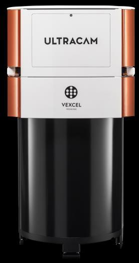
2 New Ownership Information: Vexcel Holdings GmbH, Graz, acquired Microsoft s UltraCam Business Unit in March 2016


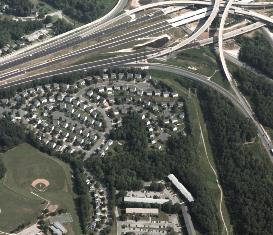
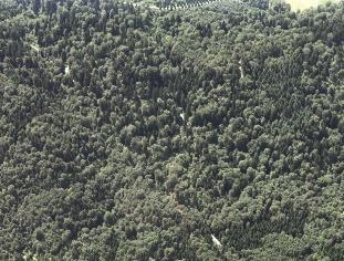
3 Exploring the world from every angle Aerial Cameras


4 New: UltraCam Eagle M3 26,460 x 17,004 pixel Favorable b/h ratio Outstanding signal/noise ratio Further improved frame rate Four exchangeable lens systems
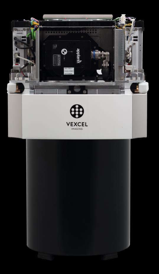
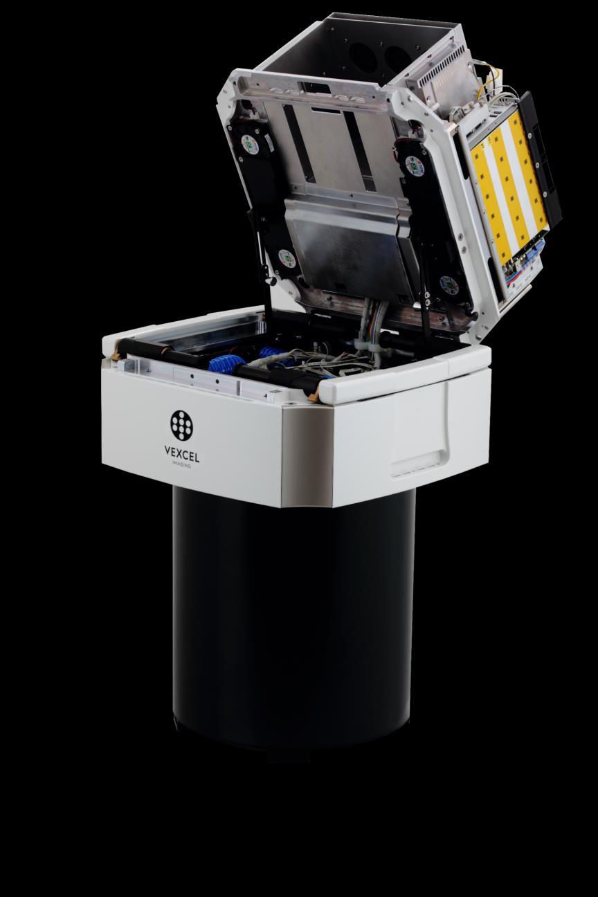

5 Highly Integrated System
6 UltraCam Eagle M3 PAN pixel across 26,460 PAN focal length 80, 100, 120, 210 mm PAN pixel along 17,004 b/h (f80, f100, f120, f210) 0.34; 0.27; 0.23; 0.13 Max. frame rate 1.5s AGL for 5cm GSD (f80, f100, f120, f210) 1,000 m; 1,250 m; 1,500 m; 2,625 m Pan-sharpening ratio 1:3 Lens system User exchangeable w/o recalibration FMC TDI (non mechanical)


7 UltraCam D UltraCam X UltraCam Xp Eagle M1 Eagle M2 Eagle M3 Falcon M1 Falcon M MPixel


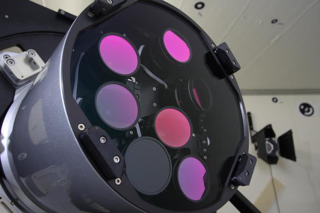
8 UltraCam Eagle M3 The UltraCam Eagle M3 features also the userexchangeable lens system 80 mm PAN 27 mm RGB & NIR 100 mm PAN 33 mm RGB & NIR 120 mm PAN 40 mm RGB & NIR 210 mm PAN 70 mm RGB & NIR

 Optimized")

9 UltraCam Osprey M3p Mapping grade nadir (pan, 116 Mpix) 80 Mpix oblique (4 directions) Optimized design 80mm nadir lens system 120mm oblique lens system
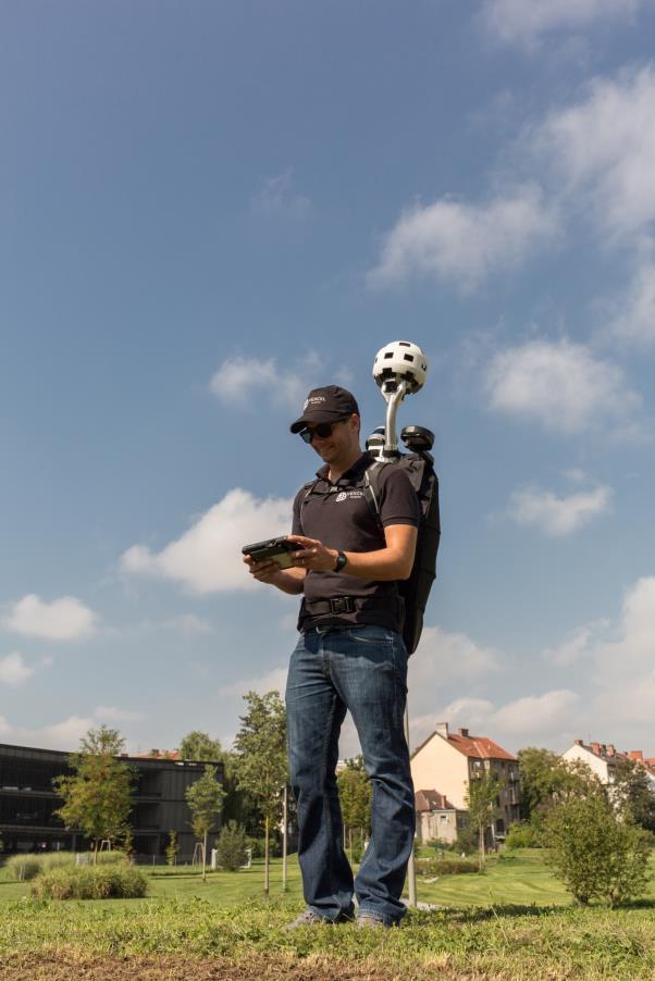
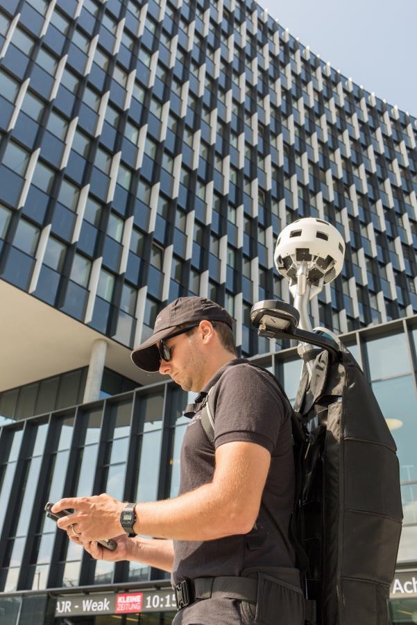
10 UltraCam Osprey M3p


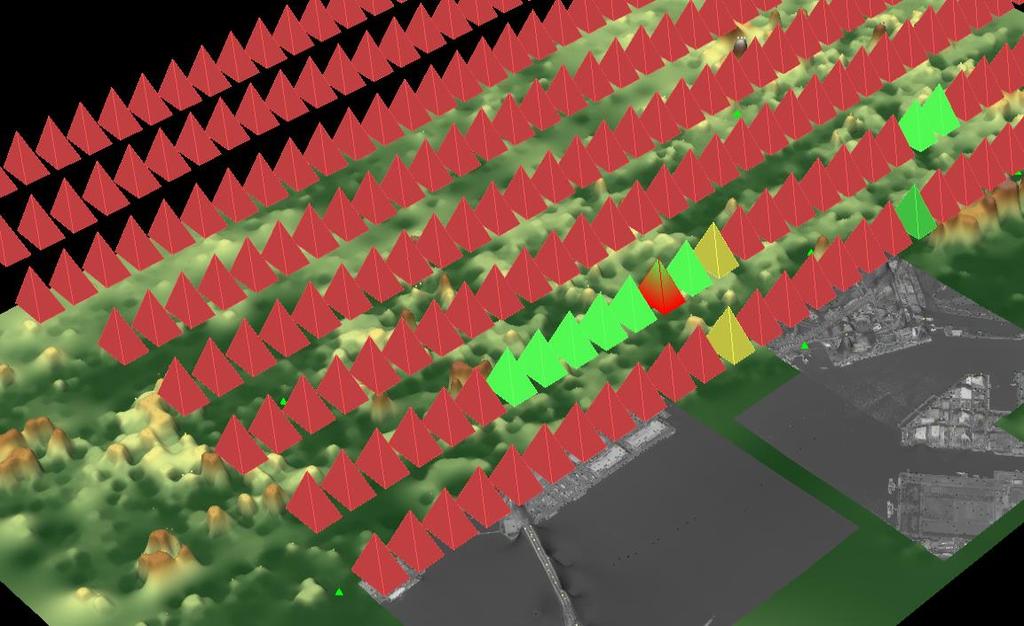
11 Oblique View 750 m GSD 5cm to 8 cm

12 UltraCam Condor M1

13 UltraCam Condor M1 Results RGB: by 5000 PAN: by 8650 NIR: 7600 by cm 28 cm

14 UltraCam Condor M1 Results 1200 by 800 pix 120 by 80 meter
15 UltraCam Condor M1 Design Criteria Designed to map large regions extremely efficient with UltraCam quality Highly efficient high-resolution RGB image collection for ortho image generation PAN of lower resolution supporting automated DTM and DSM generation for automated DSMOrtho and DTMOrtho image generation NIR of lower resolution supporting basic classification and DSM/DTM generation Typicall RGB GSD: 10cm 25cm Typicall flight altitude: 2,000m 5,500m AGL Characteristics Frame sensor for stable geometry and better independency from GPS/INS accuracy Uncompressed RAW data for leading image dynamic and color correction without artifacts FMC by TDI for fast flight speeds and high sensor reliability Sophisticated 16bit UltraMap workflow corrects color shift effects of high altitude flights automated and without artifacts Aicrafts: turboprop and jets
16 UltraCam Condor M1 Specifications Image size Physical pixel size Color (RGB Bayer pattern) 38,000 x 5,000 pixels 4.6 µm PAN 13,400 x 8,650 pixels 5.2 µm Color (NIR) 7,600 x 5,000 pixels 4.6 µm Color capability (multi-spectral) 4 channels RGB Bayer pattern & NIR Ratio RGB to PAN to NIR 1 : 2.83 : 4.35 Frame rate (minimum inter-image interval) 1 frame per 1.75 seconds Weight 64 kg Power consumption Max. 350 W Focal distance Lens aperture Color (RGB Bayer pattern) 100 mm f=1/5.6 PAN 40 mm F=1/4.8 Color (NIR) 23 mm F=1/5.6 Flying height for RGB pixel 10 cm GSD 2,174 m

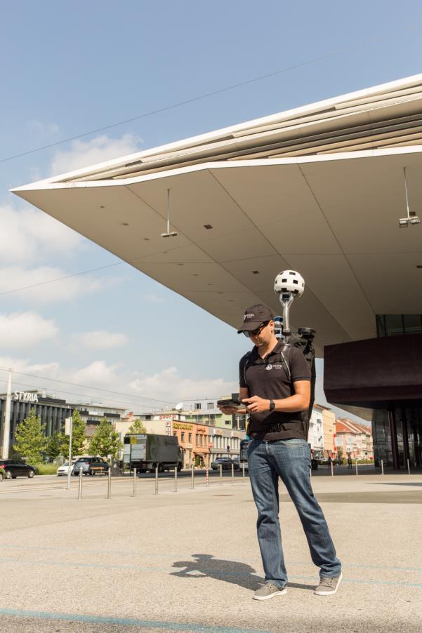
17 Terrestrial sensor systems
18 Mobile mapping system for capturing geo-positioned panoramic imagery and 3D data of street-level scenery Reliable partner on the road: Collected more than 5 million kilometers so far


19 Mobile mapping system for capturing geopositioned panoramic imagery and 3D data of street-level scenery Designed for maximum collection efficiency and minimum downtime In its 3 rd generation More than 200 systems fielded since 2007


20 360 Panoramic Imagery 54 Megapixels 8.0 mm high-resolution lenses Max. 8 frames per second

21 360 Panoramic Imagery

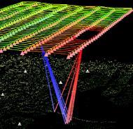
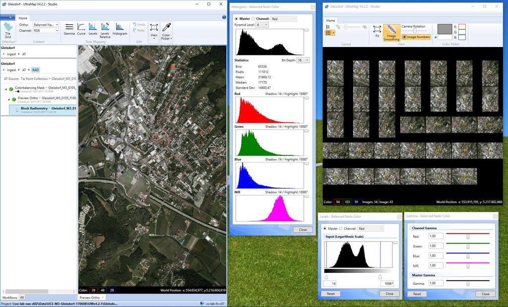
22 Dense LiDAR point clouds Rotating LiDAR with 32 laser beams points per second Dense 3D LiDAR point cloud creation

23 A9 from Graz A2 to Vienna Graz West A9/A2 Dense 3D LiDAR point cloud Color represent Elevation

24 Graz Webling Dense 3D LiDAR point cloud Color from UltraCam Panoramic Image Data

25 The UltraCam Panther enables your business to meet even the most demanding mobile mapping challenges: indoor, outdoor, everywhere! UltraCam Panther offers outstanding flexibility for mapping and virtual reality applications
26


27 Superior Image Quality Panoramic sensor head with 68.8 Mpixel (unique/stitched) 26 custom cameras Video frame rate max. 30 Hz Imagery frame rate max. 1 Hz 360 x 180 field of view 360-degree stitched Panorama Exceptionally high resolution Mpixel (gross)


28 Precise alignment of LiDAR & image data Rotating LiDAR with 16 laser beams pts/sec Dense 3D LiDAR point cloud creation Customizable LiDAR orientation to match different applications 3D geometry of the Landhaus in Graz 3D geometry for mobile mapping Spherical 3D LiDAR point cloud

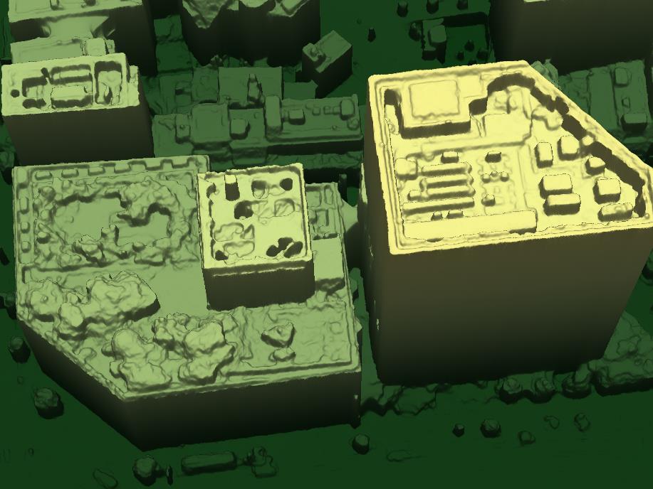
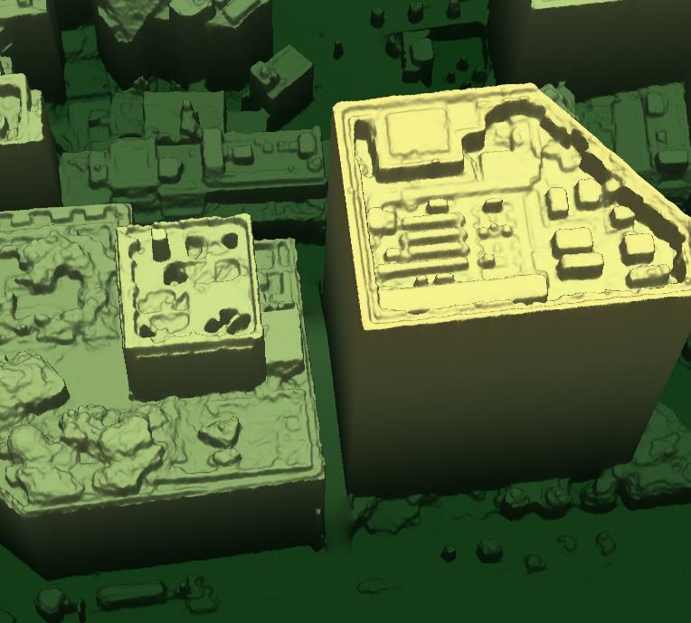
29 High quality panorama image pixel horizontal Object resolution 20m

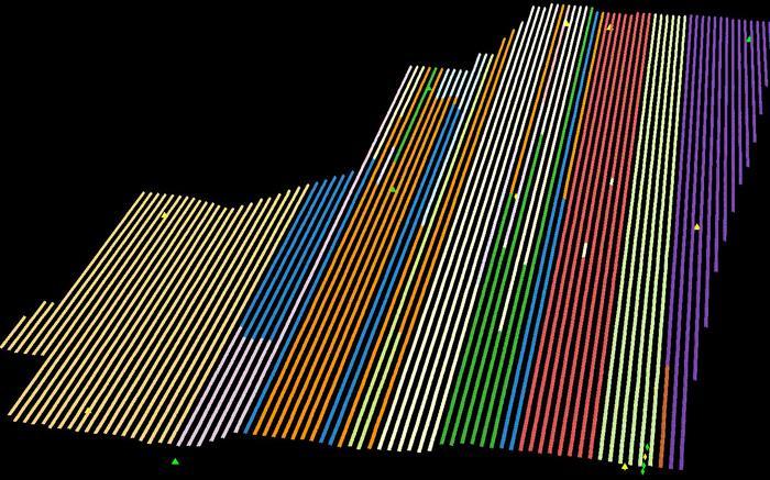
30 UltraMap V4 Digital Photogrammetric Workflow for Nadir and Oblique
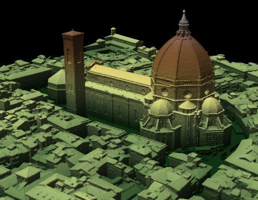
31 UltraMap V4 Digital Photogrammetric Workflow for Aerial and Terrestrial Application New intuitive GUI Oblique image processing and color balancing On the fly color adjustment 3D viewer UltraMap Terrestrial for UltraCam Mustang and Panther
32
33
34


35 Simultaneous nadir/oblique color balancing Raw Balanced


36 Powerful dehazing of nadir/oblique images


 3D Point")
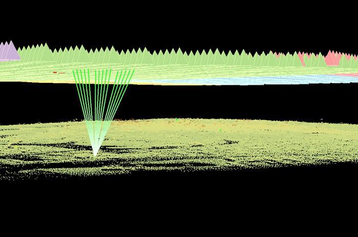
37 Automatic dense image matching Digital Surface Model (DSM) 3D Point Cloud (RGB, RGBI, CIR)
38

39 Precise 3D reconstruction: Point cloud, DSM/DTM, 3DTIN

40 Precise 3D reconstruction: 3DTIN

41 Precise 3D reconstruction: 3DTIN with undercuts
42
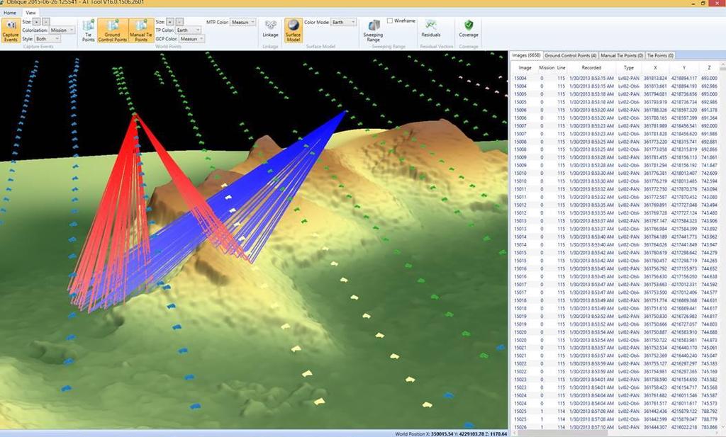
CALIBRATING THE NEW ULTRACAM OSPREY OBLIQUE AERIAL SENSOR Michael Gruber, Wolfgang Walcher
 CALIBRATING THE NEW ULTRACAM OSPREY OBLIQUE AERIAL SENSOR Michael Gruber, Wolfgang Walcher Microsoft UltraCam Business Unit Anzengrubergasse 8/4, 8010 Graz / Austria {michgrub, wwalcher}@microsoft.com
UltraCam and UltraMap An Update
 Photogrammetric Week '15 Dieter Fritsch (Ed.) Wichmann/VDE Verlag, Belin & Offenbach, 2015 Wiechert, Gruber 45 UltraCam and UltraMap An Update Alexander Wiechert, Michael Gruber, Graz ABSTRACT When UltraCam
UltraCam and UltraMap An Update
 Photogrammetric Week '13 Dieter Fritsch (Ed.) Wichmann/VDE Verlag, Belin & Offenbach, 2013 Wiechert 37 UltraCam and UltraMap An Update ALEXANDER WIECHERT, Graz ABSTRACT When UltraCam D was presented first
ULTRACAM EAGLE MARK 3. One system for endless possibilities
 ULTRACAM EAGLE MARK 3 One system for endless possibilities ULTRACAM EAGLE MARK 3 26,460 pixels across track An ultra-large footprint coupled with a unique user-exchangeable lens system makes the UltraCam
UltraCam and UltraMap Towards All in One Solution by Photogrammetry
 Photogrammetric Week '11 Dieter Fritsch (Ed.) Wichmann/VDE Verlag, Belin & Offenbach, 2011 Wiechert, Gruber 33 UltraCam and UltraMap Towards All in One Solution by Photogrammetry ALEXANDER WIECHERT, MICHAEL
Vexcel Imaging GmbH Innovating in Photogrammetry: UltraCamXp, UltraCamLp and UltraMap
 Photogrammetric Week '09 Dieter Fritsch (Ed.) Wichmann Verlag, Heidelberg, 2009 Wiechert, Gruber 27 Vexcel Imaging GmbH Innovating in Photogrammetry: UltraCamXp, UltraCamLp and UltraMap ALEXANDER WIECHERT,
UltraCam Eagle Prime Aerial Sensor Calibration and Validation
 UltraCam Eagle Prime Aerial Sensor Calibration and Validation Michael Gruber, Marc Muick Vexcel Imaging GmbH Anzengrubergasse 8/4, 8010 Graz / Austria {michael.gruber, marc.muick}@vexcel-imaging.com Key
NEWS FROM THE ULTRACAM CAMERA LINE-UP INTRODUCTION
 NEWS FROM THE ULTRACAM CAMERA LINE-UP Alexander Wiechert, Michael Gruber Vexcel Imaging Austria / Microsoft Photogrammetry Anzengrubergasse 8/4, 8010 Graz / Austria {alwieche, michgrub}@microsoft.com ABSTRACT
Phase One 190MP Aerial System
 White Paper Phase One 190MP Aerial System Introduction Phase One Industrial s 100MP medium format aerial camera systems have earned a worldwide reputation for its high performance. They are commonly used
Aerial Triangulation Radiometry Essentials Dense Matching Ortho Generation
 Radiometry Aerial Triangulation Essentials Dense Matching Ortho Generation Highly advanced photogrammetric workflow system for UltraCam images. Microsoft UltraMap is a state-of-the-art, end-to-end, complete
VisionMap Sensors and Processing Roadmap
 Vilan, Gozes 51 VisionMap Sensors and Processing Roadmap YARON VILAN, ADI GOZES, Tel-Aviv ABSTRACT The A3 is a family of digital aerial mapping cameras and photogrammetric processing systems, which is
Jens Kremer ISPRS Hannover Workshop 2017,
 Jens Kremer ISPRS Hannover Workshop 2017, 8.06.2017 Modular aerial camera-systems The IGI UrbanMapper 2-in1 concept System Layout The DigiCAM-100 module The IGI UrbanMapper Sensor geometry & stitching
HIGH RESOLUTION COLOR IMAGERY FOR ORTHOMAPS AND REMOTE SENSING. Author: Peter Fricker Director Product Management Image Sensors
 HIGH RESOLUTION COLOR IMAGERY FOR ORTHOMAPS AND REMOTE SENSING Author: Peter Fricker Director Product Management Image Sensors Co-Author: Tauno Saks Product Manager Airborne Data Acquisition Leica Geosystems
Calibration Report. UC-SXp Version of Report:
 Calibration Report Camera: Serial: UltraCam Xp UC-SXp-1-40719017 Calibration Date: Date of Report: Camera Revision: Version of Report: Feb-28-2018 Mar-05-2018 Rev13.00 V01 www.vexcel-imaging.com Copyright
Calibration Report. Short Version. UltraCam Eagle, S/N UC-E f210. Vexcel Imaging GmbH, A-8010 Graz, Austria
 Calibration Report Short Version Camera: Manufacturer: Date of Calibration: Date of Report: Revision of Camera: Version of Report: UltraCam Eagle, S/N UC-E-1-00518105-f210 Vexcel Imaging GmbH, A-8010 Graz,
Calibration Report. Short Version. UltraCam L, S/N UC-L Vexcel Imaging GmbH, A-8010 Graz, Austria
 Calibration Report Short Version Camera: Manufacturer: UltraCam L, S/N UC-L-1-00612089 Vexcel Imaging GmbH, A-8010 Graz, Austria Date of Calibration: Mar-23-2010 Date of Report: May-17-2010 Camera Revision:
Leica - 3 rd Generation Airborne Digital Sensors Features / Benefits for Remote Sensing & Environmental Applications
 Leica - 3 rd Generation Airborne Digital Sensors Features / Benefits for Remote Sensing & Environmental Applications Arthur Rohrbach, Sensor Sales Dir Europe, Middle-East and Africa (EMEA) Luzern, Switzerland,
ULTRACAMX AND A NEW WAY OF PHOTOGRAMMETRIC PROCESSING
 ULTRACAMX AND A NEW WAY OF PHOTOGRAMMETRIC PROCESSING Michael Gruber, Bernhard Reitinger Microsoft Photogrammetry Anzengrubergasse 8, A-8010 Graz, Austria {michgrub, bernreit}@microsoft.com ABSTRACT This
VisionMap A3 Edge A Single Camera for Multiple Solutions
 Photogrammetric Week '15 Dieter Fritsch (Ed.) Wichmann/VDE Verlag, Belin & Offenbach, 2015 Raizman, Gozes 57 VisionMap A3 Edge A Single Camera for Multiple Solutions Yuri Raizman, Adi Gozes, Tel-Aviv ABSTRACT
Nneirda - Fotolia.com
 www.iflyultracam.com Nneirda - Fotolia.com Why I fly UltraCam. www.iflyultracam.com "Exceptional price-to-performance ratio. That s why I fly UltraCam." ( Ken Potter, Keystone Aerial Surveys) To excel
Calibration Report. Short version. UltraCam Xp, S/N UC-SXp Vexcel Imaging GmbH, A-8010 Graz, Austria
 Calibration Report Short version Camera: Manufacturer: UltraCam Xp, S/N UC-SXp-1-61212452 Vexcel Imaging GmbH, A-8010 Graz, Austria Date of Calibration: Mar-05-2009 Date of Report: Mar-13-2009 Camera Revision:
Calibration Report. Short version. UltraCam X, S/N UCX-SX Microsoft Photogrammetry, A-8010 Graz, Austria. ( 1 of 13 )
") Calibration Report Short version Camera: Manufacturer: UltraCam X, S/N UCX-SX-1-30518177 Microsoft Photogrammetry, A-8010 Graz, Austria Date of Calibration: May-24-2007 Date of Report: Jun-21-2007 Camera
Calibration Report Short version Camera: Manufacturer: UltraCam X, S/N UCX-SX-1-30518177 Microsoft Photogrammetry, A-8010 Graz, Austria Date of Calibration: May-24-2007 Date of Report: Jun-21-2007 Camera
Ground Control Configuration Analysis for Small Area UAV Imagery Based Mapping
 Ground Control Configuration Analysis for Small Area UAV Imagery Based Mapping ASPRS IGTF 2017, Baltimore, MD March 15 th, 2017 Presenter: David Day, CP, GISP Wes Weaver Keystone Aerial Surveys, Inc. Summary
Calibration Report. Short Version. Vexcel Imaging GmbH, A-8010 Graz, Austria
 Calibration Report Short Version Camera: Manufacturer: UltraCam D, S/N UCD-SU-2-0039 Vexcel Imaging GmbH, A-8010 Graz, Austria Date of Calibration: Mar-14-2011 Date of Report: Mar-17-2011 Camera Revision:
PROPERTY OF THE LARGE FORMAT DIGITAL AERIAL CAMERA DMC II
 PROPERTY OF THE LARGE FORMAT DIGITAL AERIAL CAMERA II K. Jacobsen a, K. Neumann b a Institute of Photogrammetry and GeoInformation, Leibniz University Hannover, Germany jacobsen@ipi.uni-hannover.de b Z/I
Leica ADS80 - Digital Airborne Imaging Solution NAIP, Salt Lake City 4 December 2008
 Luzern, Switzerland, acquired at 5 cm GSD, 2008. Leica ADS80 - Digital Airborne Imaging Solution NAIP, Salt Lake City 4 December 2008 Shawn Slade, Doug Flint and Ruedi Wagner Leica Geosystems AG, Airborne
Calibration Report. UltraCam Eagle, S/N UC-Eagle f80. Vexcel Imaging GmbH, A-8010 Graz, Austria
 Calibration Report Camera: Manufacturer: UltraCam Eagle, S/N UC-Eagle-1-60411397-f80 Vexcel Imaging GmbH, A-8010 Graz, Austria Date of Calibration: Jul-23-2013 Date of Report: Aug-06-2013 Camera Revision:
Five Sensors, One Day: Unmanned vs. Manned Logistics and Accuracy
 Five Sensors, One Day: Unmanned vs. Manned Logistics and Accuracy ASPRS UAS Mapping Technical Symposium Sept 13 th, 2016 Presenter: David Day, CP, GISP Keystone Aerial Surveys, Inc. Summary of activities
TELLS THE NUMBER OF PIXELS THE TRUTH? EFFECTIVE RESOLUTION OF LARGE SIZE DIGITAL FRAME CAMERAS
 TELLS THE NUMBER OF PIXELS THE TRUTH? EFFECTIVE RESOLUTION OF LARGE SIZE DIGITAL FRAME CAMERAS Karsten Jacobsen Leibniz University Hannover Nienburger Str. 1 D-30167 Hannover, Germany jacobsen@ipi.uni-hannover.de
RPAS Photogrammetric Mapping Workflow and Accuracy
 RPAS Photogrammetric Mapping Workflow and Accuracy Dr Yincai Zhou & Dr Craig Roberts Surveying and Geospatial Engineering School of Civil and Environmental Engineering, UNSW Background RPAS category and
While film cameras still
 aerial perspective by Mathias Lemmens, editor-in-chief, GIM International Digital Aerial Cameras System Configurations and Sensor Architectures Editor s note: This issue includes an extensive product survey
Monitoring the vegetation success of a rehabilitated mine site using multispectral UAV imagery. Tim Whiteside & Renée Bartolo, eriss
 Monitoring the vegetation success of a rehabilitated mine site using multispectral UAV imagery Tim Whiteside & Renée Bartolo, eriss About the Supervising Scientist Main roles Working to protect the environment
MEDIUM FORMAT CAMERA EVALUATION BASED ON THE LATEST PHASE ONE TECHNOLOGY
 MEDIUM FORMAT CAMERA EVALUATION BASED ON THE LATEST PHASE ONE TECHNOLOGY T.Tölg a, G. Kemper b, D. Kalinski c a Phase One / Germany tto@phaseone.com b GGS GmbH, Speyer / Germany kemper@ggs-speyer.de c
Airborne or Spaceborne Images for Topographic Mapping?
 Advances in Geosciences Konstantinos Perakis, Editor EARSeL, 2012 Airborne or Spaceborne Images for Topographic Mapping? Karsten Jacobsen Leibniz University Hannover, Institute of Photogrammetry and Geoinformation,
LECTURE NOTES 2016 CONTENTS. Sensors and Platforms for Acquisition of Aerial and Satellite Image Data
 LECTURE NOTES 2016 Prof. John TRINDER School of Civil and Environmental Engineering Telephone: (02) 9 385 5020 Fax: (02) 9 313 7493 j.trinder@unsw.edu.au CONTENTS Chapter 1 Chapter 2 Sensors and Platforms
DEM Generation Using a Digital Large Format Frame Camera
 DEM Generation Using a Digital Large Format Frame Camera Joachim Höhle Abstract Progress in automated photogrammetric DEM generation is presented. Starting from the procedures and the performance parameters
ABOUT FRAME VERSUS PUSH-BROOM AERIAL CAMERAS
 ABOUT FRAME VERSUS PUSH-BROOM AERIAL CAMERAS Franz Leberl and Michael Gruber Microsoft Photogrammetry, 8010 Graz ABSTRACT When presenting digital large format aerial cameras to the interested community
Geometry of Aerial Photographs
 Geometry of Aerial Photographs Aerial Cameras Aerial cameras must be (details in lectures): Geometrically stable Have fast and efficient shutters Have high geometric and optical quality lenses They can
Calibration Report. Vexcel Imaging GmbH, A-8010 Graz, Austria
 Calibration Report Camera: Manufacturer: UltraCam D, S/N UCD-SU-1-0031 Vexcel Imaging GmbH, A-8010 Graz, Austria Date of Calibration: Apr-10-2009 Date of Report: Feb-15-2010 Camera Revision: 4.0 Revision
Planet Labs Inc 2017 Page 2
 SKYSAT IMAGERY PRODUCT SPECIFICATION: ORTHO SCENE LAST UPDATED JUNE 2017 SALES@PLANET.COM PLANET.COM Disclaimer This document is designed as a general guideline for customers interested in acquiring Planet
[NAIP, 2009]. That. 2011, Global Ortho
![[NAIP, 2009]. That. 2011, Global Ortho](/thumbs/95/124863156.jpg "[NAIP, 2009]. That. 2011, Global Ortho") The Microsoft Global Ortho Program Wolfgang Walcher a, Franz Leberl b, Michael Gruber c a Microsoft Bing Imagery Technologies, 1500 Pearl Street, Boulder, Colorado, wwalcher@ @microsoft.comm b Graz University
The Microsoft Global Ortho Program Wolfgang Walcher a, Franz Leberl b, Michael Gruber c a Microsoft Bing Imagery Technologies, 1500 Pearl Street, Boulder, Colorado, wwalcher@ @microsoft.comm b Graz University
Digital airborne cameras Status & future
 Institut für Photogrammetrie ifp Digital airborne cameras Status & future Michael Cramer Institute for Photogrammetry, Univ. of Stuttgart Geschwister-Scholl-Str.24, D-70174 Stuttgart Tel: + 49 711 121
Digital Aerial Photography UNBC March 22, Presented by: Dick Mynen TDB Consultants Inc.
 Digital Aerial Photography UNBC March 22, 2011 Presented by: Dick Mynen TDB Consultants Inc. Airborne Large Scale Digital Photography Who is using the technology in today s environment Options available
POTENTIAL OF LARGE FORMAT DIGITAL AERIAL CAMERAS. Dr. Karsten Jacobsen Leibniz University Hannover, Germany
 POTENTIAL OF LARGE FORMAT DIGITAL AERIAL CAMERAS Dr. Karsten Jacobsen Leibniz University Hannover, Germany jacobsen@ipi.uni-hannover.de Introduction: Digital aerial cameras are replacing traditional analogue
EXAMPLES OF TOPOGRAPHIC MAPS PRODUCED FROM SPACE AND ACHIEVED ACCURACY CARAVAN Workshop on Mapping from Space, Phnom Penh, June 2000
 EXAMPLES OF TOPOGRAPHIC MAPS PRODUCED FROM SPACE AND ACHIEVED ACCURACY CARAVAN Workshop on Mapping from Space, Phnom Penh, June 2000 Jacobsen, Karsten University of Hannover Email: karsten@ipi.uni-hannover.de
Geometry perfect Radiometry unknown?
 Institut für Photogrammetrie Geometry perfect Radiometry unknown? Photogrammetric Week 2011 Stuttgart Michael Cramer Institut für Photogrammetrie () Universität Stuttgart michael.cramer@.uni-stuttgart.de
IGI Ltd. Serving the Aerial Survey Industry for more than 20 Years
 'Photogrammetric Week 05' Dieter Fritsch, Ed. Wichmann Verlag, Heidelberg 2005. Kremer 33 IGI Ltd. Serving the Aerial Survey Industry for more than 20 Years JENS KREMER, Kreuztal ABSTRACT Since 1982 IGI
Aerial efficiency, photogrammetric accuracy
 Aerial efficiency, photogrammetric accuracy Why sensefly 3 reasons to choose the ebee Plus Large coverage for optimal efficiency The ebee Plus can map more square kilometres per flight, than any drone
Adding Depth. Introduction. PTViewer3D. Helmut Dersch. May 20, 2016
 Adding Depth Helmut Dersch May 20, 2016 Introduction It has long been one of my goals to add some kind of 3d-capability to panorama viewers. The conventional technology displays a stereoscopic view based
EnsoMOSAIC Aerial mapping tools
 EnsoMOSAIC Aerial mapping tools Jakarta and Kuala Lumpur, 2013 Contents MosaicMill MM Application examples Software introduction System introduction Rikola HS sensor UAV platform examples SW Syst HS UAV
Geo-localization and Mosaicing System (GEMS): Enabling Precision Image Feature Location and Rapid Mosaicing General:
: Enabling Precision Image Feature Location and Rapid Mosaicing General:") Geo-localization and Mosaicing System (GEMS): Enabling Precision Image Feature Location and Rapid Mosaicing General: info@senteksystems.com www.senteksystems.com 12/6/2014 Precision Agriculture Multi-Spectral
Geo-localization and Mosaicing System (GEMS): Enabling Precision Image Feature Location and Rapid Mosaicing General: info@senteksystems.com www.senteksystems.com 12/6/2014 Precision Agriculture Multi-Spectral
MEDIUM FORMAT DIGITAL CAMERAS - A EUROSDR PROJECT
 MEDIUM FORMAT DIGITAL CAMERAS - A EUROSDR PROJECT G. J. Grenzdörffer a a Rostock University, Chair of Geodesy and Geoinformatics, J.-v.-Liebig Weg 6, 18059 Rostock, Germany-(goerres.grenzdoerffer)@uni-rostock.de
Consumer digital CCD cameras
 CAMERAS Consumer digital CCD cameras Leica RC-30 Aerial Cameras Zeiss RMK Zeiss RMK in aircraft Vexcel UltraCam Digital (note multiple apertures Lenses for Leica RC-30. Many elements needed to minimize
Phase One ixu-rs1000 Accuracy Assessment Report Yu. Raizman, PhaseOne.Industrial, Israel
 17 th International Scientific and Technical Conference FROM IMAGERY TO DIGITAL REALITY: ERS & Photogrammetry Phase One ixu-rs1000 Accuracy Assessment Report Yu. Raizman, PhaseOne.Industrial, Israel 1.
Section 2 Image quality, radiometric analysis, preprocessing
 Section 2 Image quality, radiometric analysis, preprocessing Emmanuel Baltsavias Radiometric Quality (refers mostly to Ikonos) Preprocessing by Space Imaging (similar by other firms too): Modulation Transfer
E m e r g e n c y M a n a g e m e n t S e r v i c e. C o p e r n i c u s A e r i a l c o m p o n e n t s t a t u s s t u d y
 E m e r g e n c y M a n a g e m e n t S e r v i c e C o p e r n i c u s A e r i a l c o m p o n e n t s t a t u s s t u d y Peter Spruyt European Commission Joint Research Centre EMS Mapping User Workshop
UAV PHOTOGRAMMETRY COMPARED TO TRADITIONAL RTK GPS SURVEYING
 UAV PHOTOGRAMMETRY COMPARED TO TRADITIONAL RTK GPS SURVEYING Brad C. Mathison and Amber Warlick March 20, 2016 Fearless Eye Inc. Kansas City, Missouri www.fearlesseye.com KEY WORDS: UAV, UAS, Accuracy
Camera Calibration Certificate No: DMC IIe
 Calibration DMC IIe 230 23522 Camera Calibration Certificate No: DMC IIe 230 23522 For Richard Crouse & Associates 467 Aviation Way Frederick, MD 21701 USA Calib_DMCIIe230-23522.docx Document Version 3.0
CALIBRATION REPORT SUMMARY
 CALIBRATION REPORT SUMMARY Material Description Assembly 2PADI080 1027 0997 A / 09A Camera Module 1 CCD KODAK KAF 39Mp Full Frame Color Image Sensor SN CQ011027 Lens Schneider Apo Digitar 4.0/80 N SN 15006871
VERIFICATION OF POTENCY OF AERIAL DIGITAL OBLIQUE CAMERAS FOR AERIAL PHOTOGRAMMETRY IN JAPAN
 VERIFICATION OF POTENCY OF AERIAL DIGITAL OBLIQUE CAMERAS FOR AERIAL PHOTOGRAMMETRY IN JAPAN Ryuji. Nakada a, *, Masanori. Takigawa a, Tomowo. Ohga a, Noritsuna. Fujii a a Asia Air Survey Co. Ltd., Kawasaki
IGI mbh - 40 years celebration
 ntegrated eospatial nnovations IGI mbh - 40 years celebration Founded 1978 More than 500 customers in 84 different countries World-wide technical support IGI office in Kreuztal, Germany 3 Open Skies Area
PLANET IMAGERY PRODUCT SPECIFICATIONS PLANET.COM
 PLANET IMAGERY PRODUCT SPECIFICATIONS SUPPORT@PLANET.COM PLANET.COM LAST UPDATED JANUARY 2018 TABLE OF CONTENTS LIST OF FIGURES 3 LIST OF TABLES 4 GLOSSARY 5 1. OVERVIEW OF DOCUMENT 7 1.1 Company Overview
NEW. Airborne Laser Scanning. Dual Wavelength Waveform Processing Airborne LiDAR Scanning System for High-Point Density Mapping Applications
 Dual Wavelength Waveform Processing Airborne LiDAR Scanning System for High-Point Density Mapping Applications NEW RIEGL VQ-156i-DW enhanced target characterization based upon simultaneous measurements
Processing of stereo scanner: from stereo plotter to pixel factory
 Photogrammetric Week '03 Dieter Fritsch (Ed.) Wichmann Verlag, Heidelberg, 2003 Bignone 141 Processing of stereo scanner: from stereo plotter to pixel factory FRANK BIGNONE, ISTAR, France ABSTRACT With
Dual Channel Waveform Processing Airborne LiDAR Scanning System for High-Point Density and Ultra-Wide Area Mapping
 Dual Channel Waveform Processing Airborne LiDAR Scanning System for High-Point Density and Ultra-Wide Area Mapping RIEGL VQ-156i high laser pulse repetition rate up to 2 MHz up to 1.33 million measurements
Camera Calibration Certificate No: DMC II
 Calibration DMC II 140-036 Camera Calibration Certificate No: DMC II 140-036 For Midwest Aerial Photography 7535 West Broad St, Galloway, OH 43119 USA Calib_DMCII140-036.docx Document Version 3.0 page
MSB Imagery Program FAQ v1
 MSB Imagery Program FAQ v1 (F)requently (A)sked (Q)uestions 9/22/2016 This document is intended to answer commonly asked questions related to the MSB Recurring Aerial Imagery Program. Table of Contents
Camera Calibration Certificate No: DMC II
 Calibration DMC II 230 015 Camera Calibration Certificate No: DMC II 230 015 For Air Photographics, Inc. 2115 Kelly Island Road MARTINSBURG WV 25405 USA Calib_DMCII230-015_2014.docx Document Version 3.0
Camera Calibration Certificate No: DMC II
 Calibration DMC II 140-005 Camera Calibration Certificate No: DMC II 140-005 For Midwest Aerial Photography 7535 West Broad St, Galloway, OH 43119 USA Calib_DMCII140-005.docx Document Version 3.0 page
Overview. Objectives. The ultimate goal is to compare the performance that different equipment offers us in a photogrammetric flight.
 Overview At present, one of the most commonly used technique for topographic surveys is aerial photogrammetry. This technique uses aerial images to determine the geometric properties of objects and spatial
Camera Calibration Certificate No: DMC II
 Calibration DMC II 230 027 Camera Calibration Certificate No: DMC II 230 027 For Peregrine Aerial Surveys, Inc. 103-20200 56 th Ave Langley, BC V3A 8S1 Canada Calib_DMCII230-027.docx Document Version 3.0
Dual Channel Waveform Processing Airborne LiDAR Scanning System for High Point Density and Ultra Wide Area Mapping
 Dual Channel Waveform Processing Airborne LiDAR Scanning System for High Point Density and Ultra Wide Area Mapping RIEGL VQ-156i high laser pulse repetition rate: up to 2 MHz up to 1.33 million measurements
Camera Calibration Certificate No: DMC II Aero Photo Europe Investigation
 Calibration DMC II 250 030 Camera Calibration Certificate No: DMC II 250 030 For Aero Photo Europe Investigation Aerodrome de Moulins Montbeugny Yzeure Cedex 03401 France Calib_DMCII250-030.docx Document
Baldwin and Mobile Counties, AL Orthoimagery Project Report. Submitted: March 23, 2016
 2015 Orthoimagery Project Report Submitted: Prepared by: Quantum Spatial, Inc 523 Wellington Way, Suite 375 Lexington, KY 40503 859-277-8700 Page i of iii Contents Project Report 1. Summary / Scope...
Camera Calibration Certificate No: DMC II
 Calibration DMC II 230 020 Camera Calibration Certificate No: DMC II 230 020 For MGGP Aero Sp. z o.o. ul. Słowackiego 33-37 33-100 Tarnów Poland Calib_DMCII230-020.docx Document Version 3.0 page 1 of 40
High Resolution Sensor Test Comparison with SPOT, KFA1000, KVR1000, IRS-1C and DPA in Lower Saxony
 High Resolution Sensor Test Comparison with SPOT, KFA1000, KVR1000, IRS-1C and DPA in Lower Saxony K. Jacobsen, G. Konecny, H. Wegmann Abstract The Institute for Photogrammetry and Engineering Surveys
UAS Photogrammetry Best Practices
 UAS Photogrammetry Best Practices Pennsylvania Society of Land Surveyors January 15, 2019 Bryan Baker Certified Mapping Scientist (UAS) Bryan Baker UAS Sales Manager Leica Geosystems Reality Capture Team
Introduction to Photogrammetry
 Introduction to Photogrammetry Presented By: Sasanka Madawalagama Geoinformatics Center Asian Institute of Technology Thailand www.geoinfo.ait.asia Content Introduction to photogrammetry 2D to 3D Drones
LPIS Orthoimagery An assessment of the Bing imagery for LPIS purpose
 LPIS Orthoimagery An assessment of the Bing imagery for LPIS purpose Slavko Lemajić Wim Devos, Pavel Milenov GeoCAP Action - MARS Unit - JRC Ispra Tallinn, 24 th November 2011 Outline JRC`s Ortho specifications
Image Fusion. Pan Sharpening. Pan Sharpening. Pan Sharpening: ENVI. Multi-spectral and PAN. Magsud Mehdiyev Geoinfomatics Center, AIT
 1 Image Fusion Sensor Merging Magsud Mehdiyev Geoinfomatics Center, AIT Image Fusion is a combination of two or more different images to form a new image by using certain algorithms. ( Pohl et al 1998)
RECENT DEVELOPMENTS OF DIGITAL CAMERAS AND SPACE IMAGERY. Karsten JACOBSEN
 RECENT DEVELOPMENTS OF DIGITAL CAMERAS AND SPACE IMAGERY Abstract Karsten JACOBSEN Leibniz University Hannover, Institute of Photogrammetry and Geoinformation, Nienburger Str. 1, D-30167 Hannover, Germany
Full Waveform Digitizing, Dual Channel Airborne LiDAR Scanning System for Ultra Wide Area Mapping
 Full Waveform Digitizing, Dual Channel Airborne LiDAR Scanning System for Ultra Wide Area Mapping RIEGL LMS-Q56 high laser pulse repetition rate up to 8 khz digitization electronics for full waveform data
Experimental aerial photogrammetry with professional non metric camera Canon EOS 5D
 Experimental aerial photogrammetry with professional non metric camera Canon EOS 5D Ante Sladojević, Goran Mrvoš Galileo Geo Sustavi, Croatia 1. Introduction With this project we wanted to test professional
Aerial photography: Principles. Frame capture sensors: Analog film and digital cameras
 Aerial photography: Principles Frame capture sensors: Analog film and digital cameras Overview Introduction Frame vs scanning sensors Cameras (film and digital) Photogrammetry Orthophotos Air photos are
From Photos to Models
 From Photos to Models Strategies for using digital photogrammetry in your project Adam Barnes Katie Simon Adam Wiewel What is Photogrammetry? The art, science and technology of obtaining reliable information
Sample Copy. Not For Distribution.
 Photogrammetry, GIS & Remote Sensing Quick Reference Book i EDUCREATION PUBLISHING Shubham Vihar, Mangla, Bilaspur, Chhattisgarh - 495001 Website: www.educreation.in Copyright, 2017, S.S. Manugula, V.
UAV Technologies for 3D Mapping. Rolf Schaeppi Director Geospatial Solutions APAC / India
 UAV Technologies for 3D Mapping Rolf Schaeppi Director Geospatial Solutions APAC / India Some main application areas? Market situation Analyst statements billion dollars 7,3 defense market 2,5 civil market
Lecture 19: Depth Cameras. Kayvon Fatahalian CMU : Graphics and Imaging Architectures (Fall 2011)
") Lecture 19: Depth Cameras Kayvon Fatahalian CMU 15-869: Graphics and Imaging Architectures (Fall 2011) Continuing theme: computational photography Cheap cameras capture light, extensive processing produces
Lecture 19: Depth Cameras Kayvon Fatahalian CMU 15-869: Graphics and Imaging Architectures (Fall 2011) Continuing theme: computational photography Cheap cameras capture light, extensive processing produces
DigitalGlobe High Resolution Satellite Imagery
 DigitalGlobe High Resolution Satellite Imagery KIAN KANG, SALES MANAGER, SOUTH EAST ASIA & TAIWAN See a better world. DigitalGlobe Overview Over 1,300 employees spanning the globe H E A D Q UA R T E R
GEO 428: DEMs from GPS, Imagery, & Lidar Tuesday, September 11
 GEO 428: DEMs from GPS, Imagery, & Lidar Tuesday, September 11 Global Positioning Systems GPS is a technology that provides Location coordinates Elevation For any location with a decent view of the sky
INSTRUMENT DESIGN FOR THE PEGASUS HALE UAV PAYLOAD T. Van Achteren, B. Delauré, J. Everaerts
 INSTRUMENT DESIGN FOR THE PEGASUS HALE UAV PAYLOAD T. Van Achteren, B. Delauré, J. Everaerts Flemish Institute for Technological Research (VITO) Centre for Remote Sensing and Earth Observation (TAP) Boeretang
EVALUATION OF PLEIADES-1A TRIPLET ON TRENTO TESTFIELD
 EVALUATION OF PLEIADES-1A TRIPLET ON TRENTO TESTFIELD D. Poli a, F. Remondino b, E. Angiuli c, G. Agugiaro b a Terra Messflug GmbH, Austria b 3D Optical Metrology Unit, Fondazione Bruno Kessler, Trento,
Product Introduction
 Product Introduction 02-2015 With 71 Megapixel on 31 x 22mm, MICROBOX K71 sets new standards in camera design. Recent innovative developments in CMOS-technology now allows extremely high resolving shots
Tutorial 10 Information extraction from high resolution optical satellite sensors
 Tutorial 10 Information extraction from high resolution optical satellite sensors Karsten Jacobsen 1, Emmanuel Baltsavias 2, David Holland 3 1 University of, ienburger Strasse 1, D-30167, Germany, jacobsen@ipi.uni-hannover.de
HIGH RESOLUTION IMAGERY FOR MAPPING AND LANDSCAPE MONITORING
 HIGH RESOLUTION IMAGERY FOR MAPPING AND LANDSCAPE MONITORING Karsten Jacobsen Leibniz University Hannover, Institute of Photogrammetry and Geoinformation Nienburger Str. 1, 30165 Hannover, Germany, jacobsen@ipi.uni-hannover.de
Collection and application of 2D and 3D panoramic imagery
 Collection and application of 2D and 3D panoramic imagery CycloMedia Technology Bart Beers Stuttgart - September 9, 2011 Collection and application of 2D and 3D panoramic imagery Introduction CycloMedia
TESTFIELD TRENTO: GEOMETRIC EVALUATION OF VERY HIGH RESOLUTION SATELLITE IMAGERY
 TESTFIELD TRENTO: GEOMETRIC EVALUATION OF VERY HIGH RESOLUTION SATELLITE IMAGERY G. AGUGIAROa, D. POLIb, F. REMONDINOa, 3DOM, 3D Optical Metrology Unit Bruno Kessler Foundation, Trento, Italy a b Vermessung
Exam 4. Name: Class: Date: Multiple Choice Identify the choice that best completes the statement or answers the question.
 Name: Class: Date: Exam 4 Multiple Choice Identify the choice that best completes the statement or answers the question. 1. Mirages are a result of which physical phenomena a. interference c. reflection
Calibration Certificate
 Calibration Certificate Digital Mapping Camera (DMC) DMC Serial Number: DMC01-0053 CBU Serial Number: 0100053 For MPPG AERO Sp. z. o. o., ul. Kaczkowskiego 6 33-100 Tarnow Poland System Overview Flight
Camera Calibration Certificate No: DMC III 27542
 Calibration DMC III Camera Calibration Certificate No: DMC III 27542 For Peregrine Aerial Surveys, Inc. #201 1255 Townline Road Abbotsford, B.C. V2T 6E1 Canada Calib_DMCIII_27542.docx Document Version