Dual Channel Waveform Processing Airborne LiDAR Scanning System for High-Point Density and Ultra-Wide Area Mapping
|
|
|
- Cameron Marshall
- 5 years ago
- Views:
Transcription


1 Dual Channel Waveform Processing Airborne LiDAR Scanning System for High-Point Density and Ultra-Wide Area Mapping RIEGL VQ-156i high laser pulse repetition rate up to 2 MHz up to 1.33 million measurements per second on the ground offers data acquisition at a wide range of point densities two waveform processing LiDAR channels offering excellent multiple target detection capability enables Multiple-Time-Around (MTA) processing of up to 2 pulses simultaneously in the air offers online waveform processing as well as smart and full waveform recording integrated inertial measurement unit and GNSS receiver integrated, easily accessible medium format camera prepared for integration of a secondary camera high-speed fiber data interface to RIEGL data recorder housing shape and mounting flange optimized for interfacing with typical hatches and stabilized iz platforms detachable handgrips for facilitated handling ng The new ultra-high performance, fully integrated and calibrated Dual Channel Airborne Mapping System RIEGL VQ-156i makes use of RIEGL s sophisticated Waveform-LiDAR technology enabling an excellent multiple-target detection capability and Multiple-Time-Around (MTA) processing. The system is capable of online waveform processing as well as full or smart waveform recording, resulting in unsurpassed information content on each single target. The new VQ-156i provides a laser pulse repetition rate of up to 2 MHz resulting in more than 1.3 million measurements per second on the ground and operates at an altitude of up to 15,5 ft. That allows operation at varying flight altitudes resulting in a wide range of point densities. Thus, the system is ideally suited for aerial survey of ultrawide areas as well as of complex urban environments. By the way, faster and more efficient flight planning and safer flights are enabled. The RIEGL VQ-156i comes with a unique and innovative forward/ backward scan angle. This enables capturing data from multiple angles more effectively and more accurately at a high point density. With its large field of view of 58 degrees and its widely variable scan parameters the system enables highly efficient scan data acquisition. The system is equipped with a seamlessly integrated high performance IMU/GNSS unit and an optional 1 megapixel RGB camera as well as another camera, e.g. a thermal camera or a 1 megapixels near-infrared camera. All individual components are integrated into a compact housing, featuring a mounting flange for interfacing typical hatches or gyro-stabilized leveling mounts. Applications: Ultra Wide Area / High Altitude Mapping High Point Density Mapping Mapping of Complex Urban Environments Glacier & Snowfield Mapping City Modeling Mapping of Lakesides & River Banks Agriculture & Forestry Corridor Mapping visit our website Airborne Laser Scanning


2 RIEGL VQ-156i Scan Pattern effective FOV 28 Each channel delivers straight parallel scan lines. The scan lines of the two channels are tilted against each other by 28 degrees providing an optimum distribution of the measurements on the ground invariant to changes in terrain height. Tilt Angle of Scan Lines ± 14 Forward/Backward Scan Angle in Non-Nadir Direction ± 8 at the edge RIEGL VQ-156i Elements of Function and Operation mounting flange aperture of primary camera (RGB) aperture of laser channel #2 IMU bay aperture of laser channel #1 aperture of secondary camera connectors for power supply and data interface desiccant cartridges cooling air outlets carrying handles 2 Copyright RIEGL Laser Measurement Systems GmbH 217 All rights reserved.

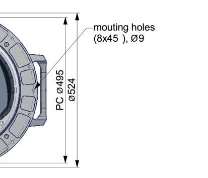
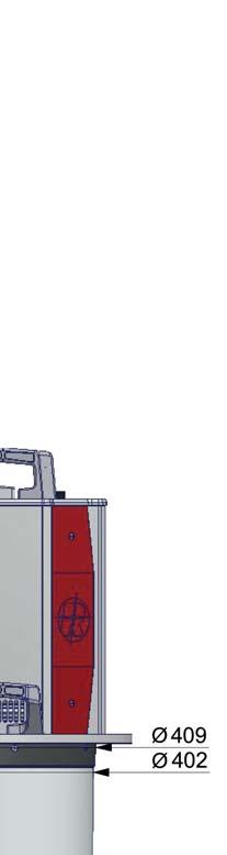


3 RIEGL VQ-156i Main Dimensions all dimensions in mm Copyright RIEGL Laser Measurement Systems GmbH 217 All rights reserved. 3


 operator working station A")


4 RIEGL VQ-156i System Components GNSS antenna USB 3. interface high speed interface LAN interface - flight guidance LAN interface - system control laser safety switch RIEGL VQ-156i control for gyro-stabilized mount laser safety switch RIEGL DR156(i) FOTO pilot display flight guidance ix- Controller (optional) gyro-stabilized mount GSM-4 (optional) operator working station A minimum number of system components and external cabling is required for an easy and quick installation in aircrafts. RIEGL VQ-156i Installation Examples RIEGL VQ-156i installed in the nose pod of fixed-wing aircraft DA42 MPP RIEGL VQ-156i installed on GSM-4 gyro-stabilized platform to be used in a helicopter or fixed-wing aircraft 4 Copyright RIEGL Laser Measurement Systems GmbH 217 All rights reserved.
5 Measurement Range & Point Density RIEGL VQ-156i PRR = 2x15 khz, laser power level 1% visibility 4 km ft (177 m) 198 m 74 ft (226 m) 253 m 93 ft (283 m) 318 m 118 ft (36 m) 43 m 15 ft (457 m) 512 m Example: VQ-156i at 2 x 15, pulses/sec, laser power level 1% Altitude = 15, ft AGL, Speed = 15 kn ft 93 ft 118 ft 15 ft 58 ft Results: Point Density ~.51 pts/m² Area Acquisition Rate ~ 113 km²/h PRR = 2x25 khz, laser power level 1% visibility 4 km ft 99 ft 129 ft 44 ft (134 m) 15 m 58 ft (177 m) 198 m 75 ft (229 m) 256 m 99 ft (32 m) 338 m 129 ft (393 m) 441 m 58 ft 44 ft Example: VQ-156i at 2 x 25, pulses/sec, laser power level 1% Altitude = 12,9 ft AGL, Speed = 145 kn Results: Point Density ~ 1.1 pts/m² Area Acquisition Rate ~ 95 km²/h PRR = 2x35 khz, laser power level 1% visibility 4 km ft 85 ft 112 ft 38 ft (116 m) 13 m 5 ft (152 m) 171 m 65 ft (198 m) 222 m 85 ft (259 m) 29 m 112 ft (341 m) 382 m 5 ft 38 ft Example: VQ-156i at 2 x 35, pulses/sec, laser power level 1% Altitude = 8,5 ft AGL, Speed = 155 kn Results: Point Density ~ 2 pts/m² Area Acquisition Rate ~ 67 km²/h The following conditions are assumed for the Operating Flight Altitude AGL ambiguity resolved by multiple-time-around (MTA) processing target size laser footprint average ambient brightness effective FOV roll angle ±5 Typical ENOHD Calculated under assumption of an angular step width of.12 and an aircraft speed higher than 1kn. Assumptions for calculation of the Area Acquisition Rate 2% overlap of neighboring flight strips. This overlap covers a roll angle of ±5 or a reduction of flight altitude AGL of 2%. Copyright RIEGL Laser Measurement Systems GmbH 217 All rights reserved. 5
6 Measurement Range & Point Density RIEGL VQ-156i PRR = 2x5 khz, laser power level 1% visibility 4 km ft 55 ft 72 ft 96 ft 31 ft (94 m) 41 ft (125 m) 55 ft (168 m) 72 ft (219 m) 96 ft (293 m) 31 ft 16 m 14 m 188 m 246 m 328 m Example: VQ-156i at 2 x 5, pulses/sec, laser power level 1% Altitude = 5,5 ft AGL, Speed = 17 kn Results: Point Density ~ 4 pts/m² Area Acquisition Rate ~ 47 km²/h PRR = 2x7 khz, laser power level 1% visibility 4 km Example: VQ-156i at 2 x 7, pulses/sec, laser power level 1% Altitude = 3,7 ft AGL, Speed = 115 kn ft 49 ft 65 ft 86 ft 28 ft (85 m) 37 ft (113 m) 45 ft (15 m) 65 ft (198 m) 86 ft (262 m) 28 ft 96 m 126 m 167 m 222 m 294 m Results: Point Density ~ 12.5 pts/m² Area Acquisition Rate ~ 215 km²/h PRR = 2x1 khz, laser power level 1% visibility 4 km Example: VQ-156i at 2 x 1,, pulses/sec, laser power level 1% Altitude = 5,6 ft AGL, Speed = 17 kn ft 44 ft 56 ft 72 ft 27 ft (82 m) 35 ft (117 m) 44 ft (134 m) 56 ft (171 m) 72 ft (219 m) 27 ft 92 m 12 m 15 m 191 m 246 m Results: Point Density ~ 8 pts/m² Area Acquisition Rate ~ 48 km²/h The following conditions are assumed for the Operating Flight Altitude AGL ambiguity resolved by multiple-time-around (MTA) processing target size laser footprint average ambient brightness effective FOV roll angle ±5 Typical ENOHD Calculated under assumption of an angular step width of.12 and an aircraft speed higher than 1kn. Assumptions for calculation of the Area Acquisition Rate 2% overlap of neighboring flight strips. This overlap covers a roll angle of ±5 or a reduction of flight altitude AGL of 2%. 6 Copyright RIEGL Laser Measurement Systems GmbH 217 All rights reserved.
7 Measurement Range & Point Density RIEGL VQ-156i PRR = 2x1 khz, laser power level 5% visibility 4 km Example: VQ-156i at 2 x 1,, pulses/sec, laser power level 5% Altitude = 4,1 ft AGL, Speed = 15 kn ft 32 ft 41 ft 53 ft 19 ft (58 m) 25 ft (76 m) 32 ft (98 m) 41 ft (125 m) 53 ft (162 m) 19 ft 65 m 85 m 19 m 14 m 181 m Results: Point Density ~ 12.3 pts/m² Area Acquisition Rate ~ 31 km²/h PRR = 2x1 khz, laser power level 25% visibility 4 km Example: VQ-156i at 2 x 1,, pulses/sec, laser power level 25% Altitude = 3, ft AGL, Speed = 125 kn ft 3 ft 4 ft 17 ft 13 ft (4 m) 17 ft (52 m) 23 ft (7 m) 3 ft (91 m) 4 ft (122 m) 13 ft 44 m 58 m 79 m 12 m 137 m Results: Point Density ~ 2.2 pts/m² Area Acquisition Rate ~ 19 km²/h PRR = 2x1 khz, laser power level 12% visibility 4 km Example: VQ-156i at 2 x 1,, pulses/sec, laser power level 12% Altitude = 1,2 ft AGL, Speed = 15 kn ft 16 ft 21 ft 28 ft 12 ft 9 ft (27 m) 12 ft (37 m) 16 ft (49 m) 21 ft (64 m) 28 ft (85 m) 31 m 41 m 55 m 72 m 96 m Results: Point Density ~ 6.2 pts/m² Area Acquisition Rate ~ 64 km²/h The following conditions are assumed for the Operating Flight Altitude AGL ambiguity resolved by multiple-time-around (MTA) processing target size laser footprint average ambient brightness effective FOV roll angle ±5 Typical ENOHD Calculated under assumption of an angular step width of.12 and an aircraft speed higher than 1kn. Assumptions for calculation of the Area Acquisition Rate 2% overlap of neighboring flight strips. This overlap covers a roll angle of ±5 or a reduction of flight altitude AGL of 2%. Copyright RIEGL Laser Measurement Systems GmbH 217 All rights reserved. 7
8 Measurement Range & Point Density RIEGL VQ-156i PRR = 2x1 khz, laser power level 6% visibility 4 km ft 8 ft (24 m) 1 ft (3 m) 12 ft (37 m) 15 ft (46 m) 2 ft (61 m) 27 m 34 m 41 m 51 m 68 m ft 15 ft 2 ft 1 ft Example: VQ-156i at 2 x 1,, pulses/sec, laser power level 6% Altitude = 1, ft AGL, Speed = 75 kn Results: Point Density ~ 11 pts/m² Area Acquisition Rate ~ 38 km²/h The following conditions are assumed for the Operating Flight Altitude AGL ambiguity resolved by multiple-time-around (MTA) processing target size laser footprint average ambient brightness effective FOV roll angle ±5 Typical ENOHD Calculated under assumption of an angular step width of.12 and an aircraft speed higher than 1kn. Assumptions for calculation of the Area Acquisition Rate 2% overlap of neighboring flight strips. This overlap covers a roll angle of ±5 or a reduction of flight altitude AGL of 2%. RIEGL VQ-156i Productivity The RIEGL VQ-156i Dual Channel Airborne Mapping System offers highest productivity. 1 9 Area Acquisition Rate [km²/h] Productivity of the VQ-156i when using both channels and a typical fixed-wing aircraft, e.g. a DA42 MPP. For maximizing the productivity of the VQ-156i at low point densities an aircraft with a high maximum speed, e.g. up to 315 kn, is necessary. Very high point densities can be achieved when using the VQ-156i with a helicopter, e.g. an EC Examples 1) Average Point Density [pts/m²] Average Point Density 2 pts/m 2 8 pts/m 2 2 pts/m 2 6 pts/m 2 Flight Altitude 6 ft 45 ft 33 ft 115 ft 183 m 137 m 1 m 351 m Ground Speed 315 kn 21 kn 115 kn 11 kn Swath Width 24 m 154 m 113 m 4 m Productivity 96 km 2 /h 48 km 2 /h 192 km 2 /h 64 km 2 /h Measurement Rate 2) 66 meas./sec 1.33 mill meas./sec 1.33 mill meas./sec 1.33 mill meas./sec Camera GSD 3) 4) 168 mm 126 mm 92 mm 32 mm Camera Trigger Intervall 4) 3.6 sec 4.1 sec 5.4 sec 2. sec 1) calculated for 2% target reflectivity and 2% stripe overlap 2) The target detection rate is equal to the measurement rate for terrains offering only one target per laser pulse but may be much higher for vegetated areas. 3) Ground Sampling Distance 4) Calculated for a 1 MPixel CMOS camera with a FOV of 56.2 x 43.7 and 6% image overlap in flight direction (endlap). 8 Copyright RIEGL Laser Measurement Systems GmbH 217 All rights reserved.
9 Technical Data RIEGL VQ-156i Laser Product Classification Class 3B Laser Product according to IEC6825-1:214 The following clause applies for instruments delivered into the United States: Complies with 21 CFR 14.1 and except for deviations pursuant to Laser Notice No. 5, dated June 24, 27. The instrument must be used only in combination with the appropriate laser safety box. Range Measurement Performance as a function of laser power setting, PRR, and target reflectivity Laser Power Level 1% Laser Pulse Repetition Rate (PRR) 1) 2 x 15 khz 2 x 25 khz 2 x 35 khz 2 x 5 khz 2 x 7 khz 2) 3) Max. Measuring Range natural targets 2 % 38 m 31 m 27 m 23 m 2 m natural targets 6 % 58 m 48 m 42 m 36 m 32 m Max. Operating Flight Altitude 47 m 39 m 34 m 29 m 26 m Above Ground Level (AGL) 2) 4) 155 ft 129 ft 112 ft 96 ft 86 ft NOHD 5) 7) 37 m 29 m 24 m 2 m 17 m ENOHD 6) 7) 245 m 19 m 16 m 134 m 112 m Laser Power Level 1% 5% 25% 12% 6% Laser Pulse Repetition Rate (PRR) 1) 2 x 1 khz 2 x 1 khz 2 x 1 khz 2 x 1 khz 2 x 1 khz 2) 3) Max. Measuring Range natural targets 2 % 17 m 12 m 9 m 63 m 45 m natural targets 6 % 27 m 2 m 15 m 15 m 77 m Max. Operating Flight Altitude 22 m 16 m 12 m 86 m 63 m Above Ground Level (AGL) 2) 4) 72 ft 53 ft 4 ft 28 ft 2 ft NOHD 5) 7) 14 m 95 m 61 m 36 m 21 m ENOHD 6) 7) 94 m 65 m 43 m 26 m 145 m 1) rounded average PRR 2) Typical values for average conditions and average ambient brightness; in bright sunlight the operational range may be considerably shorter and the operational flight altitude may be considerably lower than under an overcast sky. 3) The maximum range is specified for flat targets with size in excess of the laser beam diameter, perpendicular angle of incidence, and for atmospheric visibility of 4 km. Range amiguities have to be resolved by multiple-time-around processing. 4) Typical values for reflectivity 6 %, max. effective FOV, additional roll angle ± 5 5) Nominal Ocular Hazard Distance, based upon MPE according to IEC :214, for single line condition 6) Extended Nominal Ocular Hazard Distance, based upon MPE according to IEC :214, for single line condition 7) NOHD and ENOHD have been calculated for a typical angular step width of.12 (which means non-overlapping laser footprints), and an aircraft speed higher than 1 kn. NOHD and ENOHD increase when using overlapping laser footprints which may be intended e.g. for power line mapping. Minimum Range 8) 1 m 9) 1) Accuracy 2 mm 1) 11) Precision 2 mm Laser Pulse Repetition Rate up to 2 MHz Effective Measurement Rate up to scan angle Echo Signal Intensity provided for each echo signal Laser Wavelength near infrared Laser Beam Divergence.18 1/e 12),.25 1/e² 13) Number of Targets per Pulse with online waveform processing: practically unlimited monitoring data output: first pulse Scanner Performance Scanning Mechanism rotating polygon mirror Scan Pattern parallel scan lines per channel, crossed scan lines between channels Tilt Angle of Scan Lines ± 14 = 28 Forward/ Backward Scan Angle in Non-Nadir Direction ± 8 at the edges Scan Angle Range 6 total per channel, resulting in an effective FOV of Total Scan Rate 4 16) - 6 lines/sec Angular Step Width 17) 18).6.18 Angle Measurement Resolution.1 14) 15) 8) Limitation for range measurement capability, does not consider laser safety issues! The minimum range for valid reflectivity values is 25 m. 9) Accuracy is the degree of conformity of a measured quantity to its actual (true) value. 1) Standard deviation one 25 m range under RIEGL test conditions. 11) Precision, also called reproducibility or repeatability, is the degree to which further measurements show the same result. 12) Measured at the 1/e points..18 mrad correspond to an increase of 18 cm of beam diameter per 1 m distance. 13) Measured at the 1/e 2 points..25 mrad correspond to an increase of 25 cm of beam diameter per 1 m distance. 14) Depending on laser pulse repetition rate, up to a max. of 15 targets per laser pulse. 15) If the laser beam hits, in part, more than one target, the laser s pulse power is split accordingly. Thus, the achievable range is reduced. 16) The minimum scan rate depends on the selected laser PRR. 17) The minimum angular step width depends on the selected laser PRR. 18) The maximum angular step width is limited by the maximum scan rate. Technical Data to be continued at page 1 Copyright RIEGL Laser Measurement Systems GmbH 217 All rights reserved. 9
10 Technical Data RIEGL VQ-156i (continued) Data Interfaces Configuration Monitoring Data Output Digitized Data Output Synchronization General Technical Data Power Supply / Current Consumption Main Dimensions (flange diameter x height) Weight Protection Class Max. Flight Altitude operating / not operating Temperature Range operation / storage TCP/IP Ethernet (1/1/1 MBit/s) TCP/IP Ethernet (1/1/1 MBit/s) Dual glass fiber data link to RIEGL Data Recorder DR156(i) Serial RS232 interface, TTL input for 1 pps synchronization pulse, accepts different data formats for GNSS-time information 2-32 V DC / typ. 25 W max. 55 W, depending on integrated optional components Ø 524 mm x 78 mm (without flange mounted carrying handles) approx. 55 kg without any camera but including a typical IMU/GNSS unit approx. 6 kg with optional components IP ft (56 m) above MSL 1) / 185 ft (56 m) above MSL C up to +4 C / -1 C up to +5 C 1) Mean Sea Level Recommended IMU/GNSS System IMU Accuracy 4) Roll, Pitch.25 Heading.5 IMU Sampling Rate 2 Hz Position Accuracy (typ.).5 m -.1 m Optional Components VQ-156i 2) 3) Primary Camera RGB Sensor Resolution up to 1 MPixel CMOS without FMC or up to 8 MPixel CCD with FMC Sensor Dimensions (diagonal) 67.2 mm (medium format) Focal Length of Camera Lens 5 mm Field of View (FOV) approx x 43.7 Interface USB 3. Data Storage ix-controller Secondary Camera 2) The recommended IMU is listed neither in the European Export Control List (i.e. Annex 1 of Council Regulation 428/29) nor in the Canadian Export Control List. Detailed information on certain cases will be provided on request. 3) The RIEGL VQ-156i Laser Scanning system supports different IMU/GNSS Systems, details on request. Different camera types including thermal or NIR cameras can be integrated, details on request. 4) One sigma values, no GNSS outages, post-processed with base station data RIEGL Laser Measurement Systems GmbH Riedenburgstraße Horn, Austria Phone: Fax: office@riegl.co.at Copyright RIEGL Laser Measurement Systems GmbH 217 All rights reserved. Use of this data sheet other than for personal purposes requires RIEGL s written consent. This data sheet is compiled with care. However, errors cannot be fully excluded and alternations might be necessary. RIEGL USA Inc. Orlando, Florida info@rieglusa.com RIEGL Japan Ltd. Tokyo, Japan info@riegl-japan.co.jp RIEGL China Ltd. Beijing, China info@riegl.cn Data Sheet, RIEGL VQ-156i,
Dual Channel Waveform Processing Airborne LiDAR Scanning System for High Point Density and Ultra Wide Area Mapping
 Dual Channel Waveform Processing Airborne LiDAR Scanning System for High Point Density and Ultra Wide Area Mapping RIEGL VQ-156i high laser pulse repetition rate: up to 2 MHz up to 1.33 million measurements
NEW. Airborne Laser Scanning. Dual Wavelength Waveform Processing Airborne LiDAR Scanning System for High-Point Density Mapping Applications
 Dual Wavelength Waveform Processing Airborne LiDAR Scanning System for High-Point Density Mapping Applications NEW RIEGL VQ-156i-DW enhanced target characterization based upon simultaneous measurements
Full Waveform Digitizing, Dual Channel Airborne LiDAR Scanning System for Ultra Wide Area Mapping
 Full Waveform Digitizing, Dual Channel Airborne LiDAR Scanning System for Ultra Wide Area Mapping RIEGL LMS-Q56 high laser pulse repetition rate up to 8 khz digitization electronics for full waveform data
RIEGL VQ -780i NEW. Airborne Laser Scanning. Waveform Processing Airborne Laser Scanner for Ultra Wide Area Mapping and High Productivity.
 Waveform Processing Airborne Laser Scanner for Ultra Wide Area Mapping and High Productivity. NEW RIEGL VQ -78i online waveform processing as well as smart and full waveform recording excellent multiple
NEW. Airborne Laser Scanning. Waveform Processing Airborne Laser Scanner for Wide Area Mapping and High Productivity. visit our website
 Waveform Processing Airborne Laser Scanner for Wide Area Mapping and High Productivity. NEW RIEGL VQ -780i online waveform processing as well as smart and full waveform recording excellent multiple target
Dual Wavelength Waveform Processing Airborne LiDAR Scanning System for High-Point Density Mapping Applications
 Dual Wavelength Waveform Processing Airborne LiDAR Scanning System for High-Point Density Mapping Applications NEW RIEGL VQ-156i-DW enhanced target characterization based upon simultaneous measurements
RIEGL VUX-240 PRELIMINARY NEW. Airborne Laser Scanning. Lightweight UAV Laser Scanner with Online Waveform Processing. visit our website
 Lightweight UAV Laser Scanner with Online Waveform Processing NEW RIEGL VUX-240 laser pulse repetition rate up to 1.8 MHz measurement rate up to 1,500,000 meas./sec scan speed up to 400 lines/second operating
RIEGL VQ-880-G NEW. Airborne Laser Scanning
 Topo-Hydrographic Airborne Laser Scanning System with Online Waveform Processing and Full Waveform Recording NEW RIEGL VQ-880-G II designed for combined topographic and hydrographic airborne survey green
Airborne Laser Scanning. Topo-Hydrographic Airborne Laser Scanning System with Online Waveform Processing and Full Waveform Recording
 Topo-Hydrographic Airborne Laser Scanning System with Online Waveform Processing and Full Waveform Recording RIEGL VQ-880-GH designed for combined topographic and hydrographic airborne survey high accuracy
Airborne Laser Scanning NEW. Topo-Hydrographic Airborne Laser Scanning System with Online Waveform Processing and Full Waveform Recording
 Topo-Hydrographic Airborne Laser Scanning System with Online Waveform Processing and Full Waveform Recording RIEGL VQ-880-GH designed for combined topographic and hydrographic airborne survey high accuracy
Airborne Laser Scanning. Lightweight Airborne Laser Scanner with Online Waveform Processing. visit our website
 Lightweight Airborne Laser Scanner with Online Waveform Processing RIEGL VUX-1LR 15 mm survey-grade accuracy scan speed up to 2 scans / second measurement rate up to 75, meas./sec operating flight altitude
RIEGL VUX-1UAV. Unmanned Laser Scanning. Lightweight UAV Laser Scanner with Online Waveform Processing. visit our website
 Lightweight UAV Laser Scanner with Online Waveform Processing RIEGL VUX-1UAV 1 mm survey-grade accuracy scan speed up to 2 scans / second measurement rate up to 5, meas./sec (@ 55 khz PRR & 33 FOV) operating
RIEGL VQ-580. Airborne Laser Scanning. Airborne Laser Scanner with Online Waveform Processing. visit our website Preliminary Datasheet
 Airborne Laser Scanner with Online Waveform Processing RIEGL VQ-580 especially designed to measure on snow & ice high-accuracy ranging based on echo digitization and online waveform processing high laser
Airborne Laser Scanning. Lightweight Airborne Laser Scanner with Online Waveform Processing. visit our website
 Lightweight Airborne Laser Scanner with Online Waveform Processing RIEGL VUX-1LR 15 mm survey-grade accuracy scan speed up to 2 scans / second measurement rate up to 75, meas./sec operating flight altitude
LMS-Q780. Airborne Laser Scanning. Full Waveform Digitizing Airborne Laser Scanner for Wide Area Mapping. visit our website
 Full Waveform Digitizing Airborne Laser Scanner for Wide Area Mapping LMS-Q78 up to 266 measurements/sec on the ground even from a typical operating altitude of 67 ft multiple time around processing: up
Mobile Laser Scanning. High-Performance LiDAR Sensor for KINEMATIC Laser Scanning. visit our website
 High-Performance LiDAR Sensor for KINEMATIC Laser Scanning RIEGL VUX-1HA very high measurement rate up to 1,, meas./sec very high scan speed up to 25 scans / second 5 mm survey-grade accuracy field of
RIEGL VQ-580. Airborne Laser Scanning. Airborne Laser Scanner with Online Waveform Processing. visit our website
 Airborne Laser Scanner with Online Waveform Processing RIEGL VQ-580 especially designed to measure on snow & ice high-accuracy ranging based on echo digitization and online waveform processing high laser
RIEGL VQ-480-U. Airborne Laser Scanning. Lightweight Airborne Laser Scanner with Online Waveform Processing. visit our website
 Lightweight Airborne Laser Scanner with Online Waveform Processing RIEGL VQ-48-U high-accuracy ranging based on echo digitization and online waveform processing high laser repetition rate - fast data acquisition
The V-Line Airborne Laser Scanner RIEGL
 Airborne Laser Scanner with Online Waveform Processing RIEGL VQ-48i high-accuracy ranging based on echo digitization and online waveform processing high laser repetition rate - fast data acquisition multiple
Airborne Laser Scanning. Long-Range Airborne Laser Scanner for Full Waveform Analysis. visit our webpage LASER MEASUREMENT SYSTEMS
 Long-Range Airborne Laser Scanner for Full Waveform Analysis LMS-Q680 The long-range RIEGL LMS-Q680 airborne laser scanner makes use of a powerful laser source and of RIEGL s proprietary digital full waveform
Mobile Laser Scanning. High-Performance LiDAR Sensor for KINEMATIC Laser Scanning. visit our website
 High-Performance LiDAR Sensor for KINEMATIC Laser Scanning RIEGL VUX-1HA very high measurement rate up to 1,, meas./sec very high scan speed up to 25 scans / second 5 mm survey-grade accuracy field of
RIEGL s VUX-1HA High Accuracy kinematic LiDAR sensor is a very high
 High-Performance LiDAR Sensor for KINEMATIC Laser Scanning RIEGL VUX-1HA very high measurement rate up to 1,, meas./sec very high scan speed up to 25 scans / second 5 mm survey-grade accuracy field of
LMS-Q780. Airborne Laser Scanning. Full Waveform Digitizing Airborne Laser Scanner for Wide Area Mapping. Preliminary Datasheet
 Full Waveform Digitizing Airborne Laser Scanner for Wide Area Mapping LMS-Q78 l up to 66 measurements/sec on the ground even from a typical operating altitude of 67 ft l multiple time around processing:
AIRBORNE LASER SCANNER FOR FULL WAVEFORM ANALYSIS. visit our webpage
 AIRBORNE LASER SCANNER LMS-Q560 FOR FULL WAVEFORM ANALYSIS The RIEGL LMS-Q560 is a revolutionary D laser scanner using the latest state-of-the-art digital signal processing, which meets the most challenging
Preliminary Datasheet
 LONG-RANGE AIRBORNE LASER SCANNER LMS-Q680 FOR FULL WAVEFORM ANALYSIS The new long-range RIEGL LMS-Q680 airborne laser scanner makes use of a powerful laser source and of RIEGL s proprietary digital full
AIRBORNE LASER SCANNER FOR FULL WAVEFORM ANALYSIS. visit our webpage
 AIRBORNE LASER SCANNER LMS-Q560 FOR FULL WAVEFORM ANALYSIS The RIEGL LMS-Q560 is a revolutionary new D laser scanner using the latest state-of-the-art digital signal processing, which meets the most challenging
RIEGL VZ Terrestrial Laser Scanning. 3D Very Long Range Terrestrial Laser Scanner with Online Waveform Processing
 3D Very Long Range Terrestrial Laser Scanner with Online Waveform Processing RIEGL VZ- very long range up to 4 m eye safe operation at Laser Class 1 wide field of view, 6 x 36 high speed data acquisition
DIGITAL LASER DISTANCE METER
 DIGITAL LASER DISTANCE METER LD05-A80 The RIEGL LD05-A80 is a multi-purpose laser distance meter based on precise time-of-flight laser range measurement. It uses state-of-the-art digital signal processing
Terrestrial Laser Scanning. 3D Very Long Range Terrestrial Laser Scanner with Online Waveform Processing. visit our website e
 3D Very Long Range Terrestrial Laser Scanner with Online Waveform Processing RIEGL VZ- very long range up to 4 m eye safe operation at Laser Class 1 wide field of view, 6 x 36 high speed data acquisition
DIGITAL LASER DISTANCE METER
 DIGITAL LASER DISTANCE METER LD05-A10GF with glass-fiber coupled remote optical head The RIEGL LD05-A10GF is a multi-purpose laser distance meter based on precise timeof-flight laser range measurement
Terrestrial Laser Scanning. 3D Laser Scanner with Real-Time Registration & Processing. Preliminary Data Sheet
 VZ 4 3D Laser Scanner with Real-Time Registration & Processing RIEGL VZ-4i new, innovative processing architecture for data acquisition and simultaneous geo-referencing, filtering and analysis in real-time
Airborne Laser Scanning. Lightweight Airborne Laser Scanner with Online Waveform Processing. visit our website Preliminary Data Sheet
 Lightweight Airborne Laser Scanner with Online Waveform Processing RIEGL VUX-1 The RIEGL VUX-1 is a very lightweight and compact laser scanner, 1 mm survey-grade accuracy scan speed up to 2 scans / second
Long Range, High Speed 3D Terrestrial Laser Scanner with Online Waveform Processing. RIEGL s unique V-Line technology, based on echo digitization,
 Long Range, High Speed 3D Terrestrial Laser Scanner with Online Waveform Processing RIEGL VZ-2 very long range up to more than 2, m very high effective measurement rate up to 4, meas./sec eye safe operation
Sampling the World in 3D by Airborne LIDAR Assessing the Information Content of LIDAR Point Clouds
 Sampling the World in 3D by Airborne LIDAR Assessing the Information Content of LIDAR Point Clouds PhoWo 2013 September 11 th, 2013 Stuttgart, Germany Andreas Ullrich RIEGL LMS GmbH sequential data acquisition
NEW. Terrestrial Laser Scanning. Long Range, Very High Speed 3D Laser Scanner. visit our website Preliminary Data Sheet
 Long Range, Very High Speed 3D Laser Scanner NEW RIEGL RIEGL VZ-2000i high laser pulse repetition rate of up to 1.2 MHz high speed data acquisition with up to 500,000 measurements/sec eye safe operation
Terrestrial Laser Scanning. Ultra High Performance 3D Laser Scanner. visit our website
 Ultra High Performance 3D Laser Scanner RIEGL VZ-400i high laser pulse repetition rate of up to 1.2 MHz high speed data acquisition with up to 500,000 measurements/sec eye safe operation at Laser Class
Terrestrial Laser Scanning. Ultra High Performance 3D Laser Scanner. visit our website Preliminary Data Sheet
 Ultra High Performance 3D Laser Scanner RIEGL VZ-400i high laser pulse repetition rate of up to 1.2 MHz high speed data acquisition with up to 500,000 measurements/sec eye safe operation at Laser Class
IGI Ltd. Serving the Aerial Survey Industry for more than 20 Years
 'Photogrammetric Week 05' Dieter Fritsch, Ed. Wichmann Verlag, Heidelberg 2005. Kremer 33 IGI Ltd. Serving the Aerial Survey Industry for more than 20 Years JENS KREMER, Kreuztal ABSTRACT Since 1982 IGI
Phase One 190MP Aerial System
 White Paper Phase One 190MP Aerial System Introduction Phase One Industrial s 100MP medium format aerial camera systems have earned a worldwide reputation for its high performance. They are commonly used
Leica - 3 rd Generation Airborne Digital Sensors Features / Benefits for Remote Sensing & Environmental Applications
 Leica - 3 rd Generation Airborne Digital Sensors Features / Benefits for Remote Sensing & Environmental Applications Arthur Rohrbach, Sensor Sales Dir Europe, Middle-East and Africa (EMEA) Luzern, Switzerland,
Scanner Basic Configuration Part-No. 21R
 Scanner Basic Configuration Part-No. 21R09-00-101-00 3D Laser Scanner Part-No. 21R09-00-001-00 laser transmitter & receiver front end motorized mirror scanning mechanism signal processing electronics with
9/12/2011. Training Course Remote Sensing Basic Theory & Image Processing Methods September 2011
 Training Course Remote Sensing Basic Theory & Image Processing Methods 19 23 September 2011 Remote Sensing Platforms Michiel Damen (September 2011) damen@itc.nl 1 Overview Platforms & missions aerial surveys
Lecture 9: LiDAR System overview and instrument calibration
 Please insert a picture (Insert, Picture, from file). Size according to grey field (10 cm x 25.4 cm). Scale picture: highlight, pull corner point Cut picture: highlight, choose the cutting icon from the
Five Sensors, One Day: Unmanned vs. Manned Logistics and Accuracy
 Five Sensors, One Day: Unmanned vs. Manned Logistics and Accuracy ASPRS UAS Mapping Technical Symposium Sept 13 th, 2016 Presenter: David Day, CP, GISP Keystone Aerial Surveys, Inc. Summary of activities
Helicopter Aerial Laser Ranging
 Helicopter Aerial Laser Ranging Håkan Sterner TopEye AB P.O.Box 1017, SE-551 11 Jönköping, Sweden 1 Introduction Measuring distances with light has been used for terrestrial surveys since the fifties.
Leica ADS80 - Digital Airborne Imaging Solution NAIP, Salt Lake City 4 December 2008
 Luzern, Switzerland, acquired at 5 cm GSD, 2008. Leica ADS80 - Digital Airborne Imaging Solution NAIP, Salt Lake City 4 December 2008 Shawn Slade, Doug Flint and Ruedi Wagner Leica Geosystems AG, Airborne
Atlantic. Industrial High Power Picosecond Lasers. features
 Atlantic Industrial High Power Picosecond Lasers lasers have been designed as a versatile tool for a variety of industrial material processing applications. They are compact, OEM rugged, with up to 8 W
HIGH RESOLUTION COLOR IMAGERY FOR ORTHOMAPS AND REMOTE SENSING. Author: Peter Fricker Director Product Management Image Sensors
 HIGH RESOLUTION COLOR IMAGERY FOR ORTHOMAPS AND REMOTE SENSING Author: Peter Fricker Director Product Management Image Sensors Co-Author: Tauno Saks Product Manager Airborne Data Acquisition Leica Geosystems
HALS-H1 Ground Surveillance & Targeting Helicopter
 ARATOS-SWISS Homeland Security AG & SMA PROGRESS, LLC HALS-H1 Ground Surveillance & Targeting Helicopter Defense, Emergency, Homeland Security (Border Patrol, Pipeline Monitoring)... Automatic detection
Jens Kremer ISPRS Hannover Workshop 2017,
 Jens Kremer ISPRS Hannover Workshop 2017, 8.06.2017 Modular aerial camera-systems The IGI UrbanMapper 2-in1 concept System Layout The DigiCAM-100 module The IGI UrbanMapper Sensor geometry & stitching
CODEVINTEC. Miniature and accurate IMU, AHRS, INS/GNSS Attitude and Heading Reference Systems
 45 27 39.384 N 9 07 30.145 E Miniature and accurate IMU, AHRS, INS/GNSS Attitude and Heading Reference Systems Aerospace Land/Automotive Marine Subsea Miniature inertial sensors 0.1 Ellipse Series New
ULTRACAM EAGLE MARK 3. One system for endless possibilities
 ULTRACAM EAGLE MARK 3 One system for endless possibilities ULTRACAM EAGLE MARK 3 26,460 pixels across track An ultra-large footprint coupled with a unique user-exchangeable lens system makes the UltraCam
CALIBRATING THE NEW ULTRACAM OSPREY OBLIQUE AERIAL SENSOR Michael Gruber, Wolfgang Walcher
 CALIBRATING THE NEW ULTRACAM OSPREY OBLIQUE AERIAL SENSOR Michael Gruber, Wolfgang Walcher Microsoft UltraCam Business Unit Anzengrubergasse 8/4, 8010 Graz / Austria {michgrub, wwalcher}@microsoft.com
VisionMap Sensors and Processing Roadmap
 Vilan, Gozes 51 VisionMap Sensors and Processing Roadmap YARON VILAN, ADI GOZES, Tel-Aviv ABSTRACT The A3 is a family of digital aerial mapping cameras and photogrammetric processing systems, which is
Inertial Systems. Ekinox Series TACTICAL GRADE MEMS. Motion Sensing & Navigation IMU AHRS MRU INS VG
 Ekinox Series TACTICAL GRADE MEMS Inertial Systems IMU AHRS MRU INS VG ITAR Free 0.05 RMS Motion Sensing & Navigation AEROSPACE GROUND MARINE EKINOX SERIES R&D specialists usually compromise between high
DM Dual Head Green Series
 DM Dual Head Green Series DM20/30/40-527-DH DM50/60-527-DH DM100-527-DH DM60-532-DH DM100-532-DH DM150-532-DH DM200-532-DH PI offers any of its DM Series lasers in a Dual Head (DH) option. This option,
hurryscan, hurryscan II
 hurryscan, hurryscan II more Information at: universal and compatible These compact scan heads from SCANLAB provide optimal solutions for nearly all challenges found in industrial laser materials processing.
IR Laser Illuminators
 Eagle Vision PAN/TILT THERMAL & COLOR CAMERAS - All Weather Rugged Housing resist high humidity and salt water. - Image overlay combines thermal and video image - The EV3000 CCD colour night vision camera
Update on UltraCam and UltraMap technology
 Update on UltraCam and UltraMap technology Alexander Wiechert, Michael Gruber Anzengrubergasse 8/4, 8010 Graz, Austria {alexander.wiechert, michael.gruber}@vexcel-imaging.com Stuttgart, September 2017
MEDIUM FORMAT CAMERA EVALUATION BASED ON THE LATEST PHASE ONE TECHNOLOGY
 MEDIUM FORMAT CAMERA EVALUATION BASED ON THE LATEST PHASE ONE TECHNOLOGY T.Tölg a, G. Kemper b, D. Kalinski c a Phase One / Germany tto@phaseone.com b GGS GmbH, Speyer / Germany kemper@ggs-speyer.de c
Q-SWITCHED LASERS. Engineered Reliability. Rugged Design. No Water. Applications. Features
 Q-SWITCHED LASERS nanio nanio air* air* Industrial DPSS Industrial DPSS Lasers Lasers Engineered Reliability. Rugged Design. No Water. The NANIO AIR lasers are a family of Q-switched DPSS lasers engineered
LECTURE NOTES 2016 CONTENTS. Sensors and Platforms for Acquisition of Aerial and Satellite Image Data
 LECTURE NOTES 2016 Prof. John TRINDER School of Civil and Environmental Engineering Telephone: (02) 9 385 5020 Fax: (02) 9 313 7493 j.trinder@unsw.edu.au CONTENTS Chapter 1 Chapter 2 Sensors and Platforms
Atlantic. Industrial High Power Picosecond Lasers. features
 Industrial High Picosecond Lasers lasers have been designed as a versatile tool for a variety of industrial material processing applications. They are compact, OEM rugged, with up to 6 W output power at
14 Technical Data Angle Measurement. Accuracy. Available angular accuracies. Display resolution. Standard deviation Hz, V, ISO
 14 Technical Data 14.1 Angle Measurement Accuracy Available angular accuracies Standard deviation Hz, V, ISO 17123-3 Display resolution ["] [mgon] ["] [ ] [mgon] [mil] 1 0.3 1 0.0001 0.1 0.01 2 0.6 1 0.0001
PRODUCT OVERVIEW FOR THE. Corona 350 II FLIR SYSTEMS POLYTECH AB
 PRODUCT OVERVIEW FOR THE Corona 350 II FLIR SYSTEMS POLYTECH AB Table of Contents Table of Contents... 1 Introduction... 2 Overview... 2 Purpose... 2 Airborne Data Acquisition and Management Software (ADAMS)...
sensefly Camera Collection
 Camera Collection A professional sensor for every application Introducing S.O.D.A. 3D 3D mapping, redefined Image: S.O.D.A. 3D oblique image (left) merging into 3D mesh (right). Stunning digital 3D reconstructions
Z D Image Scan Engine
 Z-5212 2D Image Scan Engine Revision History Changes to the original manual are listed below: Version Date Description of Version 1.0 2017/09/15 Initial release Important Notice No warranty of any kind
MEASUREMENT APPLICATION GUIDE OUTER/INNER
 MEASUREMENT APPLICATION GUIDE OUTER/INNER DIAMETER Measurement I N D E X y Selection Guide P.2 y Measurement Principle P.3 y P.4 y X and Y Axes Synchronous Outer Diameter Measurement P.5 y of a Large Diameter
Think of LASER as a tool
 Mini DPSS Lasers Mini DPSS Lasers Think of LASER as a tool Mini DPSS Mini DPSS Lasers Lasers Versatility. Flexibility. Reliability. The mosquitoo and mosquitoo X series of mini DPSS lasers are designed
Laser Systems. !!!! iflex-iris
 iflex-iris Laser Systems The Qioptiq iflex-iris solid state laser systems offer high performance stability with low amplitude noise in a miniaturized package. They are ideally suited for integration into
Rochester Institute of Technology. Wildfire Airborne Sensor Program (WASP) Project Overview
 Project Overview") Rochester Institute of Technology Wildfire Airborne Sensor Program (WASP) Project Overview Introduction The following slides describe a program underway at RIT The sensor system described herein is being
Rochester Institute of Technology Wildfire Airborne Sensor Program (WASP) Project Overview Introduction The following slides describe a program underway at RIT The sensor system described herein is being
Super High Vertical Resolution Non-Contact 3D Surface Profiler BW-S500/BW-D500 Series
 Super High Vertical Resolution Non-Contact 3D Surface Profiler BW-S500/BW-D500 Series Nikon's proprietary scanning-type optical interference measurement technology achieves 1pm* height resolution. * Height
Specifications Summary 1. Array Size (pixels) Pixel Size. Sensor Size. Pixel Well Depth (typical) 95,000 e - 89,000 e -
 Pixel Size. Sensor Size. Pixel Well Depth (typical) 95,000 e - 89,000 e -") Apogee Alta Series System Features 1 High Resolution Sensor 1.0 Megapixel sensor with 13 mm pixels delivers a large field of view with high resolution. Programmable TE cooling down to 50 o C below ambient
Apogee Alta Series System Features 1 High Resolution Sensor 1.0 Megapixel sensor with 13 mm pixels delivers a large field of view with high resolution. Programmable TE cooling down to 50 o C below ambient
Phase One ixu-rs1000 Accuracy Assessment Report Yu. Raizman, PhaseOne.Industrial, Israel
 17 th International Scientific and Technical Conference FROM IMAGERY TO DIGITAL REALITY: ERS & Photogrammetry Phase One ixu-rs1000 Accuracy Assessment Report Yu. Raizman, PhaseOne.Industrial, Israel 1.
Continuous-Wave (CW) Single-Frequency IR Laser. NPRO 125/126 Series
 Single-Frequency IR Laser. NPRO 125/126 Series") Continuous-Wave (CW) Single-Frequency IR Laser NPRO 125/126 Series www.lumentum.com Data Sheet The Lumentum NPRO 125/126 diode-pumped lasers produce continuous-wave (CW), singlefrequency output at either
Continuous-Wave (CW) Single-Frequency IR Laser NPRO 125/126 Series www.lumentum.com Data Sheet The Lumentum NPRO 125/126 diode-pumped lasers produce continuous-wave (CW), singlefrequency output at either
Passive Microwave Sensors LIDAR Remote Sensing Laser Altimetry. 28 April 2003
 Passive Microwave Sensors LIDAR Remote Sensing Laser Altimetry 28 April 2003 Outline Passive Microwave Radiometry Rayleigh-Jeans approximation Brightness temperature Emissivity and dielectric constant
Technical Explanation for Displacement Sensors and Measurement Sensors
 Technical Explanation for Sensors and Measurement Sensors CSM_e_LineWidth_TG_E_2_1 Introduction What Is a Sensor? A Sensor is a device that measures the distance between the sensor and an object by detecting
NovAtel SPAN and Waypoint GNSS + INS Technology
 NovAtel SPAN and Waypoint GNSS + INS Technology SPAN Technology SPAN provides real-time positioning and attitude determination where traditional GNSS receivers have difficulties; in urban canyons or heavily
Advanced Optical Satellite (ALOS-3) Overviews
 Overviews") K&C Science Team meeting #24 Tokyo, Japan, January 29-31, 2018 Advanced Optical Satellite (ALOS-3) Overviews January 30, 2018 Takeo Tadono 1, Hidenori Watarai 1, Ayano Oka 1, Yousei Mizukami 1, Junichi
K&C Science Team meeting #24 Tokyo, Japan, January 29-31, 2018 Advanced Optical Satellite (ALOS-3) Overviews January 30, 2018 Takeo Tadono 1, Hidenori Watarai 1, Ayano Oka 1, Yousei Mizukami 1, Junichi
Ground Control Configuration Analysis for Small Area UAV Imagery Based Mapping
 Ground Control Configuration Analysis for Small Area UAV Imagery Based Mapping ASPRS IGTF 2017, Baltimore, MD March 15 th, 2017 Presenter: David Day, CP, GISP Wes Weaver Keystone Aerial Surveys, Inc. Summary
OBIS CellX. The Universal Light Engine FEATURES
 OBIS CellX The Universal Light Engine OBIS CellX is a multi-wavelength platform for use as the laser excitation Light Engine in applications requiring or laser wavelengths from a single module. CellX delivers
Nmark AGV-HPO. High Accuracy, Open Frame, Thermally Stable Galvo Scanner. Highest accuracy scanner available attains singledigit,
 Nmark AGV-HPO Galvanometer Nmark AGV-HPO High Accuracy, Open Frame, Thermally Stable Galvo Scanner Highest accuracy scanner available attains singledigit, micron-level accuracy over the field of view Optical
Triple-IN. Selection table: 3D Scanner PSCXXX-90 Summary: Technical Data. PSCXXX-90 preliminary Technical Data. Triple-IN GmbH PSCXXX-90/14.
 Selection table: 3D Scanner PSC-90 Summary: Technical Data Triple-IN GmbH PSC-90 preliminary Technical Data Sensor PSC300-90 PSC250-90 PSC150-90 PSC100-90 Order No. 5300 5200 5100 5000 2D Scanner is based
panda family ultra compact scmos cameras
 panda family ultra compact scmos cameras up to 95 % quantum efficiency 6.5 µm pixel size for a perfect fit in microscopy and life science applications 65 mm ultra compact design specifications panda family
Vitara. Automated, Hands-Free Ultrashort Pulse Ti:Sapphire Oscillator Family. Superior Reliability & Performance. Vitara Features:
 Automated, Hands-Free Ultrashort Pulse Ti:Sapphire Oscillator Family Vitara is the new industry standard for hands-free, integrated, ultra-broadband, flexible ultrafast lasers. Representing the culmination
LiDAR Remote Sensing Data Collection Department of Geology and Mineral Industries Mt. Shasta Study Area February 2, 2011
 LLiiD DA AR RR Reem moottee SSeennssiinngg D Daattaa C Coolllleeccttiioonn D Deeppaarrttm meenntt ooff G Geeoollooggyy aanndd M Miinneerraall IInndduussttrriieess M Mtt.. SShhaassttaa SSttuuddyy A Arreeaa
RPAS Photogrammetric Mapping Workflow and Accuracy
 RPAS Photogrammetric Mapping Workflow and Accuracy Dr Yincai Zhou & Dr Craig Roberts Surveying and Geospatial Engineering School of Civil and Environmental Engineering, UNSW Background RPAS category and
Atlantic. Industrial High Power Picosecond Lasers. features
 Atlantic Industrial High Picosecond Lasers lasers have been designed as a versatile tool for a variety of industrial material processing applications. They are compact, OEM rugged, with up to 8 W output
LTE. Tester of laser range finders. Integrator Target slider. Transmitter channel. Receiver channel. Target slider Attenuator 2
 a) b) External Attenuators Transmitter LRF Receiver Transmitter channel Receiver channel Integrator Target slider Target slider Attenuator 2 Attenuator 1 Detector Light source Pulse gene rator Fiber attenuator
Vexcel Imaging GmbH Innovating in Photogrammetry: UltraCamXp, UltraCamLp and UltraMap
 Photogrammetric Week '09 Dieter Fritsch (Ed.) Wichmann Verlag, Heidelberg, 2009 Wiechert, Gruber 27 Vexcel Imaging GmbH Innovating in Photogrammetry: UltraCamXp, UltraCamLp and UltraMap ALEXANDER WIECHERT,
200W 500W, Air Cooled QUBE Fiber Lasers
 Technical Specification 200W 500W, Air Cooled QUBE Fiber Lasers CONTENTS 1.1 SCOPE 2 1.2 OPTICAL SPECIFICATION 2 1.3 BEAM DELIVERY FIBER SPECIFICATION 3 1.4 ALIGNMENT LASER 4 1.5 POWER DISTRIBUTION 4 1.6
OLC Turnbull. wsidata.com
 OLC Turnbull wsidata.com August 26, 2013 Base station set up over control TURN_03 Data collected for: Department of Geology and Mineral Industries 800 NE Oregon Street Suite 965 Portland, OR 97232 Prepared
Microwave Remote Sensing (1)
") Microwave Remote Sensing (1) Microwave sensing encompasses both active and passive forms of remote sensing. The microwave portion of the spectrum covers the range from approximately 1cm to 1m in wavelength.
Microwave Remote Sensing (1) Microwave sensing encompasses both active and passive forms of remote sensing. The microwave portion of the spectrum covers the range from approximately 1cm to 1m in wavelength.
How-to guide. Working with a pre-assembled THz system
 How-to guide 15/06/2016 1 Table of contents 0. Preparation / Basics...3 1. Input beam adjustment...4 2. Working with free space antennas...5 3. Working with fiber-coupled antennas...6 4. Contact details...8
Experts for non-contact measuring technologies
 Experts for non-contact measuring technologies Detecting - Positioning - Measuring Kempf GmbH & Co. KG realizes automation processes and logistic projects in heavy industries - especially in steelworks
Information & Instructions
 KEY FEATURES 1. USB 3.0 For the Fastest Transfer Rates Up to 10X faster than regular USB 2.0 connections (also USB 2.0 compatible) 2. High Resolution 4.2 MegaPixels resolution gives accurate profile measurements
Inertial Navigation System
 Apogee Series ULTIMATE ACCURACY MEMS Inertial Navigation System INS MRU AHRS ITAR Free 0.005 RMS Motion Sensing & Georeferencing APOGEE SERIES makes high accuracy affordable for all surveying companies.
Volume 1 - Module 6 Geometry of Aerial Photography. I. Classification of Photographs. Vertical
 RSCC Volume 1 Introduction to Photo Interpretation and Photogrammetry Table of Contents Module 1 Module 2 Module 3.1 Module 3.2 Module 4 Module 5 Module 6 Module 7 Module 8 Labs Volume 1 - Module 6 Geometry
2019 NYSAPLS Conf> Fundamentals of Photogrammetry for Land Surveyors
 2019 NYSAPLS Conf> Fundamentals of Photogrammetry for Land Surveyors George Southard GSKS Associates LLC Introduction George Southard: Master s Degree in Photogrammetry and Cartography 40 years working
SITRANS F flowmeters SITRANS F US. Transmitter FUS060. Overview
 Overview Function Displays and keypad Operation of the SITRANS FUS060 transmitter can be carried out using: Keypad and display unit HART communicator PC/laptop and SIMATIC PDM software via HART communication